Georgia aeronautical chart / prepared by the Georgia Department of Transportation, Planning Data Services.
More About This Serial
Publisher
Atlanta : Georgia Department of Transportation, Bureau of Aeronautics, <1996-> : Atlanta, Georgia : Georgia Department of Transportation, Aviation Programs
Frequency
Annual
Date of Original
1900/9999
Subject
Aeronautical charts--Georgia.
Aeronautical charts.--fast--(OCoLC)fst00798262
Georgia.--fast--(OCoLC)fst01204622
Georgia Government Documents--Serial
FAST Subject
Aeronautical charts.--fast--(OCoLC)fst00798262
Georgia.--fast--(OCoLC)fst01204622
Aeronautical charts.--fast--(OCoLC)fst01752707
Location
United States, Georgia, 32.75042, -83.50018
Medium
state government records
Description
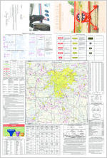
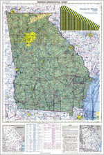
Relief shown by gradient tints, spot heights, and contours.
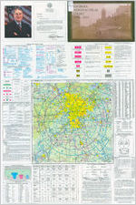
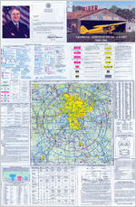
Text, color illustrations, and Atlanta terminal control area chart (Scale 1:500,000)--on verso.
Scale 1:1,000,000. Lambert conformal conic proj., Standard parellels 33° and 45°.
Covers the entire state of Georgia and separately the Atlanta region airspace.
Volumes for <1996-> issued by the Georgia Department of Transportation, Aviation Program.
Language
eng
External Identifiers
OCLC 13246595
NZ MMS ID 9910206260702931
Call Number T700.P8 S1 A35
Call Number T700.A9 S1 A35
Call Number G3921.P6 year