- Collection:
- Georgia Government Publications
- Serial:
- Georgia aeronautical chart / prepared by the Georgia Department of Transportation, Planning Data Services.
- Title:
- Georgia aeronautical chart / prepared by the Georgia Department of Transportation, Planning Data Services
- Creator:
- Georgia. Department of Transportation. Aviation Programs
- Contributor to Resource:
- Georgia. Bureau of Aeronautics, issuing body.
Georgia. Department of Transportation. Aviation Programs, issuing body. - Publisher:
- Atlanta : Georgia Dept. of Transportation, Bureau of Aeronautics, [19--]-
- Date of Original:
- 2000/2001
- Subject:
- Aeronautical charts--Georgia
- Location:
- United States, Georgia, 32.75042, -83.50018
- Medium:
- maps (documents)
state government records - Type:
- Still Image
- Format:
- application/pdf
- Description:
- Relief shown by gradient tints, spot heights, and contours
Text, col. illus., and Atlanta terminal control area chart (Scale 1:500,000) on verso
Scale 1:1,000,000. Lambert conformal conic proj., Standard parallels 33° and 45° - External Identifiers:
- Call Number GA T700.P8 S1 A35 2000-2001
- Metadata URL:
- https://dlg.galileo.usg.edu/id:dlg_ggpd_y-ga-bt700-pp8-bs1-ba35-b2000-h2001
- Digital Object URL:
- https://dlg.galileo.usg.edu/do:dlg_ggpd_y-ga-bt700-pp8-bs1-ba35-b2000-h2001
- Language:
- eng
- Extent:
- map : col. ; 60 x 51 cm., folded to 16 x 26 cm.
- Holding Institution:
- University of Georgia. Map and Government Information Library
- Rights:
-

~~,9.! ...9.
<I
)
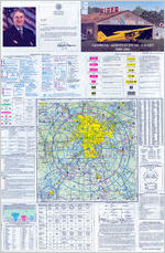
STATE OF GEORGIA
OFFICE OF THE GOVERNOR
ATLANTA 30334-0900
RoyE.Bames
GOVERNOR
GREETINGS: Welcome to Georgia! There is no better way to explore our beautiful
state than by air. travel. Whether it is for business or pleasure, our state has much to offer the air traveler.
This open edition of the Georgia Aeronautical Chart contains a complete update on the 109 open-to-the-public airports throughout the state. It is intended to insure the accuracy and safety of your air travel, and we are pleased to invite you to enjoy what Georgia has to offer.
Best wishes for a safe and pleasant flight.
Sincerely,
AIRCRAFT SERVICE INC
RoyE. Barnes
AERONAUTICAL CHART LEGEND
Ai'por1s having Conlrpj Towers we shown 11 ~ a1 others n M!!9!:!!, Consult Akport/ Facllty Directory (Alf()) for datalls lnvoMng
aiport llg:lli'lg. navigation aids, ard servloos. For aodl!lon8I symbol k1lormatlon reler to the Chart U$er"& Guioo.
AIRPORTS
)
0
J- Otherthll'l hBro-slrlwad n.nways
Seepa-,a Base
D O l-lam-fufaced nrr.vays 1500 fl. to 8069 ft. 11 lenglh.
II "1P ~ Hanku1ooed n.nways ~tlwl 8069 ft. or ll0ITl8 ~nrr,.,ay!! lesshn 8069ft.
D ~ Opendotwtthrl hlirtl-6lllaood n.riwayconl',glntlcn ~ ~oppronnat&VOR, VOR-OME,or\,Qf!TAC
AJI roccgw.able l-artklrlac8d ru,ways, hckx:lng tlul8 clos8d, tre shown for vlsua! ldmtltlcslioo. Aiports may be pi.tilic or prMd8.
ADDITIONAL AIRPORT INFORMATION
....,,,....,_ Private 'M" -~ use haWlQ emergency cw-
~ A , Milay - Other than hartl-9.ffaced. Al mlltilry arportS in
~ ~
iden1llled by ~ A F B , NAS, AM' etc.
For cunpl8te airport illormation OOl1IUt DOD FL.JP.
0
lJrMlr1fied
4>
Abandoned - peY9d haWlg ~ value,
3000 IL or greeter
Ulralglt Fll{tt Panr. Selecied
~-A,Jalavalableard fleld terded(t.mg ncnnalwormQhou's deplct9d by uoo ol llcl<s (VOllld basic aiport symbol ( Nonnal workng hou'santMal ttnJ Frl 1000A.M. Ill 4.J P.M. local~ Coosult
AA9) for 98Nice availabMy at arporla will hMl-tufaced nnNIIYS
*jJ'OOtertlwll!Oelllt. Rotatr,g ailport beacon i1 operation s.niet to So.nlse.
AIRPORT DATA
BaxlncicMaFAR. 93
FSS
F.A.R. 91
~~==---. ._I NO SVFR---- L.ocatloll
: ~ - - -@ NAM El(NAM) ----ldEtltlller
* Rada"
CT-118 .3 0 ATIS 123 .8
Fu'rNays wlth Rl,;tll
285 L 72 122.9 5 -
Trafflc~{pubicuoo)-.. RP 23,34
UNICOM
~ p.,. (SeeAi'port/
VFR Advs y125. 0
dllyOir&clory)
Airport of Entry
FSS - ""'1!SerkeStation NO S VFR - Fbrad-wlngspedalVFJllli{l?lisprohiblted.
CT -118. 3 C<lnb'tjTOW9'Pl pm-yhquency
* .NFCT Non-F!ldera!CmlrolTOWIII" Sta-lnclcatasop8'allonpartthle. 5eetow8'fl'eclndell
tablAatioo for hcus r:I operation.
C) Indicates Comnon Traffic AcMlo:y ~ (CTAF)
ATIS 123 .8 AubnaticTerrnnl Information SGr.ice
ASOS/ AWOS 135.42 AlltanlltedSurfilceW(iolllarObaervhg 5y..teng Some A!'X)SIAW-05 facllties may not be locDtoo at aportl.
UNI CO M - Aeronaullcala:Msoryst.dlor!
VFR Advsy-VFJlAIMsofy~,w'IOWl'lwhereATlSnotava&allle
.-.:1 ~ l l o l l w ' h v l pmliY CTfrlq,ellcy.
285 . BevatJon i1 feet L L.lg1mg i1 operation SulS8t to Suirille L Lig:llt',g lrritatlofB ex1:s1, re(uto Ai'portl1=acltty Dktlctoly.
72 La,gthr,llongeetnn.wylnh..ndrad5 ofl8at; usable length may be less.
Wien lidty Ol'Wormation la laclclng. the l'QIIP8cilY8 ctwactar ts repl:lced byad!ish. Al llg'ltilJ oodes.ara-to ru,way~
I.Jltrled nr,way may not be the longest Of l{tlted full l9nglh.
Al tine!<DRI local.
RADIO AIDS TO NAVIGATION AND COMMUNICATION BOXES
0 VHF OMNI RA NGE (VOA)
~ VORTAC
El VOR-DME
Non-Directional
RadlQt)eacon (NOB)
NOB - CME
Q Olherf8ciltloo, I . & . . ~
" ~ Stations, FSS Outlats-
RCO.
i::::-:...:.....- '---.. / f I .;;;;;.,=,:,,:::...I no YOioe on this frequency.
1 22 . 1R
Ht CAGO C HI
Heavy lkle box hdlc:atel Fll(t,t Service Station (FSS'). FrequICies 121.5. 122..2, 243.0. llrld 255.4 (Canade 121.~ 126.7Wld243.0)
* .Operates less lhan conttuous or Qn.fwqve&t.
0 TWEB
(3 HWAS
ASOS/AWOS
- normally avallable at all F$$4 llrld llnl not shown abOW l)oxeg_ Al o t h e r ~ are shown.
For Local Alfport AdYlsOry 1.1119FSS1requency123.6.
0 ~7
----
R """""""'
Fraqueoc::iea abovo thi1 llne box a-e rernoted
to NAVAJO <:e. O l h e r ~ a t FSS
Q providing YOioe corrmmical!on may be avaAable
FSS providing ;:;--
as d9termiled by altitude iYld terraln. Consult
YOice ~
M'porlt'Facllit)' Orectory !or complettl Information.
ATC LIGHT SIGNALS
AIRPORT TRAFFIC SERVICE AND AIRSPACE INFORMATION TOPOGRAPHIC INFORMATION
Only Iha conll'Oled and ~ lW$p3C8
- =~~J~C effaci/lle below 18,000ft. MSLa-e Bhowr'l
on this chart. Al trnea are lotai.
-
CluB B Anl)IIC&
- - - - =.fR.8121ll/AIMJ
-
-
~Seou,ity"'-
Terming\ Rodc;ir Servic
Arec;i (T~A)
~ RoadMantere
- - - - Clas50Ai'space
r40;'1
L.: ~
Ceiling of Class O Aln;pe,ce In
1'11.lX!mdsalleat.(AIOOIJS celling value Indicate& Sl.l'faoe up to but not lncu;lwlg lhat value.)
- - - - ClaMEldlll~
Clau E Alrlpace wlll1 floor 700 ft. lbove~
A A - OBSTRUCTIONS
,hollo;loenr'A.aGncI.1.
100011.AGL
A ~&=-.
C1aSa EA.spacewlthtloor 1200 fl. or greatet above si.i.ca lhBt abuts Class GAnpace.
2400 MSL Dltfenmiate,st\xlo'sa1
.a.al"'"-.&-"- ClessE~giwt
4500 MSL tharl700 n. above..tace
Class E Anpece axl$t:& at 1200' AGL oole8$ otherwise declgnated at shown above.
Cla$S E ~ low altltud8 Fodaral Ai-ways ill'9 Indicated by Ol!lllt8r lile.
Intersection Arrows - directed towards
Intersection. \ racltls whklll 86tabll8h
7 132_,,.. V 69
TQtal mileage
~
between NAVAIOs on direct AkWays.
~ ---- ~ ~~~
~ ~ Adviool'y 1111d
~ MOA - Mlllary
_,Spacial~ Traffic ...,_
(see FAR. PM 93 lor
~r :;:k ...J....
Obstruction wl1h
~~:S-trne
A, or ' '
2 049 --:,~:.~
(11 49) -
~above'100fld
UC -----:,_:..~,.......:. i
NOTICE: Guywn&may extend ootwatl from struc:llrl.
MISCELLANEOUS
- 10 E - leogorllc Lb (1 895 V,t,UJE}
.- _,, * U u~ F1
Aast-.,g
_-..-..,,,,..._-- .,,,
y (See Airport/ Fllellty Ohculty.)
I ..,... A HAMI: (Magw1ta, Blue, arBlackl Cheek Poot
- ! - - ! - Power TrBllSllllsslon LileB
-------- AertalCable
Ulf'ldmarlr. Feature i;tadlum. factory. school, ~coine, etc.
'@g
"""""'""""'
L.ookoo1TOW6r p.17 (SiteNlMTl~
818 (Elevation Basa of Tower)
CG Coast Guwd Station
c:::t ~Track
- - - Tank water. oil or gas
0 OI WeU
Watw WeM
~ Mines And Quarries
-
11823 (ElevatlonofPaes)
(Pan symbol does not lndicllle a recommended
route or direction of 111ght and P8S8 eklvatlon dON not Indicate a recommended clearal'ICe altltude. Ho.z.atdou$ flight conditions may exl$t within and
near mountain pasS&II.)
Example: 2,500 feet
THIS CHART CONTAI NS MAXIM UM ELEVATION FIGUR ES IMEF). The Maximum Elevati on Figu res s hown in quadrang les bo unded by ticked lines of la titude and longitude a re represen ted in THO US ANDS and HUNDRE DS o f feet abov e m e an sea level. The MEF is based o n information avail ab le conce rning the highes t kn o wn feature in each quadrang le, inc luding te rrain
and obstructio ns (trees, tow e rs . antenna s. etc. ).
COLOR AND
ON THE GROUND
IN FLIGHT
Statute Miles aut' I iles
0
2
TYPE OF SIGNAL
Steady Green
- - -Flashing Green Steady Red
- - -Flashing Red Fleshing White
- - - Cl D D Alternating Red and Green
Cleared for takeoff
Cleared to land
Cleared to taxi Stop
Return for landing (to be followed by steady
green at proper time)
Give way to other a ir craft end continue circling
Taxi clear of landing area (runway) in use
Return to starting point on airport
Airport unsafe do not lend
(No Assigned Meaning)
General warning signal Exercise extreme caution
ECOMMENDED COMMUNICATION PROCEDURES AT UNCONTROLLED AIRPORTS
=ACILITV AT AIRPORT
FREQUENCY USE
OUTBOUND
INBOUND
UNICOM (No Tower r FSS)
. No tower, FSS, or INICOM
Communicate with UNICO M station on publis hed CTAF frequency (122.7, 122.8, 122.725, 122.975,or123.0) If unable to contact UN ICOM station, self announce p~ocedures on CTAF.
Self.announce on MULTlCOM frequency 122.9.
Before taxiing a nd before taxiing on the runway for departure.
Before taxiing and before taxiing on the runway for departure.
. No tower in peration, FSS open
. FSS closed (No bwer)
Communicate with FSS on C1AF frequency.
Before taxiing and before taxiing on the runway for departure.
Selfannounce on CTAF frequency.
Before taxiing and before taxiing on the runway for departure.
10 Miles out. Enter ing downwind, base, and final. Leaving the runway.
10 Miles out. Entering downwind , base, and final. Leaving the runway. 10 Miles out. Entering downwind, base, and final. Leaving the runway. 10 Miles out. Entering downwind, base, and final. Leaving the runway.
. Tower or FSS not in ,peration
Self announce on CTAF frequency.
Before taxiing and before taxiing on the runway for departure.
10 M!les out. Entering downwind, base, and fine!. Leaving the runway.
ATLANTA CLASS B AIRSPACE
OPERATING RULES AND PlLQT/EQUIPMfNT REQU!RMENJS Regordlen of W$0ther conditions, on ATC authorization i$ required prior to operoting within the Clo$S 8 Airspace. Pilots fflld not request an authorizotioo ta operate within lhe Clan 8 Aitspoce unle$$ the requirements of FAR 91 .215 and FAR 91.131 ore me t. Included
among those requirements are:
\. Unlen othe rwise authorized by ATC, an operoble twowoy radio capable of communicating with ATC
on appropriate frequencie$ for thot Class 8 Airspoce. 2. No person may take off or lond o civil aircraft at the HortsfieldA~nnla International Airport un less the
pilot in command holds ot lea$! o private pilot cerlificote.
3. No persor, may take off or land o civil aircraft at an airport within the Clan 8 Airspaci, or operate a
civil aircraft withi.n the Class B Air$poce unlen:
0
ja) The pilot in command holds ot lea$t a private pilot certificate or:
\b) The aircroft is operated by o student pilot who hos met the requirements of FAR 61.95
4. Unless otherwise authorized by ATC, each penon operating a large tu,:bine enginepowered aircraft to
or from a primary airport shall operate at or above the designated Roors while within the lateral limits
of the Closs BAirspoce . 5. An operable VCR or TACAN receiver for IFR operations.
6. A transponder with automatic oltitvde reporting equipment.
Si
0
NOTE: ATC may, upon notilica~on, immediately outhorize o deviotioo from the alti~ reporting equipment
requirement or for O transponder failure; however, other raquests for deviations from the ll'onsponder
equipment requirement must be submitted to the controlling ATC facility at leosl one hour before the proposed
opero~on.
FLIGHT PROCEDURES
IFR FLIGHTS - Aircraft operotin9 within the A~anlo Class B Air,.pace must be operated in accordance wilh
ATC deoronces ond instructions.
VFRFLIGHJS
1. Arriving aircraft should contact the appropriate approach control an specified fraquencies ond in
0
relation to geographic fixe$ shown on the accompanying chort. Although arriving aircroft may
be Op$rating beneath the floor of the Clan B Airspace on initial contact, communications should
be established with approach control in relation to the paints indicated for sequencing and
spacing purposes. 2. Aircroft deporting the primary airports are reque$ted to advise clearance de livery prior to taxiing of
their intended altitude and direction of Right to depart the Closs B Airspace. Aircraft deporting from
other thon the primary airports whose route of Right would penetrate the Class B Air~e should give this information lo ATC on the appropriate frequencies.
3. Aircraft desiring to transit the Closs 8 Airspace must obtain an ATC deoronce to enter the Closs B
Airspace ond will be handled on an ATC workload permitting basis.
ATC PROCEDURES
All aircraft will be controlled and separated while operating within the Clan B Airspace, except
helicopters need not be separated from other helicopters. Although rodor separation will be the primary
standard used, approved visual and other nonrodor procedures will be applied os raquired or deemed
appropriate. Traffic information on observed but unidentified. radar targets will be provided on a
workload permitting basis to aircraft operating outside the Closs B Airspace.
NOTE: Anignment of radar heodJng$ and/or altitudes is bo$ed on the provision that a pilot operating in accordance with visual flight ru l,u is expected to advise ATC if complia nce with on anigned route, radar heading or altitude will cauff! the pilot to violate $uch rules.
AIRSPACE CLASSIFICATION
1
CLASS A
j
CL.ASS E
Unccntroll1~
Alrporl
*Operation at same Class B airports requires a prillate certWicate; See FAR i 91.131.
...Visibitity & cloud clearance requirements increase above 10,000' MSL -Visibility & cloud clearance requirements decrease below 1;J!Xf AGL; Increase above 10.000' MSL and at night
{Sae FARS 91.155 or AIM~ 314.)
PHONETIC ALPHABET AND RADIOTELEGRAPH CODE
A-ALFA
-
B-BRAVO C-CHARLIE D-DELTA E- ECHO F-FOXTROT G -GOLF H -HOTEL
....----
.-- -
I-INDIA J -JULIETT K-KILO L- LIMA M-MIKE
------
N-NOVEMBER -
0-0SCAR P-PAPA Q-QUEBEC R-ROMEO
------
S-SIERRA T-TANGO U - UNIFORM V-VICTOR W-WHISKEY X-XRAY Y-YANKEE Z-ZULU 0-ZE-RO 1 - WUN 2-TOO 3-TREE 4-FOW-er 5-FIFE 6-SIX 7-SEV-en 8-AIT 9- NIN-er
..-. -
..----.---------.-----.---------------
Airspace Fealures
Previous Airspace Equivalent
Class A
Positive Control Area IPCA)
Operations Permitted
IFR
Class B
Terminal Control Area ITCA)
Class C
Airport Radar Service Area
(ARSA)
Class D
Airport Traffic Areas combined
with Control Zones
IFR and VFR IFR and VFR
IFR and VFR
Entry Prerequisites
Minimum Pilot Qualifications
Two-way Radio Commmunications
ATC Clearance
Instrument Rating
Yes
ATC Clearance
Student Certificate/ *Endorsed
Student
Yes
IFR Clearance/ VFR Radio Contact
Student Certificate
Yes
VFRMinimum Visibility
N/A
3 Statute MIies
3 Statute MIies
IFR Clearance/ VFR Radio Contact
Student Certificate
Yes
3 Statute MIies
VFRMinimum Distance from Clouds
500' below,
500' below,
Clear of
1,000'above,
1,000' above,
N/A
Clouds
and 2,000'
and 2,000'
horizontal
horizontal
Class E
Control Zones/ General Controlled Airspace
IFR and VFR
Clearance & Radio Contact
for IFR
Student Certificate
IFR
** 3 Statute MIies
** 500' below, 1,000'above, and 2,000' horizontal
Aircraft Separation
All
Conflict Resolution
N/A
Traffic Advisories
N/A
Safety Advisories
Yes
All
IFR, SVFR,
IFR, SVFR,
and runway ops and runway ops
IFR and SVFR
N/A
BetweenlFR and VFR ops
No
N/A
Yes
Workload
permitting
Yes
Yes
Yes
No
Workload permitting
Yes
SIGN and LOCATION
4-22
On Taxiways at Intersection with a Runway and at a Runway/Runway
Intersection
GUIDE TO AIRFIELD SIGNS
PILOT ACTION or SIGN PURPOSE
Do not cross unless clearance has been received (towered airport) or until clear (non towered airport). At runway / runway intersections, hold short clearance has been accepted.
SIGN and LOCATION
J
Edge of Protected Area for Runway
HS-1
HS-1
Land and Hold Short Point for other than intersecting runways as instructed by ATC.
11 11 11
Edge of ILS Critical Area
4-APCH
Hold Position on Taxiway Located in Runway Approadi or Departure Area
Hold
Controlled Airport - Hold when instructed
by ATC.
Uncontrolled Airport ~ Proceed when no traffic conflict exists.
ILS Critical Area
Hold when instructed by ATC when approaches
are being made with visibility less than 2 miles or ceiling less than 800 feet.
IB+ l
Taxiways and Runways
[22 + 1
Taxiways
[OJ
Areas where Aircraft are Forbidden to Enter
Taxiway
Do not enter. Identifies paved areas where aircraft entry is prohibited.
Identifies taxiway on which aircraft is located.
[TERM + [
Taxiways and Runways
II
Runway
"SITTIN PRETTY" ORIGINAL ART BY GEORGIA ARTIST SAM LYONS
PILOT ACTION or SIGN PURPOSE
These sign s are used on controlled airports to identify the boundary of the runway protected area. It is intended that the pl lots. exiting this area would use th is sign as a gu ide to j udg e when the aircraft is clear of the protected area. These signs are used on controlled airports to id entify the boundary of the ILS crit ica l area. It is intended that pilots ex iting this area would use this sign as a guide to judge when the aircraft is clear of the ILS cri tical area. On Taxiways - Provides direction to turn at next intersection to maneuver aircraft onto named taxiway. On Runways - Provides direction to turn to exit runway onto named taxiway.
Provides general taxiing direction to named runway.
Provides general taxiing direction to identified destinations.
Provides remaining runway length in 1,000 feet increments.
Runway
30
Class G
Uncontrolled Airspace IFR and VFR None Student Certificate No
-* 1Statute Mlle
-* 500' below,
1,000'above, and 2,000' horizontal
None No Workload permitting Yes
Identifies runway on which aircraft is located.
tain
Taxiway Ending Marker Scale 1:500,000
farTar
Indicates taxiway does not continue.
GEORGIA COMMERCIAL BROADCAST STATIONS
CITY
CALI.
Adel
WBIT
Albany
WALG
Albany
WANL
Alma Alpharetta Americus
WAJQ WLTA WISK
Ashburn
WNNQ
Athens Athens
WBKZ WRFC
Athens
WXAG
Atlanta
WCNN
At lanta
WGST
Atlonto
WSB
Atlanta
WYZE
Augusta
WFAM
Augusta
WKIM
Austell
WAOS
Balnbrldye WMGR Bornesvl le WBAF
Boxley
WUFE
Blackshear WGIA
Blakely
WBBK
Bremen
WGMI
Brunswick WMOG
Brunswick WGIG
Cairo
WGRA
Ca lhoun
WJTH
Canton
WCHK
Carrollton WBTR
Cortersvltle WBHF
Cartersvl lle WXYC
Cedartown WGAA
Clarkesville WCHM
Claxton
WCLA
Clayton
WGHC
Cleve land
WRWH
Cochran
WVMG
Columbus WEAM
Columbus
WPNX
Columbus WRCG
Columbus WMLF
Commerce WJJC
Conyers
WPBS
Cornella
WCON
Covington WGFS
Cumming
WMLB
Cumming
WATS
Cuthbert
WCUG
Dohtonego WDGR
Dallas
WDPC
Dalton
WBLJ
Dolton
WTT1
Donalsonvllle WSEM
Douglas
WDMG
Douglas
WOKA
DouglosvlUe WDCY
Dublin
WMLT
Dublin
WXLI
East Point WTJH
Eostmon Eatonton
WUFF WKVQ
Elberton
WWRK
E llllov
WLJA
Fitzgerald WBHB
Fort Volley WXKO
Golnesvllle WDUN
Golnesvl lle WGGA
Glennville WKIG
Griffin
WKEU
FREQ
1470 1590 1250 1400 1400 13?0 1570 880
960 1470
680 640 750 1480 l050 1230 1600 930 1090 1260 1350 1260 1440 1490 1440 790 900 1290
1330 1'50 1270 1340 1490 1470
1370 1350 1440 1580 1460 1420 1270 1270 1050 1450 1430 1170 1420
850 1210 1500 1230 1530 1500 860 106.7 1520 1330 1230 1260
710 1520
1400 156<) 1240 1150
550 1240 1580 1450
CITY
CALL
Griffin
WHIE
Hartwell
WKLY
Hawkinsville WCEH Hazelhurst WVOH
Hlnesvltle Jasper
WGML WYYZ
Jesup
WLOP
LaFayette WQCH
U;1Gronge WLAG
LaGrange WTRP
Lowerencevllle WPLO
Loulsvllle
WPEH
Lyons
WBBT
Mocon
WBML
Macon
WDEN
Mocon
WMAC
Macon
WLCG
Madison
WYTH
Manchester WFDR
Morletto
WFTD
McRae
WYIS
Metter
WHCG
Mllledgevllle WMVG
Mllledgevllle WKGQ
Monroe
WKUN
Montezuma WMNZ
Moutrle
WMTM
Nashville
WNGA
Newnan
WCOH
Newnan
WNEA
Perry
WPGA
Quitman
WSFB
Reldsvllle WTNL
Rome
WLAQ
Rome
WRGA
Sandersville WSNT
Savannah
WCHY
Savannah
WBMQ
Savannah
WSGA
St.Marys
WECC
Statesboro WPTB
StotesbOro WWNS
Summervllle WGTA
Summerville WSAF
Swainsboro WXRS
Swainsboro WJAT
Sylvania
WSYL
Tallapoosa WKNG
Thomaston WTGA
Thomasville WPAX
Thomasville WHGH
Thomson
WTWA
Tifton
WTIF
Toccoa
WLET
Toccoa
WNEG
Trenton
WKWN
Tucker
WGUN
Va ldosta
WGOV
Valdosta
WJEM
Va ldosta
WVLD
Vidalio
WVOP
Vienna
WKTF
WornerRoblns WCOP
WarnerRoblns WRCN
WLOV
~~:rt~Y~~n WPLV
WestPoint WDWZ
Winder
WIMO
YoungHorris WZCM
FREQ
1320 980 610 920 990 1490 1370 1590 1240 620 610 1420 1340 900 1500 940 1280 1250 1370 1080 1410 1360 1450 1060 1580 1050 1300 1600
1<100 1300 980 1490 1390 1410 1470 1490 1290
630 1400 1190 850 1240
"'1180
1590 800 1490
1060 1590 1240 840 1240 1340 1420
630 1420 1010 950 1150 1450 970 1550 1350 1670 1370 1310 1490 1310
770
PILOT CONTROLLED LIGHTING (PCLI
Control System
Key Mike
3 step light system
7 times within 5 sec.
5 times within 5 sec. 3 times within 5 sec.
2 step light system
5 times within 5 sec. 3 times within 5 sec.
Intensity
High
Medium
Low
High
Medium
ACTIVATE
5 times within 5 sec.
(Rwy lights,
REIL, or VASQ
Lights on
Use UNICOM frequency unless otherwise indicated
VFR ALTITUDES/FLIGHT LEVELS
CONTROLLED/UNCONTROLLED AIRSPACE
UNDER VFR More than 3000" above the surface. Below 18.000" 0
,I. EVEN
,;; Thousands
u "
MSL
~~ plus 500 feet {4,500; 6,500;
0 8,500; etc.)
0
'o ~
ODD
o,
;
0
Thousands MSL
plus 500 feet
,
;
(3,500; 6.500;
0 C
7,500; etc.)
C
t
<
I '
40
VFR CHART VISIBILITY & CLOUD MINIMUMS
! 1,000'
I 1-MILE _ _ _ , / ~
,.ooo
5-MILE VISIBILITY
10,000' MSL 5- ILE YISlllllTY
f 1,000'
2,000-- - - ~
I ,oo
~ ~ ' > I ,.,.e .
3-MILE VISIBILITY
c,AH I A..1'.IICI
1- MILE VISIBILITY
(3 - MILE,NIOHT)
r-i,ooo CEILING..
I
ci.,u, o ...,u,ac1
ClAU (I UOVI 1100' AO!.
c,,.uo1now 1,00 u1
3-MILE VISIBILITY
Ill' m
t-Mli'E'Visii1L1TY'" C3 Mllf,NIOHT)
.:~~~,:~~~~:::;5;~--;;-~~~::.::.::_~__;
* Helicopters may operate with less than 1 mile v1s1b11ity, outside Class E airspace at 1200 feet or less above the surface, provided they are operated at a speed that allows the pilot adequate opportunity to see any air traffic or obstructions in time to avoid collisions.
** In addition, when operating within Class Dairspace beneath a ceiling, the ceiling must not be less than 1000 '. If the pilot intends to land or takeoff or enter a traffic pattern within Class D airspace, the ground visibility must be at least 3 miles at the airport. lf ground visibility is not reported at the airport, 3 miles flight visibility is required. (FAR 91.155)
REGULATIONS REGARDING FLIGHTS OVER CHARTED NATIONAL PARK SERVICE AREAS, U.S. FISH AND WILDLIFE SERVICE AREAS. ANO U.S. FOREST SERVICE AREAS
The lan ding of aircraft is prohibited on la nds or waters administered by th e Notional Park Service, U.S. Fish and
Wildlife Service or U.S. Forest Service without authorization from th e respective agency. Exceptions include,
1) when forced to land due to on eme rgency beyond the control of the operator, 2) at officially designated land in g
sites, or 3) on approved official busin11n of the Federal Government.
All a ircraft are requested to maintain o minimum altitude of 2,000 feel above the surface of the following,
Na1ional Parks, Monuments, Seashores, Lokeshores, Recreation Areas and Scenic Riverwa~ administered by the
Notional Park Service; National Wildlife Refuges, Big Game Refuges, Gome Ranges and Wildlife Ranges odmini
stared by the U.S. Fish and Wi ldlife Service; ond Wilderness and Primilive oreas administered by the U.S. Forest
Service. FAA Advisory Circular (AC) 9 136C, "Visual Flight Rules (V FR ) Flight Near NoiseSensitive Areas," defines
the surface as: th e highest terrain within 2,000 feet laterally of the route of fl ight, ,2!_the uppermost rim of a canyon
or valley.
Federal regulations also prohibit airdrops by parachute or other means of pe rsons, corgo, or obiects from oircrah
on lands administered by the three agenc ies without authorization from the respective agency. Exceptions incl ude:
1) eme rgencies involving the sa fety of human life, or 2) threat of serious property lass.
Boundary of National Park Service areas. U.S. Fish and Wildlife Service
areas and U.S. Forest Service Wilderness and Primitive areas.
VFR TRANSPONDER CODES MOOE A/ 3
Operation
Cod
I.VFR ........................... 1200
noo 2.RadioFaliur, ..... 1 min ,760015 min
Then rapett
noo 3.EMERGENCY
4.HIJACK............................ 7500
NOTE: Rafr1in from twitchingthrough
Code noo ,1600, 7500
STANDARD FREQUENCIES
EMERGENCV.......................................................... 121.500
Unicom
Airports without an operating control tower.... 122.700
Airports without an operat ing control tower.... 122.725
Airports without an operating control tower....122.800
Airports without an operating control tower.... 123.000
Airports without an operating control tower.... 122.975
Airports with a control tower............................. 122.950
Private airports (not open to the public)........... 122.725
High altitude.
........... ........................... 122.975
Heliports..
.................... 123.050
Heliports.........
... 123.075
Multicom
Airports with no tower,FSS, or Unicom..
122.900
Flight Service Stations
Transmit to VOR.
................................ 122.100
Flight Watch -Enroute Weather..............
122.000
All FSS (Non discrete frequency) ..................... 122.200
FSS- Non Tower Airports................................... 123.600
Anderson FSS............ ....................... .. ........ 123.600
Anniston FSS ...................................................... 122.300
Gainesville FSS....... .. ...... ................................... 122.500
Macon FSS.......................................................... 122.400
NOTICE TO USERS OF THIS CHART CHART IS NOT AUTHORIZED FOR FLIGHT USE
Aeronautical information on this chart is current as of August 1, 2000, and is obtained from the Federal Aviation Administration, the U.S. Department of Commerce, and the Georgia Department of Transportation.
This chart is to be used for informational purposes only. Pi lots shou ld use discretion in utilizing this chart.Printer and Publisher make no warranty, express or implied, as to the accuracy thereof. Consult appropriate NOAA aeronautical charts, NOTAMS,and Flight Information Publications for current information and supplemental data.
User comments are welcome. Please write to: Georgia Department of Transportation, Aviation Programs, 276 Memorial Drive SW, Atlanta, GA 30303.
COPYRIGHT 2000 STATE OF GEORGIA
Lambert Conformal Projection Standard Parallels 33 and 45
Nautical Miles 10
Statute Miles
10
0 0
o"'
"N '
0
0,
N
0
"N '
0
"N '
0
~
N 0
" N
0
"N '
0
"N '
0
gjo
"N '
0 OM
ON
N
0 N oN 0,
-0
N
-0
"
0 0 N 0
"
0
:';
0
"'
-0
"'
0
-"-'o" 33
--Oo
"'"'
0
"'
0
-0
N
-0
0
0 O;
0
"0 ' "
cl
0
"'
0
. "'
0
.0 ,
0
"'
0 N
0 N
oo
GEORGIA AERONAUTICAL CHART
Sca le 1:1,000,000
0
10
20
30
40
50
60
70
80
90
100
110
120
130
140
150
160
170
180
190
200
210
220 Nautical iles
0
10
20
30
40
50
60
70
80
90
100
110
120
130
140
150
160
170
180
190
200
210
220
230
240
250
tatute Mi es
85
84
.
83
HQWEE
., 500 i
Georgia Air Mileage Ch a rt
NUMBERS INDICATE NAUT ICAL MILES BETWEEN C ITIES AND ARE APPROXI M AT IONS AND SHOULD
ONLY BE USED FOR PLANNI NG PURPOSES
: : : : ::: ::: :~: : : ; : : ~: : : : n0
110 75 60 15 112 142 138 90 120 195 70 45 60 90 30 83 135 82 90 89 60 12
172 140 63 50 1 0 205 19-0 32 180 145 22 60 132 150
27 190 132 145 83 3 72 63
120 120 160 175 112 145 30 220 150 32 27 205 165 100 155 240 50 82 7 155 212 155 162 213
124 89 128 62 183 775 15 120 95 224 85 39 4 125 8 124 185 11 8 105 125 109 49 43 90 1
145 115 63 25 130 18
230 3 35 9 125 45 45 1 l 116 2 87 40 50 40 26 00 63 2
126 89 6 84 81 77
189 115 123 126 85 47 165 112 45 53 60 102 70
100 11 105 140
78 67 193 180 200 51
130 205 200 181 49 163 273 62 118 72 180 225 145 13 195 100 156 220
158 112 96 40 164 191
228 70 21 80 126 70 105 179 122 105 105 87 30 2 70 1 5 26 85 55 120 76 42
60 30 87 75 102 10
140 130 95 60 30 65 140 75 40 38 103 105 50 60 120 0 70 150 87 75 18 100
85 55 100 50 145 11
200 95 48 20 75 70 110 30 98 95 124 1 O 3if 42 110 170 13 110 BO 125 63 70
04 160 123 60 180 25
284 15 43 1 7 193 88 38 249 179 160 115 87 96 6 35 230 83 22 62 160 133 33
189 180 180 218 709 204
68 230 242 3 152 192 301 109 109 10 i:iij 221 192 175 210 50 229 250 175 0 146 02
172 147 148 179 71 203
97 200 207 185 123 145 263 97 58 72 107 192 151 140 180 55 178 220 140 3 105 165
110 95 90 12 55 150
70 165 150 130 80 95 175 70 30 3 90 120 103 10 750 67 135 190 11 2 3 62 140
85 55 75 40 713 120
lSO 95 60 4 63 45 110 112 70 72 98 80 17 25 90 145 40 112 62 93 35 5
60 84 217 215 221 34
143 215 213 127 84 1 6 297 87 143 90 220 9 769 12 210 110 176 232 182 150 151 188
33 64 190 168 173 74 57 203 70 116 1 2 194 1 2 37 150 249 39 108 0 160 204 132 122 185 80 162 210 152 110 95 162
70 105 231 217 194 68 70 240 90 105 230 194 151 77 191 282 52 114 85 195 24 773 160 222 85 194 250 190 735 135 20 129 104 1 170 87 168 27 175 135 94 185 197 160 77 128 236 55 37 3 115 183 143 12 170 5 169 205 130 50 96 155 50 120 28 80 43 190 122 85 175 170 112 175 130 115 50 115 135 72 93 17 60 80 80 90 140 120 130 57 2 72 90 03 120 256 209 155 117 27 225 30 52 '225 232 173 101 200 206 32 115 70 170 246 778 160 215 33 204 245 180 02 131 195 40 140 3 125 2 180 80 145 172 115 l 5 160 150 112 9 170 100 56 73 72 115 112 11 145 90 150 185 110 20 80 140
115 20 43 85 185 150 55 165 200 70 76 110 120 25 75 155 92 1 0 42 20 55 50 47 168 90 90 115 90 73 45
130 85 130 190 77 100 160 238 49 70 125 170 35 33 38 32 90 66 1 0 96 95 125 250 182 179 128 123 65 120 230 154 30 90 100 47
105 150 271 144 142 115 140 38 41 l 5 130 87 86 780 14 140 91 66 112 160 l
0
M 0 o
"N '
0a, N
0
"N '
0
"N '
.0
N 0
" N
0
"N '
0
"N '
0 N oN
"N '
-.0, 0
NN
0mo
~~
0 N
No
0,
8
N
-0
"
0 0
N
0
"
-0
a,
0
"'
0
:':
0
-o~"'
"
33
--."o' O
--0
"' "'0
0
:\
-0
N
0
:'.;
-0
-0
N
-0
0
8
0 O;
-0
0
32
0 0" 0,
oo
"' "
--2"" .,.
:..\ ''-461~-~
~?~ 15
,,OKEFENoK~ '~
"' ,, ~ ~>.ll!----G:U-,al
,S'l;\IAMP
68 t
~.::. -e-
0
"' 0 "'
0
."' 0
.0 ,
0
"'
0
"'
\
0
\
N
\
0 N
I
I
\
' \
s~0
\
\ 00
3000 2000
Statute Miles Nautical Miles
85
84
830
82
81
0
10
20
30
40
50
60
70
80
90
100
11 0
120
130
140
150
160
170
180
190
200
2 10
220
230
240
250
tatule Miles
0
10
20
30
40
50
60
70
90
100
110
120
130
140
150
160
170
180
190
200
210
220 Nautical ;/es
SoulherQ
0 Tolfair-
Wheeler Co
QUICK THRUST FT. STEWART 6c GATOR MOAS
0
Baxie -
O Bacon
0
co
Doll9IOS
Cai Grody
tur o 0
..1 ust Thom
~ .....
0 Tallohassee Reg
-: 'J""Int
' - . : NS
m
PREPARED BY AVIATION PROGRAMS, GEORGIA DEPARTMENT O F TRANSPORTATION
SPECIAL U SE AIRS PACE IN G EORG IA
NUMBER LOCATION R-3002 A FT. BENNING
R-3002 B Fl BENNING
R-3002C,E FT, BENNING
R-3002D FT. BENNING
R-3002F FT, BENNING
R-3004 FT GORDON
R-3005A, B,O,E R-3005C
FT STEWART FT STEWART
R-3007A TOWNSEND
R-3007B TOWNSEND
R-3007C TOWNSEND
R-3007D TOWNSEND
R-3007E TOWNSEND
R-3008A R-3008B R-3008C R-3008D
GRAND BAY WPNS RNG GRAND BAY WPNS ANG GRAND BAY WPNS RNG GRAND BAY WPNS RNG
RESTRICTED AREAS
ALTITUDE TIME OF USE
To 4000
INT. 0600-0200
6 HRS ADV
4000 -8000
INT 0600-0100
6 HRS ADV
8000-14000 JNT. By NOTAM
6 HRS AOV
To 8000
INT. 0600-0200
6 HRS ADV
14000To FL250 INT. By NOTAM
6 HRS ADV
To 16000
By NOTAM
24 HRS ADV
To 29000
0600-24000
24 HRS ADV
To 29000
0600-0300 24 HRS ADV
1500AGL To
5000 500AGLTo 5000 100 AGL To 13000 1200AGL To 13000 To 13000
0800-1700 Mo-Fr 24 HRS ADV 0800-1700 Mo-Fr 24 HRS ADV 0800-1700 Mo-Fr 24 HRS ADV 0800-1700 Mo-Fr 24 HRS ADV 0800-1700 Mo-Fr 24 HRS ADV
To 10000
lOOAG LTo 10000 500 AGL To 10000 10000 To but not incl FL230
0700-2200 Mo-Fr 6 HRS ADV 0700-2200 Mo-Fr 6 HRS ADV 0700-2200 Mo-Fr 6 HRS ADV 0700-2200 Mo-Fr
6 HRS ADV
CIA COLUMBUS TWA
COLUMBUS T.WR
COLUMBUS TWR
COLUMBUS TWA
ZTLCNTR
ZTl CNTR
ZJX CNTR
ZJX CNTR
ZJX CNTR
ZJX CNTR
ZJX CNTR
ZJX CNTR
ZJX CNTR
VALDOSTA APP CON VALDOSTA APP CON VALDOSTA APP CON VALDOSTA APP CON
NAME BENNING
BULLDOG A
BULLDOG B BULLDOG D
MILITARY OPERATING AREAS
ALTITUDE
TIME OF USE
CIA
500 AGL To 8000
0700-2000 Mo-Fr OCCAS Sa-Su By
CO LUMBUS TWA
NOTAM
500 AG LTo but
INT. 0700-2230
ZTL CNTR
not incl. 10000 10000 500 AG LTo 17000
INT. 0700-2230 INT.0800-1800 Mo-Fr w/R-30004
ZTL CNTR ZTL CNTR
FT. STEWART Bl 500 AGL To 4SS9
FT. STEWART B2 5000 To 10000 FT. STEWART Cl 500 AGL fo 2999
FT. STEWART CZ 3000 To 10000
GATOR 1
14000
GATOR 2 MOODY 1,3
13000To 14000 8000
MOODY Z NORTH 500 AGL To but not incl. 3000
MOODY 2 SOUTH 100 AGL To but
not incl. 8000
MOODY 3
8000
QUICK THRUST E lOOAG LTo but not incL 500AGL
QUICK THRUST F 100 AG LTo but not incl. 3000
QUICK THRUST G,H
1D000 To 14000
QUICK THRUST I 100 AGL To 14000
QUICK THRUST J 8000 To 14000
QU ICK THRUST L 12000 To 14000
QUICK THRUST M l lOOOTo 12000
QUICKTHRUSTN 500 AGL To 3000
INT. 0600-2200 Mo-Fr By NOT.AM INT. 0600-2200 Mo-Fr By NOTAM 0700-2200 Mo-Fr EXC HOL 0800-1700 Mo-Fr 07D0-2300 Mo-Fr OCCAS Sa-Su By NOT.AM INT. 0700-2300 Mo-Fr OCCAS Sa -Su By NOTAM INT 0700-2300 Mo-Fr OCCAS Sa -Su By NOTAM 0700-2300 Mo-Fr DCCAS Sa-Su By NOT.AM INT. SR-SS Up to 14 Days Twice a Yr By NOTAM INT. SR-SS Up to 14 Days Twice a Yr By NOTAM INT. SR-SS Up to 14 Days Twice a Yr By NOTAM INT. SR-SS Up to 14 Days Twice a Yr By NOTAM INT. SR-SS Up to 14 Days Twice a Yr By NOTAM INT. SR-SS Up to 14 Days Twice a Yr By NOTAM INT. SR-SS Up to 14 Days Twice a Yr By NOTAM INT. SR -SS Up to 14 Days Twice a Yr By NOTAM
ZJX CNTR ZJX CNTR ZJX CNTR ZJX CNTR ZJX CNTR ZJX CNTR ZJX CNTR
ZJX CNTR
ZJX CNTR
ZJX CNTR
ZJX CNTR
ZJX CNTR
ZJX CNTR
ZJX CNTR
ZJX CNTR
ZJX CNTR
ZJX CNTR
ZJX CNTR
COPYRI GHT 2000 STATE OF GEORGIA
WARNING
The adjacent chart is to alert you to the existence of Low Altitude Military Training Routes that traverse our State. These routes may change, be deleted, or new ones added. Check with the closest Flight Service Station for current information.
Three types of routes exist: 1)VFR Low Altitude Training Routes (SR) -250 KIAS or less 2)VFR Military Trai ni ng Ro utes (VR) - in excess of 250 KlAS 3) IFR Military Train ing Routes {IR) - in excess of 250 KIAS
Depending on the type of route, flights may be conducted at altitudes from 10,000' MSL down to the surface (IAW FAR 91.79), at any speed up to but not including supersonic, during the hours of daylight or dark, in instrument flight conditions or visual flight conditions or any com bination thereof.
NOTICE TO USERS OF THI S CHART
CHART IS NOT AUTHORIZED FOR FLIGHT USE
Aeronautical information on this chart is current
as of August 1, 2000, and is obtained from the
Federal Aviation Administration, the U. S. Depart-
ment of Commerce, and the Georgia Department
of Transportation.
This chart is to be used for info rmational pur-
poses only. Pilots shou ld use discretion in utiliz-
ing this chart. Printer and Publisher make no war-
ranty, express or implied, as to the accuracy
thereof. Consult appropriate NOAA aeronautical
charts, NOTAMS, and Flight Information Publica-
tions for current information and supplemental
data.
User comments are welcome. Please write to:
Georgia Department of Transportation, Aviation
Programs, 276 Memorial Drive SW, Atlanta, GA 30303.
g
M ILITARY
VR
"
TRAINING ROUTES
Roote Be91n ern,
...J.L* Type Point Point
*** -_.i1i.RL._**
QAfkens
nlel
, ust,:, AUGUSTA
0
Reg
~~..r~
IR 18
Nofe: Please notify the GEORGIA DEPARTMENT OF TRANSPORTATION, AVIATION PROGRAMS, ATLANTA, GEORGIA 30303 of add itions and corrections noted In us ing fhls chart .