- Collection:
- Georgia Government Publications
- Serial:
- Georgia aeronautical chart / prepared by the Georgia Department of Transportation, Planning Data Services.
- Title:
- Georgia aeronautical chart / prepared by the Georgia Department of Transportation, Planning Data Services
- Creator:
- Georgia. Department of Transportation. Aviation Programs
- Contributor to Resource:
- Georgia. Bureau of Aeronautics, issuing body.
Georgia. Department of Transportation. Aviation Programs, issuing body. - Publisher:
- Atlanta : Georgia Dept. of Transportation, Bureau of Aeronautics
- Date of Original:
- 2007/2008
- Subject:
- Aeronautical charts--Georgia
- Location:
- United States, Georgia, 32.75042, -83.50018
- Medium:
- maps (documents)
state government records - Type:
- Still Image
- Format:
- application/pdf
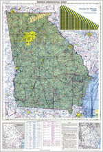
- Description:
- Relief shown by gradient tints, spot heights, and contours
Text, col. illus., and Atlanta terminal control area chart (Scale 1:500,000) on verso
Scale 1:1,000,000. Lambert conformal conic proj., Standard parallels 33° and 45° - External Identifiers:
- Call Number GA T700.A9 S1 A35 2007-2008
- Metadata URL:
- https://dlg.galileo.usg.edu/id:dlg_ggpd_y-ga-bt700-pa9-bs1-ba35-b2007-h2008
- Digital Object URL:
- https://dlg.galileo.usg.edu/do:dlg_ggpd_y-ga-bt700-pa9-bs1-ba35-b2007-h2008
- Language:
- eng
- Extent:
- map : col. ; 60 x 51 cm., folded to 16 x 26 cm.
- Holding Institution:
- University of Georgia. Map and Government Information Library
- Rights:
-
