- Collection:
- Georgia Government Publications
- Serial:
- Georgia aeronautical chart / prepared by the Georgia Department of Transportation, Planning Data Services.
- Title:
- Georgia aeronautical chart / prepared by the Georgia Department of Transportation, Planning Data Services
- Creator:
- Georgia. Department of Transportation. Aviation Programs
- Contributor to Resource:
- Georgia. Bureau of Aeronautics, issuing body.
Georgia. Department of Transportation. Aviation Programs, issuing body. - Publisher:
- Atlanta : Georgia Dept. of Transportation, Bureau of Aeronautics
- Date of Original:
- 2002/2003
- Subject:
- Aeronautical charts--Georgia
- Location:
- United States, Georgia, 32.75042, -83.50018
- Medium:
- maps (documents)
state government records - Type:
- Still Image
- Format:
- application/pdf
- Description:
- Relief shown by gradient tints, spot heights, and contours
Text, col. illus., and Atlanta terminal control area chart (Scale 1:500,000) on verso
Scale 1:1,000,000. Lambert conformal conic proj., Standard parallels 33° and 45° - External Identifiers:
- Call Number GA T700.P8 S1 A35 2002-2003
- Metadata URL:
- https://dlg.galileo.usg.edu/id:dlg_ggpd_y-ga-bt700-pp8-bs1-ba35-b2002-h2003
- Digital Object URL:
- https://dlg.galileo.usg.edu/do:dlg_ggpd_y-ga-bt700-pp8-bs1-ba35-b2002-h2003
- Language:
- eng
- Extent:
- map : col. ; 60 x 51 cm., folded to 16 x 26 cm.
- Holding Institution:
- University of Georgia. Map and Government Information Library
- Rights:
-

)?.f....9..(z1'
\C;;l
i'-;-r&
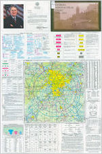
STATE OF GEORGIA
OFFICE OF THE GOVERNOR
ATLANTA 30334-0900
Roy E. Barnes GOVERNOR
GREETINGS:
Welcome to Georgia!
From our lofty mountains in North Georgia to our sandy beaches to the south, I invite you to visit the historic and scenic sites and various recreational facilities available to you throughout our beautiful state.
There is no better way to explore Georgia than by air. Whether for business or pleasure, you may enjoy the unique southern hospitality of our local airports. This complementary aeronautical chart is your guide to the 107 open-to-the-public airports found throughout the state.
Best wishes for a safe and pleasant flight.
Sincerely,
AERONAUTICAL CHART
2003
Roy E. Barnes
AERONAUTICAL CHART LEGEND
Akporls having Control Tpwoo; are shown rl ~ . al others iT ~ ConsultA>-port/ Facility Drectory (A.IFD) for details nllOMrlg
aipo,1: lighting. navigation akis, in:! services. For addil!ona! symbol lnlorma1ion refer to the Ctlirt User's Guide.
AIRPORTS
0 0 ()tle(tlM~nrrways J,.SaepianeBas,e
0
0
HMl-su1ao8d n..nways 1500 ft. tlJ 8089 ft. rl looglh.
~ ~ lll'"fW~lhln8089ft.OI"
aI.aI. ~"1P _.,. _ _ _ _ some multiple fUII~ leS!l ttwi e069 ft.
~~=~----. .AIRPORT DATA
Bo>cindlcataFA.R. 93
FSS
F.A.R. 91
:Su-velllw\oe I I NO SVFR--- Loaitioo ___.... @ NAME (NAM) - - kwitifier
Rl;la-
CT -118.3 * (t ATIS 123. 8
Fu-rNays v.1thRli;lt
285 L 72 12 2.95 .__
r ! i i ~ TratlicPatt8ms(publlcuse)- RP 2334 VFR Adv$y 125.0
UNICOM
V Y,iJ' ~approxinateVOR,\IOR-OME, orVOfITAC
Airport of Entry FSS - Fi!j,IServleeStation
NO SVFR - F"IXOdV>tlg spooia,I \/FR llflJt Is prohibited.
,,, racoglizablehwd~ nrM,:i:ys, ~thoslldosed,.-e
$hewn for visual identllcation. Ai-ports l1'llr)' be public OI" priyat&.
ADD1Tl0NAL AIRPORT INFORMATION Pr!vala " M' . flloni)Ublio ui.e haYing e,:oergoocy a
IRl'Q' --- Mililay Ottl8I" l1an ~ All miltwy alrport$ati
~ "={/
ldenti1lud byoobreviationsAFB, t-lAS, AAF, ate.
Forcomplet& airport im;Jrmrioo cor-.u1t DOO Fl.I'.
l.lnwrffled
Aban'.loned paved IJlb-ali!;t1t
GT -118.3 COntrolTower~ pn11illytequoocy
* .NFCT - Noo--Fedeml Conlrol Tower Star rdleatel operation part-tmo. Sae t o w Q r ~ tabulation fQr" hours ol operation. C) lndica(es CO<nmOl"I Tratlk: AtJ-;wy Fl'flqu9nr;:NB (CTN')
ATI S 123.8 Automallc Terminal lolormation S..W:. ASOS/ AWOS 135.42 .Al.nnated ~ Weathilr Obsaving Systems. Sonl& A!'.t:JS/AWOS rac11it1eis may oot be kx:at8d at awportS.
UN ICOM - Aeronwticm~statlon VFR Advsy - VFRM-mory5el"vlooltiowflwtw9A11Snotavda!:,ie
and fmcf.JancYlsolhel-hn 18J111YCT~.
haYlogllnlilak. ......, A{#lt Park 285 - Be>,ation ii loot
4>
3COO ft. or !JOOt1!f
Selected
$ervk:e$-fuel avallable ;n1 field unled dung normal working hcus
depicted by us. of tici<s aroi.rKl batlc M'pOl1 symbol (Normal WO!khg hours.-eMon lhnJ Fn 10:00A.M. k>4.-00 P.M. localtine.) eor...tt
MU for aarvio& avallebllily atai"porls with hel"d--...rfaoed ~
*{1"00.ter~8069ft. Rotatr,g ai"port beacon !n operation Sl.nset to &n!sa.
L L.1g1.-,g rlopEr.ltioo s..ns.t klStnisa ~L us,,tklgllmilatlonseitist,relw
to ~ d t y Di"ectooy. 72 l.a-iglhollorQeslruiwaylnhlsldrodsoffNI;
usabklkw"Qthmaybelim.
When foollty or !nfamatlon Is lilckTig, mo roopaclMI chWaclflr
replaced by a dash. M ~ oodM: ruler to nnMri ~ Ligited n.,iway may rd be ttw, longest lglted u leiogth.
Al1ir,esanilocal.
RADIO AIDS TO NAVIGATION AND COMMUNICATION BOXES
VHF OMNI RANGE (VOA) VORTAG VOR-D ME
Non-Dlrectional Radiobaacon (NDBJ
NOB- DME
0 Other foo.i:ies, I.e., Commercial
Broadcast Stations, FSS OudetsSCO, "'-
122. R 122.6 123.
u--OAKDALE
362*116.8 OAK ::"":'---
* .no voioo on this frequency. Operates less than oonlinuous or O n ~
0 -"TWEB
(t - ltWAS
e - ASOS/ AWOS 122 1R ~
............... /
I 122.1R
ICHICAGO CHI
Heavy llne box ndlcales Fli!.f1t 5etvlce S1atiorl (FSS). Frequencies 121.5, 122.2, 243.0, 811d 255.4 (Canada . 121.5, 126.7and 243.0) areoormalty available at all FSSs anoa-e
not flllc7n11 abov& l>Oxel;. Al at\urfraquarlcle8 ara shown.
For Local Aitport Ad'll$ory u,e FSS fT9qlieoCy 123.6.
R Rooelwooty
7 ------- Frequer,cl8s aOOY8th ii llneboxinrumoted toNAVAIDslte OlherlrequeociesalFSS
providing VOIOO comrnunlC811on may be avaflable
FSS providing -:;;-
as determined by altitud8 8'ld t&rrail1 Consult
voioe COOllTIU'licatl
Alrport/Fadllty Dnictory tor oomplele rllomla1!on.
ATC LIGHT SIGNALS
AIRPORT TRAFFIC SERVICE AND AIRSPACE INFORMATION TOPOGRAPHIC INFORMATION
Only ttw, controlled aod r..wd airspQoe effective below 18,000 It. MSl... a,, shown on this chart. All t1mee W11 loeal.
-
Clas$8Alrspaoe
-=I~J!:~c
- - - - ~~t~R.91.2Hl/AJM.J
-
-
National Security An)a,
Terminal Rodor Service
Areo {TRSA)
- - - - Class D Ah"spac,a
Lr.:4'0;:'.1,
Ceiling of ClaS& DAirsp&c,e lll
hu"ldNds offoot. (A ITW1U!I ceNk1ll valuo lndlcat8s &Urlaoo up to but not Including that \lalue.)
- - - - ClaalE(sfe)Alrapace
CIMa eAirspace with floor
700 ft. above surlaoo.
,>.l....
.M.
OBSTRUCTIONS
1oooft.lM"ld h111"AGL
Jr,. below / ,\ 1000tt.AGL
~&=-
Class e Alrspao8 witti floor 12001L or grnater a.b<we surface
that llbuts Class G Alrspa(:e.
,2_4.0.,0...M._,.S_.L Comlas-srtE1aAtJor$opln\Co$oQrrs11o8f1er
4500 MSL thwi700tt.abovesurfaoe
Class EAirspace a:dsts at 1200AGL un1"s OltMNWise ~ e d as shown above.
.....,,.....
l t ~~:tkoo or
--==i:.~ 2049
Obstruction with
(1149) -
H~abovegroond
UC ...____ Underoonstructionor
ci.ss EAirapacelow altitude FadaralAawaya
raportoo: position and
aro lncllcated by cen;..-i.-.e.
elevation l.l'Wllflf!Eld
lotersectlon NrOW& 111"9 dlracted toward$
NOTICE: Guy wk"ea may
facltlt!a which establ~ lnter=tk.ln.\
-r- 132 _.,.. V 89
Tota1m11eeg&
~
b,eotween NAVAID$ oo dlfflc1 Airways.
, ~ A * ~ Prohibited, Re$tr1Ch)d,
W&.mlng and Alert NOO$ Canadlan Advisory and
eldend outward from $1ruCtl.r8G.
MISCELLANEOUS
-10 E - tllDg()llk: lile {2000VALUE)
Cl -- ,~=.M_er_ -~ ~ MOA-MIiitary
~ Operations An)a,
N- Sp&clalAlrportTmflic Ar9as
_,(Sae FAR.Part 93 for
PartldluW Jumping Aroo.
(Soo
fo,'1y - I
A HAMI: (Magenta, Bluo, or BlaCk)
/ '
Visual Check Point
- ! - - ! - PoworTransmlssion Lines
- - - - - - - - Aerial Cable
l...alldmark Feature - stadium, lactory, school, golf courae, etc.
~ Outdoor Theatre
LookoutTower p.17 (Sile Number} 0 618 (Elavatlon Base of Tower)
+CG Coast Guard Station
i=l RaceTraCk
- - - Tank -water, oil orgas
0 O!Woll
e Wall"Well
~ MiWsAndOua.nies
-
11823 (EtevatlonofPass)
{Pass symbol does not Indicate a rar:ommended
rout11 or dirootion of flight and pass elevation doos not Indicate arecommooded cloarance altitude. Hazardous flight conditions may eKist wlthlll and near mountain passes.)
Example: 2,500 fee t
THIS CHART CONTAINS MAXIMUM ELEVATION FIGURES (MEF). The Maximum Elev<1tion Figures shown in quadrangles bounded by ticked lines of latitude and longitude are represented in THOUSANDS and HUNDREDS of feet above mean sea level. T~e ME~ is bas~d on information available concerning the highest known feature in each quadrangle, including terrain
and obstructions {lrees, towers, antennas, etc.).
SIGN and LOCATION
4-22
On Taxiways at Intersection with a Runway and at a Runway/Runway
Intersection
HS-1
HS-1
4-APCH
Hold Position on Taxiway Located in Runway Approach or Departure Area
Hold
ILS Critical Area
Areas where A ircraft are Forbidden to Enter
Taxiway
Runway
COLOR AND TYPE OF SIGNAL
ON THE GROUND
IN FLIGHT
Statute Miles
10
utical Miles 10
0
10
20
4
10
20
ATLANTA CLASS B AIRSPACE
Steady Green
- - -Flashing Green Steady Red
- - -Flashing Red Flt1shing White
- - - c::::J CJ CJ Alternt1ting Red t1nd Green
Cleared to land
Cleared to taxi Stop
Return for landing Ho be followed by steady
green at proper t ime)
Give way to other air craft and continue circling
Taxi clear of !anding area (runway) i~ use
Return to starting point on airport
Airport unsafe do not land
(No Assigned Meaning)
General warning signal Exercise extreme caution
RECOMMENDED COMMUNICATION PROCEDURES AT UNCONTROLLED AIRPORTS
FACILITY AT AIRPORT
FREQUENCY USE
OUTBOUND
INBOUND
1. UNICOM (No Tower or FSS)
2. No tower, FSS, or UNICOM
Communicate with UNICOM station on published CTAF frequency (122.7,122.8, 122. 725, 122.975,or123.0) !f unhble to contact UNICOM station, selfannounce procedures on CTAF.
Selfannounce on MULTICOM frequency 122.9.
Before taxiing and before taxling on the runway for departure.
Before taxiing and before taxiing on the runway for departure.
3. No tower in operation , FSS open
4. FSS closed (No Tower)
Communicate with FSS on CTAF frequency.
Selfannounce on CTAF frequency.
Before taxiing and before taxiing on the runway for departure.
Before taxiing and before taxiing on the runway for departure.
5., Tower or FSS not in operation
Self-announce on CTAF frequency.
Before taxiing and
before taxiing on the runway for departure.
10 Miles out. Entering downwind, base, and f inal. Leaving the runway.
10 Miles out. Entering downwind, base, t1nd final. Leaving the runway.
10 Miles out. Entering downwind, base, and final. Leaving the runway. 10 Miles out. Entering downwind, base, and final. Leaving the runway.
10 Miles out. Entering downwind, base, and final. Lea ving the runway.
GUIDE TO AIRFIELD SIGNS
PILOT ACTION or SIGN PURPOSE
Do not cross unless clearance has been received (towered airport) or until c lear (non towered airport). At ru nway / runway intersections, ho ld short clearance has been accepted.
SIGN and LOCATION
Edge of Protected Area for Runway
Land and Hold Short Point for other than intersecting runways as instructed by ATC.
Controlled Airport ~ Hold when instructed by ATC. Uncontrolled Airport - Proceed when no traffic conflict exists.
Edge of ILS Critical Area
1:s ~ 1
Taxiways and Runways
Hold when instructed by ATC when approaches
are being made with visibility less than 2 miles
or ceiling less than 800 feet.
Taxiways
Do not enter. Identifies paved areas where aircraft entry is prohibited.
Identifies taxiway on wh ich a ircraft is located.
Taxiways and Runways
El
Runway
Identifies runway on which aircraft is located.
Taxiway Ending Marker
Scale 1:500,000
ATLANTA CLASS B AIRSPACE
OPERATING RULES AND PILOT/EQUIPMENT REQUIREMENTS. Regardless of weather conditions, on ATC authorization is required prior lo operating wilhin the Closs B Airspace. Pilots should not request an outhorizotion to operate within the C!ass B Airspace unless the requirements of FAR 91.215 ond FAR 91.131 ore met. Included among !hose requirements ore:
1. Unless otherwise aulhorized by ATC, an operable lwowoy radio capable of communicating with ATC on appropriate frequencies for that Closs B AirspaCt'I.
2. No person may take off or land o civil aircraft at the Hartsfie!dAtlonta lnterhotionol Airport unless the pilot in command holds al le<:1sl o private pilot certificate.
3. No person may roke off or land o civil aircraft ot on airport wi thin the Closs B Airspace or operate a civil aircraft withi,n the Closs B Airspace unless: (o) The pilot in command holds at least o private pilot certificate or: (b) The aircraft is operated by a stvdent pilot who hos met the requirements al FAR 61.95
4. Unless otherwi$8 authorized by ATC, each pe~ operating o large tur.bine enginepowered aircraft to or from o primary airport shall operate at or above the designated Aoors while within lhe lateral limits of the Closs B Airspace .
5. An operable VOR or TACAN receiver for !FR operations. 6. A transponder with automatic altitude reporting equipment.
NOTE: ATC may, upon notification, immecliotely authorize o deviation from the altitude reporting equipment requirement or for a tronspooder failure; however, other requests for deviotions from the transponder
equi"pment requirement must be submitted lo the controlling ATC facility ot !e,;nt one hour before the proposed
operofon. FLIGHT PROCEDURES
IFR FLIGHTS - Aircraft operating within the Afonta Closs BAirspace must be operated in accordance wilh
ATC clooronces ond instructions. VFR FLIGHTS -
1. Arriving aircraft should con!Clcl the appropriate approach control on specified frequencies ond in relation lo geographic fixes shown on the accompanying chart. Although arriving aircraft may be operating beneath the floor of the Ch;1ss B Airspace on initial contact, communications should be established with approach control in relation lo the points indicated for sequencing and
spacing purposes. 2. Aircroft deporting the pri_mory airports are requested to advise clearance delivery prior lo taxiing of
their intended altitude and direction of Right lo deport the Closs B Airspace. Aircraft departing from olher lhan the primary airports whose route of Right would penetrate the Closs B Airspace shou!d give
this information to ATC on the appropriate frequencies. 3. Aircraft desiring lo transit the Class B Airspace must obtain on ATC clearance lo enter the Closs B
Airspace and will be handled on on ATC workload permitting bosis.
ATC PROCEDURES All aircraft will be controlled and separated while operating within the Closs B Airspace, except helicopters need not be separated from other helicopters. Although rodar separation will be the primary standard used, approved visual ond other nonrodor procedures will be oppl ied as required or deemed appropriate. Traffic information on observed but unidentified. rodor targets will be provided on o workload permitting bosis to aircraft operating outside the Closs B Airspace.
NOTE: Assignment of rodar headjngs and/or altitudes is based on the provision that a pilot operating in accordance with visual flight rules is expected to advise ATC if compliance with on assigned route, radar heading or altitude will cause the pilot to violate such rules.
FL 60,000 FL 18,000
AIRSPACE CLASSIFICATION
CLASS e
*Operation at same Class B airports requires a private cert~icate; See FAR 91.131.
-Visibility & cloud clearance requirements increase above 10,000' MSL """Visibility & cloud clearence requirements decrease below l;lJIJ AGL; Increaseabove 10,000' MSLand at night
(See FAR 91.155 or AIM~ 314.)
PHONETIC ALPHABET AND RADIOTELEGRAPH CODE
. - A-ALFA
B-BRAVO
--..- .. - C-CHARLIE
D - DELTA E- ECHO
---.-. - F-FOXTROT
G -GOLF
-- -----.-. H- HOTEL
I-INDIA
--- .---- J - JULIETT
K- KILO
-- ----- L- LIMA
S-SIERRA T-TANGO U-UNIFORM V-VICTOR W-WHISKEY X-XRAY Y-YANKEE Z-ZULU 0-ZE-RO 1-WUN 2-TOO 3-TREE
M-MIKE
4-FOW-er
N - NOVEMBER -
5 - FIFE
O-OSCAR P-PAPA Q-QUEBEC R-ROMEO
-----
6-S/X 7-SEV-en 8-AIT 9-N/N-er
---------
0
Sl
Crest 30
Airspace Features Class A
Previous Airspace
Equivalent
Positive
Control Area (PCA)
Operations Permitted
IFR
Class B
Terminal Co ntrol Area (TCA)
Class C
Airport Radar
Service Area
(ARSA)
Class D
Airport Traffic
Areas combined
with Control
Zones
IFR and VFR IFR and VFR
IFR and VFR
Entry
Prerequisites
Minimum
Pilot
Qualifications
Two-way Radio
Commmunications
ATC Clearance ATC Clearance
Instrument
Rating
Student
Certificate/ *Endorsed
Student
Yes
Yes
IFR Clearance/ VFR Radio Contact
Student
Certificate
Yes
VFR Minimum Visibility
N/A
3 Statute MIies
3 Statute MIies
IFR Clearance/ VFR Radio Contact
Student Certificate
Yes
3 Statute MIies
VFR Minimum Distance from Clouds
500' below,
500' below,
Clear of
1,000'above,
1,000'above,
N/A
Clouds
and 2,000'
and 2,000'
horizontal
horizontal
Class E
Control Zones/
General
Controlled
Airspace
IFR and VFR
Clearance & Radio Contact
for IFR
Student
Certificate
IFR
** 3 Statute MIies
** 500' below, 1,000'above, and 2,000' horizontal
Aircraft
Separation
All
All
IFR, SVFR,
IFR, SVFR,
and runway ops and runway ops
IFR and SVFR
Conflict Resolution
N/A
Traffic Advisories
N/A
Safety Advisories
Yes
N/A
Between IFR and VFR ops
No
N/A
Yes
Workload permitting
Yes
Yes
Yes
No
Workload permitting
Yes
Class G
Uncontrolled
Airspace
IFR and VFR
None
Student Certifica1e
No
*** 1 Statute Mlle
*** 500' below, 1,000'above, and 2,000' horizontal
None
No Workload permitting
Yes
50
VFR CHART VISIBILITY & CLOUD MINIMUMS
I,...,.
1-MILE _ _ ,..... , I / ~
5-MILE VISIBILITY
2 , 0 0 0 - --
tD,000' IIISL 5 IILE Y1SIBILITY
f 1,100'
,. ~,~ .
3-MILE VISIBILITY
CIA$! I AIISUCI
1- MILE VISIBILITY
(3 - MILE,N!GHT)
* Helicopters may operate with less than 1 mile v1s1bility, outside Class E airspace at
1200 feet or tess above the surface, provided they are operated at a speed that allows the
pilot adequate opportunity to see any air traffic or obstructions in time to avoid collisions.
"* ln addition, when operating within Class D airspace beneath a ceiling, the ceiling must
not be fess than 1000'. If the pilot intends to land or takeoff or enter a traffic pattern within
Class D airspace, the ground visibility must be at least 3 miles at the airport. If ground visi-
bility is not reported at the airport, 3 miles flight visibility is required. (FAR 91.155)
REGULATIONS REGARDING FLIGHTS OVER CHARTED NATIONAL PARK SERVICE AREAS, U.S. FISH ANO WILDLIFE SERVICE AREAS. ANO U.S. FOREST SERVICE AREAS
The landing of aircraft is prohibited on lands or waters administered by the Notional Pork Service, U.S. Fish ond Wildlife Servic e or U.S. Forest Service without authorization from the respective agency. Exceptions include 1) when forced to land due to on emergency beyond the control of the operator, 2) of officially designated landing sites, or 3) on approved official business of the Federal Government. All oircroft ore requested to maintain o minimum altitude of 2,000 feet above the surface of the following, National Porks, Monuments, Seoshores, Lokeshores, Recreation Areas and Scenic Riverwoys administered by the Notional Park Service; National Wildlife Refuges, Big Gome Refuges, Game Ranges ond Wildlife Ranges admini stared by the U.S. Fish and Wildlife Service; and Wilderness and Primitive areas administered by the U.S. forest Service. FAA Advisory Circular (AC) 91 36C, "Visual Flight Rules (VFR) Flight Near NoiseSensitive Areas," defines the surface os: the highest terrain within 2,000 feet laterally of the route of flight, ~the uppermost rim of o canyon or valley. Federal regulations also prohibit airdrops by parachute or other means of persons, cargo, or ob jects from aircraft on lands administered by the three agencies without authorization from the respective agency. Exceptions include, l) emergencies involving the safety of human life, or 2) threat of serious property loss.
Boundory of Notional Pork Service areas. U.S. Fish and Wildlife Service areas and U.S. forest Service Wilderness ond Primitive oreos.
CELEBRATING GEORGIAs AVIATION LEGACY The Ben Epps Flyer 1907 - The first airplane built in Georgia
PILOT ACTION or SIGN PURPOSE
These signs are used on controlled airports to identify the boundary of the runway
protected area . It is intended that the
pilots. exiting this a rea would use this sign as a guide to judge when the aircraft is clear of the protected area . These signs are used on controlled airports to identify the boundary of the ILS critical area. It is intended tha t pilots exiti ng t his area would use this sign as a guide to judge when the aircraft is clear of the ILS critical area. On Taxiways - Provides direction to turn at next intersect i on to maneuver a i rcraft onto named taxiway. On Runways - Provides direction to turn to exit runway onto named taxiway.
Provides general taxi ing direction to named runway.
Provides general taxiing direction to identified destinations.
Provides remaining runway length in 1,000 feet
increments .
Indicates tax iway does not continue.
GEORGIA COMMERCIAL BROADCAST STATIONS
CITY
CALI.
Adel
WBIT
Albany
WALG
Albany
WANL
Alma
WAJQ
Alpharetto WLTA
Americus WISK
Ashburn
WNNQ
Athens
WBKZ
Athens
WRFC
Athens
WXAG
Atlanta
WCNN
Atlanta
WGST
Atlanta
WSB
Atlanta
WYZE
Augusta
WFAM
Augusta
WK IM
Austell
WAOS
Bainbridge WMGR
Barnesville WBAF
Baxley
WUFE
Black.shear WGIA
Blok.ely
WBBK
Bremen
WGMI
Brunswick. WMOG
Brunswick. WGIG
Coiro
WGRA
Colhoun
WJTH
Canton
WCHK
Carrollton WBTR
Cortersvil le WBHF
Cartersville. WXYC
Cei:lartown WGAA
Clarkesville WCHM
Claxton
WCLA
Clayton
WGHC
Cleveland WRWH
Cochron
WVMG
Columbus WEAM
Columbus WPNX
Columbus WRCG
Columbus WMLF
Commerce WJJC
Conyers
WPBS
Cornelio
WCON
Covington WGFS
Cumming WMLB
Cumming WATB
Cuthbert
WCUG
Dahlonega WDGR
Da llas
WDPC
Dolton
WBLJ
Dolton
WTTl
Donalsonville WSEM
Douglas
WDMG
Douglos
WOKA
Douglasville WDCY
Dublin
WMLT
Dublin
WXLI
East Point WTJH
Eastman
WUFF
Eatonton
WKVQ
Elberton
WWRK
Elli jay
WLJA
Fitzgerald WBHB
Fort Volley WXKO
Goinesville WDUN
Gainesv ille WGGA
Glennville WKIG
Griffin
WKEU
FREQ
1470 1590 1250 1400 1400 1390 1570 880 960 1470 680 640
750 1480 1050 1230 1600
930 1090 1260 1350 1260 1440 1490 1440
790 900 1290 1330 1450 1270 1340 1490 1470 1370 1350 1440 1580 1460 1420 1270 1270 105-0 1450 1430 1170 1420 850 1210 1500 1230 153-0 1500 860 106.7 1520 1330 1230 1260 710 1520 1400 1560 1240 1150 S50 1240 1560 1450
CITY
CALI.
Griffin
WHIE
Hartwell
WKLY
Hawkinsville WCEH
Hazelhurst WVOH
Hinesville WGML
Jasper
WYYZ
Jesup
WLOP
LaFayette WQCH
U;1Gronge WLAG
LaGrange WTRP
Lowerencevllle WPLO
Louisville WPEH
Lyons
WBBT
Macon
WBML
Macon
WDEN
Macon
WMAC
Macon
WLCG
Modison
WYTH
Manchester WFDR
Marietta
WFTD
McRae
WYIS
Metter
WHCG
MIiiedgeviiie WMVG
MIiledgeviiie WKGQ
Monroe
WKUN
Montezuma WMNZ
Moutrie
WMTM
Nashville
WNGA
Newnan
WCOH
Newnan
WNEA
Perry
WPGA
Quitman
WSFB
Reidsvllle WTNL
Rome
WLAQ
Rome
WRGA
Sandersville WSNT
Savannah WCHY
Sovannah WBMQ
Savannah WSGA
St.Marys
WECC
Statesboro WPTB
Statesboro WWNS
Summerville WGTA
Summerville WSAF
Swainsboro WXRS
Swainsboro WJAT
Sylvania
WSYL
Tallapoosa WKNG
Thomaston WTGA
Thomasville WPAX
Thomasville WHGH
Thomson
WTWA
Tifton
WTIF
Toccoa
WLET
Toccoa
WNEG
Trenton
WKWN
Tuck.er
WGUN
Voldosta
WGOV
Voldosto
WJEM
Voldosto
WVLD
Vidalia
WVOP
Vienna
WKTF
WarnerRobins WCOP
WarnerRobins WRCN
Washington WLOV
WestPoint WPLV
WestPoint WDWZ
Winder
WIMO
YoungHarris WZCM
FREQ
1320 980 610 920 990 1490 1370 1590 1240 620 610 1420 1340 900 1500 940 1280 1250 1370 1080 1410 1360 1450 1060 1580 1050 1300 1600 1400 1300 980 1490 1390 1410 1470 1490 1290 630 1400 1190
850 1240
950 1180 1590 800 1490 1060 1590 1240
840 1240 1340 1420
630 1420 1010 950 1150 1450
970 1550 1350 1670 1370 1310 1490 1310
770
PILOT CONTROLLED LIGHTING {PCL)
Control System
Key Mike
3 step light system
7 times within 5 sec.
5 times within 5 sec. 3 times within 5 sec.
2 step light
system
5 times within 5 sec.
3 times within 5 sec.
ACTIVATE
5 times within 5 sec.
(Rwy lighls,
REIL, or VASll
Intensity
High Medium Low
High
Medium
Lights on
Use UNICOM frequency unless otherwise indicated
VFR ALTITUDES/FLIGHT LEVELS CONTROLLED/UNCONTROLLED AIRSPACE
UNDER VFR . More than 3000" above the surface. Below 18,000' 0
I !:
EVEN
0
Thousands
J
u
MSL
, plus 500 feet
. (4,500; 6,500;
8,500; etc.) " ~
0 0d;,
ODD
o.
A
0
Thousands MSL
plus 500 feet
,
z
(3,500; 5,500; ~
7,500; etc.) C
;,
I
VFR TRANSPONDER CODES MODE A/ 3
Operation
Code
1.VFR ...... - - : = - : - 1200 2.Radiofeliure .... 7700 1 min ,760015 min
Then repeat
3.EMERGENCY.. 7700
4.HIJACK.......
......... 7500
NOTE: Refrain from switchingthrough
Code 7700 ,7600, 7500
STANDARD FREQUENCIES
EMERGENCY. ........................................................ 121.500
Unicom
Airports without an operating control tower.... 122 .700
Airports without an operating control tower.... 122.725
Airports without an operating control tower.... 122.800
Airports without an operating control tower.... 123.000
Airports without an operating control tower. ... 122.975
Airports with a contro l tower. .. ..... .
.... 122.950
Private airports (not open to the public) ........... 122.725
High altitude.......................
............. 122.975
Heliports.... Heliports.......
..... 123.050 ..... 123.075
Multicom Airports with no tower,FSS, or Unicom.
... 122.900
Flight Service Stations Transmit to VOR .
.... 122.100
Flight Watch-Enroute Weather.
...... 122.000
All FSS (Non discrete frequency)
.. 122.200
FSS~ Non Tower Airports.... Anderson FSS........... Anniston FSS .............. .
123.600 .. 123.600 ............... 122.300
Ga inesville FSS
.122.500
Macon FSS.............
122.400
NOTICE TO USERS OF THIS CHART CHART IS NOT AUTHORIZED FOR FLIGHT USE
Aeronautical information on this chart is current
as of April 1, 2002, and is obtained from the Federa l Aviation Administration, the U.S. Depart-
ment of Commerce, and the Georgia Department
of Transportation.
This chart is to be used for informational purposes only. Pilots should use discretion in utilizing this chart.Printer and Publisher make no warranty, express or implied, as to the accuracy thereof. Consult appropriate NOAA aeronautical charts,
NOTAMS,and Flight Information Publications for
current information and supplemental data.
User comments are welcome. Please write to: Georgia Department of Transportation, Aviation
Programs, 276 Memorial Drive SW, At lanta, GA 30303.
COPYRIGHT 2002 STATE OF GEORGIA
Lambert Conformal Projection Standard Parallels 33 ond 45
Nautical Miles l 0
tatute Miles
0
0
"N '
0
"N '
0
" N
0
" N
0
"N '
0
"N '
0
gjo
"N '
GEORGIA AERONAUTICAL CHART
Sca le l :l,000,000
0
10
20
30
40
50
60
70
80
90
0
10
20
30
40
50
60
70
80
90
100
85
4w
84
100
110
120
130
120
130
140
15
83
140 160
150 17
160 180
170
190
200
180 210
190 220
200 230
210 240
220 Noufico/ il&J
250
talute Miles
Georgia Air Mileag~ Chart
NUMBERS INDI CATE NAUTICAL MILES BETWEEN
C IT IES AND ARE APPROXIMATIONS AND SHOULD
ONLY BE USED FOR PLANN ING PURPOSES
0
<'lQ
"N '
0
"N '
0
"N '
0
~
0
" N
0
" N
"N '
0 N
oN
"N '
0
0
gN0<')
Ng<')0
'
0 N QN
0,
1.: ...I1 2.3 123. ..;
' . - ANN ISTON
0
0
~
:;;
N
0
"~ '
0
0
0
N
N
0
0,
~
0
0
"'
"~ '
0
~ "'
0
"'
0
'.:l
0 N
~
0 0
~
0
~
0
0,
0 0
.... 32
0
"'0
"'
0
"0 ' "
0
"'
0
"'
0
""
0 N
oo
0
"'
AA
133 .~ *
., IS'!215,:,f.85
2L 1A
A
l.o,
A
0 0
~
0 0
~
32'
0"0 '
"'
oo
"' "
18
(55J) ANDINA BEAC LS:3122.7
BEACH
0
"'
0
"
.0
0
"' "'
0 N 0 N
00
"""
W -15 9 A
"""
tatute Mil es
10
Noulico/ Miles 1
85
3w
84
' ' '
83
0
10
20
30
0
5
60
70
80
90
100
110
120
0
JO
20
30
40
50
60
70
80
90
JOO
110
82
81
140 120
150 130
160 140
170 150
180 160
190
20
170
210 180
20 190
230 200
24 210
250
tatute Miles
220 Nautical iles
..!:!E ~,,....,.,._
DaltonO
Blairsvtlle O
<} /
.,;
RESTRICTED & MILITARY
o0g:;"'
Toc=b ~ OPERATING AREAS
Habersham O
~
ODovid 0
Russell
O PicCkOens~
Fronklln Co O
Gilmer
Al'ltle!,onCo
\ 0
,_, Co.-nelillS
Mem Cobb CO- Gwinnett Co. Mc. COiium 0B rLs>e0
O~ree Winder
Elbert Co.Paiz
0 ~
O
Athens wi"r:co
Fulton COO ATLANTA
Modison
0
Wer,t~ Reg Harts~>eld- covr;, ton O l oGreenCo
~-"N~rn~r
Atlanta Intl
't,Jng
\
, co O
~
Thormon- 0 McDuffleCO
R-3004
0 Grlffin-
5poldlng Co
~'='- J>~.
o c a 11awov O
QGrantMem
Ba~ln
8 ~h!&~
Kaolin OLoolWill&
~-
Horris Ca
MACON
,._ II< ~
o
A"'"~ OPellka
Lewi~ B O
~COlumtM.15 Nw:tro COLUMBUS
Wilson Robins Q AFS
~ BENNING
0
Perry-
~
MCA
Houstoo
B E ue1 Co
o...,,,
AAF R-3002 SOUtherO
0 TelfalrWheelerCO
QUICK TH FT. STEWA GATOR M
o Plantation
Calr
--Grody
"~, T 0
-
0
~
0 Wr;rycross-
WoreCa
0( -1,=s;,r ' "iervllle
0
Tallahassee R~
PREPARED BY AVIATION PROGRAMS, GEORGIA DEPARTMENT OF TRANSPORTATION
SPECIAL USE AIRSPACE IN GEORGIA
- - - - - - ALERT & RESTRICTED AREAS - - - - - ~
NUMBER LOCATION
ALTITUDE
TIME OF USE
CIA
NAME
MILITARY OPERATING AREAS
ALTITUDE
TIME OF USE
A6ll4
MOODY AFB
R-3002 B FT. BENNING
R-3002C,E FT. BENN ING
R-30020 FT. BENNING
R-3002F FT. BENNING
R-3004 FT. GORDON
R-3005A, B,D,E R-3005C
FT. STEWART FT. STEWART
R-3007A TOWNSEND
R-3007B TOWNSENO
R-3007C TOWNSEND
R-30070 TOWNSEND
R-3007E TOWNSEND
R-3008A R-30088 R-3008C R-30080
GRAND BAY WPNS RNG GRAND BAY WPNS RNG GRAND BAY WPNS ANG GRAND BAY WPNS RNG
To 4000
4000-8000
8000- 14000
To 8000
14000ToFL250
To 16000
To 29000
To 29000
1500AGL To 5000 500 AG LTo 5000 100AG LTo 13000 1200 AG L To 13000 To 13000
To 10000
lOOAGL To 10000 SOOAGL To 10000 10000To but not incl FL230
0500-0200 Mo-Fr 24 HRS ADV INT. 0600-0200 6 HRS ADV INT. ByNOTAM 6 HRS ADV INT. 0600-0200 6 HRS ADV INT. By NOTAM 6 HRS ADV By NOTAM 24 HRS AOV 0600 -24000 24 HRS ADV 0600-0300 24 HRS ADV 0800-1700 Mo-Fr 24 HRS ADV 0800-1700 Mo-Fr 24 HRS ADV 0800-1700 Mo-Fr 24 HRS ADV 0800-1700 Mo-Fr 24 HRS AOV 0800-1700 Mo-Fr 24 HRS AOV 0700-2200 Mo-Fr 6 HRS AOV 0700-2200 Mo-Fr 6 HRS ADV 0700-2200 Mo-Fr 6 HRS AOV 0700-2200 Mo-Fr 6 HRS ADV
NDA/G
CO LUMBUS TWR
COLUMB USTWR
COLUMBUS TWA
ZTLCNTR
ZTLCNTR
ZJX CNTR
ZJX CNTR
ZJX CNTR
ZJX CNTR
ZJX CNTR
ZJX CNTR
ZJX CNTR
VALDOSTA APP CON VALDOSTA APP CON VALDOSTA APP CON VALDOSTA APP CON
COPYRIGHT 2002 STATE OF GEORGIA
BENNING
500 AGLTo 8000
BULLDOG A
BULLDOG 8 BULLDOG 0
500 AGLTo but not incl. 10000
10000 500 AGL To 11000
FT. STEWART Bl 500 AGL To 4999
FT STEWART B2 5000 To 10000 FT STEWART Cl 500 AGL To 2999
FT. STEWART C2 3000 To t0000
GATOR 1
14000
GATOR 2 MOODY 1,3 MOODY 2 NORTH
MOOOY 2 SOUTH
MOODY 3 UUICK THRUSH
13000To 14000 8000
500 AGL To but not incl. 8000 100 AGL To bLt not incl. 8000
8000 100 AGL To but not inct 500 AGL
UUICK THRUST F 100 AGL To but not incl. J(X)(l
UUICK THRUST G,H
10000 To 14000
UUICK THRUST I lOOAGL To 14000
QUICK THRUST J 8000 To 14000
QUICK THRUST L 12000 To 14000
UUICK THRUST M 1\000To 12000
QUICK THRUST N 500 AGL To 3000
0700-2000 Mo-Fr OCCAS Sa-Su By NOTAM INT. 0700-2230
INT. 0700-2230 INT.0800-1800 Mo-Fr w/R-30004 INT. 0600-2200 Mo -Fr By N0TAM INT. 0600-2200 Mo-Fr By NOTAM 0700-2200 Mo-Fr EXC HOL 0800-1700 Mo-Fr 0600-0200 Mo-Fr 0600-0200 Mo-Fr
0600-0200 Mo-Fr
0600-0200 Mo-Fr INT. SR-SS Up to 14 Days Twice a Yr By NOTAM INT. SR-SS Up to 14 Days Twice a Yr 13y NOTAM INT. SR-SS Up to 14 Days Twice e Yr By NOTAM INT. SR-SS Up to 140aysTwicea Yr By NOTAM INT. SR-SS Up to
14 Days Twice a
Yr By NOTAM INT SR-SS Up to
14 Days Twice a
Yr By NOTAM INT. SR-SS Up to
14 Days Twice a
Yr By NOTAM INT. SR-SS Up to 14 Days Twice a Yr By NOTAM
CIA COLUMBUS
ZTL CNTR ZTL CNTR ZTL CNTR ZJX CNTR ZJXCNTR ZJX CNTR ZJX CNTR ZJX CNTR ZJX CNTR ZJX CNTR ZJX CNTR ZJX CNTR ZJX CNTR ZJX CNTR
ZJXCNTR
ZJX CNTR
ZJX CNTR
ZJX CNTR
ZJX CNTR
ZJX CNTR
ZJX CNTR
WARNING The adjacent chart is to alert you to the existence of Low Altitude Military Training Routes that traverse our State. These routes may change, be deleted, or new ones added. Check with the closest Flight Service Station for current information.
Three types of routes exist: 1)VFR Low Altitude Training Routes (SR) -250 KIAS or less 2)VFR Military Training Routes (VR) - in excess of 250 KIAS 3) IFR Military Training Routes (IR) in excess of 250 KIAS
Depending on the type of route, flights may be conducted at altitudes from 10,000' MSL down to the surface (IAW FAR 91.79), at any speed up to but not including supersonic, during the hours of daylight or dark, in instrument flight conditions or visual flight conditions or any combination thereof.
NOTICE TO USERS OF THIS CHART
CHART IS NOT AUTHORIZED FOR FLIGHT USE
Aeronautical information on this chart is current
as of April 1, 2002, and is obtained from the
Federal Aviation Administration, the U.S. Depart-
ment of Commerce, and the Georgia Department
of Transportation.
This chart is to be used for informational pur-
poses only. Pilots should use discretion in utiliz-
ing this chart. Printer and Publisher make no war-
ranty, express or implied, as to the accuracy
thereof. Consult appropriate NOAA aeronautical
charts, NOTAMS, and Flight Information Publica-
tions for current information and supplemental
data.
User comments are welcome. Please write to:
Georgia Department of Transportation, Aviation
Programs, 276 Memorial Drive SW, Atlanta, GA 30303.
g
MILITARY
~,, TRAINING ROUTES
Room
eoo
"' Paint
- * *** ..-....:.'.!I!"il.....-.. **
,.
1B
Note : Please notify the GEORG IA DEPARTMENT OF TRANSPORTATION, AVIAT ION PROGRAMS, ATLANTA, GEORG IA 30303 of additions and corrections noted In using this chart.