- Collection:
- Historic Maps (Georgia Archives)
- Title:
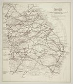
- "Georgia: Early Roads and Trails, circa 1730-1850"
- Date of Original:
- 1977
- Subject:
- Georgia--Maps
- Location:
- United States, Georgia, 32.75042, -83.50018
- Medium:
- maps (documents)
- Type:
- Still Image
- Format:
- image/jpeg
- Description:
- "The Early Road Network has been imposed on a 1932 base map from the United States Department of the Interior Geological Survey. Research of roads was done by John H. Goff. Printed by Georgia Department of Transportation, in cooperation with Surveyor General Department, Secretary of State."
Scale [ca. 1:1,000,000]. - External Identifiers:
- Metadata URL:
- https://vault.georgiaarchives.org/digital/collection/hmf/id/54
- Language:
- eng
- Extent:
- 15.5 x 17.75
- Original Collection:
- omf011, Historic Maps, Surveyor General, RG 3-8-65, Georgia Archives
- Holding Institution:
- Georgia Archives
- Rights:
-
