- Collection:
- Historic Maps (Georgia Archives)
- Title:
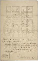
- Plan of Statesboro.
- Date of Original:
- 1803
- Subject:
- Statesboro (Ga.)--Maps
- Location:
- United States, Georgia, Bulloch County, Statesboro, 32.44879, -81.78317
- Medium:
- maps (documents)
- Type:
- Still Image
- Format:
- image/jpeg
- Description:
- Town lots. Josiah Everitt, C. S.
- External Identifiers:
- Metadata URL:
- https://vault.georgiaarchives.org/digital/collection/hmf/id/39
- Language:
- eng
- Extent:
- 7.75 x 12
- Original Collection:
- hmf0042, Historic Maps, Surveyor General, RG 3-8-65, Georgia Archives
Historic Maps, Surveyor General, RG 3-8-65, Georgia Archives - Holding Institution:
- Georgia Archives
- Rights:
-
