- Collection:
- Historic Maps (Georgia Archives)
- Title:
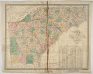
- "Map of North and South Carolina and Georgia, constructed from the latest authorities."
- Creator:
- Young, J. H. (James Hamilton)
- Contributor to Resource:
- Finley, A. (Anthony)
- Publisher:
- Philadelphia: A. Finley, 1827.
- Date of Original:
- 1827
- Subject:
- North Carolina--Maps
South Carolina--Maps
Georgia--Maps
Freedmen--North Carolina
Freedmen--South Carolina
Freedmen--Georgia
Slaves--North Carolina
Slaves--South Carolina
Slaves--Georgia - Location:
- United States, Georgia, 32.75042, -83.50018
United States, North Carolina, 35.50069, -80.00032
United States, South Carolina, 34.00043, -81.00009 - Medium:
- maps (documents)
- Type:
- Still Image
- Format:
- image/jpeg
- Description:
- Scale [ca. 1:1,774,000] (W 85°20'--W 75°20'/N 36°40'--N 30°10').
Relief shown pictorially
Prime meridians: Washington and Greenwich
Includes inset of table listing white, free black & slave population of each county based on Census of 1820
J. H. Young, sculp. - External Identifiers:
- Metadata URL:
- https://vault.georgiaarchives.org/digital/collection/hmf/id/38
- Language:
- eng
- Extent:
- 23.5 x 18.75
- Original Collection:
- hmf0141, Historic Maps, Surveyor General, RG 3-8-65, Georgia Archives
Historic Maps, Surveyor General, RG 3-8-65, Georgia Archives - Holding Institution:
- Georgia Archives
- Rights:
-
