- Collection:
- Historic Maps (Georgia Archives)
- Title:
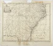
- Map of North and South Carolina and Georgia.
- Creator:
- Bowen, Emanuel, -1767
- Date of Original:
- 1747
- Subject:
- Southern States--Maps--Early works to 1800
- Location:
- Southeastern United States, 34.658488, -84.73441
- Medium:
- maps (documents)
- Type:
- Still Image
- Format:
- image/jpeg
- Description:
- "A New & Accourate Map of the Provinces of North & South Carolina Georgia &c. Drawn from late Surveys and regulated by Astronl. Observatns." By Emanuel Bowen, ca. 1747. In: Unidentified atlas, no. 76.
Scale [ca. 1:2,900,000] (W 88°--W 74°/N 38°--N 29°).
Relief shown pictorially
Includes note on the Cherokees and ornamental cartouche - External Identifiers:
- Metadata URL:
- https://vault.georgiaarchives.org/digital/collection/hmf/id/33
- Language:
- eng
- Extent:
- 18.5 x 16
- Original Collection:
- hmf0028, Historic Maps, Surveyor General, RG 3-8-65, Georgia Archives
Historic Maps, Surveyor General, RG 3-8-65, Georgia Archives - Holding Institution:
- Georgia Archives
- Rights:
-
