- Collection:
- Historic Maps (Georgia Archives)
- Title:
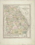
- "A New Map of Georgia with its Roads & Distances."
- Creator:
- Tanner, Henry Schenck, 1786-1858
- Contributor to Resource:
- Knight, John, approximately 1802-1872
- Publisher:
- Philadelphia: H. S. Tanner, 1839.
- Date of Original:
- 1839
- Subject:
- Georgia--Maps
Railroads--Georgia--Maps - Location:
- United States, Georgia, 32.75042, -83.50018
- Medium:
- maps (documents)
- Type:
- Still Image
- Format:
- image/jpeg
- Description:
- Relief shown pictorially and by hachures.
Shows counties, roads, railroads and canals.
Includes table of steamboat routes and distances
"Entered according to Act of Congress in the year 1839, by H.S. Tanner in the Clerks Office of the Eastern District of Pennsylvania."
In upper margin: Tanner's universal atlas.
In upper right margin: 16. - External Identifiers:
- Metadata URL:
- https://vault.georgiaarchives.org/digital/collection/hmf/id/16
- Language:
- eng
- Extent:
- 13.25 x 17
- Original Collection:
- hmf0063, Historic Maps, Surveyor General, RG 3-8-65, Georgia Archives
Historic Maps, Surveyor General, RG 3-8-65, Georgia Archives - Holding Institution:
- Georgia Archives
- Rights:
-
