- Collection:
- Historic Maps (Georgia Archives)
- Title:
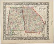
- "County Map of Georgia and Alabama."
- Creator:
- Mitchell, S. Augustus (Samuel Augustus), 1792-1868
- Publisher:
- Philadelphia: Augustus S. Mitchell, Jr.
- Date of Original:
- 1860
- Subject:
- Georgia--Maps
Alabama--Maps
Railroads--Alabama--Maps - Location:
- United States, Alabama, 32.75041, -86.75026
United States, Georgia, 32.75042, -83.50018 - Medium:
- maps (documents)
- Type:
- Still Image
- Format:
- image/jpeg
- Description:
- In: Unidentified atlas, 29.
Scale [ca. 1:2,661,120] (W 88°30'--W 80°45'/N 35°00'--N 30°15').
Shows counties, cities and towns.
"Entered into Act of Congress, in the year 1860 by S. Augustus Mitchell, Jr. in the Clerks Office of the U.S. for the Eastern District of Pennsylvania."
In lower right margin: 29.
Decorative borders.
From an unidentified Mitchell atlas. - External Identifiers:
- Metadata URL:
- https://vault.georgiaarchives.org/digital/collection/hmf/id/12
- Language:
- eng
- Extent:
- 15.25 x 12.5
- Original Collection:
- hmf0150, Historic Maps, Surveyor General, RG 3-8-65, Georgia Archives
Historic Maps, Surveyor General, RG 3-8-65, Georgia Archives - Holding Institution:
- Georgia Archives
- Rights:
-
