- Collection:
- Georgia Historical Markers
- Title:
- The Blackshear Road historical marker
- Creator:
- Seibert, David, 1941-2020
- Date of Original:
- 1996/2014
- Subject:
- Historical markers--Georgia--Dodge County
Roads--Georgia - Location:
- United States, Georgia, Dodge County, Eastman, 32.19767, -83.17765
- Medium:
- photographs
- Type:
- Still Image
- Format:
- image/jpeg
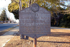
- Description:
- Location: U.S. 23 in Eastman at the American Legion Post
Text of marker: "THE BLACKSEAR ROAD. At this point the highway was originally known as the Blackshear Road. It was planned and cut out, in 1815, by Major Elijah Blackshear and a company of Georgia Volunteer Militia. This road gained fame as the alternative route used by General David Blackshear during his defense of the threatened invasion of the Southern border of Georgia in the War of 1812." - External Identifiers:
- Metadata URL:
- https://dlg.usg.edu/record/dlg_ghm_the-blackshear-road
- Digital Object URL:
- http://dlg.galileo.usg.edu/do:dlg_ghm_the-blackshear-road
- Language:
- eng
- Rights Holder:
- Copyright held by David Seibert. Please contact markers@davidseibert.com about commercial reproduction and use
- Holding Institution:
- Digital Library of Georgia
- Rights:
-
