- Collection:
- Georgia Historical Markers
- Title:
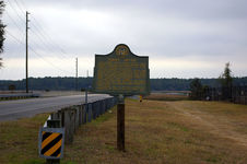
- Point Peter historical marker
- Creator:
- Seibert, David, 1941-2020
- Date of Original:
- 1996/2014
- Subject:
- Historical markers--Georgia--Camden County
Fortification--Georgia
United States--History--Revolution, 1775-1783--Battlefields - Location:
- United States, Georgia, Camden County, St. Marys, 30.73051, -81.54649
- Medium:
- photographs
- Type:
- Still Image
- Format:
- image/jpeg
- Description:
- Location: Point Peter Rd. near intersection with Osborne St. Marys
Text of marker: "POINT PETER. East of here, at the junction of Peter Creek and St. Mary's river, the British built Fort Tonyn in 1776; controlling the southern part of the colony of Georgia for two years. In 1778, American Revolutionary forces, both land and water, forced evacuation of the exposed position. The English retreated N.W. along North river into Pagan Creek Plantation, home of the Tories, Charles and Jermyn Wright, brothers of Royal Governor James Wright. On high land along Alligator (now Borell) creek, they built log and sand breastworks and repulsed the American Cavalry under Col. Elijah Clark. It appears that in the War of 1812, Fort Pickering was built on the Fort Tonyn site. 020-8 GEORGIA HISTORICAL COMMISSION 1953" - External Identifiers:
- Metadata URL:
- https://dlg.usg.edu/record/dlg_ghm_point-peter
- Digital Object URL:
- http://dlg.galileo.usg.edu/do:dlg_ghm_point-peter
- Language:
- eng
- Rights Holder:
- Copyright held by David Seibert. Please contact markers@davidseibert.com about commercial reproduction and use
- Holding Institution:
- Digital Library of Georgia
- Rights:
-
