- Collection:
- Georgia Historical Markers
- Title:
- Old Savannah Road historical marker
- Creator:
- Jackson, Edwin L.
- Date of Original:
- 1996/2014
- Subject:
- Historical markers--Georgia--Jefferson County
Roads--Georgia - Location:
- United States, Georgia, Jefferson County, 33.05484, -82.41815
- Medium:
- photographs
- Type:
- Still Image
- Format:
- image/jpeg
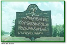
- Description:
- Location: U.S. 1 in Jefferson County, just north of the Emanuel County line
Text of marker: "OLD SAVANNAH ROAD. The highway bearing westward is the Old Savannah Road, a pioneer trace from Savannah to the western frontier and Indian country. From here it led by Riddleville and Sandersville to the Rock Landing on the Oconee, below Milledgeville. There it joined the main Lower Creek Trading Path from Augusta to the Creek Indians. It is believed General Oglethorpe travelled this way in 1739 on his trip to treat with the Indians at Coweta Town, on the Chattahoochee River, below Columbus in present Alabama. He left from Mt. Pleasant on the Savannah River and probably entered this route just west of Paramore Hill. 053-8 GEORGIA HISTORICAL COMMISSION 1963" - External Identifiers:
- Metadata URL:
- https://dlg.usg.edu/record/dlg_ghm_old-savannah-road3
- Digital Object URL:
- http://dlg.galileo.usg.edu/do:dlg_ghm_old-savannah-road3
- Language:
- eng
- Holding Institution:
- Digital Library of Georgia
- Rights:
-
