- Collection:
- Georgia Historical Markers
- Title:
- Old River Road historical marker
- Creator:
- Seibert, David, 1941-2020
- Date of Original:
- 1996/2014
- Subject:
- Historical markers--Georgia--Bulloch County
Roads--Georgia - Location:
- United States, Georgia, Bulloch County, 32.39681, -81.74318
- Medium:
- photographs
- Type:
- Still Image
- Format:
- image/jpeg
- Description:
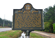
- Location: Ga. 119 1/4 mi. N.E. of junction with 119-C near Ivanhoe
Text of marker: "OLD RIVER ROAD. The highway crossing here is the Old River Road, one of the earliest white man's routes west of the Ogeechee. The State authorized the opening of this portion of the old thoroughfare in 1777. It followed the course of an Indian trail that led to the Rock Landing on the Oconee, below today's Milledgeville. There it intersected the noted Lower Creek Trading Path from Augusta to the Creek Indians of western Georgia. When Milledgeville became the capital, the old route became a leading vehicular way from Savannah to that place. Most of this pioneer trace continues in daily use. 016-4 GEORGIA HISTORICAL COMMISSION 1956" - External Identifiers:
- Metadata URL:
- https://dlg.usg.edu/record/dlg_ghm_old-river-road1
- Digital Object URL:
- http://dlg.galileo.usg.edu/do:dlg_ghm_old-river-road1
- Language:
- eng
- Rights Holder:
- Copyright held by David Seibert. Please contact markers@davidseibert.com about commercial reproduction and use
- Holding Institution:
- Digital Library of Georgia
- Rights:
-
