- Collection:
- Georgia Historical Markers
- Title:
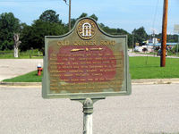
- Old Quaker Road historical marker
- Creator:
- Seibert, David, 1941-2020
- Date of Original:
- 1996/2014
- Subject:
- Historical markers--Georgia--Burke County
Roads--Georgia - Location:
- United States, Georgia, Burke County, Waynesboro, 33.08987, -82.01567
- Medium:
- photographs
- Type:
- Still Image
- Format:
- image/jpeg
- Description:
- Location: Located near the junction of U.S. 25 and Ga. 24, just south of Waynesboro
Text of marker: "OLD QUAKER ROAD. The highway bearing left is the Old Quaker road, on of Georgia's earliest vehicular highways. It was opened about 1769 to provide a direct way from Savannah to a Quaker settlement centering around Wrightsboro in today's upper McDuffie County. The Quaker road was one of the longest and most important routes of colonial Georgia. Much of the original way remains in use. 017-2 GEORGIA HISTORICAL COMMISSION 1954" - External Identifiers:
- Metadata URL:
- https://dlg.usg.edu/record/dlg_ghm_old-quaker-road1
- Digital Object URL:
- http://dlg.galileo.usg.edu/do:dlg_ghm_old-quaker-road1
- Language:
- eng
- Rights Holder:
- Copyright held by David Seibert. Please contact markers@davidseibert.com about commercial reproduction and use
- Holding Institution:
- Digital Library of Georgia
- Rights:
-
