- Collection:
- Georgia Historical Markers
- Title:
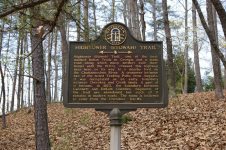
- Hightower (Etowah) Trail historical marker
- Creator:
- Seibert, David, 1941-2020
- Date of Original:
- 1996/2014
- Subject:
- Historical markers--Georgia--Fulton County
Trade routes--Georgia
Boundaries - Location:
- United States, Georgia, Fulton County, 33.79025, -84.46702
- Medium:
- photographs
- Type:
- Still Image
- Format:
- image/jpeg
- Description:
- Location: Hightower Trail, west of Roswell Road
Text of marker: "HIGHTOWER (ETOWAH) TRAIL. Hightower (Etowah) Trail, of the best marked Indian Trails in Georgia and a main road along which many settlers built their homes until the 1840's, crossed this highway near here on its way to a nearby ford on the Chattahoochee River. A crossover between two of the noted Trading Paths from Augusta, it was recognized as an early boundary between Cherokee and Creek lands. A part of it became, in 1823, the boundary between Gwinnett and DeKalb Counties. Segments of the trail are abandoned but much of it remains in modern roads. The name is believed to come from the Cherokee, Ita-Wa. 060-114 GEORGIA HISTORICAL COMMISSION 1957" - External Identifiers:
- Metadata URL:
- https://dlg.usg.edu/record/dlg_ghm_hightower-etowah-trail1
- Digital Object URL:
- http://dlg.galileo.usg.edu/do:dlg_ghm_hightower-etowah-trail1
- Language:
- eng
- Rights Holder:
- Copyright held by David Seibert. Please contact markers@davidseibert.com about commercial reproduction and use
- Holding Institution:
- Digital Library of Georgia
- Rights:
-
