- Collection:
- Georgia Historical Markers
- Title:
- French's Line historical marker
- Creator:
- Seibert, David, 1941-2020
- Date of Original:
- 1996/2014
- Subject:
- Historical markers--Georgia--Fulton County
- Location:
- United States, Georgia, Fulton County, Atlanta, 33.749, -84.38798
- Medium:
- photographs
- Type:
- Still Image
- Format:
- image/jpeg
- Description:
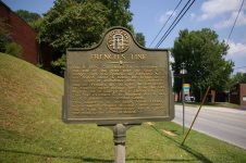
- Location: Chattahochee Ave. and Carroll Dr., Atlanta
Text of marker: "FRENCH'S LINE. July 9, 1864. Confederate forces withdrew to this side of the river near the State R.R. bridge. Gen. S.G. French's div. (Stewart's A.C.) was posted above & below the bridge as a rear guard of Johnston's Army of Tennessee. July 18. French's div occupied the left sector of Atlanta's outer defense line - from the old Marietta Rd. at Casey's Hill to DeFoors Fy. Rd. This line extended E. to Highland Ave. & was S. of & parallel to Peachtree Creek. This marker is at the point where French's entrenchments crossed Woodall Creek. Casey's Hill is .9 mi. W.; Chattahoochee Ave. is a post-war road to the river at Bolton. 060-67 GEORGIA HISTORIC MARKER 1988" - External Identifiers:
- Metadata URL:
- https://dlg.usg.edu/record/dlg_ghm_frenchs-line
- Digital Object URL:
- http://dlg.galileo.usg.edu/do:dlg_ghm_frenchs-line
- Language:
- eng
- Rights Holder:
- Copyright held by David Seibert. Please contact markers@davidseibert.com about commercial reproduction and use
- Holding Institution:
- Digital Library of Georgia
- Rights:
-
