- Collection:
- J. Kyle Spencer Map Collection
- Title:
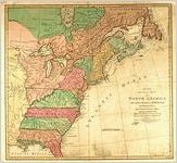
- A New and Accurate Map Of North America, drawn from the famous Mr. D'Anville with improvements from the best English maps; and engraved by R. W. Seale; Also the new divisions according to the late Treaty of Peace by Peter Bell geor. Printed for Carington Bowles, Map & printseller, No. 69 in St. Pauls Church Yard. London. Published January 1771.
- Creator:
- Bell, Peter (Geographer)
- Contributor to Resource:
- Anville, Jean Baptiste Bourguignon d', 1697-1782
- Publisher:
- J. Kyle Spencer Map Collection (MC 136), Columbus State University Archives, Columbus, Georgia
- Date of Original:
- 1771
- Subject:
- Early maps
Devices (Heraldry)
Cardinal points
Maps
Cartouches, Ornamental (Decorative arts) - Location:
- Canada, 60.10867, -113.64258
North America, 46.07323, -100.54688 - Medium:
- maps (documents)
- Type:
- Still Image
- Format:
- image/jpeg
- Description:
- Map of North America. As an active London engraver and map publisher in that period, Seale's numerous works depicted various areas of the British empire, other countries, and the world. Many cartographers who depicted North America in the second half of the 18th century relied on Jean Baptiste B. d'Anville's 1755 map. D'Anville showed an expanded French empire that the English re-interpreted as encroachments on British territory.
- External Identifiers:
- Metadata URL:
- http://digitalarchives.columbusstate.edu/items/show/48
- Extent:
- 47 x 51 cm
- Holding Institution:
- Columbus State University. Archives
- Rights:
-
