- Collection:
- J. Kyle Spencer Map Collection
- Title:
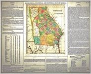
- "Geographical, Historical, And Statistical Map Of Georgia." Drawn by F. Lucas, Jr. Engrd. by J. Yeager. A Complete Historical, Chronological, And Geographical American Atlas, . . . To The Year 1822 . . . T. H. Palmer, Printer. Published by H. C. Carey & I. Lea, Philadephia, 1822.
- Creator:
- Lucas, Fielding, Jr., 1781-1854
- Publisher:
- J. Kyle Spencer Map Collection (MC 136), Columbus State University Archives, Columbus, Georgia
- Date of Original:
- 1822
- Subject:
- Early maps
Devices (Heraldry)
Cardinal points
Maps
Georgia
Indians of North America
Cartouches, Ornamental (Decorative arts) - Location:
- United States, Georgia, 32.75042, -83.50018
- Medium:
- maps (documents)
- Type:
- Still Image
- Format:
- image/png
- Description:
- This was the first American atlas modeled on that of Le Sage's volume published in Florence, Italy (1806) that focused on European countries and world history. Carey and Lea extended this concept to the U.S. states and the countries of Latin America. Fielding Lucas drew this and several other maps in this volume. The Georgia data appears to be based on the 1820 census and includes statistics and information about population, climate, education, history, government, etc. As this 1822 maps shows, the Cherokees still retained their land in the northwest corner of Georgia, while the Lower Creeks owned a strip of tribal property between the Flint and Chattahoochee Rivers. Both groups lost their land during the two ensuing decades.
- External Identifiers:
- Metadata URL:
- http://digitalarchives.columbusstate.edu/items/show/35
- Extent:
- 45 x 56 cm
- Holding Institution:
- Columbus State University. Archives
- Rights:
-
