- Collection:
- New Georgia Encyclopedia
- Title:
- Columbus Fall Line
- Creator:
- Gore, Pamela J. W.
- Date of Original:
- 1708/2022
- Subject:
- Rivers--Georgia--Columbus
Rocks--Georgia--Columbus
Geology--Georgia--Columbus
Trails--Georgia--Columbus
Sidewalks--Georgia--Columbus
Trees--Georgia--Columbus - Location:
- United States, Georgia, Muscogee County, Columbus, 32.46098, -84.98771
- Medium:
- color photographs
- Type:
- Still Image
- Format:
- image/jpeg
- Description:
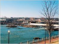
- One end of Georgia's fall line, which marks the boundary between the hard rocks of the Piedmont geologic province and the softer rocks of the Coastal Plain, is located in Columbus. Marked by waterfalls and rapids, the fall line stretches across the state to Augusta.
Photograph of one end of Georgia's fall line, located in Columbus, Georgia. This marks the boundary between the hard rocks of the Piedmont geologic province and the softer rocks of the Coastal Plain. A walkway lines the blue water of the river. Marked by waterfalls and rapids, the fall line stretches across the state to Augusta. - Metadata URL:
- https://www.georgiaencyclopedia.org/articles/geography-environment/fall-line/m-10629/
- Rights Holder:
- Photograph by Pamela J. W. Gore
- Additional Rights Information:
- Please contact holding institution for information regarding use and copyright status.
- Original Collection:
- http://www.georgiaencyclopedia.org/articles/science-medicine/coastal-plain-geologic-province
Forms part of: New Georgia Encyclopedia - Holding Institution:
- New Georgia Encyclopedia (Project)
- Rights:
-
