- Collection:
- New Georgia Encyclopedia
- Title:
- Ogeechee River Watershed
- Date of Original:
- 1708/2022
- Subject:
- Rivers--Georgia
Land use--Georgia
Land use mapping--Georgia
Ogeechee River (Ga.)
Watersheds--Georgia
Georgia--Maps - Location:
- United States, Georgia, 32.75042, -83.50018
- Medium:
- land use maps
maps (documents) - Type:
- Still Image
- Format:
- image/jpeg
- Description:
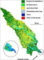
- The Ogeechee River, one of only forty-two free-flowing rivers in the United States longer than 200 kilometers, drains from the eastern part of Georgia to the Atlantic Ocean.
This map of the Ogeechee River watershed in Georgia shows land use and land cover in the Ogeechee watershed, which runs through the Georgia Piedmont into the Coastal Plain. The key on the upper right indicates the colors used in the map to represent different types of land use and land cover. A detailed image at the bottom gives a closer view of the estuarine section of the Ogeechee River. - External Identifiers:
- Metadata URL:
- https://www.georgiaencyclopedia.org/articles/geography-environment/river-basins/m-10420/
- Rights Holder:
- Courtesy of Georgia Rivers LMER
- Additional Rights Information:
- Please contact holding institution for information regarding use and copyright status.
- Original Collection:
- Forms part of: New Georgia Encyclopedia
- Holding Institution:
- New Georgia Encyclopedia (Project)
- Rights:
-
