- Collection:
- Works Progress Administration of Georgia Atlanta Maps
- Title:
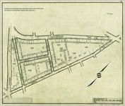
- Atlanta Cadastral Survey, Tax District 9, Sheet 13
- Creator:
- United States. Works Progress Administration of Georgia
- Date of Original:
- 1937
- Subject:
- Real property--Georgia--Atlanta--Maps
- Location:
- United States, Georgia, Fulton County, Atlanta, 33.749, -84.38798
- Medium:
- maps (documents)
- Type:
- Still Image
- Format:
- image/jp2
- Description:
- Atlanta Cadastral Survey features property lines, curb lines, city limit lines, tax district lines, undeveloped streets, concrete and masonry walls, building lines, hedges, fences, railroads, streetcar tracts, streams, trees along property lines, iron pins, wooden stakes, rock and concrete monuments, fire plugs, churches, schools, building and house numbers, and railroad right-of-ways. The Atlanta Cadastral Survey is divided into tax district blocks.
Original copies are held at the City of Atlanta Department of Watershed Management, Office of Engineering Services, Geographic Information Systems map collection.
Scale: 1:146
Cadastral - Local Identifier:
- acs_wpa_td9_sheet13
- External Identifiers:
- Metadata URL:
- http://digitalcollections.library.gsu.edu/cdm/ref/collection/wpamaps/id/164
- Language:
- eng
- Bibliographic Citation (Cite As):
- Cite as: acs_wpa_td9_sheet13, Works Progress Administration of Georgia Atlanta Maps, Georgia State University
- Original Collection:
- Map Collection, Atlanta Department of Watershed Management.
- Holding Institution:
- Atlanta (Ga.). Department of Watershed Management
- Rights:
-
