- Collection:
- Works Progress Administration of Georgia Atlanta Maps
- Title:
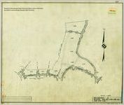
- Atlanta Cadastral Survey, Tax District 2, Sheet 102
- Creator:
- United States. Works Progress Administration of Georgia
- Date of Original:
- 1938
- Subject:
- Real property--Maps
- Location:
- United States, Georgia, Fulton County, Atlanta, 33.749, -84.38798
- Medium:
- maps (documents)
- Type:
- Still Image
- Format:
- image/jp2
- Description:
- Atlanta Cadastral Survey features property lines, curb lines, city limit lines, tax district lines, undeveloped streets, concrete and masonry walls, building lines, hedges, fences, railroads, streetcar tracts, streams, trees along property lines, iron pins, wooden stakes, rock and concrete monuments, fire plugs, churches, schools, building and house numbers, and railroad right-of-ways. The Atlanta Cadastral Survey is divided into tax district blocks.
Original copies are held at the City of Atlanta Department of Watershed Management, Office of Engineering Services, Geographic Information Systems map collection.
Cadastral
1:100 - Local Identifier:
- acs_wpa_td2_sheet102
- External Identifiers:
- Metadata URL:
- http://digitalcollections.library.gsu.edu/cdm/ref/collection/wpamaps/id/0
- Language:
- eng
- Additional Rights Information:
- The organization that has made the Item available believes that the Item is in the Public Domain under the laws of the United States, but a determination was not made as to its copyright status under the copyright laws of other countries. The Item may not be in the Public Domain under the laws of other countries. Please refer to the organization that has made the Item available for more information.
- Bibliographic Citation (Cite As):
- acs_wpa_td2_sheet102, Works Progress Administration of Georgia Atlanta Maps, Georgia State University
- Original Collection:
- Works Progress Administration of Georgia Atlanta Maps
- Holding Institution:
- Georgia State University. Special Collections
- Rights:
-
