- Collection:
- Historic Maps (Georgia Archives)
- Title:
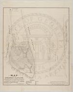
- Map representing Dungenness Plantation, situated on the South end of Missoe Island, known as Cumberland, in Camden County, Georgia
- Creator:
- Tebeau, John R.
- Publisher:
- Philadelphia: Lehman & Bolton, Lith., ca. 1878.
- Date of Original:
- 1878
- Subject:
- Cumberland Island (Ga.)--Maps
- Location:
- United States, Georgia, Camden County, Cumberland Island, 30.85107, -81.44843
- Medium:
- maps (documents)
- Type:
- Still Image
- Format:
- image/jpeg
- Description:
- Resurveyed September 5, 1878. John R. Tebeau, Surveyor, Chatham County, Georgia. This is a map of the property of the estate of Mrs. Eliza H. Molyneux.
- External Identifiers:
- Metadata URL:
- https://vault.georgiaarchives.org/digital/collection/hmf/id/48
- Language:
- eng
- Extent:
- 19 x 24
- Original Collection:
- omf023, Carnegie Estate Records of Cumberland Island, ac. 1969-0501M, Georgia Archives
- Holding Institution:
- Georgia Archives
- Rights:
-
