- Collection:
- Historic Maps (Georgia Archives)
- Title:
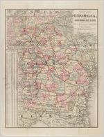
- New map of Georgia, showing railroads, congressional districts and counties
- Creator:
- Stebbins, Henry S.
- Publisher:
- Chicago : Henry S. Stebbins, 1881
- Date of Original:
- 1881
- Subject:
- Georgia--Maps
- Location:
- United States, Georgia, 32.75042, -83.50018
- Medium:
- maps (documents)
- Type:
- Still Image
- Format:
- image/jpeg
- Description:
- Prepared expressly for the State Railroad Commission by Henry S. Stebbins, Map Engraver & Publisher.
Scale: 19 miles = 1 inch - External Identifiers:
- Metadata URL:
- https://vault.georgiaarchives.org/digital/collection/hmf/id/45
- Language:
- eng
- Extent:
- 17 x 22
- Original Collection:
- omf024, Annual Reports of Railroads, Express Companies, and Street Railways, Georgia Public Service Commission, 17-2-9, Georgia Archives
- Holding Institution:
- Georgia Archives
- Rights:
-
