- Collection:
- Historic Maps (Georgia Archives)
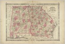
- Title:
- "Johnson's Georgia and Alabama."
- Creator:
- Johnson, A. J. (Alvin Jewett), 1827-1884
- Publisher:
- New York: Johnson and Ward, 1863.
- Date of Original:
- 1863
- Subject:
- Alabama--Maps
Georgia--Maps - Location:
- Southeastern United States, 34.658488, -84.73441
- Medium:
- maps (documents)
- Type:
- Still Image
- Format:
- image/jpeg
- Description:
- In: Unidentified atlas, 41-42.
"Longitude West from Washington."
"Entered according to Act of Congress in the year 1863 by A. J. Johnson in the Clerks Office of the District County of the United States for the Southern District of New York."
Scale ca. 1:1,600,000 (W 89°10'--W 80°30'/N 35°--N 30°).
Decorative border. Map continues beyond borders of Georgia and Alabama
Plate 41-42 in his New illustrated family atlas of the World, 1864
The counties are colored separately. - External Identifiers:
- Metadata URL:
- https://vault.georgiaarchives.org/digital/collection/hmf/id/29
- Language:
- eng
- Extent:
- 26.25 x 18
- Original Collection:
- hmf0079, Historic Maps, Surveyor General, RG 3-8-65, Georgia Archives
Historic Maps, Surveyor General, RG 3-8-65, Georgia Archives - Holding Institution:
- Georgia Archives
- Rights:
-
