- Collection:
- Historic Maps (Georgia Archives)
- Title:
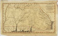
- "Georgia, from the latest Authorities."
- Creator:
- Wayland, Reid & Smith
- Contributor to Resource:
- Reid, John, publisher
Tanner, Benjamin, 1775-1848
Winterbotham, William, 1763-1829 - Publisher:
- New York: J. Reid, [1796].
- Date of Original:
- 1796
- Subject:
- Southern States--Maps--Early works to 1800
Tennessee--Maps--Early works to 1800 - Location:
- United States, Georgia, 32.75042, -83.50018
- Medium:
- maps (documents)
- Type:
- Still Image
- Format:
- image/jpeg
- Description:
- Scale [ca. 1:3,000,000] (W 83°22'--W 78°31'/N 35°13'--N 32°00').
Scale [ca. 1:1,900,800] (W 83°22'--W 78°31'/N 35°13'--N 32°00').
Benjamin Tanner, sculpt., N. Y.
Relief shown pictorially
Prime meridians: Philadelphia and London - External Identifiers:
- Metadata URL:
- https://vault.georgiaarchives.org/digital/collection/hmf/id/26
- Language:
- eng
- Extent:
- 16.25 x 10
- Original Collection:
- hmf0035, Historic Maps, Surveyor General, RG 3-8-65, Georgia Archives
Historic Maps, Surveyor General, RG 3-8-65, Georgia Archives - Holding Institution:
- Georgia Archives
- Rights:
-
