- Collection:
- Historic Maps (Georgia Archives)
- Title:
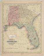
- "Georgia, Florida, and Alabama."
- Creator:
- Wells, J.
- Contributor to Resource:
- McNally, Francis
Sherman, George E., 1810 or 1811- - Publisher:
- New York: [McNally, 1854].
- Date of Original:
- 1854
- Subject:
- Georgia--Maps
Florida--Maps
Alabama--Maps - Location:
- Southeastern United States, 34.658488, -84.73441
- Medium:
- maps (documents)
- Type:
- Still Image
- Format:
- image/jpeg
- Description:
- Drawn by J. Wells. Engraved by George E. Sherman, New York. In: MCNALLY'S SYSTEM OF GEOGRAPHY, Map No. 11.
From the book: McNally's system of Geography, Map No. 11
Drawn by J. Wells, N.Y
Eng. by Geo. E. Sherman, N.Y - External Identifiers:
- Metadata URL:
- https://vault.georgiaarchives.org/digital/collection/hmf/id/25
- Language:
- eng
- Extent:
- 9.5 x 12
- Original Collection:
- hmf0072, Historic Maps, Surveyor General, RG 3-8-65, Georgia Archives
Historic Maps, Surveyor General, RG 3-8-65, Georgia Archives - Holding Institution:
- Georgia Archives
- Rights:
-
