- Collection:
- County Maps
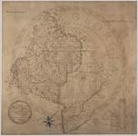
- Title:
- Baldwin County Map
- Publisher:
- Milledgeville, Ga.: N. C. Barnett, Secretary of State, 1867.
- Date of Original:
- 1867
- Subject:
- Baldwin County (Ga.)--Maps
- Location:
- United States, Georgia, Baldwin County, 33.06928, -83.24959
- Medium:
- maps (documents)
- Type:
- Still Image
- Format:
- image/jpeg
- Description:
- "The above is an accurate Map of Baldwin County as taken from the District Maps. The 'Head Rights' portion from Butts Map 1859. Made in accordance with an Act of the Genl. Assembly, assented to December 12, 1866."B. A. White, Topographer.
- External Identifiers:
- Metadata URL:
- http://vault.georgiaarchives.org/cdm/ref/collection/cmf/id/8
- Language:
- eng
- Extent:
- 26 inches x 25.7 inches
- Original Collection:
- County Maps, Surveyor General, RG 3-9-66, Georgia Archives
- Holding Institution:
- Georgia Archives
- Rights:
-
