- Collection:
- County Maps
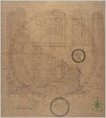
- Title:
- "A Map of Dawson Co. by J. A. Green."
- Publisher:
- Milledgeville, Ga.: N. C. Barnett, Secretary of State, 1866.
- Date of Original:
- 1866
- Subject:
- Dawson County (Ga.)--Maps
- Location:
- United States, Georgia, Dawson County, 34.4443, -84.17064
- Medium:
- maps (documents)
- Type:
- Still Image
- Format:
- image/jpeg
- Description:
- "The above is an accurate Map of Dawson County made in accordance with an Act of the General Assembly of the State of Georgia assented to Dec. 12th 1866." James A. Green, Topographer.
- External Identifiers:
- Metadata URL:
- http://vault.georgiaarchives.org/cdm/ref/collection/cmf/id/219
- Language:
- eng
- Extent:
- 31.25 inches x 35 inches
- Original Collection:
- County Maps, Surveyor General, RG 3-9-66, Georgia Archives
- Holding Institution:
- Georgia Archives
- Rights:
-
