- Collection:
- Georgia Historical Markers
- Title:
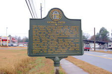
- Uchee Path historical marker
- Creator:
- Seibert, David, 1941-2020
- Date of Original:
- 1996/2014
- Subject:
- Historical markers--Georgia--leckley County
Trails--Georgia - Location:
- United States, Georgia, Bleckley County, Cochran, 32.38683, -83.35461
- Medium:
- photographs
- Type:
- Still Image
- Format:
- image/jpeg
- Description:
- Location: Ga. 26 at Eighth St., north edge of Cochran
Text of marker: "UCHEE PATH. This highway coincides closely with a segment of a noted east-west Indian route called the Lower Uchee Path. Beginning at Old Town on the Ogeechee, the trail led this way by Carr's Shoals, on the Oconee, above Dublin, thence via Cochran, Hawkinsville and Montezuma to Uchee Town on the Chattahoochee River, in Russell County, Alabama. At the Ogeechee, the trail connected with various paths leading from former Uchee settlements on the middle Savannah River. The route was opened around 1729 when the Uchees began removing to the town on the Chattahoochee River. This way paralleled another trail to the northward which was known as the Upper Uchee Path. 012-4 GEORGIA HISTORICAL COMMISSION 1961" - External Identifiers:
- Metadata URL:
- https://dlg.usg.edu/record/dlg_ghm_uchee-path
- Digital Object URL:
- http://dlg.galileo.usg.edu/do:dlg_ghm_uchee-path
- Language:
- eng
- Rights Holder:
- Copyright held by David Seibert. Please contact markers@davidseibert.com about commercial reproduction and use
- Holding Institution:
- Digital Library of Georgia
- Rights:
-
