- Collection:
- Georgia Historical Markers
- Title:
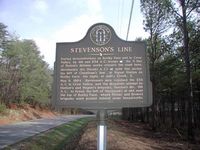
- Stevenson's Line historical marker
- Creator:
- Hooks, Byron
- Date of Original:
- 1996/2014
- Subject:
- Historical markers--Georgia--Whitfield County
United States--History--Civil War, 1861-1865--Battlefields - Location:
- United States, Georgia, Whitfield County, 34.80561, -84.96722
- Medium:
- photographs
- Type:
- Still Image
- Format:
- image/jpeg
- Description:
- Location: 50 yds. S. of Polar Church Rd. .1 mile E. of Crow Valley Rd.
Text of marker: "STEVENSON'S LINE. During demonstrations on Rocky Face and in Crow Valley, by 4th and 23rd A.C. troops [Federal], the N. line of Dalton's defense works crossed the road here. Stevenson's div. (Hood's A.C.) [Confederate] held this sector, his left at Cheatham's line, at Signal Station on Rocky Face; his right at Ault's Creek, E. May 9, 1864. Stevenson's men repulsed the 23d A.C. in Crow Valley, and the desperate attempt by Harker's and Wagner's brigade, Newton's div.., 4th Army Corps. to break the left of Stevenson at and near the top of Rocky Face, where Pettus' and Brown's brigades were posted behind stone breastworks that are still there. 155-20 GEORGIA HISTORICAL COMMISSION 1985" - External Identifiers:
- Metadata URL:
- https://dlg.usg.edu/record/dlg_ghm_stevensons-line
- Digital Object URL:
- http://dlg.galileo.usg.edu/do:dlg_ghm_stevensons-line
- Language:
- eng
- Holding Institution:
- Digital Library of Georgia
- Rights:
-
