- Collection:
- Georgia Historical Markers
- Title:
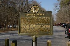
- Power's Ferry historical marker
- Creator:
- Seibert, David, 1941-2020
- Date of Original:
- 1996/2014
- Subject:
- Historical markers--Georgia--Cobb County
United States--History--Civil War, 1861-1865--Campaigns - Location:
- United States, Georgia, Cobb County, 33.94147, -84.57667
- Medium:
- photographs
- Type:
- Still Image
- Format:
- image/jpeg
- Description:
- Location: Chattahoochee Recreation Area parking area just north of I-285 crossing of river
Text of marker: "POWER'S FERRY. Established 1835 by James Power, (1790-1870). Maj. Gen. O. O. Howard's 4th A. C. (Army of the Cumberland) [US], moved from Vining's station to this vicinity July 9, 10, 1864. Newton's (2d) div. was diverted to Roswell to support Garrard's cav. Stanley's (1st) and Wood's (3d) camped 3 mi. N. near Soap Creek, July 10. Stanley crossed the Chattahoochee on Schofield's pontoon bridge at mouth of Soap Cr. and moved S. on the other side to cover Power's Ferry where Wood crossed on a pontoon bridge July 12. Newton, back from Roswell, crossed July 13. Stanley's and Newton's men built a trestle bridge at the upper island, July 14-16. 033-90 GEORGIA HISTORIC MARKER 1989" - External Identifiers:
- Metadata URL:
- https://dlg.usg.edu/record/dlg_ghm_powers-ferry
- Digital Object URL:
- http://dlg.galileo.usg.edu/do:dlg_ghm_powers-ferry
- Language:
- eng
- Rights Holder:
- Copyright held by David Seibert. Please contact markers@davidseibert.com about commercial reproduction and use
- Holding Institution:
- Digital Library of Georgia
- Rights:
-
