- Collection:
- Georgia Historical Markers
- Title:
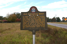
- Old Savannah Road historical marker
- Creator:
- Seibert, David, 1941-2020
- Date of Original:
- 1996/2014
- Subject:
- Historical markers--Georgia--Jefferson County
Roads--Georgia - Location:
- United States, Georgia, Jefferson County, 33.05484, -82.41815
- Medium:
- photographs
- Type:
- Still Image
- Format:
- image/jpeg
- Description:
- Location: U.S. 319/U.S. 221 about 1.5 miles S. of Bartow near Nails Creek
Text of marker: "OLD SAVANNAH ROAD. The highway crossing here is the Old Savannah Road, one of the earliest vehicular routes west of the Ogeechee River. It led from Savannah to the Rock Landing on the Oconee, below today's Milledgeville, along the course of a former trading path to the Creek Indians of western Georgia and eastern Alabama. It is believed General Oglethorpe traveled this part of the Indian trail in 1739 on his way to treat with the Indians at Coweta Town, on the Chattahoochee River below Columbus in present Alabama. Much of this pioneer thoroughfare remains in daily use. 081-9 GEORGIA HISTORICAL COMMISSION 1956" - External Identifiers:
- Metadata URL:
- https://dlg.usg.edu/record/dlg_ghm_old-savannah-road4
- Digital Object URL:
- http://dlg.galileo.usg.edu/do:dlg_ghm_old-savannah-road4
- Language:
- eng
- Rights Holder:
- Copyright held by David Seibert. Please contact markers@davidseibert.com about commercial reproduction and use
- Holding Institution:
- Digital Library of Georgia
- Rights:
-
