- Collection:
- Georgia Historical Markers
- Title:
- Old River Road historical marker
- Creator:
- Seibert, David, 1941-2020
- Date of Original:
- 1996/2014
- Subject:
- Historical markers--Georgia--Bryan County
Roads--Georgia - Location:
- United States, Georgia, Bryan County, Blitchton, 32.19715, -81.43789
- Medium:
- photographs
- Type:
- Still Image
- Format:
- image/jpeg
- Description:
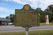
- Location: Located at the junction of U.S. 80 and U.S. 280 in Blitchton
Text of marker: "OLD RIVER ROAD. The highway northward is the Old River road, one of the earliest routes west of the Ogeechee and a leading way from Savannah to Georgia's western frontier. It followed an old Indian trial [trail] along the Ogeechee to a point west of Bartow, thence to the Rock landing on the Oconee River on the Oconee River below Milledgeville. There the trace intersected the main trail of the Lower Creek Trading Path from Augusta to the Creek Indians of western Georgia and eastern Alabama. Opening of this part of the road was authorized by the State in 1777. In time the route became an important vehicular thoroughfare from Savannah to Milledgeville. 015-5B GEORGIA HISTORIC MARKER 1996" - External Identifiers:
- Metadata URL:
- https://dlg.usg.edu/record/dlg_ghm_old-river-road
- Digital Object URL:
- http://dlg.galileo.usg.edu/do:dlg_ghm_old-river-road
- Language:
- eng
- Rights Holder:
- Copyright held by David Seibert. Please contact markers@davidseibert.com about commercial reproduction and use
- Holding Institution:
- Digital Library of Georgia
- Rights:
-
