- Collection:
- Georgia Historical Markers
- Title:
- Howard's Covered Bridge historical marker
- Creator:
- Seibert, David, 1941-2020
- Date of Original:
- 1996/2014
- Subject:
- Historical markers--Georgia--Oglethorpe County
Covered bridges--Georgia--Oglethorpe County - Location:
- United States, Georgia, Oglethorpe County, 33.88065, -83.0807
- Medium:
- photographs
- Type:
- Still Image
- Format:
- image/jpeg
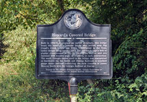
- Description:
- Location: Southern end of Chandler Silver Road [dirt road portion] and intersection with Cloud's Creek Road
Text of marker: "Howard's Covered Bridge. Built in 1904-05 to replace an earlier structure, this bridge bears the name of a pioneer family who settled near Big Cloud's Creek in the late 1700s. Constructed in the Town lattice design using convict labor, the 164-foot bridge's web of planks crisscrosses at 45- to 60-degree angles and are fastened with wooden pegs, or trunnels, at each intersection. The south Georgia timber used in the bridge was transported to Smithonia via the Smith and Dunlap Railroad, a standard gauge steam railroad connecting the fam complex of James Monroe Smith with the Georgia Railroad at Dunlap. 2000.13 Erected by The Georgia Historical Society, Georgia Department of Transportation, and the Federal Highway Administration 109-2" - External Identifiers:
- Metadata URL:
- https://dlg.usg.edu/record/dlg_ghm_howards-covered-bridge
- Digital Object URL:
- http://dlg.galileo.usg.edu/do:dlg_ghm_howards-covered-bridge
- Language:
- eng
- Rights Holder:
- Copyright held by David Seibert. Please contact markers@davidseibert.com about commercial reproduction and use
- Holding Institution:
- Digital Library of Georgia
- Rights:
-
