- Collection:
- Georgia Historical Markers
- Title:
- El Camino Real historical marker
- Creator:
- Logue, Joanie
- Date of Original:
- 1996/2014
- Subject:
- Historical markers--Georgia--Decatur County
Trade routes--Georgia - Location:
- United States, Georgia, Decatur County, Bainbridge, 30.9038, -84.57547
- Medium:
- photographs
- Type:
- Still Image
- Format:
- image/jpeg
- Description:
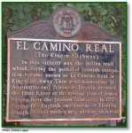
- Location: Located at the southeast corner of the Decatur County courthouse square, Bainbridge
Text of marker: "EL CAMINO REAL (The King's Highway). In this vicinity was the Indian trail which, during the period of Spanish occupation, became known as El Camino Real or King's Highway. This road, connecting St. Augustine and Pensacola, Florida, crossed the Flint River at the trading post of James Burges, near the present Bainbridge. In 1778, during the English occupation of Florida, Joseph Purcell made a map showing this road. [U.S. Works Progress Administration Marker]" - External Identifiers:
- Metadata URL:
- https://dlg.usg.edu/record/dlg_ghm_el-camino-real
- Digital Object URL:
- http://dlg.galileo.usg.edu/do:dlg_ghm_el-camino-real
- Language:
- eng
- Holding Institution:
- Digital Library of Georgia
- Rights:
-
