- Collection:
- Georgia Historical Markers
- Title:
- Dug Gap historical marker
- Creator:
- Seibert, David, 1941-2020
- Date of Original:
- 1996/2014
- Subject:
- Historical markers--Georgia--Whitfield County
- Location:
- United States, Georgia, Whitfield County, 34.80561, -84.96722
- Medium:
- photographs
- Type:
- Still Image
- Format:
- image/jpeg
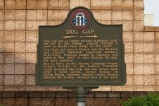
- Description:
- Location: Dug Gap Battle Rd. at the Visitors and Convention Center west of I-75
Text of marker: "DUG GAP 1 M. Dug Gap was so named because a pioneer road, cut out of the hillside, passed through a cleft in Rocky Face Ridge at this point. The road led east to Dalton and the Western and Atlantic Railroad, important military objectives. Federals sought in February and again in May, 1864, to pass through the gap, but were repulsed. May 8, 1864, as the Atlanta Campaign began, Geary's Division of the Federal Twentieth Corps attacked Dug Gap, but was driven back after a brisk action. Direct attacks on Dalton failing, Sherman flanked toward Resaca through the broken, wooded area to the west. 155-34 GEORGIA HISTORICAL COMMISSION 1959" - External Identifiers:
- Metadata URL:
- https://dlg.usg.edu/record/dlg_ghm_dug-gap1
- Digital Object URL:
- http://dlg.galileo.usg.edu/do:dlg_ghm_dug-gap1
- Language:
- eng
- Rights Holder:
- Copyright held by David Seibert. Please contact markers@davidseibert.com about commercial reproduction and use
- Holding Institution:
- Digital Library of Georgia
- Rights:
-
