- Collection:
- Georgia Historical Markers
- Title:
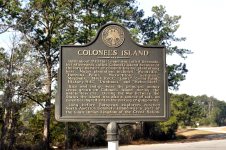
- Colonel's Island historical marker
- Creator:
- Seibert, David, 1941-2020
- Date of Original:
- 1996/2014
- Subject:
- Historical markers--Georgia--Liberty County
Colonel's Island (Ga.) - Location:
- United States, Georgia, Liberty County, 31.80723, -81.45626
- Medium:
- photographs
- Type:
- Still Image
- Format:
- image/jpeg
- Description:
- Location: Ga. 38 at Kings Road on Colonel's Island
Text of marker: "COLONEL'S ISLAND. Until about 1778 this island was called Colonel's Island because of the large number of colonels having plantations here. Major plantations included "Woodville," "Herron's Point," "Maxwellton," "Suligree," "Maybank," "Black Rock," "Laws," "Cedar Point," "Hickory Hill," "Dunham's," and "Melon Bluff." Rice and indigo were the principal money crops grown on Colonel's Island during the antebellum era. During the War Between the States the island was also a source of salt, an essential ingredient in the making of gunpowder. Long before European exploreres reached North America Colonel's Island was a part of the Guale Indian kingdom of the Creek Nation. Erected 1996 by the Liberty County Historical Society" - External Identifiers:
- Metadata URL:
- https://dlg.usg.edu/record/dlg_ghm_colonels-island
- Digital Object URL:
- http://dlg.galileo.usg.edu/do:dlg_ghm_colonels-island
- Language:
- eng
- Rights Holder:
- Copyright held by David Seibert. Please contact markers@davidseibert.com about commercial reproduction and use
- Holding Institution:
- Digital Library of Georgia
- Rights:
-
