- Collection:
- Georgia Historical Markers
- Title:
- Blair Line historical marker
- Creator:
- Hooks, Byron
- Date of Original:
- 1996/2014
- Subject:
- Historical markers--Georgia--Habersham County
Boundaries - Location:
- United States, Georgia, Habersham County, 34.63102, -83.53112
- Medium:
- photographs
- Type:
- Still Image
- Format:
- image/jpeg
- Description:
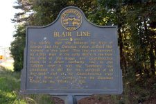
- Location: Ga. 115 just west of junction with Ga. 105
Text of marker: "BLAIR LINE. The historic Blair line between the State of Georgia and the Cherokee Nation crossed this highway at this point. This line was surveyed by James Blair in the early 1800's. It ran from the forks of the Soque and Chattahoochee rivers in a direct northerly line to the Tallulah river. It was the boundary line established in 1817 for the purchase of all the lands eat of the Chattahoochee river by the State of Georgia from the Cherokee Nation by the Treaty of 1818. 068-1 GEORGIA HISTORICAL COMMISSION 1953" - External Identifiers:
- Metadata URL:
- https://dlg.usg.edu/record/dlg_ghm_blair-line
- Digital Object URL:
- http://dlg.galileo.usg.edu/do:dlg_ghm_blair-line
- Language:
- eng
- Holding Institution:
- Digital Library of Georgia
- Rights:
-
