- Collection:
- Georgia Government Publications
- Title:
- Shales and brick clays of Georgia
- Creator:
- Smith, Richard Wellington, 1898-
- Publisher:
- Atlanta, Stein printing company
- Date of Original:
- 1931
- Subject:
- Shale
Clay--Georgia - Location:
- United States, Georgia, 32.75042, -83.50018
- Medium:
- state government records
government records - Type:
- Text
- Format:
- application/pdf
- Description:
- Bibliographical foot-notes
- External Identifiers:
- Call Number GA M500.G4 B1 no. 45
- Metadata URL:
- https://dlg.galileo.usg.edu/id:dlg_ggpd_s-ga-bm500-pg4-bb1-bno-p-b45
- Digital Object URL:
- https://dlg.galileo.usg.edu/do:dlg_ggpd_s-ga-bm500-pg4-bb1-bno-p-b45
- Language:
- eng
- Extent:
- xii, 348 p. incl. illus., tables, diagrs., x pl. (incl. front.) fold. col. map. 26 cm.
- Holding Institution:
- University of Georgia. Map and Government Information Library
- Rights:
-

GEOLOGICi\L SURVEY OF GEORGIA
S. W. McCALLIE, State Geologist
BULLETIN NO. 45
SHALES AND BRICK CLAYS
OF
GEORGIA
BY RICHARD W. SMITH
Assistant State Geologist
1931 STEIN PRINTING COMPANY
ATLANTA, GEORGIA
THE ADVISORY BOARD OF THE
Geological Survey of Georgia
IN THE YEAR 1931
(Ex-Officio) His ExcELLENCY, RICHARD B. RUSSELL, JR., Governor of Georgia
PRESIDENT oF THE BoARD
RoN. JOHN B. WILSON_______________________Secretary of State RoN. W. J. SPEER_______________________________State Treasurer HoN. W. B. HARRISON _____________________ Comptroller-General HoN. GEORGE M. NAPIER____________________Attorney-General RoN. EUGENE TALMADGE__________ Commissioner of Agriculture HoN. M. L. DUGGAN______________ Commissioner of Public Schools
m
LETTER OF TRANSMITTAL
GEOLOGICAL SURVEY OF GEORGIA,
ATLANTA, SEPTEMBER 1, 1931.
To His Excellency, RrcHARD B. RussELL, JR., Governor and President of the Advisory Board of the Geological Survey of Georgia. SrR: I have the honor to transmit herewith for publication the
report of Mr. Richard W. Smith, Assistant State Geologist, on the Shales and Brick Clays of Georgia. This report is the fourth report published by the State Geological Survey on the ceramic materials of the State. The first report, published in 1898, was confined entirely to the Cretaceous clays of south Georgia, the second report included not only the Cretaceous clays of south Georgia but gave a general description of the clays of the entire State, the third report was confined solely to the sedimentary 'clays of the Coastal Plain, including not only the Cretaceous clays but also the Eocene clays of the Tertiary age, whereas this report is confined to the shales and the brick clays of the entire State.
The large amount of information brought together in this report will 'be of great assistance in the expansion of the heavy clay products industry of Georgia that will accompany the industrial growth of the South.
Very respectfully yours,
S. W. McCALLIE,
State Geologist.
IV
TABLE OF CONTENTS
INTRODUCTION
Page
HISTORY 0 F THE INDUSTRy__------------------------------------------------------------------
PROPERTIES OF CLAYS________________________________________________________________________________
Classi:fication of clays ---------------------------------------------------------------------------------------Chemical properties-------------------------------------------------------------------------------------------Physical properties --------------------------------------------------------------------------------------------
Properties in the raw state____________________________________________________________________________ Properties in the fired state____________~-------------------------------------------------------------
1-4
5-18 5-6 6-10
IG-18 IG-13 13-18
FIELD AND LABORATORY METHODS FOR THIS REPORT________
Field methods---------------------------------------------------------------------------------------'------------Laboratory methods------------------------------------------------------------------------------------------Correlation of laboratory tests and plant practice----------------------------------------
19-27 19
19-25 25-27
USES OF RED-FIRING SHALES AND CLAYS--------------------------------------Building brick______-----___--------------------------------------------------------------------------___----------5 tructural tile______-----------------------------------------_____-------------------------------------------------Roofing tile_______-------------------------------------------------------------------------------------------------__ Quarry tile-----------------------------------------------------------------------------------------------------------Sewer pipe_--.------------------------------------------------------------------------------------------------------Drain tile-------------------------------------------------------------------------------------------------------------Conduits--------------------------------------------------------------------------------------------------------------Acid tower packing--------------------------------------------------------------------------------------------Paving brick_______--------------------------------------------------------------------------------------- __________ Light-weight aggregates__________________-------------------------------------------------------------------
27-44 27-30 8o-36
86 86-37 87-38 38-40
40 40 4o-41 41-44
. FACTORS AFFECTING THE UTILIZATION OF CLAY DEPOSITS 44-46
SHALE DEPOSITS OF GEORGIA
D ISTRIB UTI0 N--------------------------------------------------------------------------------------
GEOLOGY OF NORTHWEST GEORGIA____________________________________________________
Stratigraphic and p hysiographic historY--------------------------------------------------------Geological formations------------------------------------------------------------------------------------------
Cambrian system-------------------------------------------------------------------------------------------Ordovician or Cambrian systeiTL----------------------------------------------------------------Ordovician systenL----------------------------------------------------------------------------------------Silurian system_____------------------------------------------------------------------------------------------Devonian systeiTL------------------------------------------------------------------------------------------Mississippian or Devonian system------------------------------------------------------------Ca rboniferous systenL------------------------------------------------------------------------------------
47-49
5o-67 50-52 52-67 53-57 57-59 49-60 61-62 62-63
63 64-67
v
DISTRIBUTION AND DESCRIPTION OF DEPOSITS BY
COUNTIES------------------------------------------------------------------------------------------------------- 68-76 Polk County------------------------------------------------------------------------------------------------- 68-72 Floyd County....-------------------------------------------------------------------------------------------- 72-118 Ch_at tooga County..------------------------------------------------------------------------------------ 119-1~ Dade CountY------------------------------------------------------------------------------------------------- 122-136 Walker County--------------------------------------------------------------------------------------------- 136-172 Catoosa CountY---------------------------------------c---------------------------------------------------- 172-173 Whitfield CountY-------------------------------------------------------------------------------------- 173-193 Murray CountY---------------------------------------------------------------------------------------------- 193-11 Gordon County----------------------------------------------------------------------------------------------- 211-241 Bartow County------------------------------------------------------------------------------------------------ ~41-276
RESIDUAL AND. ALLUVIAL CLAYS
RESIDUAL CLAYS OF THE PIEDMONT PLATEAU---------------------------- 277-293
Origin..__-------------------------------------------------------------------------------------------------------------- 277-278
Distribution and description of deposits------------------------------------------------------ 278-293
Hall CountY--------------------------------------------------------------------------------------------------- 278-280
c Fulton CountY--------------------------------------------------------------------------------------------- 28D-284
Richmond CountY---------------------------------------------------------------------------------------- 284-291
Washington County------------------------------------------------------------------------------------- 291-293
Baldwin County~----------------------------------------------------------------------------------------
29.3
ALLUVIAL CLAYS OF THE FALL LINE------------------------------------------------ 293-325 Origin....------------------------------~-------------------------------------------------------------------------------- 2!)3-294 Distribution and description of deposits by districts---------------------------------- 294-325 Columbus District------------------------------------------------------------------------------------- ~94-300 Ma con District..----------------------------------------------~----------------------------------------------- 30D-308 Milledgeville District..------------------------------~------------------------------'----------------------- 308-315 Augusta District--------------------------------------------------~---------------------~------------------ 316-325
ALLUVIAL AND RESIDUAL CLAYS OF SOUTH GEORGIA_________ 36-330
FUTURE OF THE INDUSTRY......--------------------------------------------------------------- 331-333
APPENDIX NOTES ON THE OCCURRENCE OF BENTONITE IN GEORGIA_ 335-840
VI
LIST OF ILLUSTRATIONS
PLATES
F.A.CING P.A.GE
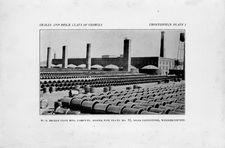
I. W. S. Dickey Clay Mfg. Company, Sewer Pipe Plant No. 11, near Flintstone, Walker County---------------------------------------------- (Frontispiece)
II. A. Shale pit, Oconee Clay and Shale Products Company, near Lavender Station, Floyd County. B. Outcrop of Red Mountain shale on the J. 0. McCallie property near Cenchat, Walker
CountY----------------------------------------------------------------------------------------------- 94
III. A. Overthrust fault in the Red Mountain formation, J. R. McFarland property, two miles south of Rossville, Walker County. 13. Alluvial clay pit of the Columbus Brick and Tile Company,
Columbus, M uscogee County---------------------------------------------------------- 166
IV. A. Face brick plant of the Chatsworth Clay Mfg. Company, Chatsworth, Murray County. B. Outcrop of Conasauga shale on the Davis and Street properties, Tennessee Highway near Ramhurst, Murray County-------------------------------------------.------------------ 196
V. A. Face brick plant of the Plainville Brick Company, Plainville, Gordon County. B. Shale pit of the Plainville Brick Company, Plainville, Gordon County--------------------------------------------------- 232
VI. A. Roofing tile plant of the B. Mi:ffiin Hood Company, Adairsville, Bartow County. B. Clay pit of the B. Mifflin Hood Com-
pany, Adairsville, Bartow County.....c------------------------------------------ 246
VII. A. North Clay pit of the Chattahoochee Brick Company, Chattahoochee, Fulton County. B. Scove brick kilns at the Chattahoochee Brick Company, Chattahoochee, Fulton
CountY------------------------------------------------------------------------------------------------- 282
VIII. A. Paving brick and sewer pipe plant of the Georgia Vitrified Brick Company, Campania, Columbia County. B. Main "shale" or weathered phyllite pit of the Georgia Vitrified Brick Com-
pany, Belair, Richmond CountY------------------------------------------------ 286
IX. A. Structural tile machine in operation, Cherokee Brick Company, Macon, Bibb County. B. Round down-draft kilns at the Cherokee Brick Company, Macon, Bibb CountY-------------------- 302
X. A. Open-air drying sheds, Merry Brothers Brick and Tile Company, Augusta, Richmond County. B. Haigh brick kilns, Merry Brothers Brick and Tile Company, Augusta, Rich-
mond County------------------------------------------------------------------------------------ 822
VII
TEXT FIGURES Page
1. Diagram of the Hue circle with the Munsell hue notation.......................... 23
2. Diagram showing Hue, Value, and Chroma in their relation to each other---------------------------------------------------------------------------------------------------------------- 24
8. The Appalachian Valley and the Lookout Plateau of Georgia__________________ 49
4. Structure section showing relation of hard rocks to Sand and Lookout Mountains------------------------------------------------------------------------------------------------------ 51
5. Graphs showing totai linear shrinkage, absorption, and modulus of rupture of: A. Rockmart slate from near Rockmart, Polk County. B. Floyd shale from the Romega Clay Products Company pit, West Rome, Floyd County. C. Clay from the Romega Clay Products Company pit, West Rome, Floyd County. D. Floyd shale from the W. S. Dickey Clay Mfg. Company pit, 3 miles west of Rome, Floyd CountY------------------------------------------------------------------------------------------------------------ 77
6. Graphs showing total linear shrinkage, absorption, and modulus of rupture of: A. Floyd shale from the Thomas Berry property, Berryhill Station, Floyd County. B. Residual clay from the Thomas Berry property, Berryhill Station, Floyd County.' C. Floyd shale from the Berryhill Estate, 7 miles northwest of Rome, Floyd County. D. Floyd shale from the S. Levinson property, 8 miles northwest of Rome, Floyd CountY-------------------------------------------------------------------------------------- 89
7. Graphs showing total linear shrinkage, absorption, and modulus of rupture of: A. Weathered Floyd shale from the pit of the Oconee Clay and Shale Products Company, 9 miles nol'thwest of Rome, Floyd County. B. Floyd shale from the west side of the T_. A. Long property near Lavender Station, Floyd County. C. Floyd shale from the east side of the T. A. Long property near Lavender Station, Floyd County. D. Shale from the J. L. Johnson property near Oreburg, Floyd CountY-------------------------------------------------------------------------------------------------- 97
8. Graphs showing total linear shrinkage, absorption, and modulus of rupture of: A. Conasauga shale from the Joe Martin property, Oreburg, Floyd County. B. Conasauga shale from the Evans and Russell properties near Early and Mt. Hope stations, Floyd County. C. Conasauga shale from the Williams and Cooper properties, Turner Bend, Coosa River, Floyd County. D. Conasauga shale from the Mrs. P. M. Foster property, Sixmile Station, Floyd County________________ 105
9. Graphs showing total linear shrinkage, absorption, and modulus of rupture of: A. Conasauga shale from the J. M. Graham property, I! miles south of Rome, Floyd County. B. Conasauga shale from the .B. MifHin Hood Company, North Rome, Floyd County. C. Alluvial clay from the B. Mifflin Hood Company, North Rome, Floyd County. D. Conasauga shale from the J. D. Taylor property, 2 miles southwest of Summerville, Chattooga CountY-------------------------------- 115
VIII
10. Graphs showing total linear shrinkage, absorption, and modulus of rupture of: A. Red Mountain shale from the Newsom Highway on the B. W. Newsom property, Rising Fawn, Dade County. B. Red Mountain shale from north of Rising Fawn Furnace, B. W. Newsom property, Rising Fawn, Dade County. C. Red Mountain shale from the C. E. Coppinger property, 3 miles south of Rising Fawn, Dade County. D. Red Mountain shale from the T. B. Blake property, Sulphur Springs Station, Dade CountY--------------------------------------- 131
11. Graphs showing total linear shrinkage, absorption, and modulus of rupture of: A. Red Mountain shale from the Misses MeWhorter property, Bronco, Walker County. B. Red Mountain shale from near the middle trestle, Southern States Coal & Iron Company, Estelle, Walker County. C. Red Mountain shale from near the east trestle, Southern States Coal & Iron Company, Estelle, Walker County. D. Red Mountain shale from the Iv.Irs. J. F. Shaw property, Cassandra,
Walker CountY-------------------------------------------------------- 147
12. Graphs showing total linear shrinkage, absorption, and modulus of rupture of: A. Red Mountain shale from the G. W. Mallicoat property, one mile north of High Point Station, Walker County. B. Weathered Red Mountain shale from the Mrs. W. W. Scott property,
H miles north of High Point Station, Walker County. C. Red
Mountain shale from the M. Q. Long property, Cenchat, Walker County. D. Red Mountain shale from the J. 0. McCallie property, one mile west of Cenchat, Walker CountY--------------- 159
13. Graphs showing total linear shrinkage, absorption, and modulus of rupture of: A. Sandy weathered Red :Mountain shale from the J. R. McFarland property, 2 miles south of Rossville, Walker County. B. Red Mountain shale from the Mission Ridge Brick Company, Mission Ridge Station, Walker County. C. Red Mountain shale from the T. W. Brown property, just south of the Mission Ridge Station, Walker County. D. Shale from the Ike Duckett property, one mile east of Varnell, Whitfield County--------------------------------------------- 171
14. Graphs showing total linear shrinkage, absorption, and modulus of rupture of: A. Rome shale from the West and Thomas properties, 2 miles east of Dalton, Whitfield County. B. Rome shale from the J. H. Smith property, 2 miles southeast of Dalton, Whitfield County. C. Conasauga shale from the Dalton Brick & Tile Company, 3 miles south of Dalton, Whitfield County. D. Conasauga shale from the Buell Stark property, 4 miles south of Dalton, Whitfield County.......... 185
15. Graphs showing total linear shrinkage, absorption, and modulus of rupture of: A. Weathered Conasauga shale from the Thomas properties, 4~ miles south of Dalton, Whitfield County. B. .Conasauga shale from the W. C. Martin property, 5 miles south of Dalton, Whitfield County. C. Weathered Floyd shale and clay from the Mrs. Nannie Masters property, Carbondale Station, Whitfield County. D. Shale from the Chatsworth Clay Mfg. Company, Chatsworth,
Murray County--------------------------------------------------------------- 191
IX
16. Graphs showing total linear shrinkage, absorption, and modulus of rupture of: A. Conasauga shale from the Swanson and Barkesdale properties, 2 miles south of Chatsworth, Murray County. B. Cona- sauga shale from the, T. P. Anderson property, 3 miles south of Chatsworth, Murray County. C. Conasauga shale from the Wilbanks and Clayton properties, 2 miles north of Ramhurst, Murray County. D. Conasauga shale from the Davis and Street properties, Ramhurst, Murray County---------------------------------------------------------------------------------- 205
17. Graphs showing total linear shrinkage, absorption, and modulus of
rupture of: A. Residual clay from the J. B. Butler property, H
miles east of Ramhurst, Murray County. B. Hard red shale from the S. M. Carter property, Carters Station, Murray County. C. Conasauga shale from the Calhoun Plant of the B. Mifflin Hood Company, Calhoun, Gordon County. D. Conasauga shale from the Chapman properties, one mile northwest of Calhoun, Gordo:n County 213
18. Graphs showing total linear shrinkage, absorption, anti modulus of rupture of: A. Colluvial, clay from the D. L. Prater property, two miles northeast of CaJhoun, Gordon Coun.ty. B. Conasauga shale
from the Pendley and Freeman properties, 3i miles north of Calhoun,
Gordon County.. C. Conasauga shale from the A. L. Edwards property, half a mile east of Resaca, Gordon County. D. Weathered
Floyd shale from the John Russell property, 1i miles south of Sugar
Valley, Gordon County____ ----------------------------------------------~------------------------~-- 221
19. Graphs showing total linear shrinkage, absorption, and modulus of rupture of: A. Conasauga shale froni the Plainville Brick Company, Plainville, Gordon County. B. Conasauga shale from the Maddox and Matthews property, 3 miles north of Plainville, Gordon County. C. Conasauga shale from the H. R. Bennett property on
theN. C. & St. L. By., justnorth of Bartow County in Gordon County. D. Clay and shale from the Boyd Orchard Compa~y, Adairsville,
Bartow County......-------------------"----------------------------------:__________________________________ 235
20. Graphs showing total linear shrinkage, absorption, and modulus of rupture of: A. Colluvial clay from the B. MifHin Hood Company, Adairsville, Bartow County. B. Conasauga shale from the B. MifHin Hood Company, Adairsville, Bartow County. C., Conasauga shale from theW. E. Pearson property, one mile south of Adairsville, Bartow County. D. Red Conasauga shale from the Clemmons and Greenfield properties, Halls Station, Bartow CountY-------------------------------- 249
21. Graphs showing total linear shrinkage, absorption, and modulus of rupture of: A. Residual clay from the W. D. Pittard prop.erty, Cassville, Bartow County. B. Conasauga shale from the W. D. Pittard property, Cassville, Bartow Oounty. C. Hard shale and clay from the Mrs. T. Q. Richardson property, half a mile southeast of Cass Station, Bartow County, D. Clay and weathered shale from the Dr. R. E. Adair property, Cartersville, Barto.w County-------- 269
X
2i!. Graphs showing total linear shrinkage, absorption, and modulus of rupture of: A. Soft shale and clay from the Black, Randolph, Guyton, and Ward properties, 1! miles southeast of White, Bartow County. B. Cartersville shale from the T. A. Bennett property, White, Bartow County. C. Colluvial clay from the Chattahoochee Brick Company, Chatta,hoochee Station, Fulton County. D. Colluvial clay from the Chattahoochee Brick Company, Chattahoochee Station, Fulton County___---------------------------------------------------------------------------------------------- !fl75
23. Graphs showing total linear shrinkage, absorption, and modulus of rupture of: A. Colluvial clay from the Hudson Brick Company, Gainesville, Hall County. B. Weathered phyllite or "shale" from the Georgia Vitrified Brick Company pits at Belair, Richmond County. C. Alluvial clay from the Mrs. L. M. Kendrick property, 2~ miles south of Columbus, Muscogee County. D. Alluvial clay from the Columbus Brick & Tile Company, Columbus, Muscogee County__________ 287
24. Graphs showing total linear shrinkage, absorption, and modulus of rupture of: A. Alluvial clay from the Cherokee Brick Company, Macon, Bibb County. B. Alluvial clay from the Bibb Brick Company, Macon, Bibb County. C. Mixture of alluvial and residual clay from the Milledgeville Brick Works, Milledgeville, Baldwin County. D. Alluvial clay from: Plant No. 3, Hagler Brick Company, Augusta, Richmond CountY----------------------------------------------------------- 305
25. Graphs showing total linear shrinkage, absorption, and modulus of rupture of: A. Alluvial clay from Merry Brothers Brick and Tile Company, Augusta, Richmond County. B. Alluvial clay from the McKenzie pit, Merry Brothers Brick and Tile Company, Augusta, Richmond County. C. Residual and colluvial clay from the Arnold Brick Yard, 2 miles northeast of Thomasville, Thomas County. D. Alluvial clay from the Bainbridge Brick Company, Bainbridge, Decatur County---------------------------------------------------------------------------------------------------- 332
MAP
FACING PAGE
Geological map of the Appalachian Valley and Lookout Plateau of Georgia------ 66
XI
PREFACE
Two reports on the clays of Georgia were issued prior to 1926 by the Georgia Geological Survey. Bulletin 6, A Preliminary Report on a Part of the Clays of Georgia by Dr. Geo. E. Ladd, issued in 1898, was concerned only with the sedimentary kaolins along the Fall Line. Bulletin 18, A Second Report on the Clay Deposits of Georgia by J. 0. Veatch, issued in 1909, was a comprehensive report on all the clay resources of the State and did much towards furthering their utilization.
Since Veatch's report was issued, the clay mining and working industries of Georgia have shown a remarkable progress. The production of sedimentary kaolin from Middle Georgia for filler, white ware, and refractory uses was in 1927 over five times that of 1909. The brick and tile industry using the alluvial clays of Middle Georgia has greatly increased. The shales of Northwest Georgia have found an extensive use in the manufacture of brick, tile, and sewer pipe. The increasing interest in the industry has lead to the discovery of many deposits unknown. at the time of Veatch's investigation. The need of a new detailed survey of the clay resources of the State was imperative.
The writer began his investigation of the clays of the State in July, 1926. The field seasons of 1926 and 1927 were spent in Middle and South Georgia simultaneously investigating the kaolins, bauxites, brick clays, and fullers earths. The ceramic tests on the kaolin and bauxite clay samples collected were made by the writer in the winters of 1926-27 and 1927~28 at the Ceramic Laboratory of the Georgia School of Technology. The mass of data on these sedimentary kaolins and bauxitic clays alone was so great that it was written up and pub-
lished in 1929 as Bulletin 44, The Sedimentary Kaolins of the Coastal
Plain of Georgia.
The writer spent the summer and fall of 192~ and the spring of 1930 investigating the shales of Northwest Geprgia. The ceramic tests on the shale samples, together with the brick clay samples previously collected from Middle and South Georgia, were made in the winter of 1929-30 and the summer and fall of 1930 at the Ceramic Laboratory of the Georgia School of Technology under the direction of Dr. A. V. Henry, Director of the Department of Ceramics. During a part of the time the writer was assisted by one of the ceramic students. All of the chemical analyses that accompany the laboratory tests were made by Dr. Edgar Everhart, Acting Chemist of the Georgia Geological Survey.
This report has been written for two very different types of readers: the average man who is interested in the mineral resources of Georgia or who is interested in the possible uses and value of one of the deposits described in this report, and the ceramist or heavy clay product manufacturer who is thinking of locating a plant in Georgia and wishes accurate information as to the location and character of the raw rna-
XII
terials he needs for his ps.rticular product. The average man will not understand all of the detailed properly descriptions and ceramic tests without a careful study of the introductory sections of the report, particularly those on Properties_of Clays and Uses of Red-firing Shales and Clays. The ceramist or heavy clay product manufacturer will :find the basic facts that he desires, along with much explanatory matter that has long been familiar to him, and will make his own interpretation of the data given. Neither should fail to read the concluding chapter on the Future of the Industry.
The writer wishes to acknowledge his thanks to Mr. S. W. McCallie, State Geologist of Georgia, for criticism and advise; to Dr. A. V. Henry, Prof. W. H. Vaughan, and the other members of the Ceramic Department of the Georgia School of Technology, who cooperated so willingly in the laboratory work and gave much valuable advice during the writing of the report; to Katherine Cox Smith for measuring the colors of the test bars and for preparing the drawings of Figures 5-2-5; to Mr. J. M. I\!Iallory, General Industrial Agent of the Central of Georgia Railway for assistance and information; to the Munsell Co1or Company, Inc., Baltimore, Md., for criticism of the description of their color system and for the use of the electrotypes for Figures 1 and 2-; to Mr. Julius Rink, Mr. J. L. Rowland of LaFayette and Mr. J. l\.1. Dobbins of Cassandra for freely giving of their time in showing the writer the shale deposits of Walker County; to the secretaries of the Chambers of Commerce of Rome, Macon, Augusta, and Columbus for valuable publicity and assistance; to the newspaper editors in all the counties visited for publicity; to the managers and superintendents of all of the shale and clay pits and brick, tile, and sewer pipe plants visited for their help and courtesy; and to the many citi.zens without whose interest and cooperation the investigation would not have been a success.
Richard W. Sm.ith, Assistant State Geologist.
Atlanta, Georgia, September 1, 1931.
XIII
SHALES AND BRICK CLAYS
OF GEORGIA
HISTORY OF THE INDUSTRY
The first brick used in the colony of Georgia were brought from England. Examples of these brick may be seen today in some of the colonial houses of Savannah and Augusta. The "Old Pink House" in Savannah, built for James Habersham in 1789; the "Owens House" on Oglethorpe Avenue, built in 181~ or 1815; and the outhouses of the ''Read House" at 118 East State Street are built of English brick. 1 The brick in the ."Old Clayton Home" on Greene Street, Augusta, and in the wall around St. Paul's churchyard are reputed to have been brought from England.
The first brick manufactured in Georgia were probably made at Ebenezer on the Savannah River in Effingham County. According to Veatch 2:
"A colony of Salzburgers settled here in I 733 and in 1769 built a brick church, the bricks being made at this locality, which is at the present time in a state of tolerable preservation and is still used for religious services. The brick are a dark red, a little larger than standard size, and quite sandy and porous."
Building brick were often made on the larger plantations in the early days. An annular pit about three feet deep and eight to fifteen feet in diameter v.ras dug near a deposit of swamp or bottom-land clay on the plantation. A revolving post in the center of the pit supported one end of a pole that passed through the center of a disk-shaped stone, like a mill-stone. A mule fastened to the other end of the pole served as power for making the stone travel around the pit, tempering the clay to the consistency of paste. The bricks were fashioned in handmade molds, air dried, laid in the form of a rough rectangular kiln, and fired with wood fires.
Permanent brick works were probably soon established where there were deposits of alluvial clays near the larger settlements. One of these old brick works near Savannah has recently been described 3 as follows:
"Henry McAlpin, a native of Scotland, heir of a 'goodly inheritance,' well educaed, came from Charleston, South Carolina, to Savannah about 1805. Soon after his arrival at Savannah, he began to purchase adjoining tracts of land in its vicinity, and these in entirety became the planatation known as the '1Iermitage'-the original name of the plot whel"eon is now the ruins of his mansion and where his railroad was located. He stocked the plantation with horses and slaves and with the assistance of these, constructed a brick manufacturing plant for the purpose
1Personal correspondence with J. M. Mallory, Savannah, Ga. 2Veatch, J. 0., Second report on the clay deposits of Georgia: Georgia Geol.
Survey Bull. 18, p. 322, 1909. 3Colquitt, Dolores Boisfeullet, America's first railroad was built in Jan., 1820
at Hermitage Plantation here, Savannah Morning News, Dec. 1, 1929.
2
GEOLOGICAL SURVEY OF GEORGI.!:I.
of utilizing a stratum of clay found on the premises which proved admirably suited for bricks.
"The railroad built by McAlpin in January, 1820, ran between the kilns of this brick manufactory which was ~ocated about fifty feet away from the bank of the Savannah River and three hundred yards south of the present mansion ruins at the 'Hermitage.' Its purpose was to transport from kiln to kiln a large frame house, fifty-one by forty-five feet with a nearly square pitched roof which was used to cover a kiln while it was being filled with green or unburned brick, and removed when the kiln was fired. This house was carried on the railroad by an enormous, strong, four-wheeled truck set upon flanged iron rails.
"* * * Horses were doubtless the motive power used for McAlpin's railroad,
for ,it is .kn.ovvn .that he kept many 'Of the.se .animals., and besides,- at the time of the
building of his railroad, the steam locomotive was unknown. * *. *
"The manufacturing proved a success, turning out, over a period of about half a century, great quantities of bricks noted for their size and durability, and they are. what are known today as 'Savannah gray brick.' These went into the construction of buildings, many of which are in existence, erected in this city during its thri-ving commercial era preceding the Civil War. The old culverts of the Central of Georgia Railway are built of 'Hermitage' bricks."
Mallory 1 states in regard to these culverts:
"* * * the culverts or viaducts under our railroad, just as you leave Savannah
were built of these brick. One of the viaducts was completed in 1852 and the other in 1859. Both are in splendid condition and have served the heavier motive power
and equipment which have been added throughout the years/'
Another early brick plant was the Delaigle Brick Yards in Augusta, established in 1808 by Nicholas del'Aigle, a French refugee, who came to this country 'in 1804, and about whom many legends still exist.
This plant was sold in 1868 to Dennis Hallahan, who operated it for
many years. The following description of the plant is by M. J. Halla-
~n, 2 son of the owner and for many years superintendent of the busi-
ness.
"The outfit, consisting of a mule. and six men, could ,manufacture 7,000 green
brick a dGI.y. * * * The clay (alluvial from the flood-plain of the Savannal!
river) was dumped into a 'pug' mill and mixed into a dough. The 'pug' mill was a
large cylindrical vat into which fitted a pulverizer, or what could be termed a dasher,
which turned and sometimes acted as a plunger in pulverizing the clay. It turned
by means of a long pole, which protruded therefrom, that turned around accord-
ing to the pace set by a walking mule.
'
"After being sufficiently pulverized, the soft dough was put away into molds at
the mill and toted to the drying section a few yards away. Two bricks were mould-
ed and laid out to dry at the same time. The molds were turned bottom up and
With expert hands, the laborer lifted the molds without making an imprint on the
soft brick.
"This was the first step in manufacturing hand-made brick. As the brick dried
on one side and then ~he other, they were set on end, on edge, and, as they hard-
ened, other brick were stacked upon them, leaving enough room for the air to cir-
culate. At times a heavy rain came up and washed the stacks of grew brick to
the ground.
"In those days it took a week to run off a'kiln of brick. The kiln was constructed
much simpler than the present ones and was big enough to turn otit tons upon tons
of the .product. No means of equalizing the heat so as burn br~ck at the top and
bottom of the kiln at.the same degree was then used. This resulted in three grades
of brick. Those stacked in the center of the kiln were the most beautiful * * *
and the durability excellent. The upper layer did not ~eceive the full benefit of
the heat, resulting in a softer .and most undependable brick. This product sold
1Mallory, J. M., Gen. Industrial Agent, Cent. of Ga. Ry., letter to writer, Jan. 31, 1931.
2From interview by Jack Bates, courtesy of the Augusta Chamber of Commerce.
HISTORY OF THE INDUSTRY
3
cheapest and was used for inside construction. The bricks stacked next to the fire were overheated, giving the product a dark, purplish hue. These were used in the rear of the less-seen sections of structures. However, they were durable.
"The season for making brick extended from March 1 to the middle of October. Some seasons not more than one or two kilns were run off. At most, one a month. The Delaigle yards sold brick over a wide range of territory. Often the product
was used as ballast in ships plying North and South as means of shipping. * * *
The dwelling on Greene Street in Augusta, known as the John D. Twiggs place was the summer home of Nicholas de l'Aigle and was constructed of the finest speci-
men of the Delaigle plant."
Brick plants were also early established at Macon, Columbus, Milledgeville, Atlanta, and other centers of population. By 1888 the industry was well established, as shown by the following figures collected by the U. S. Geological Survey1 :
Brick production of Geor~~a in 1888
Albany...................__________________________________________________________________ 3,000,000
Atlanta -------...... --------------------------------------------------------------------- 22,000,000 Augusta....------------------------------------------------------------------------------ 15,000,000 Columbus ----------------- ---------------------------------------------------------------- 12,000,000 Dublin......------------------------------------------------------------------------------- 1,500,000 Fort Gaines...------------------------------------------------------------------------------ 500,000 Macon..........................~------------------------------------------------------------- 25,000,000 Milledgeville................................................................................ 1,600,000 Rome............................................................................................ 15,000,000
TotaL.------------------------------------------------------------------------ 95,600,000
The shale deposits of Northwest Georgia were not used for the manufacture of brick untill905. The Rome Brick Company, now the Rome Plant of the B. Mifflin Hood Brick Company (see page 11~), used a mixture of Conasauga shale and alluvial clay to manufacture common and pressed brick. Soon after this the Legg Brothers Company, now the Calhoun Plant of the B. Mifflin Hood Brick Company (see page ~1~), at Calhoun used. Conasauga shale for the manufacture of face brick.
Vitrified paving brick were first made at Campa!a, about ~0 miles west of Augusta, by the Georgia Vitrified Brick Company (see page ~85) in 190~.
The first commercial manufacture of sewer pipe in Georgia was at Stevens Pottery in Baldwin County in the late sixties or early seventies. W. P. Stapler, president of the former Stevens, Inc., states2 :
''Mr. Henry Stevens of Cornwall, England, came to Georgia in the fifties. He bought a large tract of land at what is now known as Stevens Pottery for the timber. This timber was sawed and kaolin was discovered on this land. He sent back to England and imported some potters, and in 1861 began the manufacture of jugs, jardinieres, vases, urns, etc.
''He operated the property until his death; at which time Mr. W. C. Stevens,
his eldest son, and Mr. J. H. Stevens, his second son, took over the management
of Stevens Pottery. They continued ma.lcing the potteries and added to this line, flower pots and sewer pipe. A hollow tree was rounded out with a smooth plunger attached and through this the mud was forced out into a hollow pipe, and the col-
lars were put on by hand. * * *
"In about 1900 the pottery business was discontinued and the pottery section of the plant was devoted to the manufacture of fire brick. In the meantime, the sewer pipe business had been extended until it was the largest portion of the production.
1Day, D. T., U. S. Geol. Survey Mineral Resources, 1888, p. 558, 1890. 2Stapler, W. P., personal correspondence with the writer, 1928.
4
GEOLOGIC.dL SURVEY OF GEORGI.d
urn 1916 fire destroyed the fire brick or pottery plant. A large new plant was
rebuilt * * * and equipped solely for the produc.tion of fire brick. !3ince t~at time, both Mr. W. C. and Mr. J. H. Stevens have d1ed, but the fire briCk busmess has
increased to the extent that in 1926, we discontinued the manufacture of sewer pipe."
The manufacture of heavy clay products is now one of the most important industries in Georgia dependent on mineral resources, as shown by the following table of production statistics:
Production of Heavy Clay Products in Geor[fia1
Product
1928
-r-~:-a---- J 1926
Common brick: Number establishments__________________
T h o u s a n d s .... ___________________________________ _ Value_________________________________________________ $
13 149,002 1,216,910 $
14 175,232
1,405,268$
14 227,218
1,885,416
Face brick: Number establishments..________________
T h o u s a n d s.. -------------------------------------Value....--------------------------------------------- $
6 24,902 . 346,188$
6 26,557
382,027$
6 34,256
562,413
Hollow brick, Terra colla, Flue lining:
Number establishments....------------
5
4
4
T ons ____ -------~----------------------------------
10,738
10;617
13,054
Value..................-------------------------------- $ 556,310$ 459.445$ 646A86
1-----------1-----~~-1-----------
Hollow building tile:
Number establishments__________________
6
6
7
Tons----------------------------------------
Value'-----------,----------------------------- $
115,720 596,179$
89,411 475,605$
158,967 902,421
Roofing life, Drain file: Number establishments__________________
Squares-------------------------------,------------Tons.... -------------------------------------------Value.------------------------------------------------ $
6 7,184 2,631
106,089$
4 7,184 2,538 106,914$
5 16,193 3,849
242,171
Pa~ing block.r, Fire brick, Segment
block.r:
Number establishments__________________
6
5
Thousands.---------------------------------------
13,460
25,090
VToalnuse...._______-_-_-_-_-_-_-_-_-_-_-_-_-_-_-_-_-_-_-_-_-_-_-_-_-_-_-__-___-_-_-_-_-_-_-_-_-_-_-_-_- $--------3--1--5--,-0--8--9_$-----------6--0--8--,-7---8--4- $
11 20,355
600 574,980
Sewer pipe, chimne,!J pi.pe and top.r: Number establishments__________________ VToanlsu--e--_-_-__-_-_-_-_-_-_-_-_-_-_-_-_-_-_-__-_-_-_-_-_-_-_-_-_-_-_-_-_-_-__-_-_-_-_-_-_-_-_-_-_-_-_-_ $
8
7
6
41,068
92,826
98,180
492,819$ 1,407,364$ 1,115,106
Wall coping:
Number establishments__________________ -------------------- ------------------------
Tons--------------------------------------------------
a
V a l u e.... -----------------------------------
a
a
. a
$
Total Value ( ___________________________________ $ 3,630,441 $ 4,853,942 $
3 693 8,702
5,957,486
aNot given separately, but value included in total. bincludes value of miscellaneous products not given separately above.
1From Mineral Resources, U. S. Bureau Mines, 1926, etc.
CLASSIFICATION OF CLAYS
5
PROPERTIES OF CLAYS1
Clay may be defined as "an earthy or stony mineral aggregate consisting essentially of hydrous silicates of alumina, plastic when sufficiently pulverized and wetted, rigid when dry, and vitreous when fired at a sufficiently high temperature. " 2
CLASSIFICATION OF CLAYS
Clays may be classified according to their origin, chemical and physical properties, or uses. The first classification is, perhaps, of most interest to the geologist, the second and third, which are related, to the technologist or ceramist.
An example of a classification according to origin is the following by Ries,3 modified slightly by the writer:
Ries's Classification
A. Residual clays. Formed in place by rock alteration due to vanous agents, of either surface or deep-seated origin.
I. Those formed by surface weathering, the processes involving solution, disintegration, or decomposition of silicates.
(a) Primary kaolins, white in color and usually white firing.
Parent Rock
Shape
Granite, Pegmatite, Rhy- Blankets; tabular steeply olite, Limestone, Shale, dipping masses; pockets Feldspathic Quartzite, or lenses. Gneiss, Schist, etc.
(b) Ferruginous clays, derived from different kinds of rocks. Red and buff .ring. (Ex. Residual days of
Georgia derived from schist and gneiss.)
II. White residual days formed by the action of ascending waters possibly of igneous origin.
(a) Formed by rising carbonated waters.
(b) Formed by sulphate solutions.
III. Residual days formed by action of downward moving sulphate solutions.
IV. White residual days formed by replacements, due to action of waters supposedly of meteoric origin.
B. Colluvial days, representing deposits formed by wash from the foregoing and of either refractory or non-refractory character.
1Much of the information in this section was obtained from: Ries, H., Clays; their occurence, properties, and uses: 3d ed., 1927. Veatch, J. 0., Second report on the clay deposits of Georgia: Georgia Geol. Survey Bull. 18, 1909. Stout, Wilbur, and others, Coal-formation clays of Ohio: Ohio Geol. Survey
4th ser., Bull. 26, 1923. 2Standard definition. The standards report for the American Ceramic Society
for 1928: Am. Ceramic Soc. Jour., vol. 11, p. 347, 1928. 3Ries, H. Op. cit., pp. 36-37.
6
GEOLOGIC.dL SURVEY O,F GEORGI.d
C. Transported clays.
I. Deposited in water.
(a) Marine clays or shales. Deposits often of great extent. (Georgia shales) White-firing clays. (Sedimentary kaolins, ball clays) Fire clays or shales, buff-firing.
Impure clays or shales. f Calcareous.
\Non-calcareous.
(b) Lacustrine clays. (Deposited in lakes or swamps.) Fire clays or shales. Impure clays or shales, red-firing. Calcareous clays, usually of surface character.
(c) Floodpla:in days. Usually impure and sandy. (Alluvial brick-days .of Georgia.)
(d) Estuarine clays. (Deposited in estuaries.) Mostly impure and :finely laminated.
(e) Deltaclays.
II. Glacial clays, found in the drift, and often stony. May be either red or cream-firing.
III. Wind-formed deposits. (Some loess,.)
IV. Chemical deposits. (Some flint-clays.)
Other classifications are based on physical properties or uses. One of the best of these is that of Parmelee,1 based on both the physical properties and uses of days.
A shale is a thinly stratified, consolidated sedimentary clay, originally of marine or lacustrine origin, with well marked cleavage parallel to the bedding. Fine grinding or weathering of a shale will restore more or less of the plasticity and other characteristics of the original clay. Further metamorphism of a .shale by heat and pressure results in slate; in which form fine grinding produces little or no plasticity.
CHEMICAL PROPERTIES
Clay, in its simplest form, would consist entirely of hydrated aluminum silicate, such as kaolinite or allied minerals. Since clays are formed from the decomposition of the earth's crust, simple clays are rarely ever found. All clays contain more or less accessory constituents in addition to the hydrated silicates of aluminum. The quantity of accessory constituents varies greatly in different clays; ranging from a few per cent in the case of some of the sedimentary kaolins to 50 or more per cent in the case of some of the brick and other clays of common occurrence. All the constituents of clay influence its behavior in one way or another, their effect often being noticeable when only small amounts are present. The various accessory constituents in clay have different properties. Most of them 'promote fusion, but some are far more active than others. A few are influential also in the development of colors. In a general way, the finer the accessory minerals and the more evenly they are distributed in the clay, the greater their effect
1Parmelee, C. W., and Schroyer, C. R., Further investigations of Illinois fire clays: Illinois Geol. Survey Bull. 38, pp. 278-280, 1922.
CHE.JfiCAL PROPERTIES
7
in producing changes. The chemical analysis of a clay may give some indication of its properties, but its value is limited because it does not show the exact minerals in which the elements are combined, the fineness of the grains, and other factors upon which the physical properties depend. The influence of the various components usually found in clays can perhaps best be discussed individually.
SILICA
Silica is present in clay in two forms, namely, uncombined as silica or quartz, and in silicates. The uncombined silica is usually quartz, but flint, chalcedony, or hydrous silica may be present. The silicates may be kaolinite or other hydrous aluminum silicates, micas, feldspars, glauconite, hornblende, garnet, etc.
In the chemical analyses accompanying this report, the free and the combined silica are reported together. Probably over half of the silica found in the shales is free silica.
ALUMINA
Most of the alumina found in clays is in combination with silica, as a. silicate. Kaolinite (89.8 per cent alumina) and other hydrous aluminum silicates account for most of this, but some of the alumina may be present as feldspar, mica, and other silicates. The average alumina content of the shales and brick clays of Georgia, as shown by the chemical analyses that accompany this report, is about ~0 per cent, slightly more than half of the amount in theoretically "pure clay."
iliON
Iron may be present in clays in the form of: limonite or other yellow and brown hydrous iron oxides; hematite, the red iron oxide (Fe20.); ma~netite, the black iron oxide (Fe304); pyrite or "fool's gold" (FeS2), siderite (FeCO.), and ~lauconite, a green hydrated silicate of potash and iron. 1\1ost of the accompanying chemical analyses report the iron as ferric oxide, Fe20a, although in some of the analyses the ferrous oxide, FeO, has been separately determined. The common ferrous minerals found in clays are pyrite (FeSz) and siderite (FeC03).
The iron oxides have both a coloring action and a fluxing action. In general, clay containing less than 1 per cent ferric oxide fires white; from 1 to~ per cent fires to a light cream-color; and increasing amounts over~ per cent fire to cream, buff, and red colors. However, the color to which a clay will fire cannot accurately be predicated from the amount of ferric oxide shown by the chemical analysis. The color and depth of shade probably depend upon: (1) the amount of iron in the clay; (~) the minerals or chemical combination in which the iron is present; (8) the size of the particles; (4) the presence of other minerals that may influence the color; (5) the temperature of firing; (6) the degree of fusion; and (7) the condition of the kiln atmosphere. For example, two of the shales sampled for this report had 5.~6 per cent ferric oxide (dry basis). At cone 8 one fired to a light brownish-red and
8
GEOLOGIC.dL SURVEY OF GEORGI.d.
the other to a good red. The fl.uxing action of iron oxide probably depends upon similar factors.
The iron oxide content of the samples of shales and brick clays of Georgia ranged from ~.65 per cent to 14.05 per cent, with an average of about 7.00 per cent.
TITANIUM
Titanium is an element which is very common in cl~tys~ usually in the form of rutile (Ti02), but occasionally as titanite (CaTiSi05 and ilmenite (FeTi03). These minerals are usually in the form of very minute crystals or needles, visible only with the aid of a microscope.
Titaniuni seems to have both a fluxing and a coloring act~on. Even very small amounts will lower the vitrification point of a clay and increase the coloring action of othe:r coloring agents present.
The shales and brick clays of Georgia usually contain less than one per cent of titanium dioxide.
ALKALIES
The alkalies commonly present in clays include soda (Na20) and potash (K20). Several common minerals may serve as sources of these alkalies, but probably most of it is furnished by feldspar and mica.
The alkalies are considered to be the most powerful fluxing agent that clay contains. They serve, in firing, to bind the particles together in a dense, hard body, permitting the ware to be fired at a lower temperature. Alkalies alone seem to exert little or no coloring influence on the fired clay, although in sbme instances .potash appears to deepen the color of a ferruginous clay in firing.
The alhi'vial clays of Georgia generally contain less than one per cent of soda or potash. The average of 43 analyses of typical shales showed 1:06 per cent soda (Na20) and 1.60 per cent potash (K20).
LIME
Lime is found in many clays, and in the low-grade ones may be present in large quantities. Quite a number of minerals may serve as
sources of lime in clays, but all fall into one of the three following
groups:
.
1. Carbonates: calcite (CaCOa), dolomite (CaMg (COa)2). Lime
in this form if finely divided has a marked fluxing action, shortens the vitrification range, increases porosity, and decreases the coloring action of iron.
9G. Silicates: some feldspars, garnets, and amphiboles. The effect
of these is much less pronounced than that of lime carbonate. They serve as .fluxes, but do not cause a rapid softening of the clay.
3. Sulphates: gypsum. Gypsum, when found in clay, has grobably been. formed by sulphuric acid, liberated by the decomposition of iron pyrite, acting on lime carbonate. On firing, the chemically combined
water is first driven off, then the gypsum decomposes with the evolution
of sulphur trioxide (SOa), often causing swelling or blistering of the ware.
CHEli11CdL PROPERTIES
9
The shale deposits of Georgia, especially those of the Conasauga
and Red Mountain formations, often contain lime carbonate in the
form of irregular lenses and horses of limestone, interbedded layers
and thin partings of limestone, and layers of shale containing more
or less lime in the form of calcite crystals and lime carbonate nodules.
The limestone is easily recognized. The limy shale often has a light-
blue cast. In either case the presence of lime carbonate can be de-
tected by testing with dilute acid. The majority of the chemical analy-
ses of the samples collected for this report show no lime.
The alluvial clays often show very small amounts of lime, probably
in the form of small nodules of lime carbonate. Experience with these
clays has shown that this lime seldom causes trouble in the manufac-
turing processes.
MAGNESIA
Iv[agnesia (MgO) rarely occurs in clay in larger quantities than one per cent. When present, its source may be any one of several classes qf compounds, that is silicates, carbonates, and sulphates. Silicates, such as the black mica or biotite, are probably the most important source. Biotite deconippses readily, and, its chemical combination being thus destroyed, the magnesia is .Set free, probably in the form of a soluble compound, which may be retained in the pores of the clay. Magnesia acts as a flux, making the clay soften slowly.
The shales and alluvial clays of Georgia all contain small amounts of magnesia, ranging from a trace to 1.94 per cent. The average is less than half of one per cent.
SULPHuR
Many clays contain at least a trace of sulphur, an:d some of them show appreciable quantities. It may be present as:
1. Sulphate, such as gypsum (CaS04.H20), epsomite (MgS04.7H20), or melanterite (FeS04.7H20).
. Sulphide, as pyrite (FeS2). Sulphur in any form is one of the most detrimental impurities in clays, as its compounds are instrumental in scumming, lowering of fusion point, bloating of body, and blistering. Less than half of the shales and alluvial clays sampled contained even traces of sulphur, and the average is only a fraction of one per cent.
PHOSPHORIC ACID
Phosphorus, or the phosphoric acid radical, P 205, is common in small quantities in clays. It may be present in the form of the phosphate of lime, the phosphate of iron, or even other phosphates. Its effect in small quantities is not known, but in sufficient quantities it may act as a flux at moderate temperatures.
Nearly all of the shales and alluvial clays of Georgia contain at least traces of P 20;, but of those sampled the maximum (an alluvial clay) was only 0.64 per cent.
10
GEOLOGICAL SURVEY OF GEORGIA
WATER IN CLAY
Water is present in clays as free water and chemically combined water.
Free water: This includes that which is held in the pores of the !=!lay by capillarity and surface tension. It may include water o plasticity, shrinkage water, and pore water.
Water of plasticity is that which is driven off when the clay is dried
from a condition of maximum plasticity to nooc.
Shrinkage water is that portion of the water of plasticity which is driven off up to the point where shrinkage ceases.
Pore water is that portion of the water of plasticity which is driven off from the point where shrinkage ceases until the clay has reached approximately constant weight at l10C.
The water of plasticity is therefore equal to the sum of the shrinkage and pore water.
The samples collected and tested by the writer were all rather thoroughly air-dried before the chemical analyses were made. The moisture determined was therefore usually less than 1 per cent and represented only a portion of the pore water. In order that the analyses given in the report may be directly compared, they have all been recalculated on a dry basis, eliminating the free water.
Chemically combined water: Chemically combined water is that which occurs in the clay in chemical combination:, the water of crystallization of the hydrous minerals. That which is combined in hydrous aluminum silicates passes off chiefly between 400C. and 600C. Muscovite loses its water between 500C. and 700C., and hydrous iron oxides dehydrate between 150C. and 850C.
In the analyses accompanying this report, the chemically combined water is reported in the Loss on I~nition. Loss on ignition also includes any carbon dioxide, sulphur, and organic matter which may be
present in the clay.
PHYSICAL PROP;ERTIES OF CLAYS
The physical properties of a clay in the raw or green state, and its
reactions to the forming and firing processes necessary to produce
clay ware of any sort, are, to a large extent, the deciding factors in
determining the value of the clay and the uses to which it is best suited.
A knowledge of these properties and the tests by which they are de-
termined is essential to a correct understanding of the descriptions
and tests given in a subsequent part of this report. In this descrip-
tion emphasis has been placed upon the most important physical prop-
erties. of the shales and brick clays o Georgia.
PROPERTIES IN THE RAW STATE
GRINDING
Shale, being a rock form of clay, must be ground before it can be tempered with water to a plastic condition and formed into clay prod-
PHYSIC.!lL PROPERTIES
ll
nets. The ease of grinding of shales varies considerably. Some are soft and readily crush into flaky fragments which in turn grind readily to a powder. Others are brittle and grind to a powder with little difficulty. But some shales, especially those that are slightly metamorphosed, are tough and require long grinding.
The alluvial clays require no grinding to develop plasticity. In many cases, however, a preliminary crushing is advisable to break up lumps and to insure a uniform mixture of the materials.
SLAKING
The slaking of clays is the property they have, when dry, of crumbling and disintegrating into a pulverulent mass when immersed in an excess of water. The time required for this varies from a few minutes in the case of soft porous clays to several weeks for tough shales, and some may be incompletely disintegrated even after that. In slaking, the water first fills the pore spaces of the clay; then the particles of clay are entirely surrounded by a film of water, being separated from each other by the thickness of the film, thus causing an increase in the volume of the clay. In an excess of water, the clay grains become so far separated from each other that the clay mass crumbles. The process seems to be entirely physical and it is doubtful if any disintegration is due to chemical action, as in the slaking of quick lime.
The slaking property is one of some practical importance, as easily slaking clays temper more. readily when worked. A number of the Georgia shales, especially if but little weathered, are slow slaking. This can be overcome, to a considerable extent, by fine grinding, long pugging, the use of hot water, or the use of certain electrolytes.
PL.<\STICITY
Plasticity may be defined as the property which many clays possess of changing form under pressure, without rupturing, which form they retain when the pressure ceases, it being understood that the an:}<ount of pressure required, and the degree of deformation possible, will vary with the material.
A number of theories have been advanced in explanation of this property, but clay technologists are not yet fully agreed ypon the cause. Probably the most widely accepted theory at the present time is the colloid theory, which assumes that clay grains of non-plastic character are surrounded by a film of colloidal material. This colloidal material, which may vary in its composition, is in a film gf water. This mixture has properties of a viscous fluid. The colloidal fluid acts as a cementing film which holds the mass together and gives the material properties which are intermediate between those of a solid and a liquid. It is probable, however, that plasticity is due not to one but to several causes.
No practical method has been devised for measuring plasticity, and the loose terms used to describe it are of little value for comparative purposes. The description of plasticity is a matter of judgment
12
GEOLOGICAL SURVEY OF GEORGIA
and will vary with the individual. Very fine-grained, plastic clays are commonly described as "fat" or "sticky", while coarse-grained, sandy clays, or those lacking in plasticity, are termed "short" or "lean." The water of plasticity is not a measure of plasticity, but of the amount of water necessary to develop maJ.."imum plasticity in a clay.
Plasticity generally bears a relation to the air shrinkage and drying qualities of clays. Those clays which are most plastic generally have the highest drying shrinkage and are more likely to warp and crack in drying. Clays .used in the marrufacture of heavy clay products . must have sufficient plasticity to form without cracking in the molding processes. More plasticity is required to form complicated shapes such as structural and roofing tile and sewer pipe than to form brick.
Alluvial clays generally have a good plasticity. The pJasticity of the shales ranges from good for the soft and the weathered shales to poor for the hard unweathered and the metamorphosed shales. The re,sidual clays derived from the weathering of gneiss and schist are usually "short" or lacking in plasticity.
STRENGTH
The air-dried or "green" strength of a clay is a very important property in the manufacture of ciaiY products. A good green strength enables them to be handled and to resist shocks before firing without serious loss from breakage.
The strength of a dry clay .may be determined by the transverse, tension, or compression tests. Formerly the tensile strength was the property commonly determined, but now the transverse strength test is usually employed because it gives more uniform results.
The transverse strength is the resistance which a bar of clay offers to a load applied at right angles to its length. The test is made by molding the clay into a bar which is thoroughly dried, supported on two knife-edges, and broken by slowly increased weight applied to a knife-edge on the upper surface. From the weight required to break the bar, the cross-section of the bar, and the distance between the supports, the green modulus of rupture is calculated. This is a factor of the transverse strength expressed in pounds per square inch or in corresponding metric units.
In general a clay having a good plasticity will also have a high green modulus of rupture. For example the average green modulus of rupture for seven typical Floyd shales, which develop a good plasticity, was 190.5 pounds per square inch; while the average for 14 typical shales from the Red Mountain formation, which usually have a rather grainy and poor plasticity, was 109.:l pounds per square inch. Some shales, however, which have a rather poor plasticity develop a surprisingly high green strength. On the other hand, some very plastic alluvial clays tend to laminate when extruded through a die, and these laminations are a cause of low green strength.
The average green modulus of ruptill.'e of 4:l typical shales, eliminating those which were weathered almost to a clay and those which had
PHYSICAL PROPERTIES
13
been partly metamorphosed to a slate, was 109.2 pounds per square inch. The average green modulus of rupture of nine samples of the Fall Line alluvial clays was 430.2 pounds per square inch.
DRYING SHRINK...1..GE
The diminution in volume of clay, due to the loss by evaporation of the water used in developing plasticity, is termed air shrinkage or drying shrinkage. The drying shrinkage of a clay may be expressed either in terms of its length (linear drying shrinkage) or in terms of its volume (volume drying shrinkage). It depends upon such factors as the texture of the clay and the amount of colloidal material it contains, the amount of water used to develop maximum plasticity, and the rate and method of drying.
A knowledge of the drying shrinkage of a clay is important for the production of exact and uniform sizes of clay ware. A high drying shrinkage can often be counteracted by the addition of sandy materials or grog. These in addition make the mixture more porous, facilitating the drying, permitting the water to escape more readily, and reducing the danger from warping and cracking.
The shales of Georgia have a drying shrinkage averaging about 3.5 per cent. The Fall Line alluvial clays, as might be expected from their greater plasticity, have a drying shrinkage averaging about 8.8 per cent for the samples tested.
FIRED PROPERTIES
FIRING SHRINKAGE
All clays shrink during some stage of the firing, even though they may expand slightly at certain temperatures. The firing shrinkage, like the drying shrinkage, varies within wide limits, the amount de,pending largely on the texture and fusibility, and to a less extent on the quantity of volatile elements, such as combined water, organic matter, and carbon dioxide. After the volatile elements have been driven off, the clay is left more or less porous, in addition to its porosity caused by the grains not fitting closely together. As fusion begins, the pore spaces are closed up by the gradual melt_ing of the constituent grains of the clay, thereby causing a gradual, but not always uniform, shrinkage in volume, until the point of vitrification is reached, when the mass approaches a homogeneous and non-porous condition. Beyond vitrification there may be expansion due to the volatilization of the clay. Expansion sometimes takes place before vitrification in . clays containing an excess of silica, due to the change in crystal form of the silica grains from alpha to beta quartz and, to a less extent, a permanent conversion to crystoballite or tridymite and other forms.
Either the linear or volume firing shrinkage at any temperature or cone (see page 16) may be determined. It may be expressed in terms of the plastic volume or length or in terms of the dry volume or length. The total shrinkage is the sum of the drying shrinkage and the firing shrinkage, provided both are expressed in the same terms.
14
GEOLOGICd.L SURVEY OF GEORGI&
In the manufacture of clay ware it is important to obtain as low a firing shrinkage as possible in order to prevent cracking and warpage and to maintain uniformity of size. This may be done by mixing clays, or by the addition of materials such as sand or siliceous clays that in themselves have no firing shrinkage within the firing range of the ware.
ABSORPTION AND POROSITY
'1"\..,...
.&..uv
.,...,.__ ,......,:~...,..
puJ. vi:l.a.~.r
-~
VJ.
aon..
-1 .... ..,,..
<..;.La.J'
__ ....,. J.J.J.a.r
J....-
u.:;
...:1-~--,:a:
uvllllvu.
4""'"
a>:>
-~ol, ............-1,..-i,J.J.v v VJ.U.i.llv
_,:
VJ.
___,... --~c~
pu.l c;-i:>pa. c
between the clay particles, expressed in percentages of the total ap-
parent volume of the clay, and depends upon the shape and size of the
particles making up the mass. There are two types of pores in fired
clays, open and closed. The volume of the latter cannot be directly
measured. Thus there are two types of porosity; true porosity, which
represents the volume of the open plus the closed pores; and apparent
porosity, which represents-the volume of the open pores only.
Absorption is a measure of the apparent porosity represented by the
quantity of water a unit weight of the body will take up.
Absorption in a fired clay decreases as the firing continues and the
firing shrinkage decreases the volume of the pore space, approach-
ing zero as the clay approaches vitrification. It has an important
bearing upon the strength of a fired clay body, its behavior as an ab-
sorbent, and its resistance to weathering, shock, abrasion, erosion, and
discoloring agents.
FillED STRENGTH
The fired strength of heavy clay products is an important measure
of their durability. The transverse strength is most commonly mea-
sured, as described above under green strength, using fired bars instead
of the air-dried bars. It is expressed as the fired modulus of rupture
in pounds per square inch or in corresponding metric units.
As clay ware is fired to increasingly higher temperatures up to the
point of vitrification, the fired strength increases gradually but not
always uniformly. The strength of ware fired beyond the vitrification
point often decreases, due to the formation of a brittle, glassy struc-
ture.
COLOR
The color of fired clay ware is largely due to iron oxide, although other factors enter in so that the color to which a clay will fire cannot be determined from the amount of iron oxide shown in the chemical analysis. The colors which a fired clay may show depend upon:
1. The quantity and surface factor of iron oxide contained in the clay. Usually at least four or five per cent of iron oxide is necessary to give a good red color to the fired clay. Other conditions being equal, increasing amounts of iron tend to deepen the red color.
2. The other constituents of the clay accompanying the iron. The presence of lime in small quantities often prevents the development of a good red color in the fired clay. An excess of alumina sometimes
PHYSICdL PROPERTIES
15
appears to form compounds with the iron that give the fired clay a yellow color. Certain fluxes, such as potash, appear to deepen the red color of ferruginous clays.
8. The composition of the fire-gases during the firing. Oxidizing conditions are necessary to produce a good red color in firing a ferruginous clay. Lack of oxygen or the presence of sulphur dioxide atmosphere, especially during the period when the water of crystallization is being driven off, often reduces the iron oxide from the ferric to the ferrous condition_ with the production of complex iron silicates which give the vitrified clay a black color and sometimes cause bloating.
4. The degree of vitrification. The vitrification of ferruginous clays progressively darkens their red color and often changes it to brown, green, or black, due to the formation of ferrous silicate.
5. The temperature at which the clay is fired. The red color of ferruginous clays becomes deeper as higher temperatures are reached, due to increased oxidation.
WARPAGE AND CRACKING
Warpage and cracking in a fired clay body are due primarily to unequal shrinkage during either or both the drying and the firing stages. Such conditions are very difficult to avoid with clays having a high shrinkage. The shales of northwest Georgia showed but little warpage. The test bars of the Fall Line alluvial clays showed slightly more warpage, with the exception of those con_taining enough s:8.ndy material to redu~e the shri.n;kage and warpage: Some of the highly plastic residual and alluvial clays of Sou_th Georgia showed considerable warpage and, in a few cases, were badly cracked.
SCUMMING
The appearance of a white coating on the surface of heavy clay products following drying, firing, or even after use, is known to the clay worker as scum. Scumming is due to the presence of watersoluble salts, usually sulphates of lime and magnesia, derived from the clay itself, from the tempering water, from the action of kiln gases, or even,, when the scum appears after use, from the mortar or from absorbed ground water. The term efflorescence is sometimes used to designate those accumulations of soluble salts upon the surface which have been brought there in solution and deposited when the water evaporated. The term scum would therefore be restricted to those deposits of soluble salts formed by the action of gases upon the wares during drying and firing.
A few of the shales and clays tested for this report showed traces of scumming, or more properly efflorescence. This scum was probably formed from soluble salts contained within the shale or clay. It is not definitely known how much soluble matter is permissible in a clay without danger of its forming a white coating, but it is probable that less than 0.1 per cent may cause trouble.
16
GEOLOGICAL SURVEY OF GEORGIA
FIRING RANGE
The process of vitrification of a clay is usually a gradual one. Im-
mediately after a clay has been dehydrated it shows its maximum
porosity. As the temperature is raised, some of the clay particles
begin to soften by fusion, binding the mass together. As the tem-
perature continues to rise, more of the mass becomes softened, and more
of the clay body goes into solution so that the composition of the sof-
tened portion changes. It will be seen, therefore, that while in the
-"'a.,.ln .,to_ g<=>"' nf tl,.,..,...,. TY><>u_ 'ht:> nnn.,.;;!..,..,.., hlo nn-,.,o c7-.<>r>o h..,._ V
.I...LJ u1t.,.1-hn<~+1nn ........._'LI!J.J IJVilAI '-'U .....,..... 'f .... ._,.... .._,&....&.'-'LU'-'A'-'....... ,' 'U........'-".&."'
J:"""'.J..'-' IV'"'-' .._.. ...... ......._U.A""-"'.I........,.._,A'-'
1-Jj:-'~-- .._,..._,
tween the grains, these will be gradually filled by fused material, provid-
ed there is a. sufficient quantity of it..
We may recognize three stages in the vitrification process as follows:
I. Incipient vitrification, in which just enough of the clay material
has softened to stick the mass together.
2. Complete vitrification, at which point the interspaces are filled
with fused material, the mass, however, being still able to support
its own weight without distortion.
8. Fusion at yvhich point the body has softene<J so that it no longer
will withstand the pressure of its- own weight without deformation.
The ideal conditions desired in a clay to be used for the manufac-
ture of heavy clay products are for a long tange in temperature be-
tween the incipient vitrification and the complete vitrification, and
particularly for only a slight increase in shrinkage. and strength and decrease in absorption during that latter part of this stage. It i~ al-
most impossible to control the temperature in firing ware so that it will he equal in all parts of the kiln~ Therefore, if thereis but slight
change in the shrinkage, strength, and absorption of the ware during
the la_st stage of the firing, the chances are better for obtaining ware
of uniform properties from all portions of the kiln. This range of tem-
perature, or rather heat treatment, between the time when the ware
begins to have the desired properties and -the stage 'of complete vitrification is called the firin~ range of the clay. The firing range can
be expressed in terms of temperature. Better yet, as the results de-
pend upon the effects of temperature plus the time of firing, or heat
treatment, it may be expressed in terms of standard pyrometric cones.
Standard pyrometric cones are pyrometric measures of heat treat-
ment in the form of a series of cones, made from ceramic materials,
and carefully compounded so as to soften or deform in progressive
order. They do not definitely measure temperature, but the com-
bined effect of temperature and time or conditions of heat .treatment.
They were first established by Seger and are often called Seger cones.
The series of American standard pyrometric cones with their end points
as determined by Fairchild and Peters1 is given in the following table:
1Fairchild, C. 0., and Peters, M. F., Amer. Ceramic Soc. Jour. vol. 9, p. 738,
1926
-
PHYSICAL PROPERTIES
17
End Points of American Standard Pyrometric Cones
End Point (heated in air)
Cone No.
022 021 020 019 018 017 016 015 014 013
o01n2
010 09 08 07 06 05 04 03 02 Ol
1
2 3
4 5 6 7 8 9 10 11 12 13 14 15 16 17 18 19 20
23
Heated at 20C. per hour
Heated at 150C. per hour
fj
oc.
I
oF.
I oc.
I oF.
I
585
1085
605
1121
595
1103 '
615
1139
625
1157
650
1202
630
1166
660
1220
670
1238
720
1328
720
1328
770
1418
735
1355
795
1463
770
1418
805
1481
795
1463
830
1526
825
1517
860
1580
840
1544
875
1607
875
1607
905
1661
890
1634
895
1643
930
1706
930
1706
945
1733
950
1742
975
1787
990
1814
1005
1841
1015
1859
1030
1886
1040
1904
1050
1922
1060
1940
1080
1976
1115
2039
1095
2003
1125
2057
1ll0
2030
1145
2093
1125
2057
ll60
2120
1135
2075
ll65
2129
ll45
2093
1170
2138
1165
2129
ll90
2174
1180
2156
1205
2201
1190
2174
1230
2246
1210
2210
1250
2282
1225
2237
1260
2300
1250
2282
1285
2345
1260
2300
1305
2381
1285
2345
1325
2417
1310
2390
1335
2435
1350
2462
1350
2462
1390
2534
1400
2552
1410
2570
1435
2615
1450
2642
1465
2669
1465
2669
1475
2687
1485
2705
1490
2714
1515
2759
1520
2768
1520
2768
1530
2786
Heated at 100C. per hour
----------------------- ---------------------------1 1580
2876
J
18
GEOLOGIC.d.L SURVEY OF GEORGld
End Points of American Standard Pyrometric Cones -Continued.
End Point (heated in air)
Cone No.
Heated in Arsen furnace at 600 per hour. "C.
Heated at l00C. per hour
"C.
"F.
26
1595
2903
27
1605
2921
28
1615
2939
29
1640
2984
30
1650
3002
31
1680
3056
32
1700
3092
33
1745
3173
34
1755
3191
1760
3200
35
1775
3227
1785
3245
36
1810
3290
1810
3290
37
1830
3326
1820
3308
38
1850
3362
1835
3335
39
1865
3389
40
1885
3425
41
1970
3578
42
2015
3659
Standard pyrometric cones are used in firing clay ware or test pieces by embedding a series of three or more different cones in a vertical or slightly inclined position in a plastic clay base, and placing them adjacent to the ware. As the temperature rises, the cones, in order, soften
and bend over. The end point is when the tip just touches the base, when the cone is said to be "down." They are widely used in the firing of all types of clay ware, sometimes as the only means of measuring the heat treatment, and sometimes to supplement ~he use of ptyrometers.
The shales of Northwest Georgia generally have a long firing range. The samples of typical shales from the Conasauga, Floyd, and Red Mountain formations collected for this report had an average firing
range of six to seven cones. The samples of the Fall Line alluvial clays had an even longer firing range.
FIELD .dND L.dBOR.d.TORY METHODS
19
FIELD AND LABORATORY METHODS FOR THIS REPORT
FIELD METHODS
The investigation of the shales and brick clays of Georgia was of necessity limited by the large area that had to be covered in a short time. The producing plants and the principal outcrops within reasonable distance from transportation were visited. Many of these deposits were located through publicity in the newspapers, often in cooperation with the local chambers of commerce.
The natural outcrops and the mining pits were examined and described, together with all the factors that would influence the commer.cial value of the deposit. No prospecting could be attempted because of limited time and money. Favorably located outcrops that were approximately representative of the deposit, and were not obviously unfit for use, were sampled. Wherever possible a ~5-pound groove sample of the entire thickness of the outcrop was taken. Many outcrops, however, were such that a grab sample taken at intervals alop.g the outcrop was considered more representative than a groove sample. In both cases the surface of the outcrop was cleaned before taking the sample. The following samples were collected: 84 shales and associated clays from North Georgia, 10 Fall Line alluvial clays, 9 South Georgia alluvial and residual clays, and 9 weathered schists from just north of the Fall Line in Middle Georgia.
It will be observed that many more shale samples were collected than of alluvial clavs. This is due urimarilv to the fact that the shales, because of their ~ode of occurreilce, giv~ rise to numerous natural outcrops, while the alluvial clays are concealed as stream valley deposits which are generally covered with a layer of overburden and can be examined only by prospecting.
LABORATORY METHODS
The large number of samples and the limitations of time and funds necessarily limited the tests that could be made to those most essential. Yet they show certain characteristics of the clays that will determine the line that further investigation should take. Thorough prospecting and further laboratory and plant tests on representative samples should be carried on before money is invested in a plant to manufacture heavy clay products from any of these clays.
The chemical analyses were made by Dr. Edgar Everhart, Acting Chemist of the Georgia Geological Survey, except when otherwise specified. The physical and pyro-chemical tests were made by the writer at the Ceramic Laboratory of the Georgia School of Technology under the direction of Dr. A. V. Henry, the director of the Ceramic Departme;p.t. The methods followed were suggested by Prof. W. H. Vaughan, Associate Professor of Ceramics. The writer was assisted
20
GEOLOGICAL SURVEY OF GEORGIA
in some of the testing by one of the Junior Ceramic students. The Munsell color measurements were made by Katharine Cox Smith.
The tests, which are described in detail below, were designed to determine as far as possible the firing range of the clay and its suitability for the manufacture of heavy clay products. The tests followed as closely as possible the methods recommended by the American Ceramic Society.1 The errors in the results, some of which are apparent from a study of the shrinkage, absorption, and strength curves given in the report, are due primarily to two causes:- (1) Errors -in. firing due to unequal heat distribution in the kiln and occasional reducing condition of the kiln atmosphere; and ()Errors due to an insufficient number of test bars because of lack of clay or breakage in handling.
PREPARATION
Each sample was dried for about 24 hours at 80C. anQ. then ground to pass a 16 mesh screen. Notes were taken of the ease of grinding of the material and of the ground color. The ground material was then tempered with sufficient water to make plastic, wedged on a damp cloth to remove air bubbles and to make uniform, wrapped in a damp cloth, and placed in a hlimidor over night to age. Notes were taken of the rapidity of slaking and of the plasticity of the tempered clay.
The plastic clay, after aging overnight, was extruded in two columns through a Mueller roll-p;ress and wire-cut into test bars approximately 1 l/l6 by 1 1/16 by 6 inches when plastic. Notes were taken on the molding behavior of the clay. As soon as possible after forming, the bars were numbered and stamped with a marker making- two lines exactly 10 centimeters apart. Forty or more such bars were made from e~'~h sample, whenever possible. A number of the shale .samples, as is noted in the tests, required more aging before they had sufficient plasticity to form good bars by this method. Several samples of shales and residual clays never acquired sufficient plasticity to form test bars with the Mueller roll-press. Test bars were formed from some of these by hand in steel molds, but a few samples had to be discarded without making further tests.
WATER OF PLASTICITY
The plastic weight of five of the test bars was determined as soon as possible after forming the bars. After drying at room temperature to leather hardness, the bars Were dried for five hours at 75C. and then
for three hours at nooc., and allowed to cool to room temperature in
a dessicator. The bars were again weighed after cooling. The difference between the plastic weight and the dry weight, divided by the dry weight, times lOp, gave the percentage of water of plasticity. From this the amount of water necessary to temper a given weight of dry clay can be determined.
1Am. Ceramic Soc. Jour. Vol. 11, 1928.
FIELD .AND L.ABORLI.TORY .METHODS
21
GREEN MODULUS OF RUPTURE
Ten of the test bars, including the five on which the water of plasticity was determined, were dried as described above and used for the green modulus of rupture tests. The bar to be broken was supported on two knife edges 5 inches apart. Another knife-edge rested on the middle of the bar equi-distant from the two supports and a bucket was hung from it. Water was permitted to flow uniformly into the bucket until the weight broke the bar. The width and depth of the bar at the point of fracture were than measured and the weight of the bucket plus the water was determined. The modulus of rupture was calculated from the formula:
M =modulus of rupture in pounds per square inch. P = breaking load in pounds. l = length between knife-edges in inches. b = breadth of bar in inches. d = depth of bar in inches.
LINEAR DRYING SHRINKAGE
The remaining 30 bars were dried as described above. After cooling, the distance between the marks on the bars was measured in centimeters. The difference between this length and 10 centimeters, which was the plastic length between the marks, divided by 10 centimeters, times 100, gave the percentage of linear drying shrinkage based on the plastic length.
FIRING
Separate firings were made to cones 06, 04, 0~, 1, 3 and 5 in a rectangular laboratory gas-fired, down-draft kiln. Five bars of each sample were fired to each cone. Less than five bars were used in a few cases due to breakage or lack of material. The bars were stacked on the checker work bottom of the kiln in alternate rows with about half an inch space between each bar in a row. Care was taken not to place all of the bars of one sample together. For example, in the cone 06 firing, all of the No. 1 bars were placed in the kiln, then all of the No. ~ bars, etc.
The heat was controlled by an electrical pyrometer with the thermocouple about midway of the back of the kiln. During the last three or four hours. of the firing, standard pyrometric cones (see page 16) at the front top and bottom of the kiln were also used. The firings averaged about 17 hours, and were made according to the following schedule:
22
GEOLOGIC.tlL SURVEY OF GEORGI.tl
Firin~ Schedule
First 4 hours =200F,-700F.; Next 2 hours =700F.-900F.; Next 5 hours =900F.-1200F.; fdllowed by Increase of 200F. an hour until two hours before the first cone (two before
the cone fired to) is expected down; followed by Increase of l00F. an hour until th~ first cone (two before the cone fired to)
is down, followed by Holding temperature nearly uniform to soak the last two cones down. This
should distribute the heat uniformly throughout the mass of test bars in the kiln.
Firin~ Data
Cone
06 04
02
1 3
5
Length of Firing in
Hours
18
17~
14
16~
18
16~
Highest Temperature
Recorded
l880F. 1920F.
1920F.
1980F. 2020F.
2060F.
Remarks
-
Good heat distribution.
Good heat distribution. Slightly reducing conditi~ns.
Cones came down close together. Poor heat distribution. Reducing conditions.
TqJ? of kiln slightly overfired.
Poor hea-t distribution. Slightly reducing conditi9ns.
Bottom of kiln slightly overfired.
FIRING SHRINKAGE
After the bars had cooled, the length between the marks w:as measured in centimeters. The difference between the dry length and the fired length, divided by the dry length, times 100, gave the percentage of linear firing shrinkage in terms of dry length. The difference between the plastic length and the fired length, divided by the plastic length, times 100, gave the percentage of total linear shrinkage in terms of the plastic length.
ABSORPTION
After measuring for the firing shrinkage, the test bars were weighed to an accuracy of 0.1 grams. They were then placed in water and boiled for two hours and cooled to room temperature while submersed in the water. Each bar was then wiped free of surplus water with a damp cloth and again weighed to an accuracy of 0.1 grams. The difference between the wet weight and the dry weight, divided by the dry weight, times 100, gave the percentage of absorption.
FIELD .dND LABORATORY llfETHODS
23
WARPAGE AND SCUMMING
The test bars were carefully examined and any warpage or scumming noted.
FIRED MODULUS OF RUPTURE
The modulus of rupture of the fired bars was determined in much the same way as the green modulus of rupture, except that the testing was done on a Rhiele transverse strength machine. The data recorded and the formula used for calculating the modulus of rupture were the same as given above.
COLOR
The fired bars were laid out on a table in order and the fired colors noted. In cases of variation of the color of test bars of the same sample fired to the same cone, due to unequal heat distribution in the kiln or to the action of kiln gases, the color corresponding to an average of the several bars was recorded.
In addition, the colors, or the average colors, were measured by comparison with the Munsell Book of Color,1 a scientific arrangement of color charts according to hue, value, and chroma, with a simple method of notation of all colors. Color, according to the Munsell system, has three qualities:
1. Hue is that quality of color by which we distinguish red from yellow, yellow from green, green from blue, etc. It is the first characteristic of color that the eye detects. The five principal hues, according to the Munsell system are Red, Yellow, Green, Blue and Purple, and are indicated by their first initials, R for red, Y for yellow, etc. These are subdivided into ~0 hues and ~ntermediate hues, Red (R), Red Yellow-Red (R-YR), Yellow-Red (YR), Yellow-Red Yellow (YR-Y), Yellow (Y), etc.; and may be further subdivided numerically as shown in Figure 1.
Figure 1. Diagram of the Hue Circle with the Munsell hue notation.
l_Munsell --::,...-::--=-----c;-;- Book of Color, Abridged Ed., Universal Color Standards, Inc., Baltimore, 1929.
24
GEOLOGICAL SURVEY OF GEORGIA
~. Ji"alue is the visual measure of the variable light-strength of color, in other words, the lightness or darkness of a color. Pure white is the lightest color we can see. Pure black is so dark that no color can be seen in it. But between the two can be distinguished various degrees of light-strength, ranging from the darkest gray just above black to the lightest gray just below white, and chromatic colors can also be seen at these various intermediate levels of light-strength. The Munsell system divides colors into 10 intermediate values representing equal visual steps and grading from the darkest, indicated by the numerall, to the lightest, indicated by the numeral 9. Theoretical pure black is indicated by the numeral 0, and theoretical pure white by the numeral 10. Therefore 5 represents the middle value.
3. Chroma is the measure of the degree of color-strength in a color, or the brightness or dullness of a color. Two colors may be the same in Hue and the same in Value, and yet be different in color-strength. One may be a light bright red and the other a light grayish-red. Chroma is measured in steps graduated from Neutral Gray out to the strongest Chroma obtained in any hue at any given level of Value. These steps are numbered from Neutral Gray toward the Maximum Chroma.
To sum up then, color has three p;roperties, Hue, Value, and Chroma, each of which must be given before a color can be described. Hue is the name of a color, Value is the lightness or darkness of a color, and Chroma is the brightness or dullness of a color. The Munsell notation indicating these three properties gives them in the following order, H-V;C; H naming the Hue, V, above and to the left of the line, giving the numerical Value, and C, below and to the right of the line, giving the numerical Chroma. Thus R-YR-5/4 indicates a Red YellowRed hue of the 5th value and the 4th chroma.
Figure 2. Diagram showing Hue, Value, and Chroma in their relation to each other.
FJELD AND LABORATORY J/1ETHODS
25
These three dimensions of color can best be represented as the color sphere shown in Figure ~- The top pole of the color sphere1 is White, the bottom pole Black, and the axis is the graduated scale of Neutral Grays, representing the different Values. The circular band represents the hues in their proper sequence. The paths pointing outward from the center show the steps of Chroma, increasing in strength as indicated by the numerals.
The colors of the fired test bars were measured by comparing them with the Munsell color charts. Most of the colors were of Red YellowRed (R-YR) or Yellow-Red (YR) hues, although some were between these two hues or between these and the Red or Yellow-Red Yellow and were estimated and indicated by the numerical method of indicating the hue (see Figure 1). In the laboratory tests given in this report, the Munsell notation of the fired colors of the test bars follow the usual color names. The actual color of the bar, or a close approximation, can be seen by consulting a J\iunsell Book of Color.
FIRING RANGE
The firing range of the shale or clay was determined, in consultation with Dr. Henry and Prof. Vaughan, by a comparison of the fired color, the hardness, the total shrinkage, the absorption, and the fired modulus of rupture. In general, it is that portion of the period between incipient vitrification and fusion in which commercial colors are developed and there are but slight changes in the total shrinkage, the absorption, and the fired modulus of rupture. The lower limit is marked by too light colors and a high absorption. The upper limit is marked by too dark colors, and often an increase in the absorption and a decrease in the shrinkage and the modulus of rupture, due to bloating and the formation of a glassy and vesicular structure.
CORRELATION OF LABORATORY TESTS AND
PLANT PRACTICE
Little or nothing has been published on the relation between physical and pyro-chemical tests made on a clay in the laboratory and the same properties determined on heavy clay products made from that clay jn a commercial plant. The principal variables that may cause a difference in the properties are:
1. Method of grinding. Clay or shale samples for laboratory testing are ground rapidly, usually in a roll-crusher and for purposes of uniformity are usually screened to a definite size. In plant practice the grinding is usually done slowly in a dry pan and the clay may or may not be screened. Particle size has a marked effect on the physical and pyrochemical properties of the fired ware.
~- The tempering and pugging of the laboratory sample is usually done by hand and is often not as thorough as the tempering and pugging action of the wet pan, pug mill, or brick machine of the commercial plant.
IThe 413 scientifically correct color samples found on the charts in the Book of Color are definite points in this color sphere separated from each other by equi-distant steps of Hue, Value and Chroma.
26
GEOLOGICLI.L SURVEY OF GEORGid
S. The method . of formation of the test bars a,nd of the commercial ware is quite different. The test bars are usually formed by hand in steel molds or by extrusion from a small laboratory machine, and the pressures obtained are usually much lower than those developed in the stiff-mud brick machine commonly used to form commercial heavy clay products. This difference in the intimacy of contact of the particles probably has a considerable effect on the properties tested.
4. The test bars are commonly fired rather rapidly in small masses in a laboratory kiln, while the commercial ware is fired more slowly in large masses. Similar results are probably obtained at lower temperatures in a commercial kiln than in a laboratory kiln.
Vaughn1 has recently made a series of tests along this line at the Ceramic Laboratory of the Georgia School of Technology and at the Daisy, Tennessee plant of the B. Mifflin Hood Company. Two clays were tested. Test bars were made of samples prepared by the usual laboratory methods by both the slop-mold and the Mueller laboratory roll-press methods of forming bars. Half o'f these were fired in the laboratory kjln and the other half in a commercial kiln. Another set of test bars was prepared by extrusion through a special die on the stiff-mud brick machine at the plant, and again part were fired in the laboratory _and a pait at the plant. Still another set of test bars was made by the laboratory methods of forming the bars from clay that had been. ground, tempered, pugged, and ex-truded as a column from the brick machine, and again were fired in both. the laboratory and the commercial kilns. Certain tests were also made on commercial tile that hadbeen formed in the usual way but part fired in the laboratory kiln and part in the commercial kiln.
The results of this experiment, while not including tests on enough clays to be at all conclusive, are interesting in that th~y give an indication of the correlation between laboratory tests and the properties of commercial ware. The results obtained from the two clays checked fairly closely with each other and also with a less complete test carried on with a third clay at another plant. From the averages of these results the following factors were obtained for computing the properties of commercial ware from the laboratory tests, using test bars made on the Mueller roll-press:
1. The drying shrinkages obtained in the laboratory were higher than those of the commercial ware. The factor for dividing laboratory drying shrinkages to obtain plant drying shrinkages was 1.6.
!t. The green strengths obtained in the laboratory were lower than those obtained on the commercial ware. The factor for multiplying the laboratory green modulus of rupture to obtain the green modulus of rupture of the commercial ware was 2.17.
3. The laboratory total shrinkages were higher than the plant total shrinkages. The factor for dividing the total shrinkage obtained in the laboratory to get the total shrinkage of the commercial ware was 1.3.
1Vaughn, W. H., personal communication.
USES
27
4. The absorptions of the laboratory test bars were higher than the absorptions of the commercial ware. The factor for dividi.ng the laboratory absorptions to obtain the plant absorptions was 1.4.
5. The laboratory fired strengths were lower than the fired strengths of the plant products. The factor for multiplying the laboratory fired modulus of rupture to obtain the modulus of rupture of the commer-
cial ware wasl.68. It is to be hoped that experiments of this nature will be made on
many other clays and more authentic factors obtained.
USES OF RED FIRING SH.A.LES AND CLAYS
Red-firing shales and clays are used in the manufacture of a number of products, most of which come under the classification of heavy clay products. These heavy clay products include building brick, paving brick, structural tile, sewer pipe, drain tile, conduits, quarry tile, roofing tile, chemical brick and acid rings. A general knowledge of the raw materials used, the methods of manufacture, and the required specifications of these products is necessary to determine the possible uses for the shale and clay deposits of Georgia described in this report.
BUILDING BRICK
Building brick are fired clay blocks that may vary all the way from weak, porous, and crude, to strong, dense, and of attractive color and finish. They are often divided into two classes: common brick, used for backing and foundation purposes; and face brick, used on the exterior or facing of walls. There are all graduations between brick suited only for common brick and good quality face brick. In addition, face brick culls are often used for common brick and the better quality common brick are often used for facing purposes. Therefore these terms are now falling out of use and both common and face brick are called building brick.
Alluvial clays, residual clays, and shales are all used in the manufacture of building brick. In general, a clay or shale for this purpose should have a laboratory green modulus of rupture of at least 70 pounds per square inch in order that the green bricks may be handled without too much breakage. The total laboratory linear shrinkage should be less than 16 per cent. A shrinkage greater than this may give formation troubles such as laminations and difficulty in getting a uniform size of the finished product, and is apt to cause excessive warpage and cracking in drying. The maximum laboratory absorption allowable for the best facing brick is 9 per cent, although a higher absorption may be allowed in brick for foundation and backing purposes. The minimum laboratory fired modulus of rupture allowable for facing brick is 1ZOO pounds per square inch, and for the best quality should be more than 1500 pounds per square inch. However, satisfactory bricks for backing purposes are often made from clays having a much
28
GEOLOGICLlL SURVEY OF GEORGILl
lower fired strength. Whether or not fired strength is a criteria of weathering resistance depends on the amount of laminations in the bricks. The fired color of the clay must be pleasing if it is to be used in the manufacture of brick for facing purposes. For backing purposes the color is not as important, although light colors in completely fired brick are often erroneously considered to be the result of underfiring, and such brick have a considerable sales resistance to overcome.
The manufacture of building brick begins with the preparation and tempering of the clay. Shale must be ground, generally in a dry pan, and screened. Alluvial clays usually do not need grinding, but are often put through a disintegrator to break up the lumps, and are sometimes screened. The addition of the water or "tempering" is done in a wet pan, or a pug mill, or both in series. Building brick are usually formed by the stiff-mud process, in which the clay is forced by an auger through a die in the form of a continuous column which is automatically cut off into the individual bricks. Face brick are usually side-cut, while common brick are generally end-cut.
The brick are dried either by setting them on wooden pallets and placing them in open-air drying sheds, or by setting them on cars which travel slowly through tunnels which are heated by a coal fire or by waste heat from the kilns.
The dried brick are fired in some type of kiln, the kind often depending on the type of brick produced. Common brick are sometimes fired in kilns made of the green brick, or in up,..draft scove kilns in which the side walls are permanent and a temporary roof of fired brick is laid over the green brick. The product made in these kilns is not uniform either in color or degree of firing. The best grades of building brick are fired in either periodic or continuous down-draft kilns. The periodic kilns may be either rectangular or round. The continuous kilns are of two types: (1) in which the ware is stationary and the fire progresses through the kiln, and (~) in which the fire is stationary and the ware travels through it on tunnel cars.
The firing of a kiln of brick, whatever the type of the kiln, takes place in several steps. The watersmokin~ period at the beginning of the firing is that during which the moisture in the ware is driven off. During this period it is necessary to raise the heat slowly, but with sufficient draft to carry the water vapor out of the kiln.
Following the water smoking, the temperature of the kiln can be raised fairly rapidly until the oxidation period begins at about 450C. or 84~F. This period may extend up to 950C. or 1,74~F. With clay containing considerable carbon, sulphur, and ferrous iron, the temperature must be raised slowly during the oxidation period and an abundance of air must be furnished to the kiln, in order that the volatile substances such as carbon and sulphur may be oxidized and driven off and the iron compounds in the clay oxidized to the red ferric state. If the temperature is raised too rapidly or if the kiln gases are reducing rather than oxidizing, the result will be a formation of a black core in the ware, often accompanied with bloating and a
USES
29
glassy structure. The Georgia shales and residual clays are relatively low in carbon, sulphur, and ferrous iron and do not require a long
oxidation period. The period during which the combined water is driven off begins and
ends at a little lower temperature than the oxidation period. Following the end of the oxidation period, the kiln temperature can again be raised fairly rapidly until the finishing temperature of the kiln is approached. The last stage of the firing is a soaking period during which the kiln is held at the same temperature or with a slight increase of temperature in order that the heat distribution shall be as nearly equal as possible throughout the entire mass of brick in the kiln.
A range of dark colors in face brick is often obtained by ftas hing during the soaking period. The brick are fired in the usualway with oxidizing conditions to nearly the temperature required for finishing the firing. The temperature is then dropped 60 to 100F., the air supply is cut down, and a reducing condition in the kiln obtained by firing with such carbon and carbon dioxide producing fuels as slack coal, slack coal and tar, slack coal and oil, sawdust and tar, refuse rubber, etc. This is continued, alternately with oxidizing conditions, from one to six hours, depending on the intensity of the flash-action desired. The result is a formation of ferrous silicates and a deposition of carbon on the surface of the ware, giving beautiful brownish-red, brown and black colors to the brick.
The whole kiln cycle, including setting, firing, cooling, and drawing, requires from two to four weeks. During the drawing the culls are rejected, the commercial brick graded for color and imperfections, and stacked for storage or loaded for shipment.
The American Society for Testing Materials has promulgated the following standard specifications1 for building brick made from clay or shale:
Standard Specifications for Building Brick
.11. S. T. M. Designation: C62-30
"1. These specifications cover brick made from clay or shale and properly burned, intended for use in brick masonry.
PHYSICAL PROPERTIES AND TESTS
"2. (a) The bricks shall be classified as Grades A, B, and C on the basis of the following requirements. The classification of any lot of bricks shall be determined by the results of the tests for that requirement in which it is lowest, unless otherwise specified as provided in Section 8:
Name of Grade
Compressive Strength (bricks flatwise),
lb. per sq. in., mean gross area
Mean of
5 Tests
Individual Minimum
Modulus of Rupture
(bricks .flatwise), lb. per sq. in., gross area
Mean of
5 Tests
Individual Minimum
Grade A
4500 or over
3500
600 or over
400
Grade B
2500-4500
2000
450 or over
300
Grade C
1250-2500
1000
300 or over
200
NoTE.-The above classifications are based on strength and do not necessanly measure weather resistance.
1 Am. Soc. Testing Mats., Standards, Pt. II, pp. 166-167, 1930.
30
GEOLOGICAL SURVEY OF GEORGIA
(b) The tests shall be conducted in accordance with the Tentative Methods of Testing Brick (Compression, Flexure and Absorption) (A. S. T. M. Designation: C 67-30 T), of the American Society for Testing Materials.
"3. For the purpose of tests, bricks representative of the commercial product shall be selected by a competent person appointed by the purchaser, the place or places of selection to be designated when the purchase order is placed. The manufacturer or seller shall furnish specimens for tests without charge. All bricks shall be carefully examined and their condition noted before testing. For the purpose of tests, not less than ten brick shall be required for each investigation. In general, two sam.ples of ten brick each shall be tested for each 100,000 bricks contained in the lot under consideration; but where the total quantity exceeds 500,000 one sample of 10 brick from each 100,000 shall be tested. Additional representative samples may be taken at any time or place at the discretion of the purchaser.
STANDARD SizEs
((4. The standard sizes shall conform to the following dimensions, with a permissible variation, plus or minus, of 1/16 in. in depth, l/8 in. in width, and~ in. in length:
Type
Depth, in.
Common. brick________________________________________ Rough-face brick____________________________________
2U
2~
Smooth-face brick__---------------------------------
2}i
Width, 1n. Length, in.
3%:
8
3%:
8
3 7/8
8
WoRKMANSHIP AND FINISH
"S. When any particular surface appearance or uniformity is desired, it shall
be as mutually agreed upon.
INSPECTION AND REJECTION
"6. All brick shall comply with the following requirements for general prop-
erties under visual inspection:
"
(a) They shall be free from cracks, warpage, stones, pebbles, or particles of lime that would affect their serviceability or strength.
(b) Bricks of Grades A and B, whencstruck together, shall give a ringing sound.
"7. If the visual inspection, Section 6, appears to indicate inferior strength, the brick may be rejected unless the physical tests show the quality or grade to be as specified.
"8. At the option of the purchaser, acceptance may be based on the visual in-
spection requirements specified in Section 6 and the results of one of the strength
tests (compression or flexure) specified in Section 2. While the compression strength
is considered as generally giving the better basis for classification purposes, the
flexure test gives important information on the strength and proper manufactur-
ing details."
STRUCTURAL TILE
Structural tile or hollow tile are hollow building units made from fired clay and are usually rectangular in cross-section and with one
or more parallel cells. In recent years they have found an ever increasing use replacing backing brick in foundations, floors, and walls, as fire-proofing inclosing steel framework, and as partitions in the interior of buildings. The various forms of structural tile are described by the American Society for Testing Materials1 as follows:
lAm. Soc. Testing Mats., Standards, Pt. II, pp. 287-288, 1930.
USES
31
Standard Definitions of Terms Relating to Hollow Tile
"L Hollow-Til~.-Hollow building units with parallel cells. NoTE.-ln the present state of the art the term 'hollow tile', if used without a qualifying adje;tive, is understood to mean clay hollow tile. The term 'terra cotta', which is applied to ornamental building units of burned clay, should not be used to designate hollow tile.
"2. Load-Buuing Wall Til~.-Hollow tile for use as a load-bearing structural unit in walls.
(a) Hollow Floor Tik-Hollow tile for use as a load-bearing structural unit in floors.
(b) Foundation Til~.-Hollow tile for use as a load-bearing structural unit in foundations.
(c) Sid~-Con.rlruclion Til~.-Hollow tile designed to receive its principal stress at right angles to the direction of its cells.
(d) End-Con.rlruclion Til~.-Hollow tile designed to receive its principal stress parallel to the direction of its cells.
(e) Book-Tile.-Hollow tile with tongue and groove edges resembling a book in shape.
(f) Sall-Glaz~d Tile.-Clay hollow tile with a vitreous glaze on its surfaces produced by burning salt in the kiln at the temperature used in finishing the burning.
"3. Hollow Til~ Fireproofing.-Hollow tile for use as a. protection for structural members against fire.
(a) Splil Tile.-Hollow tile which has been knifed parallel with its cells in the process of manufacture for the purpose of separation into two equal units.
(b) Par/ilion Tile.-Hollow tile for use in building interior partitions, subdividing areas into rooms or enclosing stairways or shafts, and carrying no superimposed load.
(c) Furring Tile.-Tile of suitable design for lining the inside of walls and
carrying no superimposed load. (d) Porou.r Hollow Tile.-C!ay hollow tile in which the natural porosity
of the clay has been increased by the admixture of other ingredients.
DESIGNATION OF DIMENSIONS
"7. L~ngtlz.-In the case of hollow tile, that dimension measured between its cut ends.
"8. Thickne.u.-In the case of hollow tile, that dimension designed to lie at right angles to the face of the wall, floor, or other member in which it is used.
"9. Widlh.-In the case of hollow tile, that dimension measured at right angles to the direction of its thickness and length.
N OTE.-In practice, the first dimension given represents thickness; the second, width; the third, length.
PARTS, OPENINGS AND SURFACE FEATURES
"10. Shdl.-ln the case of hollow tile, the outer walls.
"ll. Web.r.-ln the case of hollow tile, the partitions dividing it into cells.
"12. Cdl.r.-In the case of hollow tile, the openings parallel with its shell and webs.
"13. Scoring.-In the case of hollow tile, the grooves formed in the exterior faces of the shell to increase the bond of mortar, plaster, or stucco."
32
GEOLOGICAL SURVEY OF GEORGI/./.
Alluvial clays and shales are both used in the manufacture of struc-
tural tile. Such clays should develop sufficient plasticity to flow
smoothly through the irregular shaped dies commonly used. In general,
they should show a laboratory green modulus of rupture of not less
than 100 pounds per square inch. The total linear shrinkage, deter-
mined in the laboratory, should not be more than 16 per cent. The
laboratory absorption within the vitrification range should be less
than 15 per cent for medium-fired tile and less than 10 per cent for
hard-fired tile. The laboratory fired modulus of rupture necessary
depends upon the load which will be applied to the commercial tile.
For hard-fired tile it should not be less than 1800 pounds per square
inch. The color to which the clay fires should be of little importance,
yet light colors in structural tile meet with sales resistance even when
the other properties are favorable.
.
Structural tile are manufactured in much the same way as building
brick. The clay is ground, screened, tempered, pugged, extruded by
an auger-machine through a die that simultaneously forms the shell
and webs, and wire-cut into the individual tile. The tile are com-
monly fired in round down-draft periodic kilns.
The following are the important features of the specifications for
structural tile~ as given by the American Society for Testing Materials1 :
Standard Specifications for Hollow Burned-Clay LoadBearin~ Wall Tile
.11.. S. T. M. Desi~nation: C3ij.-30
SPECIFICATIONS
"1. These specifications apply to hollow load-bearing wall tile made from sur~ face clay, shale, fire clay or admixtures thereof.
CLASSIFICATION
"2. (a) According to the results of the physical tests, tile shall be classified as hard, medium and soft on the basis of the following strength and absorption requirements, the class of any lot being determined by the requirement which gives it the lowest rating:
Class
Absorption, per cent
Compressive Strength Based on Gross Area, lb. per sq. in.
End Construe- Side Construe-
Mean of Individ- Individ-
tion
tion
5 Tests ual Maxi-
mum
ual Mean of Individ- Meanof Individ-
Mini- 5 Tests ual 5 Tests ual
mum
Mini-
Mini-
mum
mum
Hard.............. 6 to 12 15 Medium_______ 12 to 16 19 Soft................ 16 to 25 28
5 2000 or 1400 1000 or 700
more
more
5 1400 or 1000 700 or 500
more
more
5 1000 or .700 500 or 350
more
more
(b) Where end-construction tile are used on the side they shall meet the requirements of that construction, and Pice per.ra.
(c) All tile shall be so designed that substantially the same masonry strength will be developed in all wall thicknesses for which they are to be used.
1Am. Soc. Testing Mats., Standards: Pt. II, pp. 272-286, 1930.
USES
33
WEIGHTS
"3. (a) The tile shall have the following dry weights when determined as specified in Section 17:
Size of Unit, in.
Number Standard of cells Weight, lb.
3% by 12 by 12.....-----------------------------------------------'
3
20
6 by 12 by 12.------------------------------------------------------
6
30
8 by 12 by 12.----------------------------------------------------
6
36
10 by 12 by 12---------------------------------------------------
6
42
12 by 12 by 12-------------------------------------------------------
9
52
3% by 5 by 12------------------------------------------------------
l
9
8 by 5 by 12____-------------------------------------------------
3
16
8 by 5 by 12 ("L" Shaped) ________________________________ ------------------------
16
8 by 67-i by 12 ("T" Shaped)________________________________
4
16
8 by 7% by 12 (Square).---------------------------------------
6
24
8 by lOU by 12 ("H" Shaped)_______________________________
7
32
8 by 8 by 8 (Cube)--------------------------------------------
9
18
NoTE.-Units of the same general design as those listed in the above table, but of smaller size; shall weigh not less per unit volume.
(b) A tolerance of 5 per cent under and 12.5 per cent over will be allowed on the above standard weights.
DIMENSIONS
"4. No dimension shall vary more than 3 per cent from the standard dimensions for any form of tile.
WEATHER RESISTANCE
"5. All tile used in exterior work subjected to weathering conditions shall be able to withstand 100 alternate freezings and thawings. Tile classed as hard or medium by these specifications may be considered as meeting the weathering requirement, provided they are burned to the normal maturity for the given clay. Tile cla~ed as soft shall be accepted as meeting the weathering requirement only on the basis of freezing tests.
FIRE RESISTANCE
"6. The tile shall meet the following requirements as tested according to the Tentative Specifications for Fire Tests of Building Construction and Materials (A. S. T. M. Designation: Cl9-26T) of the American Society for Testing Materials as they apply for bearing walls and partitions and to be acceptable shall develop the following resistance periods as tested unplastered:
Thickness of wall, in.
Number of Number of
Units in Wall Cells in
Thickness
Wall
Resistance
Period Hours a
8------------------------------------------------------------
1
2
172
8------- ---- --- ---- ------ ---- ----- ------. -- ------ ------ ------ --
1
3
2
1122-_-__-_-_-_-_-_-_-_-_-_-_-_-_-_-_-_-_-_-_-_-_-_-_-_-_-_-_-_-_-_-_-_-_-_-_-_-_-_-_-_-_-_-_-_-_-_-_-_-_-_-_-_-_-_-_-_--_-_-_-_
1 2
3 3
3 4
12------- ------------------------------------------------------
2
4
5
1166_-_-_-_-_-_-_-_-_-_-_-_-_-_-_-_-_-_-_-_-_-_-_-_-_-_-_-_-_-_-_-_-_-_-_-_-_-_-_-_-_-_-_-_-_-_-_-_-_-_-_-_-_-_-_-_--_-_-_-_-_
2 or 3 2 or 3
4 6
6 8
aThese are near the minimum values developed in tests. The average results will generally be higher. Plaster coatings %in. thick applied on both sides andre-
maining in place throughout the fire test will increase the periods by l to 2 hours.
34
GEOLOGICd.L SURVEY OF GEORGid.
WoRKMANSHIP AND FINISH
"7. All tile shall be well burned, reasonably free from laminations and from such cracks, blisters, surface roughness, and other defects as would interfere with the proper setting of the tile or impair the strength or permanence of the construction.
"8. The exterior surface of all tile intended for plaster or stucco shall be scored in such a manner as to give good adhesion."
Standard Specifications for Hollow Burned-Clay Fireproofing, Partition and Furring Tile .d.. S. T . .M. Designation: 056-80
"1. These speci:6.cations apply to hollow :6.reproo:6.ng, partition and furring tile made from surface clay, shale, :6.re clay or admixtures thereof.
CLASSIFICATION
"2. According to the results of the physical tests, tile shall be classified as hard, medium and soft on the basis of the following absorption requirements:
Class
Absorption, per cent
Mean of Individual Individual 5 Tests Maximum Minimum
Hard..-------------------------------------------------------- 6 to 12
15
5
Medium____ -------------------------------------------------- 12 to 16
19
5
Soft __ ------------------------------------------------------------ 16 to 25
25
5
WEIGHTS
"3. (a) The tile shall have the following dry weights when determined as speci-
fied in Section 16:
STANDARD PARTITION TILE
Dimension, in.
Minimum Standard Number of Weight, lb.
Cells
3
15
3
16
3
22
4
25
4
30
4
35
4
40
(b) A tolerance of 5 per cent will be allowed.ontheabovestandard weights.
DIMENSIONS
"4. No dimension shall vary more than 3 per cent from the standard dimensions for any form of tile."
The fire resistance is to be specified by the purchaser. The specifications of workmanship and finish are the same as those given for loadbearing wall tile.
USES
35
Standard Specifications for Hollow Burned-Clay Floor Tile
.d. S. T . .M. Designation: 057-30
ul. These speci!ications apply to hollow floor tile made from surface clay, shale, fire day or admixtures thereof.
CLASSIFICATION
"2. (a) According to the results of the physical tests, tile shall be classified. a.s hard, medium and soft on the basis of the following strength and absorption requirements, the class of any lot being determined by the requirement which gives it the lowest rating:
Absorption, per cent
Compressive Strength Based on Net Area, lb. per sq. in.
Class
Mean of 5 Tests
lndividual
lndividual
End Construction ISide Construction
Ma:xi- Mini-
mum mum Mean of lndivid. Mean of lndivid.
5 Tests M,l.ni- 5 Tests Mini-
mum
mum
Hard_______________ 6 to 12 15
Medium________ 12 to 16 19
Soft_________________ 16 to 25 25
5 4600 or 3000 2400 or 1700
more
more
~~~ F:~d~
5 3200 or 2250 1600 or 1100
more
more
5 1 2000 or 1400 1200 or 850
more
more
(b) "Where end-construction tile are used on the side they shall meet the requirements of that construction, and ilia ;Ja.Ja.
WEIGHTS
"3. (a) The tile shall have the following dry weights when determined as specified in Section 16.
FLAT ARCH
Depth of Arch in inches
6---------------------------------------------------------------------------------
7 --------------------------------------------------------------------------------------------8-- ----- --- -- --- ---- --- -- ------ -------- --- ---- ------- ----- -- ----------- -- ------ ----- -- -------9- - - --- -- ------------- --- --- ----- --- -- ----- ----- -- ---------- ---------- -----------------:-- --- -
l 0------------------------------------------------------------------------------------------------
11__ -------------------------------------------------------------------------------------------12-- -- -- ---- -----------------------------------------------------------------------------------
Average Weight Per Square Foot
of Floor, lb.
26
29
32 35 38 42 50
SEGMENTAL ARCH
86-_-_-_-_-_-_-_-_-_-_-_-_-_-_-_-_-_-__-_-_-_-_-_-_-_-_-_-_-_-_-_-_-_-_-_-_-_-_-_-_-_-_-_-_-_-_-_-_-_-_-_-_-_-_-_-__-_-_-_-_-_-_-_-_-_-_-_-_-_-_-_-_-_-_-_-_-_-_-_-_-_-_-_-_-_-_-_-_-_-_-_
30 36
l 0-------------------------------------------------------------------------------------------
40
36
GEOLOGICAL SURVEY OF GEORGIA
The standard weights of tile for use in combination hollow tile and concrete construction are the same as those previously given for standard partition tile. The tolerance of weight and dimensions and the specifications for fire resistance and workmanship and finish are the same as given for fireproofing, partition and furring tile.
ROOFING TILE1
Tiles of fired clay, which since the days of antiquity have been the most durable and beautiful roofing material, are finding an ever increasing use in America. They are made in many shapes and styles, all of which fall under three groups: the Mediterranean type characterized by a semi-circular or curved cross-section; the Nordic or shingle type; and the flat interlocking type which in appearance is often between the Mediterranean and the shingle type. The Mediterranean type in uniform brick-red colors has been the most common in the United States, often on buildings utterly unsuited architecturally for it. Within the last few years this type has been more restricted to the style of buildings for which it was originally designed, shingle tile have increased in use for the Northern style of architecture, and softer ranges in colors have predominated.
Roofing tile are made from the better grades of alluvial clays and from the softer and more plastic shales. The varieties of tile are so numerous and their requirements so varied it will be impossible to discuss them in any detail in this report. The predominant characteristics desired are: a plasticity sufficient to process the tile, a green and fired strength sufficient to prevent breakage of such thin ware, and a pleasing fired color. The laboratory tests should show a minimum green strength of 1~5 pounds per square inch and a minimum fired strength of 1500 pounds per square inch. A low total shrinkage is necessary for the interlocking type of tile, but not for shingle tile. The laboratory absorptions may range from 4 per cent to 18 per cent depending on the type of tile. The flat type should be used more in northern climates and therefore would require a lower absorption. The Mediterranean types can stand a higher absorption because they are more generally used in southern climates.
Roofing tile are formed either by extrusion from an auger machine or, with most of the interlocking types) by power pressing slugs of the tempered clay that have been extruded from an auger machine. They are fired in the usual way in either rectangular or round down-draft kilns.
'
QUARRY TILE
Quarry tile is the name given to red or buff vitrified unglazed floor tile of square or rectangular shape. They are finding a steadily increasing use in walks, porches, terraces, sun parlors, corridors, etc.
1For a very complete discussion of roo:6.ng tile see Worcester, W. G., and Orton, Edward, Jr., The manufacture of roo:6.ng tiles: Ohio Geol. Survey, 4th ser., Bull. 11, 1910.
USES
37
The plain forms are by far the most common, but they are sometimes made with a design pressed in the surface, and colored glazes are occasionally used in the depressions of the design.
Quarry tile are made by either the stiff-mud or the dry-press process from the better grades of alluvial clay or from shale. A clay for this purpose must have a fair plasticity and must process without laminations. The laboratory tests should show a minimum green strength of 90 pounds per square inch, a total shrinkage of less than 16 per cent, a maximum absorption of 6 per cent without overfiring, a fired strength of ~WOO pounds per square inch, and a firing range of not less than four cones in which pleasing colors as well as the above properties are developed.
SEWER PIPE
Sewer pipe was formerly often made from alluvial clay, but is now made almost entirely from shales and fire clays or mixtures thereof. The clay is ground, screened, and tempered in the usual way. The
pipe, however, are formed by extrusion from a sewer pipe press. This
consists of a vertical steam cylinder, the piston of which is connected
to the piston of a smaller clay cylinder beneath. The piston being drawn up clear of the clay cylinder, tempered clay is fed into the clay cylinder by a belt conveyor. The piston descends under steampres-
sure, forcing the clay out through the die at the lower end of the clay
cylinder. The extruded pipe is supported on a counter-balanced pipe
table and cut off at the desired length. The pipes are usually dried in
heated drying rooms and are fired to a vitreous condition in either round or rectangular downdraft kilns.
Sewer pipe are commonly salt glazed. This is done by firing in the usual way up to the temperature necessary for the vitrification of the
ware, then introducing common salt at intervals into the fire box,
where it is volatilized and attacks the ware, forming a glaze, probably
of an insoluble sodium silicate. A clay to be suitable for the manufacture of sewer pipe should have
a plasticity sufficient to process well. The laboratory tests should show a green modulus of rupture of at least 1~5 pounds per square
inch, a total linear shrinkage of less than 16 per cent, and, for first quality ware, an absorption of less than 1:2 per cent. In addition to the
above qualities, the clay must be one that will take a salt glaze. Parmelee1 states:
"All clays cannot be salt glazed, since it is necessary (1) to have present a certain
amount of silica in a finely divided condition, (2) suitable body compositions. Bar-
ringer has given the following limits of body composition within which the glazing
may be expected to operate successfully. They are:
Percentage composition
1 AlzOs: 4.0 Si02
Silica
62.0-77.5
l A120s:12.5 Si02
Alumina 23.0-12.5
Alkalies, etc. 15.0-12.0
(3). A suitable body texture. If the body is too dense, or if it burns glassy, it
resists the attack and will not develop a proper glaze. If it is too porous, at the salt-
ing temperature, the glaze will not form."
1Parmelee, C. W., Outlines of essentials of glaze composition: Mimeographed outline, 1929.
38
GEOLOGIC.!lL SURVEY OF GEORGid
The clay sewer pipe industry has in recent years met with severe
competition from cement-concrete sewer pipe. The result has been
a raising of the specifications until it is difficult for them to be met
by either type of sewer pipe. The principal physical tests in the specifi-
cations for clay sewer pipe adopted as standard by the American
Society for Testing Materials1 are hydrostatic pressure, absorption,
and crushing strength.
"Water pressure * * * shall be internally applied to the specimen as follows:
5 lb. per sq. in. for 5 minutes.
10 lb. per sq. in. for 10 minutes. 15 lb. per sq. in. for 15 minutes.
"The specimens shall show no leakage under these pressures. Moisture appear-
ng on the surface of the _:pipe in the form of patches or beads, adhering to tlie sur-
ace, shall not be considered leakage."
The maximum absorptions allowed is 8 per cent. The average crush-
ing strengths shall be equal or more than those given in the following
table:
Internal Diameter, in.
4____________________, __.._________________, _______
6._................................................... 8...................................................... 10..............---"-"--""'"""'"~----...............
12...................................................... 15_____._________________.............................. ' 18...................................................... 2214._._._-_-_-_-_-_-__-_-_-_"_-_-_-_-_-_-_-_"__-__"_"_"_"__'"__"_"_'_"_"_"__"_"_"__"_"_"__"_":"_".."_"_ 27______________________.............................. 30...................................................... 33 ..................................................... . 3369._._._._._._._._._._._._._._._._._._._._._._._._._._._._._.................................................. 42..---------------------------------------------------
Average Crushing Strength, lb. per lin. foot.
Knife-Edge and Three-Edge Bearings.
Sand Bearings.
1000 1000 1000 1100 1200 1370 1540 1810 2150 2360 2580 2750
3080 3300 3520
1430 1430 1430 1570 1710 1960 2200 2590 3070 3370 3690 3930 4400 4710 5030
Much of the sewer pipe on the market that will stand a hydrostatic pressure of 10 pounds per square inch for 10 minutes is considered satisfactory for general use.
DRAIN TILE
Drain tile are made from similar materials and in much the same
manner as sewer pipe, except that they: are often more porous and they
are never glazed.
The American Society for Testing Matetials2 divides drain tile into
the following three classes, according to the purpose for which they
are suited:
"Farm Drain Tile, for ordinary private drainage work on farms, for moderate
sizes and depths;
"Standard Drain Tile, for ordinary district land drainage at moderate depth;
"Exlra-Qualily Drain Tile, for district land drainage, for considerable depths
and where extra quality is desired."
lAm. Soc. Testing Mats., Standards: Pt. II, pp. 227-237, 1930. 2 Am. Soc. Testing Mats., Standards: Pt. II, pp. 249-264, 1930.
The physical requirements for these different classes of drain tile are given below:
Farm Drain Tile
Standard Drain Tile
Extra-Quality Drain Tile
Internal Diameter
of Tile, in.
bD
~o.S ,_.
.C..1.l ;.,._>. <P1<l
<1l
~J;>
0P< .
'::S ct::
a(/) ..d' ~
::J p.,bh ~
.s:.a ..s..~~>:!:.<1l=: _fj
~ .... (/)
0
Maximum Average Absorption by Standard Boiling Test, per cent
Shale and FireClay Tile
SurfaceClay Tile
Concrete Tile
bD
b<1Jl),,~_. ~
C~1l ~;..>P<<1l
a(/) ,.J:r ~J;>
P<
:p:J......-O<
;..> 4-<
~
. .s. s::J J;>,bD ~ ~ ~:.=: ~.>-,1:!_r.c.J (_/<f1)jl
0
Maximum Average Ab-
bD
sorption by Standard
o<1ol ...1=..1 1-l
Boiling Test,
~C1l ~;..>P<<1l
per cent
Shale Surand face-
Con-
J;> P< . .
s(/)4!
P-<::3 ct::
::J ~ ,_.
,.!:\ C1l
s:;:l J;>,"tn ~
~ >:::.=:
FireClay Tile
Clay Tile
- - - - crete Tile
..... ~ <1l
.~..>.:.!
r..c.J..
0....
(_/f)j
Maxim-um Average Ab-
sorption by Standard Boiling Test, per cent
Shale and
FireClay Tile
SurfaceClay Tile
Concrete Tile
4
800
11
14
12
1200
9
13
10
1600
7
11
5
800
11
14
12
1200
9
13
10
1600
7
11
6
800
11
14
12
1200
9
13
10
1600
7
11
8
800
11
14
12
1200
9
13
10
1600
7
11
10
800
11
14
12
1200
9
13
10
1600
7
11
12
800
11
14
12
1200
9
13
10
1600
7
11
15
1000
11
14
12
1300
9
13
10
1600
7
11
18
1400
9
13
10
1800
7
11
21 24 27
30 33
36
39 42a
,g
<1l ;..>
;t.s:..l <1l P<
;..>
;:cJ
a..-..1..<..-1...'l
...
<1l
P<
;..>
,.-. rcJ
a.-...1..<..-1...'l
...
<1l
P<
;..>
~
_.<,_1,l
..s..;....>.. <1l
1550 1700 1850
2000 2150
P<
;..>
2300
9 9 9
9 9 9
13 13 13 13 13 13
10
2100
10
2400
10
2700
10
3000
10
3300
10
3600
7 7 7
7 7 7
11 11 11 11 11 11
~
z 0
'---'
0
~
z 0
'-'
2450 2600
9 9
13 13
10
3900
10
4200
7 '1
11 11
9 9
~ ~
9
9
9
9
9
9
9
9
9
9
9
9
9
9
-----
aLarger sizes recommended as standard are as follows: 45, 48, 54, and 60 in.
C>l
~
40
GEOLOGJC.dL SURVEY OF GEORGI.d
Freezing and thawing tests may also l?e demanded by the purchaser, or, in case the tile fail to meet the absorption requirements, by the manufacturer.
"The number of freezing and thawings to be endured shall be as follows: For farm drain tile, 24; for st~ndard drain .tile, 36; for extra-guality dr.ain tile, 48." "Failure under the freezmg and thawmg treatment shall be considered to be reached when:
(a) The specimens show supercial disintegration or spalling with loss of weight of more than 5 per cent of the initial dry weight; or
(b) The specimens are badly cracked in other than lamination planes; or (c) The specimens show evident se:rious loss of structural strength."
Tile that have passed the freezing and thawing tests cannot be rejected for failure to meet the absorption requirements.
CONDUITS
Conduits are vitrified salt-glazed pipes or tile suitable to receive and protect underground electric wires, telephone cables, etc. Alluvial clays are usually not satisfactory for this purpose, but any shale or similar clay that will meet the specifications for first-class sewer pipe, particularly the resistance of a hydrostatic pressure of 15 pounds per square inch for 15 minutes, will probably be satisfactory for the manufacture of conduits.
ACID TOWER PACKING
Shapes suitable for packing the towers used in the manufacture of sulphuric acid are made from red-firing clays and are vitrified but are not usually salt-glazed. The clay must be one capable of withstanding strong reducing action, as a combination of the iron as ferrous silicate, at least on the surface of the ware, is desired.
PAVING BRICK
Fired clay bricks have been used for road paving since the days of the Ro~ans. With the advent of the automobile their popularity increased. When well made and properly laid they make an excellent road, durable and non-skid. But many a mile of paving brick road was laid with such insufficient foundation that irregularities and even holes soon developed. This, together with the popularity of the concrete road, gave paving brick a bad name that has materially reduced their production in the last decade.
Recent experiments indicate that paving brick laid on a thin layer of tar or asphalt over a thick concrete base; while by no means cheap, has a wearing power under heavy traffic superior to that of concrete and would be desirable for heavy traffic trunk-line highways. Another possibility of great interest is the laying of paving brick on a base of some noncorrosive sheet metal, such as stainless steel. This would do away with a larger part of the foundation cost, and yet give a paving brick road that would not become wavy.
USES
41
Clays that will form a hard dense body and that have a long vitrification range are desirable for the manufacture of paving brick. Those most frequently employed are shales and fire clays, these being often found to give the desired vitrified body at not too high a temperature.
The laboratory tests of a clay, to be suitable for the manufacture of paving brick, should show a green modulus of rupture of at least 70 pounds per square inch; a vitrification range of at least four and preferably six cones; a total shrinkage of less than 14 per cent; and a fired modulus of rupture of not less than :Z,OOO pounds per square inch within the vitrification range. The absorption should be less than 8 per cent and should not vary more than two per cent throughout the vitrification range.
Paving brick are usually formed on a stiff-mud brick machine, but are often repressed before firing. They are fired to vitrification, usually in round or rectangular down-draft kilns.
The specifications for paving brick of the American Society for Testing Materials1 provide that the brick shall pass a visual inspection which shall eliminate brick varying in size by more than 1/8 inch in either transverse dimension, or more than 1/4 inch in length, and all broken, chipped, cracked, warped, kiln-marked, or obviously underfired brick; and a rattler test made according to definite specifications in standard apparatus. Ten brick, together with a charge of large and small cast-iron balls, are placed in the rattler and revolved 1800 times at a rate of 30 revolutions per minute..
"The percentage of loss in the rattler test of the respective sizes of paving brick specified shall conform to the following maximum requirements:
Size of Brick
Transverse Dimen-
Length
sions, In.
In.
Loss in Rattler Test, per cent
ZYz by 4
26
3 by 3:1
26
3 by 4
24
3Yz by 4
22
LIGHT-WEIGHT AGGREGATES
A new industry of recent years has been the manufacture of artificial light-weight concrete aggregates for building construction. The scope of this industry has been described by Hughes2 as follows:
"The trend in modern building construction is definitely toward the use of weightreducing materials. The basic advantage of lighter structural weight is obvious; reduction of dead load with retention of equivalent strength affords the possibility of increasing the live load, or if this is not desirable or necessary it makes feasible a reduction in size of structural steel members and corresponding savings in other
plases of construction. * * *
"Burned shale aggregate now available in many sections of the country will make concrete weighing only 100 lb. per cubic foot, saving roughly 35 per cent in weight
1Am. Soc. Testing Mats., Standards: Pt. II, pp. 170-178, 1930. 2Hughes, H. H., Scope of the light-weight aggregates industry: Am. lnst. Min.
& Met. Eng., Tech. Pub. No. 405, 1931.
42
GEOLOGICAL SURVEY OF GEORGid
and sacrificing none of the strength of a rock-sand mix. It may be more expen~
sive, but actual experience has shown that the saving in dead load will effect are-
duction in structural steel which in many instances will more than offset the in-
creased cost of the aggregate. The vesicular nature of most light-weight aggregates
gives the concrete especially good insulating, erties; yet absorption is comparatively low.
*fir*ep*rooTfihneg
and soundproo:b.ng proplargest outlet at present
for light-weight aggregates is in the manufacture of precast building units.
. u All light-weight aggregates fall into one of three divisions, depending upon their source: (1) Those which occur naturally, such as volcanic cinder, tuff, pumice and coal; (2) those formed as by-products in industrial processes, including cinders, slag and sawdust; and (3) those manufactured specifically for use as concrete aggregate."
Included in the third group are thJ.:"ee products made from clay; Haydite, Lytag, Cel-Seal.
"Haydile is a light-weight burned shale aggregate, developed and patented by
the late Stephen J. Hayde. * * * Haydite is a vesicular, clinkerlike aggregate which,
because of its semivitri:6.ed nature, has exceptional strength, considering its light weight and cellular structure. It is produced by burning in a rotary kiln a clay or shale, which retains its original chemical moisture content as it enters the kiln. Preheating at the charging end of the kiln vitrifies a thin layer on each particle, which prevents the gradual escape of gases during burning. Near the discharge end the material is subjected to high temperature and the resulting semifusion permits the sudden release of pent-up gases, causing each particle to expand into a porous clinker. After cooling and thorough wetting, the material is crushed and screened. One fine and two coarse sizes are produced. The average screen analysis of the sand-size Haydite is 17 per cent retained on 14 mesh, ranging to 12.5 per cent passing 100 mesh with a fineness modulus of 2.65. The coarse grade is composed
of ;!.i in. to 4-mesh particles and the intermediate grade of Yz in. to 4-mesh; their
fineness moduli are 6.70 and 6.20, respectively. Absolute control of the process insures uniformity ofthe product.
"The weight of Haydite varies from 1500 to 1600 lb. pet cubic yard for the sand
size to about 1200 lb. for the % in. * * * Haydite aggregate is especially desirable
for structural concrete for all purposes where weight and strength are important factors. The average weight of Haydite concrete is only 100 1b. per cubic foot,
a decided reduction from concrete made with ordinary natural aggregates. * * *
About one-half of the totalHayditeproductionatthe presenttimeis used as aggregate in the manufacture of precast light-weight building units, which are highly satisfac-
tory for all purposes where light-weight units can be utilized advantageously. * * *
"Haydite is less dependent upon special raw materials than other aggregates of the light-weight group. Practically any shale or clay is satisfactory, although material containing some carbonaceous matter gives the best results. Judging from the present trend, Haydite appears to be moving toward the Atlantic seaboard markets, but the manufacturers certainly will not overlook the large potential markets of the South and Southwest, where burned shale aggregates will be free from competition of other members of the light-weight group which are excluded from those areas because of the lack of raw materials."
"Lylag is the trade name -of-a .light-weight-aggregate now 'being produced experimentally in Chicago. It is ,a burned .shale or. clay product .manufactured under
patents which protect the process as well as the machinery used .in its manufacture. Practically every shale, day, .and even sand orJoam will show vesicular structure when sintered by the Lytag process, but easily fusible common.shale;and.cl~y :will ,give a more satisfactory product at a cheaper -operation cost.
"The'sin:tering :process for making Lytag is :unique in the light~weight neld. Shale
crushed to n~mesh fineness is mixed with a small proportion of granulated coal in a pug mill, an im.portan:t feature of the process :being the addition 'of moisture. It is then spread over suction chambers and :ignited by a flame applied for only about
30 seconds. Combustion without flame continues downward, aided by down draft.
USES
43
The combustion process may be likened to smoking a pipe, a match lights it, suction keeps it ignited and theashescorrespond to the sinter that remains in the grate. The machine employed apparently corresponds, at least in principle, to the DwightLloyd sintering machine extensively used for roasting and calcining ore.
"The properties of the sinter are more dependent upon the process itself than upon the raw shale. The operator may vary the shale-coal ratio or the moisture content, he may change the speed of revolution or the depth of the charge, or he may add other constituents to the mix. All these variations will alter the nature of the product and this flexibility of operation is one of the principal advantages of the process. A peculiar feature is that the vesicular sinter shrinks in size rather than expands as is characteristic of other burned shale aggregates.
"No commercial production of Lytag has yet been attempted and no accurate information regarding properties and tests of the material has yet been published."
"Cel-Sea! * * * is a burned clay product * * * that has scarcely passed the ex-
perimental stage as yet.
"Cel-Seal is made by pugging a mixture of soil and clay and forcing it through a die. It is then broken or cut into pieces of various sizes, eachoneofwhichiscovered with a thin coating of fine silica sand, the sand coating serving to keep the fragments from sticking together. After burning in a rotary kiln the resultant clinkered particles are screened to the desired sizes."
It would seem from the above descriptions that nearly all of the shales and clays of Georgia have possibilities for the manufacture of light-weight aggregates, and that the controlling factors would be primarily accessibility and market. In regard to this market Hughes1 states:
"The Southern, Southwestern and Pacific Coast States must not be overlooked.
Slag is available in the Birmingham district, * * * but elsewhere in this extensive
area burned shale aggregates could be manufactured with little competition from other members of the light-weight group. Either Haydite expansion or introduction of new burned shale products now in the experimental stage will no doubt extend the field of light-weight aggregates to include the principal cities in these sections of the country."
The pioneers in this market will undoubtedly have to do considerable educational work convincing the consumers of the economy of using light-weight aggregates in their proper function.
No specific tests were made on the samples collected for this report to determine their suitability for the manufacture of light-weight aggregates. Probably a low vitrification point, together with a rapid development of a glassy and vesicular structure when carried beyond that point, are the properties most desired. Therefore some of the shales and clays that are the least desirable for the manufacture of heavy clay products may be the best suited for the manufacture of light-weight aggregates. Lack of specific mention of this use for any of the clays described in the report does not indicate that the writer considers them to be unsuited for this use.
lHughes, H. H., Op. cit., p. 15.
44
GEOLOGIC.d.L SURVEY OF GEORGI.d.
FACTORS AFFECTING THE UTILIZATION OF
CLAY DEPOSITS
A number of factors, in addition to the quality of the clay~ must be considered in determining the possibility of mining and utilizing any deposit of clay or shale. These factors are discussed in brief below with special reference to the shales and brick clays of Georgia. They are given as much consideration as possible in the detailed descriptions of deposits that make up the bu,lk of this report.
MARKET
Heavy clay products, because of their relatively lo~ value and high weight per unit, will not usually stand the cost of shipping to long distances. Therefore a local or a nearby market is essential, and the producer nearest to a large market has the advantage in that market.
The market for a heavy clay product depends upon:. . (I) The consumption of the product within the area considered. (~) The source of the product now being used, whether locally made or shipped in from a distance. If largely locally made, the new producer can only hope to monopolize the market by producing a superior product or selling at a lower cost. If largely shipped in from a distance, a local producer, assuming manufacturing costs to be equal, would have the advantage of the freight rate on his competitor's product.
ACCESSIBILITY
The value of a clay deposit decreases sharply with its distance from railroad transportation. The clay, either in a raw state or in the form of a finished product, must be transported to its market. Spur tracks from the railroad to the. deposit can be built only at a considerable cost. The problem is usually solved by narrow-gauge tram haulage of the crude clay from the mine to a plant built near the railroad, but if the distance is long or the grade steep, the haulage and maintenance costs are high. The limit of distance from a railroad beyond which a clay deposit cannot be economically worked depends upon the quality and value of the clay or the product made from it. At the present time in Georgia no heavy clay product manufacturer would consider building a plant to use a clay deposit more than a mile from the railroad. As deposits nearer the railroads are exhausted in the future this limit may be extended.
SIZE OF DEPOSITS
The tonnage of clay in a deposit must be at least approximately determined by prospecting before going to the expense of opening up the deposit for mining. A modern plant for the manufacture of heavy clay products requires a large investment and should only be undertaken with a sufficient tonnage of the clay in sight to insure production long enough to amortize the investment. This in most cases would be 35 to 40 years.
FACTORS AFFECTING UTILIZATION
45
CHARACTER AND UNIFORMITY OF DEPOSITS
The ideal clay deposit would be uniform in character throughout the entire deposit, so that a ton of clay mined from any place would be exactly like a ton mined from any other part of the deposit.
Such an ideal condition is rarely ever found in a clay deposit. Shale deposits, while sometimes of remarkable uniformity, often vary considerably across the strata. The amount of weathering of the beds, as well as the presence of such impurities as silica and lime, may have a marked effect on the properties of the shale. The presence of layers, lenses, or "horses" of limestone that must be discarded or avoided add greatly to the cost of mining. The alluvial clays are noted for their lack of uniformity and their variation in sand content.
Great care should be taken in prospecting a clay deposit to note variations in the clay and impurities. Auger borings and drill holes should be supplemented by prospect pits or wells which better expose such variations.
OVERB1JRDEN
Overburden consists of any material overlying a deposit that must be removed and thrown away in order to mine the deposit. The shale deposits of Georgia are usually found in rather steeply inclined beds, and therefore where sufficiently weathered to be of ceramic value are practically free from overburden. The alluvial clays are sometimes covered with a thin laver of sand or loam, but the overburden is seldom thick enough to offer ~ serious obstacle to mining.
DRAINAGE
Surface water is often very troublesome to a clay producer. The operator of a deposit located on a slope sufficiently high above the streams can dig drainage ditches to prevent a greater part of the surface water from entering the pit and to quickly remove that which does find its way in. The operator of a deposit located in a fiat valley bottom must install and operate at a considerable expense pumping equipment to remove the rain water and often a considerable seepage from nearby streams.
WATER SUPPLY
A nearby supply of pure soft water is desirable for the operation of the boilers of any steam-powered equipment used in mining a clay deposit, or operating a ceramic plant, and for the purpose of tempering the clay. Many of the Georgia shale and clay deposits are located with abundant streams conveniently near to the deposits or the plant sites.
CLIMATE
Advantages of the climate of one region over another often means lower mining and manufacturing costs for that region. The climate
46
GEOLOGIC.!.I.L SURVEY OF GEORGIA.
of Georgia is suitable for mining and all types of plant operations the year around. The warm weather of the summer has no effect on the colored labor commonly employed for unskilled labor. Rain may cause slight interruptions of mining operations in the winter months, but cold weather or snow practically never. Plant buildings need not be heavily constructed, and heating costs are low. Less fuel is required for power or the manufacture of ceramic products because of lessened radiation losses. Living conditions are ideal.
LABOR
Georgia has the advantage of low-priced and plentiful labor. Unskilled labor adapted to the climatic conditions is supplied by the colored population. The white population is of intelligent native American . stock capable of being trained to fulfill any class of skillful labor necessary. The cost of living is and will remain cheaper than in the more rigorous climate of the North.
POWER
Power is necessary for any mmmg or ceramic operation. Lowpriced coal from Alabama and Tennessee and an abundance of interconnected hydro-electric power insure lowered mining and manufacturing costs in Georgia. Natural gas, the ideal ceramic fuel; piped from Louisiana is available in the Atlanta and Macon districts and over a good part of Northwest Georgia that is underlain by the shale deposits.
DISTRIBUTION
47
SHALE DEPOSITS OF GEORGIA
DISTRIBUTION1
The shale deposits of Georgia are found in the northwest part of the State in the area of Pa)eozoic sedimentary rocks known as the Appalachian Valley, or simply "The Valley", so called because its generalsurface, though 600 to 800 feet above sea level and made up of ridges as well as stream valleys, is 1,000 to 9l,OOO feet below the summits of the mountains on either side. It is a continuation of the Vallev of Tennesee, the Shenandoah Valley of Virginia, the Cumberland ~Valley of Pennsylvania, and the Kittatinny Valley of New Jersey. In the other direction it continues into central Alabama, where it passes beneath the sediments of the Coastal Plain.
The Valley in Georgia is bounded on the east and south by the Cohutta Mountains and the Piedmont Plateau, and on the northwest by the Lookout Plateau. It includes all or parts of the following counties: Polk, Floyd, Chattooga, Dade, Walker, Catoosa, "Whitfield, Murray, Gordon, and Bartow. The Valley may be divided physiographically into three parts: the Rome Valley, the Armuchee Ridges, and the Chickamauga Valley (see figure 3).
The Rome Valley is a broad fertile valley extending from the Tennessee line on the north to the Alabama line on the west. It is almost entirely drained by the Coosa River and its tributaries, the Etowah, Oostanaula, Coosawattee, and Conasauga rivers. Its south and east boundary is that of the Valley. Its north and west boundary follows the foot of a series of ridges including Lavender, Horn, and Chattoogata mountains. It includes some of the richest farming land in the State and some of the best of the shale deposits described in this report. The principal towns are Rome, Dalton, Cartersville, Cedartown, and Calhoun. It is served by a number of railroads including the Atlanta to Chattanooga lines of the Southern Railway and the Nashville, Chattanooga and St. Louis Railway; the Atlanta to Knoxville line of the Louisville & Nashville Railroad; the Macon to Chattanooga line of the Central of Georgia Railway; and the Atlanta to Birmingham line of the Seaboard Air Line Railway.
The middle section of the Valley, which may be called the Armuchee Ridges, lies west and north of the Rome Valley. Its south and east boundary has been described above. Its northwest boundary follows the foot of Gaylor and Taylor ridges and V\7hite Oak Mountain. The whole area is made up of a series of long, narrow and roughly parallel ridges rising some 700 feet above the floors of the intervening valleys.
1Physiographic descriptions largely from Campbell, M. R., Physical Geography of Georgia: The Valley Province: Georgia Geol. Survey, Bull. 42, pp.l33-l47, 1925.
48
GEOLOGICAL SURVEY OF GEORGI/1
These ridges, although not very high, are steep-sided and have been quite a barrier to trant3portation in an east-west direction. Two improved highways and two railroads only cross them. The Central of Georgia Railway from Rome to Summerville follows a winding route around the end of Lavender Mountain and between Gaylor and Taylor ridges. The west branch of the Dixie Highway between Rome and Summerville follows a natural gap between the ridges at Armuchee and Crystal Springs and crosses Taylor Ridge through a high wind gap. The east branch of the Dixie Highway and the Nashville, Chattanooga and St. Louis Railway from Dalton to Ringgold cross the ridges through water gaps at Rocky Face and Ringgold.
The section of the Valley here called the Chickamauga Valley, lying between the Armuchee Ridges on the east and the Lookout Plateau on the west, is drained by the Chattooga River on the south and Chickamauga Creek on the north. The divide between them, however, is so low as to be scarcely noticeable. A few low hut fairly continuous ridges, such as Missionary Ridge and the Shinbone Ridge that parallels the foot of the Lookout Plateau, rise above the fairly level and smooth floor of the valley. The area is traversed by the Macon to Chattanooga line of the Central of Georgia Railway and the Chattanooga. to Gadsden line of the Tennessee, Alabama and Georgia Railroad. The principal towns in the area are LaFayette and Summerville. Certain of the shale deposits described in this report occur in this area.
The Lookout Plateau of Georgia is a continuation of the Cumberland Plateau of Tennessee and Kentucky and the Alleghany Plateau of West Virginia and Pennsylvania. It consists of two flat~t9pped ridges, Sand Mountain and Lookout Mountain, separated by the narrow valley of Lookout Creek. These ridges rise to a height of slightly more than a thousand feet above the valleys in a steep slope capped by almost vertical cliffs of sandstone from 200 to 300 feet in height. Only a small part of Sand Mountain, which is an extension of Walden Ridge in Tennessee, crosses the northwest corner of Georgia. Lookout Mountain as it enters the State from Alabama has a width of about nine miles. Near the Alabama line a great spur, known as Pigeon Mountain, branches off from Lookout Mountain and extends for about ten miles northeast into the Valley. The main ridge of Lookout Mount~in continues a little east of north, with an average width of two miles, to Chattanooga, where it ends in the famous Lookout Point overlooking the city. The V-shapped valley between Pigeon and Lookout mountains is known as McLamore Cove. The valley of Lookout Creek between Lookout and Sand Mountains averages three miles in width. It is mostly underlain by limestone, although deposits of shale, de.scribed later in detail, ou:tcrop in a series of low ridges parallel to each aide of the valley and similar to the Shinbone Ridge that parallels Pigeon Mountain and the west side of I,ookout Mountain in the Valley. In fact tbe valley of Lookout Creek might be considered as an arm of the Valley extending between Lookout and Sand mountains, much as McLamore Cove extends between Lookout and Pigeon mountains.
DISTRIBUTION
49
.Cedartown
10
Figure 3. The Appalachian Valley and the Lookout Plateau of Georgia.
50
GEOLOGIC.dL SURVEY OE GEORGIA
GEOLOGY OF NORTHWEST GEORGIA STRATIGRAPHIC AN:O PHYSIOGRAPHIC HISTORY
The sedimentary rocks of the Valley and the adjoining Lookout Plateau consists of shales, limestones, and sandstones, and range in age froni Early Cambrian to Pennsylvanian. They are compOsed of material derived from a land mass to the southeast, the ancient continent of Appalachia, and deposited in a shallow sea; the sandstones nearest the shore line, the shales (as clay) further aw:iy from the shore, and tile limestones in the clearest water. As the shore line oscillated back and forth or conditions of erosion and deposition changed during this time, the various materials" were laid down one on top of the other. The deposition was interrupted at times by elevation above sea level and even erosion. Thus thousands of feet of sediments were deposited, the record from which we can read the several cycles of sedimentation, interruption, and erosion. The smaller of these cycles mark the division of the rocks into geologic formations, the larger into series and systems (see table on page 53).
At the close of the Pennsylvanian time the area was elevated above sea level, and the period of the formation of the Appalachian Mountains began. The forces that thrust up these mountains, of which we now see a small remnant, exerted tremendous lateral pressure from the southeast against this area of horizontal sedimentary rocks, forcing them into hugh folds .. As the pressure increased the folds in the eastern and southeastern part of the area nearest the mountains were compressed, overturned, and in places faulted or broken. Beds were thrust over each other. The beds in the adjoining edge of the Piedmont Plateau and the Cohutta Mountains were metamorphosed or recrystallized almost beyond recognition and thrust over the less metamorphosed beds, forming the Cartersville fault that marks the eastern and southern boundary of the Valley.
All the beds in the eastern and southeastern part of the area are on edge and some are partly metamorphosed, sandstones to quartzites and shales to slates. In the Rome district and extending northeast from it the Cambrian shales have been thrust for at least four or five miles over the younger Mississippian rocks. This overthrust fault is known as the Rome Fault, and is described in more detail in the description of the geology of Floyd County on page7s. In the northwest part of the Valley and the adjoining Lookout Plateau the beds were left in large and fairly gentle folds.
The land gradually elevated in the geologic ages that followed, allowing the streams to cut down into it and carry off the debris into the ocean. This elevation and erosion did not take place uniformly, but in cycles of elevation, a rapid cutting of V-shaped valleys by the streams, a more gradual widening of these valleys, sometimes progressing long enough to reduce the land to a low peneplain (almost a plain) over
GEOLOGY
51
which the streams sluggishly meandered, and then another elevation and a repetition of the cycle.1
One of these cycles is believed to have been far advanced in Cretaceous time, at the end of which the region had been reduced to an almost level plain from which the Cohutta Mountains and a few small hills in northwest Georgia rose like islands. The flat, nea:rly level top of the Lookout Plateau and a portion of the Piedmont Plateau are remnants of this peneplain, preserved because they were underlain by hard rocks that resisted erosion during the following cycles.
This Cretaceous peneplain in what is now the Valley was soon deshoyed in the erosion that followed the next elevation of the land. The beds in t;his region were all on edge, exposing mostly soft and easily eroded shales and limestones, with only narrow beds of hard chert and sandstone between. The beds in the Lookout Plateau region were only in fairly gentle folds. Figure 4 shows how heavy beds of sandstone protected the synclines or troughs of these folds from erosion, while on the anticlines or arches the sandstone beds were worn through exposing the softer and more easily eroded limestones and shales beneath, forming the valleys of Lookout and Willis creeks and McLamore Cove.
SAND MOUNTAIN
Figure 4. Structure section showing the relation of hard. rocks to Sand. and. Lookout mountains,
The next peneplain of which we have definite traces left is believed to have reached an advanced stage at the end of the Eocene time, although evidences of it are poorer in Georgia than in Middle Tennessee where it forms the Highland Rim. However, much of the floor of the Valley between streams in the Rome and Chickamauga valley areas rises to a uniform height of about 1,000 feet above sea level. These areas probably represent the remnants of this Eocene peneplain. One of the largest of these areas is on either side of the Etowah River valley northwest of Cedartown and north and northwest of Cartersville. The main beds of sandstone and chert in the Armuchee Ridges area, narrow as they are in their upturned position, resisted erosion sufficiently to remain well above the peneplain.
The third cycle has only just ended, geologically speaking. It was not as long or as marked as the other two and only the areas of softer
1See Hayes, C. W., Physiography of the Chattanooga district, in Tennessee, Geor
gia and Alabama: U. S. Geol. Survey Nineteenth Ann. Rept., pt. 2, pp. l-58,
l899;and.
Johnson, D. C., Tertiary history of the Tennessee River: Jour. Geology, val. 13,
pp. 194-231, 1905.
52
GEOLOGICdL SURVEY OF GEORGI.d
and more easily eroded rocks along the main stream valleys were base-
leveled to a plain. The broad, flat valleys of the Coosa River and its
tributaries form the largest area of this peneplain, which is often called
the Coosa Peneplain. The area west of Rome called the "flatwoods",
parts of which are capped with water-worn gravels, is typical of this
peneplain. Smaller plains have been formed adjacent to Chickamauga
and Lookout creeks. The altitude of the Coosa Peneplain varies
from 700 feet at the southern edge of the valley to 800 feet at the north-
ern edge.
.
The elevation of the land that marked the beginning of the Quarter-
nary or Recent geologic period' established new base-levels for the
streams, toward which they have only just begun to cut their beds.
The present river flood plains are some 20 to 80 feet below the Coosa
Peneplain.
GEOLOGICAL FORMATIONS1
The Appalachian Valley and the Lookout Plateau of Georgia are
underlain by sedimentary rocks ranging in age from Lower Cambrian
to Pennsylvanian. These rocks have been intensely folded and broken
over much of the area so that they are highly inclined, striking in a
general northeast-southwest direction and dipping to the southeast,
their sequence interrupted or repeated by normal and thrust faults.
The processes of erosion have carved them into plateaus, ridges, and
valleys.
.
The various formations into which these beds can be divided are
shown in the table on page 53, followed by a description of each with
especial emphasis placed on those containing shale of economic impor-
tance. Their distribution is shown on the geologic map facing page 66.
This map is largely the result of the geologic work of C. W. Hayes over
thirty years ago. Detail work in a few areas by other geologists have
made a few changes. Recent work in the adjoining states indicates
that detailed geologic work in Georgia would result in many changes
in the geologic map. Some of these changes would consist in splitting
up certain formations into two or more new formations as outlined in
the following descriptions. Others would consist in there-correlation
of certain beds. The Georgia Geological Survey hopes to undertake
this much needed geologic work within the next few years.
1Largely compiled from: Hayes, C. W., U. S. Geol. Survey Geol. Atlas, Ringgold folio (No.2), 1892;
Stevenson folio (No. 19), 1895; and Rome folio (No. 78), 1902.
Spencer, J. W., The Paleozoic group: the geology of ten counties of northwest
Georgia; Georgia Geol. Survey, 1893. Maynard, T. P., Limestones and cement materials of North Georgia: Georgia
Geol. Survey, Bull. 27, 1912. Shearer, H. K., The slate deposits of Georgia: Georgia Geol. Survey, Bull.
34, 1918. Hull, J.P. D., LaForge, Laurence, and others, Manganese deposits ofGeorgia:
Georgia Geol. Survey, Bull. 35, 1919. Butts, Charles, Geology of Alabama: The Paleozoic rocks: Alabama Geol.
Survey, Spec. Rept. No. 14, pp. 41-230, 1926.
GEOLOGY
53
GENERALIZED TABLE OF GEOLOGIC FORMATIONS OF THE PALEOZOIC OF NORTHWEST GEORGIA
SYSTEM
SERIES
I
I
FORMATION
THICKNESS IN FEET
I
I
r/l
::i
I Pennsylvanian Walden sandstone_______________ 930-1000 Lookout sandstone______________ 400---500
;0...
~
Mississippian Pennington shale__________________
0-515
~ 0
..D
;..,
<0 ()
"Bangor lime- ~Probably
stone
equivalent
I in time
Floyd shale J
500-900 0-2000
Fort Payne chert._______________
0-510
------M--i-s-s-is-s-i-p-p-ia-n-o--r-D--e-v-o-n-i-a-n------ Chattanooga black shale ____
0-30
Silurian
Red Mountain formation.. 600-1800
Ordovician
-------O-r-d-o-v--ic-i-a-n--to--C--a-m-b--ri-a-n-------
---------------------------------~-
Cambrian
Rockmart slate
~ePqauritvlaylent
Chickamauga) in time (see
limestone page 60)
Knox dolomite______________________
Conasauga formation__________
Rome formation
~Probably 7g~valent
Cartersville J 1n time
formation Shady limestone.________________
Weisner quartzite______________
0-2500 100-1800 3000---5000 1000---2000 700---2500 600-1000 800---1500 2000-5000
CAMBRIA.."N" SYSTEM
WEISNER QUARTZITE
The Weisner quartzite crops out in the vicinity of Indian Mountain which extends from Alabama into the northwest corner of Polk County, and in a belt about 15 miles long just east of Cartersville, where deposits of ochre are associated with it. The formation consists of vitreous quartzite, quartz-sericite schist, lenses of conglomerate, and considerable beds of softer sandv shales. The thickness of the formation is uncertain because of w~athered outcrops, repetition by faulting, and because the base is nowhere exposed, the beds passing under the Cartersville thrust fault. Some of the conglomerate lenses suggest a delta origin, according to Hayes.1
1Hayes, C. W., Geological relations of the iron ores in the Cartersville district Georgia: Am. Inst. Min. Eng., Trans. vol. 30, p. 405, 1901.
54
GEOLOGIC.dL SURVEY OF GEORGI.d
SHADY LIMESTONE
The Shady limestone was formerly called the Beaver limestone in the United States Geological Survey folios of this region and the publications of the Georgia Geological Survey. According to Butts1, it has been discovered that the typical "Beaver, limestone of Beaver Ridge, Tennessee, is not the same as the limestone here described but is a younger formation. The limestone 'in Georgia formerly called "Beaver, and now called "Shady" has been definitely correlated by stratigraphic and fossil evidence with the Shady limestone of Shady Valley, Johnson County, Tennessee.
The Shady limestone in the Valley of Georgia overlies the Weisner quartzite and forms a narrow belt near Cartersville and also in the vicinity of Ind1an Mountain in Polk County. It consists of argillaceous, dolomitic limestone, but is generally deeply weathered to a darkred residual clay. Deposits of brown iron ore, manganese, and barite are found in this residual clay in the Cartersville district.
CARTERSVILLE FORMATION
The Shady limestone in the Cartersville district is overlain by a belt of slate, shale, and feldspathic sandstone, most of which is characterized by an unusually high content of potash. This formation has been named and described by Shearer2 as the Cartersville formation". According to him the formation can probably be correlated with the Apison shale or the Rome formation of the Rome, Ringgold, and Cleveland quadrangles, and the Watauga shale of the Roan Mountain quadrangle of Tennessee, although the exposures are not continuous and the lithologic character is quite different.
The Cartersville formation forms a belt with an average width of about half a mile, extending from the Etowah River through CartersviHe and for 15 miles northwest through White to a point on the Cartersville Fault about two miles northeast of Rydal. Between Cassville and McCallie the formation has been repeated in several irregular belts by folding or faulting.
The greater part of the formation is made up of soft, light-colored shale, usually weathering to a gray clay. With the shale are occasional lenses, with a maximum thickness of 50 feet, of gray or purplish-gray slate, and thin beds of feldspathic sandstone and common siliceous sandstone. The structure is complicated and the relation of these beds to each other is uncertain. The thickness of the formation is. probably not more than 1,00.0 feet and it may be considerably less. Almost all of the beds, according to Shearer, are characterized by a potash content of from 4 to 9 per cent, and attempts were made during the World Wrur to utilize some of the beds as a source of potash.
1Butts, Charles, Geology of Alabama: The Paleozoic rocks: Alaham:a Geol. Survey, Spec. R'eph No. 14, p. 64, 1926.
2Shearer, H. K., The slate deposits of Georgia: Georgia Geol. Survey, Bull. .34, pp. 48-49, 128-1.32, 1918.
GEOLOGY
55
Two samples of more or less weathered shale from the Cartersville formation are described on pages ~63 and ~67. It is interesting to note that neither of these samples showed an unusually high content of potash.
ROME FORMATION
The Rome formation is the oldest strata showing over much of the Appalachian Valley of Georgia, and underlies the Conasauga formation, from which, at places it can only be distinguished with difficulty. In its type locality south of Rome it is characterized by thin-bedded, fine-grained sandstones and sandy shales in various shades of red, purple, green, yellow, and white, often of a distinctly banded appearance. Northeast of Rome the upper portion of the formation consists chiefly of shale.
Bayes1 has mapped the Rome formation in three long narrow bands striking across the Valley in a general northeast direction. The longest of these outcrops of the Rome formation starts on the southern edge of Floyd County and continues in a northeast direction through Rome, crossing Gordon County to the .west of Plainville, Calhoun, and Resaca, and in VVnitfield County widens and, near Tilton, is split into two bands that extend north, one almost to and the other beyond the Tennessee line. The lithological characteristics of the formation in its type locality at the southern end of this long outcrop have been described above. The northern end of the outcrop, as observed by the writer east of Dalton, consists of soft brownish-and greenish-drab shale with fairly numerous thin partings of fine-gra,ined sandstone or chert. It differs from the overlying Conasauga shale only in being less fissle, in containing the sandstone partings, and in containing no visible lenses of limestone.
Another narrow band of the Rome formation begins near Villanow in the southeastern part of Walker County and extends northeast through the western edge of "\Vhitfield County and the eastern edge of Catoosa County to the Tennessee line, Hayes2 has described these beds as follows:
"The lower portion of the formation is composed of alternating layers of sandstone and shale. Passing upwards the proportion of shale gradually increases so that toward the top only a few thin siliceous beds occur which can scarcely be called sandstone. The shales are usually brown or dark olive green, while the sandstone beds are reddish, brown, or purple, with occasional thin layers of white quartzite."
The third large area of the Rome formation as mapped by Hayes extended from the Etowah River northward through Bartow, Gordon, and Murray counties. Part of this irregular area in Bartow County has been described and mapped by Shearer as the Cartersville forma-
1Hayes, C. W., U. S. Geol. Survey, Geol. Atlas, Ringgold folio (No. 2), 1892; Rome folio (No. 78), 1902; and unpublished manuscript maps of the Cartersville and Dalton quadrangles.
2Hayes, C. W., U.S. Geol. SurveyGeol. Atlas, Ringgold folio (No.2), 1892.
56
GEOLOGIC.dL SURVEY OF GEORGIA
tion, as described above. North of Pine Log in Bartow, Gordon, and Murray counties, the shales mapped by Hayes as belonging to both the Rome and the Conasauga formations have in places been more or less metamorphosed into slates, concealing the differences that exist between these formations in other sections. The writer's field work in this area has convinced him that the shales in some places mapped by Hayes as belonging to the Conasauga formation cannot be distinguished lithologically from others mapped by Hayes as belonging to the Rome formation. In the geologic map that accompanies this report all of this area north of the Cartersville formation has been mapped as the Conasauga formation, with the exception of a small area north of Chatsworth.
Certain of the shale areas of the Rome formation, as now mapped, have possibilities for the manufacture of heavy clay products. The writer is of the opinion, however, that future detail mapping of the Rome-Conasauga boundary, with the increased knowledge derived from geologic work in adjoining states, may change its location considerably from that shown on the accompanying geologic map.
CONASAUGA FORMATION
The Conasaug;:t formation occurs in the western part of the Valley in narrow bands extending from the Alabama line northeast through Chattooga, Walker, the western part of Whitfield, and Catoosa counties to the Tennessee line. The valleys of the Coosa, Oostanaula, and Conasauga rivers contain broad outcrops of the form,ation, the western edge of which has been thrust over and is resting on younger rocks. The formation on the eastern edge of the Valley. in general occupies broad valleys and is intimately associated with the Rome formation.
Hayes1 has described the Conasauga formation as follows:
"At its f:ype locality, in the Dalton quadrangle to the northeast, it consists of a great thiclilless of fine clay shales with occasional beds of limestone. The latter var:v in thickness from a few inches to several hundred feet, and are always rather pur'e,. blue limestone. In the vicinity of Rome and northeastward to 'the margin of the quadrangle the formation consists at the base of several hundred feet of fine olive cla~ shale, then beds of oolitic limestone, and finally 1000 or more feet of calcareous shales, interbedded toward the top with blue limestone. Southward from Rome the formation changes considerably by an increase in the amount of limestone.'
The broad "flatwoods" area of the Coosa Valley is largely underlain by another type of the Conasauga formation. The upper part of the formation outcropping along the eastern margin of the valley is made up largely of siliceous shales, sandstones, and clay shales containing numerous siliceous concretions. The intermediate division is composed of clay shales containing varying amounts of limestone, at some places thinly interbedded with the shales and at others in massive beds. The lower portion of the formation consists wholly of clay or slightly sandy shales.
1Nayes, C. W., U.S. Geol. Survey Geol. Atlas, Rome folio (No. 78) pp. 2-3, 1902.
GEOLOGY
57
The shales of the Conasauga formation in the eastern part of Gordon County and in Bartow County south and east of Adairsville have been more or less metamorphosed to a green slate which weathers to a reddish siliceous-appearing shaly soil. Massive lenses of limestone occur in the eastern part of Gordon County.
. The limestones of the Conasauga vary from pure, oolitic, and dark blue to light gray, argillaceous, and earthy. They are characterized by the absence of chert and by the presence of white secondary calcite veins. In the crushing to which these rocks were subjected by earth movements, the shales readily adjusted themselves by folding, while the limestones, being more rigid, were fractured. The openings thus produced were filled with calcite deposited by percolating waters containing lime in solution.
Butts1, in his work in Alabama, has discovered that, in addition to lithologic differences, the southeastern areas of the Conasauga formation, which correspond to the areas in Floyd County, Georgia, southeast of the belt of the Rome formation, contain a totally different group of fossils from the northwestern areas of the Conasauga formation that correspond to the Coosa Valley areas of Georgia. The southeastern areas contain an Arctic fauna of Middle Cambrian age. So far as at present known, the northwestern areas contain none of this Middle Cambrian fauna, but have different assemblages of early Upper Cambrian fossils of Rocky Mountain, Pacific, Mississippi Valley, and European types. This suggests a barrier between the two areas during the time of deposition. If latter investigation should prove this to be true, the southeastern areas now mapped as Conasauga should be separated and given a new name.
There are many areas of Conasauga clay shale comparatively free from limestone in Floyd, Bartow, Gordon, Whitfield, and Murray counties. The unweathered shale is too hard to develop the plasticity needed in the .manufacture of ceramic products without fine grinding and long pugging. But over most of these areas surface weathering has softened the shale to a depth of 25 to 30 feet so that it makes an excellent material, with the proper treatment, for the manufacture of certain heavy clay products.
ORDOVICIAN AND ORDOVICIAN OR CAMBRIAN SYSTEMS
KNOX DOLOMITE
The Knox dolomite of Georgia unconformably overlies the Conasauga formation. The formation attains a thickness of 3,000 to 5,000 feet, being the thickest formation, as well as having the most extensive outcrop, of the Paleozoic group in Georgia. The Knox dolomite underlies a broad area in the southeastern part of the Rome Valley, as well as smaller areas in the northern part of that physiographic district. In the Armuchee Ridges district it underlies a portion of the narrow valleys
1Butts, Charles, The geology of Alabama: The Paleozoic rocks: Alabama Geol. Survey Spec. Rept. No. 14, pp. 67-78, 1926.
58
GEOLOGICLIL SURVEY OF GEORGILl
between the sandstone ridges. A large part of the Chickamauga Valley region is underlain by the Knox dolomite, which here often torms long narrow ridges such as Missionary Ridge.
The Knox dolomite in Georgia consists of more or less massive beds of dolomite or dolomitic limestone, usua1ly deeply weathered so that fresh outcrops are infrequent. The basal portion of the formation usually weathers to red loamy soils comparatively free from chert, while the upper portions on weathering give rise to considerable chert, sometimes compact and flint-like and sometimes porous. These cherty beds are sometimes overlain by more non-cherty dolomite, and in the eastern part of the Valley the upper part of the formation contains some sandy beds.
The Knox dolomite was formerly placed at the base of the Ordovician, but for a number of years it has been known that the fossils found in the lower portion of the formation most nearly resemble thos.e of the upper Cambrian, while the fossils found in the upper portion of the formation are more like those of the Ordovician. Butts1 has divided the beds in Alabama that probably correspond to the Knox dolomite of Georgia into the following five formations:
Age
Formation
Characteristic Chert
Lower Ordovician Beekmantown series
Newala limestone.----------- Non.:c'herty
Longview limestone.....______ Compact but brittle and fragile; weathers to small fragments.
Chepultepec dolomite._______ Soft, porous and fossiliferous
Ordovician or Cambrian Copper Ridge dolomite ____ Dense, hard, jagged, almost flinty.
Ketona dolomite________________ Non-cherty
The Ketona dolomite may correlate with the basal chertless portion of the Knox dolomite in Georgia. The Copper Ridge and the Chepultepec dolomites are most certainly present in Georgia. The Copper Ridge forms the principal chert ridges characteristic of the Knox dolo-
mite and the Chepultepec is known to be present at Dalton and near Rocky Face. Butts has mapped the rocks of Beekmantown age as extending into Georgia in the Big_ Willis Valley (south o Johnson Crook, Dade County), and Ulrich2 has observed them near Ringgold.
1Butts, Charles, Op. cit., pp. 78-99. 2Ulrich,""E. 0., Revision of the Paleozoic systems: Geol. Soc. America Bull., val. 22, 672, 1911.
GEOLOGY
59
It is possible that they are present elsewhere, although non-cherty members may have been mapped with the Chickamauga limestone.
Butts personally favors Ulrich's1 Ozarkian system for the "Ordovician or Cambrian," but makes no mention of Ulrich's Canadian system for the beds of Beekmantown age.
ORDOVICIAN SYSTEM
CHICKAMAUGA LIMESTONE
The Chickamauga limestone in Georgia includes all the rocks of Ordovician age lying above the Knox dolomite and below the Red Iv.!ountain formation, with the exception of the Rockmart slate described below. It includes beds of Stones River, Black River, Trenton, and Richmond ages, not all of which are present at any one area of the formation. During most of the Ordovician time a northeastsouthwest barrier of Knox dolomite, probably located somewhere along the eastern edge of the Chickamauga Valley, separated the Appalachian Valley into two basins which usually had no connection with each other and were alternately invaded by arms of the sea. Thus the deposits on one side of this barrier differ in both lithologic character and fossil content from those on the other side of the barrier.
The Chickamauga formation is exposed in long narrow areas where the rocks are steeply dipping, and broad valleys where exposed on the crests of gentle anticlines. Lookout Valley is underlain by deposits of hard ilaggy blue limestone of Stones River, Black River, and Trenton age; overlain, at least in the northern end of the valley, by reddish thin-bedded limestones and calcareous shales and sandstones of Richmond age which have formerly been mapped with the Red Mountain (Rockwood) formation. The type area in the valley of West Chickamauga Creek and at the eastern foot of Lookout and Pigeon Mountains consists of thin-bedded blue limestones with some beds of earthy, purple and dove-colored limestone. Further east at the foot of Taylor Ridge and in the valley west of Summerville, the formation consists of earthy limestone and calcareous shale.
Bentonite, a clay derived from the alteration of volcanic ash, occurs in a bed 1 to ~0 feet in thickness in limestone of Black River (Lowville) or basal Trenton age in the valleys of Lookout and West Chickamauga creeks. It is of interest chiefly because it shows that during Ordovician time there were active volcanoes near enough to the Appalachian Valley for the ash to be carried by wind and deposited in the sea.
The Chickamauga formation on the east and southeast side of the barrier described above is increasingly earthy and sandy. The beds are of lower Stones River, Blount, and Black River age. In the vicinity of Rocky Face between Dalton and Tunnel Hill, the top of the formation consists of brownish and reddish sandy shales of Black River (Low-
1Ulrich, E. 0., Op. cit., pp. 627-64,6.
60
GEOLOGICAL SURVEY OF GEORGIA
ville) age that were formerly mapped as a part of the Red Mountain (Rockwood) formation. Near Dalton and east of Varnell in Whitfield County and near Loughridge in Murray County are outcrops of
the Athens shale and Tellico sandstone of Blount age that have been
included with the Chickamauga limestone on the accompanying geo-
logic map. According to Butts\ these beds are probably equivalent to the Rockmart slate in Polk County.
The Chickamauga limestone underlying the Rockmart slate in the
southeastern part of the Valley consists of fine-grained high-calcium
limestone interbedded with gray to grayish-blue magnesium lime-
stone, and is probably of Stones River age.
.
The Chickamauga limestone, therefore, is a name given to an aggregate of calcareous deposits that were laid down in seas that invaded portions of the Valley at widely separated intervals, between which the region was probably low land that was undergoing slight erosion. The sites of these seas did not always coincide, so that the sequence and ages of the beds of this comprehensive stratigraphic unit differ greatly from place to place. Ultimately the several units of which the Chickamauga is composed will be separately mapped and described and the name will then pass out of use.
ROCKMART S'LATE
The Rockmart slate crops out in Polk County on the southern edge of the Valley. It overlies Chickamauga limestone of Stones River age, and is probably of Blount age and therefore equivalent' to the Athens shale and Tellico sandstone of Tennessee, and to the interval between the Stones River and the Black River beds of the Chickamauga limestone elsewhere in the Valley.
The lower 1500 feet of the formation in the vicinity of Rockmart consists largely of dark blue to black shales and slates of remarkable uniformity in lithologic character and chemic.al composition. It weathers to flaky fragments or massive indurated clays of gray, olivegreen, yellow, and reddish-brown colors. The upper portion is more variable, containing highly ferruginous sandstones suggestive of the Tellico sandstone, cherty limestones, arrd conglomerate. Near the Cartersville Fault the Rockmart slate has been metamorphosed into a true schist. Westward from Rockmart the slate is interbedded with impure limestones (a common facies of the Athens shale) and is generally softer and more calcareous than that near Rockmart. Several samples of the softer weathered and shaly phases of the Rockmart slate are described on pages 69-7~.
1Butts, Charles, Op. cit., p. 107, and personal correspondence.
GEOLOGY
61
SILURIAN SYSTEM
RED MOUNTAIN FORMATION
The Red Mountain formation has been described and mapped as the Rockwood formation in most of the Georgia Geological Survey publications, following the usage of Hayes1 in several geologic folios of the United States Geological Survey. The name "Red Mountain," given it by the Alabama Geological Survey2 from one of several mountains of that name in Alabama, has priority and was used by Spencer in the first report on this region by the Georgia Geological Survey.
The Red Iv.Iountain formation is found in the ridges of the Armuchee Ridges division of the Valley and ina series of low ridges paralleling the foot of Lookout, Pigeon, and Sand mountains. The formation in Georgia admirably illustrates the progressive change in lithologic character usually observed in a sedimentary deposit in approaching the shore line of the sea in which it was deposited.
In the valley of Lookout Creek in Dade County the formation consists of about 600 feet of more or less calcareous shale with some thin interbedded limestone. East of Lookout Mountain the formation is somewhat thicker and contains no limestone, but some beds of sandy shale with thin sandstone layers. A persistant thin layer of red fossiliferous iron ore is found near the middle of the formation in both of these
areas. In White Oak Mountain and Taylors Ridge the formation
consists of heavy brown sandstone with occasional beds of sandy shale. The red iron ore has become thinner and in places has disappeared. Beds of brownish and purplish sandy shale that were formerly mapped at the base of the formation near Rocky Face and south along Chattoogata Mountain are now correlated with a part of the Chickamauga limestone as described on page 59. The base is therefore now placed at a heavy bed of white sandstone or quartzite resembling the Clinch
sandstone of Tennessee. In Lavender and Horseleg (l\1ount Alto)
mountains in Floyd County, the Red Mountain formation is composed almost entirely of heavy-bedded sandstones. Thus we see an increase in thickness and in the coarseness of the clastic material as the shore line of the ancient sea i~ approached.
1Hayes, C. W., The overthrust faults of the southern Appalachians: Geoi. Soc. America Bull., vol. 2 p. 143, 1890.
Geology of the Northeastern Alabama and adjacent portions of Georgia and Tennessee: Alabama Geol. Survey Bull. 4, p. 43, 1892.
U. S. Geol. Survey Geol. Atlas, Ringgold folio (No. 2), 1894; Stevenson folio (No. 19), 1895; Rome folio (No. 78), 1902.
2Tuomey, Michael, First biennial report on the geology of Alabama: Alabama Geol. Survey, p. 10, 1850.
3Spencer, J. W ., The Paleozoic group: The geology of ten counties of northwest-
ern Georgia: Georgia Geol. Survey, pp. 48-49, 1893.
62
GEOLOGICAL SURVEY OF GEORGIA
Butts1 has the following to say as to the age of the Red Mountain
formation in Alabama:
"As determined by Ulrich, thr~ugh the stqdy of its fossils, the Red Mountain
formation is correlated with two divisions of the general Silurian stratigraphic suc-
cession. The lower part, which differs in thickness from place to place, is of late
Medina (Albion) age, and the upper part is of early Niagara (Clinton) age. The
Medina part extends to the top of the Irondale seam.**The Medina part of the Red
Mountain formation corresponds to the Brassfield limestone of Ohio and Kentucky and perhaps in part or in whole to the ClinchsandstoneofTennessee ~d Virginia.**
The white s'andstone at the base of the Red Mountaib. in Beaver Creek Mountains
east of Asheville and in Colvin Mountain is also regarded as of Medina age. **The
Clinton age of the upper p!J.rt of the Red Mountain formation is very definitely
e5ltablished by the presence of Penlameru.r oblongu.r, one of the most characteristic
Clinton fossils."
Detailed geologic work will be necessary to determine whether both
Medina and Niagara rocks are represented in the Red Mountain for-
mation of Georgia. The white sandstone forming the cliff on Chattoo-
gata Mountain at Rocky Face is probably Medina.
.
The weathered clay shales of the Red Mountain formation in Walker
and Dade counties are in many places suitable for the manufacture of
heavy clay products and are described on pages 122-172. The resistant
Fort Payne chert that overlies the Red Mountain formation has formed
a series of ridges, known as Shinbone Ridge, parallel to the foot of
Sand, Lookout, and Pigeon mountains. The shales are exposed on the
slopes towards the Valley and the beds are all dipping towards the
mountains at angles usua]ly ranging from 20 to 60. The shales are
o!ten artificially exposed by the mining of the red iron ore. Above
the iron ore and for a short distance ,below it the shale is fine-graip.ed,
olive or yellowish-green, and weathers into flat fragments an eighth
of an inch or more in thickness, rather than flaky. The shale below
the iron ore often grades downward into beds thatweather into brown
and red clay with thin' sh'aly layers, probably residual from calcerous
beds. There is a possibility that these beds will be found to be of
Richmond age of the Ordovician (classed as Silurian by Ulrich2) and
more properly classed with the Chickamauga limestone rather than the
Red Mountain formation.
DEVONIAN SYSTEM
ARMUCHEE CHERT
FROG MOUNTAIN SANDSTONE
The Armuchee chert of the Devonian wa:s mapped by Hayes3 on Horseleg Mountain, the northeastern portions of Lavender and Sims mountains, a portion of Taylor Ridge, Turkey Mountain, and, on John and Horn mountains, extending about 10 miles into the Ringgold quandrangle. He regarded it as probably equivalent in age to the Frog Mountain sandstone.
1Butts, Charles, The Geology of Alabama: The Paleozoic rocks: Alabama GeoL Survey, Spec. Rept. No. 14, pp. 139-141, 1926.
2Ulrich, E. 0., Revision of the Paleozoic: Geol. Soc. America Bull., vol. 22, p. 339, 1911.
3Hayes, C. W., U.S. Geol. Survey Geol. Atlas, Rome folio (No. 78), 1902.
GEOLOGY
63
Butts1 regards the typical Frog Mountain sandstone of Onondaga age, but uses the term to include any Devonian sandstone that underlies the Fort Payne chert or the Chattanooga shale. In regard to its extension into Georgia he states:
"The Frog Mounta;in sandstone extends still farther northeastward into Georgia, where it is present in Lavender Mountain and in Horseleg Mountain, about l mile west of Rome, in Floyd County, and was mapped by Hayes in the Armuchee chert. At the last place Spiri}er macrolhyri.roccurs in coarse, soft reddish sandstone. Both in Lavender and Horseleg mountains this sandstone is j,mmediately underlain by fossiliferous chert which is clearly the Armuchee chert of Hayes as described in the Rome folio. This chert is well exposed in the railroad cut at the southwest end of Lavender Mountain about half a mile west of the railroad station at Lavender. At this place it is about 50 feet thick. From this chert at the north end of Lavender Mountain, Rhipidomella, Stropheodonla ma,qni}ica, Chonele.r hud.ronicu.r, Lfnoplia nucleolala, .il1eri.rlefla ro.rleLlala, Spiri}er lribuli.r, and PLaly.rloma penfrico.ra, all of Oriskany age, have been collected. A collection of silicified fossils from Catoosa County, Ga., 40 miles north of Rome, contains Ealonia peculiari.r and a Spirijer
of the type of S. murchi.roni or S. angulari.r. Both species of Spirifer are Oriskany
forms, and the Ealonia, although recorded rarely from beds of Onondaga age, is of more common occurrence in older beds, as those of Oriskany or even still older (Helderberg) age."
MISSISSIPPIA...~ OR DEVONIAN SYSTEM
CHATTANOOGA SHALE
The Chattanooga shale is a jet-black highly fissle shale usually ranging from 1 to 40 feet in thickness, overlain at places by 1 to 3 feet of a blue or greenish clay shaie conts.ining rounded phosphatic concretions. The formation is usually found on the slopes of the ridges of the VaHey, overlying the Red Mountain formation and underlying the Fort Payne chert, but as it weathers easily outcrops are seldom seen except in bluffs and highway and railroad cuts. Such outcrops are often coated with a white to yellow scum of sulphur or alum salts derived from the weathering of pyrite or "fool's gold" which is often present in nodules and scattered crystals. In addition to the carbonaceous matter which causes the blackcolor, the shale contains a substance called "kerogen", probably derived from microscopic plant spoor, which when heated distills into mineral oil. This, while of no economic importance at the present time, has often caused the shale to be mistaken for coal. The Chattanooga shale is occasionally mined for use as a paint pigment.
The Chattanooga shale was formerly thought to be Devonian in age and equivalent to the Genesee and Portage shales of New York. Butts2 follows Ulrich in believing that in Kentucky and Virginia the 500 feet of the Chattanooga formation contains beds of Devonian age at the bottom and Mississippian age at the top. As these beds extend south through Tennessee they become thinner by the gradual disappearance of the lower beds, so that in southern Tennessee, Georgia, and Alabama the Chattanooga shale is all of Mississippian age and equivalent to the Sunbury shale of Ohio.
1Butts, Charles, Op. cit., pp. 148-158. 2Butts, Charles, Op. cit., pp. 158-161.
64
GEOLOGICdL SURVEY OF GEORGI.d
CARBONIFEROUS SYSTEM
MISSISSIPPIAN SERIES
FORT PAYNE CHERT
The Fort Payne chert when fresh, exposures of which are seldom seen, is a siliceous and somewhat argillaceous limestone. On weathering it gives rise to a very characteristic chert. This chert generally has a porous stony texture and is gray, splotched with black or rust-colored stains. It is usually intersected with fine fracture planes along which it breaks into fine fragments. It is also highly fossiliferous, the most characteristic forms being large crinoid stems and large brachiopods of the Spiri}er type.
The Fort Payne chert i;n the northwestern part of the Valley has acted as the resistant bed that formed the "Shinbone Ridge".- parallel to the base of Sand, Lookou_t, and Pigeon mountains. In the Armuchee Ridges area it is less resistant than the sandstone of the Red Mountain formation and is usually found near the foot of the slopes of the ridges.
The greater part of the Fort Payne chert is of Keokuk age. The base of the Fort Payne in Alabama, according to Butts1, includes beds of ~ew Providence or Burlington age. These beds may extend into Georgia.
WARSAW AND ST. LOUIS LIMESTONES
The Fort Payne chert in the northern part of Alabama is overlain by limestones mapped as the Tuscumbia limestone but known to be equivalent to the Warsaw and St. Louis limestones of Middle Tennessee and the Mississippi Valley. The St. Louis limestone and perhaps the Warsaw extends as a thin bed from Alabama into Georgia on the west side of Lookout Mountain, where it has been included. with the Bangor limestone on the geologic map. Detailed mapping may reveal these limestones elsewhere in Georgia.
FLOYD SHALE
The Floyd shale together with the Bangor limestone illustrate, as did the Red Mountain formation, the progressive change away from the original shore line from clastic sediments to limestones. West and north of Rome practically the entire Chester group of the Mississippian and perhaps equivalents of the Warsaw and St. Louis limestones are represented by the sandy shales and fine clay shales of the Floyd. In Texas and West Armuchee valleys to the northwest the bottom of the formation is fine clay shale while the top has been replaced by a thin bed of the Bangor limestone. Still further northwest in Lookout and Sand Mountains the formation consists almost wholly of limestone with a few shaly beds and has been mapped as the Bangor limestone, described below.
The Floyd shale in the broad valley west of Rome and north of the Coosa River is a black, dark-brown, and dark-green shale of a crumpled
1Butts, Charles, Op. cit., pp. 162-167.
GEOLOGY
65
and fragile, crumbling texture, so that it breaks up o;n handling into small and still smaller flakes with slickensided and greasy-looking 1mrfaces. Some of the black portions resembled much weathered Chattanooga shale. Interbedded with it at a few places are some layers and lenses of impure limestone. Seven samples of the Floyd shale from this region are described on pages 75-99. The Floyd shale to the north in Gordon and Whitfield counties just east of Horn and Chattoogata mountains is more sandy and much less fissle. Samples of this sandy phase are described on pages 190, 2~4 and ~~9. The shaly member at the base of the Bangor limestone at the foot of the east slope of Lookout Mountain could be called an extension of the Floyd shale ..
BANGOR LIMESTONE
The Bangor limestone as mapped in Georgia on the slopes of Sand, Lookout, and Pigeon mountains probably includes only rocks of Chester age, and is thus nearly equivalent in age to the Floyd shale west of Rome. Maynard1 has described the lithologic character of the Bangor limestone as follows:
''The Bangor formation, consisting of limestones and shales, varies considerably in thickness within a small area. In the valley of Nickajack Creek the lower portion of the formation contains much nodular chert imbedded in a heavy-bedded dark bluish~gr.ay, high calcium limestone, while the upper beds at this point are largely concealed. Along the eastern side of Sand Mountain the B~ngor formation consists of limestones in the lower portion of the formation and they reach a thickness of 800 feet, while the shales in the upper portion are largely concealed by the soil derived from these shales and the float derived from the overlying formations. The limestones of the Bangor formation in this area are only occas~onally exposed over the mountain side and contain a very considerable amount of nodular chert imbedded in a heavy-bedded dark grayish~blue, high-calcium limestone. The limestone also contains many beds ofinterstratified, fine-grained, dark-blue, magnesium limestone.
"Along the western side of Lookout Mountain the lower portion of the Bangor lime,stone contains a considerable amount of chert while the upper portion is largely free from chert. The limestone also contains some argillaceous and interstratified magnesian limestone. The shales are yellowish-green, red, carbonaceous, black, and brown.
"The limestones along the eastern side of Lookout Mountain near the Tennessee line are very thin and are succeeded by a considerable thickness of shales (Pennington) which have been included in this formation. As we proceed to the south the limestones become thicker.
"Pigeon Mountain, which is a spur of Lookout Mountain, contains the greatest thickness of the Bangor limestone in the Appalachian Valley region of Georgia. At this point the limestones reach a thickness of 900 feet, while they are overlain directly by the Lookout sandstones and shales. In the northern portion of the mmmtain the overlying formations have been entirely eroded away and have left the Bangor limestones forming a mountain of 800 to 900 feet in height without a covering. The Bangor limestone to the east of Lookout Mountain is largely free from chert. The formation attains a thickness in Little Sand Mountain of about 500 feet."
1Maynard, T. P., Limestones and cement materials of North Georgia: Georgia Geol. Survey, Bull. 27, pp. 105-106, 1912.
66
GEOLOGICdL SURVEY OF GEORGIA
Butts1 has restricted the Bangor Limestone in Alabama to the upper part of the Chester group. The base of the Bangor as thus restricted is equivalent to the Glen Dean limestone of lllinois and Kentucky, and the top is overlain by the argillaceous limestones and shales of the Pennington formation. Butts2 states that on the north end of Lookout Mountain in Tennessee, beneath the Bangor limestone (restricted) are outcrops, in ascending order, of Ste. Genevieve limestone (presumably overlying the St. Louis limestone), the Gasper limestone, the Golconda formation, and the Hartselle sandstone, all of lower Chester age.
The chert mentioned above as occurring in the base of the Bangor limestone as mapped in the northwest corner of Georgia may indicate that these beds are to be correlated with the St. Louis or the Ste. Genevieve limestones, both of which give rise to chert elsewhere. The Oxmoor sandstone described by Hayes3 as occurring between the Floyd shale and the Bangor formation on Judy and Rocky mountains in the Rome quadrangle may be equivalent to the Hartselle sandstone.
PENNINGTON SHALE
Overlying the Bangor limestone as restricted by Butts, but included in the top of it as now mapped in the northwest corner of Georgia, are the argillaceous limestones and shales, of which the predominant color is red, of the Pennington formation. The ceramic possibilities of the shales of this formation have not" been investigated for this report because of their inaccessible position on the upper slopes of Sand and Lookout Mountains.
PENNSYLVANIAN SERIES
LOOKOUT FORMATION
The Lookout formation, which fo:rms the base of the "Coal Measures'' of Georgia, consists of sandstones, conglomerates, and shales with a few seams of coal. The lower portion of the formation is made up of sandstone above which occur interbedded sandstones and shales, followed by coarse sandstone and conglomerate. The upper limit of the formation is at the top of a heavy bed of sandstone and conglomerate which forms the cJiff along Sand, Lookout, and Pigeon mountains. The coal seams of the Lookout formation are thin and unimportant in Lookout Mountain, but on Sand Mountain they are thick enough in places to have been mined in the vicinity of Cole and Castle Rock.
The Lookout formation crops out as a rather narrow band around the brow of Pigeon and Lookout Mountains and a wider area on Sand Mountain. Its preservation in these mountains or plateaus is due to the synclinal structure of the rocks. Where the rock structure was in
1Butts, Charles, Geology of Alabama: The Paleozoic rocks: Alabama Geol. Survey, Spec. Rept. No. 14, pp. 195-199, 1926.
2Butts, Charles, OJ?. cit., p. 192. 3Hayes, C. W., U.S. Geot Survey Geol. Atlas, Rome folio (No. 78), 1902.
GEOLOGJ:
67
the form of an anticline or arch, as over Lookout Valley and McLamore Cove, the Lookout formation has been entirely removed. That the Lookout formation once extended much further to the southeast than Lookout MoUJ;ltain is shown by its presence capping Rocky Mountain in Floyd County and Little Sand Mountain in Chattooga County, some fifteen miles southeast of Lookout Mountain. These isolated outcrops are due to small local synclines. The formation was once continuous as a broad arch with that of Lookout Mountain.
WALDEN SANDSTONE
The Walden sandstone includes all those sandstones and shales which overlie the massive sandstone and conglomerate bed that marked the top of the Lookout formation. The formation includes several seams oi coal, one of which has been mined for years at Durham on Lookout Mountain.
The Walden sandstone forms the capping over most of Lookout and Pigeon mountains and the highest portions of Sand Mountain.
68
GEOLOGICAL SURVEY OF GEORGIA
DISTRIBUTION AND DESCRIPTION OF DEPOSITS BY COUNTIES
POLK COUNTY
Polk County, of which Cedartown is the county seat, is the southernmost county in the Appalachian Valley region of Georgia. The county is drained by Cedar and Euharlee creeks and their tributaries. The Atlanta to Chattanooga line of the Southern Railway crosses the eastern part of the county, passing through Rockmart and Aragon. The Atlanta to Birmingham line of the Seaboard Air-Line Railway crosses the county from east to west, passing through Rockmart and Cedartown. The Cartersville Branch of this railroad extends northeast from Rockmart to the Bartow County line. The Macon to Chattanooga line of the Central of Georgia Railway crosses the middle of the county in a north-south direction, passing through Cedartown.
The Cartersville Fault that separates the Appalachian Valley of Georgia from the Piedmont Plateau roughly parallels the southern and eastern boundary of the county at an average distance of two miles. The fault line is not marked by distinct differences in topography, as is the case north of Cartersville, because metamorphism has extended to the Ordovician rocks below the fault plane.
The greater part of the middle and northern parts of Polk County are underlain by the Knox dolomite, which has here formed nearly flat or gently rolling land with only a few. of the cherty ridges characteristic of the formation in other counties. The Chickamauga lime~tone overlies the Knox dolomite, occurring in large outcrops in the vicinity of Cedartown and north of Aragon and in narrow bands elsewhere below the Rockmart slate.
The Rockmart slate forms three very irregular belts or areas in the eastern and southern portions of Polk County. One of these areas extends from east of Portland and Aragon, south of Rockmart, and then southwest a!most to Hightower Mill. Another band about a mile in width extends from just south of the Seaboard Air Line Railway at Fish southward almost to the Cartersville Fault. Its position, surrounded by a narrow band of the Chickamauga limestone except where cut by a fault on the south, shows its structure to be a syncline or basin, The third area, with an average width of three miles, extends from just south of Cedartown southwestward to the Cartersville Fault. Its structure is also that of a syncline.
The lower 1500 feet of the Rockmart slate in the Rockmart area consists of uniform fine-grained dark-colored slate and shale. Above this is shale interbedded with limestone conglomerate, sandy shales, and sandstone. Near the Cartersville fault the shales have at places been metamorphosed to schist which is hardly distinguishable from the older metamorphic rocks on the east side of the fault. Westward from Rockmart, in the Fish and Cedartown areas, the slate is softer and more
POLK COUNTY
69
calcareous than near Rockmart, at places resembling a hard shale although the cleavage is usually distinctly slaty.
These outcrops of the Rockmart slate form a range of irregular hills and ridges, the highest of which are capped by Fort Payne chert.
The deeply-weathered basal portion of the Rockmart slate has been used at Rockmart for the manufacture of paving brick, but because of slow slaking it was difficult to process. Other samples of the softer weathered Rockmart slate from representative outcrops proved, as described below, to be even slower in slaking. The softer sandy shales of the upper part of the Rockmart slate, where examined by the writer, appeared to be too siliceous for use in the manufacture of heavy clay products. These slates and shales of the Rockmart formation might prove to be satisfactory for the manufacture of lightweight aggregates (see page 41).
RHODES, SMITH, AND WHITE PROPERTIES
The A. G. Rhodes Estate (A. W. Farrar, Rockmart, local agent) of about 160 acres is just southwest of Rockmart, south of Euharlee Creek, on both sides of the Rockmart-Buchanan road and crossing the Seaboard Air Line Railway south of the depot. The land is mostly a series of northeast-southwest ridges underlain by slate and shale of the Rockmart slate. East of the railroad the outcrops are all of hard blue slate which has at places been quarried in the past. Along the Rockmart-Buchanan road are outcrops of hard drab to greenish-drab sha1e or weathered slate, somewhat resembling that of the brick company pit but slightly more fissle and shale-like.
The Rhodes Estate is joined on the south by the Dr. R. B. Smith (Rockmart) property of 40 acres west of the road and theN. A. White (Rockmart) property of some 300 to 400 acres, including the top and south slope of the slate ridges and extending south into the valley. The outcrops on top of the ridge are of hard olive-green thin-bedded, slaty shale or weathered slate.
The shale or weathered slate underlying the north slope of this ridge is probably much like that in the brick company quarry. A flat plant site just south of Euharlee Creek would have abundant water and could be reached by a short spur-track from the railroad.
C. O. WHITEHEAD PROPERTY
The property of C. 0. Whitehead (Rockmart, Box ~05) consists of 37 acres between the Rockmart-Dallas Highway and the Seaboard
Air Line Railway, 1,%' miles south of Rockl;nart. About 6 acres of the
property are in the first series of ridges south of Van "\Vert. The cuts of the highway on this ridge show hard drab-colored shale resembling the "Caen rock" of the brick plant. The cut of the railroad, which has a maximum depth of 40 feet, shows the following section from north to south: 70 feet (horizontal distance) of red argillaceous sandstone, 35 feet of hard, waxy-looking, olive-green shale, 1~5 feet of hard blue slate with occasional thin shaly beds, 100 feet of hard drab to olive-
70
GEOLOGIC.dL SURVEY OF GEORGI.d
green shale, and 100 feet mostly of reddish-brown argillaceous sandstone. The cleavage of the slaty beds strikes N. 60 E. and dips 55 SE.
JOE GRICE PROPERTY
The Joe Grice (Rockmart) property of about 80 acres is 2 miles south of Rockmart at the overhead bridge where the Rockmart-Dallas Highway crosses the Seaboard Air Line Railway. The low railroad cuts east of the bridge show alternating beds of yellow argillaceous sand and soft to semi-hard, "short" and "punky" drab and reddish-drab shale. Some of the shale is soft and somewhat flaky, some siliceous and porous, and some semi-hard, streaked with red in narrow irregular bands so that pieces of it resemble cedar-wood that has been exposed to the weather. The whole deposit is much cross-bedded. Taken as a whole, it appears to be too siliceous to be of value for the manufacture of heavy clay .products.
The railroad for three-quarters of a mile west of the highway rq,ns through a series of deep cuts mostly in hard blue slate and sandstone. The last of these cuts on the Whitehead property is described above.
MRS. J. G. RANDALL PROPERTY
(Map location No. 2)
The Mrs. J. G. Randall (Rockmart) p~operty is one mile east of Aragon and half a mile to three-quarters of a mile east of the Cartersville Branch of the Seaboard Air Line Railway, and consists of about 80 acres in Land Lots 435 and 436, 18th Land District, 3d Section, Polk
County. The property includes the series of ridges that mark the boundary
between the Rockmart slate and the underlying Chickamauga lime~ stone. The ridge nearest the railroad ;is saidto haveoutcrops of limestone on the west side and of slate or shale on the east side. A prospect pit on the south slope of the next ridge to the east showed limestone, but scattered outcrops indicate that most of the ridge is underlain by hard gray slaty shale. Laboratory tests on a grab sample of this are given below.
.Laboratory tests on a grab sample of hard gray slaty shale from the .Mrs. J. G. Randall property, one mile east of.!l.tagon, Polk County.
Chemical Lf.na{Yfi.r:
Loss on Ignihon.------------------------------------ 3. 46
Soda (Na20) ..---------------------------------------------------------------------- 44
IP.oimtaesh(C(aKO2)0-)-~--------------------------------...-----------------------------------------
2. 02 00
Magnesia (MgO)---------- trace Alumina (Al20a)...........:.............---------- 18.22
Ferric oxide (Fe20a)--------- ----------------------- 6. 45
Manganous oxide (MnO)------------------------------ trace
Titanium dioxide (TiOz) --------------------------- 1.02
Sulphur trioxide (S03) -----------------------------------------------
00
Phosphorus pentoxide (P206)-------------------- .14
Silica (Si02) -----------------------------'- 68 .13
99.88
POLK COUNTY
71
Grinding: Hard, tough. Ground Color: Light grayish-brown. Slaking: Very slow. Plaslicily: Almost none. llfoLding Behavwr: After aging five days the material did not have sufficient plasticity to form test bars on the Mueller roll-press.
The sample was therefore discarded as unsuitable, by itself, for the manufacture .of heavy clay products.
M. O. HUNTINGTON PROPERTY
(Map location No.3)
The M. 0. Huntington (Cedartown, Rt. 4) property of 3~0 acres is
on the Central of Georgia Railway 3 miles south of Cedartown and south of Cedar Creek. A small pit beside the old Cedartown-Buchanan road, just east of the railroad at the section houses, shows hard brownish-drab siliceous shale weathering into splintery fragments an inch or two long. This shale was formerly used for road material. The shale is striking N. 10 E. and dips 55 SE. Similar shale is showing in the road cuts south to the railroad crossing and underlies several low ridges east of the railroad. The laboratory tests on a grab sample of this shale from the pit and the road outcrops are given below. More shale of this type crops out beside the road at the southern end of the property three-quarters of a mile south of the railroad crossing. A road cut on the slope of the ridge west of the section houses exposes hard light-gray very sandy shale.
Laboratory tests on a grab sample of hard brownish-drab shale from the M. 0. Huntington property on the Central of Georgia Railway, three miles south of Cedartown, Polk County.
Chemical ~na{y_.ri.r: Leiss on 1gn1bon........................................................................................ 6. 53 Soda (Na20)............................................................................................ 1.09 Potash CK20)---------------------------------------------------------------------------------------- 1. 47 Lime (CaO).............................................................................................. .00 Magnesia (MgO)...................................................................................... trace Alumina (Al20:)...................................................................................... 19.77 Ferric oxide (Fe20a) ................................................................................ 6. 51 Titanium dioxide (Ti02)........................................................................ .98 Sulphur trioxide (SOa)-------------------------------------------------------------------------- . 03 Phosphorus pento:x:ide (P20s)------------------------------------------------------------- .18 Silica (Si02) ---------------------------------------------------------------------------------- 63. 53
100.09 Grinding: Fairly easy. Ground Color: Light brown. SLaking: Slow Plaslicily: Very poor, grainy. llfoulding Behavior: Plasticity too poor, even after aging 5 days, to form test bars with the Mueller roll-press.
The sample was therefore discarded without further tests as not suitable, by itself, for the manufacture of heavy clay products. There is a possibility, however, that this shale might be suitable for the manufacture of light-weight aggregates (see page 41).
72
GEOLOGICAL SURVEY OF GEORGIA
DR. LEADBETTER ESTATE
(Map location No.4)
The Dr. Leadbetter Estate (C. H. Graves, Cedartown, Admins.)
consists of SOG-400 acres on both sides of the Seaboard Air Line Railway, 2 to 2,%" miles southwest of Cedartown. The railroad follows a valley formed by a narrow outcrop of Chickamauga limestone. The ridge west of the railroad is underlain by the red clay and chert of the Knox dolomite. The ridge east of the railroad rises to 75 to 100 feet above the valley and is underlain by the Rockmart slate. Ou'tcrops along the road show hard slaty brownish-to grayish-drab shale striking N. 40 E. and dipping 60 SE. The laboratory tests on a grab sample of this are given below. Probably 50 to 75 acres of the property are underlain by this shale or weathered slate.
Laboratory tests on a ~rab sample of hard, slaty brownishdrab shale from the Dr. Leadbetter Estate, 2~ miles southwest of Cedartown on the Seaboard .IJ..ir-Line Railway, Polk County.
Chemical LJ..na~y'!iJ-: Loss on 1gn1hon----------------------------------------------------------------------------------- 5. 94 Soda (Na20)------------------------------------------- .19 Potash CK20)-------------------------------------------------------------------- 1. 59 Lime (CaO) ----------------------------------------------"------------------------------------------- 00
il~:!acA~b~].-.:==~~~~~:~:~~~:~~~~::::::::::~::~::~~::::::~~:::~::~~::::::~~~:~:::::~:~:~::::~:~~ ~3a_c39
Ferric oxide (Fe20a) -- ------------------------------------------------------------------ 7. 04
Mp.nganous oxide (IvlnO)---------------------------C-------------------------------------- trace
Titanium dioxide (Ti02) ----------------------------------------------------------------- .91 Sulphur trioxide (SOs) ------------------------------------------- . 05 Phosphorus pentoxide (P20s) ----------------------------------------------------- 49 'Silica (Si02) ---------------------------------------------------- 60 .46
100.06 Grinding: Difficult, tough. Slaking: Very slow. Pla.rlicity: Almost none. il1oLding Behavior: After aging 5 days the plasticity was too poor to form test bars on the Mueller roll-press.
The sample was therefore discarded without further tests. The shale or weathered slate, by itself, is not suited for the manufacture of heavy clay products. It might possibly be suited for the manufacture of light-weight aggregates (see page 41).
FLOYD COUNTY
Floyd County, north of Polk County, is in two of the physiographic divisions of the Appalachian Valley of Georgia (see figure 8, page 49). The northern part of the county is in the area of long, narrow steep..sided ridges known as the Armuchee Ridges, from the settlement of Armuchee nine miles north of Rome. The rest of the county is in the broad valley area known as the Rome Valley. The Oostanaula River from the north and the Etowah River from the east unite at Rome to form the Coosa, which flows westward to the Alabama line.
FLOYD COUNTY
73
Rome, the county seat, is a busy industrial and distributing center, the sixth city in population in Georgia. The Atlanta to Chattanooga line of the Southern Railway and the Macon to Chattanooga line of the Central of Georgia Railway cross at Rome, the Southern Railway continuing north in the valley of the Oostanaula River, the Central of Georgia Railway turning westward to the west end of Lavender Mountain and then north through a winding gap to the Chattooga and Chickamauga Valley. The Rome to Gadsden and Attalla line of the Southern Railway extends westward across the Coosa Valley. The Rome to Anniston line of the Southern Railway extends southwest through Cave Springs where the State School for the Deaf is located. The Rome Branch of the Nashville, Chattanooga & St. Louis Railway follows the Etowah River from Kingston in Bartow County.
The southeastern third of Floyd County is underlain by the Knox dolomite which forms a gentle rolling plateau or series of ridges the tops of which rise to a common level, that of the Eocene peneplain (see page 51). A band of the underlying Cambrian rocks occupies the east side of the valley of the Oostanaula River, and south of the Coosa River broadens into the wide valley area known as the "Flatwoods" country. The northwestern third of the country is underlain by the Silurian and Mississippian rocks.
This middle belt of Cambrian rocks was the most affected by the period of deformation that closed the Paleozoic age (see page 50). It, a region of relatively soft shales, was caught between the more rigid areas of Knox dolomite on the southeast and the sandstones of the Red Mountain formation on the northwest. These shales were finely plicated and intersected by many faults, two of which were of major importance. During the early stages of the deformation the shales of the Conasauga formation were thrust at a very low angle for miles over the younger Silurian and Mississippian rocks. The effect of this thrust fault was to strengthen the area, which had previously been structurally weak, and the subsequent compression resulted in the development in folds and faults on either side of the belt. The overthrust and underthrust rocks acted like one and were, together with the fault plane, gently folded. Later as the region was elevated the overthrust beds, and to some extent the underlying beds, were removed from the anticlines but were preserved in the synclines. This has resulted in the very sinuous fault line, describe_d by Hayes1 as the Rome Fault, that forms the western border of the Cambrian belt.
The second fault, which is comparable in size to the Rome Fault although differing from it materially, forms the western boundary of the Rome formation and has been named the Coosa Fault. The siliceous shales and sandstones of the Rome formation are thrust over the Conasauga shales at an angle of about 15. This fault probably took place during a later part of the deformation than did the Rome fault. The
LHayes, C. W., U. S. Geol. Survey Geol. Atlas, Rome folio (No. 78) p. 5, 1902.
74
GEOLOGICLI.L SURVEY OF GEORGI.d
fault plane ha_s therefore not been subsequently deformed, and its in-
tersection with the present rurface is much more regular than that of
the Rome fault.
The Rome formation of the Cambrian forms, to the north of Rome, a band averaging a mile in width just west of and parallel to the Southern Railway. South of Rome the outcrop is much narrower and is roughly parallel to and west of the Rome to Anniston line of the Southern Railway. The entire western border of the formation is the Coosa thrust fault described above. In the vicinity of Sixmile, Vans Valley, and Cave Springs, minor faults have caused small forks to extend southward from the main outcrop. The Rome formation in Floyd County consists of sandy shales and fine-grained sandstones, usually brilliantly colored red, purple, green, and white. Its siliceous character causes it. to be more resistant to erosion than the beds on either side and to form a series of low ridges. The shales are too siliceous to be of value for the manufacture of heavy clay products.
The outcrops of the Conasauga formation in Floyd County appear as a narrow band east of the ridges of the Rome formation, and as areas of varying width west of those ridges. Southwest of Rome the formation underlies the broad "Flatwoods" area south of the Coosa River. The lithologic character of these two areas of outcrops is somewhat different. The eastern area at Rome and northeastward in Floyd County is composed of several hundred feet of clay shales at the base, then beds of fairly pure oolitic limestone, and finally 1000 feet or more of shales; calcareous at places and interbedded tow?-rd the top with blue limestones. South of Rome, as at Vans Valley and Cave Sprirtgs, the easter:J?. area of the formation is composed almost wholly of limestone.
fu the broad Coosa Valley outcrop, the upper part of the Conasauga formation along the eastern margin of the valley is made up largely of siliceous shales. The middle of the formation is composed of clay shales containing varying amounts of limestone, at some places thinly interbedded with the shales and at others in massive beds. The lower portion of the formation consists wholly of clay shales which at places are slightly
sandy.
The clay shales of the Conasauga formation at places in Floyd County, as near Rome and along the Gadsden line of the Southern Railway west of Oreburg, are suitable for the manufacture of heavy clay products. The deposits in these areas are described below. Good shale undoubtedly occurs in other areas of the Conasauga, but too far from transportation to be of economic value.
The Red Mountain formation of Silurian age in Floyd County is composed almost wholly of relatively resistant sandstone, exposed on the crests of anticlines and forming Horseleg (Mount Alto), Lavender, Sims, and John mountains. The synclinal areas between Horseleg and
FLOYD COUNTY
75
Lavender mountains, between Lavender and Sims mountains, and east of Johns Mountain are largely underlain by the Floyd shale of Mississippian age.
The Floyd shale in the broad area west of Rome and south of Lavender Mountain is a dark-green, dark-brown, and black fissle shale of a crumpled ar{d crumbling, fragile texture, weathering into thin soft and easily broken flakes, often with slickensided and greasy-looking surfaces. It is usually easily distinguished from the thicker flakes and flat pieces of the Conasauga shale, which in places overlies it due to the Rome overthrust fault described above.
A number of deposits of the Floyd shale in this area west of Rome are described below. Floyd shales, perhaps equally suited for ceramic purposes, underlie Big and Little Texas valleys north of Lavender Mountain and the valley of John Creek in the northern extension of Floyd County, but are too far from transportation to be of value.
The commercial shales of Floyd County are therefore to be found in both the Conasauga formation and the Floyd shale. The Floyd shales are usually softer and process better than those of the Conasauga, but the fired colors, as a whole, are not as good. In prospecting the shales of either formation, the presence of lime must be watched for and avoided.
ROMEGA CLAY PRODUCTS COMPANY PROPERTY
THE BERRY SCHOOLS
(Map location No. 5)
The Romega Clay Products Company property, now owned and operated by the Berry Schools (Mount Berry), is on the northeast side of the Central of Georgia Railway and the Rome to Gadsden line of the Southern Railway at their intersection in West Rome. It consists of 57U acres in Land Lots 9l03 and 38, 3d Distrjct, 3d Section, Floyd County. The plant was built in 1907 by the Crucial Fire Brick Company. This company for several years manufactured fire brick from a mixture of bauxite and bauxite clay or kaolin from the Hermitage or Bobo districts of Floyd County and alluvial or semi-alluvial cl&y from the south pit des.cribed below. These fire brick are reported to have given satisfactory service in the kiln fire boxes of several North Georgia brick plants. Later the Romega Clay Products Company manufactured building brick and structural tile from a mixture of shale and clay. In the spring of 1930 after a year of idleness~ the plant was sold to the Berry Schools and is now being operated by the students under the direction of a superintendent. The entire production of building brick, made from the shale only, is being used for the construction of new school buildings.
76
GEOLOGICdL SURVEY OF GEORGIA
Shale Pit The shale pit or "North Pit" is about an eighth of a mile north of the plant near the Central of Georgia Railway's spur track to the Berry Schools. The pit is about 50 feet wide and 100 feet long, and the average height of the face is 10 feet. The shale, which appears to belong to the Floyd shale, is greenish-brown with considerable black stain and breaks into semi-hard small to medium sized flakes or flat pieces. Interbedded with it are frequent layers averaging 8 inches in width of plastic brown clay sometimes containing fine sand. The beds are striking nearly east-west and dipping about 80 to the south, with the exception of an area in the middle of the east side of the pit where the dip was 40, due probably to slumping. The clay streaks were probably originally argillaceous limestone, the lime having dissolved out during surficial weathering, leaving the clay behind.
The shale is mined with a steam-shovel with a 1-cu.bic yard dipper, loaded into mine cars, and hauled to the plant by a gasoline locomotive.
Laboratory tests are given below on a six-foot groove sample of the shale, including one clay streak, from the west side of the pit.
Laboratory tests on a six-foot groove sample of semi-hard greenish-brown Floyd shale from the North Pit of the Romega Clay Products Company property (Berry Schools) in West Rome, F'loyd County.
Chemical.d.nalysi;;:
~~d.~eN-~0~~~-~~~::::::.~~~~~~=~~~~~~~~~~~~~~~~~~~~~~~~~~~~~~~~~~~~~~~~~~~~~~~~~~~~~~~~~~~~~~~~~~~~ 7:g~
Potash (K:iO)------------------------------------------------------------------------------------------ .66 Lime (CaO) ------------------------------------------------------------------------------------------- . 00
n~!~:\~~\\.~~~?---~~=~~~~=~~~~~~~~~~~~~~~~~~~::~:::~~~~:~:~~:~:~:::::::~::::::::::::~::~~::~:~::::: i? 25:
Ferric oxide (Fe20a) ---------------------------------------------------- 6; 30 Ferrous oxide (FeO)------------------------------------------------ . 60
Titanium dioxide (Ti02) ---------------------------------------------------------------------- .93
Sulphur trioxide (SOa)-------------------------------------------------------------- . 35
Phosphorus pentoxide (P205) --------------------------------------------------------------- .11
Silica (Si02) -------------------------------------------------------------------------------------------- 57. 99
Grinding: Easy.
100.14
Gtound Color: Light brown.
Slaking: A little slow.
Pla'J'licily: Poor and grainy at first, good after aging overnight
.ilfolding Behaflior: Good.
Drying BehafJior: Test bars slightly warped.
Water of Plasticity: 26.1 per cent. Linear Drying Shrinkage (based on pla.rlic length): 4.2 per cent.
FLOYD COUNTY
77
Figure 5. Graphs showing total linear shrinkage, absorption, and modulus of rupture of:
A. Rockmart shale from Rockmart, Polk County. B. Floyd shale from the Romega Clay Products Co. pit, West Rome, Floyd County.
C. Clay from the Romega Clay Products Co. pit, WestRome,FloydCounty.
D. Floyd shale from the W. S. Dickey ClayMfg. Co. pit, 3 miles west ofRome,
Floyd County.
78
GEOLOGIC.dL SURVEY OF GEORGI.d
Firing Te.rt.r:
Cone
ljnear Firing
Shrinkage
(based on dry
length)
per cent
Total Linear Shrink-
age (based on
[elastic ength)a.
per cent
Absorptiona
per cent
Modulus of
Rupture a
Lb. !!er .rq. tn.
Color
Warpage
06
3.6
7.9
16.9
844 Silmon
Slight
(YR-7/B)h
04
4.9
9.0
13.9
1005 Salmon
Slight
(YR-7/6)h
02
5.6
9.7
11.6
1435 Light red Slight
(R-YR-'6/6)h
1
8.1
11.7
9.2
1663 Medium red Some
(R-YR-'5/5)h
3
7.6
11.7
6.2
2261 Deep red Consider-
(R-YR-5/4) b able
5
8.5
12.2
6.2
226p Dark red Some
(R-YR~5j3)h
asee graph, Figure 5-B, page 77. hColor notation according to the. Munsell system, see page 23.
Firing Range: Cone 1-5. Commercial kiln: Cone 01-4.
Clay Pit
The clay pit or "South Pit" is .200 ya_rds southeast of the plant ad-
joining the right of w.ay of th~ Southern Railw,ay. It .is about 300
feet long and 75 feet wide with a face on the north side averaging ~0 feet in height. The face shows an extr-emely variable reddish-brown to mottled yellow clay containing, especially near the top and in the north end of the face, numerous angular to water-worn chert pebbles Up to several inches in diameter. The clay as a whole has a sticky, gummy plasticity, although, like the color and chemical composition, the plasticity varies considerably in short distances.. The clay is said to extend for some distance below the floor of the pit, but was not mined deeper because of lack of drainage would have prohibited the use of the small steam-shovel used in minin,g.
The clay shows but few recognizable signs of bedding, but these appear to be nearly horizontal. The origin of the deposit is obscure. 'l;he chert resembles that of the Fort Payne chert which underlies the Floyd shale, and a glance at the geologic map facing page 66 will show that the Fort Payne has been mapped as extending nearly to this point. The water-worn chert pebbles point to an alluvial origin. Yet the angular pebbles are in the majority, and the deposit as a whole can probably be classed as colluvial, or a mixture of residual material from the Floyd shale and the Fort Payne chert, slumped and partly transported to its present site.
FLOYD COUNTY
79
The laboratory tests given below are on a sample consisting of two six-foot grooves from different places in the pit.
Laboratory tests on a groove sample of clay from the South Pit of the Romega Clay Products Company property (Berry Schools) in West Rome, Floyd County.
Chemical _An_afy.ri.r:
Loss on 1gmhon..--------- 7. 75 PSoodtaas(hN(Ka220)0__)_-_-_-_-_-__________-__________________-_-_-_-_-_-_-_-_-_-_-_-_-__-_-_-_-_-_-_-_-_-_-_-_-_-_-___-_-_-_-_-_-_-_-_-__-_-_-_-__-__-___ 1.. 5713
Magnesia (MgO)---------------------------------------------------------------------------------- . 80 Alumina (Al20a)......------------------------------------------------------------------------------- l 0 . 58 Ferric oxide (Fe20a)---------------------------------------------------------------------- 8 .4! Titanium dioxide (TiO:) ---------------------------------- . 91 Snlphur trioxide (SOa) -------------------- . 00 Phosphorus pentoxide (P20~) ---------- ....... trace Silica (Si02) ------------- 69.49
Grinding: Easy. Ground Color: Yellow. Slaking: Rapid. Pla.rlicily: Excellent. Jl1oLding BehaPior: Excellent. Drying BehaPior: Little or no warpage. Water of Pla.rficify: 31.6 per cent. Green .i!fodulus of Ruplure: 172.7 pounds per square inch. Linear Drying Shrinkage (based on pla.rlic length): 7.2 per cent.
Firing Te.rls:
100.18
Cone
----
Linear Firing
Shr~nk-
age (based on
dry length) per cenl
Total Linear Shrink-
age (based on
plastic length) a
per cent
Absorptiona
per cenl
Modulus of
Rupture a
Lb. per .rq. in.
Color
Warpage
06
l.l
8.2
23.0
64,9 Salmon
(YR-7 j9)b
04
2.0
8.5
20.8
817 Salmon
(3YR-7/6)b
02
2.3
9.3
19.8
953 Salmon red
(R-YR-6/7)b
l
3.1
10.3
18.3
9.76 Light red
(R-YR-5j7)b
3
3.0
10.5
18.9
1051 Fp.ir red
(R-:-:YR-5/6) b
5
3.5
10.5
17.3
ll43 Medium red
(R-YR-5/S)b
asee graph, F1gure 5-C, page 77. hColor notation according to the Munsell system, see page 23.
Firing Range: Not reached.
Little or none
Slight
Slight
Slight
Slight
Slight
80
GEOLOGICAL SURVEY OF GEORGIA
Plant
Under the management of the Romega Clay Products Company, building, brick and structural tile were manufactured from a mixture of two parts of clay from the South Pit to one of shale from the North Pit. The materials as brought in from the pits were dumped in separate storage piles. The clay, before use, was dried by spreading it in a thin layer on a drying floor made of welded steel plates underlain by steam ducts. The larger chert pebbles were culled by hand. The clay and shale were mixed and ground in two 9-foot dry pans. These discharged into bucket elevators, from which the clay went through stationary screens into a storage bin. The oversize of the screens is said to have consisted largely of the chert fragments from the clay and was discarded. The ground clay was tempered and pugged in two 8-foot pug mills, extruded as a column from a combined pugmill and stiffmud brick and tile machine, and automatically sidecut into brick or tile. These were hacked onto metal cars and dried in an 8-tunnel, 19t0-foot, waste-heat drier. They were fired in a 9t5-foot round downdraft kiln, two 30-foot round down-draft kilns, and four 15 by 30-foot rectangular down-draft kilns, all forced draft. When visited by the writer in 199t9 the kilns were all in rather bad shape. No structural tile were in stock, but the brick were mostly fair quality face brick in a pleasing range of colors. The underfired brick were sold for common brick.
When again visited in the spri11g of 19.30 at. the. beginning of the operation of, the plant by the Berry Schools, the bricks were being made from shale from the North Pit only. This appears to be a very advisable change as, ju~ging from the above tests, -t4e only desired property derived from the clay of the South Pit was increased plasticity and ease of processing the brick, the fired properties being undesirable. Probably an increase in the fineness of grinding and in the length of pugging would sufficiently increase the plasticity of the shale. The difficulty of drying the clay from the South Pit before grinding added considerably to the cost of manufacture.
The distance to which the shale pit can be extended to the northwest is limited by Little Dry Creek, but there is said to be more shale between the Berry Schools spur track and the main line of the Central of Georgia Railway, and large deposits of similar shale to the north on the main Berry Schools property.
W. S. DICKEY CLAY MFG. COMPANY
Headquarters: Kansas City, Mo. (See also pages 164 and 307). Rome Shale Pit: Three miles west of Rome on the Central of Georgia Railway. (Map location No. 6).
FLOYD COUNTY
81
Rome Plant: East Rome on Southern Railway just south of Etowah River. I. T. Woodward, Local Manager.
Shale Pit
The Rome shale pit of theW. S. Dickey Clay Mfg. Company is on the Central of Georgia Railway on the outskirts of West Rome and about a mile west of the Romega Clay Products Company property described above. The property extends south to the Gadsden line of the Southern Railway and consists of 100 acres in Land Lot 201, 23rd District, 3d Section, Floyd County.
The shale pit was opened in 1920 and is said to have been worked steadily for the first years and rather intermittantly since then. When visited in 1929 about 10 acres had been mined to an average depth of 20 feet. The pit was irregular in shape and extended south nearly to the Southern Railway. This irregularity was partly due to avoiding areas of interbedded shale and sandstone. Some of the "sandrock" or porous sandstone in these siliceous areas was black and resembled clinkers.
The shale varied considerably in lithologic character from place to place in the pit. Near the Central of Georgia Railway on the northeast corner of the pit it was soft, reddish-brown in color, and almost clay-like. Much of the shale was dark-brown and dark gray in color, crumpled in appearance, and broke ip.to soft fragile flakes. Occasional patches were black and finely fissle, resembling the Chattanooga black shale. On the west side of the middle of the pit was an area of rather hard shale that broke into thin curved (concoidal) fragments rather than flaky. The shale at the south end of the pit was greenish-drab to drab, breaking into semi-hard thin pieces or flakes, and resembled that of the North Pit of the Romega Clay Products Company property described above. The laboratory tests are given below on a grab sample of the shale, including all of the types described above.
No limestone was observed in the pit, but the presence of lime in small quantities in the shale at places near the bottom of the pit and on the east side is said to have given some trouble. The best of the shale yet unmined is said to lie west of the present pit.
The greater part of the shale undoubtedly belongs to the Floyd shale formation. Yet the Rome fault, on the western border of the area of the overthrust Conasauga formation that is preserved in the syncline northwest of Horseleg Mountain, must lie close to the property and probably accounts for some of the variations in lithologic character and attitude of the beds. Some of the shale may even belong to the Conasauga formation.
The shale was mined by steam-shovel and loaded directly into standard gondola freight cars for shipment to the Macon, Chattanooga, and Rome plants of the company.
82
GEOLOGICAL SURVEY OF GEORGIA
Laboratory tests on a ~rab sample of soft to semi-hard Floyd
shale from the ,Rome shale pit of the W. S. Dickey Clay Mft.
Company, Jifl'est Rome, Floyd County.
Chemical ::J.n:z{y.ri.r: Loss on Ignihon_________________________________________________________________________________ 6 .16
Soda (Na20) ____ --------------------------------------------------------------------------------------- 2. 74 Potash (K20)------------------------------------------------------------------------------------------ l .88
L~:im~Ye!(:C!aaO(A)~--t---~--?---~-~----~-=-~-~-~-:-:-:-:-~-:-:-:--:-:-:-:-:-:-:-:-:-:-:-~-:-:-:--~-:-:-:-:-:-:-:-~-:-:-:-:-:-~--:-:-:-~-:-:-:-:-:-:-:-:-:-:-:--~-~-:-:-:-:-:-:-:-~-:-:-:-:-:--:-:-:
~~.00
16.:
Ferric oxide (Fe20s)------------------------------------------------------------------------------ 4. 33 . Ferrous oxide (FeO)----------------------------------------------------------------------------- 32
Manganous oxide (MnO) --------------------------------------------------------------------- . 00 Titaniu,m dioxide (Ti02) ----------------------------------------------------------------------- . 55 Phos~horus pentoxide CP205) ------------------------------------------------------------- .27
Silica (Si02) ------------------------------------------------------------------------------------------- 66 .94
Grinding: Fairly easy, brittle. Ground Color: Light brownish-gray. Slaking: Fairly rapid.
Pla.rlicity: Fairly good. ll1olding Behat~ior: Good. Drying Behat~ior: Test bars all slightly warped. Waler ojPlculicity: 25.7 per cent. Green llfodulu.r of Rupture: 144.8 pounds per square inth. Linear Drying Shrinkage (baifed on plastic length): 3.6 per cent.
100.01
Firing Te.rt.r:
Cone
Linear Firing Shrink
age
(based on dry
length) per cent
Total
Linear
Shrink-
a,ge
(based on Absorp-
plastic
tiona
length)a ,
per cent per cent
Modulus of
Rupture a
Lb. l?er .rq. tn.
Color
Warpage
06
2.5
6.1
19.9
778 Pinkish-tan VerY"
(YR-'8/4)b slight
04
3.9
7.5
16.5
1209 Buff-pink tan Very
(Y'R-7/5)b slight
02
4.8
8.2
13.4
1522 Tan-brown Very
(YR-7/5)b slight
1
6.0
9.4
13.2
1569 Light brown Slight
(YR-6/6)b
3
6.2
9.6
11.9
1705 Dead Light- Some
brown
(YR-6/5)b
5
6.3
9.6
10.5
1987 Dead light- Slight
brown
(YR-5/5)b
asee graph, Figure 5-D, page 77. bColor notation according to the Munsell system, see page 23.
Firing Range: Cone 1-5 and higher.
FLOYD COUNTY
83
This shale is not used by itself at any of the plants, but in a mixture containing a shale from Tennessee and fire clay from Alabama.
Rome Plant
The Ro:me Plant of theW. S. Dickey Clay Mfg. Company is in East Rome on the Southern Railway south of the Etowah River. This plant was built in 1906 as the Morrison & T:rammel Brick Company, manufacturing building b;rick from alluvial clay from the terrace of the Etowah River adjoining the plant. It was purchased by the W. S. Dickey Clay Mfg. Company and turned into a sewer-pipe plant in 1915.
This plant makes sewer pipe from a mixture of shale from the Rome Pit described above, shale from a pit at Graysville, Tennessee, and fire
clay from the Birmingham District of Alabama. The materials are mixed and ground in a 9-foot dry pan, and tempered and pugged in
two 9-foot wet pans. The sewer pipe are formed from the plastic clay on a steam-cylinder sewer-pipe press, and are dried from 4 to 6 days
in steam-heated drying room,s. The pipe are fired in ten 30-foot round
down-draft kilns, of which two are on one stack and the rest have individual stacks. They are fired to about 1860F. and then salt-glazed~
Electrical pyrometers are used to regulate the heat, standard pyrometric
cones to determine the end point, and trial pieces to regulate the salt glaze. The firing takes about 5 days, or about 8 to 10 days for a complete turnover of each kiln.
The capacity of the plant is about 50 tons per day of good quality
sewer pipe in sizes from 4 inches to ~4 inches in diameter, including the
necessary "Y's", "T's", a~d. bends. The plant has not been in opera-
tion since 19~8.
CAMP AND KNOWLES PROPERTIES
A cut on the Central of Georgia Railway about half a mile west of Dickey's Rome shale pit described above and 3 miles northwest of of Rome just beyond the section houses at mile post S-374.7 shows outcrops of Floyd shale. South of the railroad is the property of Mrs.
W. C. Camp (Rome) of no acres, arid north of the railroad is the 368
acre property of "\.A. Knowles (Rome). The cut is probably in Land Lot 126, 4th District, 4th Section, Floyd Cou;n.ty.
This cut, which averages about 6 feet in depth, exposes gray to brown semi-hard fissle shale with fairly frequent interbedded layers of chert or sandstone less than an inch in thickness. These chert or sandstone layers may be derived from the weathering of layers of very siliceous limestone. The beds are striking about N. 65-70 E. and dipping about 65 to the south. The cut is on a low ridge of about 80 to 100 acres between two branches of Little J)ry Creek, and the shale could probably be mined to a depth of ~0 feet with natural drainage.
The following tests by Henry1 are a sample of the shale collected by him.
1Henry, A. V., Official report as Consulting Geologist, Industrial Development Dept., Central of Georgia Railway Company, Savannah, Ga.
84
GEOLOGIC.dL SURVEY OF GEORGI.d
Laboratory tests by Dr . .!l. 11'. Henry on a sample collected by him from a cut at .Mile Post S-37.1;..5, Chattanooga Division, Central of Georgia Railway, 2 3//;. miles northwest of Rome, Floyd County.
.il1aterial: Shale, dark brown, stratified an:d unweathered. Location: At Mile Post S-374.5, Chaftanooga Division, 2 3/4 miles north of Rome, Georgia. Outcrop approximately 10 feet high and 125 feet long. Exposed in old cut immediately west of section house. OrJerburden: None. Pla.rticity: Fair. CaLcium carbonate: None. Drying Shrinkage: 3.8 per cent. Green .il1oduluJ" of Rupture: 92 pounds per square inCh. Burned to 1995 F.:
Color: Spotted, salmon. Density: Fair. Total Shrinkage: 7. 5 per cent. Burned lo 2174: F.: Color: Medium red. Density: Good. Total Shrinkage: 8. 3 per cent.
H. A. DEAN PROPERTY
The H. A. Dean (Rome) property is adjoining and north of the Central of Georgia Railway at mile post S-375, 3:7( miles northwest of Rome. On it is a pit covering less than an acre and not over 15 feet in depth from which Stevens, Inc, (now out of business) mined shale for several years prior to 1!}26 and shipped to their plant at Stevens P9ttery, Baldwin County, Georgia, for use in the manufacture of sewer pipe.
The sha;le, which belongs to the Floyd shale formation, is striking N. 50 E. and dipping about 50- NW. Across the southwestern corner of the pit is a band, 25 feet in width, ()f hard shale, dark gray in color with some brown streaks, breaking into layers a quarter to half an inch in thickness. To the northwest of this is a band, 50 feet in thickness, of soft light-brown, gray, and white shale in layers a quarter to a half inch in thickness. A few thin cherty layers and nodules are showing, but the chert is not abundant. The greater part of the mining has been in this soft shale. It is bounded on the northwest by a 15 foot band of hard gray sandy shale or argillaceous sandstone breaking into layers 3 or 4 inches across. The extreme northwest corner of the pit showed a few feet of alternating layers a foot or two in thickness of the soft brown and hard gray shales. The shale in this pit has quite a different lithologic aspect from the soft dark-brown to black crumpled and flaky type of shale most common in the Floyd shale formation. The writer is of the opinion that these beds are toward the base of the formation.
The following tests by Henry1 are on a sample collected by him from this pit.
1Henry, A. V., Op. cit.
FLOYD COUNTY
85
Laboratory tests by Dr. A. V. Henry on a sample of shale from the property of H. A. Dean, lJ miles north of .Rome and I% miles south of Morrison on the Chattanooga Division of the Central of Oeorgia Railway.
0fJerburden: None. Water Supply: Obtained from small creek about one-fourth mile distant from deposit. Drainage: When propterly mined, can be readily drained. CaLcium Carbonate: None. Pla.Jticity: Good. Drying Shrinkage: 4.6 per cent. Burned to 1950 F.:
Total Shrinkage: 8. 7 per cent. Color: Mottled red and white. Density: Fair. Burned to 2110 F.: Total Shrinkage: 9.2 per cent. Color: Fair red mottled with white. Density: Good. Remark.J-: Working properties of this clay are excellent but the color is such as not to be well adapted to the manufacture of face brick. However, it could be used succeSsfully in the production of hollow tile and common building brick.
F. J. KELLEY PROPERTY
The property of F. J. Kelley (~030 E. 7~nd St., Chicago, Ill.), known as the Old Webb Place, consists of 615 acres lying between the Rome to Lavender Station road south of Huffaker and the Central of Georgia Railway, 4,Vz to 6 miles northwest of Rome. It fronts for nearly a mile and a half along the railroad, from mile post S-376 to S-377.5.
Soft plastic shale is said to have formerly been exposed in the ditch beside the railroad track at mile post S-377.~, but none was visible when visited by the writer. Hard gray fissle sandy shale outcrops at several places on the slope towards the south and the Lavender Station road. It appears to be too slow slaking to be of much value.
THOMAS BERRY PROPERTY
(Map location No.7.)
The Thomas Berry (Rome) property consists of about ~60 acres on
both sides of the Central of Georgia Railway at Berryhill Station, 6.Yz
miles northwest of Rome. South of the railroad the land is gently rolling and does not rise more than ~0 to ~5 feet above Berryhill Branch of Beach Creek.
Floyd shale outcrops in the ditches and cuts along the Rome to Lavender Station road south of Berryhill Station. Near the house this shale is soft dark-gray to black and weathers into fine waxy Lakes, but it gradually becomes harder and more sandy towards the railroad. Half way from the house to the railroad is a 10 foot bed of dark-blue argillaceous and siliceous limestone. Beyond this nearly to the railroad are outcrops of soft dark-gray to brown waxy shale slightly less flaky than that near the house. The only outcrops in the fields west of the road are of soft flaky but rather sandy gray shale, possibly derived from the weathering of the argillaceous and siliceous limestone described above. Laboratory tests are given below on a grab sample of the shale
86
GEOLOGICd SURVEY OF GEORGid
from the outcrops along the road and in the field. The property should be prospected to determine the extent and the character of the shale away from the outcrops described above.
Laboratory tests on a ~rab sample of soft flaky ~ray to brown Floyd shale from the Thomas Berry property at Berryhill Sta-
tion, 6U miles northwest of Rome, Floyd County.
Chemical.!J.na{y'!i.r:
~~d~(N-~c:w~~~~~=~~~~~~~~~~::::::::::~:::~::::~~~:::~:~::::::~::::::::~::::::::::::::::::::::::::: 5:~
Pota:sh (KzO). ------------------------------------------------------------------------------- 1 .21 Lime (CaO) __________:----------------------------------------------------------------------------------- .00
n Magnesia (MgO)----------------------------------------------------------------------------------- l .51
~~~:axi~1(~~o;)-~:::::::::::::::~~~~~~:::~~:~:~:~::::~::~~:::::~::::::::::::::::::::::~:::::~:: 1~:
Titanium dioxide (Ti02) ------.----------------------------------------------.------------------ .37 Sulphur trioxide (SOa) -------------------------------------------------------------------------- .00 Phosphorus pentoxide (P20s) --------------------------"--------------------------------.---- trace Silica (Si02)--------------------------""------------------------------------------------------------------ 69 . 75
Grinding: Easy.
100 .13
Grouir.:d Color: Light brown.
Slaking: Fairly rapid.
Pla.Yticity: Grainy at first, good after aging overnight .
.il1olding BehaPior: Fair. Slight tendency of bars to swell, crack, and tear at
edges, requiring high oil-pressure.
Drying .Behapior: Good.
Water o}Pla.rlicily: 23.5 per cent.
Green lf:foduluJ' of Rupture: 161.9 pounds per square inch.
Linear 1Jrying Shrinkage (ba.red on 'pia.rtlclength): 2. 9 per cent.
Firing Tul.r-
Cone
Linear Firing
ShrinkRge
(based on dry length)
per cent
Total Linear Shrink-
age (based on plastic length) a
per cent
Absorptiona
per cent
Modulus of
Rupture a
Lb. per .Yq. in.
Color
Warpage
06
1.9
4.8
17.6
918 Pale salmon None
(YR-8/4)b
04
2.6
5.4
16.2
1043 Light salmon None
(YR-7 /6)b
02
3.6
6.5
14.1
1419 Reddish-
salmon None
(YR-7/5)b
1
5.0
7.8
12.1
1720 Light brown- Very
ish-red
slight
(YR-6/6)b
3
5.8
8.4
10.3
1967 Medium
Consider-
brownish- able
red
(YR-6/5)b
5
5.9
$.8
8.8
2310. Medium
Some (one
brownish- test bar
red
consider-
(YR-5/5)b able)
asee graph, Figure 6-A, page 89. bColor notation according to the Munsell system, see page 23.
FLOYD COUNTY
87
Firing Range: Cone 3-5 and higher. Commercial kiln: Cone 1-5 and possibly higher.
The above tests indicate that, except for the fired color, the shale is suitable for the manufacture of building brick, structural tile, and possibly roofing tile. The addition of a red-firing shale or even a su.rface clay, such as the one described below, might improve the fired color.
Laboratory tests are given below on a sample of stiffly-plastic deep brick-red residual clay collected by the owner from several outcrops on low ridges north of the railroad. This clay is probably residual from an impure limestone layer of the Floyd shale formation. Prospecting would be necessary to determine its extent and thickness.
Laboratory tests on a sample, collected by the owner, of stifflyplastic deep brick-red residual clay from north of the railroad on the Thomas Berry property at Berryhill Station, 6Yz miles northwest of Rome, Floyd County.
Chemical Analy.ri.J:
Loss on ignition------------------------------------------------------------------------ 9. 42 Soda (Na20)------------------------------------------------------------------------------------------ . 68 Potash (K20)------------------------------------------------------------------------------------------- .44 Lime (CaO)------------------------------------------------------------------------------------------ . 00 Magnesia (MgO)---------------------------------------------------------------------- . 45 Alumina (AlzOa)--------------------------------------------- 14. 69 Ferric oxide (Fe20a) ------------------------------------------------------------------------------- 8. 98 Titanium dioxide (TiOz)----------------------------------------------------------------------- 1. 38 Sulphur trioxide (SOa)-------------------------------------------------- 00 Phosphorus pentoxide (P20s) .... ------------------------------------------------------------ trace Silica (SiOz) ------- ------------------------------------------------------------------------------------- 63.0 l
99.05
Grinding: Easy.
Ground Color: Reddish-brown.
Slaking: Rapid.
PLa.rlicity: Good, somewhat sticky.
lffolding Behavior: L,aminated considerably in coming through the die.
Drying Behavior: Test bars warped slightly.
Water of PLaclicily: 39.8 per cent.
Green lffodu[u.y of Rupture: 174.5 pounds per square inch. The laminations caused considerable variation in the individual results. If lamination could be avoided the green strength would probably be higher than indicated above.
Linear Drying Shrinkage (ba.red on plaJ'lic lenglh): ll .3 per cent.
88
GEOLOGICAL SURVEY OF GEORGIA
Firing Te.rt.r:
Cone
Linear Firing
Shrinkage
(based
on dry length)
per cent
Total Linear Shrink-
age (based on plastic length) a
per cent
Absorptiona
per cent
Modulus of
Rupture a
Lb. per .rq. in.
Color
Warpage
06
3.9
14.8
17.5
940 Salmon
Slight
(YR-6/6)b
04
4.0
14.9
15.8
973 Dark salmon Slight
(7YR-J5)b
02
5.2
15.9
14.1
541 Fair re
Slight
(R-YR-5/S)b
1
6.6
17.1
12.5
1058 Fair red
Slight
(R-YR-5/S)b
3
4.9
15.7
13.2
1178 Good red Consider-
(R-YR-5/S)b able
5
5.4
16.1
11.9
995 Good red Some
(R-YR-5/S)b
asee graph, Figure 6-B, page 89. bColor notation according to the Munsell system, see pag~ 23.
Remark.r: The lack of uniform results is, to a considerable extent, due to the laminated structure of the test bars. This is shown by checks and crack's in the fired test bars, and curved rather than straight fractures on the broken ends.
Firing Range: Cone 04--5 and higher.
The above tests indicate that by itself this clay is suitable only for the manufacture of common bu,ilding brick. If add.ed to the shale south of the railroad in amounts up to possibly one part of clay to two parts of sha~e, it shouldimprovethe color of the fired product without detrimental results.
BERRYHILL ESTATE
(Map location No.8)
The Berryhill Estate (Mrs. C. A. Berryhill, Rome) consists of 160 acres lying on both sides of the Central of Georgia Railway half a mile west of Berryhill Station and 7 miles northwest of Rome.
A small cut on the railroad near the Lavender Station road shows a few feet of soft waxy gray to drab shale striking NE-SW and dipping about 45 SE., overlain by hard black shale resembling the Chattanooga shale and underlain by hard sandy shale which under cover is probably calcareous. ~hese rocks probably belong to the Floyd shale.
The land south of the railroad is a series of low ridges and knolls ~5 to 80 feet in height. In the valley between two of these low ridges, a quarter of a mile south of the railroad on the private road that leads south to the Alabama Road, are outcrops of soft gray to drab and grayish-lavender flaky and waxy shale. Apparently both of these ridges and perhaps all of this section of the property are underlain by this shale. Laboratory tests are given below on a grab sample of shale
from these outcrops.
FLOYD COUNTY
89
Figure 6. Graphs showing total linear shrinkage, absorption, and modulus of
rupture of: A. Floyd shale from the Thomas Berry property, Berryhill Station, Floyd
County. B. Residual day from the Thomas Berry property, Berryhill Station, Floyd
County. C. Floyd shale from the Berryhill Estate, 7 miles northwest of Rome, Floyd
County. D. Floyd shale from the S. Levinson property, 8 miles northwest of Rome,
Floyd County.
90
GEOLOGICLI.L SURVEY OF GEORGI.d.
Laboratory tests on a flra'b sample of soft !lray to drab flaky and waxy Floyd shale from the Berryhill Estate, 7 miles northwest of Rome, Floyd County.
Chemical A,na!Y..ri.r:
Loss on Ignihon.------------------------------------------------------------------------ 6.. 07 Soda (Na20) ..----------------------------------------------------------------------------------- .47
Potash (K20)------------------------------------------------------------------------------ ,86 Lime (CaO) ------------------------------------------------------------------:.._______________________ 00
Magnesia (MgO)----------------------------------------------------------------------------- 05 AIumnia (Al20a)----------------------------------------------------------:............. 21. 67 F.erric oxide (Fe20a)---------------------------------------------------------------------------- 5. 26 Titanium dio;xide (Ti02) ------------------------------------------------------------------- 55 Sulphur trioxide (SOa) ----------------------------------------------------~--- 00 Phosphorus pentoxide (P206) ----------------------------------------------------------- trace
Silica (Si02)-------------------------------------------------------------------- 65 .02
Grinding: Easy.
Ground Color: Drab.
Slaking: Rapid.
Pla.rlicily: Good. lHolding Beha~Jior: Good. Drying Beha~Jior: Good. Water of Pla.rlicily: 24.9 per cent. Green .J1oduiusoj Rupture: 199.1 pounds per square inch. LinearDrying Shrinkage (ba.red on pla.rlic length): 4.6 per cent.
99.95
Firing Tut.r:
Cone
Linear
Total
Firing Shrink-
..
Linear Shrink-
age
age
(based (based
(on dry on plastic
length) length) a
per cenl per cent
Absorp~
tiona
per cenl
Modulus, of
Rupture a
Lb. l?er
.rq. tn.
Color
Warpage
06
2.4
6.7
16.7
10&3 Pale salmon .Slight
(YR-'"7 j4)b
04
2.8
7.2
15.4
1'294- Light salmon Slight
(YR-7 /5)b
02
4.6
8 ..9
12AQ
1789 Medium
None
salmon
(YR-7 j6)b
1
5.7
10.2
10.4
1943 Light brown- None
ish-red
(YR-6/6)b
3
6.3
10.5
10.0
1982 Liiht brown- Slight
is -red
(YR-6/6)b
5
6.5
ll.2
9.1
2184 Medium
Slight
brownish-red
(YR-6/S)b
asee graph, Figure 6-C, page 89. bColor notation according to the Munsell system1 see page 23.
FLOYD COUNTY
91
Firing Range: Cone 1-5 apd higher. Commercial kiln: Cone 01-5 and possibly higher.
The above tests indicate that, except forthe fired color which is poor, this shale is suitable for the manufacture of building brick, structural tile, and possibly roofing 'tile. The color might possibly be improved by adding some surface or residual clay such as the red clay sample from the Thomas Berry property described above. It may be possible that the less weathered portions of the formation contain more iron and would fire to a deeper red color.
The property should be pros;pected to determine the extent and thickness of the shale deposit.
s. LEVINSON PROPERTY
(Map location No. 9.)
The S. Levinson (Rome) property is south of the Rome to Lavender Station road and on both sides of the Central of Georgia Railway, 1~ miles west of Berryhill Station and 8 miles northwest of Rome. It consists of 80 acres in Land Lot 81, 4th District, 4th Section, Floyd County.
A cut on the Lavender Station road near a small church shows semihard to hard gray flaky shale. South of the railroad several shallow gu1lies show soft gray flaky shale striking NE-SW and dipping 75 SE. The shale is overlain by about five feet of clay and gravel. The laboratory tests are given below on a grab sample of this shale from three outcrops about 15 feet apart. The property is gently rolling and is probably nearly all underlain by shale (of the Floyd shale formation)
which could be mined to a depth of 15 to 20 feet with natural drainage.
It is impossible to tell without prospecting whether or not the sample taken is representative of the deposit as a whole.
Laboratory tests on a [frab sample of soft [fray flaky Floyd shale from [fully outcrops on the S. Levinson property on the Central of Georgia Railway, 8 miles northwest of Rome, Floyd County.
Chemical L'lnaly.ri.r:
Loss on ignition------------------------------------------------- 7 .10
Soda (NazO)------------------------------------------------------------------------------------------ 1 .48
Potash (KzO)------------------------------------------------------------------------------------------- 1. 36
Lime (Ca0) .......---------------------.......----------------------------------------.------------------ trace
rr~~:i!acl~b~{-.~=::::::::::::::::::::::::::::::::::::::::::::::::::::::::::::::::::::::::::::::: 19:f~
Ferric oxide (Fez03) -------------------------------------------------------------------------------- 2. 84
Titanium dioxide (Ti02) ------------------------------------------------------------------------
74
Sulphur trioxide (S03) ---------------------------------------------------------------------------- trace
Phosphorus pentoxide CP20s) --------------------------------------------------------------- . 34
Silica (Si02) ..-------------------------------------------------------- 66 .94
100.15
92
GEOLOGICAL SURVEY OF GEORGIA
Grinding: Easy. Ground COlor: Brownish-gray. Slakinp: Rapid. PiMticily: Good. .Molding Beha"ior: Excellent. Drying BehaPior: A little slow in drying. Warped slightly. Water of Pla.rticily: 26.8 per cent. Green J!1odulu.r of Rupture: 224.6 pounds per square inch. Linear Drying Shrinkage (ba.red on pla.rtic Length): 5. 7 per cent.
Firing Tut.r:
Cone
Linear Firing
Shrinkage
(based on dry length) per cent
Total Linear Shrink-
age (based on plastic length) a
per cent
Absorptiona
per cent
Modulus of
Rupture a
Lb. r;er .rq. tn.
Color
Warpage
06
2.5.
8.1
17.2
1059 Pale salmon.. Slight
(6YR-7 /5)b
04
3.7
8.7
14.5
1266 Light salmon Some
(7YR-7 /5)h
02
5.2
10.6
12.0
1728 Light salmon Some
(7YR-7/5)b
1
7.2
12.2
8.5
1987 Medium sal- Some
mon
(4YR-6/5)b
3
6.5
11.7
8.0
1968 Light brown- Consider-
isli~red
able
(3YR-6/4)b
5
7.3
12.3
7.2
2130 Medium
Some
brownish-red
(3YR-5/3)b
asee graph, Figure 6-D, page 89. bColor notation according to the Munsell system, see page 23.
Firing Range: Cone l-5 and higher. Commercial kiln: Cone 1-5.
The above tests indicate that the shale sampled, except for the fired color which is poor, is suitable for the manufacture of building brick, structuralt tile, and possibly roofing tile. The color might be improved by the addition of some surface or residual clay such as the red
clay described on page 87. It may be possible that the deeper and less weathered portions of the shale contain more iron and would fire to a better color.
OCONEE CLAY AND SHALE PRODUCTS COMPANY
(Map location No. 10.)
Headquarters: Milledgeville, Georgia. (See page 313). The shale pit of the Oconee Clay and Shale Products Company
(Milledgeville) is on a 10 acre tract on the south side of the Central of Georgia "Railway, 7/8 of a mile west of Hillery Station, 13/8 miles east of Lavender Station, and 9 miles northwe~t of Rome.
FLOYD COUNTY
95
The pit was opened about the first of 19~9, and when visited by the writer in July of that year was about 75 feet long, 30 feet wide, and the working face at the western end was 15 feet in height. The Floyd shale, as exposed in the pit, has at this point weathered to a soft mottled gray, brown, and red clay showing little or no shaly structure or bedding and more nearly resembling an impure mottled kaolin in appearance. The lower six feet of the face is mostly a light-gray clay having a pseudoplasticity when rubbed between the fingers. The clay under the bottom of the pit is said to be harder and with depth passes into a true shale. Laboratory tests are given below of a groove sample from two places on the face of the pit.
The clay is mined by hand, the bottom of the face being undermined, the face shot down with a small charge, and the lumps broken up with picks to a convenient size to handle. The clay is loaded into standard gondola freight cars by a gasoline-driven Dlechanical loader. It is shipped to the company's plants at Milledgeville where it is used, mixed with a residual clay, in the manufacture of structural and drain tile (see page 313).
Laboratory tests on a ~roove sample of soft mottled graY' brown, and red clay or weathered shale from the pit of the Oconee Clay and Shale Products Company, Central of Geor~ia
Railway, 9 miles northwest of Rome, Floyd County.
Chemical .dnaly.ri.r:
Loss on ignition.-------------------------------------------------------------------------------------- 6 .42 Soda (Na20)--------------------------------------------------------------------------------------------- l. 72 Potash (K20)..----------------------------------------------------------C------------------------------- l. 32 Lime (CaO) ---------------------------------------------------------------------------- __________________ . 00
~~~~~!a(A~5~?_-_-_-_-:::::::::::::::::::::::::::::::::::::::::::::::::::::::::::::::::::::::::::::::::: 24:~~
Ferric Oxide (Fe203) ------------------------------------------------------------------------------- 4. 05 Ferrous oxide (FeO)-------------------------------------------------------------------------------- . 31 Titanium dioxide (Ti02) ------------------------------------------------------------------------ l. 09 Sulphur trioxide (S03) ---------------------------------------------------------------------------- .ll Phosphorus pentoxide (P205) ---------------------------------------------------------------- trace
Silica (Si02) ---------------------------------------------------------------------------------------------- 60 .39
Grinding: Easy.
99.90
Ground Color: Light grayish-brown.
SLaking: Rapid.
Pla.rlicily: Very good.
Jf1olding BehafJior: Excellent.
Drying BehafJior: All somewhat warped.
Water of Pla.rticily: 27.0 per cent.
Green lf1odulu.r of Rupture: 157.9 pounds per square inch.
Linear Drying Shrinkage (ba.red on pla.rtic length): 6.0 per cent.
94
GEOLOGIC.tlL SURVEY OF GEORGI.d
Firing Te.rl.r:
Cone
Linear Firing Shrink-
age (based on dry length)
per cent
Total Linear Shrink-
age (based on plastic length) a
per cent
Modulus
Absorp-
of
tiona Rupturea
Lb . .per
per cenl I .rq. in.
:1
Color Warpage
06
2.3
8.7
18.2
895 Salmon
Some
(YR-7 j5)h
04
3.6
8.9
16.7
1235 Salmon
Some
(3YR-6/5)h
02
5.0
10.2
13.9
1543 Salmon
Some
-
i (1YR-6/4)h
l
6.3
12.0
10.3
1837 Salmon:.:red Some
(2YR-6/4)h
3
6.2
11.8
9.5
1859 Light-red . Some
(R~YR-:-5/5)h
5
8.1
13.3
1.4
2187 Fair-red Consider-
(R-YR-5/4)h able.
asee graph, Figure 7-A, page 97.
'
hColor notation according to the ~unsell system, see page 23.
Firing Range: Cone 3-;.5and highet."
T. A. LONG PROPERTY
(Map location No: 11).
The T. A. Long (Rome, Rt. 5) .property of.766 acres nearly surrounds
the 10 acres of the Oconee Clay and Shale Products Company, which w'e;re originally a part of this property, and extends west for nearly a mile along both sides of the Central of Georgia Railway to a quarter of a mile east of Lavender Station, and north to and across the Rome to Lavender Station road.
Shale of the Floyd formation outcrops at a number of p'laces.scattered over the property and the owner estimates that at least 100 acres are underlain by shale.
A foot or so of fissle black shale resembling the Chattanooga black shale is showing in the cut. of the Rome to Lavender Station road at the foot of the slope of a low ridge near the western edge of theproperty, a quarter of a mile east of Lavender Station and an eighth of a mile north of the Central of Georgia Railway. It is overlain by 8 to 10 feet of fairly soft waxy brown shale breaking into thin flatpieces rather than fine flakes. Similar outcrops are showing beside the road on the next low ridge an eighth of a mile tq the east. Laboratory tests on a grab sample of the black and the brown shale from both outcrops are given below. At both places the shale appears to be striking about N. 60 E. and dipping about 15 to ~wo to the southeast, although slumping made the measurements uncertain.
FLOYD COUNTY
95
Laboratory tests on a ~rab sample of soft waxy brown and fissle black shale from outcrops on the western side of the T . .fl. Lon~ property, a quarter of a mile east of Lavender Station, Floyd County.
Chemical Analy.Ji.r:
Loss on ignition--------------------------------------------------------------------------------------- 7. 50 Soda (N a20)...----------------------------------------------------------------------------------------- 2 _05 Potash (K20) _--------_______-------------------------------------------------------------------------- . 76 Lime (CaO) ______---------------------------------------------------------------------------------------- . 00 Magnesia (MgO)-------------------------------------------------------------------------------------- trace AIumnia (A120s)-------------------------------------------------------------------------------------- 22 . 03 Ferric oxide (FezOs) -------------------------------------------------------------------------------- 7 . 50 MFearnroguasnoouxsidoexi(FdeeO)(M--n-O--)-_-_-_-_-_-_-_-_-_-_-_-_-_-_-_-_-_-_--_-_-_-_-_-_-_-_-_-_-_-_-_-_-_-_-_--_-_-_-_-_-_-_-_-_-_-_-_-_-_-_-_-_-_--_-_-_-_-_-_-_-_-_-_-_-_-_-_-_-_-_-_- ..0302
Titanium dioxide (Ti02) ____ -------------------------------------------------------------------- . 56 Sulphur trioxide (SOs) ---------------------------------------------------------------------------- .00
Phosphorus pentoxide (PzO5) ---------------------------------------------------------------- .14
Silica (Si0 59.91 2) ----------------------------------------------------------------------------------------------
Grinding: Easy. Ground Color: Light brown. Slaking: Rapid. PLa.rlicily: Good. ll1oLding Behavior: Excellent. Drying Behavior: Test bars all slightly warped. Wafer o} PLMlicily: 29.3 per cent. Green ll1odulu.J oj Rupture: 235.7 pounds per square inch. Linear Drying Shrinka.qe (ba.Jed on plMlic length): 6.5per cent.
100.77
Firing Tal.J:
Cone
Linear Firing
Shrinkage
(based on dry length) per cent
Total Linear Shrink-
age (based on olastic le;gth)a
per cent
Absorptiona
per cenl
Modulus of
Rupture a
Lb. !?er .Jq. Ln.
Color
I
~Warpage
06
4.9
11.7
14.8
1803 Light-red
(YR-6/7)b
04
5.6
12.2
12.0
1798 Fair-red
(R-YR-5/6)b
02
6.8
13.0
10.0
1681 Good red
(R-YR-5/4)b
1
7.4
13.3
9.2
2278 Medium red
(R-YR-5/6)b
3
7.4
13.1
7.3
2300 Dark red
(R-YR-4/5)b
5
7.5
13.6
5.8
2584 Excellent
dark red
(R-YR-4/4)b
asee graph, Figure 7-B, page 97. bColor notation according to the Munsell system, see page 23.
Slight Slight Slight Slight Slight Some
96
GEOLOGIC.II.L SURVEY OF GEORGI.!l
Remark.r: The test bars show a slight tendency to lamination which may have somewhat affected the green and fired moduli of rupture. The fired bars all show slight traces of scumming or efflorescence, probably not enough to hurt the commercial value of heavy clay products made from the shale. The bars fired to cones 04 and 02 show traces of black-coring.
Firing Range: Cone 04--5. Commercial kiln: Cone 04-3.
The tests given above indicate that this shale is suitable for the manufacture of building brick, structural tile, roofing tile, and possibly quarry tile, conduits, and sewer pipe.
More of the Floyd shale is exposed in the cut of the Rome to Lavender Station road about a mile and a quarter east of Lavender Station and nearly half a mile due north of the Oconee Clay and Shale Products Products Company pit, where the transmission lines of the Georgia Power Company cross the road. At this place the several feet of shale showing is fairly soft and weathers into layers a quarter to one inch in thickness. The surface when cut with a knife has a waxy appearance. The color ranges from dark gray to chocolate-brown. Laboratory test$ are given below on a grab sample of the shale from this outcrop. The owner states that the holes dug in erecting the transmission line disclosed similar shale for a short distance north of the road and along the whole distance south of the road to the r~ilroad.
Laboratory tests on a grab sample of soft dark-gray to chocolate-brown Floyd shale from 'the eastern side of the T . .!/.. Lonf! property, 1;1. miles east of Lavender Station, Floyd County.
Chemical .!lnaly.ri.r:
Loss. on ignition.---------------------------------------------------------------------- 6 .66 Soda (Na20') ---------------------------- 1. 55 Potash (K20)......c..................................................................................... 1.21
Lime (CaO) ------------- .00
~~:.~!aci~~~?-~~~~~:::::::::::::::::::::::::::::::::::::::::::::::::::::::::::::::::::::::::::::::: 17:i~
Ferric oxide (Fe 20a) .......------------------ 13.86
F etrous oxide (FeO)-------------------------------------------------------------------------------- . 19
Titanium dioxide (Ti02) .... --------------------------------------------------------------------
74
Sulphur trioxide (SOs) ---------------------------------------------------------------------------- .11
Phosphorus pentoxide (P20s) .... ------------------------------------------------------------ trace
Silica (Si0 58.28 2) ----------------------------------------------------------------------------------
100.05
Grinding: Easy. Ground Color: Grayish-brown. Slaking: Rapid. Pla.rlicity: Good. Very sticky at first, then stiffer. J'/1olding BehafJior: Good. Drying BehafJior: Good, only slight warpage. Water of Pla.rticity: 31.4 per cent. Grew Jf1odulu.r of Rupture: 228.9 pounds per square inch. Linear Drying Shrinkagl! (ba.red on pla.rtic length): 6. 5 per cent.
FLOYD COUNTY
97
Figure 7. Graphs showing total linear shrinkage, absorption, and modulus of rupture of:
A. Weathered Floyd shale from the pit of the Oconee Clay and Shale Products Company, 9 miles northwest of Rome, Floyd County.
B. Floyd shale from the west side of the T. A. Long property near Lavender
Station, Floyd County.
C. Floyd shale from the east side of the T. A. Long property near Lavender
Station, Floyd County.
D. Shale from the J. L. Johnson property near Oreburg, Floyd County.
98 Firing Te.rl.r:
GEOLOGICAL SURVEY OF GEORGIA
Cone
Linear Firing Shrink-
age (based
on dry length)
per cenl
Total Linear Shrink-
age (based on plastic length) a
per cenl
Absorptiona per cent
Modulus of
Rupture a
Lb. per .f'q. in.
Color
Warpage
06
4.3
10.7
19 ..1
1483 Salmon
Slight
. (6YR-7j5)h
04
5.1
ll.5
16.1
1739 Salmon
Some
(3Yl{.-'{)j6}h
02
7.0
12.9
11.1
2134 Salmon
Slight
(3YR-6/6)h
1
8.8
13.5
7.3
2639 Fair red
Some
(R-YR-5/6)h
3
8.6
14.0
7.4
2375 Medium red Slight
(R-YR-5/5)h
5
9.9
15.2
4.4
2784 Dark brown- Some to
ish-red
Consider-
(R~YR4/4)h
able
asee graph; Figure 7-C, page 97.
.
hColor notation according to the Munsell system, see page 23.
Firing Range: Cone 1-5. Commercial kiln: -Cone 02-4.
The above test's indica;te that thi,s shale is suitable for the manufact~re of building hrick, structural ti]e, and possibly roofing tile and sewer p1pe.
The property should be thoroughly prospected to determine the
thickness and extent of the workable shale. The writer is of the opinion that the property contains a considerable deposit of shale similar to the two samples described above. There are several flat plant sites along the railroad. Th'e nea~est supply of surface water sufficient for manufactu,ring purposes is Cabin Creek, half a mile or more south of the rail-
road, but deep wells might furnish a sufficient supply.
F. H. SCHLAPBACK PROPERTY
The F. H. SchJapback (Silver' Creek) property is west of and adjoining the T. A. Long property described above. The cut of the Central of Georgia Railway an eighth of a mile east of Lavender Station and the ridge to the south of the railroad show outcrops of hard light to dark-gray siliceous shale, apparently too non-plastic to be of value for ceramic pu~poses. The next cut to the east shows semi-hard gray to brown shale c"ontaining some thin inter-bedded chert layers. This
eaStern edge OI the property may C()ntain some plastic shale like that
sampled on the adjoining end of the Long property and described above.
FLOYD COUNTY
99
The following tests by Henry1 are on a sample collected by him of mottled light and medium tan, soft and weathered shale from a cut on the Central of Georgia Railway at JV,[ile Post S-381.5, three-quarters of a mile east of Lavender Station, presumably the cut on the eastern edge of the Schlapback property.
Laboratory tests by Dr. A. Ji". Henry on a sample of weathered shale from a railroad cut three-quarters of a mile east of Lavender Station at .Mile Post S-381.5.
OCJ~rburden.: None.
Pia.rlicity: Excellent.
Calcium Carbonate: None.
Drying Shrinkage: 6.2 per cent.
Green Jf1odu!u,r of Rupture: 200 pounds per square inch.
Burned to 1900 F.: Color: Salmon. Density: Fair. Total Shrinkage: 10.4 per cent.
Burned to 2174 F.: Color: Deep red. Density: Good. Total Shrinkage: 13.5 per cent.
J. L. JOHNSON PROPERTY
(Map location No. 12.)
The J. L. Johnson (Rome, Rt. 5) property, formerly known as the Barry Wright Place, consists of 500 acres south of the Rome to Gadsden line of the Southern Railway between Robinson and Oreburg stations and about three-quarters of a mile from each. It is about 7}0. miles west of Rome.
When visited by the writer in 19~9, a well had just been dug for water at the house, which is on a spur extending north from a low ridge to the south of the railroad. This well passed through 8 feet of soil and sub-soil containing water-worn gravel, and 2.0 feet of soft plastic yellowish-brown shale breaking into small waxy-looking flakes. The laboratory tests on a grab sample of the shale thrown out of the well are given below. The shale is said to have been slightly harder at the bottom of the well.
Semi-hard brown to drab-colored shale outcrops at several places around the edge of the ridge. This property, as can be seen on the geologic map facing page 66, is close to the Rome fa-ult line where the Conasauga shale is thrust over the younger Floyd shale. The writer is of the opinion that the shale sampled belongs to the Floyd shale formation.
1Henry, A. V., Official report as Consulting Geologist, Industrial Development Dept., Central of Georgia Railway Company, Savannah, Georgia, 1926.
100
GEOLOGICAL SURVEY OF GEORGIA
Laboratory tests on a !ffrab sample of soft yellowish-brown shale from a well on the J. L. Johnson property, three-quarters of d mile east of Orebur!!, Floyd County.
Chemical Analy.Yi.Y:
Loss on ignition--------------------------------------------------------------------------------------- 6. 99 Soda (NazO)...------------------------------------------------------------------------------------~---- . 75
Potash (KzO) -------------------------------------------------------------------------------------------- .48
Lime (CaO) -----'---------------------------------------------------------------------------------------- .00 MAlaugmniensaia(A(M1zg0O))_~_-_-_-_-_-_-_-_-_-_-_-_-_-_-_-_-_-_-_-_-_-_-_-_-_-_-_-_-_-_-_-_-_-_-_-_-_-_-_-_-_-__-_-_-_-_-_-_-_-_-_-_-_-_-_-_-_-_-_-_-_-_-_-_-_-_-_-_-_-_-__-_-__-_-_-_______ 211..1974
3
Ferric oxide (Fe20 9. 36 3) -------------------------------------------------------------------
Ferrous oxide (FeO)------------------------------------------------------------------ .00
Manganous oxide (MnO).....--------------------------------------------------- . 58
Titanium dioxide (TiOz) -------------------------------------------------- .56
Sulphur trioxide (S03) --------------------------------------------------------
28
Phosphorus pentoxide (Pz0 5) ------------------------------------------------------ 53
Silica (Si0 57 . 43 2) __ ---------------- ________ ------------------------------------------------------
Grinding: Easy.
.
Ground Color: Yellowish-brown.
Slaking: Rapid.
P la.Ylicily: Good.
.Molding Behavior: Good.
Drying Behavior: Good, very little warpage.
Wafer of Pla.Ylicily: 32.4 per cent.
Green .Modulu.Y of Rupture: 148.5 pounds per square inch.
Linear Drying Shrinkage (ba.Yed on plaolic length): 5.4 per cent.
100.07
Firing Tesf.y:
Cone
Linear Firing
Shrinkage
(based on dry length)
per cent
Total Linear Shrink-
age (based on plastic length) a
per cent
Absorptiona
per cent
Modulus of
Rupture a
Lb. !?er .Yq. tn.
Color
Warpage
06
3,2
8.5
21.6
742 Salmon
(YR-6/6)b
04
4.0
9.4
20.2
799 Light red
(2YR-6/5)b
02
5.8
11.1
16.8
1065 Light red
(3YR--6/5) h
1
7.6
12.7
12.8
1478 Medium red
(R-YR-5I 5) h
3
7.2
11.9
12.5
1707 Good red
(R-YR-5/4)h
5
8.0
12.8
11.6
1698 Good red
(R-YR-4/4)h
asee graph, Figure 7-D, page 97. hColor notation according to the Munsell system, see page 23.
Slight Slight Slight Some Some Some
Firing Range: Cone 1-5 and higher. Commercial kiln: Cone 02-5.
FLOYD COUNTY
101
The above tests indicate that this shale is suitable for the manufacture of building brick and medium-fired structural tile. The property should be thoroughly prospected to determine the extent, thickness, and character of the shale. The overburden of 8 feet in this well probably represents nearly the maximum overburden in the ridge. The shale in the ridge could probably be mined to a depth of 20 to 25 feet with natural drainage.
JEFFRIES, .4...LLEN, AND WALKER PROPERTIES
The J. H. Jeffries (Rome, Rt. 5) property of 1Z6 acres is south of the Alabama Road and extends from the side-road to Oreburg Station east for half a mile and on the eastern end extends south to and across the Rome to Gadsden line of the Southern Railway. It is adjoined on the east by the Johnson property described above.
Holes dug for the poles of the transmission line of the Georgia Power Company, which crosses the eastern part of the property, struck soft flaky greenish-buff shale. The land has a gentle slope and is not over 10 feet above drainage.
The cut of the road from the Alabama road to Oreburg Station on the western edge of the property exposes about 15 feet of fairly soft flaky gray shale with a crump'led and broken structure. The low ridge between the Alabama Road and the railroad is evidently underlain by this shale. The property west of the cross-road and adjoining the Alabama Road is owned by W. H. Allen. Adjoining the railroad on both sides of the road to Oreburg Station is the 40 acre tract of W. L. Walker.
An examination of the geologic map facing page 66 shows that the line of the Rome Fault is quite irregular at this place. The crumpled flaky shale along the road to Oreburg Station is evidently the Floyd shale, but part of the Jeffries and Allen properties must be underlain by the Conasauga shale.
These properties should be prospected to determine the character, extent, and thickness of their shale deposits.
JOE MARTIN PROPERTY
(Map location No. 13.)
The Joe Martin (Rome, Rt. 8) property is adjoining and south of the Rome to Gadsden line of the Southern Railway just west of Oreburg Station, 8 miles west of Rome. It consists of 77X acres in Land Lot 186, 4th Land District, 4th Section, Floyd County.
The land rises fairly rapidly from the railroad to a ridge some 80 to 100 feet above the level of the railroad. The top of the ridge is capped
102
GEOLOGIC.dL SURVEY OF GEORGI.d
by about 10 feet of silt, sand, and water-worn gravel, a river-terrace deposit of the Coosa peneplain stage (see page 5~). Debris from this capping covers the surface of the slopes to varying depths. Beneath the gravels are shales of the Conasauga formation.
The property is said to have been prospected thoroughly by the W. S. Dickey Clay Manufacturing Company. The prospecting wells and borings are said to have been continued through the overburden and shale until water was struck at depths varying from 30 to 40 feet on top of the ridge to 10 feet on the lower slopes. The maximum overburden-is said to have been 10 feet and the average less than 5 feet. The shale is said to have been soft and-plastic, and processed well. The fired color, strength, and absorption are said to have been satisfactory, but the total shrinkage was greater than the company desired. The option was renewed. once after the prospecting and was then dropped.
When visited by the writer in 19~.9, the prospect wells had been filled in. The only outcrop visible on the north slope of the ridge. was
3 feet of soft plastie brownish~red shale in .a gully unde:t_5 feet of silt and gravel. The laboratory tests on a grab sample of this are given below. It may or :rrtay not be representative of the whole deposit.
Laboratory tests on a trab sample of soft brownish-red Cona-
sauga shale from a B foot ~wUy ou.torop on the Joe Martin prop-
erty at Orebur~. Station, 8 miles west of Rome, Floyd County.
ChemicalAnaly.ri.r:
.
~~~~'(~~~;~~~~~~-~~~~~~~~~~~~~~~~~~~~~~~~~~~~~~~~~~~:~~:~~~~~~~~::~~~~::~~::~~~::::::~~:~:~~~::~~~~~: 8 :~~
if!~s1d~?~~~~~~:::~::::::::~:~::::::~:~~::::~:::~:~~::~~~:~~:~~:::::~~~~::::::~::~::::::::~~~::::~:::~ :gg
Magnesia (MgO) _______............................................................................. .23
Alumina (AbOa) -----;--------""-''': 17.76 Ferric oxide (FezOa) ---------- 6. 85 Ferrous oxide (FeO)................................................................................ . 79
Manganous oxide (MnO).....---- .00
Titanium dioxide (Ti02) "
56
Sulphur trioxide (SOa)............................................................................ .24
Phosphorus penioxide (P 02 6) .19
63.01 Silica (Si02) ---""---
Grinding: Easy. Ground Color: Reddish-brown. Slaking: Rapid. Pla.rlicily: Good. Molding Beharior: Good. Drying Beharior: All test bars slightly warped. Waler oj Pla.rlicily: 34.6 per cent. Green Modulu.r oj Rupture: 208.9 pounds per square inch. Linear Drying Shrinkage (ba.red on pla.rtic length): 6.9 per cent.
100.10
Firing Tut.r:
FLOYD COUNTY
Cone
Linear Firing
Shrinkage
(based on dry length)
per cenf
Total Linear Shrink-
age (based on plastic length) a
per cent
Absorptiona
per cenf
Modulus of
Rupture a
Lb. l?er .Jq. tn.
Color
103 Warpage
06
4.1
04
5.7
02
6.3
1
10.4
3
9.2
5
10.3
10.4 11.5 14.0 16.0 14.9 16.5
20.3 16.9 13.6 8.1 8.5 6.7
997 1249 1542 2197 1849 2053
Salmon
Slight
(4YR-6/7)h
Salmon-red Some
(2YR-6/8)h
Light-red
Very
(R-YR-5/7)h slight
Good red
Some
(R-YR-5/6)h
Dark red
Consider-
(R-YR-4/S)h able
Dark brown- Some to
ish red
consider-
(R-YR-4/4)b able
asee graph, Figure 8-A, page 105. bColor notation according to the Munsell system, see page 23.
Firing Range: Cone l-5. Commercial kiln: Cone 01-4.
The above tests indicate that this shale should be satisfactory for the manufacture of building brick and pqssibly for structural tile and sewer pipe. The total shrinkage is high, which might cause warpage and make it difficult to maintain uniform size of finished products. The addition of a harder or more siliceous shale might improve the ceramic properties.
EVANS AND RUSSELL PROPERTIES
(Map location No. 14)
The road from Lavender Station to Early Station forms, at King Creek 1 3/8 miles east of Early Station, the bou,ndary between the Cicero Evans (Coosa) property of 190 acres north of the road, and the George Russell (Gaylesville, Ala.) property south of the road. The Russell property of 160 acres extends south to the Alabama Road, and its southern boundary is only a few hundred feet north of the Rome to Gadsden line of the Southern Railway, half way between Early and Mt. Hope stations a.nd 14 miles west of Rome.
The cut of the road between the properties for 75 feet on the slope east of King Creek exposes soft olive-green to drab Conasauga shale weathering flaky at places and splintery at others. The outcrops are striking N. 70 W. and dipping 45 to the north. The laboratory tests on a grab sample of shale from this outcrop are given below. The shale evidently underlies the ridge north of the road on the Evans property
104
GEOLOGICAL SURVEY OF GEORGid
and a similar ridge on both properties west of King Creek, all in Land Lot 101, 15th District, 4th Section. The main ridge on the Russell property west of King Creek and between the two roads is partly underlain by the Knox dolomite, but fragments of shale are said to be plowed up in the fields along the slopes of the ridge and along the Alabama Road.
Laboratory tests on a ~rab sample of soft olive-~reen to drab Gonasau~a shale from the Cicero Evans and Geor~e Russell properties north of the Southern Railway between Early and :Mt. Hope stations, 11;. miles west of Rome, Floyd County.
Chemical f1-nr;z~y.ri.J: Loss on Igruhon...._................................................................................... 7. 89
Soda (Na20).--- . 72 Potash (K20).............................................................................:.............. 1. 63 Lime (Ca:O) .............................................................................................. .00
~::~!ac~t~L~~:::~~:::::::::::::::::::::::::::::::::::::::::::::::::::::::::::::::::::::::::::: 2V~s6
Ferric oxide (Fe20a)...........................~--- 5. 91 Titanium dioxide (Ti02)........................................................................ .81 Sulphur trioxide (SOa) ............................................................................ .00 Phosphorus pentoxide (P205) ................................................................ trace Silica (Si02).............................................................................................. 55.43
Grinding: Fairly easy, brittle. Ground Color: Light grayish-brown. Slaking: Fairly rapid.
Pla.rticity: A little grainy at first, good after aging overnight.
L11olding Behapior: Good.
Drying BehaPior: Good. Little or no warpage. Water ofPla.fticity:. 27'A per cent; Green .Modulu.r of Rupture: 153.2 pounds per square inch.
Linear Drying Shrinkage (based on pla.rtic length): 5.0 per cent.
Firing T e.rt.r:
Cone
Linear Firing
Shrinkage
(based on dry length)
per cent
Total Linear Shrink-
age (based on plastic length) a
per cent
Absorptiona
per cent
Modulus of
Rupture a
Lb. per .rq. in.
Color
99.95 Warpage
06
5.4
10.3
12.0
1259 Dark salmon Slight
04
5.8
. 10.5
10.3
1463
(1YR-6/8)b Light red Slight
(1YR-5/7)b
02
6.6
11.3
1"
9.1
13.6
3
7.0
11.5
5
6.7
11.4
7.2
2060 Medium red Slight
(1YR-5/5)b
3.8
2589 Good red Some
(1YR-4/4)h
3.1
1839. Deep chaco- Bad
late-red
(2YR-3/5)b
2.1
2570 Deep chaco- Consider-
late
able.
(2YR-3/3)b
asee graph, F1gure 8-B, page 105. bColor notation according to the Munsell system, see page 23.
Firing Range: Cone 1-5. Commercial kiln: Cone 02-4.
FLOYD COUNTY
105
Figure 8. Graphs showing total linear shrinkage, absorption, and modulus of rupture of:
A. Conasauga shale from the Joe Martin property, Oreburg, Floyd~County.
B. Conasauga shale from the Evans and Russell properties near Early and Mt. Hope stations, Floyd County.
C. Conasauga shale from the Williams and Cooper properties, Turner Bend, Coosa River, Floyd County.
D. Conasauga shale from the Mrs. P. M. Foster property, Sixmile Station, Floyd County.
106
GEOLOGICdL SURVEY OF GEORGid
The above tests indicate that this shale is suitable for the manufacture of building brick and possibly for structural tile, sewer pipe, and the shingle type of roofing tile.
The properties should be thoroughly prospected to determine the e:Ktent of the shale.
An outcrop beside the Alabama Road near Mt. Rope Station about a
mile west of these properties shows similar soft flaky olive-green Conasauga shale, but the shale is cut by several veinlets of white calcite, principally as a coating or filling of joint planes. The shale is striking N. 70 E. and is nearly vertical.
Similar outcrops of soft flaky olive-green Conasauga shale with veinlets of white calcite are exposed beside the road to Foster Bend one mile south of Early Station.
SHALE DEPOSITS ALONG THE COOSA RIVER
The Coosa River is officially classed as a navigable stream, and the
Government operates locks at Mayo Bar about 6Yz miles (air-line)
southwest of Rome. Steamboat service was formerly maintained between Rome and Gadsden, Alabama. At the present time there is considerable agitation for a Government-operated barge line from Rome down- the Coosa and Alabama rivers to the Gulf at Mobile. Through the courtesy of the Rome Chamber of Cpmmerce, the writer made a reconnaissance trip by motor-boat down the Coosa River to the mouth .of Cedar Creeknear the Alabama line:
Government Locks
Just below the Government locks on the south bank of the river is an outcrop of hard gray crinkly-looking shale striking about N. 60 E. and dipping at an angle of 80 to the southeast. It is overlain at the locks by massive limestone and underlain by a thin bed of impure limestone. '
Turner Bend
(Map location No. 15).
On the south bank of the river at Turner Bend, 10 miles (air-line) west of Rome, near the line between the Mrs. J. B~ Williams (Rome, Rt. 6) and the L. N. Cooper properties in La;nd Lot ~86, 4th District, 4th Section, is a bluff rising to about 50 feet above the river. A lens of massive lime~tone is exposed near the water-line on the up-stream side of the bluff, but the rest of the bluff is an outcrop~ about 50 feet across, of soft olive-green Conasauga shale breaking into thin flat pieces and flakes having a waxy look. The shale appears to contain no limestone. The laboratory tests on a grab sample of the shale from near the top of the bluff are given below.
FLOYD COUNTY
I07
Laboratory tests on a ~rab sample of soft olive-green Conasauga shale from the .Mrs. J. B. Williams and the L. H. Cooper properties, Turner Bend, Coosa River, 10 miles west of Rome, Floyd County.
ChemicaL .dnaLy.ri.r: Loss on ignition---------------------------------------------------------------------------------- 7 .I8 Soda (Na20) ------------------------------------------------------------------------------------------ trace Potash (K20) ------------------------------------------------------------------------------------------- I .24 Lime (CaO) -------------------------------------------------------------------------------------------- .48 Magnesia (M gO)----------------------------------------------------------------------------------- .04 Alumina (A120s)-------------------------------------------------------------------------------_______ 20 .84 Ferric oxide (Fe20s) __ ----------------------------------------------------------------------------- 7. 32 Ferrous oxide (FeO)-------------------------------------------------------------------------------- . 64 Titanium dioxide (Ti02) __ --------------------------------------------------------------------- .93 Sulphur trioxide (SOs) -------------------------------------------------------------------------- .24 Phosphorus pentoxide (P20s) --------------------------------------------------------------- .12 Silica (Si02) ---------------------------------------------------------------------------------------------- 60.92
99.95 Grinding: Fairly easy. Ground CoLor: Brownish-drab. SLaking: Fairly rapid. PLa.rticity: Good. (Clay was a little too wet and bars swelled slightly) . ..i!1oLding BehaPior: Good. Drying Behapior: Test bars all slightly warped. Water of Pla.rticity: 26.8 per cent. Green Jl1oduLu.r of Rupture: I71.2 pounds per square inch. Linear Drying Shrinkage (ba.red on pLa.rlic Length): 4.5 per cent.
Firing Te.rl.r:
Cone
Linear Firing
Shrinkage
(based on dry length)
per cent
Total Linear
Shrir+kage
(based on plastic length) a
per cent
Absorptiona
per cent
Modulus of
Rupture a
Lb. !?er .rq. tn.
Color
Warpage
06
3.5
7.9
I6.8
701 Salmon
Slight
(3YR-6/7)b
04
4.4
8.5
I4.I
1107 Light red
Slight
(R-YR-5/5)b
02
5.4
9.7
I2.9
13I8 Medium red Slight
(R-YR-5/3)b
I
6.8
10.8
10.5
I636 Fair red
Slight
(R-YR-5/4)b
3
7.4
11.7
7.3
2032 Deep red
Consider-
(R-YR-4/5)b able
5
8.4
I2.5
6.4
2203 Very-deep Some
red
(8R-4/3)b
aSee graph, Figure 8-C, page I05. hColor notation according to the Munsell system, see page 23.
Firing Range. Cone 1-5 higher. Commercial kiln: Cone 02-5.
108
GEOLOGICAL SURVEY OF GEORGIA
The above tests indicate that this shale is suitable for the manufacture of bu1ilding brick and possibly structural tile, roofing tile, and sewer pipe.
The cuts of the Rome to Livingston road at Hampton Swamp Creek .on the same Mrs. J. B. Willi~s property, IX miles east of Livingston and half a mile south of the Coosa River, expose soft to semi-hard waxy greenish-drab to brown Conasauga shale containing occasional streaks less than half an inch in thickness of waxy white clay. The shale outcrops are overlain by about 5 feet of river-terrace silt and gravel.
Near Anniedelle
The south bank of the river north of. Anniedelle and south of Mt. Hope station on what is known as the Curtin Place shows a 15-foot outcrop of soft to semi-hard gray and olive-green Conasauga shale, overlain by 10 to 15 feet of river-terrace sand and gravel.
Morton Bend
At Morton Bend, ~ miles south of Early Station, the north-west bank of the river shows a 300-foot outcrop of fairly soft flaky olive-green Conasauga shale much like that sampled at Turner Bend but containing occasional stringers 1 to 3 inches across of white calcite. A few chert nodules are also showing. The shale appears to be striking nearly east-west and dipping 75-80 to the north. About 100 yards upstream is an outcrop of hard calcareous shale or argillaceous limestone full of the same white calcite stringers.
Foster Bend
The shallow and more rapid stretches of the river at Foster Bend south of Anniedelle are caused by outcrops of hard gray to black calcareous and carbonaceous shale !tnd impure limestone.
Two miles to the east of Foster Bend along the .road between Foster Mills and Livingston are outcrops of fairly soft greenish-drab Conasauga shale more or less interbedded with thin limestone layers.
MRS; P. M. FOSTER PROPERTY
(Map 'location No. 16.)
The Mrs. P. M. Foster (Rome, Rt. 6) property of about 115 acres is half a mile north of Sixmile Station on the Rome to Anniston line of the Southern Railway and on the Rome to Cave Spring highway.
Semi-hard to hard greenish-drab to brown Conasauga shale is showing for nearly 500 feet in the cuts of the highway. The beds are apparently striking N. ~5 E. and dipping about 65 to the east. At the southern end they pitch gently to the south and at the northern end more steeply to the north. The shale at each end of the outcrop is semi-hard and somewhat fissle, but in the middle of the outcrop it is harder, less fissle, and appears to be more siliceous. Laboratory tests are given below on a sample of the shale composed of a 6 foot groove sample from the southern end of the putcroP', a grab sample from the middle, and a 3-foot groove sample from the northern end. The low ridge between the highway and the railroad and p_robably a part of the slope west of the highway are underlain by this shale.
FLOYD COUNTY
109
Laboratory tests on a sample of semi-hard to hard ~reenish drab to brown Conasau~a shale from the Mrs. P. M. Foster property, half a mile north of Sixmile Station, FZoyd County.
Chemical Analy.ri.r:
Loss on ignition.._____________________________________________________________________________________ 6. 76
Soda (Na20) ___ .____ ------------------------------------------------------------------------------------ 1 . 17 Potash (K20).................--------------------------------------------------------------------------- 1. 94 Lime (Ca0) _____________------------------------------------------------------------------------------- .00 Magnesia (MgO)------------------------------------------------------------------------------------- .13 AIumina (A1203) -------------------------------------------------------------------------------------- 24 .92 Ferric oxide (Fe203) ---------------------------------------------------,---------------------------- 7. 80 Titanium dioxide (Ti02) ------------------------------------------------------------------------ 55 Sulphur trioxide (S03)---------------------------------------------------------------------------- . 59 Phosphorus pentoxide (P20s) ---------------------------------------------------------------- . 26 Silica (Si0 2)--------------------------------------------------------------------------------------------- 55 . 94
Grinding: Fairly easy, brittle. Ground Color: Light brown. Slaking: Slow. PLMticity: Poor and grainy, even after aging a week. Molding Behavior: Poor. Bars swelled and cracked. Drying Behavior: Slight warpage. Wafer oj Pla.rticity: 20.7 per cent. Green .Jfodulu.r oj Rupture: 75.1 pounds per square inch. Linear Drying Shrinkage (ba.Jed on pla.rtic length): 2.0 per cent.
100.06
Firing Te.rt.r:
Cone
Linear Firing Shrink-
age (based on dry length) per cenl
Total Linear
Shrinkage
(based on plastic length) a per cent
Absorptiona
per cent
Modulus of
Rupture a
Lb. l?er .rq. tn.
Color
Warpage
06
4.8
6.7
9.7
1879 Light red
(2YR-6/7)b Slight
04
c
c
6.9
c
c
c
02
4.6
6.4
1
.6.8
8.7
3
6.4
7.8
5
8.2
10.0
7.2
2383 Medium red Some
(R-YR-5/S)b
4.9
2534 Good red
Consider-
(R-YR-4/4)b able
1.9
2034 Deep brown- Bad
ish-red
(R-YR-3/S)b
2.4
2934 Deep brown- Bad~
ish-red
(R-YR-3/4)b
asee graph, Figure 8-D, page 105. hColor notation according to the Munsell system, see page 23. cAll the bars at cone 02 broke in handling. Absorption measured on two half bars.
110
GEOLOGIC.dL SURVEY OF GEORGILl
Remark.r: The bars at cone 3 showed more or less black-coring. Those at cone 5 showed the beginning of a glassy structure and were somewhat kiln-marked, due to over-firing.
Firing Range: Cone 06-3. Commercial kiln: Cone 06-l.
The above tests indicate that this shale would be satisfactory for building brick and possibly structural tile. The slow slaking and poor molding behavior could probably be overcome by fine grinding, long pugging, the use of hot water for tempering, or the use of certain electrolytes in the tempering water. The relatively low temperatures at which a glassy and vesicular structure develops indicates that this shale might have advantages for the production of light-weight aggregates (see page 41).
CURRY AND PRIMROSE TAPESTRY COMPANY PROPERTIES
Hard shale is showing in the cuts of the road from the Rome-Cave Spring highway to the Primrose Tapestry Company plant on the Rome to Anniston line of the Southern Railway, 4 miles south of Rome. The beds are striking N. 30 E. and dipping 45 southeast, . Near the railroad on ~he Primrose Tapestry Company property the shale is dr:ah-colored and somewhat fissle, put to the west near the highway on
the property of J. W. Curry (Rome, Rt. 60 it is thicker-bedded and is
almost a sandstone. These beds form a ridge to the south and may belong to the Rome formation.
This shale is probably too hard to be of value for the manufacture of heavy claypTOducts, but possibly it might be suitable for the manufacttlire of light-weight aggregates.
MRS. FLORA McAFEE JONES PROPERTY
The property of Mrs. 'Flora McA:fee Jones (Rome) is a long narrow property extending for a mile a~ong the Central of Georgia Railway
from 2-,U to 3,% miles south of Rome between the old Lindale road
and the new Rome-Lindale Highway. The boundary between the Conasauga shale on the west and the
Knox dolomite on the east is close to the new Lindale highway. The topmost .beds of the Conasauga shale, as .shown by outcrops on the highway'near the southern end of the property and in a low cut of the railroad near the northern end, are hard gray to drab shale containing more or less thin interbedded chert.
The'low ridge west of the railroad is underlain by semi-hard to soft fissle to almost flaky olive-green and greenish-drab Conasauga shale striking N. ~0 E. and dipping about 75 to the east. Near the northern end outcrops are showing only on the east slope of the ridge, but on the private road crossing the southern end of the property the outcrop is fully 300 feet across. At this plac~ there are several layers 6 to 8 inches in thickness of s~ndy red cl~y;and a 6 inch layer, parallel to the bedding, of a light-colored dense fine-grain,ed siliceous and feldspathic rock which resembles felsite (an igneous rock) but is more likely an arkose, a fine-grained sedimentary rock composed of silica and feld-
FLOYD COUNTY
111
spar. This rock thickens near the middle of the property to a lens 15 feet in thickness, where it has been quarried at one time, but it can be traced only a short distance north of the quarry.
The property should be prospected to determine the extent and character of the shale deposits. The shale seen appears to be similar in character to that on the Graham property described below.
J. M. GRAHAM PROPERTY
(Map location No. 1_7.)
The property of J. M. Graham (Rome) consists of about 20 acres in Land Lot 324, ~3d District, 3d Section, on the west side of the Southern Railway just north of New Rome and lJ{ miles south of Rome.
A low knoll or ridge a quarter of a mile in length between the railroad
and Silver Creek to the west shows outcrops of semi-hard to hard
greenish-drab Conasauga shale weathering into small flat pieces and
long splinters. The beds are striking N. 2.0 E. and are nearly verti-
cal. The laboratory tests oo a grab sample of this shale are given
below. The top of the ridge is about 30 feet above the railroad and 50
feet above the creek on the western side. The only part of the ridge
showing no traces of shale is a strip about 100 feet wide along the
railroad.
-
Laboratory tests on a grab sample of semi-hard to hard greenish-drab Conasauga shale from the J. M. Graham property on the Southern Railway 1}5 miles south of Rome, Floyd County.
Chemical .!lnaly.;i.r:
Loss on ignition---------------------------------------------------------------------------------- 6 . 12
Soda (NazO) -----------------~----------------------------------------------------------------------- . 90
Potash (KzO) ----------------------------------------------------------------------------------------- 2 . 72
Lime (CaO) _____--------------------------------------------------------------------------------------- . 00
Magnesia (MgO)------------------------------------------------------------------------------------ trace Alumina (A1z03)"--------------------------------------------------------------------------------- 26 . 34 Ferric oxide (FezOa) ------------------------------------------------------------------------------- 6 .45 Titanium dioxide (TiOz) ---------------------------------------------------------------------- l .09 Sulphur trioxide (S03) ---------------------------------------------------------------------------- .00 Phosphorus pentoxide (P 02 5) ---------------------------------------------------------------- trace
Silica (Si0 2) --------------------------------------------------------------------------------------------- 56 . 32
Grinding: Fairly easy, brittle.
99.94
Ground Color: Light brownish-gray.
SLaking: Very slow.
Pla.;licily: Very poor, even after aging a week.
Molding BehafJior: Poor. Test bars swelled, cracked, and tore on edges.
Drying BehafJior: All somewhat warped.
Water of Pla.;ticity: 24.1 per cent.
Green l11odulu.; of Rupture: 44.3 pounds per square inch.
Linear Drying Shrinkage (ba.;ed on pla.;lic Length): 3.6 per cent.
112
GEOLOGIC/lL SURVEY OF GEORGI/1
Firing Te.rl.r:
Cone
Linear Firing
Shrink~
age (based on dry length)
per cenl
Total Linear
Shrink~
age (based on plastic length) a
per cenl
Absorp~
tiona
per cenl
Modulus of
Rupture a
Lb. r;er .Jq. Ln.
Color
Warpage
06
3.3
6.7
14.2
726 Dark salmon Some
(3YR-6/8)b
04
5.0
8.3
9.8
1588 Light red
Consider~
(1YR-5/5)b able
02
5.0
8.2
10.3
1260 Medium red Consider~
(2YR-5/6)b able
1
5.5
8.8
9.0
1773 Medium red Consider~
(lYR-5/5)b able
3
5.9
9.3
5.2
1809 Good red Bad
(R-YR-4/4)b
5
7.3
11.2
2.3
2547 Deep brown~ Bad
ish~red
(R-YR-3/4)b
asee graph, F1gure 9~1\, page ll5.
bColor notation according to the Munsell system, see page 23.
Remark.J: Broken ends oftest bars at cone 5 show a vitrified and slightly.glassy structure.
Firing Range: .Cone 02-3. Commercial kiln: Cone 04-2.
The above tests indicate that this shale would be satisfactory for the manufacture of building brick if the plasticity and molding. behavior
could be improved. This could probably be done by finer grinding,
longer pugging, the use of hot tempering-water, or the use of certain
electrolytes in the tempering-water. The comparitively low tempera-
ture at which a vesicular and glassy structure would develop indicates that it might have advantages for the manufacture of light~weight ag-
gregates (see page 41).
B, MIFFLIN HOOD COMPANY
ROME PLANT
(Map location No. 18.)
Headquarters: Daisy, Tennessee. B. Mifflin Hood, Pres. Rome Plant: North Rome. J. K. Keith, Local Supt.
The Rome plant of the B. Mifflin Hood Company was built in 1895 and operated for nearly 20 years by the Rome Brick Company, making common and pressed brick from a mixture of alluvial clay and shale. Soon after its purchase in 19~5 by the B. Mifflin Hood Company it was converted to the manufacture of roofing tile. For this purpose a mixture of about six parts of alluvial clay to one part of Conasauga shale are used.
The shale pit is just east of the plant and is about 100 feet in length and 75 feet across, with a face averaging 25 feet in ,height. The soft brownish~drab Conasauga shale is striking N. 8'()0 E. and is nearly
FLOYD COUNTY
113
vertical. It is overlain by 5 to 15 feet of overburden consisting of weathered shale and clay and high-terrace silt. and gravel. The shale is mined by hand, loaded into mine cars, and transported to the plant by gravity. The laboratory tests are given below on a grab sample of this shale taken from the storage pile at the plant.
Laboratory tests on a grab sample of soft brownish-drab Conasauga shale from the pit of the B. Mifflin Hood Company, North Rome, Floyd County.
Chemical A_na{y_.Ji.J: Loss on 1gn1hon_______________________________________________________________________________________ 5 . 83
Soda (Na20) ------------------------------------------------------------------------------------------- 1 . 55
Potash (K20)------------------------------------------------------------------------------------------- 1 . 66
Lime (CaO) ..-------------------------------------------------------------------------------------------- . 00
Magnesia (MgO).----------------------------------------------------------------------------------- . 14
Alumina (A120a)-------------------------------------------------------------------------------------- 18 .65
Ferric oxide (Fe20a) -------------------------------------------------------------------------------- 9 .07
Titanium dioxide (Ti02) ------------------------------------------------------------------------
37
Sulphur trioxide (S03) ----------------------------------------------------------------------------
52
Phosphorus pentoxide (P20 5) ---------------------------------------------------------------- trace
Silica (Si02) --------------------------------------------------------------------------------------------- 62.20
Grinding: Easy.
99.99
Ground Color: Brownish-tan.
Slaking: Rapid.
PLa.Jticily: Fair, a little "short".
llfolding BehaPior: Fair. Column of clay tore some at edges and broke easily.
Drying BehaPior: Test bars all slightly warped.
Water of PLMlicity: 27.2 per cent.
Green llfodulu.J of Rupture: 62.0 pounds per square inch.
Linear Drying Shrinkage (ba.Jed on pLMtic Length): 3.1 per cent.
Firing Tut.J:
Cone
Linear Firing
Shrinkage
(based on dry length) per ant
Total Linear
Shrinkage
(based on plastic length) a
per cent
Absorptiona
per cent
Modulus of
Rupture a
Lb. l?er .rq. m.
Color
Warpage
06
5.0
7.8
15.7
992 Salmon
Slight
(4YR-6/6)h
04
4.8
7.7
15.7
1122 Salmon
Slight
(2YR-5/5)h
02
5.9
8.7
12.9
1423 Dark salmon Some
(2YR-6/5)h
1
8.8
11.5
8.8
1958 Fair red
Some
(R-YR-4/4)h
3
9.9
12.9
5.8
2342 Good red
Consider-
(R-YR-4/3)h able
5
10.9
13.8
2.8
2775 Deep choco- Consider-
late-red
able.
(R-YR-3/3)h
asee graph, F1gure 9-B, page 115. hColor notation according to the Munsell system, see page 23.
Firing Range: Cone Ol-5. Commercial kiln: Cone 02-4.
114
GEOLOGICdL SURVEY OF GEORGid
'Dhe alluvial clay pit is south of the pl~nt on a terrace of tP.e Etowah River, about 10 feet above lo:w-water level. Th,e clay is a plastic blue to brown alluvial clay containing more or l~ss fine sand and some fine mica flakes. After removing about 8 inches of soil as overburden, the cl~y is mined by pick and shovel to a depth of 6 feet, loaded into mine cars, a.nd hauled up an incline to the plant. 'I)he laboratory tests on a grab sample of this alluvial clay from the storage pile at the plant are given below.
Laboratory tests on a !frab sample of plastic blue to brown alluvial clay from the pit of the B . .Mifflin Hood Company near the Etowah River, North Rome, Floyd County.
Chemical Lf.na{yfiJ':
~~a~ eN-~()~-~~~.-:-~=~~~~~~~~~~~~~~~~~~~~~~~~~~~~~~~~~~~~~~~~~~~~~~~~~~~~~~~~:~:~:~~:~::::::::::::::: i ~~~
Potash (K20)------------------------------------------------------------------------------------------- .78 Lime (CaO)--------------------------------------------------------------------------------------------- .10 Magnesia (MgO)----------------------------------------------------------------------------- .23 Alumina (A120a) ----------------------------------------------------------------------------------- 19 .68
Ferric Qxide (Fe20a) ------------------------------------------------------------------------------ 5 .50
Titanium dioxide (Ti02) ----------------------------------------------------------------------- .46 Sulphur trioxide (SOa) ----------------------------------------------------------------'---------- .35 Phosphorus pentoxide (Pz05) -------------------------------------------------------------- trace
Silica (Si02) -------------------------------------------------------------------------------------- 63 .95
Grinding: Easy.
Ground Color: Dark buff.
Slaking: Rapid.
PLMticity: Good.
.
.il1oldirig Behaf!ior;:.., .Exce1l~nt......
Drying Behavior:. Good,. very little warpage.
Water of PLMticily.: 26 A per. cent.
Green .il1oduluJ' of Rupture~ 344.2 pounds per square inch.
Linear Drying Shrinkage (hMed on plaJ'tic length): 8.1 per cent.
Firing Te.rl.r:
Cone
Linear Firing Shrink-
age (based
on dry length)
per cent
Total Linear Shrink-
age (based on plastic length) a
per cent
Absorptiona
per cent
Modulus of
Rupture a
Lb. per J'q. in_.
Color
99.91 Warpage
06
2.0
10.1
16.2
1140 .Light salmon Very
(YR-7/6)b slight
04
2.0
9.9
15.1
1227 Salmon
Slight
(4YR-6/6)b
02
3.5
11.3
12.7
1260 Dark Salmon Very
(1YR-6/5)b slight
1
4.2
12.2
12.4
1346 Light red Very
(2YR-5/5)b slight
3
3.0
10.4
12.5
1388 Medium-
Slight
light red
(1YR-5/6)b
5
4.1
11.9
11.2
1385 Medium red Slight
(lYR-5/4)b
asee graph, F1gure 9~C, page 115. hColor notation according to the Munsell system, see page 23.
Firing Range: Cone 02-5 and higher. Commercial kiln: Cone 01-5 and higher.
FLOYD COUNTY
115
Figure 9. Graphs showing total linear shrinkage, absorption, and modulus of
rupture of:
A. Conasauga shale from the J. M. Graham property, 1! miles south of Rome,
Floyd County. B. Conasauga shale from the B. Mifflin Hood Company, North Rome, Floyd
County. C. Alluvial clay from the B. Mifflin Hood Company, North Rome, Floyd
County.
D. Conasauga shale from the J. D. Taylor property, 2 miles southwest of
Summerville, Chattooga County.
116
GEOLOGICAL SURVEY OF GEORGid
Plant At the plant the shale and clay from the storage floor are mixed in the proper proportions by shoveling and are fed by a conveyor belt to a dry pan which grinds and further mixes them. F-rom the dry pan the mixture goes to vibrating screens of 1!'l to !'lO mesh, depending on the type of ware, the oversize being returned to the dry pan, the undersize going to a storage bin. The ground clay from the storage bin is fed to a pugmill where water is added and the clay tempered and pugged. This discharges into a stiff-mud brick machine which forces the clay through dies and extrudes it as a ribbon which, for some varieties, is automatically cut off into roofing tile, or with other varieties, is cut off into slugs which are repressed into tiles. The formed tiles are stacked in cars and dried at 100 F. in a 7 track coal-fired tunnel drier. The tile are fired to cone 05 to 06 or about 1960 F. to 1980 F. in three SO-foot and three !'l5:..foot round down-draft kilns. Both electrical pyrometers and standard pyrometric cones are used to control the heat. The capacity of the plant is about 10,000 pieces per day, mostly of shingle tile of the following types:
Machine finish: 6 inches by 15 inches. "Old Europe" (rough surface and odd colors): 7 inches"by 13 inches. Repressed: 6' inches by 13 in<;hes. Curved and S-shaped Spanish tile have been made.
WATTERS AND LACY PROPERTIES
The J. T. Watters (Hermitage) property of 160acres is west of and adjoining the Southern Railway, 1% miles west of Hermitage and 6_% miles northeast Qf Rome, in Land Lot69, !'l3d District, 3d Section. An outcrop beside the public road shows very hard dar,k-:red.siliceous shale belonging to either the Conasauga or the Rome formations. It is too hard and non-plastic to be of value for the manufacture of heavy clay products, but might be suitable for the manufacture of light-weight aggregates.
Similar shale is showing in Land Lot 5!'l adjoining on the north {tnd belonging to V\T. T. Watters (Hermitage).
Hard olive-g~een to reddish-brown Conasauga shale slightly softer than that described above crops out on the Rome-Calhoun Highway just north of the road to Hermitage and three-quarters of a mile east of the Southern Railway, The land west of the highway is the M.rs. A. E. Watters Estate (in charge of J. T. Watters, Hermitage), and that east of the highway belongs to J. B. Lacy (Rome, Rt. !'l).
HOGAN AND PIERCE PROPERTIES
The T. M. Hogan (Rome, Rt. !'l) property of about 100 acres is on the road leading north from the Rome-Calhoun Highway to Pinson Station and is east of and adjoining the Southern Railway about a mile south of Pinson Station. The southern boundary of the property is a road leading west to the railroad and then south to Shannon. South of this road is the !'lO acre property of J. H. Pierce (Shannon).
FLOYD COUNTY
117
Hard greenish-drab siliceous shale is exposed on both sides of the Pinson Station road on the Hogan property, and a low ridge east of the road is underlain by it. Similar but more reddish-colored shale is showing on the Shannon road near Mr. Pierce's house. These shales resemble those sampled on the W. T. Watters property described below, and are probably too hard to be of value for the manufacture of heavy clay products.
W. T. WATTERS PROPERTY
(Map location No. 19.)
The W. T. Watters (Hermitage) property of 115 acres is in Land Lots ~56 and ~57, ~4th Land District, 3d Section, and is west of and adjoining the Southern Railway at Pinson Station, 10 miles northeast of Rome. The property extends north from Pinson Station along the railroad for a quarter of a mile and corners with the National City Bank Property described below.
A low cut just north of the station and the ridge to the west of the railroad show outcrops of hard brownish-red shale weathering into !labs 1 to 2 inches thick, probably belonging to the Conasauga formation. The next knoll or ridge to the northwest shows alternating outcrops of limestone and similar shale striking N. 45 E. and dipping about 65 to the southeast. Another knoll near the northern edge of the property has outcrops of hard brownish-red shale similar to that on the adjoining property of the National City Bank. The laboratory tests on a grab sample of the shale from the outcrops on both ends of the property are given below.
Laboratory tests on a grab sample of hard brownish-red Conasauga shale from the W. T. Watters property at Pinson Station, 10 miles northeast of Rome, Floyd County.
Chemical dnaly.ri.r:
Loss on ignition.._----------------------------------------------------------------------------------- 5 . 85
Soda (Na20) __ ------------------------------------------------------------------------------------------ . 10
Potash (K20) -------------------------------------------------------------------------------------------- 2 . 31
Lime (CaO) ---------------------------------------------------------------------------------------------- .00
Magnesia (MgO)----------------------------------------------------------------------------------- trace
Alumina (A l20a) ------------------------------------------------------------------------------------- 26 . l 0
Ferric oxide (Fe20a) ------------------------------------------------------------------------------ 9. 50
Ferrous oxide (FeO)-------------------------------------------------------------------------------- . 76
Titanium dioxide (Ti02) ----------------------------------------------------------------------- . 90
Sulphur trioxide (S03) ----------------------------------------------------------------------------
.17
Phosphorus pentoxide (P20 5) ---------------------------------------------------------------- 20
Silica (Si02) __-------------------------------------------------------------------------------------------- 54 . 04
99.93 Grinding: Fairly easy, brittle. Ground Color: Reddish-brown. Slaking: Very slow. Pla.rlicily: Very poor, even after aging a week. Jl1olding Behaf.Jior: Had so little plasticity that the sample was discarded with-
out further tests.
118
GEOLOGIC.dL SURVEY OF GEORGI.d
The above tests indicate that this shale, by itself, is not suitable for the manufacture of heavy clay products. It might, however, be suitable for the manufacture of light-weight aggregates.
Adjoining on the north and across the Southern R.ailway from the National City Bank property described below, is the property of W. J. Biddy (Plainville), underlain by a continuation of the same shale.
NATIONAL CITY BANK PROPERTY
(Map location No. 20.)
A prope'rty of about 30 acres belonging to the National City Bank (Rom'e) is on the east side of the Southern R,ailway, a quarter of a mile to half a mire north of Pinson Station, in Land Lot 257, 24th District, Sd Section, Floyd County.
A railroad cut exposes 12 to 15 feet of hard reddish-brown to gray Conasauga shale weathering into slabs and breaking into sharp splintery fragments. A few layers are softer but are slightly sandy. The laboratory tests are given on a 12-foot groove sample from this outcrop, together with a few pieces of more weathered shale from a shallow prospect hole near the road.
Laboratory test on a sample of hard ~ray to brownish-red Conasau!ffa shale from a railroad cut on the National City Bank property, a quarter of a mile north of Pinson Station, Floyd County.
Chemical Lf.na{Y..r~;r: Loss on .xgmhon.._______________________________________~------------------------------------------- 5. 32
Soda (Na20)------------------------------------------------------------------------------------------ .76
ti!:~~~?~--~~::::::~::::::::::::::::::::::::::::::::::::::::::::::::::::::::=::::::::::::::::::::::: 1:gg
Magnesia (MgO)----------------------------------------------------------------------------------- .20 Alumina (A120a)--------------~----------------------------------------------------------------------- 22.05 Ferric oxide (Fe20a)-------------------------------------------------------------------------------- 7 .62 Ferrous oxide (FeO)-------------------------------------------------------------------------------- .00 Manganous oxide (MnO) ---------------------------------------------------------------------- .43 Titanium dioxide (Ti02) ------------------------------------------------------------------------ . 54
Sulphur trioxide (SOa) ---------------------------------------------C------------------------------ .12
Phosphorus pentoxide (P205) ---------------------------------------------------------------- .13 Silica (Si02) ---------------------------------------------------------------------------------------------- 60 .67
99.69 Grinding: Fairly eas7, brittle.
Ground Color: Reddish-brown. Slaking: Very slow. Pla;rlicity: Very poor, even after aging a week. .Molding Behapior: The ground shale had so little plasticity that the sample was discarded without further tests.
The above tests indicate that this shale is not suitable for the manufacture of heavy clay products. In 1928 and 1929 the property was optioned and prospected by parties interested in using the shale for the manufacture of haydite, a light-weight aggregate described on page 41. The shale is said to have been found satisfactory.
CH.dTTOOG.d COUNTY
119
CHATTOOGA COUNTY
Chattooga County is north and west of Floyd County, separated from it by Simms and John mountains with a gap between them at .Crystal Springs. The Georgia-Alabama state line forms the western boundary, and Walker County adjoins on the north.
The Macon to Chattanooga line of the Central of Georgia Railway enters the county on its southern border at Sprite and passes through a winding gap between Gaylor Ridge, Simms Mountain, and Taylor Ridge into the valley of the Chattooga River near Lyerly. Following the valley northward, the railroad passes through Summerville, the county seat, and Trion. an important mill town.
The Tennessee, Alabama, and Georgia Railroad from Gadsden, Alabama to Chattanooga, Tennessee, enters the county near Menlo and follows the valley between Shinbone Ridge and Lookout Mountain.
The west branch of the Dixie Highway passes north through West Armuchee Valley to Gore, crosses Taylor Ridge through a high windgap to Summerville, and follows the Central of Georgia Railway northward through Trion to Walker County. A State highway extends westward from Summerville through Menlo to Cloudland, a summer . resort on the brow of Lookout Mountain.
The synclinal valley of West Armuchee Creek in the eastern part of the county is underlain by the Floyd shale and Bangor limestone of Mississippian age, with an isolated outlier, Little Sand Mountain, of the Lookout formation of Pennsylvanian age. The Floyd shale in this valley contains considerable interbedded limestone, but there are areas of clay shale comparatively free from limestone that would probably be of value for the manufacture of heavy clay products if railroad transportation were available. Taylor Ridge, formed by the sandstone beds of the Red Mountain formation of Silurian age, acts as a barrier between West Armuchee Valley and the railroad in Chattooga Valley.
Chattooga River flows in a belt of the Conasauga shale of Cambrian age, and to the west and separated from it by a low ridge of the Knox dolomite, is a narrower belt of the Conasauga formation. Several shale deposits from these belts are described below. Another long narrow outcrop of fhe Conasauga formation fol1ows the valley of Teloga Creek on the west side of the broad are;:t of Knox dolomite and Chickamauga limestone known as B,roomtown Valley. Only one outcrop of shale was noticed by the writer in this area, which may be largely underlain by limestone.
Shales, which are more or less sandy, sandstone, and thin beds of fossiliferous iron ore of the Red Mountain formation are exposed on Dirtseller Mountain, 2~ miles southwest of Lyerly, and all along the
120
GEOLOGICAL SURVEY OF GEORGIA
Shinbone Ridge that parallels the foot of Lookout Mountain. The shales on Dirtseller Mountain are too far from the railroad to be of commercial value. The Red Mountain shales observed by the writer in crossing Shinbor~:e Ridge at several places were all too hard or siliceous to be of value for the manufacture of heavy clay products. It is entirely possible, however, that more careful investigation and prospectin-g might reveal deposits of shale suitable for this purpose.
TAYLOR FARM
The old Taylor Farm (J. D. Taylor, Summerville) of 188 acres is on the north side of the Chattooga River on the Bolling Bridge road, 9l;Vz
miles south of Summerville and l;Yz' miles east of the Central of Georgia
Railway.
The cut of the road just north of the bridge exposes soft to semihard greenish-brown Conasauga shale full of very thin interbedded layers of hard brownish-drab sandstone, almost a chert at places. These sandstone or chert layers are usually less than an inch in thickness, but probably make up at least a third of the mass of material. The shale itself might be suitable for the manufacture of heavy clay products, but with this amount of siliceous material included, the shale would be very "short" and the green and fired properties would probably be unsatisfactory.
TAYLOR'S DICK DENSON PLACE
(Map location No. 9l.l)
The Dick Denson Place, owned by ,J. D. Taylor (Summerville) is just west of the Central of Georgia Railway two miles southwest of Summerville on the old road to Berryton and Lyerly.
An outcrop beside the road between the railroad crossing and the small branch exposes soft olive-drab Conasauga shale showing no trace of sandy or cherty layers. The shale is striking N. 9l0 E. and dipping 75-80 E. The strike is at only a slight angle to the road, so that although the shale is exposed for about 75 feet along the road, the outcrop represents a stratigraphic thickness of only about ~0 feet. The laboratory tests are given below of a grab sample of the shale from several places along the outcrop. Some flakes of shale are showing in the soil of the field between the road and the railroad, several hundred feet to the east.
Laboratory tests on a f!rab sample of soft olive drab Oonasauf!a shale from J.D. Taylor's Dick Denson place, 2 miles southwest of Summerville, Chattoof!a County.
CH.dTTOOG.d COUNTY
121
Chemical .dnaly.ri.r:
Loss on ignition--------------------------------------------------------------------------------------------- 7.17 Soda (Na20) __ -------------------------------------------------------------------------------------------------- 1 .88 Potash (KzO) ------------------------------------------------------------------------------------------------- ___ 2 .19 Lime (CaO) ------------------------------------------------------------------------------------------------------ trace Magnesia (MgO)---------------------------------------------------------------------------"------------------ 1.03 Alumina (A1203) ---------------------------------------------------------------------------------------------- 23 .27 Ferric oxide (Fe203) ---------------------------------------------------------------------------------------- 6 .95 Ferrous oxide (FeO)---------------------------------------------------------------------------------------- .46 Titanium dioxide (Ti02)-------------------------------------------------------------------------------- .60 Sulphur trioxide (S03)------------------------------------------------------------------------------------ .00 Phosphorus pentoxide (P20o)------------------------------------------------------------------------ .40 Silica (SiOz) ------------------------------------------------------------------------------------------------------ 56 .11
Total_____________________________ ---------------------------------------------------------------------100 06
Grinding: Easy. Ground Color: Brownish-drab. Slaking: Rapid. Pla.rlicity: Good after aging overnight. ll:lolding Behavior: Good. Drying Behavior: Test bars all warped slightly. Water of Pla.rlicity: 26.3 per cent. Green Jffodulu.r of Rupture: 126.3 pounds per square inch. Linear Drying Shrinkage (ba.red on pla.rtic length): 4.4 per cent.
Firing Te.rt.r:
Cone
Linear Firing
Shrinkage
(based on dry
length) per cent
Total Linear Shrink-
age (based on
plastic length) a
per cent
Absorptiona
per cenl
Modulus of
Rupture a
Lb.r. per
.rq. ln.
Color
Warpage
06
4.8
9.1
14.7
858 Dark salmon
(2YR-6/7)b
04
6.5
10.7
9.7
1426
Light red
(R-YR-5/6)b
02
6.9
11.0
7.9
1673 Medium red
(R-YR-4/4)b
1
9.6
13.2
6.9
2065
Good red
(R-YR-4/S)b
3
5.2
9.4
5.4
1672 Good choco-
late-red
(R-YR-4/3) b
5
9.2
13.3
4.6
2408 Good choco-
late-red
(R-YR-4/3) b
asee graph, F~gure 9-D, page 115.
hColor notation according to the Munsell system, see page 23.
Slight Some Slight Some Bad
Considerable to bad.
Firing Range: Cone 02-5. Commercial kiln: Cone 04-4.
122
GEOLOGICLI.L SURVEY OF GEORGILI.
The above tests indicate that this clay is suitable for the manufacture of b,uilding brick and possibly structural tile, sewer pipe, and roofing tile.
The cut of the road an eighth of a mile south of the outcrop sampled and just south of_ the house, exposes a little siliceous shale too "short" to be of value for ceramic purposes. This is west of a continu,~tion of the strike of the beds sampled.
The property should be prospected to determine the extent and
character of the shale deposit. The land is n~arly level and mining
pits would not have natural drainage.
NORTH OF SUMMERVILLE
The outcrops in the belt of the Conasauga formation north or north-
west of Summerville are nearly all of residual red clay, occasionally
quite sandy: The cU:ts and ditches of the Dixie Highway on a low
knoll 1.7 miles northeast of Summerville expose some soft greenish-drab
shale containing a little chert at one place. Traces of sha,le are showing
in the field east. of the road on the J.P.~ Henry property~
_e ;s 5on "Oad ~---~:.-. u,;l=~n
U~ '-"'t::U~o,l(l. .Llaa,.J..lVVc:lt~ J.
~h.~,;~-
GJ.rUVUL
-l!a,.+ -.-..ro"'+ ,-..4! +"he
VV .J.VV\.o l'V.::JL V.l. l.r.LJ. .L
"
The Central
A small outcrop of similar shale is showing in the highway cut 3.6
miles northeast of Summerville, but no shale is showing in other cuts
to the north and south.
DADE COUNTY
Dade County, in the extreme northwest corner of Georgia, is bounded on the east by Walker County, on the north by Tennessee, and on the west by Alabama. The COll;lltY lies wholly within the Lookout Plateau physiographic division. The valley of Lookout Creek separates the plateau into Sand Mountain on the west and Look<?ut Mountain on the east. Lookout Creek rises a short distance beyond the State line in Alabama and flows northeast to Rising Fawn in an anticlinal valley that is a continuation of the sixty-mile long valley of Willis Creek in Alabama. At Rising Fawn, Lookout Creek turns northwest for three miles across a gentle syncline and then again flows northeast in another anticlinal valley to Tennessee. The stream follows the anticlines or arches of the rocks rather than the synclines or troughs because the hard sandstone beds of the Lookout and Walden formations were protected from erosion during the Cretaceous peneplanation stage (see page 51) in the synclines but were worn through on the anticlines exposing the more easily eroded shales and limestones beneath. Subsequent drainage took the line of least resistance and excavated the valley in these shales and limestones, leaving the surface of Lookout and Sand mountains nearly as level as it was at the end of the Cretaceous age. The relation of the dip of the rocks and the position of the hard beds is shown in Figure 4, page 51, which is a northwest-southeast
D.dDE COUNTY
123
structural section just south of Rising Fawn. The gap through which Lookout Creek flows from Willis Valley to Lookout Valley is just north of Fox Mountain.
The steep slopes and nearly vertical cliffs of Sand and Lookout mountains have acted as a barrier forcing transportation to the valley between them. A few mountain roads climb to the top of the plateau, but the only one in Georgia with a grade suited to continuous automobile traffic is a privately owned road in Johnson Crook near Rising Fawn. The interstate highway and the Alabama Great Southern Railroad of the Southern Railway System between Ghattanboga and Birmingham follow Lookout Creek valley, passing through the settlements of Morganville, New England, Trenton, the county seat, and Rising Fawn, once the site of a htl;SY iron mine and blast furnace.
The center of Lookout Valley is underlain by the limestones of the Chickamauga formation. On either side of the valley and about threequarters of a mile from the foot of Sand and Lookout mountains are ridges or a series of hills known as Shinpone Ridge and caused by the Fort Payne chert which outcrops near their crest. The slopes facing the valley are underlain by the shales, shaly limestones, and thin seams' of red iron ore of the Red Mountain formation. Several deposits of these shales in and south of Johnson Crook are described below. The shales north of Rising Fawn, wherever. observed, contain too much interbedded limestone to be of value for the manufacture of heavy clay. products.
The lower slopes ofSand and Lookout morintains, and the .valleys between them and the Shinbone Ridges, are underlain by the limestones of the Ba;ngor formation. The Pennington shales and the heavy sandstone beds of the Lookout formation Un.derlie the upper slopes., and the Walden sandstone caps the plateau.
B. W. NEWSOM PROPERTY
(Map location No. ~~)
The B. W. Newsom (Rising Fawn) property, formerly the Rising Fawn Furnace of the Hurt Estate, consists of more than ~,000 acres in Johnson Crook northeast and east of Rising Fawn. It includes Land Lots, 183, 184, 185, ~1~, ~13, ~14, ~15, ~17-~18 (furnace), ~19, ~20, ~49, ~50, ~51, and ~52 in the 11th District, 4th Section; and Land Lots 81 and 8~ in the 18th District, 4th Section.
The Rising Fawn iron furnace on Hurricane Creek one mile east of the town of Rising Fawn was in nearly continuous operation from 1874 to 1896 and from 1903 to 1909. The greater part of the iron ore used was mined from open cuts and underground workings in a seam of the Red Mountain formation which averaged 46 inches in thickness exclusive of shale partings. The sides of the old iron ore cuts have now largely slumped and were of little value in exposing the shale of the Red Mountain formation.
124
GEOLOGICAL SURVEY OF GEORGIA
The beds of the Red Mountain formation near the old Rising Fawn furnace are striking N. 45 E. and in general are dipping gently to the northwest. At places there are minor folds, contortion of the beds, and small thrust faults.
The beds immediately underlying the iron ore are exposed in the bluff of Hurricane Creek opposite the old furnace on the southern edge of Land Lots ~17 and ~18 and the northern edge of ~51 and ~5~. About 9W feet of impure argillaceous limestone with frequent thin shaly layers are exposed. The shaly layers are largely gray in color, changing to olive-green towards the top. These beds are said to be underlain by a very sandy iron ore seam from which only a few tons have been mined.
The land south of the bluff rises to a series of hills 75 or more feet above the stream and so situated that over large areas the iron ore was close to and parallel with the surface, and was easily mined. Some of the higher hills are capped with the shales overlying the iron ore and which are exposed in the old workings. These shales, wherever exposed, are semi-hard olive-green and somewhat fissle, and contain numerous thin interbedded layers of limestone which is often fossiliferous and contains enough iron oxide to make them a decided red color.
A short distance east of the furnace the iron ore out-croppings cross Hurricane Creek and extend northeast into Johnson Crook. The shales of the Red Mountain formation overlying the iron ore are not well exposed in this area. There are a number of exposures in the cuts of the new Newsom Highway, hut they are all of about the same stratigraphic horizon as the road is about parallel to the strike of the beds. These cuts are about ~0 feet above the iron ore and expose from 10 to 40 feet of hard thin-bedded olive-green shale breaking with a hackly fractuie. A few thin interbedded layers of sandstone are showing at places. One outc;rop shows several small thrust faults. The laboratory tests are given below of a 3-foot groove sample of the shale from one of these road cuts, together with a 5-foot groove sample of similar shale from the face of an old iron ore mine just south of and below the level of the road.
Laboratory tests of an 8-foot groove sample of hard-olivegreen shale from the Red .Mountain formation on the B. W. Newsom property on the :Newsom Highway, half a mile northeast of Rising Fawn Furnace, Dade County.
Chemical Ana:fy.r_i.r_:
Loss on IgnihOIL---------------------------------------------------------- 5 . 69 Soda (Na20)------------------------------------------------------- l .82 Potash (K20) --------------------------------------------------- 2 .03
i:J:;n~~:~ki~o)":~~::::::::::::::::::::::::::::::::::::::::::::::::::::::::::::::::::::::::::::::::::::::::: :g~
~;~z:~i~1c~~o~y:::::::=::::::::::::::::::::::::::::::::::::::::::::::::::::::::::::::::::::::::::::::: 2~:~~
Titanium dioxide (Ti02) ____ ---------------------------------------------- .91 Sulphur trioxide (SOa) --------------------------------------------------- . 00 Phosphorus pentoxide (P20a) ____ ------------------------------------ trace Silica (SiOz) ---------------'----------------------------------------------------------------- 59 .69
Total------------------------------------------------------------------ 99.98
D.dDE COUNTY
125
Grinding: Hard, tough. Ground Color: Brownish-gray. Slaking: Very slow. Pla.rticity: Poor. Weak and grainy, even after aging 2 days.
Molding Behavior: Very poor. Column of clay swelled, cracked and tore at edges in going through the die.
Drying Behavior: All test bars slightly warped. Water of PLasticity: 18.5 per cent. Green .i!1odulus of Rupture: lll.2 pounds per square inch. Linear Drying Shrinkage (ba.red on plastic length): 3.3 per cent.
Firing Tests:
Cone
Linear Firing
Shrinkage
(based on dry
length)
per cent
Total Linear Shrink-
age (based on
plastic length) a
per cent
Absorptiona
per cent
Modulus of
Rupture a
Lb. per sq. in.
Color
Warpage
06
5.1
8.0
9.0
1264
Light red
(lYR-.5/7)6
C4
3.9
6.8
8.0
1666 Medium red
(R-YR-4/5)6
02
3.9
7.0
6.8
1672
Fair red
(9R-4/4) 6
1
7.1
10.1
4.6
2246
Good red
(R-YR-4/4) 6
3
0.7
4.0
4.1
1536
Deep red
(R-YR-3/4)6
5
4.0
7.3
2.8
2088 Deep choco-
late red
(R-YR-3/3)6
asee graph, Figure 10-A, page 131. 6Color notation according to the Munsell system, see page 23.
Slight Some Slight Slight Bad Bad
Remarks: . The test bars fired to cone 3 had a pimply surface, were kiln-marked, were all more or less black-cored, and showed the beginnings of a glassy structure. Those fired to cone 5 had a pimply surface, were badly kiln-marked, and had a glassy structure.
Firing Range: Cone 06-2. Commercial kiln: Cone 07-l.
The shales nearer the top of the Red Mountain formation are exposed in the cut of an old road and in the drain to the hollow west of the road, an eighth of a mile north of the old furnace. The lowest bed exposed is an impure limestone or calcareous shale, but the shales above are apparently free from lime and slightly softer than those just described. The laboratory tests are given below on a 10-foot groove sample of these olive-green to brownish and reddish-drab shales.
126
GEOLOGICAL SURVEY OF GEORGIA
Labo7'atory tests on a 10-foot ~roove sample of semi-hard to hard olive-~reen to brownish-drab shale from near the top of the Red .Mountain formation on the B. W. Newsom property, an ei~hth of a mile north of Risin~ Fawn Furnace, Dade County.
Chemical AnaJy.rf.r: Loss on Ignition.----------------------------"-------------------------'-------------------------------------- 4, 23 Soda (Na20)--~------------------------------------------------------------------------------------------------ l 44 Potash (K20)---------------------------------------------------------------------------------------------------- l .92 Lime (CaO)------------------------------------------------------------------------------------------------------ .00
~~~~:ci~t~?:-~=:::::~~~~:~~~~~~~~~~~~~~~~~:~~~~~~~~~~~~~~~~:~~~~~:~:~::::::::::::::::::::::::::::::::::: 19:~~
Ferric oxide (Fe20s) ---------------------------------------------------------------------------------------- 7 .13 Titanium dioxide (Ti02) ------------------------------------------------------------------------------- 91 Sulphur trioxide (SOa) ------------------------------------------------------------------------------------ .00 Phosphorus pentoxide (P205) ------------------------------------------------------------------------ 09 Silica (Si02) ------------------------------------------------------------------------------------------------------ 64.77
TotaL_________________________________________________________________________________________________________ 99 .95
Grinding: Fairly easy, brittle. Ground Color: Grayish-drab. Slaking: Slow. Plaolicity: Poor at first, better after aging 4 days. JIJoldinQ./BehaPior: Fair. Tendency for column of clay to tear at edges. Drying" BehaPior: Test bars all slightly warped. Wale; of Pla.rlicily: 17.1 per cent. Green JIJodulu.r of Rupture: 109.4 pounds per square inch. Linear Drying Shrinkage (ba.red on pla.rlic Length): 2.8 per cent.
Firing Xe:.rl.r:
Cone
Linear Firing
Shrinkage
(based on dry
length)
per cent
Total Linear Shrink-
age (based on
plastic length) a
per i:enl
Absorptiona
per cent
Modulus of
Rupture a
Lb. per
.rq. in.
I
Color
Warpage
06
2.4
5.0
11.5
1176
Light red Slight
(1YR-5/6)h
04
4.1
6.8
9.0
1690 Medium red Slight
(R-YR-5/6)h
02
4.6
7.3
6.8
2322
Fait red Slight
(R-YR-4/5)h
1
6.3
8.9
5.4
2417
Good red Some
(R:YR--4/4) o
3
2.1
5.4
3 . .2
2377
Deep.red Consider-
(R-YR~3/5)h . able
5
3.6
tUi
I.i
2828 Deep cho.co- Consider-
late,red
able
(R-YR3/4)h_~
asee graph, Fignre 10-B, page 131.
.
hColor notation according to the Munsell system, see pa:ge 23.
DLI.DE COUNTY
127
Remark.r: The test bars fired to cones 06 to I show a little efflorescence or scum on the surfaces that were uppermost in the kiln. The test bars fired to cones 3 and 5 show none of this scum, but they have a somewhat pimply surface and their broken ends show the beginnings of a glassy structure.
Firing Range: Cone 04-2. Commercial kiln: Cone 05-l.
The above tests on these two samples show that these shales are suitable, if properly handled, for the manufacture of building brick and possibly structural tile. Their tendency to slow slaking and poor plasticity could probably be largely overcome by fine grinding, long pugging, the use of hot tempering water, or the addition of certain electrolytes to the tempering water.
A large part of the Red Mountain shales on this property are undoubtedly calcareous. Yet, because of low angles of dip and local folding, the non-calcareous shales may underlie a large area. Careful prospecting and a constant check for the presence of lime will be necessary.
The site of the old furnace would make an excellent plant site. Sufficient water could be obtained from Hurricane Creek. The spur track from the furnace to Rising Fawn has been maintained.
C. E. COPPINGER PROPERTY
(Map location No. 23)
The C. E. Coppinger (Wildwood, Rt. 1) property, known as the Old Amous Place, is at the foot of Lookout Mountain about 8 miles south of Rising Fawn and three-quarters of a mile .east of the Alabama Great Southern Railroad and the junction of the roads from Johnson Crook and Rising Fawn to Sulphur Springs Station. The property consists of 40 acres in Land Lot 1, 12th District, 4th Section.~ Dade County.
A wet-weather branch from the slope of Lookout Mountain has interrupted the low ridge that parallels the foot of the mountain, and has exposed the following section:
Geologic section on the C. E. Coppinger property; 3 miles south of Rising Fawn, Dade County.
Mississippian:
Thickness in feet
Fort Payne chert:
14. White to cream-colored tripoli, full of nodules and thin layers
of chert. Beds vary in diP------------------------------------------------------------13. Covered-----------------------------------------------------------------------------------------------12. Massive-bedded chert------------------------------------------------------------------------
36+ 50
48
Mississippian or Devonian:
Chattanooga shale: lL Soft, somewhat sandy gray to blue shale______________________________________ 4
10. Hard fissle black shale--------------------------------------------------------------------- 15
128
GEOLOGICdL SURVEY OF GEORGld
Silurian:
Roc! Mountain formation:
9. Steel-blue, greenish-drab, and reddish-brown shale with numerous interbedded l-inch layers of chert or sandstone. Soft at top, thinner bedded and somewhat harder at bottom----------------------------
8. Hard gray calcareous shale and thin beds of argillaceous lime-
stone--------------------------------------------------------------------------------------------------7. Hard gray somewhat sandy shale with some harder irregular
layers of sandstone--------------------------------------~-----------------------------------6. Soft to semi-hard brown shale and sandy claY-----------------------------5. Soft to semi-hard brown to drab shale, breaking with a hackly
fracture.---------------------------------------------------------------------------------------------4. Covered.--------------------------------------------:--~---------------------------------------------
3. Thin-bedded hard to semi-hard olive-green shale weathering
into thin flat pieces-----------------------------------------------------------------------2. Covered. Appears to be the place where iron ore was mined____
1. Soft to semi-hard reddish to greenish-drab shale, not very fissle..
54
12
12 15
20 l 0
45 2 70+
393
The laboratory tests are given below on a grab sample of shale from beds' I, 8, and 5 of the section above. These beds are underlying the west!s1ope of the low ridge.
Laboratory tests on a sample of soft brown and drab and semi-hard olive-~reen shale from the Red Mountain formation on the C. E. Coppin~er property, 3 miles south of Risin(J Fawn, Dade County.
Ch~mical dnalyJ"iJ':
Loss on ignition_________________________________________:---------------------------------------------------- 5 .69 Soda (Na20) ____ ------------------------------------------------------------------------------------------------ l .82
ii!a:~d~o?-~~~~~~~~~~~~~:~~:~::~:::~~:~~~~::~~:~:~~~:::~:~::~~:~~:~:~~~~~~~~~~~~~~~~~~~~~~~~~~~~:~~~~~~~~~~~~~~ 2:gg
Magnesia (MgO)______________________----------------------------------------------------------------------- trace
~~~;r~:~i~1(~~o;)-~~:~~::~:::~:~~::::~:~~~~~~~:::~:~:::~:~:~::::::::::::::~::::::::::::::::::::::::::::::: l~: r~
Titanium dioxide (Ti02)----------------------------------------------------,--------------------------- 1 .82 Sulphur trioxide (SOa) ------------------------------------------------------------------------------------ 03 Phosphorus pentoxide (P205) ------------------------------------------------------------------------ .11 Silica (Si02)-----------------------------------------------.------------------------------------------------------- 67 .12
TotaL____________ ----------------------------------~-------------------------------------------------------100 33
Grinding: Easy.
Ground Color: Brown.
Slaking: Very slow.
PlaJ"licily: Poor, even after aging a week.
.Molding Beha"ior: Rather poor. Column of clay tears on edges.
Drying B~ha"ior: Test bars all somewhat warped.
Water of PlaJ"licity: 22.8 per cent.
.
Gr~~n .ModuluJ' of Rupture: 85.2 pounds per square inch.
Lin~ar Drying Shrinkage (baJ"ed on plaJ"lic length): 2.9 per cent.
DADE COUNTY
Firing Te.Jl.J:
Cone
Linear Firing Shrink-
age (based on
dry length)
per cent
Total Linear Shrink-
age (based on
plastic length) a
per cent
Absorptiona
per cent
Modulus of
Rupture a
Lb.J. per J'q. tn.
Color
129 Warpage
06
3.1
5.8
14.5
752
Light red
(3YR-6/7)b
04
3.9
6.2
12.2
1016 Medium red
(R-YR-5/6) b
02
5.8
8.0
10.6
1418
Fair red
(R-YR-5/5)b
1
7.0
9.1
7.6
2102
Good red
(R-YR-4/5)b
3
5.7
8.0
5.8
150.5
Deep red
(R-YR-4/4)b
5
8.2
10.7
3.6
2881
Deep red
(R-YR-4/3) b
aSee graph, Figure 10-C, page 131. bColor notation according to the Munsell system, see page 23.
Slight
Slight
Some
Slight
Considerable
Considerable
Remark.J: Test bars fired to cone 3 were black-cored slightly, those fired to cone 5
showed the beginning of a glassy structure in the broken ends and had a pimply surface.
Firing Range: Cone 04-3. Commercial kiln. Cone 05-2.
These tests indicate that this shale is suitable, if properly handled, for the manufacture of building brick. Its slow slaking, lack of plasticity, and corresponding low green strength could probably be improved by fine grinding, long pugging, the use of hot tempering water, and the use of certain electrolytes in the tempering water.
The property should be prospected to determine the extent and characteristics of the shale. Some of the higher beds not included in this sample could possibly be used to advantage. The pits would have natural drainage. The best plant site would be west of this property close to the railroad and Lookout Creek.
P. G. BIBLE PROPERTY
The property of P. G. Bible (Rising Fawn) adjoins and i~ !Iouth of the Coppinger property described above, on the east side of Lookout Creek, about 3 miles south of Rising Fawn, ~ miles north of Sulphur Springs Station, and half a mile east of the Alabama Great Southern Railroad of the Southern Railway System.
This property contains a continuation of the ridge of which a geologic section is given above, and the shale deposits are probably very similar. The iron ore, said to be about 'l5 inches in thickness, outcrops about 50
130
GEOLOGICAL SURVEY OF GEORGIA
feet east of the creek bluff. Semi-hard to hard green fissle shale above the iron ore shows tip at several places on the banks of a wet-weather branch or drain. Still further to the east and above this, the shale contains some thin layers of sandstone. The 50 or more feet below the Chattanooga shale are covered. The property should be prospected to determine the extent and character of the shale deposits.
G. W. BIBLE PROPER:r'Y
The property of G. W. Bible (Rising Fawn, Rt. ~), known as the "Squire Bible Place", is south of and adjoining the P~ G. Bible property described above, on the east side of Lookout Creek in Land Lot 117, 18th District, 4th Section, of Dade County. It is about lYz miles north of Sulphur Springs Station and is a quarter to half a mile east of the Alabama Great Southern Railway.
The ridge underlain by the shales and iron ore of the R~d Mountain format~oli on the P. G. Bible property described above extends southward across this property. Iron ore has been mined about 50 feet west of Lookout Creek, and the old workings expose some fissle olivegreen shale above and below the iron ore. The bluff of the creek shows about 40 feet or alternate layers of shale and fairly heavy-bedded sandstone, probably near the base or the Red Mom:i.tain formation. The slope of the ridge from the iron ore east to the Chattanooga black shale near the top of the ridge (a horizontal distance of about 300 feet) is mostly covered, a few scattered outcrops showing 1I1_11ch-weathered drab to olive-green shale. This slope should be prospected to determine the character and extent of the shale. Mining would be simple and the pits would have natural drainage.
T. B. BLAKE PROPERTY
(Map location No. ~4)
The T. B. Blake (Sulphur Springs) property is on the east side of the Alabama Great Southern R~ilroad, half a. mile north of Sulphur Springs Station in Land Lot 119, i8th District, 4th Section, of Dade County.
The following geologic section shows the beds from the Chickamauga limestone to the Chattanooga shale as shown by outcrops along the public road that crosses the Alabama Great Southern Railroad and Lookout Creek and extends east and northeast up Lookout Mountain. The thickness of the beds was measured by pacing, and is therefore only approxim~te. The beds are striking N. 35 E. and dipping about 50 SE.
D.d.DE COUNTY
131
Figure 10. Graphs showing total linear shrinkage, absorption, and modulus of rupture of:
A. Red Mountain shale from the Newsom Highway on the B. W. Newsom property, Rising Fawn, Dade County.
B. Red Mountain shale from north of Rising Fawn Furnace, B. W. Newsom property, Rising Fawn, Dade County.
C. Red Mountain shale from the C. E. Coppinger property, 3 miles south of Rising Fawn, Dade County.
D. Red Mountain shale from the T. B. Blake property, Sulphur Springs Station, Dade County.
132
GEOLOGICAL SURVEY OF GEORGIA
Geolo~ic Section alon~ road from Sulphur Sprin~s east to Lookout Mountain, half a mile north of Sulphur Sprin~s Station, Dade County.
Thickness
in feet
Mississippian or Devonian:
Chattanooga shale:
10. Fissle black shale....---------------------------------------------------------------------------- 15
Silurian:
Red Mountain formation:
9. Covered.----------------------------------------------------------------------------------------------- 10
8. Semi-hard to hard olive-green shale containing a few thin beds
of sandstone...------------------------------------------------------------------------------------- 40
7. Covered...-----------------------------------------------------------------------------------,--------- 75 6. Semi-hard to hard olive-green shale, practically free of sand-
5. sRtoednef.o__s_s__i_l_i_f_e--r-o--u--s---i-r--o--n---o--r--e-,---h--a--s---b--e--e--n---m----i-n--e--d---_-_-_-_-_-_-_-_-_-_-_-_-_-_-_-_-_-_-_-_-_-_-_-_-_-_-_-_-_-_-_-_-_-_--_-_
75
2Yz
4. Hard to semi-hard olive green shale, nearly free of sandstone
at the base, but with numerous and fairly heavy-bedded sand-
stone and sandy limestone layers toward the top.----------------------- 140
3. Lcaolwcaerreoour s"tsoanbdeym" iinreodn__o__r__e___s_e__a__m___,___s_a__i__d___t_o____b__e____t_o__o___s__i_l_i__c_e__o__u__s___a__n__d____
5
2. Covered, includes Lookout Creek----------------------------------------------- 50
Ordovician:
Chickamauga limestone:
l. Massive gray and dove-colored limestone, top beds exposed
+ just east of railroad.-------------------------------------------------------------------------
41272+
The laboratory tests are given below of a grab sample collected at intervals along the outcrops of beds (6) and (8) above. Some of these beds are exposed sou:th of the road on the bluff where Lookout Creek swings to the east.
Laboratory tests of semi-hard to hard ~reenish-drab Red Mountain shale from above the iron ore on the T. B. Blake property, half a mile north of Sulphur Sprin.~s Station, Dade County.
Chemical Analysis:
Loss on ignition-------------------------------------------------------------------------------------------- 4.47 Soda (Na20)----------------------------------------------------------------------------------------------------- 2. 53 Potash (K20)--------------------------------------------------------------------------------------------------- 4. 02 Lime (CaO) ------------------------------------------------------------------------------------------------------ . 00 Magnesia (MgO)---------------------------------------------------------------------------------------------- trace Alumina (A120a)---------------------------------------------------------------------------------------------- 18.92 Ferric oxide (Fe20a) ---------------------------------------------------------------------------------------- 5 . 85 Titanium dioxide (Ti02) ----------------------------------------------------------------------'--------- 1 .10 Sulphur trioxide (SOa) -------------------------'--------------------'------------------------------------- .00 Phosphorus pentoxide (P20s)------------------------------------------------------------------------ trace Silica (SiOa) --------------------------------------------------------------------------------------------------- 63 .06
TotaL. ____________ ..------------------------------------------------------------------------------------- 99 95
Grinding: Fairly easy. Ground Color: Brownish-gray.
D.dDE COUNTY
133
Slaking: Slow. PLa.Jlicity: Poor, even after aging aweek. l!folding Beha>Jior: Rather poor. Tendency of clay column to tear at edges. Drying Behailior: All test bars somewhat warped. Water of Pia.Jticity: 19.8 per cent. Green l!fodu!u.J of Rupture: 100.0 pounds per square inch. Linear Drying Shrinkage (ba.Jed on pla.Jtic Length): 2. 7 per cent.
Firing Tut.J:
Cone
Linear Firing
Shrinkage
(based on dry
length) per cenf
Total Linear Shrink-
age (based on
plastic length) a
per cent
Absorptiona
per cenf
Modulus of
Rupture a
Lb. l?er .Jq. tn.
Color
Warpage
06
3.6
6.0
10.7
996
Light red
(2YR-6/7)h
04
4.1
6.5
10.4
1209 Medium red
(R-YR-5/6)h
02
5.0
7.6
8.0
1807
Fair red
(R-YR-5/5)h
1
6.2
8.9
6.3
2248
Good red
(R-YR-4/5)h
3
5.7
8.4
4.1
2331
Deep red
(R-YR-4/4)h
5
7.2
9.8
3.1
2652 Deep choco-
late red
(R-YR-4/4)h
asee graph, Figure 10-D, page 131. hColor notation according to the Munsell system, see page 23.
Some
Some
Some
Some
Considerable
Considerable
Remark.J: The bars fired to cone 3 had a pimply surface and were slightly blackcored. Those fired to cone 5 were slightly kiln-marked and showed the beginnings of a glassy structure on their broken ends.
Firing Range: Cone 04--3. Commercial kiln: Cone 05-2.
The above tests indicate that this shale is suitable, if properly handled, for the manufacture of building brick. The slow slaking and lack of plasticity could probably be overcome by fine grinding, long pugging, the use of hot tempering water, or the use of certain electrolytes in the tempering water.
The property should be prospected to determine the extent and the character of the shale. It is possible that some of the shale below the iron ore is suitable for the manufacture of heavy clay products. In prospecting, careful watch must be kept for the presence of lime.
134
GEOLOGICLI.L SURT!EY OF GEORGILI.
TATUM .A.ND BL.AK.E PROPERTIES
The f0llowing geologic section is probably representative of the beds of the Red Mountain formation and the overlying beds on the west side of the valley south of Rising Fawn. The section was measured along a private roa;d west of .the Chattanooga to Birmingham highway at the junction with the road to Sulphur Springs Station two miles south of Rising Fawn and one mile west of the Alabama Great Southern Railroad of Cloverdale Station~ The land south of the private road is owned by Jack Tatum and that north of the roadby T. B. Blake (Sulphur Springs). The beds are striking N. 80 E. and are mostly dipping about 50 to the. northwest.
Geolo~io seotion west of Ohattanoo~a-Birmin~ham Hi~hway, !B miles south of Ris.in~ Fawn, Dade County.
Thickness in feet
Mississippian: Bangor limestone:
+ 1178.. CMoavsesrievde__g__r__a__y___t_o____b__l_u__e___c__r__y__s_t__a__l_l_i_n__e___l_i__m___e__s_t_o___n__e__._._-_-_-_-_-_-_-_-_-_-_-_-_-_-_-_-_-_-_-_-_-_-_-_-_-_-_-_-_-_-_-_-_- 100+
Fort Payne chert: 16. Fairly thin~bedded chert with 6 inch layer at base. Sooty, black materialin cracks and joint planes for 4 feet above basal layer------------------------------------------------------------------------------------------------ 21 15. Red clay with a few black st:r:eaks......-------------------------------------------- 3 14. Soft blackcla;Y-----------------------------------------------------------------------------:... 2Y2 15. Mostly''brown and red clay, grading into alternate layers of sandy brown shale and chert at bottom. Some of chert is a breccia cemented by brown and black :iron ore............................ 36
Mississippian, or Devonian: Chattanooga shale: 12. Light bluish~gray shale containing fine sancL..........._____________________
11. Massive fissle black shale.--------------------------------------------------------------
Silurian: Red Mountain formation: 10. Covered and red clay. Near top is outcrop of gray plastic clay 9. Fairly fissle hard olive~green to drab shale containing a few
thin layers of sandstone.....--------------------------------------------------------------8. CoverecL-----------------------------------------------"---------------------------------------------67.. FRiesdslefohssairldifetrooussemiroi-nhaorrde,, ohlaivseb-gereenenmisnheacleL-_-_-_-_-_-_-_-_-_-_-_-_-_-_-_-_-_-_-_-_-_-_-_-_-_-_-_-_-_-_-_-_-_-_
5, Semi~hard tb hard green ib drab shale with frequent thin beds
of sandstone. Shale gets softer and sandy towards base............ 4. Sseoafmt r_e__d___f_e_rrugineous sandstone, the lower or "sandy" iron ore c __________________________________________________________________________________________ _
3. Alternate layers of sandy shale and red clay, gradually getting
flatter then dipping the other way 25 feet west of the highway
Chattanooga-Birmingham Highway.
.
2. Red clay with a few beds of sandy shale partly covered and
structure uncertain....-----------------------------------------------------------------'"-
Ordovician:
Chickamauga limestone:
1. Massive limestone------------------------------------------
3
23
60 21 20 81 . 3+ 200+
6 60+
100+
+
738Y2+
DLIDE COUNTY
135
The shales of beds (5), (7), and (9) should be prospected. About 40 feet of hard olive-green shale, probably from above the iron ore and corresponding to bed (7) of the above section, is showing in the bank of a small branch on the Neuman property about a mile south of this section and half a mile west of the highway.
HAWKINS AND HALE PROPERTIES
The R. L. Hawkins (Rising Fawn, Rt. ~) property occupies the south end ~nd the Graham Hale (Rising Fawn) property the north end of a ridge south of Rising Fawn between Lookout Creek on the west and the Alabama Great Southern Railroad on the east.
The steep bluff on the south end of the ridge above Lookout Creek, one mile south of Rising Fawn and just east of the Birmingham-Chattanooga Highway shows the following geologic section:
Geologic Section on the R. L. Hawkins property, 1 mile south of Rising Fawn, Dade County.
Thickness
in feet
Mississippian:
Fort Payne chert:
+ 9. Hard gray shale....----------------------------------------------------------------------------
8. Hard white finely-divided silica or tripoli with thin layers of
chert-----------------------------------------------------------------------------------------------------
5
. 7. Hard fissle gray shale..---------------------------------------------------------------------- 10
Mississippian or Devonian:
Cha6t.tanFoiosgslae sbhlaalcek: shale__________________________________:_____________________________________________ 15
Silurian:
Red Mountain formation:
5. Hard, slightly-fissle reddish-brown shale and a few layers of
fossiliferous limestone..---------------------------------------------------------------------- 25
4. Semi-hard to hard fissle olive-green shale with a few layers of
3. Rsaneddstoirnoen---o--r--e---t-h--a---t--h--a--s---b--e--e--n---m---i-n--e--d--_-_-_-_-_-_-_-_-_-_-_-_-_-_-_-_-_-_-__-_-_-_-_-_-_-_-_-_-_-_-_-_-_-_-_-_-_-_-_-_-_-_-_-_-_-_-__-_--_
100+ 3}1
2. Mostly covered but a few outcrops of shale and sandstone________ 100+
1. Heavy beds of sandstone..-------------------------------------------------------------- 10+
268}1+
The beds are striking N. ~0 E. and dipping about ~5 to the northwest. The shale of bed (4) is said to underlie the east slope of the ridge all the way to the railroad, half a mile to the north, and should be prospected.
The cuts along the railroad on the Graham Hale property show only the shale below the iron ore_ The north end shows 5Z5 to SO feet of hard to semi-hard fissle oli""e-green shale, underlain by layers of shaly limestone and calcareous shale, and then alternate layers of shale and sandstone.
136
GEOLOGICdL SURVEY OF GEORGid.
LOOKOUT VALLEY
The shales of the Red Mountain formation were examined at a number of places where exposed in the Shinbone Ridges on both sides of Lookout Valley from Pudding Ridge on the Alabama line past Trenton, New England, Morganville, and Wildwood to the Tennessee line 18 miles to the northeast. In every case thin interbedded layers of limestone are of such frequent occurrence that the shales are unfit for the manufacture of heavy clay products.
The most complete exposure is in the cuts of a new road from Morganville west across the ridge to Sligo Valley at the foot of Sand Mountain. The geologic section exposed is given below:
Geolo~ia Seation alan~ road from Morganville to Sli~o V'alley on the east slope of the Shinbone Rid~e, Dad-e County.
Thickness
in feet
Silurian:
Red Mountain formation:
4. Semi-hard to hard flaky olive-green shale with thin interbedded limestone layers about every 5 feet____________________________________ 50+
3. Alternate beds up to 1 foot in thickness of dark-blue to reddish-
brown crystalline limestone and drab to olive-green shale,~------ 30+
2. Brown sandy shale and clay with a few layers of flaky greenish-drab shale----------------------------------"-----------------------------:-----------------
Ordovician:
40 +
Chickamauga limestone:
.
1. Massive limestone------------------------------------------------------------~----------------
+
120+
The shales above the iron ore observed at other outcrops in the valley are very similar to bed (4) above.
WALKER COUNTY
Walker County'- which is east of Dade and north of Chattooga counties, includes portions of the Armuchee Ridges and Chickamauga Valley divisions of the Appalachian Valley, and the east edge of the Lookout Plateau (see Figure 3, page 49).
The Macon to Chattanooga line of the Central of Georgia Railway and the West Branch of the Dixie Highway follow the ChattoogaChickamauga Valley, passing through the county seat, LaFayette, through Chickamauga, Chickamauga Park which is the scene of the famous battle, and Ros,Sville, on the Tennessee line. A branch of the Central of Georgia Railway extends from Chickamauga to the coal mines on top of Lookout Mountain at Durham. The Tennessee, Alabama and Georgia Railroad between Gadsden and Chattanooga follows the base of Pigeon Mountain, cross~s to McLamore Cove at Estelle, and follows the base of Lookout Mountain from Cassandra to Chattanooga.
WdLKER COUNTY
137
The southeastern part of the county is crossed by the Armuchee Ridges, which here are composed of Taylor Ridge on the west, Horn and Mill Creek mountains on the east, with Dick Ridge between them separa#ng the East and West Armuchee valleys. These ridges are formed by resistant sandstone beds of the Red Mountain formation, which here contains no shale suitable for ceramic purposes. East Armuchee Valley is underlain by shales of the Rome and Conasauga formations, the Knox dolomite, and the Chickamauga limestone. West Armuchee Valley is underlain by the Floyd shale. The shales of the Conasauga and Floyd formations may at places in these valleys be suitable for the manufacture of heavy clay products, but are too isolated to be of commercial value.
The broad Chattooga-Chickamauga Valley is underlain by narrow to broad northeast-southwest bands of the Knox dolomite and the Chickamauga limestone, and by one belt of the Conasauga formation passing through LaFayette. This belt of the Conasauga formation is composed of argillaceous limestones with some calcareous shales and is largely valley-forming. The writer observed no outcrops of shale in it that appeared to be suited for the manufacture of heavy clay products. The more cherty layers of the Knox dolomite form long ridges such as the famous Missionary Ridge that extends from Chattanooga southwestward into Walker County.
The western boundary of the county is on top of Lookout Mountain, passing close to the west brow at the northern end and the east brow at the southern end. Near the southwest corner of the county a spur of the Lookout Plateau, known as Pigeon Mountain, extends northeastward into the Valley. It is flat-topped for a}::>out 9 miles from the main plateau, and then continues as an irregular ridge and a series of foothills for another 9 miles. Figure 4, page 51, shows the synclinal structure of Lookout and Pigeon mountains and the anticlinal structure of McLamore Cove between them. As was the case in Lookout Valley in Dade County, a series of comp~ratively low ridges, generally known a13 Shinbone Ridge, parallel the foot of Lookout and Pigeon Mountains at an average distance of half a mile from them. Shitibon.e Ridge is caused by the relatively hard and resistant chert beds of the Fort Payne chert, which usually outcrops near its crest. The beds are always dipping gently towards the mountain. The Red Mountain formation underlies the slope of the ridge away from the mountain; that is, the east slope of the ridge parallel to the foot of Lookout Mountain and on the east side of Pigeon Mountain, and the west slope of the ridge on the west side of Pigeon Mountain. The Red Mountain formation is also exposed by faulting in a V-shaped area that extends some 5 miles southward from the Tennessee line, the eastern side of which forms the west slope of Missionary Ridge for some distance.
The Red Mountain formation is composed largely of fissle olive-green clay shales, with some interbedded sandston~ and a few calcareous
138
GEOLOGIC.dL SURVEY OF GEORGI.d
beds. Near the middle are one or more thin seams of red iron ore that have .been mined at a riu,mber of places. The lower part of the formation below the iron ore grades into brown and yellow residual clay, often somewhat sandy, containing only scattered layers and flakes of shale. A number of deposits of shale suited for the manufacture of heavy clay products are despribed below. They are generally slow slaking and at first have rather poor plasticity, but if properly handled have excellent fired properties. The best results couJ.d probably be obtained in niost cases by a mixture of the shale from the middle and upper parts of the formation and some of the plastic residual clay from the lower part of the formation.
The Bangor limestone occupies the lower slopes of Pigeon and Lookout Mountain.~ and the valley between their base and the Shinbone Ridge. The Lookout sandstone forms the upper slope and the cliffs at the brow of the mountains, and theWalden sandstone underlies their nearly flat tops.
MCWHOR~ER PROPER~Y
(Map location No. 25)
The property of Misses Carrie and Julia McWhorter (LaFayette, Rt. 5) consists of 80 acres, mostly on Shinbone Ridge at the foot of Pigeon Mountain, an eighth of a mile west of Bronco Station on the Tennessee, Alabama and Georgia Railroad.
The cuts of: the Bronco to 'CatnpbeU-Gulf road show outcrops of soft to semi~hard greenish-drab shale from the Red Mountain formation, pr~bably above the iron ore.. The beds are striking N. 20 E. and dipping about '10 W. The road~at this place makes orily-a slight angle with the strike of the beds, so that the shale exposed probably represents a stratigraphic thickn~ss of not more than 20 feet. The labora-
tory tests are given below on a grab sample of the shale from several
places along the outcrop.
Laboratory vests on a sample of soft tJo semi-hard Red Moun-
vain shale froJn the .Misses M_cW!wrter property on Shinbone Rid~e at Bronco Station,, Walker County.
Chemical .dnaiy.ri.r:
Loss ori igllitron..~-------------------------------------------------------------------------------------------- 5 .61
Soda (Na20) ------------------------------------------------------------------------------------------------ 67 Potash (K20) ------~-----~-------------------------------------------------------------------------- 97 Lime (CaO) ------------------------------------------------------------------~------------------------------ .00 Magnesia (MgO)------------------------------~---------------------------------------------------------- .00 Alumina (Al iOa)~-- ...... -------------------------------------------------------------------------------------- 22 .45 Ferric oxide (Fe20aY--------------------:.................................. ~...... "----""---"--""""'-----~-------- 7. Ol
Titanium dioxide (TiOz) ----------------------------~-----~-------------~--------------------"---- .55
Sulphur trioxide (803) ----------------------------------------------------------------------------------
00
Phosphorus pentoxide (Pz06) ----------------------------------------------------------------------- .00
Silica (Si0 63.72 2) ------------------------------------------------------------------------------------------------------
T otal------------------------------------------------------------------------------------------------------100 .98
W.dLKER COUNTY
139
Grinding: Easy. Ground Color: Light brown. Slaking: A little slow. Pla,rlicily: Grainy at first, better after aging overnight. Molding Behm,ior: Fairly good. Slight tendency for column of clay to tear at
edges. Drying BehafJior: Test bars all slightly warped. Water oj Plasticity: 22.0 per cent. Green l'dodulu.J oj Rupture: 95.6 pounds per square inch. Linear Drying Shrinkage (ba.Jed on pla.Jtic Length): 2.8 per cent.
Firing Tul.J:
Cone
Linear Firing Shrink-
age (based on
dry length)
per cent
Total Linear Shrink-
age (based on
plastic length) a
per cent
Absorptiona
per cent
Modulus of
Rupture a
Lb. f?er .sq. ln.
Color
Warpage
06
3.4
5.9
14.8
954
Salmon Slight
(2YR-6/7)b
04
4.0
6.9
12.9
1175 Dark salmon Slight
(R-YR-5/7) b
02
5.6
8.5
10.1
1548
Fair red Some
(R-YR-5/5)b
1
6.7
10.2
7.7
2200
Good red Slight
(R-YR-5/4)b
3
7.7
10.1
4.6
2327
Good red Some
(R-YR-4/5) b
5
8.1
10.2
4.8
2664
Deep red Some
(R-YR-4/3)b
aSee graph, Figure 11-A, page 147. bColor notation according to the Munsell system, see page 23.
Remark.J: The bars fired to cones 02 and 3 were slightly black-cored. Those fired to cone 5 showed the beginnings of a glassy structure on th.e broken ends.
Firing Range: Cone 02-5. Commercial kiln: Cone 03-3.
The above tests indicate that this shale is suitable for the manufacture of building brick and possibly structural tile. It is impossible to tell without prospecting whether or not the sample is representative of any sizable deposit. The deposits would have natural drainage and are situated close to and above the level of a flat plant site on the railroad. Water could be obtained from a creek a quarter of a mile to the south or from Duck Creek east of the railroad.
WATSON PROPERTY
MARSH MINING COMPANY
The Watson property, surface rights owned by R. P. Watson (LaFayette), mineral rights owned by the Marsh Mining Company (cjo Mrs. Emma Marsh, Chattanooga, Tenn.) is on the Blue Bird Gap road
140
GEOLOGICd.L SURVEY OF GEORGid
at Shinbone Ridge, two miles west of LaFayette and seven-eighths of a
mile east of the Tennessee, Alabama and Georgia Railroad. It is in
Land Lots 41 and 68, 7th District, 4th Section, Wal~er County.
The cuts along the road where it crosses Shinbone Ridge expose rocks of the Red Mountain formation a,s shown in the following section by Maynard1, beginning where the road crosses the grade of an old spur track from the Tennessee, Alabama and Georgia Railroad:
Geolo[!ia Section alonf! Blue Bird Gap Road at Shinbone Ridf!e, 2 miles west of LaFayette, Walker County.
Unit No.
Description of Units
Horizontal
distance Thickness
feet
feet
20 Concealed-----------------------------------------------------------------
400
19
Olive-green shales with many beds of green and some soft brown sandstone________________________________
70
18 Yellowish-green and red argillaceous shales
with some thin bedded sandstones; light-
brown fossiliferous sandstone at the bottom;
pentamerou.r sp. abundant.---------------------------,---
170
17 Concealed..----------------------------------------------------------------
370
16 Shales, largely concealed.. ____ ----------------------------------
40
15 Brown sandstone and arenaceous shale________________
40
14 Shallow syncline of sandstone.-------------------------------
60
13 Yellowish-green shales, largely concealed____________
300
12 Olive-green and yellowish-green shale with
some arenaceous splintery shale------------------------
200
11 10
SChoanlceesa, lleadrg..-e--l-y---c--o--n--c-e--a--l-e-d--_---_-_-_-_-_-_-_-_-_-_-_-_-_-_-_-_-_-_-_-_-_-_-_-_-_-_-_-_-_-_-_-_-_-_-_-_--_-_-_
210 80
9 Olive-green and yellowish green shale__________________
125
8 Yellowish-green shale with some flaggy sand-
stones. Iron ore bed 16 inches thick at top....
50
7 Yellowish-green shales with some flaggy sand-
stones.--------------------------------------------------------------------
70
6 Concealed..----------------------------------------------------:___________
230
5 Yellowish green shale and thin bedded flaggy
soanndthsetownee.athSehreadlessuormfaecwe_h___a__t__r__e__d___a__n___d___b___r_o___w___n___
70
4 Yellowish-green fissile somewhat arenaceous
shale.---------------------------------------------------------------------
100
3 Co,ncealed.........---------------------------------------------------------
250
2 Arenaceous yellowish-green and ol,ive-green
shale---------------------------------------------------------------------
50
1 Yellowish- green and olive- green arenaceous
Roscokmweowohda-Ct hhaicckldaymashuaglae..c.-o--n--t--r-a--c--t-_-_-_-_-_-_-_-_-_-_-_-_-_-_-_-_-_-_-_-_-_-_-_-_-
100
30.6
43.8 ll5.4 12.7 10.9
3.5 7.9 91.2 147.8 47.2 70.2 49.3 56.7 179.9
68.2
72
93.5 39.3 97.8
The writer is of the opinion that, of the shales exposed, the best for the manufacture of heavy clay products would be units (1) and (4) on the east slope of the ridge about seven-eighths of a mile from the rail. road. . The shales _would probably be slow slaking and would require
lMaynard~ T. P., Limestones and cement materials of North Georgia; Georgia
Geol. Survey Bull. 27, pp. 232-233, 1912.
WALKER COUNTY
141
fine grinding and long pugging. The shales of unit (9), largely concealed when visited by the writer, should also be prospected.
SOUTHERN STATES COAL AND IRON COMPANY ESTELLE HOLDINGS
(Map location No. 26)
The Southern States Coal and Iron Company (F. K. Rosmond, Sec., Chattanooga, Tenn.) owns the mineral rights over a large area on the west side of Pigeon Mountain at Estelle Station on the Tennessee, Alabama and Georgia Railroad. The red fossiliferous iron ores have been extensively mined at various times for a mile north of the railroad and for 3 miles south of the railroad as far as the "Pocket", a nearly
enclosed valley 1Yz miles south of Blue Bird Gap.
The shales and the iron ore of the Red Mountain formation are underlying a series of irregular ridges, sometimes attaining an elevation of 300 feet above the general stream level, parallel to the foot of Pigeon Mountain. Some of the ridges are connected with the main slope of the mountain by narrow saddles, through which tunnels had to be cut for the tram line used during the iron ore mining. The beds are striking about N. 40 E. and dipping gently (5 to 15) to the southeast. Frequent hollows at right angles to the strike of the beds caused an extensive outcrop of the iron ore, which was mined by both open cut and underground methods. The mines have been idle for about 10 years, and the faces of the pits have slumped and their surfaces grown over until it is often difficult to distinguish them from overburden dumps. J
The cuts of the Tennessee, Alabama and Georgia Railroad in Land Lots Z5Z, 254, 255, 256 and 85, 8th District, 4th Section, expose the following geologic section from the top of the Chickamauga limestone, 500 yards west of Estelle Station, to the Chattanooga shale at the mouth of the tunnel, a mile and a quarter to the east.
Geologic section along the Tennessee, Alabama and Georgia
Railroad at Estelle, Walker County.
Thickness
Feet Inches
Mississippian or Devonian:
Chattanooga shale:
29. Massive fissle black shale, over tunnel mouth. Said to be
30 feet thick.---------,--------------------------------------------------------------------- 10+
28. Hard massive dark-brown and black sandstone, varying
rapidly in thickness-------------------------------------------------------------------- 3+ 27. Crumpled black shale with fragments showing slicken-
26.
sided Very
surfaces, thickest where bed above is hard dark-green shale breaking with
tah,ih.naecskt l-y---f--r-a--c------
0 0 to 6
ture and weathering on the surface to a sticky clay____________ 5
Silurian:
Red Mountain formation:
2254.. HCoavrderegdra. y Vshaallel-e--y---n--e--a--r--m---o---u--t-h---o---f--t-u---n--n--e---L---_-_-_-_-_-_._-_-_-_-_-_-_-_-_-_-_-_-_-_-_-_-_-_-_-_-__-_--_
4 20+
23. Soft sandy brown and drab shale and thin layers of brown
sandstone----------------------------------------------------------------------------------- 25
142
GEOLOGIC.IlL SURVEY OF GEORGI.d
22. Cov:ered. Big or east trbtle-----------------------------------------------21. Solid; massive brovm sani:lstone....c------------------------20. Alternate layers of sand;y drab shale and brown sand-
stone, averaging 2 inches m thickness with a maximum of
6 inches...------------------------------------------------------------------- 19. Hard greenish-drab shale breaking with a small hackly
. fracture, almost flaky. A few Yz-inch beds of brown sandstone. The second sample described below is a par-
30 2
30 +
tial groove sample of this shale...----------------------------------------- 14 18. Thin-bei:lded gray to red limestone and light-blue calcare-
ous shale..-------~------------~-------------------------------------------~-------------- 11 17. Soft to semi-hard greenish-d;rab shale, har:d:er and more
compact riear. top. Occasional th'in streaks of brown sandstone. The first sample described below is a 5-foot groove sample from west of the middle trestle and an 8foot groove sample from east of the trestle. The middle
is mostly covered----------------------------------------------------------------------- 45+
16. Massive sandstone breaking blockY--------------------------------------- 1
6
15. Soft red iron ore...------------------------------------------------------------------- 0
6
. 14. Cross-bedded sandstone, siliceous limestone, and a little
hard shale. No beds over 6 inches thick.-------------------------- 18
13. Red iron ore, at places siliceous......~---,-------------------------------- 0
10
12. Cross-beddedsandstone and hard greenish-gray shale........ 3
11. Solid, massive slightly calcareous shale...------------------------':...... 1
2
10. Thinly interbedded sandstone and soft red iron ore............ 3
9. Thin interbedded layers of brownish sandstone and hard
greenish-gr;ay shale. Sandstone and shale in about equal
amounts at bottom but sandstone increasing towards top.
Solid 14-inch layer of sandstone 5 feet below top._______________ 110+
8. Hard greenish~gray shaJe with frequent thin sandstone
layers. Some of shale is light bluish-gray and contains lime--'----------------------~----------~--------~-----------.------------------------ 30
West trestle 7. Hard . sandy shale .and thin'-bedde-d soft sandstone.
Weathers rough and irregular atbottom, but with shaly
structure at top..----------------------------------------------------------------------- 30 6. Reddish-brown to drab somewhat. sandy clay with a few
thin shale layers-----------------------------"-----------,---.;-------------------- 5 5. Soft drab and reddish-brown shale weathering to flat
piec;es l/8 inch to X inch thick, interbedded with drab to
reddish-brown "short" siliceous claY------------------------------------ 25.
4. Covered................-------------------------------------------------------------------- 5+ 3. Soft greenish-drab sandstone and sandy shale in beds 1
+ inch to l foot in thickness--------------------------------------------------------- 25
2. Covered..----------------------------------------------------------------------------------- 10
Ordovician:
Chickamauga limestone:
+ - - - - - - 1. Gray' to blue thin-bedded argillaceous limestone..........~--------
+ Total.____________________________________________________________________________________..467:Yz feet
The following laboratory tests w~re made on a sample df the shale from unit (17) of the above geologic section. The sample consisted of a 5-foot groove sample from the base of the unit west of the middle trestle, and an 8-foot groove sample from the top of the unit east of the trestle. The middle of the unit is only poorly exposed in the hollow
crossed by the trestle.
W.dLKER COUNTY
143
Laboratory tests on a sample of semi-hard ~reenish-drab Red .Mountain shale from both sides of the middle trestle of the Tennessee, .!llabama and Georgia Railroad, Southern States Coal and Iron Company property, Estelle, Walker County (Unit 17, ~eolo~ic section above).
Chemical .dnaly.ri.r:
Loss on ignition ------------------------------------------------------------------------------------------ 5 .26 Soda (Na20) ----------------------------------------------------------------------------~-------------------- 1 . 06
Potash CK20)---------------------------------------------------------------------------------------------------- .81
Lime (Ca0) ______---------------------------------------------------------------------------------------------- .00
Magnesia (MgO) ------------------------------------------------------------------------------------------ .42
AIumina (A120a) __ -------------------------------------------------------------------------------------------- 25 .36
Ferric oxide (Fe20a) -------------------------------------------------------------------------------------- 7.16
Titani dioxide (Ti0 urn.
2) ____ -------------------------------------------------------------------------
73
Sulphur trioxide (S0 trace 3) ------------------------------------------------------------------------------------
Phosphorus pentoxide (P205) ____ -------------------------------------------------------------------- trace
Silica (Si02)-----------------------------------------------------------------------------------:---------------- 61 .29
Total -----------------------------------------------------------------------------------------------------100 .09
Grinding: Fairly easy, brittle. Ground Color: Brown. SLaking: Slow. PLa.rticity: Poor at first, somewhat better after aging 5 days. Molding BehaPior: Fair. Slight tendency of clay column to tear at edges. Drying Behapior: Test bars all somewhat warped. Water of PlCLJ'ticity: 18.9 per cent. Green Jl1odulu.r of Rupture: 87.5 pounds per square inch. Linear Drying Shrinkage (ba.red on pLa.rlic Le.nglh): 2.6 per cent.
Firing Tut.r:
Cone
Linear Firing
Shrinkage
(based on dry
length) per cenl
Total Linear Shrink-
age (based on
plastic length) a
per cent
Absorptiona
per cent
Modulus of
Rupture a
Lb.r. per .rq. tn.
Color
Warpage
06
3.6
6.2
11.4
1150 Dark salmon
(1YR-5/7)b
04
3.3
5.8
9.9
1235 Dark salmon
(R-YR-5/6)b
02
4.9
7.5
8.2
1764
Fair red
(R-YR-5/5)b
1
6.4
8.7
6.4
21134
Good red
(R-YR-4/S)b
3
4.6
7.2
5.7
2006 Brownish-red
(R-YR-4/5)b
5
5.8
8.3
3.9
2365 Deep brown-
ish red
(R-YR-4/3)b
asee graph, Figure 11-B, page 147. bColor notation according to the Munsell system, see page 23.
Some
Some, to considerable
Some
Slight
Considerable
Considerable
144
GEOLOGICAL SURVEY OF GEORGIA
Remark.r: The test bars fired to cone 3 have a slight pimply appearance on the surface, and are slightly black-cored, showing evidences of reducing conditions. Those fired to cone 5 have a pimply appearance on the surface, are slightly kilnmarked, and show a dark somewhat glassy fracture. All of the test bars show slight traces of bluish-white scum, probably not enough to affect their use in the manufacture of heavy clay products.
I'
Firing Range: Cone 03-2, best at cone 01-2.
The following laboratory tests are on a partial groove sample of a 14-foot bed of hard greenish-drab shale, unit (19) in the above geologic section, outcropping east of and stratigraphically above the previous sample.
Laboratory tests on a sample of hard greenish-drab Red .Mountain shale east of the middle trestle of the Tennessee, Alabama and Georgia Railroad, Southern States Coal and Iron Company property, Estelle, Walker County (Unit 19, geologia section above).
Chemical Analy.ri.r:
Loss on ignition ------------------------------------------------------------------------------- 5 .42 Soda (Na20) ------------------------------------------------- I . 31 Potash (K20) ----- ------------------------------------------ 1 . 64 Lime (CaO)---------------------------------- . 00
~~~e:!aci~b~L---~~~~~~~~~~~~~~~~~~~~~~~~~~~~~~~~~~~~~~~~~~~~~~~~~~~~~~~~~~~~~~~~~~~~~~~~~~~~~~~~:~~:~:~~ 18:~g
Ferric oxide (Fe20a)---------------------------------- 8. 08 Titanium dioxide (Ti02)--------------------------------- . 73 Sulphur trioxide (S0 3).................................................................................... trace Phosphorus pentoxide (P205)........................................................................ .12 Silicia (Si02)-------------------- 63.69
Total-..............---------------------------- 99.99
Grinding: Fairly easy, brittle. Ground Color: Brownish-drab. Slaking: Rather slow. Pla.rlicily: Poor at first, fair after aging 2 days.
Molding BehaPior: Fair. Slight tendency for clay column to tear on edges.
Drying Behapior: Test bars all slightly warped. Water of Pla.rticily: 18.0 per cent. Green Modulu.r of Rupture: 103.5 pounds per square inch. Linear DrJJing Shrinkage (ba.red on pla.rlic length): 2.8 per cent.
Firing Tul.r:
W.d.LKER COUNTY
Cone
Linear Firing
Shrinkage
(based on dry
length)
per cent
Total Linear
Shrinkage
(based on plastic length) a
per cent
Absorptiona
per cent
Modulus of
Rupture a
.Lb. f!er .rq. tn.
Color
145 Warpage
06
3.1
5.9
10.6
1505 Dark salmon Slight
(1YR-6/6)b
04
3.5
6.4
8.8
1754 Dark salmon Little or
(R-YR-5/5)b none
02
4.0
6.7
6.5
2169
Good red Slight
(R-YR-5/5)b
1
6.6
9.3
4.6
26Z2
Deep red Some
(R-YR-4/5)b
3
2.3
5.1
3.2
2012 Brownish-red Bad
(R-YR-3/6)6
5
2.3
4.8
2.2
2202 Deep brown- Bad
ish red
(R-YR-3/4)6
asee graph, F1gure 11-C, page 147. hColor notation according to the Munsell system, see page 23.
Remark.r: The bars fired to cone 02 were somewhat black-cored, indicating re-
ducing conditions in the kiln. The bars fired to cones 3 and 5 had a vitreous, pimply surface and a dark, somewhat glassy fracture.
Firing Range: Cone 04-2. Commercial kiln: Cone 04-l.
The above tests indicate that both of these shales, if properly handled, should be satisfactory for the manufacture of building brick and structural tile. Their worst feature is their slow slaking and the resulting poor green strength and structure of the test bars. This could probably be largely eliminated in plant practice by fine grinding, long pugging, the use of hot tempering water, or the use of certain electrolytes in the tempering water.
The old iron ore mines south of Estelle, when visited by the writer, had largely slumped in and grown over, so that mining dumps were far more common than actual outcrops of shale. Hard greenish-drab shale containing thin calcareous layerg was showing at the mouth of the first tunnel of the old tram line. The good shale probably overlies this, but is not exposed.
Blue Bird Gap
The old road from McLamore Cove across Blue Bird Gap intersects the old tram line of the Southern States Coal and Iron Company in
Land Lot 307, 11th District, 4th Section, about 1,% miles south of the
.:t
146
GEOLOGICAL SURVEY OF GEORGIA
Tennessee, Alabama and Georgia Railroad at Estelle~ The public road up the slope east of the tram line exposes the following geologic section, as measured by Maynard1:
Geolo ~io seation alon~ the Blue Bird Gap road on the west side of Pi~eon Mountain, Walker County.
Unit No.
Description of Units
Thickness feet
7 Chattanooga black shales------------------------------------------------------------ 15 6, Rockwood [Red Mountain] shales; concealed------------------------- 60 5 Olive-green hackly _arenaceous shale with many sandy.laye:s.
Haly.rite.r sp. occur about 15 feet below the top of this umL 25 4 Olive-green and yellowish-green somewhat hackly arena-
ceous shale---------------------------------------------------------------------------------- 15 3 Thin-bedded gray and brown sandstones and interbedded
hackly and fissle olive-green shales. About 10 feet below the top of this unit the sandstones are heavy-bedded__ 30 2 Olive-green, fissle shales practically free from sandstone________ 80 1 Yellowish-green, interbedded shales and sandstones. At the'bottom ofthis unit occurs heavy-bedded brown sandstones above which there is a "bed of re& ore; at the top of the unit there is a thin bed of red ore_____________________,_____________ 30 Intersection.ofBIU:e BirdGap road. 'The sect~on .erids with the base of the .Rockwood [Red Mountain] formation; . however,_fhe. contact of the Rockwood and.the underly-
.i:iig'Cl:iickamaugalimestone is :Some di#ance to the.west~
due to the gentle dip of the rocks----------------------------------------- --------------------
255
.
The writer believes that the 80 feet of semi-;hard olive..green fissle shale of unit (~) in the section above would develop more plasticity than the shale sampled at Estelle. Only a few beds of sandstone not over an inch in thickness were observed. The beds appear to be dipping slightly to the west, but this may be due to slumping. The top of this shale bed is at a gap with a straight slope north to Estelle. At one time, before construction of the tram road last used, the iron ore was hauled up an incline to this gap and then was lowered down ,an incline to Estelle. The writer was able to recognize the next three units above these shales as given in the section above, but could find no trace of the Chattanooga shale.
Shale enough to supply a large heavy clay ptoducts plant could. be obtained from the slope near this section. The writer is of the opinion, however., that prospecting nearer the railroad might reveal similar deposits.
1Maynard, T. P., Limestones and cement materials of North Georgia: Georgia
GeoL Survey Bull. 27, pp. 234-235, 1912.
WALKER COUNTY
147
Figure II. Graphs showing total linear shrinkage, absorption, and modulus of
rupture of: A. Red Mountain shale from the Misses McWhorter property, Bronco,
Walker County. B. Red Mountain shale from near the middle trestle, Southern States Coal
and Iron Co., Estelle, Walker County.
C. Red Mountain shale from near the east trestle, Southern States Coal &
Iron Co., Estelle, Walker County.
D. Red Mountain shale from the Mrs. J. F. Shaw property, Cassandra,
Walker County.
148
GEOLOGICl'lL SURVEY OF GEORGIA
The Pocket The nearly enClosed valley or natural amphitheater known as "The Pocket" is on the west side of ':Pigeon Mountain 1% miles south of Blue Bird Gap and 3 miles south of the Tennessee, Alabama and Georgia Railroad at Estelle. It was the terminus of the Southern States Coal and Iron Company's tram line from Estelle. The company is said to have done considerable stripping but very little mining of the red iron ore in this valley during their last operations.
The bluff ov~r the stream and the mouth of the tram-lin(f. tunnel (the
7th south of Estelle) on the north side of The Pocket showed hard
green and gray shale containing traces of lime and a few sandstone
layers.
The road up the slope of Pigeon Mountain shows the following section:
Geologia section on west side of Pigeon Mountain at "The Pocket"~ 3 miles south of Estelle, .Walker County. '
Approxi-
mate
thickness
in feet
Mississippian:
Bangor limestqne:
8. Massive gray-blue lim.estone....------------------------------:-----------~--------
+
Fort Payne chert:
_ . .
.
7. . Thin-bedded gray chert weatheriqg blocky__,____,,__~c''--c,..-,..-,-------- 20
Mississippian or Devoriiari:
.
.
Chattanooga shale:: . ,6. Mostly covered
but
, . wifh
fragments
of fissle
black
.shal..e,.,,________
20
Silurian:
Red Mountain formation:
5. Hard olive-green shale with thin sandstone layers-------------,------ 10
4. Small weathered outcrops of semi-hard (?) olive-green shale,
some sandstone fragments, and covered--------------------------~--------- 30
3. Hard olive-green shale with hackly fracture------------------------------- 10
2. Covered..--------------~-----------------------------------------------~--------"----'-C-"----------'1. Level of iron ore workings.----------------------------------------------------------
40
+
130
Thus the ~10 feet of the Red Mountain formation above the iron ore at Bll,le Bird Gap has apparently thinned to about 100 feet.
THE GLENN-WARTHEN PROPERTY
. (Map location No. ~7)
The property owned by R. M;.. W. Glenn and S. M. Warthen (LaFayette) consists of about 4,~00 acres on the northern end of Pigeon Mountain in a single tract some two .miles wide (east-west) and 4 miles long (north-south). The outcrops of the iron ore and shales of the Red Mountain formation cross tP,e property in a northeast-southwest direction.
W.d.LKER COUNTY
149
The writer examined several outcrops of shale above and below the iron ore in Catlett Gap in Land Lot ~11, 8th District, 4th Section. This is two miles northeast of the Tennessee, Georgia and Alabama Railroad at Estelle, and is three miles west of the Central of Georgia Railway at Warren Station. These all seem to be hard gray to drab shale with a hackly fracture, a few layers containing traces of lime. The bluff above the stream in a small hollow on the north side of the road showed about 10 feet of hard gray to drab shale with no traces of lime or sandstone. The laboratory tests on a 5-foot groove sample from this outcrop are given below.
Laboratory tests on a 5-foot ~roove sample of hard ~ray to drab Red Mountain shale from the Glenn-Warthen property, Catlett Gap, 2 miles northeast of Estelle, Walker County.
Chemical .dnaly.ri.r:
Loss on ignition-------------------------------------------------------------------------------------------- 2.. 35 Soda (Na20)----------------------------------------------------------------------------------------------- .47
Potash (K20)..-------------------------------------------------------------------------------------------- 1.00 Lime (CaO) ___----------------------------------------------------------------------------------------------- . 00
~=:~aci~FfJ~L~-~~:::::::::::::::=:::::::::::::::::::::::::::::::::::~~~~:::::::::::::::::::::::::~:::::: 1~~o?
Ferric oxide (Fe203) ------------------------------------------------------------------------------------ 5. 68
j~h.~r~r1!~i~~ec~Rs?-~~::_~~:::::::::::::::::::::::::::::::::::::::::::::::::::::::::::::::::::::::::::: :~
Phosphorus pentoxide (P205) ____ -----------------------------------------------------------------
08
Silica (Si 02)____------------------------------------------------------------------------------------------------- 71 . 50
Total_______________________________________________________________~-----------------------------------------100. 01
Grinding: A little difficult. Shale is tough rather than brittle. Ground Color: Brownish-drab. Slaking: Very slow. Pla.rlicily: Very poor, even after aging a week. jjfoLding BehafJior: Too poor plasticity to form bars on Mueller roll-press.
The sample was therefore discarded without further testing. The southwestern corner of the property is the next land lot to the west. The whole property therefore is rather far from railroad transportation to pay to prospect in the hopes of finding a deposit of better shale.
D. M. BULLARD PROPERTY
The property of D. M. Bullard (Kensington, Rt. ~) is on the Bowers Gap branch of :Mill Creek, one mile southwest of Cassandra and the Tennessee, Alabama and Georgia Railroad.
The branch from Bowers Gap of Lookout Mountain in cutting through the Shinbone Ridge has been exposed about 60 feet of semihard olive-green Red Mountain shale containing only a few thin beds of sandstone. These beds overlie the iron ore which is in three rather thin seams separated by 10 to 15 feet of shale. The beds are striking
N. :too E. and are dipping about 40 to the west. The Chattanooga
150
GEOLOGICAL SURVEY OF GEORGIA
black shale is showing more than 10.0 feet to the west of the top of the
60 feet of olive-green shale.
This shale underlies the west slope of Shinbone Ridge and could easily be mined. The pits would have natural drainage.
MRS. J. F. SHAW PROPERTY
(Map location No. 28)
The Mrs. J. F. Shaw (LaFayette) property is onemile northwest of Cassandra on Mill Creek and a road known locally as the "Terrapin Trail". It is five-eighths of a mile West of the Tennessee, Alabama and Georgia Railroad in Land Lots 157 and 158, 11th District, 4th Section.
The cuts of the road where the Terrapin Trail crosses the Shinbone Ridge expose rocks of which the following is a geologic section:
Geolofiic section alonfi the Terrapin Trail on the .Mrs. J. F.
Shaw property, one mile northwest of Cassandra, Walker Coun-
ty.
Approxi~
rriate thickness
Mississippian or Devonian:
Chattanooga shale:
' . 4. Partly covered and outcrops of massive fissle black shale__________
Silurian:
in feet 30+
Red Mountain formation:
.
3. Covered..~--------------------------------------------------------------------------------------------2. Hard to semi-hard olive-green and greenish-drab shale, some
layers more fissle than others, and several layers of sandstone
and inch or two in thickness. (See tests on sample below)________
25+ 153
1. Alternate layers of greenish-drab shale and brown sandstone. Heavy sandstone beds at top. Partly covered at bottom________ 120+
Creek
328+
The beds are striking N. 20 E. and are dipping 35 to the west.
The Chattanooga black shale outcrops near the top of the ridge, so
that nea:rly the whole eastern slope is underlain by the shales of the
Red Mountain formation. The "iron ore horizon is probably near the
base of unit (1) in the above section, although no outcrops. of it are
showing.
The following laboratory tests are on a sa;mple consisting of pieces
coJlected every two feet along the outcrop of unit (2) of the above sec-
tion.
Laboratory tests on hard to semi-hard olive-fireen to fireenish drab Red .Mountain shale from the .Mrs. J. F. Shaw property, one mile northwest of Cassandra, Walker County,.:
Wd.LKER COUNTY
151
Chemical .dnaJy.r_i.r_: Loss on lgDihon___ ------------------------------------------------------------------------------------------ 3. 84 Soda (Na20) -------------------------------------------------------------------------------------------------- .80 Potash (K20) ------------------------------------------------------------------------------------------ I .11 Lime (Ca0) ..----.---------------------------------------------------------..-------------------------- .00 Magnesia (MgO)---------------------------------------------------------------------------------------- .06 Alumina (Al20s)------------------------------------------------------------------------------------------ 21.63 Ferric oxide (Fe20s) ---------------------------------------------------------------------------- 5 . 76 Titaniu:m dioxide (Ti02) __ ----------------------------------------------------------------------------- 1 .09 Sulphur trioxide (S0 trace 3) ------------------------------------------------------------------------Phosphorus pentoxide (P20s)------------------------------------------------------------------------ trace Silica (Si02)----------------------------------------------------------------------------------------------- 65 .89
100.18
Grinding: Fairly easy, brittle. Ground Color: Brownish-gray. Slaking: Very slow. PLaJ"licity: Very poor and grainy at first, fair after aging two days. llfolding Behavior: Poor. Tendency for column of clay to crack and tear on the edges. Water of PlaJ'licity: 18.0 per cent. Green ll1oduluJ' of Rupture: 179.5 pounds per square inch. Linear Drying Shrinkage (baJ'ed on p[a.rlic Length): 3.1 per cent.
Firing TeJ'lJ":
Cone
Linear Firing
Shrinkage
(based on dry
length)
per cent
Total Linear Shrink-
age (based on
plastic length)a
per cent
Absorptiona
per cent
Modulus of
Rupture a
Lb. f!er .Jq. tn.
Color
Warpage
06
2.5
6.1
12.3
985
Salmon
(2YR-6/8)h
04
3.9
7.1
9.8
1495 Dark salmon
(!YR-6j7)b
02
4.6
7.3
7.6
1990
Light red
(2YR-6j7)b
1
5.8
8.5
5.7
2317
Good red
(R-YR-5/4)b
3
5.5
8.0
4.9
2522
Good red
(R-YR-4/4)b
5
6.1
8.6
2.3
3348 Brownish-red
(R-YR-3/4)b
asee graph, Figure 11-D, page 147. hColor notation according to the Munsell system, see page 23.
Slight
Slight
Little or none
Slight
Some
Some to considerable
Remark.J: The bars fired to cone 5 have a vitrified and pimply looking surface and the fracture shows traces of a glassy structure.
Firing Range: Cone 02-4. Commercial kiln: Cone 02-'3.
152
GEOLOGICAL SURVEY OF GEORGIA
The above tests indicate that, if properly handled, this shale should be suitable for the manufacture of building brick and structural tile. The slow slaking and the resulting poor plasticity and green strength could probably be remedied by fine grinding, long pugging, the use of hot tempering water, or the use of certain electrolytes in the tempering water.
The property should be prospected to determine the extent of the shale deposits. It is possible that the. lower part of the Red Mquntain formation below the iron ore may contain a deposit of plastic residual clay that, mixed with the shales tested, would improve the working qualities.
S. F. EVANS PROPER\TY
The S. F. Evans property is on the Cooper Gap road, three-quarters of a mile west of the Tennessee, Alabama and Georgia Railroad and ~,%' miles north of Cassandra.
The cuts of the road crossing the Shinbone Ridge show about 60 feet of semi-hard to hard greenish-drab shale similar to that on the Shaw property described above, overlf'!,in by interbedded shale and sandstone. These beds are probably ov~rlying the iron. ore. The Chattanooga black shale outcrops near the forks of the road o:n the west side of the ridge. The top and east slope of the ridge should be prospected to determine the quality and extent of the shal~.
HENRY BROTHERS PROPERTY
The property of the Henry Brothers (Rex Henry, Cassandra, in charge) is about ~ miles north of Cooper Heights and three-qu~rters of a mile west of the Tennessee, Alabama and Georgia Railroad.
The property includes about three-quarters of a mil_e of the Shinbone Ridge that parallels th~ foot of Lookout Mountain. Red iron ore in two beds about 30 feet apart with 'hard greenish-drab shale between is showing at the eastern foot of this ridge. No outcrops were observed above the top iron ore heel. For about 50 feet vertically above the iron ore there are no fragments of sandstone showing on the surface of the ground, but above this is a sma11 outcrop of massive sandstone, then tor 80 feet the slope is strewn with sandstone fragments. The top of the ridge is covered with chert fragments from the Fort Payne chert. The eastern slopes of the ridge for som:e distance above the iron ore shoula be prospected to determine the character and extent of the shale.
JONES PRO' PERTY
MARSH MINING COMPANY
The Mrs. J. W. Jones property, mineral rights owned by the Marsh Mining Company (Mrs. Emma Marsh, Chattanooga, Tenn.), is one-
half to three-quarters of a mile west of the Tennessee, Alabama and
W.d.LKER COUNTY
153
Georgia Railroad at High Point Station, in Land Lots 305 and 306, lOth District, 4th Section.
Hard olive-green shale, similar to that on the Mallicoat and Southern States Coal and Iron Company properties described below, is exposed just above the iron ore near the foot of the chain of hills known as Shinbone Ridge. The east slope of the ridge above the iron ore should be prospected to determine the character and extent of the shale.
SOUTHERN STATES COAL AND IRON COMPANY
HIGH POINT HOLDINGS
G. W. MALLICOAT PROPERTY
(Map location No. ~9)
The G. W. Mallicoat (Alton Park, Tenn., Rt. 6) property is just west of the Chattanooga Valley road three-quarters of a mile north of High Point Station in Land Lot ~71, lOth District, 4th Section. Adjoining and to the west of the Mallicoat pr,operty in Land Lots ~71 and 272 is the property of the Southern States Coal and Iron Company (F. K. Rosmond, Sec., Chattanooga, Tenn. (see page 141).
The properties .are drained by a small branch rising on the slopes of the Shinbone Ridge and flowing into Chattanooga Creek just east of the Tennessee, Alabama and Georgia Railroad.
A local variation in the dip of the rocks, forming a small syncline, has caused the red iron ore of the Red Mou:ritain formation to crop out on both of these properties. The iron ore on the Mallicoat property is at one place overlain by an outcrop of QO feet of hard gray to greenishdrab shale dipping gently to the west. Further west up the hollow near the eastern edge of the Southern States Coal and Iron Company a bluff exposes 30 feet of hard olive-green shale with one or two thin sandstone layers, dipping 15 to ~wo to the east.. The laboratory tests on a grab sample of this shale are given below. The Chattanooga black shale forms a bluff and has been mined for paint pigment to the west just across the line on the J. W. Thomas (St. Elmo, Tennessee) property in Land Lot 269. This black shale, which is 10 feet in thickness, solid, and massive, is overlain by the Fort Payne chert and underlain by about 15 feet of hard gray shale weathering on the surface to a mealy clay. The beds at the mine are nearly level, but just to the west they start to dip to the west again, the natural dip of the beds that form the Shinbone Ridge.
Laboratory tests on a sample of hard olive-green Red .Mountain shale from the G. W . .Mallicoat and the Southern States Coal and Iron Company properties, three-quarters of a mile north of High Point Station, Walker County.
154
GEOLOGICAL SURVEY OF GEORGIA
Chemical d.nqly~i.r_:
~~d.~(N-~o~-1~~~~~~~~~~-~~~~~~~~~~~~~~~~~~~~~~~~~~~~~~:~~~~~~~~~~~~~~~~~~~~~:=~::::~::::~::::~~~~::~::~~:~~:~ 4:~i
Potash (K20)--------------------------------------------------------------------------------------------------- 1. 83 Lime (CaO) --------------------------------------------------------------------------------------------- .00 Magnesia (MgO)-----------~----------------------------'-------------------------------------- . 55
~:r:~:i~1c~!~o;).---~~:::::~:~~::~~~~~~~~:~~~:~~~~~~~~:~~=~::~~~:~~~~::~~~~::::~~~:~:~~~~:~:~::::::~~~~~~ 2~: ~~
Titanium dioxide (Ti02) -----------------------------------------------------------'---------------- 1 .09
Sulphur trioxide (SOa)-------------------------------------------------------------------------- 00
Phosphorus pentoxide (P20o) ---------------------------------------------------------------- trace Silica (Si02)----------------------------------------------------------------------------------------------- 60 .84
100.01
Grinding: Fairly easy, brittle. Ground Color: Gray. Slaking: Very slow. Pla.slicity: ,Very poor and grainy at first, fair after aging 4 days. ..MoldiTJg BehaPior: Fair. Clay column has slight tendency to crack and tear on the edges. Drying Behapior: Test bars somewhat warped. Water of PlaJ'licily: 16.5 per cent. Green ..Modulu.s of Rupture: 116.8 pounds per square inch. Linear Drying Shrinkage (ba.sed on p[a.slic Length): 2.5 per cent.
Firing Tut.s:
Cone
Linear Firing.
Shrink. age (based on
dry . length) per cent
Total Linear
Shrinkage
(based on plastic length) a
per cent
Absorp tiona per cent
06
1.9
4.3
11.9
04
2.4
4.8
10.6
02
2.8
5.3
10.1
1
4.6
6.8
7.3
3
2.6
5.0
4.0
5
4.1
6.5
5.2
Modulus
of Rupturea
Color
Warpage
Lb.r. per .sq. in.
799 1283
c 1708 2100 2515
Light salmon (3YR-6/7)6 Dark salmon
(1YR-6/6J6 Light re
~R-YR-5/5)6
Good red (R-YR-4/5)6
Deep red . (R-YR-4/4)6 Brownish-red (1YR-4/4)6
Some Some Some Some Some Consider-
able
aSee graph, Figure 12-A, page 159. hColor notation according to the Munsell system, see page 23. cAll test bars broken in handling.
Remark.s: The test bars fired to cones 06 to 1 showed slight traces of scum or efflorescence, not present on those fired to cone 3 and 5. This scum was not enough
to give serious trouble in manufacturing heavy clay products. The test bars fired
W.d.LKER COUNTY
155
to cones 3 and 5 were slightly kiln-marked, had a pimply surface, and their fractured ends showed traces of a glassy structure.
Firing Range: Cone 02-2. Commercial kiln: Cone 03-l.
The above tests indicate that this shale is suitable for the manufacture of building brick and possibly structural tile. Its tendency to slow slaking and poor plasticity could probably be overcome by fine grinding, long pugging, the use of hot tempering water, or the use of certain electrolytes in the tempering water. The firing range is only three cones.
These properties should be prospected to determine the character and extent of the shale deposits. It is possible that the lower part of the Red Mountain formation, below the iron ore, contains some plastic residual clay that, if mixed with the shale, might improve the working qualities. These properties are favorably situated close to the railroad, with natural drainage, and with a sufficient water supply in Chattanooga Creek east of the railroad.
HAYES AND HARTLINE PROPERTIES
The S. G. Hayes (Alton Park, Tenn., Rt. S) property is north of and adjoining the Mallicoat and the Southern States Coal and Iron Company properties described above, west of the Chattanooga Valley road and one mile north of High Point Station, in Land Lot 69, lOth District, 4th Section.
Hard olive-green shale below the red iron ore is showing in the next hollow to the north of the outcrops described above. The beds are dipping 60 to 70 to the west. Only a few small outcrops of similar shale but containing a few thin beds of sandstone are showing above the iron ore. The east slope of the Shinbone Ridge on this and the
Mrs. M:. J. Hartline (Alton Park, Tennessee, Rt. 3) property adjoin-
ing on the north should be prospected to determine the character and extent of the shale deposits.
MRS. W. W. SCOTT PROPERTY
(Map location No. SO)
The Mrs. W. W. Scott (Alton Park, Tenn., Rt. 3) property is west of the Tennessee, Alabama and Georgia Railroad at the Chattanooga Valley road crossing, one and a half miles north of High Point Station and one mile south of Cenchat. It includes parts of Land Lots 217 ~nd 252, 9th District, 4th Section, Walker County.
Limestone of the Chickamauga limestone formation is showing at the house. The back yard is said to be crossed by a bed of the bentonite, a plastic clay derived from the weathering of volcanic ash, that crops out on the Parrish property adjoining on the south.
156
GEOLOGIC.dL SURVEY OF GEORGI.d
About 400 yards west of the railroad at the foot of a low ridge is a small pit from which several cars of plastic red and mottled drab and red residual clay were mined several years ago. The clay was shipped to the W. S. Dickey Clay :Mfg. Company plant near Flintstone (see page 164) and was used with shale in the manufacture of sewer pipe. This is probably near the base of the Red Mountain formation. The slope above this pit shows a few outcrops of soft brown weathered shale, striking about N. 20 E.. and dipping about 30 to the west. Only the part of the Red Mountain formation below the iron ore is underlying this property.
The following laboratory tests are on a sample of soft brown sandy shale and residual clay collected by the owner from three feet beneath the sutface in two prospect pits dug after the writer's visit to the property.
Laboratory tests on a sa.mple of soft sandy brown shale and plastic residual clay from the base of the Red .Mountain formation on the .Mrs. W. W. Scott property, one mile south of Cenchat, W,alker County.
Chr;mical .dnaly;ri.r: Loss on ignition.-------------------------------------------------------------------------------------------- 6 .25
Soda (Na20)___.:____________________----------------------C--------------C----------"------------------ I .24
.if!~12~o?-~:==~~~~~~~~~~~~~~~~~~~~~~~~~~~~~~~~~~::~~~~~:~~:~~:~:::::::::~:::::::::::::~~~~~::=::::~:~::~~:~~ 1:gg
~=~~~~~~6~~~~~=::::::::::::::::~~~:~~~~~~~::~~~~:~~~:~:::=:~::~::::~~:~::::::::::~:~::::~:~:::~:~ 21~~i
~~~!it:_udi~~~= ~~0~~:~:::_----~~:::~~:~~~~~~~~~~~~~~~~:~:~~~:~::~~~~~~~~~~~:~~~~~::~~~~:~~::~:::~:~: tr~~3
Sulphur trioxide (SO:i) --"-""''"'-''--c'-'"-"""'""--"--------------''":------------------- ,00 Phosphorous pentoxide (P205)......------------------------------------------------------------ . 10 Silica (Si02) -------------~-------------------------------------------------------~-------------- 56. 75
99.95 Grinding: Easy. Ground Color: Light br.own. Slaking: Rapid. Plairticitg: Fair. A little "short". Moulding BehafJior: Good. Drying BehafJior: Good. Little or no warpage~ Walt:r of Pla:.rticity: 33,,9 per cent. Grun ..Modulu.r of Rupture: 168.7 pounds per square inch. Linear Drying Shrinkage (ba.red on pla.rtic length): 7.9 per cent.
Firing Tut.r:
W..dLKER COUNTY
Cone
Linear Firing
Shrinkage
(based on dry
length)
pa cent
Total Linear
Shrinkage
(based on plastic length)a
per cent
Absorp tiona
per cent
Modulus of
Rupturea
Lb. f!t:r
.rq. Ln.
Color
157 Warpage
06
7.0
14.3
13.9
2072
Light red
(1YR-6/7)b
04
9.5
16.6
8.7
2731
Fair red
(R-YR-5I 5) b
02
9.1
16.5
7.0
2259
Good red
(R-YR-4/5)b
1
13.7
20.6
2.6
3713
Good red
(R-YR-4/4)b
3
12~8
19.6
2.1
2615
Dark red
(R-YR-3/6)b
5
13.7
20.2
0.9
3975
Dark red
(R-YR-3/5)b
a.See graph, Figure 12-B, nage 159. bColor notation according to the Munsell system, see page 23.
Little or none
Slight
Some
Slight
Some
Some
Remark.J: The bars fired to cones 04, 02, and 3 were all more or less black-cored. Those fired to cones 3 and 5 had a vitreous appearance and the fractures showed a glassy structure.
Firing Range: Cone 04-5. Commercial kiln: Cone 04-3.
The above tests indicate that this clay has too high a shrinkage to use by itself in the manufacture of heavy clay products. It is very likely, however, that a mixture of this clay and a slow slaking shale, such as is found in the Red Mountain formation above the iron ore in this vicinity, would process better and would have qualities better suited for the manufacture of heavy clay products than either the clay or the shale by itself.
This mixture of soft weathered shale and residual clay is probably derived from the weathering of beds of very argillaceous limestone with frequent shaly layers. It is doubtful if the clay of this character extends more than 15 or ~0 feet below the surface of the ground. The property should be carefully prospected to determine the extent and
the character of the deposit.
M. Q. LONG PROPERTY
(Map location No. 81)
TheM. Q. Long (Alton Park, Tenn., Rt. 3) property lies between the Tennessee, Alabama and Georgia Railroad and the Durham Branch of the Central of Georgia Railway, half a mile to one mile southwest of
158
GEOLOGIC.dL SURVEY OF GEORGI.d
Cenchat, the crossing of the two railroads. It con,sists of 230 acres in Land Lots 199 and 234 of the lOth District, 3d Section, and, Larrd Lot 216 of the 9th District, 3d Section, Walker County. In addition, the mineral rights, except the iron ore, are owned on 2.5 adjoining acres of the Samuels property on the west side of the Durham Branch of the Central of Georgia Railway. The property is adjoining and is north and west of the Mrs. W. W. Scott property described above.
The west side of the property consists of a series of irregular ridges
50 to 100 feet in height, a part of the Shinbone Ridge that parallels the
Roo east slope of, Lookout Mountain. It is underlain by shale and red
fossiliferous iron ore of the
Mountain formation, striking about
N. 5 E. and dipping 15 to 20 to the west. The iron ore is said to be
2~ to 3 feet in thiokness and is the "Upper Seam." The soft ore was
mined out some 2.6 to 30 years ago, leaving a number of small pits now
partly slumped in. These pits and natural outcrops expose 2.0 to 50
feet of hard olive'-green fissle shale. No limestone beds or partings
were seen. Laboratory tests are given below of a composit sample of
two 5..:foot g_roove samples from nearby mirun;g pits. The main iron
ore bed is underlain by a considerable thickness of shale which is re-
ported to contain two iron ore seams 6 to 8 inches in thickness. These
shale beds are covered and their character could not be determined.
Fairly p.umerous thin sandstone fr.agmen~s coverthe su:rface of the
ground, indicating sandstone partirrgs in this shale.
The northeast corner of the property slopes gently towards the Ten-
nessee, Alab.ama and Georgia Railroad and Chattanooga .Creek, and
is underlain by soft weathered shale and brown and red clay, proba.bly
similar to that on the Mrs. W. W. Scott property described above.
Laboratory tests on hard olive-~reen Red Mountain shale from the .M. Q. Lon~ property, three-quarters of a mile south of Genohat, Walker County.
Chemical AnalyJ'iJ':
Loss on ignition................................................................................................ 5 .12 Soda (Na20)...................................................................................................... .69 Potash (K20)...............................................................................-..................... 1.81 Lime (CaO)...................................................................................................... . 00 Magnesia (MgO).............................................................................................. trace AlTI.miria (A120a).............................................................................................. 23.80 Ferric oxide (Fe20s)........................................................................................ 7.90 Titanium dioxide (Ti'02) ................................................................................ .85 Sulphur trioxide (SOs) .................................................................................... trace Phosphorus pentoxide (P20s) ................................:....................................... .15 Silica (Si02) ....................................................................................................~. 59.96
100.28
Grinding: Fairly easy, brittle. Ground Color: Grayish-drab. Slaking: Slow. Pla.rlicily: Poor and grainy at first, fair after aging 2 days. Jl1olding Behavior: Fair. Slight tendency for clay column to tear at edges.
WALKER COUNTY
159
Figure 12. Graphs showing total linear shrinkage, absorption, and modulus of
rupture of:
A. Red Mountain shale from the G. W. Mallicoat property, one mile north of
High Point Station, Walker County.
B. Weathered Red Mountain shale from the Mrs. W. W. Scott property, 1,%'
miles north of High Point Station, Walker County.
C. Red Mountain shale from the M. Q. Long property, Cenchat, Walker
County.
D. Red Mountain shale from the J. 0. McCallie property, one mile west of
Cenchat, Walker County.
160
GEOLOGICLI.L SURVEY OF GEORGI.d
Drying Bt:hapior: Good. Little or no warpage.
.
Water of PlaJ'licily: 18.4 per cent.
Gri!m l!1oduLuJ' of Rupture: 114.5 pounds per square inch.
Linl!ar Drying Shrinkage: (bMed on p[Mlic length): 3.3 per cent.
Firing Te.rlJ':
Cone
Linear Firing
Shrink~
age (based on
. dry length) per cent
Total Linear
Shrink~
age (based on
plastic length)a
per cent
Absorptiona
percml
Modulus of
Rupturea
Lb. f!i!r J'q. tn.
Color
Warpage
06
4.2
7.1
10.5
1165
Fair red Very
(1YR-5/7)b slight
04
4.6
7.6
9.2
1482
Fair red. Slight
(R-YR~5/7)h
02
3.5
6.8
8.3
H)73
Good red Some
(R-YR-5/S)h
1
7.1
'10.1
5.4
2086
Good red Slight
(R-YR-4/5)b
5
4.9
8.4
5~o
2165
Good red Some
-
(R-YR-4/S}h
5
6.2
9.2
2.6
2717
Dark red 'Consider-
(R-YR-3/5)b able
aSee .graph~ F.1gure 12-C, page 159.. . . .
. ..
hColor notation 'according to the Munsell system, see page 23.
RemarkJ': Some of the ba~s fired to cones 04, 02, and 3 were hlacbcored. The
bars .fi'red to cone 5 showed slight traces of kiln-marking and their fracture had a
slight glassy look.
.
Firing Range: Cone 04-5. Commercial kiln: Cone 04-3,
The above tests indicate that the shale sampled is suitable for the manufacture of building brick, structural tile, roofing tile, and possibly sewer pipe. The tendency towards slow slaking and the resulting low green modulus of rupture could probably be overcome by'fine grinding, long pugging, the use of hot tempering water, or the use of certain electrolytes in the tempering water. The addition of a ~mall amount ofa plastic residual clay, such as that on the Mrs. W. W. Scott property described above, might make the shale easier to process without the
loss of the other desirable qualities.
The owner estimates that about 75 acres of the Long property and 5 acres of the Samuels property are underlain by shale with little or no overburden. The shale could be mined by steam.'shovel and the pits would have natural drainage. The shale outcrops adjoin the Durham Branch of the, Central of Georgia Railway, but the topography is such that the best plant site is probably one on the east side of the property about half a mile from the Tennessee, Alabama and Georgia Railroad.
WLlLKER COUNTY
161
Water could be obtained from the small branch north of the Central of Georgia Railway or from Chattanooga Creek east of the Tennessee, Alabama and Georgia Railroad.
The shale underneath the iron ore and the soft weathered shale and clay on the east side of the property should be prospected and tested, as well as the shale over the iron ore represented by the sample tested. Careful watch should be made for the presence of lime.
J. O. MCCALLIE PROPERTY
(Map location No. 32)
The J. 0. McCallie (Alton Park, Tenn., Rt. 3) property is on the Durham Branch of the Central of Georgia Railway, one mile west of Cenchat. It consists of 338 acres in Land Lots 199, 200, 233, ~34, 235, and 236, lOth District, 4th Section. The greater part of the shale deposits described below occur in Land Lots 199 and ~34. The property is adjoined on the east by theM. Q. Long property, described above.
The railroad makes a horse-shoe bend across the property, cutting southwest along the edge of the Shinbone Ridge that parallels the slopes of Lookout Mountain and then swinging northward along the foot of the main slope of the mountain. Within the bend of the railI'!Oad and paralleling the eastern side is the valley of a small branch which has been dammed to form Ce:q.chat Lake.
Hard olive-green fissle shale of the Red Mountain formation is exposed for about 1,000 feet in the cuts along the eastern side of the horseshoe bend of the railroad (see Plate II-B, facing page 94). This shale is above the red fossiliferous iron ore and is overlain by the Chattanooga black shale, which is mined near the curve of the railroad. The beds are striking N. ~0 E. at a slight angle to the railroad track, and, except for a few minor variations, dip about 30 to the west. The stratigraphic thickness of the shale deposits is probably about ~00 feet. Some heavy beds of sandstone are showing near the middle of the outcrops, but the shale on either side shows only a few thin sandstone partings. The land rises rapidly south of these cuts to a ridge, the top of which is some 350 feet above the railroad. Shale is exposed to the very top of this slope.
The shales below and above the iron ore are exposed at places on the more gentle slope southwesfand west of Cenchat Lake between the arms of the horse-shoe bend of the railroad. A few tons of shale have been mined from a pit near the lake. To the west and about 80 feet above this, more shale has been exposed by the minin:g of iron ore. The ore is said to have averaged three feet in thickness. No sandstone is showing at either of these exposures. The shales which are exposed in the railroad cuts extend under the slopes west of this last outcrop.
The laboratory tests are given below on a sample of the shale from the two outcrops between the bends of the railroad and at intervals along the railroad cuts.
162
GEOLOGIC.dL SURVEY OF GEORGIA
Laboratory tests on a sample of hard olive-~reen shale from
above and below the iron ore of the Red .Mountain formation
on the J. 0 . .McCallie property, one mile west of Cenchat, Walker
County.
Chemical .dnaly.ri.r:
Loss dn ignition._______.......................................................................-- 4 .85
Sioid:a:~(Nd~?a.!2::0:~)~-~-~~-~-~-~-~-~~~~~~~-~~::~::~~~~~~~~~~~~~~~:~~~:~~~~~~~~~~~:~-~::~~~~~:~~~~-~~-~~~=~~~~~~~~~~~~~~~:~~::-~ 1:.651~
Magnesia (M'gO).----------- trace
FAelurrmicinoaxi(dAe1(2F0es2)-0-s-)-~--------
22,.'22 7. 00
Titanium dioxide (Ti02)................................................................................ l .01
Sulphur trioxide (S03) --------------- 00 Phosphorus pentoxide (P205)."----------------------------------------------------------- trace Silica (Si02)------------------------------------------------------------------------------- 62.80
Grinding: Fairly easy. Slightly tough rather than brittle. Ground Color: Grayish-drab. Sldkirig: Slow. Pla.rHcity: Poor an:d grainy at first, fair after aging 2 days. .Molding Behapior: Good. Dryi!J.g Behapior: Test bars all slightly warped.
'Water of Pla.rlicity: 19.6 per cent. Green il1oduht.r of Rupture: 11],.9 pounds per square in:ch.
Linear Drying Shrinkage (ba.red on pla;;tic length): 2.6 per cent.
lOO.ll
Firing Te;;t.r: ..
''"
Cone
Linear Firing
Shrink-
age (based on
dry
length)
per cent
Total Linear
Shrinkage
(based on plastic length)a
per cent
Absorptiona
per cent
Modulus of
Rupture a
Lb. per ;;q. in.
Color
Warpage
06
2.9
5.3
11.8
1157 Dark salmon
04
2.9 ' 5.7
11.7
1205.
(ZYR-6/S)b Fair red
(R~YR-6/7)b
02
3.6
6.0
10.6
15'22
Good red
(R-YR.5/6)b
1
5.2
7.5
7.7
1912
Good red
(R-YR-5/5)b
3
4,6
7.2
5.1
2413
Good red
(R~YR~4/4)b
5
7.i'
9.4
3.1
3147
Dark red
(R-YR-3/4)b
aSee graph, Figure 12~D, page 159. bColor notation according to the Munsell system, see page 2'3.
Slight
Slight
Some
Some
Considerable
Considerable
Firing Range: Cone 04-5. Commercial kiln: Cone 04-3.
WALKER COUNTY
163
The above tests indicate that the shale sampled is suitable for the manufacture of building brick, structural tile, roofing tile, and possibly sewer pipe. The tendency to slow slaking and the resulting low green strength could probably be overcome by fine grinding, long pugging, the use of hot tempering water, or the use of certain elect,rolytes in the tempering water. The shale sampled, while not strictly surficial material, was more or less weathered. It is possible that 10 to 20 feet under the surface the shale would be too hard and non-plastic to use by itself.
This property evidently contains a very large deposit of shale with little or no overburden, so located that it could be mined by steam shovel. The pits would have n,atural drainage. A good plant site near Cenchat Lake is already connected with the railroad by a spur track. Sufficient water for a ceramic plant could be obtained from Cenchat Lake. In prospecting the property care should be taken to watch out for the presence of lime in the shale. Even small quantit,ies might cause sc'umming and narrow the firing range.
J. L. KNOX PROPERTY
The J. L. Knox (Alton Park, Ten:dessee, Rt. 3) property is at the foot of Lookout Mountain half a mile due west of Eagle Cliff Station on the Tennessee, Alabama anP. Georgia Railroad. The Durham Branch of the Central of Georgia Railway is not far to the west of the property line, but is well 1W on the slope of the mountain above the property. The property consists of 200 acre,s in Land Lot 162 of the lOth District, 4th Section, and Land Lot 145 of the 9th District, 4th Section, Walker County.
Near the eastern edge of the property is a small pit from. which a few carloads of stiffly plastic red and brown residual clay were mined several years ago. Th~s clay, according to the owner, was mined for the Flintstone Plant of the W. S. Dickey Clay Mfg. Company (see page 164) to mix with their shale to increase the plasticity and processing qualities, but it was evidently not satisfactory for this purpose. A pros,pect well near the pit is said to have passed through 35 feet of this clay.
The cuts of the private road to the west show a similar red clay with occasional partings of -reddish-brown shale, probably from the base of the Red Mountain formation. This clay has the appearance of that sampled on the :Mrs. W. W. Scott property and described on page 155.
Still further west is a low ridge, the northern end of the Shinbone Ridge, rising orily 25 or 30 feet above the general level of the property. Along this ridge are trenches where the soft iron ore, apparently 20 to 30 inches in thickness, was mined years ago, but the sides have slumped in and very little shale is showing. A small valley ~00 feet across lies between the ridge and the main slope of the mountain.
164
GEOLOGICAL SURVEY OF GEORGid
A little hard. greenish-,drab shale (under the iron ore) is showing by
the house on the Z. C. Patton Estate adjoining this property on the south. Both of these propertie~:r should be prospected and the shale
and residual clay deposits tested.
W. S. DICKE:Y CLAY MFG. COMPANY
FLINTSTONE PLANT, NO. li.
Headquarters: Kansas City. Missouri. (See pages 80 and 307).
Flintstone Plant : Blowing Spring Station (Flintstone P. 0.), Walker County, Georgia. W. G: Evans, Supt.
The Flintstone or No; 11 Plant (see Plate I) of the W. S. Dickey Ohiy Mfg. Company is just east of the Tennessee, Alabama and Geor-
gia Railroad at Blowing Springs Station, two miles north of Flintstone
and three"'qliarters of a mile south of the Tennessee State Line. This
plant was built about 1905 by the American Sewerpipe Company, using
an alluvial clay from the valley. of Chattanooga Creek for the manufac-
' ture of sewer pipe, drain tile; and wfl,ll coping. Later shale of the Red
Mountain formation from near Flintstone was mixed with the clay. The plantwas purchased bythe W. S. Dickey Clay Mfg. Company about 1915. Still later as the shale and Clay .deposits were exhausted; the sewer pipe were made ftom a mi:xttire of shale from the 'eompany~s pits ~at Rome, Georgia (see page 80), and <Graysville; Tennessee, and
fire clay from the Birmingham Dim;rict of Alabama.
'
The clays .ar~ bto-qghtjnto the .Plant in standal'd. ,gonP:ol;:t freight
cars and aumped 'On a storage floor in separate piles~ ''Tlie proper
numher of wheelb;trrow-loads of each shale and fire day to give the de.: sired mixtl!re are dum.ped into two dry pans~ ,where it is mixed and
ground. The ground day is screened th;rol1gh twq vibrating screens,
6..,fi:J.esh and Rmesh; and the over-size is .returned to .the dry pans.
The undersize goes to storage bins or is fed directly to four wet pans,
where water is . added and the clay is tempered and pugged. The sewer pipe and flue linings are fol'Il]ed from th~ plastic clay by three
steam-cylinder sewer-pipe presses, and are dried from four to six days
in steam-heated drying rooms.
. _The sewer pipe and flue linfngs ate fired in 23 round doW'n'"draft
kilns : 6 36-foot, 4 32-foot, and 13 SO-foot; on 11 stacks. .The sewer
pipe ate firedto about 190<Ji' F. and are salt-glazed. The'flue linings
(made from Birmingham fire clay only) are fired to a slightly higher
temperature and are not glazed. The heat is controlled by electrical
pyrometers, the end point of the firing determined. by standard pyro-
metric cones., and the amount of salt glaze is determined by trial pieces.
The capacity of 'the plant is about 100 tons per day of good quality
sewer pipe in sizes from 4 inches to 36 inches in diameter, including the necessary Y's and T's; and flue lining in sizes 8;4 inches by 8;% inches
to 20 inches by 24 inches in cross-section.
W.d.LKER COUNTY
165
J. R. MCFARLAND PROPERTY
(Map location No. 33)
The J. R. McFarland (Rossville) property is on the Central of Georgia Railway where it" crosses Missionary Ridge, two miles south of
Rossville and three-qu;ar;ters of a mile north of Mission Ridge Station, in Land L.ot 80, 9~th District, 4th Section, Walker Coup.ty.
Missionary Ridge was fo:J;med by the resistant chert beds of the Knox dolomite of Cambrian or Ordovician age, which here have been thrust over the much younger Red Mountain formation of Silu,rian age. The Knox dolomite therefore for:ms the top and east slope of the ridge, while the Red Mountain formation forms the west slope. The railroad and the public road from Mission Ridge to Rossville follow a gap through the ridge, the McFarland property being on the western side of the gap.
The beds of the Red Mountain formation are exposed in several cuts
along the Central of Georgia Railway at and riorth of t'he railroad
bridge over the public road. Near the bridge cherty red clay of the
Knox dolomite is thrust over beds of sandy brown clay and soft shale of
the Red Mountain formation. The fault plane and the Knox dolo-
mite beds are striking about N. ~0 E. and dipping ~0 to ~5 to the
east, while the clay and the shale beds of the Red Mountain formation
are dipping 75 to the east. One hundred feet to the ri'orth is another
thrust fault within the Red Mo-q.ntain formation (see Plate III-A),
brown sandy clay with thin s'h~le partings being thrust at an angle of
'75 over crumpled beds of sandy clay and shale. The north end of this
cut and another small cut, some 300 feet to the north, show brown
sandy shale with thin interbedded layers of sandy brown clay, the
beds dipping 9!3 to the east. The stratigraphic thickness represented
by these outcrops is about 150 feet. The land rises above and east
of the cuts to an irregular ridge, the western sl.ope of which is under-
lain by the shale and clay outcropping in the cuts. The laboratory
tests are given below on a grab sample of the sandy brown shale and
clay from both of these cuts. The owner estimates that about 10
acres oi the property are underlain by these d,eposits. They coUld
easily be mined by steam shovel, and the pits would have natural
drainage.
Laboratory tests on sandy brown shale and residual clay from the Red Mountain formation on the J. R. McFarland property, Central of Georgia Railway two miles south of Rossville and three-quarters of a mile north of Mission Ridge Station, Walker County.
166
GEOLOGICLI.L SURVEY OF GEORGid
Chemical .d.naly.ri.r:
~~d.~0CN~t~n..~~~~=:::::::::::=:::::::~~::::::::::::::::::::::::=:::::::=::::::=:::::=::=:::::=::::: ~:~~
~i;,~t~~~~~:::~~~~~~~~~~:~::~~~~~~~ 2;~~~
Ferric oxide (Fe20a)------------------------------------------------------------------------------------ 8 .00
Titarii dioxide (Ti0 um.
2) ____ --------------------------------------------------------------------------
73
Sulphur trioxi.de (SOa) --------------------------------------------------------------------------------- . 00 Phosphorus pe'nto~de (P20s)---------------------------------:..__________________________________ .44
Silica (Si02) ------------------------------------------------------------ 57. 71
Grinding: Easy. Ground Color: Light brown. Slaking:, Fairly rapid. Pla;rtiiity: Good. .Moldiri.g..BehaPior: Good.
Drj;ing Behapior: Slight warpage. Water of Pla.rticily: 2.8.0 per cent. Green Jlfodulu.r oj Rupture: 106.0 pounds per square inch. Linear Drying Shrinkage (baJ'ed on pla.rtic length): 3.7,.per cent.
100.10
Firing Te.rl.r:
Linear Total
.Fidn,g
.,Shrink~
'., Linear Shrink-
Modulus
age
age
Absorp-
of
Cone (based: on ,(based ori
;:; 'dry ,. ~:; plastic .
tiona
,,
R
u
'
p
t
u
:
rea
:.'
'
~ ~-
./.
length). length)~ per.f:enl per cent per.cenl Lh:. l?er ..
, .. "
'. ,
;rq. tn.;, '"''
Colo,,r
-
Warpage
'
06
5.3
8.7
14:.2
1375 Peep. salmon .. Slight
.... (2YR-5/5)o
04
5.7
9.0
14.1
1528 :Medium red Slight
(R~YR-5/4;)b
02
6.3
9.5
.11.8
1886 Medium red Some
(1Y:R-5/5)b
1
10.7
14.0
5.5
2682
Good.red Some
(R-YR~4/4)b.
3
12.0
15.5
5
12.3
15.8
3.5
2896
Deep red Consider
R-YR-3/5)b ab.le
1.5
3539 Deep brown- Consider..
ish red
able
(R-YR-3/4)b
aSee graph, Figure 13-A, page 171. .
. .
hColor notation according to the Munsell system, see page 23.
ll.emark.r: One 'of the bar~dired to'cone 02 was black-cored. The bars fired to cone 5 were kiln-marked, had a vitreous look on the surface, and their fractures showed a somewhat glassy structure.
Firing Range: Cone 02.-4. Commercial ki'ln: Cone 02-3.
W.d.LKER COUNTY
167
The above tests indicate that this material is satisfactory for the manufacture of building brick, structural tile, roofing tile, quarry tile, and possibly sewer pipe. The worst feature is the slightly high shrinkage. This would probably be improved if a more sandy clay or a slower slaki;ng shale were m.ixed with the material tested. The shale and clay tested, while not strictly surficial material, were more or less weathered. This weathered materi.al probably extends 10 to 15 feet or even deeper below the surface. The unweathered material below is liable to contain lime, which should be carefully watched for in prospecting.
MISSION RIDGE BRICK COMPANY
(Map location No. 34.)
The Mission Ridge Brick Company (c/o Miller Bros., Chattanooga, Tenn.) is ori the west side of the Central of Georgia Railway at Missio~ Ridge Station, 3 mile,s south of Rossville, in Land Lots 101, 10~, and 115, 9th District, 4th Section, Walker County.
The plant was built in 190~ by the Miller-Burns Fire Brick Company manufacturing fire brick from a cherty white clay of the residual kaolin type, derived from the Knox dolomite formation which outcrops on the east side of Missionary Ridge n,ear ~he plant. The property has since that time passed through several hands and the product changed to face brick manufactured from Red Mountain shale from a pit on the opposite side of the ridge.
Shale Pit
The shale pit is on the west side of Missionary Ridge, a q:uarter of a mile west of the plant. Semi-hard to hard greenish-drab shale striking N. ~2 E. and dipping about 25 to the east or towards the center of the ridge is exposed for a vertical distance of 75 to 80 feet in a series of connecting pits or mining levels. Some of the shale breaks into smooth flat pieces, some has a rough hackly fracture, and some weathers flaky. Thin layers of hard sandstone which weathers blocky are fairly numerous especially towards the top of the Red Mountain formation, where the shale between appears to be somewhat soft, short, and sandy. A bed of the red iron ore is said to have once been mined from near the middle of the shale pit, but the writer could find no traces to indicate its location.
Laboratory tests are given below of a grab sample of shale from several levels in the pit. The shale was loosened by blastin,g, mined by hand, and loaded into small tram cars which were pushed to a tipple on each mining bench over an incline. Larger cars were hoisted on this incline to the top of the ridge and lowere.d down the further side to the plant. The top of the ridge is about 150 feet above the plant and the lower part of the shale pit. The top and the east slope are covered by chert fragments from the beds of the Knox dolomite which have been thrust up over the younger Red Mountain formation.
168
GEOLOGIC.d.L SURVEY OF GEORGI.d.
Laboratory tests on semi-hard to hard ~reenish-drab Red .Mountain shale from the pit of the Mission Rid~e Brick Company, Mission Rid~e Station, Walker County.
Chemical .d.nalyii.;:
~~d~(N-~~~~-~~~:::::::::::::::::::::::::::::::::::::::::::::::::::::::::::::::::::=:::::::::::::::::::::: ~:~~
Potash (KzO)----------~----------------------------------------------------------------------------------------- 2. 78
n~~~:l~t~r~~:=~~~~~~~~~~~~~~~~~~~~~~~~~~~~~~~~~~~~~~~~~~~~~~~~~~~~~~~~~:~~~~~~~~~~~~~~~~~~~~~~~:::::: 16:~~
Ferric oxide (FezOa)....------------------------------------------------------------------------------------ 5. 67 Ferrous oxide (FeO)---------------------------------------------------------------------------------------- 1. 43 Titanium dioxide (TiOz)------------------------------------------------------------------------------ .92 Sulphur trioxide (SOa) ------------------------------------------------------------------------------------ 85 Phosphorous pentoxide (PzOs) ---------------------------------------------------------------------- trace Silica (SiOz) ----------------------------------------------------------------------------~------------------------ 61.83
Grinding: Fairly easy, brittle. Ground Color: Brownish-gray. Slaking: A little slow. Pla;rticity: Poor and grainy at first, fair after aging 3 days. .il1olding Behapior: Fair. Tendency for clay column to tear a:t edges. Drying Behavior: Test bars somewhat warped. Water of Plaoticily: 21.0 per cent. Green .il1odulu.; of Rupture: 105.0 pounds per square inch.
Linear Drying Shrinkage (ba.;ed on plaotic Length): 3.3 per cent.
99.08
Firing Tu!:.r:
Cone
Linear Firing
Shrinkage
(based on dry
length)
per cent
Total
Linear
Shrinkage
(based on plastic length) a
per cent
Absorptiona
per cent
Modulus of
Rupturea
Lb.r. per .;q. tn.
Color
Warpage
06
3.2
6.2
13.1
1052 Dark salmon Some
(2YR-5/5)b
04
3.9
6.9
10.7
1542
Fair red Some
(R-YR-4/5)b
02
4.8
7.8
7.0
2250
Good red Some
(1YR-4/3)b
1
7.7
10.7
6.0
2606
Deep red Some
(R-YR-4/3)b
3
4.3
7.6
5.. 3
2477 Brownish red Consider-
(R-YR-4/4)b able
5
5.8
8.7
2.7
2694 Deep brown- Consider-
ish red
able
(R-YR-3/3)b
aSee graph, Figure 13-B, page 171. hColor notation according to the Munsell system, see page 23.
Wd.LKER COUNTY
169
Remark.J": One of the test bars fired to cone 04, two fired to cone 02, and all fired to cone 3 were more or less black-cored. The test bars fired to cones 3 and 5 were slightly kiln-marked, had a vitreous appearance on the surface, and their fractures had a somewhat glassy appearance.
Firing Range: Cone 04-2. Commercial kiln: Cone 04-L
The above tests indicate that this clay is suited for the manufacture of building brick and structural tile and possibly for roofing tile, quarry tile, and sewer pipe. Its tendency to slow slaking with resulting poor plasticity and green strength could probably be improved by fine grinding, long pugging, the use of hot tempering water, or the use of certain electrolytes in the tempering water.
Plant
The plant, which when visited by the writer had not been in operation for about five years, had the usual equipment of a small brick plant. The shale was ground in a dry pan, tempered and pugged in a singlelog pug mill, extruded as a column by a stiff-mud brick machine, and side cut into brick. The green brick were dried in a 6-track steamheated tunnel drier and fired in four 30-foot round down-draft kilns. The plant at one time had six such kilns. The capacity was about 10,000 brick per day of face brick said to have been of pleasing appearance and good quality. The most objectionable manufacturing feature was probably the. cost of hauling the shale from the pit to the top of the ridge and lowering it to the plant.
T. W. BROWN PROPERTY
The T. W. Brown (cjo Brown Fence Co., 1616 Broad St., Chattanooga, Tenn.) property is on Missionary Ridge a quarter to one and a quarter miles south of Mission Ridge Station of the Central of Georgia Railway. It consists of ~58 acres in Land Lots.114, 115, 138, and 139, 9th District, 4th Section, Walker County. The property is adjoined on the north by the property of the Mission Ridge Brick Company, described above.
Missionary Ridge, which at this point is 150 to ~00 feet in height, extends about N. ~5 E. across the property. The west slope of the ridge is underlain by shales and iron ore of the Red Mountain formation of Silurian age, and the top and east slope of the ridge are underlain by cherty debris from the Knox dolomite of Cambrian or Ordovician age, a much older formation which has been pushed up over the Silurian rocks by a thrust fault. The shale beds of the Red Mountain formation are striking parallel to the ridge and dip about ~l5o to the east or into the ridge. The best exposure of these beds is on a private road leading from the Brown house on the top of the ridge down into the west valley. The highest exposure of shale is about 100 feet below the top of the ridge, and consists of a few feet of soft brownish-drab shale overlying a seam of soft argillaceous red iron ore. This may not
170
GEOLOGICLlL SURVEY OF GEORGIA
represent the top of the Red Mountain formation as higher shale beds may be concealed by chert slumping down from the top of the ridge.
Continuing down the road, the next 50 feet is covered with soil and cherty dehris_, followed by a few feet of shale separating several thin seams of red iron ore. Below this is about 80 feet of shale varying from soft and brownish-drab at the bottom to semi-hard and greenish-drab lit the top. The shale near the top comtains a few thin partings or seams of sandstone. The laboratory tests are given below on a grab sample of this shale taken at intervals all along the outcrop. The 40 feet below this outcrop is partly covered but shows several outcrops of red clay with a few shale fragments and is followed by an outcrop of the Chickamauga limestone that occupies the valley west of the riage.
The shale deposits therefore are in the form of a deposit 80 feet or more in total vertical thickness and extending for a mile across the property. They could be mined by steam shovel and the pits would have natural drainage. Water for plant operation is available in the valley west of the shale. deposits, but the railroad is on the opposite side of the ridge. This problem could be solved by: (I) extending a spur track south from the railroad where it crosses the ridge one and a half to two miles to the north; (~) transporting the shale over the ridge and down to a plant at the railroad by an incline or an aerialtramway; or (3) tunnelling the ridge at its narrowest point on the property.
Laboratory test on a ~rab s_ample of soft to semi-hard ~reen ish-drab Red Mountain shale from the T. W. Brown property, three-quarters of a mile south of Mission Rid~e Station, Walker County.
Chemical Llna_ly.rf.r,:
Loss on Ignihon.------------------------------------------------------------------------------------------- 5. 34 Soda (Na20) __------------------------------------------------------------------------------------------------- I . 63
Potash (K20)----------C---------------------------------------------------------------------------------------- 1 .98
Lime (CaO) ---------------------------------------------------------------------------------------------------- . 00 Magnesia (MgO)-- ------------------------~--------------------------------------------------------------- . 12 Alumina (AI20a)---------------------------------------------------------------------------------------------- 23.25 Ferric oxide (Fe20a) ---------------------------------------------------------------------------------------- 6 .56 Titanium dioxide (Ti02) -------------------------------------------------------------------------------- . 91 Sulphur trioxide (SOa) ------------------------------------------------------------------------------------ . 00 Phosphorus pentoxide (P205) ____-------------------------------------------------------------------- 07 Silica (Si02) ------------------------------------------------------------~----------------------------------------- 59.98
99.84 Grinding: Easy. Ground Color: Brown. Slaking: A little siowPla.rticily: Poor and "short" at first, fair after aging overnight. .l/1olding BehaPior: Fair. Slight tendency for clay column to tear on edges. Drying BehaPior: Test bars all slightly warped. Water oj Pla.rlicity: 23.9 per cent. Green .l/1odulu.r of Rupture: 102.6 pounds per square inch. Linear Drying Shrinkage (ba.red on pla.rtic length): 2.7 per cent.
W.dLKER COUNTY
171
I '
Figure 13. Graphs showing total linear shrinkage, absorption, and modulus of rupture of:
A. Sandy weathered Red Mountain shale from the J. R. McFarland property,
2 miles south of Rossville, Walker County. B. Red Mountain shale from the Mission Ridge Brick Co., Mission Ridge
Station, Walker County. C. Red Mountain shale from the T. W. Brown property, just south of Mission
Ridge Station, Walker County. D. Shale from the Ike Duckett property, one mile east of Varnell, Whitfield
County.
172
GEOLOGIC.!.LL SURVEY OF GEORGL1
Firing Te.rt.r:
Cone
Linear Firing Shrink-
age (based on
dry length)
per cent
Total
Line!!-r Shrink-
age (based on
plastic length) a
per cent
Absm:ption4 per cent
M-odouf lus
R.upt-qr~4
Lb.r.. per
.rq. ""
Colo!,'
..._
Warpage
06
3.3
6.2
15.9
889 Dark salAl~n Slight
(2YR-6/8}b
04
4.8
7.5
12.5
1382
Fair reel Slight
(1YR-5/7) b-
02
6.1
8.6
10.8
1985
Good red Some
(R-YR-5/S)b
1
8.4
10.7
6.7
~5$$ .. Good J;'ecl some
(R.YR.-4/5)b
3
8.4
10.8
5.3
2611
Good red. Consider-
5
9.1 u.s
(R-YR-4/4)b able
4.7
2785
Dark red. Consider-
.,.
.. --- -- - ----- -----
aSee graph, Figure '13-C, page 171.
CR-YR-4/3) b. ., ~ble.
. . ------- . -- - . - . ---- .. -
bColor n,otation according to the Munsell system,. see page 2.5.
Firing Ranjje: Cone 02-5. Commercial kiln: Cone 02:-"4.
tile . The above tests indicate that: this shale is suitable. for the manufac-
ture of building br.ick1 'structural tile, -~nd possibly fo~ :roofing: and
of sewer pipe. The tende:ucy of the shale to be slow slaking eou.:ld probably
be overcome by fine grinding, long pugging, the use hot tempering water, or the use of certain electrolytes in the tempering water.
The shale sampled was :rn,ore or less weathered. It is possible that
10 to 25 feet under the surface the shale would be too hard a:p.d;nonplastic for use by itself. A mixture of such hard shale and the weathered
material or a plastic clay, such as that showing in the outcrop.;; at the
foot of the slope, might be satisfactory. Care should be taken, in-pros-
pecting to watch out for sandstone layers and especially for the presence of lime,. which might c~:J.us.e scumming and :narrow the fir.bJ.g r:aiige.
CATOOSA COUNTY
Catoosa County, which is east of Walker County, is partly in t)le Chickamauga Valley and partly in the Armuchee Ridges, physiographic divisions of the Appalachian Valle;v .o~ ~e~rgia (see FiJ5Ure 3, P'~ge 49). The boundary between the two diVISIOns Is Taylor Ridge and Its continuation to the north, White Oak Mo_untain. This ridge is formed by the heavy resistant sandstone beds that almost entirely make up the Red Mountain formation in this county. Chickamauga Creek has cut through the ridge at Ringgold, the cou_llty seat, forming the gap
CdTOOSA COUNTY
173
through which the East Branch of the Dixie Highway and the State owned Western and Atlantic Railroad (leased to the Nashville, Chattanooga and St. Louis Railway) pass on their way from Atlanta to Chattanooga.
The beds underlying the west or Chickamauga Valley part of Catoosa County can be seen along the Ringgold to Chickamauga Park road which crosses them at right angles to their strike. From east to west the following formations are encountered: a narrow belt of the Chickamauga limestone at Ringgold; a broad band of the Knox dolomite, the cherty layers of which have formed low ridges; a narrower belt of the Conasauga formation, largely composed of argillaceous limestones, forming the valley of Peavine Creek; a narrower belt of the Knox dolomite forming the Peavine Ridges; a broad area of the Chickamauga limestone forming the valley of West Chickamauga Creek and underlying a part of the famous Chickamauga Battle Field; and, at the intersection of the road with the West Branch of the Dixie Highway at Chickamauga Park, another area,of the Knox dolomite.
East of Taylor Ridge and White Oak Mountain is another valley, drained also by Chickamauga Creek through the gap at Ringgold. Just east of the ridge is an irregular area underlain by the Floyd shale, which here is largely composed of sandstones and very sandy shales. This is succeeded on the east by a broad belt of the siliceous shales of the Rome formation, a part of which was mapped by Hayes 1 as the Apison shale, and a narrower belt of the Knox dolomite.
Catoosa County apparently contains no deposits of shale suitable for the manufacture of heavy clay products. The shales of the Rome formation are much too siliceous to be of value. The CoDiasauga formation in the valley of the Peavine Creek is largely valley forming, and the only shale outcrops seen were far from a railroad. The Red Mountain formation is here composed of heavy-bedded sandstone with a few very siliceous shale beds. The Floyd shale in this area is composed of soft sandstones and very siliceous shales and clays.
WHITFIELD CO.UNTY
Whitfield County is east of Catoosa an.d Walker counties and north of Gordon County. The Conasauga River forms the east bou:ndary and the Tennessee State Line the north boundary of the county. Dalton, the county seat, is a thriving manufacturing town and tradin.g center. The Atlanta to Chattanooga line of the Southern Railway and the State owned Western and Atlantic Railroad (leased to the Nashville, Chattanooga and St. Louis Railway) cross at Dalton, the Southern Railway following a narrow valley of the Conasauga formation north to the Tennessee line, the Western and Atlantic turning
lHayes, C. W., U. ~- Geol. Survey Geol. Atlas, Ringgold folio (No. 2), 1892.
174 .
GEOLOGICAL SURVEY OF GEORGT!l
northwest through the gap in Chattoogata Mountain at Rocky Face and entering Catoosa County near Tunnel Hill.
The western part of Whitfield County is in the physiographic division known as the Armuchee Ridges (see page 47). The eastern boundary of the Armuchee Ridges at this point is Chattoogata Mountain.
The valley of Mill Creek just west of Chattoogata Mountain is underlain by the Chickamauga limestone, the top of which includes beds of brownish sandy shales (see page 59). N~xt to the west is a belt of Knox
dolomite, at places forming a low ridge, followed by the valley of East
Chickamauga Creek which is underlain by a narrow belt of the Conasauga formation ani!. a wider belt of the Rome formation. The shales of the Rome formation in this belt are too siliceous to be suitable for
the manufacture of heavy clay products. No shale outcrops were ob-
served in the narrow belt of the Conasauga formation near the rail-
road at Tunnel Hill.
The middle an~ eastern part of the county are in the physiographic division known as the Rome Valley. It is a broad rolling valley area
draining by numerous creeks into the Conasauga River, and largely
underlain by irregular areas of the Rome, Conasauga, and Knox dolomite formations. The Rome formation, as mapped by Hayes1 and shown on the geologic map facing page 66, is largely composed of -sili-
ceous shales of no value for the manufacture of heavy clay products.
The outcrops in the vicinity of Tilton on the Western and Atlantic Railroad (Nashville, Chattanoog-a. and. St. Louis R:~ilw:~y) in the
southern part of the county are or this type. East of Dalton the for-
mation, as mapped, contains beds of clay shale with thin sandstone or chert partings, a few deposits of which are described below. The Cona-
sauga formation at places contains deposits of shale suitable for the
manufacture of heavy clay products, a number of which are described below. At other places the formation is composed largely of limestone, or is valley forming and presents no outcrops. Small areas of the
Athens shale and Tellico sandstone, shown on the geologic map facing
page 66 as Chickamauga limestone, crop out in the vicinity of Dalton and in a narrow b~lt in the northern part of the county east of Varnell.
The Rome Fault, described in Floyd County on page 73, enters
Whitfield County south of Carbondale and continues north at the foot
of the east slope of Chattoogata Mountain. At Carbondale the Conasauga formation ha!'l been thrust over an area of the Floyd shale, here
composed of a sandy clay with occasional layers of soft sandy shale.
One deposit of this Floyd shale has been described below.
IKE DUCKETT PROPERTY
(Map location No. 3.6)
The Ike Duckett (DaltoD:) property, known as the old D. W. Bar.ry place, is north of the Varnell to Praters Mill Road, one mile east of
1Hayes, C. W., Manuscript geologic map of the Dalton Quadrangles_.
WHITFIELD COUNTY
175
Varnell. It includes parts of Land Lots 205 and ~06, 11th District, Sd Section.
The road from Varnell to Coh1,1tta and Red Clay makes a sharp bend to the southeast on this property, descending from a low Knox dolomite ridge to cross one of the headwater branches of Spring Creek. At this bend the cuts of the road show hard fissle greenish-.drab to olive-green shale, weathering into flat pieces rather than flaky, and greatly resembling the shaJes of the Red Mountain formation. It is striking N. 30 E. and dipping 20 to 25 SE. The road outcrop is some 40 to 50 feet long but probably does not represent more than 15 to 2.0 feet in stratigraphic thickness. It is underlain by soft red somewhat sandy iron ore of which 6 inches is visible, but the soil is very red for about
3 feet. A few outcrops of massive crystalline limestone are showing near the branch, some 300 feet east of the shale outcrops.
The east slope of the ridge for five-eighths of a mile. south of these outcrops to the Varnell-Praters Mill road is underlain by a belt of the shale 100 feet or more in width, as shown by fragments in the soil and a few small outcrops. Some of the outcrops in the field were of softer shale than that by the road. The laboratory tests are given below on a grab sample of the shale from the road outcrop and from a smaller and softer outcrop in the field near the southern end of the property.
These beds were mapped by Hayes1 as belonging. to the Athens shale and Tellico sandstone. According to Hu:IP, who described the manganese deposits of this region:
"The rocks of the district are Cambrian and Ordovician formations, including
the Knox dolomite, Holston marble, and Tellico sandstone, named in ascending
order. The Holston marble outcrops in the valleys and the Tellico sandstone forms
the low broken hills mantled with red soil. The general strike is north-north-
east parallel to the folding and faulting. The Tellico formation contains red cal-
careous sandstone and siliceous limestone. It uncomfortably overlies the Holston
marble. Both formations contain pelmatozoans, bryozoans, and other Paleozoic
fossils."
The crystalline limestone or marble outcrops noted on the property are overlying the shale and the iron ore. Therefore if the iron ore is in the Tellico sandstone formation, the limestone cannot be correlated with the Holston marble.
10p. cit.
2Hull, J. P. D., and others, Manganese deposits of Georgia: Georgia Geol. Sur.
vey Bull. 35, pp. 189-196, 1919.
176
GEOLOGICAL SURVEY OF GEORGIA
Laboratory tests on hard to soft greenish-drab shale from outcrops on the Ike Duckett property, 1 'mile east of Varnell,
Whitfield County.
Chemical AnaJy~i.r_:
~~d.~ 0&-~o~~~~:~-~::::::::::::::::::::::::::::::::::::::::::::=:::::::::::::::::::::::::::::::::::::::::::::: ~~~;
Potash (K20)-------------------------------------------------------------------------------------------------- 3 .31 Lime (CaO) __----------------------------'--------------------------------------------------------------------- 3 .20 Magnesia (MgO).------------------------------------------------------------------------------------------ .20 AIumina (A120a) -------------------------------------------------------------------------------------------- 21 .40 Ferric oxide (Fe20a) ..------------------------------------------------------------------------------------- 7 .14 Titanium dioxide (Ti02) ____ --------------------------------------------------------------------------- 1 .09 Sulphur trioxide (SOa)-------------------------------------------------------------------------------- . 00 Phosphorus pentoxide (P205)------------------------------------------------------------------------ .19 Silica (Si02)------------------------------------------------------------------------------------------------------ 54.08
100.00
Grinding: Easy. Ground Color: Brown. Slaking: Fairly rapid. Pla.rlicily: Good. Molding BehafJior: Fairly good.
Slight tendency for clay column to tear on edges.
Drying BehafJior: Test bars all slightly warped. Water of Pla.rlicily: 25.1 per cent. Green ll1odulu.Y of Rupture: 137.4 pounds per square inch.
Linear Drying Shrinkage (ba.Yed on pla.Jlic length): 3.5 per cent.
Firing Tul.y:
Cone
Linear Firing
Shrinkage
(based on dry
length)
per cent
Total Linear
Shrinkage
(based on plastic length) a
per cent
Absorptiona
per cent
Modulus of
Rupturea
Lb. per J'Q. in.
Color
Warpage
06
3.9
7.2
19.8
1378 Dark salmon
(1YR-5/6)b
04
4.4
7.3
19.3
1218
Light red
(R-YR-5/5)b
02
3.7
7.4
15.9
1588 Medium red
(R-YR-4/5)h
1
6.6
9.6
13.5
1802
Good red
(R-YR-4/4)h
3
6.4
9.8
11.0
1871 Good choco-
late red
(R-YR-4/3)h
5
8.3
11.6
3.0
3153 Dark chaco-
late
(R-YR-3/3)h
aSee graph, Figure 13-D, page 171. bColor notation according to the Munsell system, see page 23.
Very slight
Very slight
Slight
Some
Some
Considerable
Remark.r: The test bars at all cones except 3 and 5 showed traces of a yellowishwhite scum, probably not in sufficient qualities to be a serious detriment in the
WHITFIELD COUNTY
177
manufacture of heavy clay products. The bars fired to cone 5 were slightly kilnmarked, their surface had a vitreous look, and their broken ends showed the beginnings of a glassy structure.
Firing Range: Cone 1-3. Commercial kiln: Cone 02-~.
The above tests indicate that this shale is suitable for the manufacture of building brick. The firing range is rather short, but the colors within that range are good.
WEST AND THOMAS PROPERTIES.
(Map location No. 38)
The J. A. West (Dalton, Rt. ~) and the R. L. P. Thomas (Dalton,
Rt. ~) properties are two and a half miles east of Dalton at the forks of the Tibbs Bridge road and the Piney Grove road, near the corner between Land Lots ~4~, ~43, ~5~, and ~53, l~th District, 3d Section. The nearest railroad is the Nashville, Chattanooga and St. Louis Railway and the Southern Railway just south of Dalton, about ~ miles southwest of these properties.
The cuts of the public roads between the West property on the north and the Thomas property on the south show outcrops of soft to semihard brownish- to greenish-drab shale varying from waxy to "short" and sandy and breaking into blocks and flat fragments one-half to one inch in thickness. Interbedded with the shale are very thin sand,.. stone or chert layers and several thick layers of brown sandy clay. The beds are striking nearly due north and are dipping 75 to 80 to the east.
These beds are in an area mapped by Hayes1 as the Rome formation. They are quite different from the typical fissle olive~green Conasauga shale of the Dalton Brick and Tile Company and other properties to the south, yet neither do they resemble the very siliceous shales of the typical Rome formation found in the vicinity of Tilton and in the belt that extends southwest to Rome.
The laboratory tests are given below of a sample of the shale taken at 5-foot ilitervals along a cut about 100 feet in length at nearly right angles to the strike of the beds. A large area in this vicinity, on the gently rolling ridge between Mill Creek and Davis Creek, is probably underlain by this shale.
1Hayes, C. W . Manuscript geologic map of the Dalton quadrangle.
178
GEOLOGICAL SURVEY OF GEORGIA
Laboratory tests on a sample of soft to semi-hard brownish
and greenish-drab shale fro7n the West and Thomas properties ~U miles east of Dalton, Whitfield County.
ChemicaL AnalyJ'iJ':
SLoodssa o(nNia2g0n)i_t_i_o_n__-_-_-_-_-_-_-_-_-_-_-_-_-__-_-_-_-_-_-_-_-_-_-_-_-_-_-_-_-_-_-_-_-_-_-_-_-_-_-_-_-_-_-_-_-_-_-_-_-_-__-_-_-_-_-_-_-_-_-_-_-_-_-_-_-_-_-_-_-_-_-_-_-_-_-_~_-_-_-_-_-_-_-_-_-_-_-__-_-_-_-_-_- 17.. 2373
Potash (K20)--------------------------------------------------------------------------------------------------- .70
Lime (CaO) ---------------------------------------------------------------____----------------------------------- .00
~~:;:x:;!aci~'b~L~~~~~~~~~:~:::~~~~:~:::~::~::~~~::::::~::~~::::::::~:~:~::::~::~:~:::~~~:::~:~:~~::~~:~~:::~ 21 :~~
Ferric oxide (Fe 0 7 . 2 3) __ --------------------------------------------------------------------------------------
28
j;h:_~rf!~ii~ec6:?~~~~---~::::~~:::~~:~::~:~~~~~~:~~~::~~~:::~~~~~~:~~~~:~~~~~~~~~~~~:~:~:~~~~~:::~~:: i:~~
Phosphorus pentoxide (P 02 5)------------------------------------------------------------------------
.47
Silica (Si0 59.26 2)-------------------------------------------------------------------------------------------------------
Grinding: Easy. Ground Color. Brown. Slaking: Slow. PlaJ'licily: Poor. Short and grainy. ll1olding BehaPior: Poor. Tendency for clay column to tear on edges. Drying BehaPior: Test bars all show some warpage. Water of PlaJ'licily: 23.2 per cent. Green ll1odu!uJ' of Rupture: 135.3 pounds per square inch. Linear Drying Shrinkage (BMed on plaJ'lic length): 3.2 per cent.
99.99
Firing TutJ':
Cone
Linear Firing
Shrinkage
(based on dry
length) per cent
Total Linear Shrink-
age (based on
plastic length) a
per cent
Absorptiona
per cent
Modulus of
Rupturea
Lb. per J'q. in.
Color
Warpage
06
2.9
6.3
18.5
670 Light salmon
(3YR-6/6)h
04
3.1
6.1
16.5
966
Medium
salmon
(1YR-6/5)h
02
3.3
6.5
16.0
1000
Salmon
(2YR-6/6)h
1
5.9
8.8
12.9
1462
Light red
(1YR-5/5)b
3
6.3
9.0
11.6
1507
Good red
(R-YR-5/S)b
5
6.3
9.2
11.0
1861
Deep red
(R-YR-5/4)b
aSee graph, Figure 14-A, page 185. hColor notation according to the Munsell system, see page 23.
Some
Some
Slight
Slight
Considerable
Considerable
Firing Range: Cone 1-6 and higher. Commercial kiln: Cone 01-6.
WH.ITFIELD COUNTY
179
The above tests indicate that this shale is suitable for the manufacture of building brick. The deposit is rather far from the railroad to be used in the immediate future.
DALTON-cHATSWORTH HIGHWAY
Numerous outcrops beside the Dalton-Chatsworth Highway along the ridge from the cemetary, two and a half miles east of Dalton, to Mill Creek a mile further to the east, show shale similar to that desc~ibed above on the West and Thomas properties. At places the shale is more fissle and more nearly resembles the Conasauga rather than the Rome formation. At places, especially near the west end of these outcrops, there are alternate bands of shale and somewhat sandy brown clay. Thin layers of sandstone are fairly frequent, but make up only a small part of the deposits.
Much contorted siliceous shale full of sandstone and resembling the typical Rome formation is showing just east of Mill Creek. The east slope of the ridge between Mill and Coahuila creeks shows outcrops of olive-green fissle shale, typical of the Conasauga formation. These deposits are all too far from the railroad to be of value for the manufacture of heavy clay products.
J. H. SMITH PROPERTY
(Note. The location number 37, on the geologic map facing page 66, should be a mile further southeast at the junction of the road to the river and the road to the southwest crossing Carpenter Creek.)
The J. H. Smith (Dalton, Rt. 2.) property is on the River Bend Road just beyond the junctton with the Antioch Church Road, two miles southeast of Dalton arid one mile east of the Nashville, Chattanooga and St. Louis Railway and the Southern Railway. The property consists of about 30 acres lying between the two roads and east of the River Bend Road, in Land Lot 2.79, 12th District, 3d Section.
Scattered outcrops along the road and in the fields expose alternate bands of soft flaky brownj.sh-drab shale and somewhat sandy reddishbrown clay. Some of the shale weathers blocky rather than flaky. These outcrops are near the boundary between the Conasauga shale and the Rome formation as mapped by Hayes1
They more nearly resemble the shale sampled on the West and Thomas properties and described above than the typical Conasauga shale on the Dalton Brick and Tile Company property described on page 181. The laboratory tests on a grab sample of this shale and clay are given below.
1Hayes, C. W., Op. cit.
180
GEOLOGICAL SURVEY OF GEORGIA.
Laboratory tests on soft brownish-drab shale and reddishbrown olay from the J. H. Smith property, 2 miles southwest of Dalton, Whitfield County.
Chemical .dnaly.ri.r:
Loss on ignition....------------------------------------------------------------------------------------------- 6 .15 Soda (Na20)-------------------------------------------------------------------------------------------------- . 15 Potash (K20)-------------------------------------------------------------------------------------------------- 1 .25 Lime (CaO) ----------------------------------------------------------------------------------------------------- trace Magnesia (MgO)------------------------------------------------------------------------------------------- .63 Alumina (A120a)..-------------------------------------------------------------------------------------------- 22. 50 Ferric oxide (Fe20a) ---------------------------------------------------------------------------------------- 7 .43 Titaniuin dioxide (Ti02) -----~------------------------------------------------------------------------- . 54 Sulphur trioxide (SOa) ----------------------------------------'---------------------'-------------------- trace Phosphorus pentoxide (P205) ------------------------------------------------------------------------ .19 Silica (Si0 61 . 26 2) ------------------------------------------------------------------------------------------------------
Grinding: Easy.
Ground Color: Light brown.
.SLaking: Fairly rapid.
,
P/a.rlicily: Fairly good. A trifle "short" and mealy.
' llfoiding Beha()ior: Good.
Drying Beha()ior: All test bars somewhat warped.
Water of PLa.rticily: 27.6 per cent.
.
Green llfoduLu.r of Rupture: l17 .2 pounds per. square inch..
Linear Drying Shrinkage (ba.red on pla.rtic length): 4.6 per cent.
100.08
Firing Te.rl.r:
Cone
... L i n e # Firing
Shrinkage
(based on dry
length)
per cent
Total Linear
Shrinkage
(based on plastic length) a
per cent
Absorptiona per cent
Modulus of
Rupturea
Lb.r. per .rq. in.
Color
Warpage
06
1.6
6.4
23.1
423 Light salmon
(YR~tij7)b
04
3.0
7.0
19.9
705
Medium
salmon
(4YR~6/7)h
02
2.7
7.3
20.2
552
Salmon
(4YR-6/8)h
1
4.3
8.8
18.1
867
Light red
(2YR-5/6)b
3
s
4.7 5.8
8.7 10.5
16.1 - 1090
15.8
1137
Good red
(R~YR-5/5)b
Deep red
(1YR-5/5)b
aSee graph, Figure 14-B, page 185. bColor notation according to the Munsell system, see page 23.
Some Slight
Some Some Some Consider-
able
Firing Range: Cone 3-7 and higher. Commercial kiln: Cone 2-7.
WHITFIELD COUNTY
181
The above tests indicate that this material has possibilities for the manufacture of building brick, although its high porosity and low strength might limit it to common brick only. The property should be prospected to determine the character and extent of the deposits.
The Ri'ver Bend road half a mile southeast of the J. H. Smith property climbs slightly to a low ridge underlain by similar or somewhat more fissle shale. Outcrops are found on the properties Rev. J. T. Nichols,
F. J. Nelson, Andrew Nix, and G. E. Smith. These properties are lYz
to~ miles east of the Nashville, Chattanooga a.nd St. Louis Railway and $e Southern Railway. Similar exposures of shale were seen south of Righ Point School all the way to the river.
DALTON BRICK AND TILE COMPANY
(Map location No. 39)
Headquarters: Dalton, Georgia.
P. B. Fite, President.
W. H. Erskin, Superintendent.
The face brick plant of the Dalton Brick and Tile Company is on the east side of the Western arid Atlantic Railroad (leased to the Nashville, Chattanooga and St. Louis Railway), three miles south of Dalton. The plant :vas built in 1924 and has been in nearly continuous operation ever since.
Shale Pit
The shale pit is an eighth of a mile due east of the plant on a low ridge caused by outcrops of the shale of' the Conasauga formation. The shale in general is brownish-drab in color and weathers into thin flat pieces and large flakes. It is striking N. 10 E. and is nearly vertical, although at places it is somewhat contorted and shows various dips.
The shale is mined by steam-shovel, loaded into steel side-dump mining cars, and transported to the plant by a gasoline engine of the converted tractor type.
The following laboratory tests were made on a sample of the shale obtained by taking several green and dried brick at random.
182
GEOLOGIC.!l.L SURVEY OF GEORGI.!l
Laboratory tests on semi-hard brownish-drab Conasauga shale from the Dalton Briok and Tile Company, 3 miles south of Dalton, Whitfield County.
Chemical ..!lnaly.ri.r:
Loss on ignition ----------------------------------------------------------------------------------------- 6 .66
Soda (Na20) -------------------------------------------------------------------------------------- .30
Potash (K20) ----------------------------------------------------------------------------------------------- I. 64
Lime (CaO) ------------------------------------------------------------------------------------------------------ .55
Magnesia (MgO) ---------------------------------------------------.------------------------------------- .14
Alumina (A1z0 14 . 73 3) ---------------------------------------------------------------------------------------------
Ferricoxide (FezOs) __ -------------------------------------------------------------------------------------- 6 .38
Titanium dioxide (Ti02) -----------------------------------------------------------------------------
36
Sulphur trioxide (SOa)------------------------------------------------------------------------------------ trace Phosphorus pentoxide (P205) -----------------------------------------~------------------------------ .11
Silica (SiO:)---------------------------------------------------------------------------------------- 69.10
Grinding: Easy. Ground Color: Yellowish-brown. Slaking: Fairly rapid. Pla.rlicily: Good. J!folding BehaPior: Good,
Drying Behapior: Good .Weiler of Pla.rHcily: 25.5 per cent. Green J!fodulu.r of Rupture: 400;5 pounds per square inch. Linear,Drying Shrinkage (ba.red on pla.r:lic length): 6.5 per cent.
99.97
Firing Te.rt.r:
-
..
Cone
Linear Firing Shrink-
age (based on dry
length) per cent
Total
Linear Shrink-
age (based on
plastic length)a
per cent
Absorptiona
per cent
Modulus of
Rupturea
Lb. per .rq. in.
..
Color
Warpage
06
3.0
9.9
14.5
1398
Light red
(2YR-5/6)b
04
4.0
10.0
11.7
1757
Fair red
(R-Y R - 4 / 5) b
02
4.7
10.6
8.8
2208 Medium red
(R-YR-4/4)b
1
6.1
12.2
9.0
2281
Good red
(R-YR-4/3)b
3
5.7
11.6
6.6
2527
Good red
(R-YR-3/5)b
5
7.3
13.4
5.0
3112
Deep red
(8R-3/3)b
aSee graph, Figure 14-C, page 185. bColor notation according to the Munsell system, see page 23.
Slight
Slight
Slight
Slight
Considerable
Some
Firing Range: Cone 03-5. Commercial kiln: Cone 04-4.
WHITFIELD COUNTY
183
Plant
At the plant the shale is dumped onto a large stock pile, from which
it is fed to two dry pans for grinding. Bucket elevators carry the
ground shale to 16 mesh vibratory screens, from which the oversize is
returned to the dry pans and the undersize is fed to a double-log pug
mill, where water is added and the shale is tempered and pugged to a
plastic clay. The plastic clay from the pug mill is discharged into a
stiff-mud auger brick machine, where the clay is forced through a die
and extruded in the form of a continuous column which is automatically
cut into side-cut brick.
The green brick are hacked onto steel drying cars, dried at 2.50 F.
in a 12-track direct-fired radient heat tunnel drier, arid transported on
the cars to the kilns. The bricks are fired to about 1950 F. in six
32-foot round down-draft kilns. Most of the kilns are flashed (see
page 29) at the end of the firing period to produce deeper colors. The
temperature is controlled and the end point determined by electrical
pyrometors.
The capacity of the plant is about 40,000 brick per day. The pro-
duct is an excellent quality sb.ale face brick in colors ranging from light
red through deep cherry-red to almost black. The production is about
evenly divided between s.mooth surface and rough surface or "velvet
texture" brick. Shipments are made to all Southern states. The
underfired and second quality brick are sold as common brick. The
company is planning to manufacture structural tile, floor tile~ and
roofing tile at a later date.
BUELL STARK PROPERTY
(Map location No. 40.)
The Buell Stark (Dalton, Rt. 1) property is on the east side of the Nashville, Chattanooga and St. Louis Railway, three and a half miles south of Dalton and half a mile south of the Dalton Brick and Tile Company, in Land Lot 9, 13th District, 3d Section.
The property is crossed by a low ridge parallel to the railroad and 75 to 100 feet in height, underlain by shale of the Conasauga formation. The old Dalton-Calhoun highway and another road running due east cross the ridge and expose outcrops of soft to semi-hard brownish-drab and greenish shale striking a little east of north and dipping nearly vertically into the ground. Most of the shale is fairly fissle and flaky, although some layers are sandy and there are a few thin layers of weathere1. sandstone and a few layers up to a foot in thickness of sandy brown clay. The outcrops are at least 450 feet across and ex. tend onto theW. M. Camp (Dalton, Rt. 1) property on the ea.st slope of the ridge. A 5-foot outcrop of shaly l~mestone is exposed by the old highway at the foot of the ridge.
The following laboratory tests were made on a grab sample taken at intervals alon:g both roads and is probably representative of the shale exposed:
184
GEOLOGICAL SURVEY OF GEORGld
Laboratory tests on a sample of soft to semi-hard brownishand greenish-drab Conasauga shale from the Buell Stark property, 3Yz miles south of Dalton, Whitfield County.
Chemical Llnaly.Yi.Y:
g~d_~(:N~~i-~~~~~=~~~:~~~~~::::=::~~=::::::::~:~:::::::~:::::~~::~~~:::~~~=:~~~:~~~:::~:~:::~:::~:::~:: i:~~
Potash (K20).. ................................................................................................ . 70 Lime (CaO) ...................................................................................................... .00
Magnesia (MgO)------ . 06 Alumina (A.120s)---- 24.10 Ferric oxide (Fe208) --~--- 7. 20 Titanium dioxide (Ti02) -~---- 1 .11 Sulphur trioxide (SOa).................................................................................... 1. 21
Phosphorus pentoxide (P20s)..- .47 Silica (Si02) --~--------- 56 .86
Grinding: Easy.
Ground Color: Brown.
Slaking: A little slow.
Plaoticity: Fair. A trifle "short" and mealy.
.Molding Behapior: Fair. Tendency for clay colU:mn to tear on edges.
Drying Behapior: Test bars all slightly warped.
Water of Pla.Jticity: 29.2 per cent.
.
Green .Modu[u.y of Rupture: 180.6 pounds per square inch.
Linear Drying Shrinkage (ba.Yed on plaotic leriglh): 7.0 per cent.
100.31
Firing Tul.Y:
Cone
Linear Firing
Shrink~
age (based on
dry length) per cent
Total Linear
Shrink~
age (based on
plastic length)a
per cent
Absorp~
tiona
per cent
Modulus of
Rupturea
Lb. per .yq. in.
Color
Warpage
06
4.5
11.1
16.4
931
Salmon
(3YR-5/6)b
04
5.0
11.7
14.6
1030 Deep salmon
(R~YR-5/5)b
02
7.2
13.6
10.7
1493
Light red
(R-YR-5/4)b
1
7.6
13.9
10.1
1531 Medium red
(R-YR-5/4)b
3
7.4
13.9
8.9
1520
Good red.
(R-YR-4/4)b
5
8.5
15.0
7.0
1927
Chocolate
red
(R-YR-3/5)b
aSee graph, Figure 14-D, page 185. bColor notation according to the Munsell system, see page 23.
Slight
Slight
Consider~
able Slight
Consider~
able Some
Firing Range: Cone 02-6. Commercial kiln: Cone 03-5.
WHITFIELD COUNTY
185
Figure 14. Graphs showing total linear shrinkage, absorption, and modulus of
rupture of:
A. Rome shale from the West and Thomas properties, 2 miles east of Dalton,
Whitfield County.
!JM ~j'j
B. Rome shale from the J. H. Smith property, 2 miles southeast of Dalton,
Whitfield County.
C. Conasauga shale from the Dalton Brick & Tile Co., 3 miles south of Dal-
ton, Whitfield County.
!!?~
D. Conasauga shale from the Buell Stark property, 4 miles south of Dalton,
Whitfield County.
186
GEOLOGIC.dL SURVEY OF GEORGL!l
The above tests indicate that the shale sampled is suitable for the manufacture of building brick and possibly structural tile, sewer pipe, and' roofing tile. The total shrinkage is a little high but would probably be red1.1ced with the inclusion of less weathered material.
These two properties should be thoroughly prospected to determine the extent of the shale deposits. Mr. Stark estimates that at least 40 acres of his property and 30 acres of theW. M. Camp property are underlain by shale similar lo that sampled. In prospecting, careful watch must be made for the presence of lime in the shale. The deposits are well situated adjoining and above a flat plant site on the railroad and could be mined by steam shovel with natural drainage in the pits. Sufficient water for plant purposes cotil.Cl probably be obtained from Jobs Creek nearby.
THOMAS PROPERTIES
(Map location No. 41)
TheW. F. Thomas (Dalton) property is east of the Nashville, Chattanooga and St. Louis Railway, and the Mrs. N. A. Thomas (palton) property is west. of the Southern Railway, just north of the point where the two railroads bend away from each other after adjoining for four miles south of Dalton. The properties are in Land Lot 28, 13th Distl'ict, Sd .section~ Whitfield County. ~ .
. Both sides of a railroad cut about 10 feet deep and several hundred feet long show a stiffly-plastic brownish-red to Jnottled yellow and .:ted ciay with a little very soft waxy brownish-drab shale. The deposit appears to be partly residual and partly colluvial in origin. At one place the clay contains a little water-worn gravel.
The laboratory tests are given below on a grab sample of the clay and shale from several places in the cut. Prospecting would be nec.essary to determine whether or not it is representative of a sjzable deposit. The topography west of the railroads is such that it is doubtful if there is much of a deposit above drainage level. East of the railroads the land gradually rises to a low ridge, a continltation of the one on the Stark property described above, that may be underlain by the Conasauga shale.
WHITFIELD COUNTY
187
Laboratory tests on a sample of reddish-brown clay and very
soft brownish-drab shale from railroad cuts on the W. F. and
Mrs. X. W. Thomas properties, 4 miles south of Dalton, Whit-
field County.
Chemical .dnaly.ri.r:
Loss on ignition_________ ---------------------------------------------------------------------------------- 8 .47 Soda (Na20) ------------------------------------------------------------------------------------------------- l . 51 Potash (K20)-------------------------------------------------------------------------------------------------- .96 Lime (Ca0) ------------------------------------------------------------------------------------------------------ ..00
~::'!\~-~5~]-~~-~=~~~~~~~~~~~~~=~~~~~~~~~~~~~~~~~~~~~~~~~~~~~~:~:~~~~::~:~::~~~~:~~~~~:~~~~~::~~~~~:::~: 20:~
Ferric oxide (Fe20a) ---------------------------------------------------------------------------------------- 8 . 79 Titanium dioxide (Ti02) ____ --------------------------------------------------------------------------- I . 13 Sulphur trioxide (SOa)------------------------------------------------------------------------------------ trace Phosphorus pentoxide (P20s) ____-------------------------------------------------------------------- . 38 Silica (Si03)--------------------------------------------------------------------------------------------------- 57 . 52
Grinding: Easy. Ground Color: Light brown. Slaking: Rapid. PLa.rlicily: Good. .Molding Behavior: Good. Drying Behavior: Test bars all somewhat warped. Water of Pla.rlicily: 33.9 per cent. Green Jl1odulu.r of Rupture: 161.5 pounds per square inch.
Linear Drying Shrinkage (ba.red on pla.rtic Length): 7.5 per cent.
99.90
Firing Te.rt.r:
Cone
Linear Firing
Shrinkage
(based on dry
length)
per cent
Total Linear
Shrinkage
(based on plastic length) a
per cent
Absorptiona
per cent
Modulus of
Rupturea
Lb.r. per .rq. in.
Color
Warpage
06
5.1
12.5
17.0
1051
Salmon Some
(3YR-6/8)b
04
5.2
12.6
16.2
10-ll Deep salmon Some
(2YR-5/6)b
02
7.6
14.8
10.5
1377
Light red Consider-
(R-YR-4/5)b able
1
9.7
16.6
9.2
1490 Medium red Consider-
(1YR-4/5)h able
3
8.7
15.4
9.3
1460
Good red Consider-
(R-YR-4/4)h able
5
9.3
15.9
8.1
1647 Chocolate red Some
(R-YR-4/3)h
aSee graph, Figure 15-A, page 191. hColor notation according to the Munsell system, see page 23.
Firing Range: Cone 02--6. Commercial kiln: Cone 03-5.
188
GEOLOGICAL SURVEY OF GEORGIA
The above tests indicate that this material is suitable for the manufacture of building brick and possibly structural tile. The drying and firing shrinkages are a little high. The ceramic properties would probably be improved by the addition of a harder and less plastic shale.
W. C. MARTIN PROPERTY
(Map location No.4~)
The W. C. Martin (Dalton) property consists of about a thousand acres of land lying between the Southern Railway and the Western and Atlantic Railroad (leased to the Nashville, Chattanooga and St. Louis Railway}, south of Phe1ps Station and in the vicinity of Swamp Creek, some siX to eight miles south of Dalton. The East Branch of the Dixie Highway crosses the property for two miles south of the overhead bridge over the Southern Railway.
The Dixie Highway just southeast of the overhead bridge over the Southern Railway, in Land Lot 80, 18th District, 3d Section, cuts through a low knoll or ridge, exposing for about 300 feet beds of soft brownish-drab Conasauga shale striking N. 6 E. and dipping 75 E. The shale varies from soft and flaky to slightly harder, blocky and waxy looking, ,with a few black streaks. Interbedded with the shale are a few thin partings of soft very plastic bluish-gray clay and a few layers up to 6 inches in thickness of somewhat sandy brown clay. The labo.ratory tests are given below on a sample of :the shale taken at intervals all along the outcrop.
The low ridge extends north of the highway for about a quarter of a mile. The ~5 or 30 acres ori it should be prospected to determine the extent of the deposit. There is a flat plant site adjoining the Southern Railway south of the highway. Water could be obtained from Swamp Creek to the south.
Laboratory tests on soft brownish-drab Conasau~a shale from the W. C. Martin property on the Southern Railway 6 miles south of Dalton, Whitfield County.
ChemicaL Analy.ri.r:
Loss on ignition------------ 8. 32
Soda (Na20)---------------------- 1.00
Potash (K20).----------------------------- 1.03
Lime (CaO) ------------------------------- .00 Magnesia _(MgO)---------------------------~-------------------- .10
Alumina (A120 25.44 3) -------------------------------------------------------------
Ferric oxide (Fe20s) --------------------------------------- 7.44
Titanium dioxide (Ti02) -------------------------------------------- 93
S P
ulphur hospho
trioxide (S03) rus pentoxide
(P-2--0-5--)------------------------------~---------------------------------
00 .12
Silica (Si02)------------------------------------- 55 .62
100.00
WHITFIELD COUNTY
189
Grinding: Easy. Ground Color: Brown. Slaking: Fairly rapid. Pia.Jlicily: Fairly good. Slightly mealy and "short". Molding Behavior: Good. Drying Behavior: Test bars all somewhat warped. Wahr oj PLaolicily: 29.3 per cent. Gran lf1odulu.J oj Rupture: ll5. 8 pounds per square inch. Linear Firing Shrinkage (ba.Jed on pLaolic Length): 5.4 per cent.
Firing Tul.J:
Cone
Linear Firing Shrink-
age (based on
dry length)
per cent
Total
Linear Shrink-
age (based on
plastic length)a
per cent
Absorptiona
per cent
Modulus of
Rupturea
Lb. r;er .Jq. Ln.
Color
Warpage
06
3.6
8.2
19.1
823 Light salmon Some
(3YR-6/7)b
04
4.3
9.2
16.8
787
Medium Slight
salmon
(2YR-6/6)b
02
6.1
ll.3
13.9
ll44
Salmon Some
(1YR-5/6)b
1
7.0
12.0
12.5
1324 Medium red Some
(R-YR-5/5)b
3
7.4
12.3
10.0
1533
Good red Some
(R-YR-4/5) b
5
8.0
13.2
9.5
1563 Chocolate red[ Consider-
(R-YR-4/4)b able
aSee graph, Figure 15-B, page 191. bColor notation according to the Munsell system, see page 23.
Firing Range: Cone 01-6. Commercial kiln: Cone 02-5.
The above tests indicate that this shale is suitable for the manufacture of building brick and possibly structural tile. The total shrinkage is somewhat high, but this could probably be lowered by the inclusion of some harder and less weathered shale.
Another highway cut about three-quarters of a mile south of the overhead bridge exposes alternate layers of soft brownish to greenishdrab shale and sandy brown clay. The clay is much contorted and contains a few thin layers of sandstone or chert. This is half a mile east of the Southern Railway and nearly two miles west of the Nashville, Chattanooga and St. Louis Railway. Half a milefurthersouthon the south side of Swamp Creek another highway cut exposes contorted greenishdrab shale full of irregular layers of dark-blue argillaceous limestone. Some of these limestone layers contain the irregular white calcite veinlets typical of the limestones of the Conasauga formation.
190
GEOLOGIC.dL SURVEY OF GEORGI.d
The road leading east from the overhead bridge across a part of the north end of the property to the Nashville, Chattanooga and St. Louis Railway does not expose many outcrops, but some soft flaky shale mixed with reddish-brown clay is showing. A low ridge just west of and parallel with the railroad should be prospected. A few outcrops of fissle and flaky greenish-drab shale are showing on this ridge.
CROWN COTTON MILL COMPANY PROPERTY
The property of the Crown Cotton Mill Company (Dalton) is adjoining and north of theW. C. Martin property described above, some six miles south of Dalton on the road from Center Point School and the bridge over the Southern Railway on the East Branch of the Dixie Highway to the Nashville, Chattanooga and St. Louis Railway.
The ditch and cuts of the road on a low ridge hali a mile east of the Southern Railway expose outcrops of a mixture of mottled red and brown stiffly-plastic clay and soft yellowish-drab shale, in appearance much like that sampled on the West and Thomas p:r:operties and described on page 177. Probably about 15 or 20 acres are underlain by this material.
Outcrops on the slope of a ridge to the east of this show alternate bands 5 or 6 feet in width of soft greenish-drab shale and reddish-brown clay. At the top of the hill is a 30-foot outcrop of the shale with no day layers. This ridge should be thoroughly prospected to determine the extent and character of the deposits. The clay bands interbedded with the shale may be derived from the weathering of an argillaceous limestone, and careful watch for lime must be made in prospecting. The Nashville, Chattanooga and St. Louis Railway is in the valley just east of this ridge.
CARBONDALE CUT
(Map location No. 43)
The Southern Railway just south of Carbondale Station, about nine miles south of Dalton, passes through a cut about 1,000 feet in length and 15 to 25 feet in depth. The land between the railroad and the public road to the east, about 5 acres is owned by Mrs. Nannie Masters. The land west of the road is owned by J. B. Stone (Dalton, Rt. 1). Both properties are in Land Lot 187, 13th District, 3d Section, Whitfield County. . The sides of the cut expose soft brown sandy and slightly fissle weathered shale grading into clay at places. The beds are striking N. 15 E., nearly parallel with the railroad, and are dipping 60 to 70 to the east. The followi:q.g laboratory tests were made on a grab sample taken at intervals on both sides 'of the railroad.
A glance at the geologic map facing page 66 shows that the Rome Fault (see page 50) swings across the railroad at this point and that the material in the cut, so different in appearance from the shales or even the residual clays from the Conasauga formation, belongs to the Floyd shale of Mississippian age.
WHITFIELD COUNTY
191
Figure 15. Graphs showing total linear shrinkage, absorption, and modulus of rupture of:
A. Weathered Conasauga shale and clay from the Thomas properties, 4;4 miles south of Dalton, Whitfield County.
B. Conasauga shale from theW. C. Martin property, 5 miles south of Dalton, Whitfield County.
C. Weathered Floyd shale and clay from the Mrs. Nannie Masters property Carbondale Station, Whitfield County.
D. Shale from the Chatsworth Clay Mfg. Co., Chatsworth, Murray County.
192
GEOLOGIC.d.L SURVEY OF GEORGI.d
Laboratory tests on soft brown sandy Floyd shale and clay from the .Masters and Stone properties, Carbondale, Whitfield County.
Chemical.dnaly.ri.r:
Loss on ignition..__---------- 7. 50 Soda (NazO)------------------------------------------------------- 74 Potash (KzO)---------------------------------------------------------------------------------------------- 1. 56 Lime (CaO) --------------------------------------------------------------------------------------------- .08 Magnesia (MgO)---------------------------------------------------------------------------------------- ,03 Alumina (A1z0a)-------------------------------------------------------------------------------------- 23.94 Ferric oxide (FezOa) __ ------------------------------------------------------------------------------------- 8 .11 Titanium dioxide (Ti02) ------------------------------------------------------------------------------- .73 Sulphur trioxide (SOa) -------------------------------------------------------------------------------- .04 Phosphorus pentoxide (P205) ------------------------------------------------------------------- .10 Silica (Si02)----------------------------------------------------------------------- 57. 16
99.99
Grinding: Easy.
Ground Color: Light brown.
Slacking: A little slow.
Pla.rlicif:y: Rather poor. (/Short" and mealy.
j}folding BehaPior: Fair. Slight tendency for clay column to tear at edges.
Drying Behapior: Slight warpage.
Water of Pla.rlicity: 32.1 per cent.
Green il:fodulu.r of Rupture; 135.2 pounds per square inch.
Linear Drying Shrinkage (ba.red on pla.rlic length): 5.2 per cent.
Firing Te.rl.r:
Cone
Linear Firing Shrink-
age (based on
dry length)
per cent
Tot~l
Linear Shrink-
age (based on
plastic length)a
per cent
Absorptiona per cent
Modulus of
Rupturea
Lb. per .rq. in.
Color
Warpage
06
3.4
8.2
22.2
541 Light salmon
(3YR-6/7)h
04
3.7
8.3
19.8
488
Medium
salmon
(3YR-5/6)h
02
4.7
9.5
17.8
739
Salmon
(2YR-5/6)h
1
6.2
10.7
15.8
893
Light red
(1YR-5/5)h
3
7.0
12.0
12.9
1505
Good red
(R-YR-4/5)h
5
8.0
14.0
12.4
1636
Deep red
(R-YR-4/4)b
aSee graph, Figure 15-C, page 191.
bColor notation according to the Munsell system, see page 23.
Slight Slight
Considerable
Slight Some Some
Firing Range: Cone 1-5 and higher. Commercial kiln: Cone 01-5.
WHITFIELD COUNTY
193
The above tests indicate that this material is suitable for the manufacture of building brick. The absorption is rather high and the fired strength low for the best quality of face brick. This material couJd best be used in a mixture with a more plastic shale or clay, for instance the shale sampled on theW. C. Martin property (see page 188) some :five miles to the north.
MURRAY COUNTY
Murray County is in the northeast corner of the Appalachian Valley of Georgia and the western part of the Highland area known as the Cohutta Mountains. It is east of Whitfield County and north of Gordon County. The county is drained by the Conasauga R.iver and its tributaries, except for a small area on the southern edge that drains into the Coosawattee River. The Atlanta to Cincinnati line of the Louisville and Nashville Railroad enters the county near Carters and extends north through Rarnhurst, Chatsworth, the county seat, Eton, Crandall, and Tenga, on the Tennessee line. State highway No. 61, known as the Tennessee Highway, roughly parallels the railroad. State highway No. fl, from Dalton to Chatsworth, passes through Spring Place, formerly the c~:mnty seat.
The Cartersville Fault which forms the eastern boundary of the Appalachian Valley of Georgia is in Murray County well marked by the foot of the bold front of the Cohutta Mountains which form the eastern half of the county. The principal peaks of these mountains in Murray County rise to heights of fl,OOO to 3,000 feet above the Valley and add much to the beauty of the scenery.
The rolling land of the Valley in the western half of the county is largely underlain by rocks of the Rome and Conasauga formations of Cambrian age and the Knox dolomite of Cambrian or Ordovician age. The Conasauga River which forms the western boundary of the county flows for most of the way in. a belt of the siliceous shales of the Rome formation. Another belt of Rome formation extends south from Cohutta Springs to just north of Chatsworth where it forms a sandstone ri!dge. Hayes1 mapped this belt of the Rome formation as continuing south through Chatsworth, west of Ramhurst and Wells and east of Holly, to the Gordon County line. The field work of the writer has convinced him that the greater part of this area is not underlain by the typical siliceous shales of the Rome formation, but by a hard greenishdrab clay shale more or less intimately interbedded with thin layers of sandstone. Typical outcrops of this can be seen in the city limits of Chat!worth and in the pit of the Chatsworth Clay Manufacturing Company. At places it weathers to a red color and into flat slabs with irregu.lar red and gray bands that closely resemble weathered pieces of cedar wood. Throughout most of the area it cannot be distinguished
1Hayes, C. W., Manuscript geologic map of the Dalton quadrangle.
194
GEOLOGICAL SURVEY OF GEORGIA
from the area of metamorphosed slaty shale and slate in the Conasauga
formation in Gordon and Bartow counties. The writer has therefore
tentatively mapped this area as belonging to the Conasauga forma-
tion on the geologic map facing page 66.
Typicai semi-hard fissle greenish-drab shales of the Conasauga formation are found at places along the Louisville and Nashville Railroad and the Tennessee Road south of Chatsworth, in the south central part of the county, and in a narrow band roughly east of and parallel to the Conasauga River. The deposits along the railroad and the Tennessee Road are described below. The road from Resaca in Gordon Cou:tJ.ty northeast through Holly to Spring Place for about 10 miles in Murray County passes over deposits of fissle and flaky Conasauga shale that would probably be suited for the manufacture of heavy clay products but are at present too far from railroad transportation. At places, as on the Carter farm in the southern part of the county, the Conasauga formation contains large lenses and beds of massive crystalline limestone.
A large area near Spring Place and north to the Tennessee line is underlain by the red cherty clays and cherts of the Knox dolomite. A smaller area near Fashion, Loughbridge, Cisco, and Tenga underlain by deposits of the Athens shale and Tellico sandstone of Ordovician age is shown on the geologic map facing page 66 as the Chickamauga
limeston:e.
B. E. MESSER PROPERTY
The B. E. Messer (Chatsworth, Rt. 1) property is one mile northeast of Chatsworth on the Louisville and Nashville Railroad and on the east side of the new Tennessee Road.
A railroad cut expose~? shale of the Conasauga (or Rome) formation which is hard, olive-green, and weathering to splintery pieces on the south end; but softer,_ more fissle, and of olive-green to reddish-brown color in the middle and north-end of the cut. A low ridge of about 15 acres between the railroad and the new Tennessee Road is underlain by this shale. Similar shale is said to outcrop at places on the property east of the railroad.
CHATSWORTH CLAY MFG. COMPANY
(Map location No. 44)
Headquarters: Chatsworth,. Georgia. V. C. Pickering, President. H. L. Keheley, Superintendent. The plant of the Chatsworth Clay Mfg. Company was built about
1905 as the Penley Brick Company, using alluvial clay from the flood plain of Holfy Creek for the manufacture of common brick. Since
.MURRAY COUNTY
195
that time the plant has passed through several hands. The present owners purchased the plant and remodeled it in 19~9, converting it into a face brick plant using a deposit of shale a quarter of a mile west of the plant
Pit
The shale pit is on the west side of the Tennessee Road, just south of Chatsworth and a quarter of a mile west of the plant. When visited by the writer in the spring of 1930 it had only recently been opened and was only about 75 feet long, 30 feet wide, and 5 feet deep. The shale is semi-hard to hard, greenish-drab in color, and breaks into thin flat pieces mther than flakes. Thin interbedded layers, an inch or less in thickness, of sandstone are fairly frequent. One or two thin streaks of plastic bluish-gray calcareous clay were seen. The shale is striking a little east of north and dipping about 30 to the east. It is of the type mapped by Hayes as belonging to the Rome formation but believed by the writer to be a variety of the Conasauga formation. The laboratory tests are given below on a 3-foot groove sample from two places in the pit. The company owns ~0 acres west arid southwest of the pit, said to be all underlain by the shale.
Laboratory tests on a groove sample of semi-hard to hard greenish-drab shale from the pit of the Chatsworth Clay Mfg. Company, Chatsworth, Murray County.
Chemical dnalyJ"iJ':
Loss on ignition..--------------------------------------------------------------------------------------------- 6. 60
Soda (Na20)--------------------------------------------------------------------------------------------------- . 36
r?!a:1d~?~--:~:~::::::::::::::::::::::::::::::::::::::::::::::::::~::::::::::::::::::::::::::::::=::::::::::~ 1 :86
ii:i:!aci~~~]_-_-_-_-:::::::::::::::::::::::::::::=::::::::::::::::::::::::::::::::::::::::::::::::::::::::::: 1~f8
Ferric oxide (Fe20s) __ -------------------------------------------------------------------------------------- 8 .41
Manganous oxide (MnO)----------------------------------------------------------------------------- trace
Titaniurn dioxide (Ti0 2)____ ---------------------------------------------------------------------------- . 92
Sulphur trioxide (S03) ------------------------------------------------------------------------------------
00
Phosphorus pentoxide (P20s) ____ -------------------------------------------------------------------- .11
Silica (Si0 2)_____------------------------------------------------------------------------------------------------ 62.. 91
100.18
Grinding: A little difficult. Shale tough rather than brittl~. Ground Color: Brownish-gray. Slaking: Slow. P!Mlicily: Poor and grainy at first, better after aging 4 days. Molding Behavior: Fair. Tendency for day column to swell, crack, and tear on the edges. Drying Behavior: Test bars slightly warped. Wafer of Pla.slicily: 16.8 per cent. Green llfodu!uJ' of Rupture: 188.0 pounds per square inch. Linear Drying Shrinkage (baJed on p[aJ"lic length): 2.4 per cent.
196
GEOLOGICLI.L SURVEY OF GEORGILI.
Firing Tul.r:
Cone
Linear Firing
Shrinkage
(based on dry
length)
per cenl
Total Linear Shrink-
age (based on
plastic length) a
per cent
Absorptiona per cent
Modulus of
Rupturea
Lh.r. per .rq. in.
Color
Warpage
06
1.9
4.5
15.3
972
Salmon
(1YR-6/7)b
04
2.4
4.8
13.4
1159
Salmon
(1YR-'6/6)b
02
2.8
5.1
12.1
1362 Salmon red
(1YR~6/5)b
1
4.3
5.9
11.2
1422
Good red
(R-YR-5/5 b
3
4.0
6.0
9.0
1697
Good red
(R~YR-4/4)b
5
4.0
6.0
9.4
1691
Dark red
(R-YR-4/3)b
aSee graph, Figure 15-D, page 191.
'
bColor notation according to the Munsell system, see page 2'3.
Slight Slight Slight Slight Some
'
Some
Firing Range: Cone r to 5 and higher. Commercial kiln: Cone 01-5.
The shale is mined by pick and shovel, loaded into side-dump tram cars, and hauled to the plant by a na.rrow-gauge dinky locomoti~e.
Plant
The shale from the pit is dumped onto a storage pile. A conveyor belt under the pile carries the shale as needed and feeds it to a dry pan, whereit is ground. The ground shale from the dry. pan goe~. to a.mechanically vibrated screen with mesh 3/16 of an inch apart. The oversize from the screen is returned to the dry pan, the ~ndersize goes to a :1~-foot pug mill where water is added and the material is tempered and pugged to a plastic clay. An auger-type stiff-:rnud brick machine extrudes the clay in a column which is automatically cut off into sidecut bricks.
The bricks are hacked by hand orito wooden pallets which are stacked on a car and carried to open-air drying sheds, the drying taking from one to five days according to t)le weather. The dried bricks are fired to a;bou:t 1850 F. in 4 round down-draft kilns. Two of the kilns are on one stack, one kiln has an external stack of it.s own, and the fourth has an internal stack. The firing takes fnom 7 to 8 days, the end point and the amount of flashing being determined by trial pieces and by the amount of settling of the brick.
MURRAY COUNTY
197
The product is a good quality shale face brick in smooth, velvet, and rough texture surfaces and in colors varying from cherry red to greenish and blue-brown or black flashed brick. The capacity of the plant is about 10,000 brick per day. The second quality brick are sold for common brick. The brick show some variation in size and imperfections due to large particles. The company plans to alter the plant soon to give the material finer grinding and longer pugging which should improve the quality of the product.
MRS. FRANK PEEBLES PROPERTY
The Mrs. Frank Peebles (Chatsworth) property of 80 acres is on the new Tennessee Highway south of and adjoining the Chatsworth Clay Mfg. Company property described above. Cuts along the new highway three-quarters of a mile west of the Louisville and Nashville Railroad expose hard and semi-hard greer1..ish-drab shale with fairly frequent very thin layers of sandstone. A few thin streaks of impure limestone were seen. The shale is of the same type and is practically continuous with that mined in the pit of the Chatsworth Clay Mfg. Company.
SWANSON AND BARKESDALE PROPERTIES
(Map location No. 45)
The G. W. Swanson (Chatsworth) property of 140 acres is on the Louisville and Nashville Railroad one and a half miles south of Chatsworth. The property is north of an old road that extends from the old Tennessee Road west to Spring Place. The property lies on both sides of the old Tennessee Road and the railroad, and extends a short distance west of Holly Creek but not to the new Tennessee Highway. The Joe Barkesdale (Chatsworth) property of ~80 acres is south of the Swanson property and the old road to Spring Place. It extends west to and beyond the new Tennessee Highway and south along the railroad for half a mile.
A low ridge on thes.e properties between the old Tennessee Road and the railroad is underlain by the typical fissle shale of the Conasauga formation. Outcrops in several railroad cuts, in the old Spring Place road between the two properties, and for several hundred feet along the road running east from the old Tennessee Road towards Fort Mountain all show soft to semi-hard greenish-drab fissle shale. No sandstone or calcareous layers were in evidence. The laboratory tests on a grab sample of this shale from several places along these outcrops are given below.
198'
GEOLOGIClf:L SURVEY OF GEORGL1
Laboratory tests on a sample of soft to semi.:.hard fissle ~reen ish-drab Conasauga shale from the G. W. Swanson and Joe Barkesdale properties, 1~ miles south of Chatsworth, .Murray County.
Chemical lf:naly.ri.r:
Loss on ignition------------------------------------------------------------------------------------------------ 7 .10
SPoodt aas (hN(aK2z0O) )---------------------------------------------------------------------------------------------------------------------------------------------------------------~--------------~----------------------
25 7 6
Lime (CaO) ----------------------------------------------------------------------------------------------------- 00
~=~ti~~~6;~~~~-~~~~::::::::::::::::::::::::::::::::::::=:=:::::::::::::::::::::::::::::::::::::::: 2~:!~
Ferrous oxide (FeO)--------------------------------------------------------------------------------------- 1 .63
Manganous oxide (MnO)------------------------------------------------------------------------------ 00
Titanium dioxide (Ti02) ------------------------------------------------------------------------------
96
Suiphur trioxide (S03) ------------------------------------------------------------------------------------
00
Phosphorus pentoxide (Pz06) ------------------------------------------------------------------------ trace Silica (Si02) --------------------~--------------------,----------------------------------------------------------- 56 .37
100.53 Grtndlng: Easy, Ground Color: Drab. Slaking: A little slow. Plasticity: Poor and grainy at first, fair after aging 3 days.
ll1olding BehafJior: Fair. Tendency for clay column to swell, crack, and tear on the .edges. . . ~ . Drymg Beha(Jlor: Very shght warpage. Water oj Plasticity: 23.:1 per cent. Green .iliodti.Lu.r oj Rupture: 80.3 pounds per sguare inch.
Linear IJrying ShrinkaJJe (paJ"ed on Pfa;rtic Len_.gth): 2.5 per cent.
Firing Tul.r:
Cone
Linear Firing
Shrinkage
(based on dry
length)
per cent
Total Linear Shrink-
age (based on
~lastic
ength)a
per cent
Absorptiona
per cent
Modulus of
Rupturea
Lb. per .rq. in.
Color
Warpage
06
1.9
4.5
19.6
556
Salmon
(2YR-6/7)b
04
3.3
5.7
17.9
898
Salmon
(R-YR-5/5)b
02
3.6
6.2
15.9
1030 Salmon red
(R-YR-5/5)b
1
5.0
7.2
14.6
1237
Medium
red
(R-YR-5/4)h
3
5.1
7.5
12.9
1298
Good red
(R-YR-4/5)b
5
6.6
8.7
11.2
1670
Dark red
(9R-4/3)h
aSee graph, Figure 16-A, page 205. bColor notation according to the Munsell system, see page 23.
Firing Range: Cone 1-6 and higher. Commercial kiln: Cone 1-6.
Very slight
Slight Slight Slight
Some Some
.MURR.dY COUNTY
199
The above tests indicate that this shale is suitable for the manufacture of building brick and possibly structural tile. The tendency to slow slaking with resulting poor plasticity, low strength, and high absorption could probably be remedied by fine grinding, long pugging, the use of hot tempering water, or the use of certain electrolytes in the tempering water. The fired colors within the firing range are good.
Shale of the type sampled above is showing for several hundred feet along the road running east from the old Tennessee Road towards Cohutta Mountain. Beyond this are outcrops of a hard olive-green shale with bands of gray and blue slaty material weathering gray and red. The greater part of this would probably be slow slaking and develop little or no plasticity. Some could prob~bly be mixed with the more plastic shale in ~he manufacture of certain heavy clay products. Similar shale is showi'ng on the Barkesdale property between the road and the railroad on the hill just north of where the old Tennessee Road comes in sight of the railroad.
The new Tennessee Highway as it crosses the Barksdale property south of the Mrs. Frank Peebles property described above exposes semi-hard to hard greenish-drab shale with considerable very thin sandstone layers, similar to that sampled in the pit of the Chatsworth Clay Mfg. Company and described on page 195.
The writer estimates that about 50 acres on the Swanson and ~0 acres on the Barkesdale properties are underlain by shale of the type sampled. Probably an even larger area on the Barksdale property is underlain by harder shale varying from the type of the brick company pit on the part of the property west of Holly Creek to an almost slaty type on the southeast corner of the property. The deposits should be thoroughly prospected, with careful attention for the presence. of lime.
Just south of the old road to Spring Place a flat field of about an acre and a half on the railroad would make an excellent plant site. An abundance of water could be obtained from Holly Creek.
ANDERSON AND MORT PEEBLES PROPERTIES
(Map location No. 46)
The T. ~- Anderson (Chatsworth) property is on the Louisville and Nashville Railroad, three miles south of Chatsworth at the junction of the old Tennessee Road and the new Tennessee Highway.
A cut on the railroad about ~00 feet long and 10 to 15 feet deep exposes hard olive-green almost slaty shale breaking into large thin flat pieces. The farm road running east from the railroad exposes outcrops of this shale which have weathered to red and drab colors, some pieces being banded and resembling weathered pieces of cedar wood. Several knolls north and south of the road are underlain by the shale. The laboratory tests are given below on a grab sample of hard shale from the railroad cut and softer shale from the road, taken in the proportion of about three parts of the hard shale to one of the softer weathered shale.
200
GEOLOGICAL SURVEY OF GEORGIA
Laboratory tests on hard olive-green slaty shale and softer weathered red and drab shale from the T. P. Anderson property, 8 miles south of Chatsworth, Murray County.
Chemical Ll.naJy",i.r,.~ Loss on Ignition.._______________________________________________________________________________________________ 5 .19
Soda (Na20)------------------------------------------------------------------------------------------------------ 1 .05 Potash (KzO)--------------------------------------------------------------------------------------------------- l .57
~~~~~~~11-goy:~~~~~~~~~~~~~~~~~~~~~~~~~~~~~~~~~~~~~~~:~~~~~~~~~~~~~~~~~~~~~~~~:~~~::~~~~~:~:~~~:~~:::::~~: :~~
Alumina (A120a)---------------------------------------------------------------------------------------------- 23.71
Ferric oxide (Fe20s)---------------------------------------------------------------------------------------- 4 .36
Ferrous oxide (FeO)---------------------------------------------------------------------------------------- 3 ,31
Manganous oxide (MnO)------------------------------------------------------------------------------ .00
Titanium dioxide (Ti0 1. 04 2) -------------------------------------------------------------------------------
Sulphur trioxide (S03) ------------------------------------------------------------------------------------
, 00
Phosphorus pentoxide (P206) ------------------------------------------------------------------------ .43
Silica (Si02) ------------------------------------------------------------------------------------------------------ 59 .15
99.96 Grinding: Rather difficult. Tough rather than brittle.
Ground Color: Reddish-brown. Slaking: Slow. Pla.rlicity: Poor and grainy at first, better after aging 3 days. Molding Be/uz.pior: Fair. Tendency for clay column to crack and tear on the edges. Drying Behapior: Good. Test bars slightly warped. Walu oj Pla.rlicity: 20.8 per cent. Green ll1odulu.r of Rupture: 83.1 pounds per square inch. Linear Drying Shrinkage (ba.red on pla.rtic length): 2.0 per cent.
Firing Te.rl.r:
Cone
Linear Firing
Shrinkage
(based on dry
length)
per cent
Total Linear
Shrinkage
(based on plastic length)a
per cent
Absorptiona per cent
Modulus of
Rupture a
Lb. per .rq. in.
Color
Warpage
06
2.4
4.7
18.0
538
Salmon
(3YR-6/6)b
04
3.7
5.6
14.9
1089
Salmon
(1YR-6/5)b
02
4.1
6.0
15.0
966 Salmon red
(2YR-6j6)b
I
5.3
7.2
10.2
2008
Fair red
(R-YR-5/5)b
3
5.8
7.5
9.4
2230 Medium red
(R-YR-5/4)b
5
7.1
9.0
7.8
2098
Dark red
(R-YR-4/3) b
aSee graph, Figure 16-B, page 205. bColor notation according to the Munsell system, see page 23.
Some Some Some Some Some Consider-
able
Firing Range: Cone 1-6 or higher. Commercial kiln: Cone 01-6.
.MURRAY COUNTY
201
The above tests indicate that this material is satisfactory for the manufacture of building brick and possibly structural tile. The tendency of the harder shale to be slow slaking, with the resulting low green strength, could to some extent be overcome by fine grinding, long pugging, the use of hot tempering water, or the use of certain electrolytes in the tempering water. The deposits are well situated adjoining and above the railroad where they could be mined with steam shovel and the pits would have natural drainage. Water could be obtained from a branch of Holly Creek nearby.
The Anderson property is adjoined on the east by the old Red Place owned by Mort Peebles (Chatsworth) and underlain by deposits of a similar shale. A few outcrops near the boundary with the Anderson property, show a little softer and greenish-drab somewhat flaky shale more like that sampled on the Swanson and Barkesdale properties described above.
WILBANKS, NIX AND WETHERWOOD PROPERTIES
The Mike and G. W. Wilbanks (Ramhurst, Rt. 1) property is east of the Tennessee Highway and the Louisville and Nashville Railroad at Mt. Zion Church, three and a half miles south of Chatsworth and two to two and a half miles north of Ramhurst.
Hard olive-green shale is showing in the railroad cut. Outcrops of this shale weathered to a softer drab and reddish-drab material are exposed along the private road to the east. This shale is much like that sampled on the Anderson property and described above.
The 0. L. Nix (Ramhurst, Rt. 1) property adjoining the Wilbanks property on the east about three-quarters of a mile east of Mt. Zion Church contains three rounded knolls covering about 5 acres that are underlain by hard slaty drab to red very fissle shale. More of this shale is said to underlie the Mrs. Mattie L. Wetherwood (Raw..hurst, Rt. 1) property that adjoins on the north and ties between the Nix property and the Anderson and Mort Peebles properties described above.
WILBANKS AND CLAYTON PROPERTIES
(Map location No. 47)
The G. W. Wilbanks (Ramhurst, Rt. 1) property is on the Tennessee Highway and the Louisville and Nashville Railroad at Chicken Creek, two miles north of Ramhurst. It consists of about 300 acres in Land Lots 307 and 308, 26th District, 3d Section, Murray County. The Mrs. Fannie Clayton (Central, S. C.) property adjoins and is south of the Wilbanks property, the property line crossing the Tennessee Highway on the slope south of Chicken Creek. The Clayton property consists of about 600 acres and extends east for about half a mile east
202
GEOLOGICAL SURVEY OF GEORGIA
of the Louisville and Nashville Railroad, south along the highway to Yellow-Creek, and west to the Spring Place-Ramhurst road.
The cut of the highway at the house on the Wilbanks property north of Chicken Creek shows soft to semi-hard fissle Conasauga shale, mostly greenish-drab in color but with some red streaks. Interbedded with it are layers of plastic red clay, but the shale predominates. A few small outcrops of shale were showing in the woods to the northwest. The land was nearly level or gently rolling and the surface of the ground was strewn with water-worn pebbles and boulders.
The cuts of the Tennessee Highway all the way up the ridge south of Chicken Creek on both properties show soft to semi-hard fissle Conasauga shale, mostly a greenish-drab color but with some reddish and purplish-brown streaks. The shale at the end of the outcrop nearest the creek is the hardest. On the slope there are several narrow layers of red and gray plastic clay interbedded with the shale. At the top of the ridge the clay streaks become wider and more numerous and for a short distance the outcrop is mostly red clay. The beds are striking N. 25 E. and dipping about 60 to the southeast. The laboratory tests are given below on a grab sample of the shale and plastic clay taken at intervals all along this outcrop. Similar shale is showing all down the south slope of the ridge to Yellow Creek, making the length of outcrop along the highway about three-quarters of a mile.
Laboratory tests on a ~rab sample of soft ~reenish-drab Conasau~a shale from the G. W. Wilbanks and .Mrs. Fannie Clayton properties on the Tennessee Hi~hway ~ miles north of Ramhurst, .Murray County.
Chemical dnalyJ'iJ': Loss on igniti~n-------------------------------------------------------------------------------------------- 6. 33 Soda (Na20)-------------------------------------------------------------------------------------------------- .23 Potash (K20)------------------------------------------------------------------------------------------------- 1 .19
~~~~s:~1igO)~~~=~~~~~~~~~~~~~~~~~~~~~~~~~~~~~~~~~~~~~~~~~~~~=~=~~~~~==~~~=~~=~=~==~====~=:=========~~== :~g
Alumina (A120a)---------------------------------"------------------------------------------------------------ 20.88 Ferric oxide (Fe20a) ---------------------------------------------------------------------------------------- 8. 28
Ferrous oxide (FeO).c-------------------------------------------------------------------------------------- 1 .06
Manganous oxide (MnO)----------------------------------------------------------------------------- .50 Titaniurn. dioxide (Ti02) ____ --------------------------------------------------------------------------- .94
Sulphur trioxide (SOs)-------------------------------------------------------------o---------------------- 00
Phosphorus pentoxide (P205)----------------------------------------------------------------------- . 16 Silica (Si02) ---------------------------------------------------------------------------------------------------- 60 .68
100.67 Grinding: Easy. Ground Color: Light brown. Slaking: A little slow. PLaiJ'licily: A little grainy at first but fair after aging overnight. Jf:lolding Behapior: Fair. Slight tendency for clay column to tear on the edges. Drying BehafJior: Test bars somewhat warped. Wafer of PlaJ'ticily: 22.3 per cent.
Green llfoduluJ' of Rupture: 150.5 pounds per square inch.
Linear Drying Shrinkage (baJ'ed on pla.rlic length)~ 3.0 per cent.
llfURRdY COUNTY
Firing Te.rl.r:
Cone
Linear Firing Shrink-
age (based on
dry length)
per cent
Total Linear
Shrinkage
(based on plastic length) a
per cenl
Absorptiona
per cenl
Modulus of
Rupturea
Lb.r. per .rq. tn.
Color
203 Warpage
06
2.5
5.5
17.0
985
Salmon
(3YR-6/6)b
04
4.2
7.0
13.4
1458
Salmon
(2YR-6j5)b
02
4.6
7.3
12.0
1691 Salmon red
(1YR-6/5)b
1
5.9
8.8
10.6
1774
Fair red
(R-YR-5/5)b
3
6.3
9.2
7.5
2048 Medium red
(R-YR-4/3)b
5
7.7
10.4
5.3
2686
Dark red
(R-YR-3/3)b
aSee graph, F1gure 16-C, page 205. bColor notation according to the Munsell system, see page 23.
Some
Some
Considerable
Considerable
Considerable
Considerable
Remark.r: Two of the test bars fired to cone 04 and one fired to cone 3 were blackcored, indicating reducing conditions.
Firing Range: Cone 1-5 and higher. Commercial kiln: Cone 1-5 or 6.
The above tests indicate that this shale is suitable for the manufacture of_ building brick, structural tile, and possible roofing tile and sewerp1pe.
These two properties are underlain by a large deposit of shale of this type and should be prospected. A few acres of flat land adjoining the railroad near Chicken Creek, but above its flood plain, would do for a plant site. The shale between the railroad and the Tennessee Highway alone wouldM>robably last a heavy clay products plant for many years.
DAVIS AND STREET PROPERTIES
(Map location No. 48)
The S. B. Davis (Tails Creek) property of about 200 acres is south of and adjoining the Mrs. Fannie Clayton property described above. It extends along the Tennessee Highway from Yellow Creek on the north to the top of the hill just north of Pisgah Church, a distance of about half a mile. The property extends eastward to the Louisville and Nashville Railroad and westward for about a quarter of a mile from the highway. South of the Davis property is the Mrs. Ida Street (Ramhurst) property of about 300 acres. The Street property ex-
204
GEOLOGIC.dL SURVEY OF GEORGI.d
tends southward along the highway to just south of the road to Ramhurst, a distance of about half a mile, eastward to the Louisville and Nashville Railroad, and westward to the Spring Place-Ramhurst road.
The highway cut~ on the hill south of Yellow Creek and on the hill or ridge near the south end of the Davis property show semi-hard to hard olive-drab Conasauga shale weathering into thin flat pieces and, at the hardest places, into long splintery or pencil-shaped fragments. At places the weathered shale is stained red. The laboratory tests are given below on a grab sample a,t a number of places along the outcrop (see Plate IV-B) near the line between the DavisandStreet properties. Highway cuts on the Street property near Pisgah Church, recently cut at the time of the writer's visit, exposed an olive-green shale somewhat harder than that sampled but with an almost translucent and greasy look and a soapy feeling. The shale near Mrs. Street's house at the junction of the road to Ramhurst and the Tennessee Highway is still harder but not exactly slaty. Hard slaty shale is said to be exposed in a railroad cut north of Rarnhurst.
Laboratory tests on a grab sample of semi-hard to hard olive-
green Oonasau[ffa shale from outcrops on the S. B. Davis property near the Mrs. Ida Street property, Tennessee Highway near Pisgah Church, three-quarters of a mile northwest of Ramhurst, Murray County.
Chemical .!lnaly.ri.r:
Loss on ignition.--------------------------------------------------------------------------------------------- 5 . 59 Soda (Na20) --------------------------------------------------------------------------------------------------- I .I7 Potash (K20)--------------------------------------------------------------------------------------------------- . 97 Lime (CaO) ------------------------------------------------------------------------------------------------------ . 00
rr~:i~!acl~5~l-~~-~=~~~~~~~~~~~~~~~~~~~~~~~~~~~~~~~~~~~~~~~::::::::::::::::~:::::::::::::::::::::::~:~~~~~: I6: ~~
Ferric oxide (Fe20s) ---------------------------------------------------------------------------------------- 6 .26 Ferrous oxide (FeO)---------------------------------------------------------------------------------------- I .03
~~:!i~x:di~~f1: mo~~~~:~-~~~~~~~~::~~~~:~~~~~~~~:~~~~~:~:~:~:~:::~~~~::~:~:~~::~:::::::~:~:~::::::: :g~
Sulphur trioxide (SOs) ------------------------------------------------------------------------------------ .00 Phosphorous pentoxide (PzOo) ---------------------------------------------------------------------- trace
Silica (Si02) ----------------------------------------------------------------------------------------------------- 67.93
Grinding: Easy.
100.12
Ground Color: Light brown.
Slaking: A little slow.
Pla.rlicity: Grainy at first, fair after aging 3 days
.Molding BehaPior: Fair. Tendency for clay column to crack and tear on edges.
Drying Behapior: Test bars all slightly warped.
Water of P!a.rlicily: 2I.4 per cent.
Green .Jfodulu.r of Rupture: 100.9 pounds per square inch.
Linear Drying Shrinkage (ba.red on pla.rtic length): 1.9 per cent.
llfURR.dY COUNTY
205
Figure 16. Graphs showing total linear shrinkage, absorption, and modulus of rupture of:
A. Conasauga shale from the Swanson and Barksdale properties, 2 miles south of Chatsworth, Murray County.
B. Conasauga shale from the T. P. Anderson property, 3 miles south of Chatsworth, Murray County.
C. Conasauga shale from the Wilbanks and Clayton properties, 2 miles north of Ramburst, Murray County.
D. Conasauga shale from the Davis and Street properties, Ramhurst, Murray County.
206
Firing Te.rt.r:
GEOLOGIC.dL SURVEY OF GEORGI.d
Cone
Linear Total
Firing Linear
Shrink- Shrink-
age . age ! Absorp-
(based on (based on tiona
dry
plastic
length) len,gth)a,
per.cenl per cent per cent
Modulus of ,
Rupturea,
Lb. per iiq.in.
:Color
Wa~page
06
2.9
5.0
17.8
934
Salmon Slight
(3YR-6/7)h
04
3.4
5.3
14.9
1472 Salmon red Slight
(1YR-6/6)b
o.z
4.8
6.6
12.5
1809 Salmon red Some
(R-YR-5/5)b
1
6.3
7.9
9.4
2330 Medium red Some
(R-YR-5/4)b
3
7.5
9.2
6.8
2922 Medium red Some
(R~YR-4/4)'b :
5
7.9
9.3
5:7
3337
Dark red S~me
(R-YR-4/3)b
aSee graph, Figure 16-D, page 205. bColor notation according to the Munsell ~ystem, see page 23.
Remark.r: One of the test bars fired to cone 02 was .black~cored, indicating slight reducing conditions.
Firing Range: Cone 1-5 and higher~ Commercial kiln: Cone 1"""5.
The above tests indicate that this shale is suited for the manufacture of building brick and possibly structural tile, roofing tile, -and ,sewer pipe. 'The tendency towards slow slaking and the resulting poor plasticity and molding behavior could probably be .overcome by fine grinding, long pugging, the use of hot tempering water, or the addition of certain electrolytes to the tempering water.
The area between the Tennessee Highway and the Louisville and Nashville Railroad about half a mile to the east is made up of rolling and irregular knobs and ridges, topography typical of land underlain by shale. The few orltcrops seen were of shale similar to that sampled. The writer estimates that at least 100 acres of these two prope_rties are underlain by the Conasauga shale. The shale between the railroad and the highway alone would probably last a heavy clay products plant for a generation, even taking into consideration that the weathered shale probably does not e:h.'tend more than 10 to 9W feet beneath the surface. The property should be thoroughly prospected and separate tests made on each variety of shale found.
MIDDLETON AND NELSON PROPERTIES
The H. Middleton (Ramhurst) property is on the east side of the Louisville and Nashville Railroad at Ramhurst, and touches the railroad at the north end and again at the south end of the property on either side of the settlement of. Ramhurst. The property extend.s for
MURRAY COUNTY
207
three-eighths of a mile east along the Fields Gap of the RamhurstEllijay road and for half a mile each way north and south of the road. It consists of about ~00 acres in Land Lots 3 and 4, ~5th District, 3d Section.
The property of W. W., J. H., and J. R. Nelson (Ramhurst) is an L-shaped property of about ~00 acres adjoining the Middleton property and west and south of it. It extends from Rock Creek south along the west side of the railroad to the southern edge of the Middleton property and then on both sides of the railroad for a quarter of a mile further south. The western edge of the property is west of the Tennessee Highway.
A railroad cut south of Ramhurst and Rock Creek between the Middleton and the Nelson properties expose semi-hard to hard somewhat fissle greenish-drab shale in alternate bands 15 to 20 feet across. Some of these layers resemble the shale sampled on the Davis and Street properties adjoining on the north and described above. Similar shale, striking N. 35 E. and dipping 60 SE., is exposed along the RamhurstEllijay road and probably underlies the irregular knobs and ridges north and south of the road.
About three-quarters of a mile south of Ramhurst on the Nelson property the railroad cut known locally as "The Big Cut" exposes very hard slaty shale unsuited for the manufacture of hea.vy clay products. This ridge, known as "The Backbone" also crosses the Tennessee Highway.
The Middleton property and the part of the Nelson property north of the Backbone should be prospected to determine the extent and character of the shale deposits.
J. B. BUTLER PROPERTY
(Map location No. 49)
The J. B. Butler (Chatsworth) property of 160 acres is on the Fields Gap or the Ramhurst-Ellijay road, a quarter of a mile south of old Dennis post office on Rock Creek and one and a quarter miles due east of R.amhurst and the Louisville and Nashville Railroad.
Cuts along the Fields Gap road expose soft "short" somewhat plastic clay in thin stratified layers striking N. ~0 E. and dipping 30 to 35 to the southeast. Some of these layers are a bright yellow ochre color, some red with thin shale-like partings, and there is one band 15 feet in width of soft red shale. The clay and shale all contain some fine sand, giving them a "short" and mealy texture. These outcrops extend for a mile along the road. The clay is said to underlie the fields west of the road, where it was formerly exposed in gullies ~0 to 40 feet deep, now largely filled in. It has probably been derived from the weathering of an argillaceous and siliceous limestone layer of the Conasauga formation. The deposits do not extend very far up the slope to the east of the road, being cut off by the Cartersville Fault that forms the eastern boundary of the Appalachian Valley of Georgia. Laboratory tests are given below on a sample composed of a 3-foot groove sample from each variety of the clay from the road outcrops.
208
GEOLOGICAL SURVEY OF GEORGI.d
Laboratory tests on a sample of soft plastic yellow to red clay and soft red shale from the J. B. Butler property on the Fields Gap Road, 1;1. miles east of Ramhurst, Murray County.
Chemical .d.naly.ri.r:
~~dsao(W!g~~~~~~~~~~~~~~~~~~~~~~~~~~~~~~~~~~~~~~~~~~~~~~~~~~~~~~~~~=~~~~~~~~~~~~~~~~~~~~~~~~~~~~~~~~~~~~~~~ 5:~~
Potash (K20)--------------------------------------------------------------------------------------------------- 1.30 Ljme (CaO) ------------------------------------------------------------------------------------------------------ . 00 Magnesia GMgO) -------------------------------------------------------------------------------------------- trace Alumina (A120a)---------------------------------------------------------------------------------------------- 17 .69 Ferric oxide (Fe20s) __ -------------------------------------------------------------------------------------- q .20
~~:~=UJi~~i1: ?~o3~~=~~~~~~::~~::~~:::~:::::~:::::~~~~:::~~~~~~~:~~~~~:~~~:~~~::~:~~~:~~::~:~:~~: tr~8o
Sulphur trioxide (S03) ------------------------------------------------,----------------------------------- 00 Phosphorus pentoxide (P20o)------------------------------------------------------------------------ 1.11 Silica (Si02) ---------------------------------------------------------------------------------------------------___ 63 . 80
100.03
Grinding: Easy.
Ground Color: Red.
Slaking: Fairly rapid.
Pla.rticity: Poor. "Short" and mealy.
..Molding Behapior: Rather poor. Tendency for the clay column to crack and to
tear at the edges.
Drying Behapior: Test bars all slightly warped.
Waler oj P La.rtici:ly: 36 .1 per cent.
_
Green ..Modulu.r oj Rupture: 44.0 pounds per square inch.
Linear Drying Shrinkage (ba.red on pla.rtic length): 2.7 per cent.
Firing Te.rl.r:
Cone
Linear Firing
Shrinkage
(based on dry
length)
per cent
Total Linear
Shrinkage
(based on plastic length)a
per cent
Absorptiona per cent
Modulus of
Rupturea
Lb. l?er .rq. tn.
Color
Warpage
06
3.8
6.6
27.8
521 Salmon
(2YR-6/6)b
04
5.4
7.9
23.3
988
Salmon
(1YR-5/4)b
02
6.2
8.5
21.4
1084 Salmon red
(R-YR-5/5)b
1
9.0
11.4
17.5
1575
Good red
(R-YR-4/4)b
3
10.2
12.0
15.4
1741
Good red
(R-YR-4/3) b
5
11.2
13.4
11.5
1951
Dark red"
(R-YR-4/2)b
aSee graph, Figure 17-A, page 213. bColor notation according to the Munsell system, see page 23.
Slight
Some
Some
Some
Considerable
Considerable
Jl1URR.dY COUNTY
209
Remark.r: The test bars fire to cone 04 were slightly flashed, indicating reducing conditions at the end of the firing period.
Firing Range: Cone 1-5 and higher. Commercial kiln: Cone 1-5.
The above tests indicate that this clay is suitable only for the manufacture of building brick. The worst feature is its low green strength and the high rate of shrinkage and absorption within the firing range as shown by the steepness of the curves in Figure 17-A, page 213.
S. M. CARTER PROPERTY
(Map location No. 50)
The S. M. Carter (Carters) property is a large plantation of several
thousand acres north of the Coosawattee River and south of Sugar Creek on both sides of the Louisville and Nashville Railroad. A large part of the plantation is rolling blue-grass land underlain by a broad belt of limestone of the Conasauga formation. But between Mineral Springs Branch and Wilbanks Branch, and again east of the Louisville and Nashville Railroad just north of Carters Station, are irregular hills and ridges underlain by more or less metamorphosed slaty shales of the Conasauga formation.
The shale between Mineral Springs Branch and Willbanks Branch is exposed in two cuts on the Louisville and Nashville Railroad one mile north of Carters Station and one mile south of Coniston Station. The cuts show a hard slightly fissle slaty shale varying in color from light green where unweathered to a reddish brown on the weathered surface. None of this material, weathered or hard, would develop sufficient plasticity to be suited for the manufacture of heavy clay products.
The cuts on the new location of the Tennessee Highway just north of the Coosawattee River at Carters Station expose a hard reddish to greenish-drab somewhat slaty shale weathering on the surface to a bright red color with some flat pieces striped red and drab and resembling chips of weathered cedar wood. The weathered material, although fairly soft, is somewhat "short" and crumbly. The outcrops are overlain by about 4 feet of red and brown alluvial clay full of rounded quartz gravel. The first cut north of the river is about 500 feet in length. The alluvial clay only is exposed to the north of this nearly to the top of the hill, where a similar but slightly harder shale is exposed. Limestone, soft red shale, and red and brown clay are exposed on the north slope of the ridge towards a branch of Willbanks Branch. The laboratory tests are given below on a grab sample of the partly weathered and weathered reddish-brown to red shale from the 500 foot outcrop, with a few pieces from the harder outcrop at the top of the hill.
210
GEOLOGICdL SURVEY OF GEORGid
Laboratory tests on a sample of semi-hard to hard reddishbrown and red shale from the S . .M. Carter property near Carters Station, .Murray County.
Chemical Analy.ri.r:
~~d~(N-~gi~~~:~~:~~~=::~~~:::=:::::::::~:::::::::::::::::::::::::::::::~:::::::::::::::=::::::::::::::: 5:~~
ti!~~d~?-~:-~=::~:::::::::::::::=~::::::::::::::::::::=::::::::::::::::=:::::::::::::::::::::=:::::=::: 1:g~
Magnesia (MgO)------~--- trace
Alumina (A1z0a)-- 17. 63
FTei trarni ci uomxiddeio(FxeitzeOa(T) iO-z-)--~-------
8. 57 . 91
Sulphur trioxide (SOa) --- .00
Phosphorus pentoxide (P206) ------ .12 Silica (Si02) ----~------- 65 .35
100.07
Grinding: Easy. Ground Color: Red. Slaking:. Slow. Pla.tticity: Poor. Short and grainy even after aging. .Molding BehafJior: Plasticity too poor to form test bars on the Mueller roll--press,
and bars were made by hand in a slop mold. Drying BehafJior: Rapid, with practically no warpage.. Water of Pla.rlicity: 27.0 per cent. Green llfodulu.r of Rupture: 35.3 pounds per square inch. Linear Drying Shrinkage (ba.red on pla.rlic Length): 1.9 per cent.
Firing Te.Jt.r:
Cone
Linear
Firin~
Shrin age
(based on dry
length)
per cent
Total Linear Shrink-
age. (based on
plastic length)a
per cent
Absorptiona
per cent
Modulus of
Rupturea
Lb. !!er .rq. tn.
Color
Warpage
06
1.1
3.1
21.8
564
Salmon
(3YR-6/6)b
04
2.6
4.5
19.1
1195 Salmon red
(IYR-6/6)h
02
3.3
5.1
18.5
826 Salmon red
(1YR-5/5)h
1
4.6
6.1
15.1
1414 Medium red
(R-YR-5/4)-h
3
4.2
6.1
14.2
1419 Medium red
(R-YR-4/5)b
5
4.8
6.5
13.7
1222
Good red
(9R-4/4)h
aSee graph, Figure 17-B, page 213. bColor notation according to the Munsell system, see page 23.
Little or none
Little. or none
Slight
Little or none
Some
Some
Firing Range: Not reached in these tests.
li1URRdY COUNTY
211
The above tests indicate that this shale, by itself, is not suited for the manufacture of heavy clay products. The green and fired strengths are low and the absorption. is very high. The fired colors from cone 1-5 are good and with a small amount of a more plastic shale or an alluvial clay to act as a binder, the material might be used.
GORDON COUNTY
Gordon County is south of Whitfield and Murray counties, northeast of Floyd County, north of Bartow County, and, at its northwest comer, touches both Walker and Chattooga counties. It is almost wholly within the Rome Valley physiographic division of the Appalachian Valley of Georgia (see Figure 3, page 49). The county is drained by the Oostanaula River and its tributaries, including parts of the Conasauga and Coosawattee rivers.
Three railroads cross the county in a north-south direction. The Atlanta to Chattanooga line of the Southern Railway crosses the western part of the county, passing through the settlements of Plainville, Oostanaula, Sugar Valley, and Hill City. The State owned Western and Atlantic Railroad (leased to the Nashville, Chattanooga and St. Louis Railway) crosses the middle of the county, passing through Calhoun, the county seat, and Resaca. The western part of the county is crossed by the Atlanta to Cincinnati line of the Louisville and Nashville Railroad, which passes throu,gh Fairmount, Ranger, and Colima.
The East Branch of the Dixie Highway parallels the Western and Atlantic Railroad, and State Highway No. 61, known as the Tennessee ?ighway, parallels the Louisville and Nashville Railroad.
The oldest rocks exposed in Valley area of Gordon County are the siliceous shales of the Rome formation. These enter the county on the Floyd County line west of Plainville and continue northward to the Whitfield County line in a belt averaging a little over a mile in width, passing west of Calhoun and Resaca.
The Conasauga formation outcrops on either side of the Rome formation and in a broad belt in the eastern part of the county. The belts of the Conasauga formation crossed by the Southern Railway and the Nashville, Chattanooga and St. Louis Railway are composed of fissle olive-drab clay shales together with more or less limestone in irregular lenses and beds. A number of these shale deposits are described below. The eastern belt crossed by the Louisville and Nashville Railroad is composed of shales which have largely been metamorphosed to hard slaty shales and green slates unsuited for the manufacture of heavy clay products. Hayes1 mapped a strip through the
1Hayes, C. W., Manuscript geologic maps of the Dalton and Cartersville quadrangles.
212
GEOLOGICLI.L SURVEY OF GEORGI.d
middle of these as belonging' to the Rome formation, bu:t the field work of the writer has convinced him that these cannot be distinguished from the ones mapped by him as metamorphosed Conasauga shales and slates. The belt is bounded on the east by the Cartersville Fault.
The western edge of the Conasauga has been thrust over beds of sandy shale and clay belonging to the much younger Floyd shale. Two deposits of this are described below. This thrust fault is the Rome Fault described on pages 50 and 73. The extent of the thrusting can be seen on the road between Sugar Valley and Resaca two miles east of the main Rome Fault, where the Conasauga shales have been worn through, exposing a large area of the !i'ort Payne chert.
The ridges on the western edge .of the county are caused by the resistant sandstone beds of the Red Mou,ntain formation.
B. MIFFLIN HOOD COMPANY
(LEGG PLANT)
(Map location No. 51)
Headquarters: Daisy, Tenn. (See pages 112 and 243). B. Mifflin IIood, President.
Legg Plant.: Calhoun, Georgia. J. A. White, Superintendent.,
The L~gg Plant of the B. Mifflin Hood Company is between the Dixie Highway and the Nashville,~Chattanooga and St. Louis Railway on the north side of Calhoun. It was built in 1906 by the Legg Brothers, who manufactured face brickby the dry-press process from Conasauga shale. The kilns were at first fired by coal but later by producer gas manufactured at the plant. The plant was sold to the B. Mifflin Hood Company in 1919. In 1927 the plant was remodeled, changing to the stiff-mud process of forming the brick and to the use of coal rather than ,producer gas for firing.
Shale Pit
The shale pit extends for half a mile north of the plant, parallel to the Dixie Highway. At the northern end where it was being worked when visited by the writer in 1930, the pit was about 50 feet wide and 8 feet deep. The shale, which belongs to the Conasauga formation, varies from soft and light brown at the top, through semi-hard and greenish-drab in the middle, to hard and dark gray on the bottom of the pit. Horizontally 'the &hale grades at places into a mottled red and light-brown clay with traces of a shaly structure. The laboratory tests on a grab sample including all varieties of the shale and clay are given qelow. The material is mined with an electric shovel and loaded
GORDON COUNTY
213
Figure 17. Graphs showing total linear shrinkage, absorption, and modulus of
rupture of:
A. Residual clay from the J. B. Butler property, one and a quarter miles east
of Ramhurst, Murray County. B. Hard red shale from the S. M. Carter property, Carters Station, Murray
County. C. Conasauga shale from the Legg Plant of the B. Mifflin Hood Company,
Calhoun, Gordon County. D. Conasauga shale from the Chapman property, one mile northwest of
Calhoun, Gordon County.
214
GEOLOGICAL SURVEY OF GEORGIA
into side-dump mining cars which are hauled to the plant by a gasoline
locomotive on a narrow-gauge tram line. The shovel bucket in scrap-
ing up the face of the pit effectively mixes the hard unweathered shale from the bottom and the weathered shale from the top. The clay areas are not mined in wet weather because it is difficult to dry the clay sufficiently to prevent clogging of the screens at the plant.
Laboratory tests on a grab sample of soft brown clay and soft brown to hard gray Conasauga shale from the pit of the B . .Mifflin Hood Company's Legg Plant, Calhoun, Gordon County.
Chemical Analy.Yi.Y:
Loss on ignition....."--------------------------------------------------------------"------------------------- 5 .3;5 Soda (Na20) ________ -------------------------------------------------------------------------------------------- .37
ii!::~c~o?-~~~~:::::~~~~::::~:::~:::::::::::::::::~::::::::::::::::::~::::::::::::~::::=::~:::::::::::::::::::~ 2:g6
Magnesia (;MgO)---------------------------------------------------------------------------------------------- . 55 Alumina (A120a)--------------------------------------------------------------------------------------------- 20. 79 F eri'ic oxide (Fe20a)__ ------------------------------------------------------------------------------------- 5 . 50 Ferrous oxide (FeO)---------------------------------------------------------------------------------------- . 89 Titanium dioxide (Ti02)----------~------"----------------------"------------------------------------- .92 Sulphur trioxide (SOa) ___________:------------------------------------------------------------------- . 00 Phosphorus pentoxide (P20a) ____ ----------------~--------------------------------------------------- trace
Silica (Si02) ___--------------------------------------------------------------------------------------------------- 63 .44
100.12
Grinding: Easy.
Ground Color: Light brownish-gray..
Slaking: Rather slow.
Plaolicity: Poor and grainy at first, Jair after aging overnight.
Molding BehafJior: Fair. Tendency for clay column to crack and tear on the edges.
Drying BehafJior: Little or no warpage.
Water of Plaolicity: 22.7 per cent.
Green J/1odulu.Y of Rupture: 75 .5 pounds per square inch.
Linear Drying Shrinkage (ba.;ed on plaolic length): 2.1 per cent.
GORDON COUNTY
215
Firing Tal.r:
Cone
Linear Firing Shrink-
age (based. on
dry length)
per cent
T,otal
Li:O:ear Shrink-
age (based on
plastic length) a
per cenl
Absorptiona
per cenl
I
Modulus of
Rupture a
Lbs. per .Jq. tn.
Color
Warpage
06
3.6
5.5
16.8
912
Salmon
(4YR-6/7)b
04
4.1
6.0
14.3
1019 Dark Salmon
(2YR-6/6)b
02
6.2
7.5
11.4
1386
Light red
(R-YR-5/5)b
1
7.5
9.3
8.5
1674
Good red
(R-YR-4/5)b
3
7.5
9.5
5.6
1638
Deep red
(R-YR-3/5)b
5
8.5
10.3
4.9
2231
Deep-red
(R-YR-3/4)b
aSee graph, Figure 17-C, page 213. hColor notation according to the Munsell system, see page 23.
Little or none
Slight
Slight
Considerable
Considerable
Considerable
Remark.;: The test bars fired to cone 5 had a vitrified appearance on the surface and their broken ends showed the beginnings of a glassy structure.
Firin.q P.ange: Cone 1-3. Commercial kiln: Cone 01-2.
Plant
The shale brought into the plant from the mine is dumped in a storage shed. A belt conveyor under the storage shed removes the shale as needed and feeds it to a dry pan where it is ground. The ground shale is screened by a vibratory screen, the oversize going to a second dry pan for further grinding and then to a second vibratory screen. The screens used are 15 mesh for the manufacture of smooth-face brick and 10 mesh for rough texture brick. The undersize from both screens drops to a storage bin.
The ground and screened shale is fed to a long single-shaft disintegrator where tempering is accomplished. This disintegrator discharges into a combination double pug mill and auger brick machine, which forces the clay out in a continuous column which is automatically cut off into side-cut brick.
The green brick are hacked onto steel cars and dried at 200 F. in a steam-heated 6-track tunnel drier. The kilns consist of one long rectangular down-draft chambered kiln, the alternate chambers consti-
216
GEOLOGICdL SURVEY OF GEORGIA
tuting separate kilns, remodeled from the old continuous kiln; -and two smaller rectangular Eudaly kilns. The long kiln is fired with induced draft, the short kilns each have two stacks. The brick are fired to cone 07 or about 1750 F. in the bottom of the kiln. Electrical pyremeters, standard pyrometric cone~, trial pieces, and the amount of settling are all used to regulate the firing and determine the end-point.
The brick are an excellent quality shale face brick made in smooth, "velvet", and "rough" texture surfaces and a "Sand-Harvard" roughtexture Colonial brick. The colors range from cherry red to dark flashed browns and blacks. The underfired and second quality brick are sold as common brick. The capacity of the plant is about 41,000 brick per day.
R. L. HILL PROPERTY
The property of R. L. Hill (Calhoun, Rt. 3) is north of and adjoining the shale pit of the B. Mlfflin Hood Co:rp.pany, one and a quarter miles north of Calhoun, between the Dixie Highway and the Nashville, Chattanooga and St. Louis Railway. About four of the six acres in the property are underlain by a continuation of the shale sampled from the pit of the B. Mifflin Hood Company and described above.
CHAPMAN, LEWIS, AND HENDERSON PROPERTIES.
(Map location No. 52) .
The W. H. and Jr; E. Chapman (Calhoun, Rt. 3) property is on the east side of the Oostanaula River, one and a quarter .miles north of Calhoun and half to three-quarters of a,. mile, west ;o:Lthe .Nashville, Chattanooga and St:Louis Railway and the B. Mifflin Hood Company's brick yard. It consists of ~48 acres in Land Lots 154 and 156, 14th District, 3d Section. The C. E. Lewis (Calhoun, Rt. 3) property of 70 acres is east of the Chapman property. The J. S. Henderson property is north of the Chapman groperty and corners with the Lewis property.
A series of low ridges extending north from the river across these properties is underlain by shales and clay of the Conasauga formation. The ridge on which the Chapman house is located is entirely underlain by soft to semi-hard drab shale much like that in the pit of the brick plant but slightly less fissle. The east side of the next ridge to the west shows only stiffly plastic red clay, probably residual from a very argillaceous limestone layer, but on the south end and west side of this ridge are more outcrops of shale similar to that on the first ridge. The laboratory tests are given below on a grab sample of this shale from several places on both ridges. The owner estimates that about 75 acres of the Chapman property are underlain by this shale. The deposits also extend onto the Lewis and Henderson properties. At places on these properties river terrace deposits of water-worn gravel and sand cover the top of the ground for a foot or two ,and would have to be removed as overburden. Shale pits would have natural drainage. A tram line to a plant at the railroad could be constructed with little or no grading.
GORDON COUNTY
217
Laboratory tests on a sample of soft to semi-hard drab Conasauga shale from the W. H. and J. E. Chapman property on the Oostanaula River 17{. miles north of Oalhoun, Gordon County.
Che:mical .dnah;.ri.J:
~~d.~eN~~~-~~~~=~~=~~~~~:~:~::::::~~~~~~~::~~~~~:~~=~:~~~~:~~~=:::~:::~~~~~::::~~~~:~~~~~~:~~~~~~~:::::::: 5:;&
Potash (K20)__________------------------------------------------------------------------------------------- 2 .05 Lime (CaO) --------------------------------------------------------------------------------------------------- .00 Magnesia (MgO) ---------------------------------------------------------------------------------------------- .21 Alumina (Al20s) ...-------------------------~------------------------------------------------------- -------- 24 . 62 Ferric oxide (Fe20s) __ ------------------------------------------------------------------------------------ 7.05 Ferrous oxide (FeO)---------------------------------------------------------------------------------------- . 82 Titanium dioxide (Ti02) ..----------------------------------------------------------------------------- .92 Sulphur trioxide (SOs) --------------------------------------------------------------------------------- .00 Phosphorus pentoxide (PzOs)----------------------------------------------------------------------- trace Silica (SiOz) ---------------------------------------------------------------------------------------------------- 58. 62
100.06 Grinding: Easy. Ground Color: Light brown. SLaking: A little slow. Plaolicity: Grainy at first, fair after aging overnight. ll:!olding BehaPior: Fair. Slie:ht tendency for clay column to tear at the edges. Drying Behapior: Test bars ~~slightly warped. Water of P!aoficity: 21.1 per cent. Green /Jfodulu.J of Rupture: 77.8 pounds per square inch. Linear Drying Shrinkage (ba.Jed on p/a.Jlic Lenglh): 2. 6 per cent.
Firing Teol.J:
Cone
Linear Firing Shrink-
age (based on
dry length)
per cent
Total Linear Shrink-
age (based on
plastic length)a
per cent
Absorptiona
per cenl
Modulus of
Rupture a
Lb. f!er .Jq. tn.
Color
Warpage
06
4.2
7.1
11.6
1326 Dark salmon
(2YR-6/7)b
04
4.1
7.0
10.4
1560
Light red
(R-YR-5/6)b
02
4.8
7.1
10.2
1713
Fair red
(R-YR-5/S)b
1
6.3
9.0
7.8
1733
Good red
(R-YR-4/S)b
3
7.5
9.5
3.8
2189
Deep red
(R-YR-3/S)b
5
8.0
10.2
3.0
3004
Deep red
(R-YR-3/3)b
aSee graph, Figure 17-D, page 213. bColor notation according to the Munsell system, see page 23.
Slight Some Some Some Bad Bad
218
GEOLOGICdL SURVEY OF GEORGid
Firing Range: Cone 01-5. Commercial kiln: Cone 02-4.
The above tests indicate that this shale is suitable for the manu~ facture of building brick. The green modulus of rupture is probably too low for the manufacture of structural tile, roofing tile, or sewer pipe. Th~s ,could probably be improved by the addition of some of the residual red clay noted on one of the ridges, or by fine grinding, long pugging, the use of hot tempering water; or the use of certain electrolytes in the tempering water. These three properties should be thoroughly prospected and further ceramic tests made on representative samples.
JACKSON, KEYS, AND JOLY PROPERTIES
The Lewi's and Henderson properties described above are adjoined on the north by the E. L. Jackson (Calhoun) property of 80 acres, two miles north of Calhoun and three-quarters of a mile west of the Nashville, Chattanooga and St. Louis Railway. Several low knolls or ridges are underlain by soft drab Conasauga shale and red clay. The shale is similar in appearance to that sampled on the Chapman property and in the pit of the B. Mifflin Hood Company, both described above.
Outcrops of the stiffly plastic red clay with an occasional outcrop of shale are showing on the Mose Keys property to the southeast and the Chett Joly property to the east and north, between the Jackson property and the railroad.
These properties should all be prospected to determine the extent and character of the deposits.
D. L. PRATER PROPERTY
(Map location No. 53)
The D. L. Prater (Calhoun) property is miles northeast of Calhoun on the Newtown road. A foot or two of plastic yellow clay is showing at the edge of a flat meadow east of the road. A well at a tenant house nearby is said to have passed through 30 feet of similar clay. The clay is probably residual or colluvial in origin and has been derived from an area of the Knox dolomite that is comparatively free from chert.
The laboratory tests are given below on a grab sample of this clay from sh.fi,Llow outcrops at the edge of the meadow. The clay probably underlies all of the flat land which is at least 10 acres in- extent. The property is only a mile and a quarter due east of the Nashville, Chattanooga and St. Louis Railway, but between them is a chert ridge so that a tram line would probably have to follow down the road to Calhoun, a distance of two miles.
Laboratory tests on a sample of plastic yellow clay from the D. L. Prater property, two miles northeast of Calhoun, Gordon County.
J
GORDON COUNTY
219
Chemical ..dnl!lY.S:i~: Loss on lgilltlon____________________________________________________________________________________________ 6 .32
Soda (Na20) ---------------------------------------------------------------------- ---------------------------- . 59 Potash (K20)--------------------------------------------------------------------------------------------------- 44 Lime (Ca0) ____------------------------------------------------------------------------------------------------ . 00 Magnesia (MgO)----,--------------------------------------------------------------------------------------- . 28 Alumina (A120s)-------------------------------------------------------------------------------------------- 13 . 01 Ferric oxide (Fe20s) __ ----------------------------------------------------------------------------------- 3 . 24 Ferrous oxide (FeO)------------------------------------------------------------------------------------- . 72 Titanium dioxide (Ti02) ------------------------------------------------------------------------------ 93 Sulphur trioxide (SOs)-------------------------------------------------------------------------------- 00 Phosphorus pentoxide (P205) ---- ----------------------------------------------------------------- trace Silica (Si02) __ --------------------------------------------------------------------------------------------- 74 50
100.03 Grinding: Easy. Ground Color: Light tan. Slaking: Rapid. PLa.rticity: Good. Sticky.
.Molding Behavior: Good, except that the clay column had a tendency to stick to
the metal platen over which it was travelling. Drying Behavior: Test bars all very slightly warped. Water oj Pla.rticity: 32.8 per cent. Green .Modulu.r oj Rupture: 241.2 pounds per square inch. Linear Drying Shrinkage (ba.red on pla.rlic length): 6. 7 per cent.
Firing Te.rt.r:
Cone
Linear Firing
Shrinkage
(based on dry
length) per cenl
Total Linear Shrink-
age (based on
plastic length) a
per cent
Absorp tiona
per cent
Modulus of
Rupture a
Lb. f!er .rq. tn.
Color
Warpage
06
0.4
04
0.3
7.3
24.8
7.1
25.3
672 Pinkish ivory Very
(YR-7 /6)b
slight
906 Pale pinkish Very
tan
(YR-7/6) b
slight
02
0.8
7.4
23.6
1241 Light pinkish Very
tan
slight
(YR-7 /S)b
1
1.3
8.3
24.1
1022 Medium pink- Slight
ish tan
3
1.0
(YR-6/7)b
7.4
23.6
1251
Pinkish Very
salmon
slight
(4YR-6/6)b
5
1.8
8.5
22.5
1204
Pinkish Slight
salmon
(3YR-6/6)b
<~See graph, F1gure 18-A, page 221.
hColor notation according to the Munsell system, see page 23.
220
GEOLOGICdL SURVEY OF GEORGid
Firi~g Range: Above Cone 5.
The above. tests indicate that this clay, because of the high absorption, is suitable only fer the manufacture of flower pots and crude pottery such as jugs and churns, with the possible exception of lightcolored and highly porous roofing tile suitable for use in Southern climates only. Small amounts of this clay would greatly aid the plasticity and molding ability of a slow slaking shale.
PENDLEY AND FREEMAN PROPERTiES
(Map location No. 54)
The J. J. Pendley (Calhoun, Rt. 8) property is three and a half
miles north of Calhoun and just north of Damascus Church. Its eastern edge fronts on the Nashville, Chattanooga and St. Louis Railway for
half a mile, and the western edge is just east of the Dixie Highway.
It consists of 75 acres in Land Lot 8, 14th District, 8d Section. The
Pendley property is adjoined on the west side by the 85 acre property of Mrs. Lucille Freeman (Calhoun, Rt. 8), most of which lies west of
the Dixie Highway.
,
The land on these two properties is gently rolling with low ridges and
knolls rising about 50 feet above the general drainage level. These
ridges on the Pendley property are underlain by soft to-semi-hard drab
Conasauga shale as shown by fragments on top of the grouJ;J.d and several shallow washes. The Dixie Highway cuts through one of these
ridges on the Freeman property exposing the shale to a depth of 2-5
feet and for a distance of about flOO feet. The 'beds are striking northeast and dipping about 45 tQ .the southeast~ A few beds of plastic
red clay not over a foot in thickness are showing between much thicker
beds of shale. The following .laboratory tests were made, on a grab
sample of the shale from the shallow outcrops on the Pendley property
and the highway cut on the Freeman property.
Laboratory tests on a sample of soft ~o semi-hard drab Conasau~a shale from the J. J. Pendley and Mrs. Luoille Freeman properties, 3% miZes north of Calhoun, Gordon County.
Chemical .tlnaJy.r_i.r_:
Loss on Ignition..----------- 7. 20 Soda (Na20).--------------------------------------------------------------- 99 Potash (K20)--------------------------------------------------------------------------------------------- 1. 52 Lime (CaO) ------------------------------------------------------------------------------------------------- 00 Magnesia (MgO)---------------------------------------------------------------------------------- .05 Alumina (A120a)---------------------------------------------------------------------------------------- 26.25 Ferric oxide (Fe203) __ ------------------------------------------------------------------------------------ 7 25 Ferrous oxide (FeO)--------------------------------------------------------------------------------____ 50 Titanium dioxiP.e (Ti02)__..----------------------------------------------------------------------- 92 Sulphur trioxide (SOs) --------~----------------------------------------------------------------------- .00 Phosphorus pentoxide (P205)---- -------------------------------'--------------------------------- .14 Silica (SiO~) ----------------------------------------------------------------------------------------- 55 .23
100.05
GORDON COUNTY
221
Fipure 18. Graphs showing total linear shrinkage, absorption, and modulus of
rupture of: A. Colluvial clay from the D. L. Prater property, 2 miles northeast of Cal-
houn, Gordon County. B. Conasauga shale from the Pendley and Freeman properties three one-half
miles north of Calhoun, Gordon County. C. Conasauga shale from the A. L. Edwards property, half a mile east of
Resaca, Gordon County. D. Weathered Flovd shale from the John Russell property, one and a half
miles south of Sugar Valley, Gordon County.
222
GEOLOGICAL SURVEY OF GEORGIA
Grinding: Fairly easy, brittle.
Ground Color: Yellow.
SLaking: Fairly rapid.
Pla.rlicily: Fair.
_
Molding BehaPior: Fair, Slight tendency for clay column to crack and to tear on
the edges.
Drying BelzaPior: Test bars all slightly warped.
Water of Pla.rlicity: 21.8 per cent.
Green ll1oduluJ' of Rupture: 89.4 pounds per square inch.
Linear Dr)Jing Shrinkage (ba.red on pla.rlic lengllz): 3.0 per cent.
Firing Te.rlJ':
Cone
Linear Firing
Shrinkage
(based dn dry
length)
per cent
Total Linear Shrink-
age (based on
plastic length)a
per cent
Absorptiona
per cent
Modulus of
Rupturea
Lb. per J'q. in.
Color
Warp~ge
,-
06
2.9
04
4.0
02
4.5
1
5.7
3
6.5
5
7.2
6.5
16.9
766 - Salmon
(2YR-6/6)b
7.0
13.2
1162
Light red
(R-YR-5/4)b
7.4
11.5
1229
Good red
(R-YR-4/4}h
8~0
12.0
1517
Good red
(R-YR~4/5)b
9.1
7.0
1690. Deep red
(R-YR-4/3)b
9.5
7.7
1855
Deep red
(R-YR-3/3)b
aSee graph, Figu:re 18-B, page 221. hColor notation according to the Munsell system, see page 23.
Slight Slight Slight. Some Some Some
Firing Range: Cone 1-5. Commercial kiln: Cone 01-:-4.
The above tests indicate that this shale is suitable for the manufacture of building brick and possibly medium-fired structural tile. The plasticity and the green strength could probably be improved by fine grinding, long pugging, the use of hot tempering water, or the addition of certain electrolytes to the tempering water.
These properties and the Tate Estate (in charge of A. H. Tate, Cal-
houn, Rt. 3), adjoining on the east, south, and southwest, should be prospected ~o determine the extent and character of their shale deposits.
GORDON COUNTY
223
A. L. EDWARDS PROPERTY
(Map location No. 55)
The A. L. Edwards (Dalton) property extend'S from the Nashville,
Chattanooga and St. Louis Railway just north of Resaca to and across
the Resaca-Chatsworth road, half a mile to the east, and extends north to the Conasauga River. It consists of 334 acres in Land Lots 30~, 303, 311, 31~, and 313, 13th District, 3d Section.
Two northeast-southwest ridges, separated by a valley a quarter of a mile in width, cross the property, the eastern one being higher and longer than the western one. Limestone of the Conasauga formation underlies the west side of the west ridge, the land between it and the railroad, and the valley between the two ridges. But the east side of the west ridge and both sides of the east ridge are underlain by semihard to hard drab to reddish-brown shale, fissle and flaky at places and more massive at others. The following laboratory tests are on a grab sample of this shale from the west side of the western ridge in outcrops along the Resaca-Chatsworth road from its junction with the Fites Ferry road almost to the Conasauga River.
Lavoratory tests on a sample of soft to hard drab to reddishbrown Conasauga shale from the A. L. Edwards property, half a mile east of Resaca, Gordon County.
Chemical Anc;ly.s_i~: Loss on 1gn1t1on________________________________________________________________________________________________ 5. 63
Soda (NazO)------------------------------------------------------------------------------------------------------ . 48
Potash (KzO)---------------------------------------------------------------------------------------------------- 2. 48 Lime (CaO) _______ --------------------------------------------------------------------------- ________ ------------ 00
Magnesia (MgO).--------------------------------------------------------------------------------------------- trace
Alumina (Alz0 19.89 3) .. ------------------------------------------------------------------------------------------
Ferric oxide (Fez0 5. 26 3) __ --------------------------------------------------------------------------------------
Ferrous oxide (FeO)--------------------------------------------------------------------------------------- 1 . 29
Titanium dioxide (Ti02).-------------------------------------------------------------------------------
73
Sulphur trioxide (S03) ------------------------------------------------------------------------------------
00
Phosphorus pentoxide (PzOo)------------------------------------------:----------------------------- trace
Silica (SiOz) ----------------------------------------------------------------------------------------------------- 64.22
99.98 Grinding: Easy.
Ground Color: Light brown.
Slaking: A little slow.
Pla.Jticily: Fair.
Molding Behavior: Fair. Tendency for clay column to crack and tear at the edges.
Drying Behavior: Test bars all slightly warped. Water of Pla.Jticily: 19.9 per cent. Green Modulu.J oj Rupture: 79.2 pounds per square inch. Linear Drying Shrinkage (ba.Jed on plMlic Length): 2.0 per cent.
224
GEOLOGICAL SURVEY OF GEORGIA
Firing Te.rt.r:
Cone
Linear Firing
Shrinka:ge
(based on
dry length)
per cent
Total Linear Shrink-
age (ba,ses:l on
:Qldstic length) a
per cent
-~
Ab~.orp-
tiona per cent
Modulus of
Rupture a
Lb. per .rq. in.
Color
Warpage
06
2.7
04
3.9
02
4.8
1
5.3
3.
6.5
5
7.1
4.5
17.9
656 Light salmon
(3YR-6/6)b
5.7
15.5
909
Salmon
(2YR-6/5)b
6.8
12.5
1199 Deep salmon
(1YR-6/4)h
7.5
10.9
1625 Medium red
(R-YR-5I 5) b
8.3
10.4
1636
Good red
(R-YR-4/5)h
8.6
8.0
2035
Deep red
(R-YR-4/3)h
aSee graph, Figure 18-C, page 221.
hColor notation according to the Munsell system, see page 23.
Slight
Slight
Slight
Slight
Considerable
Considerable
Firing Range: Cone 01-6. Commercial kiln: Cone 02-5.
The above. tests indicate that this shale is. suitable for the manufac-
ture of building brick and possibly structural tile and :roofing tile. The
tendency to slow slaking with the resulting poor plasticity andJow green
strength could probably be overcome by fine grinding, long pugging,
the use of hot tempering water, or the use of certain electrolytes in the
tempering water.
This property, together with the Byron Nation (Resaca) property of 40 acres which adjoins on the south, should be prospected to determine the extent of the shale. Careful watch should be made for the presence of lime, even small amounts of which might cause scumming and shorten the firing range. A plant located on the railroad just north of Resaca or at the northern end of the western ridge could get shale from both ridges with a haul of not over half a mile. The shale pits would have natural drainage. Plenty of water could be obtained from either the Oostan:aula or the Conasauga rivers, depending on the plant location.
GEORIGE BANDY PROPERTY
(Map location No. 56)
The George Bandy (Hill City) property is on both sides of the South-
ern Railway from a quarter of a mile to one mile south of Hill City. It
GORDON COUNTY
225
consists of about 400 acres in Land Lots 305, 316, 318, and 320, 18th District, 3d Section.
A railroad cut half a mile south of Hill City exposes a mixture of soft weathered brown and drab shale and red or mottled red and gray clay, overlain by a foot or two of waterworn gravel or gray gravelly clay. The cut is about 500 feet long and 10 to 15 feet deep. The north end of the cut shows red clay with a few shale fragments on the east bank but only gravel on the west bank. The amount of shale in the east bank increases to the south, and the west bank shows mottled red and gray clay with a little shale, overlain by the gravel. The laboratory tests are given below on a 3 to 6 foot groove sample from three different places in the cut. The land on either side of the railroad is gently rolling and is covered with a gray gravel1y soil with no shale showing.
to The shale and clay exposed in the cut belongs the Floyd shale of
Mississippian age, which in this county is an argillaceous and somewhat sandy limestone, with some shaly layers, that weathers to shale and clay deposits of the type seen. A glance at the geologic map facing page 66 shows that the fault line separating the Conasauga formation from the Floyd shale is just to the east, and on the southern end of the property swings west across the railroad.
Laboratory tests on a sample of soft brown and drab Floyd shale and mottled red and gray clay from the George Bandy property, half a mile south of Hill City, Gordon County.
Chemical Analy.ri.r:
Loss on ignition..........-------------------------------------------------------------------------------------- 6. 95 Soda (Na20).-------------------------------------------------------------------------------------------------- .45 Potash (K20) ----------------------------------------------------------------- ___________------------------- .98
Lime (CaO) ------------------------------------------------------------------------------------------------------ .00
Magnesia (MgO)......-------------------------------------------------------------------------------------- trace
Alumina (A l20s) --------------------------------------------------------------------------------------------- 14. 88
Ferric oxide (F e20 8 .28 3) __ ------------------------------------------------------------------------------------
Manganous oxide (MnO)------------------------------------------------------------------------------ trace
Titanium dioxide (Ti02) ____ ---------------------------------------------------------------------------- .92
Sulphur trioxide (S03) -----------------------------------------------------------------------------------
00
Phosphorus pentoxide (P20s) __ -------------------------------------------------------------------- . 06
Silica (Si02) --------------------------------------------------------------------------------------------------- 67.64
Grinding: Easy. Ground Color: Brown. Slaking: Rapid.
Pla.rlicity: Good. .Molding Beharior: Good. Drying Bt:harior: Test bars all considerably warped. Water of Pla.rlicily: 36.5 per cent. Green llfodulu.r of Rupture: 232 .1 pounds per square inch. Lint:ar Drying Shrinkage (ba.red on pla.rlic Length): 8. 3 per cent.
100.16
226
GEOLOGICdL SURVEY OF GEORGI.d.
Firing Te.rl.r:
Cone
Linear Firing Shrlink-
age
(based on dry
length)
per cent
Total Linear Shrink-
age (based on
plastic length)
per cent
Absorption
per cent
Modulus of
Rupture
Lb. f!er
.rq. tn.
Color
Warpage
06
5.2
04
5.7
02
6.1
1
9.0
3
9.5
5
10.0
14.0 14.2
14.2 16.3 17.1 17.6
17.7 15.9
14 ..4 10.5 7.3 6.0
1411 1590
1482 2088 2249 2398
Light salmon (3YR-6/7)a
Medium salmon (2YR-6/7)a
Salmon (4YR-6j7)a
Ljght red (lYR-5/S)a
Mediuni red (R-YR-4/4)a
Good red (R-YR-4/3) a
aColor notation-according to the Munsell system, see page 23.
Considerable
Considerable
Considerable
Considerable
Considerable
Considerable
Remark.r: The clay has a slight tendency to lami_nate in coming through the die of the Mueller roll-press. One of the test bars fired to cone 04 was slightly blackcored.
Firing Range: Cone 01~6. Commercial kiln: Cone 02-5.
The above tests indicate that'this material has a rather high shrinkage and a tendency to laminate. If mixed with a more siliceous material or an ordinary rather slow slaking shale it should be satisfactory fo'r the :ina:tmfacture of building brick, structural tile, roofing tile; and possibly sewer pipe.
More red and brown shale and red clay, much like the more shaly parts of that sampled in the cut, is showing in the road cuts at the cross roads just east of the railroad a quarter of a mile south of the cut.
A drainage ditch, recently cut when visited by the writer, in a small hollow a few hundred yards north of the cross roads exposed a very plastic gray and brown day containing some grit. A similar clay was showing in a shallow gully half way up the slope. The clay is said to outcrop in other hollows in the vicinity. At the writer's request a prospect pit was dug at a point about an eighth of a mile north of the cross roads and a few hundred feet east of the road of Hill City, just above one of these smaH hollows or valleys. Clay was struck six inches below the surface and the pit went through 5 feet of very plastic lightgray and brown-stained clay containing some grit. The bottom foot
GORDON COUNTY
227
graded into a bright blue color, and at one comer of the pit soft brown shale was struck. The laboratory tests are given below of a 4 foot groove sample of the clay from this prospect pit.
This clay is probably residual from an impure limestone layer of the Conasauga formation, although it might be an alluvial clay deposited by a former stream. Such a stream woUld account for the existance of the water-worn gravel and sandy gray clay that covered the surface on the north end of the property. Prospecting would be necessary to determine the extent of the deposit of this plastic clay. The owner estimates that 30 to 50 acres of the property have a similar topography with hollows and swampy bottom land. The Luke Pitman (Sugar Valley, Rt. 1) property of 40 to 50 acres adjoining and south of the Bandy property is said to be largely swampy land that might be underlain by such a plastic clay.
Laboratory tests on a sample of plastic li~ht-~ray to blue and somewhat brown-stained clay from a prospect pit on the Geor~e Bandy property, three-quarters of a -,nile south of Hill City, Gordon County.
Chemical Anc:ly~i.s_: Loss on 1gn1hon__________________________________________________________________________________________ 3 26
PSoodtaash(N(aKzOzO)-)--_-_-_-_-_-_-_-_-_-_-_-_-_-_-_-_-_-__-_-_-_-_-_-_-_-_-_-_-_-_-_-:-_-_-_-__-_-_-_-_-_-_-_-_-_-_-_-_-_-_-_-_-_-_-_-_-_-_-_-_-_-_-_-_-_-__-_-_-_-_-_-_-_-_-_-_-_-_-_-_-_-_-_-_-_-_-_-_-_-_-_-_-_-_-_ ..4478
Lime (CaO) -------------------------------------------------------------------------------------------------- .51 Magnesia (MgO)--------------------------------------------------------------.------ __________------------- .41 Alumina (AlzOa)----------------------------------------------------------------------------------------- 7 .20 Ferric oxide (FezOa) ------------------------------------------------------------------------------------- 2 .17
~if~ci~~xlf:x~ee?tio;)~~-~--~~~~~~~~~~=::::~~~=:~:::~=~~~~~~~~~~=~~:::::::~::::~~~~:::~~:~~~:~::~~~~ Y~fo
Sulphur trioxide (SOa) ---------------------------------------------------------------------------------- .00 Phosphorus pentoxide (PzOs) __ ..------------------------------------------------------------------- trace Silica (Si0 84 . 35 2) ____ ------------------------------------------------------------------------------------------------
Grinding: Easy.
99.95
Ground Color: Light brownish-gray.
Slaking: Rapid.
Pla.slicity: Good but very sticky.
.if:folding Beharior: Good, but slight tendency to laminate.
Drying Beharior: Test bars all show considerable warpage.
Water oj Pla.s-ticity: 26.3 per cent.
Green .if:fodufus oj Rupture: . 307 .I pounds per square inch.
Linear Drying Shrinkage (ba.red on pla.slic Length): 6.9 per cent.
228 Firing Te.rtJ':
GEOLOGICdL SURVEY OF GEORGI.d
Cone
Linear
F.iri,ng Shrink-
age (based on
dry length)
per cent
Total Linear
Shrinkage
(based on plastic length)
per cent
Absorp-
t~on
per cent
Modulus of
Rupture
Lb. !!er J'q. Ln.
CoEor
Warpage
06
0.7
7.3
19.1
990 Yellow cream
(7YR-7 /7)a
04
0.8
7.1
19.2
973 Pale salmon
(6YR-7 /7)a
02
1.1
7.8
17.6
1203 Light salmon
(YR-7 j6)a
1
1.8
8.7
16..4
1382
Medium
salmon
(4YR-6/6)a
3
2.6
9.3
15.5
1521
Salmon
(2YR-5/6)a
5
3.4
10.4
13.9
1683
Salmon
(3YR-5/5)a
aColor notation according to the Munsell system, ~ee page 23.
Considerable
Considerable
Some
Considerable
Considerable
Bad
Firing Range: Cone 3-8 and higher. Commercial kiln: Cone 2-7 or higher.
The above tests indicate that this clay has poor fired colors, a rather high absorption, and a slight tendency to laminate. It should be suitable for the manuf.acture of flow~r pots; crude pottery such as jugs
and churns, and possibly for light-colored highly porous roofing tile
suitable for use in Southern climates only.
JONES, NEIGHBORS, AND CLARIDA PROPERTIES
The properties of Richard Jones, Morris Neighbors, and Jeff Clarida (Col.) (Sugar Valley, Rt. 1) all corner near the old Rome-Dalton road half a mile west of the Southern Railway and west of the George Bandy property described above, one mile south of Hill City.
Soft drab flaky and fissle Conasauga shale is showing in the road cuts on a low ridge just south of the four corners made by the old Rome-Dalton road and the road from Resaca. The properties should be prospected to determine the extent and character of the shale. This shale, or mixture of it and the shaly clay from the railroad cut on the Bandy property or the plastic,clay from east of the railroad, might be suitable for a number of heavy clay products.
GORDON COUNTY
229
W. C. SHUGART PROPERTY
TheW. C. Shugart (Sugar Valley, Rt. 1) property of about 500 acres is one and a half miles southeast of Hill City on the south road from Hill City to Resaca. The western edge of the property adjoins the George Bandy property described above, half a mile east of the Southern Railway.
The greater part of the property is rolling land underlain by soft brownish-drab Conasauga shale with frequent streaks and bands of red and gray clay. The property should be prospected to determine the extent and character of the deposit. This shale, or a mixture of it and the shaly clay or the plastic clay from the Bandy property, might be suited for the manufacture of a number of heavy clay products.
JOHN RUSSELL PROPERTY
(Map location No. 57)
The property of John Russell (Sugar Valley, Rt. 1) is at the foot of Baugh Mountain on the Southern Railway, one and a half miles south of Sugar Valley, in Land Lot 113, 14th District, 3d Section.
A low rise east .of the railroad is underlain by a brown sandy shale, only slightly fissle and .practically a sandy clay, showing numerous casts of Mississippian fossils including gastropods and brachiopods. The material has probably been derived from the weathering of an argillaceous limestone member of the Floyd shale. The fine sand present in the clay makes it a little "short".
The laboratory tests are given below on a grab sample of this material. The low rise known to be underlain by this material covers 1~ to 15 acres and is not over ~0 feet above the drainage level. Prospecting will be necessary to determine the extent of the deposit and the depth of weathering.
Laboratory tests on a sample of soft "short" brown Floyd shale or clay from the John Russell property on the Southern Railway, one and a half miles south of Sugar Valley, Gordon County.
Chemical /.lnqly.J_i.S:: Loss on 1gn1hon.___________________ --------------------------------------------------------------------------- 4. 35 Soda (N a20)------------------------------------------------------------------------------------------------------ trace Potash (K20)---------------------------------------------------------------------------------------------------- l-95 Lime (CaO)------------------------------------------------------------------------------------------------------ -00 Magnesia (MgO)-------------------------------------------------------------------------------------------- .66 Alumina (A bOa)--------------------------------------------------------------------------------------------- 14 -66 Ferric oxide (FezOa) ---------------------------------------------------------------------------------------- 3. 83 Ferrous oxide (FeO)--------------------------------------------------------------------------------------- trace Titanium dioxide (TiOz) ____ ---------------------------------------------------------------------------- _74 Sulphur trioxide (SOa)----------------------------------------------------------------------------------- .00 Phosphorus pentoxide (PzOs) ____ ------------------------------------------------------------------- trace Silica (Si02) --------------------------------------------------------------------------------------------------- 73.85
100.04
230
GEOLOGICdL SURVEY OF GEORGI.d
Slaking: Fairly rapid. Plasticity: Fair. Somewhat "short". .111olding BehafJior: Fair. Slight tendency for clay column to crack and tear on
the edges. Drying BehafJior: Test bars all slightly warped. Water of Plasticity: 32.7 per cent. Green .IT1odulu.r of Rupture: 132.2 pounds per square inch. Linear Drying Shrinkage (haJ'ed on pLa.rtic Length): 2.5 per cent.
Firing Te.rl.r:
Co'ne
L~near
Fi'ring Shrink-
age (ba~ed on
dry length)
per cent
Total Linear Shr.i;nk-
age (based on . plastic length) a
per cent
Absprptiona
per cent
Modulus of
Rupturea
Lb. per J'q. in.
Color
Warpage
06
2.2
4.9
24.3
1266 Pale salmon
(YR-7/6)b
04
2.8
5.1
22.7
1461 Light salmon
(6YR-7 /6)b
02
3.8
6.3
19.5
1770
Medium
salmon
(3YR-6/6)b
1
6.5
8.6
16.2
2202
Salmon
(1YR-5/5)b
3
8.3
10.3
12.5
2491 Lig}lt choco~
late red
(R-YR-5/5)b
5
8. 3
10.8
12.0
2700'
Medium
chocolate red
(1YR-4/4)b
aSee graph, Figure 18-D, page 221. bColor notation according to the Munsell system, see page 23.
Slight Some Slight
Considerable
Some
Some
Firing Range: Cone 3-5 and higher. Commercial kiln: Cone 2-5.
The above tests indicate that this material is suited for the manufacture of building brick and possibly medium-fired structural tile.
J. W. AND J. D. HARRINGTON PROPERTIES
The J. W. Harrington (Calhoun, Rt. 5) property is on the OostanaulaSugar Valley road, two miles north of Oostanaula and just west of the Southern Railway.
A road cut on the north slope of a low ridge exposes outcr:ops of soft .to semi-hard flaky drab Conasauga shale resembling that in the pit of the brick plant at Calhoun. The cuts on the south slope of the ridge, however, showed only stiffly-plastic red clay. More shale is said to be
GORDON COUNTY
231
showing on the J. D. Harrip.gton (Calhoun, Rt. 5) property adjoining on the south. The low ridge between tHe public road and the Southern Railroad should be prospected to determine the extent and character of the shale.
M. H. BOWEN PROPERTY
The M. H. Bowen (Calhoun, Rt. 5) property is on the old RomeDalton road, five-eighths of a mile due west of Oostanaula Station on the Southern Railway. The land is nearly flat or gently rolling and the surface is covered with a deposit ~to 1~ feet in thickness of waterworn gravel and sandy gray and yellow clay, deposited by a former level of the Oostanaula River.
About 14 acres of the property east of the road were prospected about 19~7. The prospect pits are said to have passed through ~ to 1~ feet of the alluvial clay and gravel mixture and from 10 to ~0 feet of shaly clay grading from a soft gray-blue and brown plastic clay with soft flaky fragments of brown shale at the top to a hard grayish-drab shale at the bottom. The pits were stopped when the hardness of the shale made further digging difficult. The material left in the dump piles beside these pits was, when visited by the writer in 1930, too weathered to be taken as a representative sample. The shale resembled that of the Conasauga formation. Mining pits would not have natural drainage.
H. J. WOODRUFF PROPERTY
The H. J. Woodruff (Calhoun, Rt. 5) property of 75 acres is on the east side of the Southern Railway just south of Oostanaula Station.
About ~5 acres of the property is flat low-lying land said to be underlain by a deposit of plastic blue alluvial clay, probably deposited by a former level of the Oostanaula River. Several tons of this were mined a few years ago and shipped to the B. Mifflin Hood Compa.ny plant at Calhoun, where it is said to have been pronounced "an excellent tile clay". When visited by the writer in 1930 the pits were full of water and a representative sample could not be obtained without prospecting.
The Mrs. G. S. Fulton Estate (in charge of H. J. Woodruff, Calhoun, Rt. 5) is south of and adjoining the Woodruff property. Several acres of river terrace or "second bottom" limd on this property just above the flood plain of the Oostanaula River are said to be underlain by a deposit of alluvial clay. This is said to have been prospected several years ago by Mr. L. N. Legg, formerly of the old Legg Brothers Brick Company at Calhoun and of the Plainvilie Brick Company at Plainville, who pronounced it suitable for the manufacture of building brick.
232
GEOLOGICAL SURVEY OF GEORGL.1
PLAINVILLE BRICK COMPANY, INC.
(Map location No. 58)
Headquarters arid Plant : Plainville, Ga. H. L. B. Legg, Superintendent and Vice-President. M. H. Hammond, Secretary-Treasurer and General Manager.
Atlanta Office: 618 Red Rock Building, Atlanta, Ga.
The plant and shale pits of the Plainville Brick Company, Inc. are on the west side of the Southern Railway just north of Plainville, Gordon County. The plant was built in 1928 and has been in practically continuous operation ever since, manufacturing face brick from a deposit of the Conasauga shale.
Shale Pit
The shale pit is on the east slope of a ridge 80 to 100 feet high that parallels the Southern Railway. It is near the western border of the belt of Conasauga formation that extends northeast from Rome through Gordon and Murray counties. The shale, which is striking N. 45 E. and dipping about 45 SE.; varies from soft and brownish-drab on the
weathered surface to hard and grayish-drab at a depth of 15 to 20 feet. It breaks into flat pieces a quarter to one inch in thickness. In it are ,occasional. light-gray, to greenish--gray streaks containing lime.
These are disca.rded i,n mining to avoid trouble from scumming or efflorescence. The laboratory tests are given below on a sample of the shale consisting of several green brick taken. at random from the plant.
Laboratory tests on a sample of soft to hard btownish-drab Oon_asau~a shale from the Plainville Brick Conipan?;, Inc., Plainville, Gordon County.
Chemical Analy.ri.r:
Loss on ignition---------------------------------------------------------------------------------------------- 6. 64 Soda (Na20) ________ ------------------------------------------------------------------------------------------ 99
Potash (K20)...------------------------------------------------------------------------------------------------ 1 .18 Lime (CaO) ------------------------------------------------------------------------------------------------------ . 81
it~~~!aci~b~r_-_-_-~.-.-~_-_-_-_-_-_-_-_-_-_-_-_-_-_-_-_-_-_-_-_-_-_-_-_-_-_-~_-_-_-_-_-_-_-_-_-_-_~_-_-_-_-_-_-_-_-_-_-_-_-_-_-_-_-_-_-_-_-_-_-_-_-_-_-_-_-_-_-_-_-_-_-_-_-_-~_-_-_-_- 23 :~~
Ferric oxide (Fe20a) ----------~-------------------------------------------------------------------------- 8. 32
Manganous oxide (MnO)-------------------------------------------------------------------------- .38
Titanium dioxide (Ti02) -------------------------------------------------------------------------------- 73
Sulphur trio:x;ide (803) -----------------------------------------------------------------------------------
.17
Phosphorus pentoxide (P205)----------------------------------------------------------------------- .11
Silica (Si02)--------------------------------------------------------------------------------------------------- 56 .96
Grindi~g; Easy. Ground Color: Light brown. SLaking: R~id. Pla.rlicily: Good.
100.98
GORDON COUNTY
Molding BehaPior: Good. Drying BehaPior: Good. Little or no warpage. Water of Pla.Jlicily: 21.3 per cent. Green ll1odulu.r of Rupture: 177.8 pounds per square inch. Linear Firing Shrinkage (ba.Jed on pla.rtic Length): 3.0 per cent.
Firing Te.rl.r:
Cone
Linear Firing Shrink-
age (based on
dry length)
per cent
Total Linear Shrink-
age (based on
plastic
~ngth)a
per cent
Absorptiona
per cent
Modulus of
Rupture a
Lb. !?er .rq. ln.
Color
233
l
Warpage
06
2.2
5.9
15.7
1241 Dark salmon Slight
(1YR-5/6)h
04
3.0
6.1
15.1
1631
Light red Slight
(R-YR-5/5)h
02
5.3
8.2
9.5
2217 Medium red Slight
(R-YR-5/4)h
1
5.7
8.5
8.4
2237
Good red Some
(R-YR-4/5)h
3
7.2
9.9
5.2
2679 Good deep red Some
(R-YR-4/4)h
5
7.5
10.1
4.8
2797 Good deep red Some
l
(R-YR-3/4)h
aSee graph, Figure 19-A, page 235. hColor notation according to the Munsell system, see page 23.
Firing Range: Cone 02-5 and higher. Co=ercial kiln: Cone 01-5.
Plant
The shale from the pit is dumped into a hopper which feeds it to a knob-roll disintegrator that crushes the larger pieces. From the disintegrator the shale goes to a dry pan for a preliminary grinding before going to a storage bin~ The shale is drawn off from the storage bin as needed and fed to two dry pans for further grinding. The ground shale is elevated to two vibratory screens of about 15 mesh, the oversize being returned to the dry plans and the undersize to a large singlelog pug mill. Water is added to the shale in the pug mill and the material is thoroughly tempered and pugged to a plastic clay. This plastic clay is fed to a stiff-mud auger brick machine which extrudes it as a column which is automatically cut off into side-cut bricks.
The green bricks are hacked to steel drying cars and dried at about 2.50F. in an S-track steam-heated tunnel drier. The dried bricks are transported on the drier c~rs to the kilns. The bricks are fired in seven rectangular down-draft kilns holding about 180,000 brick each. Each
"
234
GEOLOGICAL SURVEY OF GEORGIA
kiln is slowly fired to about 18'50 F., the firing taking about eight days, and then flashed to darken the color of the brick. Coal was used until the summer of 1930 when natural gas, piped from Louisiana, was introduced. At the present time both coal and gas are in use. The heat is regulated and the end-point determined by electrical pyrometers, trial pieces, and the amount of settling of the brick.
Th'e product is an excellent quality shale face brick with a wide range of pleasing colors from light red through deep cherry red to brown, blue, and black flashed colors. The brick are made in smooth, "Velvet", and "Vertex" textures. The capacity of the plant is about 50,000 brick per day.
The Plainville Brick Company, Inc., in addition to the deposit of shale on the ridge west of the plant, also owns a large deposit of similar Conasauga shale on the west slope of a ridge three-quarters of a mile east of Plainville and just north of the Plainville-Calhoun road. The valley between this ridg~ and the railroad is underlain by limestone of the Conasauga formation.
ALLEN AND DEW PROPERTIES
The W. H. Allen (Plainville, Rt. 1) property of 150 acres and the Andy Dew (Col.) .(Plainville, Rt. 1) property of-40 acres are west of the Southern Railway,~thtee-q:uarte~s to one mile north of Plainville.
These properties contain a continuation of the same ridge on which is the shale pit of t~e Plainville Brick C,ompany, Inc., described above. Outcrops beside the public road near the boundary between the two prope:rties show a semi-hard slightly fissle reddish..brown to drab shale, with a few layers of red clay. These properties should be prospected to determine the extent and character of the shale deposit. The Dew property contains the north end of the ridge and probably not over 10 acres are underlain by shale. The Allen propertY. to the south probably contains a larger deposit. The Oscar Gunn property and the Mose Goswick property between the Allen property and the Plainville Brick Company also contain a continuation of the shale deposit.
PROPERTIES Eft,ST OF PLAINVILLE
A series of irregular riq.ges and knobs underlain by shale of the Cona!!latiga formation extend from the Floyd County line northeast for about two miles parallel to and half a mile to one mile east of the Southern Railway~
Soft to semi-hard brownish-drab fissl~ and flaky shale is showing on the B. F. Carden {Plainville, Rt. I) property of 140 acres west of RomeCalhoun highway one and three-quarters miles northeast of Plainville. The shale is striking N. 50 E. and dipping 55 S. E. The de-
GORDON COUNTY
235
Figure 19. Graphs showing total linear shrinkage, absorption, and modu1us of rupture of:
A. Conasauga shale from the Plainville Brick Company, Plainviile, Gordon
Countv. B~ Conasauga shale from the Maddox and Matthews property, three miles
north of Plainville, Gordon County. C. Conasauga shale from the H. R. Bennett property on theN. C. & St. L.
Ry., just north of Bartow County in Gordon County.
D. Clay and shale from the Boyd Orchard Company property, Adairsville, Bartow County.
236
GEOLOGICdL SURVEY OF GEORGI.d
posits, which possibly cover 40 acres, are in two ridges or series of knol~ with a narrow valley between underlain by red clay derived from the weathering of an impure limestone layer. The shale in the west ridge is harder and less fissle than that of the east ridge. The Scott Floyd (Plainville, Rt. 1) property lies between the Carden place and the Southern Railway. The eastern ed,ge of the Floyd property contains a little shale, but most of the property is valley land underlain by limestone of the Conasauga formation. The shale ridges on these two properties should be prospected.
Between the Carden property and the Plainville-Calhoun road the west side of the shale ridges is owned by the Plainville Brick Company, Inc., as described above, and the east side is owned by Jean Goswick on the north and West Walters (Col.) on the south. South of the Plainville-Calhoun road and west of the Rome-Calhoun highway is the Jack Scott property, and south of that to the Floyd County line is the R. J. Gothwick property. These properties should all be prospected to determine the extent and the character of the shale deposits.
MADDOX AND MATTHEWS PROPERTY
(Map location No. 59)
The G. E. Maddox and Aubrey Matthews (Rome) property of 90 acres, known as the Reeves Farm, is west of the Rome-Calhoun highway and south of the road to Curryville, three miles northeast of Plainville.
A ridge we;t of the house rises to 80 to H)O feet above the generaI drainage level and contains some 30 to 40 acres. This ridge is underlain by hard greenish-drab to reddish-drab shale breaking into slabs onequarter to three-quarters of an inch in thickness. The beds are striking N. 30 E. and dipping 60 to 75 NW., and belong to the Conasauga formation. The laboratory tests are given below on a grab sample from outcrops on the east and south sides of the ridge. The deposits are half a mile east of the Southern Railway. A tram line could follow the valley of a small branch northwest to the railroad.
Laboratory tests on a grab sample of hard greenish-drab to reddish-drab Conasauga shale from the Maddox and Matthews property, three miles northeast of Plainville, Gordon County.
GORDON COUNTY
237
Chemical Analy.siJ":
Loss on ignition.------------------------------------------------------------------------------------------- 5 .24 Soda (N a20) __ -- __ ---------------------------------------------------------------------------------------------- . 98 Potash (K20)----------------------------------------------------------------------------------------- _____ ___ 1 .51 Lime (CaO) ---------------------------------------------------------------------------------------------------- .00
~~i~(~~~]---~~~~~~~=~~~~~:~:::::~:=:~:~~~~:::=::::::::::::::=::::::::::::::::::=:::::::~::::::::::: 19:~~
Ferric oxide (FezOs) -------------------------------------------------------------------------------------- 7. 77 Titanium dioxide (TiOz)------------------------------------------------------------------------------ . 82
~m~:<sit~~~~-~--~~~~:_:::::~:::=::::::::::::::::=:::::::::::::::::::::::::::::::::::::::::::::::::::~~:: 63 :g~
100.08 Grinding: Fairly easy. Ground Color: Brownish-gray. Slaking: Very slow. Plasticity: Very poor and grainy, even after aging a week. Molding BehaPior: Very poor. Clay column swelled, cracked, and tore on the
edges, requiring high oil pressure to form bars. Drying BehaPior: Fairly rapid, w~th slight warpage. Water of Pla.sticily: 18,9 per cent. Green Modulu.s of Rupture: 60.. 9 pounds per square inch. Linear Firing Shrinkage (ba.sed on pla.stic Length): 1.2 per cent.
Firing Tut.s:
Cone
Linear Firing Shrink-
age (based on
dry length)
per cent
Total Linear
Shrinkage
(based on plastic length) a
per cent
Absorptiona
per cent
Modulus of
Rupture a
Lb. per .sq. in.
Color
Warpage
06
1.0
04
1.6
02
2.8
1
3.2
3
4.1
5
4.3
2.0
18.2
456
Salmon Slight
(3YR-6/6)b
2.9
16.5
618 Dark salmon Consider-
(2YR-5/5)b able
4.2
13.5
765
Light red Slight
(3YR-5/5)b
4.5
13.4
1274
Fair red Some
(R-YR-4/5)b
5.3
11.3
1594
Good red Bad
(9R-4/4)b
5.3
11.5
214.2
Good red Bad
(9R-4/3)b
aSee graph, Figure 19-B, page 235. bCowr notation accor~ng to the Munsell system, see page 23. Firing Range: Cone 3-5 and higher. Commercial kiln: Cone 2-5.
238
GEOLOGICAL SURVEY OF GEORGIA
The above tests indicate that this shale is suited only for the manufacture of common building brick. The green and fired strengths are low and the absorption high. It is. possible that fine grinding, long pugging, the use of hot tempering water, or the use of certain electrolytes in the' tempering water might overcome the tendency to slow slaking and, with more intimate contact between the particles, improve the fired properties sufficiently for the material to be used for the manufacture of face brick and structural tile.
JONES AND SHIELDS PROPERTIES
The V. B. Jones (Calhoun, Rt. 4) property is south of the LilypondLiberty School road and the J. P. Jones (Calhoun, Rt. 4) property is north of the road, one mile northwest of Lilypond, a small station on the Nashville, Chattanooga and St. Louis Railway.
. These properties are located on the western side of a ridge of the Knox dolomite that is west of and parallel to the railroad. Soft to semi-hard fissle and flaky greenish-drab to reddish-drab Conasauga shale outcrops on the western slopes of the ridge, forming irregular knolls and spurs from the main ridge. About 5 acres of the V. B. Jones property and 10 acres of the J. P. Jones property are underlain by this shale. These deposits look as though the shale might he suitable for the manufacture of heavy clay products, but the shale would have to be hauled over the ridge that lies between the deposits and the railroad. The saddle of the ridge crossed by the road is at least 100 feet higher than either the shale deposits or the railroad.
Simifar shale underlies nearly all of the 160 acres of the John Shields (Calhoun, Rt. 4) property adjoining on the west, and outcrops at intervals all along the road as far as Liberty School on the Rome-Calhoun highway and on the road from Liberty School to McDaniels Station.
ALLEN AND NELSON PROPERTIES
The M. L. Allen (Calhoun) property of 160 acres is two and a half miles south of Calhoun on a cross road between the Calhoun-McDaniels road and Liberty School. The northern end of the property is less than a quarter of a mile west of the Nashville, Chattanooga and St. Louis Railway.
The ridge of the Knox dolomite that parallels the road ~est of Lilypond and McDaniels has here become much lower and narrower and ends near the railroad and the northeast corner of this property. About !leO acres of the property at the western foot of this ridge are underlain by soft to semi-hard fissle drab and reddish-drab Conasauga shale in a belt half a mile long and several hundred feet wide. To the west of this the few outcrops showing are of red clay with a few flakes of shale.
GORDON COUNTY
239
These deposits continue onto the Pruitt Nelson (Calhoun) property adjoining on the south. Both of these deposits should be prospected to determine the character and extent of the shale. A flat plant site could be obtained along the railroad northwest of the Allen property and an abundance of water could be pumped from Oothkalooga Creek just east of the railroad.
STRIPLING AND BENNETT PROPERTIES
The Mrs. M. M. Stripling, W. F. Stripling, and H. Bennett (all Adairsville, Rt. 1) properties are on the Nashville, Chattanooga and St. Louis Railway one and a half to two miles south of Lilypond.
The land west of the railroad is a gently rolling plateau some 20 to 25 feet above the railroad, underlain by red clay and soft to semi-hard fissle brownish-drab shale of the Conasauga formation. Outcrops are not frequent, but they indicate that the shale occurs as narrow bands in wider bands of red clay. A little shale is showing east of the railroad on the W. F. Stripling property. These properties, totalling ~40 acres, should be prospected to determine the extent of the shale deposits. Some of the red clay could probably be used with the shale in the manufacture of most heavy clay products.
H. R. BENNETT PROPERTY
(Map location No. 60)
The H. R. Bennett (Adairsville, Rt. 1) property is on the west side of the Nashville, Chattanooga and St. Louis Railway just north of the Bartow County line in Gordon County. It consists of 160 acres in Land Lots 143 and 158, 15th District, 3d Section,
Soft to semi-hard brownish-drab Conasauga shale with a few narrow bands of red clay are showing for a quarter of a mile west of the raiJroad in the cuts of a road that extends from the Dixie Highway west to Plainville. The laboratory tests are given below on a grab sample taken at intervals along these outcrops. North of the road the land rises to a low ridge some 30 to 40 feet above the railroad, but south of the road the ridge flattens out to a flat field drained by a branch of Oothkalooga Creek just south of the county line. Probably about ~5 acres are underlain by the shale and should be prospected. The deposits would have natural drainage. A flat plant site could be obtained along the railroad south of the road. Oothkalooga Creek east of the railroad would furnish an abundance of water.
Laboratory tests on a sample of soft to semi-hard brownishdrab Conasauga shale from outcrops on the H. R. Bennett property on the Nashville, Chattanooga and St. Louis Railway just north of the Bartow County line in Gordon County.
240
GEOLOGIC.dL SURVEY OF GEORGIA
Chemical.dnqly~i.;:
~d~(N-~0~~~:-~:~~~~~=~~~:::=::::~:::::::::::::~:::::::::::::::::=::=~~::::::::=~~::::=~:::::::::::::: 6:!g
Potash (K20)-----------------~---------------------------- --------------------------------------------------- 2 .0I Lime (Ca0) ----------------------------------------------------------------------------------------------------- .00
ii~:e;:!aci~t~{--~~:::::::::::::::::::::::::::::::::::::::=::::::::::::::=::=::::::::::::::::::::~:~:::: 23 :~~
Ferric oxide (Fe20a) ------------------------------------------------------------------------------------- 5 .65 Ferrous oxide (FeO)---------------------------------~-------------------------------------------------"- I .43 Titanium dioxide (Ti02) ----------------------------------------------------------------------------- .92 Sulphur trioxide (SOa) ---------------------------------------------------------------------------------- .00 Phosphorus pento:x;ide (P20s) ____ -----------------------'----------------------------------------- trace Silica (Si02) ------------------------------------------------------------------------------------------------- 59 .15
99.94
Grinding: Easy.
Ground Color: Light brown. Slaking: A little slow. Pla.rlicily: Fair. Molcfing Behafior: Fair. Tende~cy for clay column to crack and tear at the edges. Drytng Behavwr: Test bars all shghtly warped. Water of Pla_.rlici~y: 25.1 per cent. Green l!1odulu.r oj Rupture: 100.8 pounds per square inch. Linear Drying Shrinkage (ba.red on pla.rtic length): 2. 7 per cent.
Firing Te.rl.r:
Cone
Linear Firing Shrink-
age (based on
dry length) per cent
Total Linear Shrink-
age (based on
plastic length) a
per cenl
Absorptiona per cent
Mod_ulus of
Rupture a
Lb. l?er .rq. Ln.
Color
Warpage
06
6.8
9.4
11.1
1310
Light red Slight
(2YR-5/6)h
04
6.0
9.0
10.1
1471
Fair red Some
(R-YR-5/7)h
02
6.8
9.1
8.0
1848 Medium red Slight
(R-YR-5/4)h
1
9.5
11.9
5.3
2363
Good red Some
(R-YR-4/S)h
3
7.3
9.9
5
7.6
10.0
4.6
2068 Chocolate red Consider-
(R-YR-4/4)h able
3.2
2485 Deep chaco- Bad
late red
(R-YR-3/4)h
aSee graph, F~gure 19-C, page 235. hColor notation acco,rding to ~he Munsell system, see page 23.
&mark.r: The bars ired to cone 5 are slightly kiln-marked have a vitreous look on the surface, and their broken ends show traces of a glassy structure.
Firing Range: Cone 03-5. Commercial kiln: Cone 04-4.
GORDON COUNTY
241
The above tests indicate that this shale is suitable for t~ manufacture of building brick and possibly structural tile and roofing tile.
DEPOSITS ALONG THE LOUISVILLE & NASHVILLE RAILROAD.
The deposits of Conasauga shale along the Louisville and Nashville Railroad in the eastern part of Gordon County have all been metamorphosed to hard slaty shales varying from typical green slates to hard slightly fissle shales. None of them would develop sufficient plasticity to be suitable for the manufacture of heavy clay products. The surface weathered material derived from the_m is short and crumbly. The deposits have the most favorable appearance are of the type of the shale on the S. M. Carter property in Murray County, described on page ~09, and the Bowen and Bradford properties in Bartow County, described on page fl7~.
BA.RTOW COUNTY
Bartow County is south of Gordon County, east of Floyd County, and northeast of Polk County. The northern part of the cour:ity is drained by creeks flowing northward to the Coosawattee and Oostanaula rivers; the middle and southern part by'the Etowah River and its tributaries. Cartersville, the county seat, is a thriving manufacturing, mining,_ and ag;ricultural center.
The State owned Western and Atlantic Railroad (leased to the Nashville, Chattanooga and St. Louis Railway) extends northwestward across the county, passing throu,,gh Allatoona, Emerson, Cartersville, Cass Station, Kingston, and Adairsville. The Rome Branch of the Nashville, Chattanooga and St. Louis Railway follows the Etowah River westward from Kingston. The Atlanta to Cincinnati line of the Louisville and Nashville Railroad, after using the Western and Atlantic Railroad tracks to Cartersville, extends northward through White and Rydal. The southwestern corner of the county is crossed by the Cartersville Branch of the Seaboard Air Line Railway from Cedartown in Polk County.
The Dixie Highway from Atlanta extends northwest through Emerson and Cartersville to Cass Statjon where it branches, the West Branch going via Kingston to Rome and the East branch via Cassville and Adairsville to Dalton. State highway No. 61, known as the "Tennessee Highway", follows the Louisville and Nashville Railroad northward from Cartersville.
All of Bartow County except the eastern and part of the southern edges is in the Rome Valley, one of the physiographic divisions of the Appalachian Valley of Georgia (see Figure 3, page 49). The Cartersville Fault that marks the boundary between the Appalachian Valley
242
GEOLOGIC.d.L SURVEY OF GEORGI.d
and the Piedmont Plateau crosses the southern boundary of Bartow County near the corner of Polk Coup.ty, swings eastward south of the Etowah River to a point on the Western and Atlantic Railroad half way between Emerson and All~toona, and then swings northward to Gordon County at an average distance of two miles east of the Louisville ~d Nashville Railroad.
The western half of B~rtow County is largely underlain by the Knox
do]o;Inite. An irregular 'band of the Conasauga formation extends
south from Gordon County along the Western and Atlantic Ra:ilroad and the valleys of Oothkalooga and Connesena creeks. almost to Kingston, with small isolated outliers at Kingston and Barrrsley. A broader band ofthe Conasauga formation forms the eastern border of the area of Knox dolomite, widening near the Gordon County line to a width of eight miles.
The western belt of the Conasauga formation near Adairsville and. south to Halls Station contains deposits of typical fissle Conasauga shale, some of which are described below. The shales of the eastern belt of the Conasauga formation have all been more or less metamorphosed, varying from hard somewhat fissle shale to hard green slate. They weather to a soft but "short" and crumbly, reddish'-drab shale. A number of deposits of these shales are described below.
A narrow band of the Cartersville formation of Cambrian age (see page 54) extends northwestward through Cartersville and White and east of Rydal.to 'the 'Cartersville ,Fault.-,. Tl;tis.:isiargel,y composed of potash-bearing siliceous shales which weather to a. gray clay. Two deposits from. this formation are described below.
East of the Cartersville formation is a narrow hand of the Shady limestone and then a broader hand underlain qy the Weisner quartzite. The deposits of brown iron ore, manganese ore, ochre, and 'barite that have been mined so extensively in Bartow County are in these two formations.
B. I. CHAMLEE PROPERTY
The B. I. Chamlee (Adairsville) property is one and a half miles north of Adairsville between the Dixie Highway and the Nashville, Chattanooga and St. Louis Railway. The property is one..:half to threequarters of a mile south of the H. R. Bennett property, described above, in Gordon County.
The owner, who has done some prospecting, states that about 38 acres of the' property are underlain by fissle brownish-drab Conasauga shale similar to that on the Bennett property and in the shale pit of the B. Mifflin Hood Company at Adairsville, described below. This shale has given rise to three low knolls or ridges, one south of a small
BdRTOW COUNTY
243
branch of Oothkalooga Creek and just north of the old cemetery, and two north of the branch and the Chamlee house. The deposits of shale on these knolls could be mined by steam shovel in pits having natural drainage, and are adjacent to the railroad. The railroad crosses Oothkalooga Creek near the northwest corner of the property.
A low ridge west of the railroad between Oothkalooga Creek and a branch from the west is also said to be underlain by a similar deposit of shale except that there are frequent layers of red clay interbedded with the shale. This deposit is on theW. M. King, C. W. Satterfield, and C. P. Turner properties.
Mr. Chamblee states that the bOttom ]and on the Turner and perhaps on the Satterfield property is underlain by a deposit of plastic alluvial and colluvial clay similar to that in the clay pit of the B. Mifflin Hood Company at Adairsville.
These shale and clay deposits should be thoroughly prospected and tested.
B. MIFFLIN HOOD COMPANY
ADAIRSVILLE PLANT
(Map location No. 61)
Headquarters: Daisy, Tennessee. (See pages 11~ and ~1~.) B. Mifflin Hood, President.
Adairsville Plant: Adairsville, Georgia. B. I. Chamlee, Local Superintendent.
The roofing tile plant of the B. Mifflin Hood Company is on the west side of the Nashville, Chattanooga and St. Louis Railway on the northern outskirts of Adairsville. The ulant was built about 1906-07 by the Adairsville Brick Company, mailufacturing common and face brick from a deposit of the Conasauga shale. The plant was later operated by the Georgia Brick and Tile Company and sold by them in 19~4 to the B. Mifflin Hood Company. The B. Mifflin Hood Company in 19~5-:t6 changed the product to roofing tile manufactured from a deposit of colluvial clay adjoining their shale deposit.
Old Shale Pit
The old shale pit extends north of the plant for a quarter of a mile along the south end and west side of a low ridge. The weathered shale at the top of the pit is soft and somewhat flaky and is greenish-drab to reddish-drab in color. Towards the bottom it grades into fairly hard greenish-drab shale that at places breaks into flat pieces but at other places is only slightly fissle. Interbedded with the shale are frequent layers of reddish-brown plastic clay varying in width from a few inches
244
GEOLOGICAL SURVEY OF GEORGIA
to three feet. The beds in general are striki,ng N. 10 E. and dipping 45 to 50 E., but there are minor variations in the dip. A few small "horses" of limeston_e were showing at the south end of the pit, but none elsewhere. The laboratory tests are given below on a grab sample of the shale taken at intervals across the north end of the pit where the last mining was done.
Laboratory tests on a sample of ~reenish-drab Conasau!fa shale from the old shale pit of the B. Mifflin Hood Company, Jldairsville, Bartow County.
Chemical Anqly.J_i.J_: Loss on Ignition....------------------------------------------------~------------------------------------------ 4 .90 Soda (Na20)----------------------------------------------------------------------------------------------------- .42 Potash (K20)---------------------------------------------------------------------------------------------------- 3 .42 Lime (CaO) ---------------------------------------~------------------------------------------------------------- . 00 Magnesia (MgO)--------------------------------------------------------------------------------------------- .13 AIurnina (Al20a) ---------------------------------------------------------------------------------------------- 23 .83 Ferric oxide (Fe20 a) __ ------------------------------------------------------------------------------------- 5 .95 Ferrous oxide (FeO)--------------------------------------------------------------------------------------- .86 Titanium dioxide (Ti02) -------------------------------------------------------------------------------- 91 Sulphur trioxide (SOa) ------------------------------------------------------------------------------------ 34 Phosphorus pentoxide (P205) ------------------------------------------------------------------------ .ll Silica (Si02) ---------------------------------------------------------------------------------------------------- 59 . 18
100.05
Grinding: A little difficult. Tough rather than brittle.
Ground Color: Brownish-gray.
Slaking: Somewhat slow.
P!a.rticilJ!: Grainy at first, good after aging three days.
Molding Behavior: Good. (Clay was a little too wet and bars swelled slightly as extruded through the die.)
Drying BehaPior: Good. Slight warpage.
Wafer of Pla.rlicily: 23.4 per cent.
Green l!1odulu.r of Ruplure: 109.3 pounds per square inch.
Linear Drying Shrinkage (ba.red on p[a.rlic length): 2.6 per cent.
BARTOW COUNTY
245
Firing Tut..r:
I Linear Firing Shrinkage Cone (based on
dry length)
per c~nl
Total Linear Shrink-
age (based on
plastic length) a
per cent
Absorptiona
p~r cenl
Modulus of
Rupturea
Lb. qer
.Jq. ln.
Color
Warpage
06
5.0
7.5
10.6
1470 Medium red Slight
(1YR-5/5)b
04
4.6
02
5.3
7.3
10.4
1416
Fair red Slight
(R-YR-5/5)b
7.5
8.6
1825
Good red Slight
(1YR-5/4)h
1
7.3
9.7
5.9
2321 Good choco- Consider-
late-red
able
(IYR-4/4)b
3
5.3
7.8
4.5
1917 Deep choco- Bad
late-red
(R-YR-3/4)b
5
4.0
6.8
2.6
2257
Very deep Very bad
chocolate
(R-YR-3/4)b
"'See graph, F1gure 20-B, page 247. hColor notation according to the Munsell system, see page 23.
R~marks: The bars fired to cone 3 were kiln-marked, had a somewhat pimply
vitrified appearance on the surface, and their broken ends showed traces of a glassy
structure. The bars fired to cone 5 were badly kiln-marked, had a pimply vitri-
fied appearance on the surface, and their broken ends had a glassy and almost
black look.
Firing Range: Cone 04-2. Commercial kiln: Cone 06-l.
Clay Pit
The clay pit (see Plate VI) from which the company is now obtaining all of their raw material is north of the plant adjoining the right-of-way of the Nashville, Chattanooga and St. Louis Railway and just east of the ridge underlain by shale. When visited by the writer in 1930 the pit was several hundred feet long, 40 feet wide, and was being mined to a depth of about 10 feet.
The clay is a mottled brown to light-gray, sometimes almost white, fairly plastic clay. It has probably been derived from surface weathering of the Conasuaga shale on the ridge to a clay which was washed to the adjoining low land; in other words, colluvial in origin. The superintendent of the plant states that his grandfather as a boy used to go swimming in a small swimming hole on the site of the clay pit. The laboratory tests are given below on a grab sampJe of the clay taken from a steam shovel dipper-full scooped from bottom to top of the working face. The clay is said to get redder in color and less plastic towards the shale ridge.
246'
GEOLOGICdL SURVEY OF GEORGid
Laboratory tests on a trab sample of plastic m.ottled brown to litht-trciy colluvial clay from the clay pit of the B. Mifflin Hood Company, Adairsville, Bartow County.
Chemical dnt;(Y~i~:
~~a~(N~&t~~:~=~~~~~~~:~~:~~~~~~~:~:::::=~~:~~~=::==~==:~=~=~~=::::::::~~~~:~~~::::~:::~:~~:::~ 9:~g
Potash (K20)_______________________________________________________________________________________________ 2. 70
Lime (CaO) ---------------------------------------------------------------------------------------------- 98 Magnesia (MgO) ----------------------------------------------------------------------------------------- .11 AIumiria (Al20a)------------------------------------------------------------------------------------- 19 .59
MFearnrigcaonxoiudseo(xFied2e0a(M)--n-O")-_-_-_-_-_-_-,_-_-_-_-_-_-_-_--_-_-_-_-_-_-_-_-_-_-_-_--_-_-_-_-_-_-_-_C__-_-_-_--_-_-_-_-_-_-_-_"_-_-_-_-_-_-_--_-_-_-_-_-_-_-_-_-_-_-_--_-_-_-_-_-_-_-_-_-_-_- ll1..O46l Titanium dioxide (Ti02)------------------------------C-----------------"-------------------------- .78
Phosphorus pentoxide (P205)---------------------------------------------------------------------- .46 Silica (SiOa) ------------"------------:-~--;_;_____________;__________________~--"~--------------;'-"---- 52.71
Gri'n.ding: Easy. . . Ground Color: _Lighf grayish-brown. Slakif}g: Rapid. Pla.rticity: Good, sticky. .Molding Behal'ior: _Excellent. Dryin,q Bchal!ior: Slight warpage~ Waler_oj Pla.Yliclty: 30.2 per cent. Green Modulu.r o} Rupture: 288 .'0 pounds per square inch. Linear Dry_ing Shrinkage (ba.red-on plaslicicnglh): 6.5-per cent.
Firing Tul.r:
100.09
Cone
Liriear --Firing'
Shiinkage
(based on dry
length percent
Total ,_ Linear
Shririli~
age (ba:sed
on
.
Absorption"-
plastic
length)a
per-cent. per ceit.l
'
Modulris of
Rupturea
Lb. per .rq. in.
Color- Warpage
06
8.7
i4.8
8.8
1938
Good xed Some
(white specks)
2YR-4/3)b
04
7.6
14.1
8.9
1966 Chocolate red Consider-
(white specks) able
(2YRw3/3)b
02
5.4
11.8
9.0
1624 Chocolate red Consider-
(white specks) able
(3YR~4/2)b
i
6.7'
12.7
8.1
2352 Deep choco- Bad
late red
(white specks)
(1YR-4/3)b
'
aSee graph, Figure 20-A, page 247.
bColor notation according to the Munsell system, see page 23.
BARTOW COUNTY
247
Figure 20. Graphs showing total linear shrinkage, absorption, and modulus of rupture of:
A. Colluvial clay from the B. Mifflin Hood Company, Adairsville, Bartow County.
B. Conasauga shale from the B. Mifflin Hood Company, Adairsville, Bartow County.
C. Conasauga shale from the W. E. Pearson property, one mile south of Adairsville, Bartow County.
D. Red Conasauga shale from the Clemons and Greenfield properties, Halls Station, Bartow County.
248
GEOLOGICAL SURVEY OF GEORGIA
Remark.r: The broken ends of the bars fired to cone 04 and 02 showed flashing. The bars fired to cone l were kiln-marked, had vitreous surfaces, and their broken ends showed a glassy structure. No tests bars were fired to cones 3 and 5.
Firing Range: From less than cone 06 to cone 02. Commercial kiln: Less than cone 04.
The clay is mined by steam shovel, loaded into side-dump tram cars, and hauled to the plant by a gasoline locomotive on a narrowgauge tram line.
Plant
The clay as it is brought into the plant is dumped onto a storage pile. A conveyor belt under the storage pile carries the clay to a dry pan where it is ground. The ground clay is elevated to 16-mesh vibrating screens. The oversize or tailings from the screens are fed to a 3..:foot by 30-foot rotary gas-fired dryer from which the small particles, containing about 4 per cent of moisture, are dropped onto the conveyor belt feeding the dry pan from the clay storage. The fines or undersize from the screens are fed to a large singte-shaft disintergrator. Here the clay is tempered and discharged into a combination pu,g mill and auger machine which is fitted for the extrusion of a continously curved ribbon which is automatically cut off into roofing tile. Even taperedbarrel Mission tile are automatically cut from a continuous ribbon of clay.
The green tile are stacked on end in wooden drier cars and dried to about 1~0F. in a 14-track steam-heated tunnel dryer.. The tile are fired to about cone 08 or 1640F. in rectangular down-draft kilns. The kilns consist of one long kiln with five separate compartments, each hold~ng 8,5 to 180 tons of tile, converted from an old continuous kiln; and one rectangular. Eudaly kiln slightly larger than a separate compartment of the big kiln. The long kiln is on one large stack, but the Eudaly kiln has two small stacks of its own. The heat is controlled and the end point determined by electrical pyrometers and draw trials. The firing of each unit takes about four days.
The capacity of the plant is about 9,000 pieces of tile per day in three shapes: Straight-barrel Mission, Tapered-barrel Mission, and Roman Pan. The product is in soft pleasing salmon, salmon-red and chocolate shades that blend admirably with the Latin and Mediterranean types of architecture.
BOYD ORCHARD COMPANY
(Map location No.6~)
The Boyd Orchard Company (c/o C. M. Boyd, Adairsville) owns a large tract 'of land on the Snow Springs School road just southwest of Adairsville on the west side of Oothkalooga Creek.
BARTOW COUNTY
249
A field about a quarter of a mile across (east-west) and a mile long (north-south) between Oothkalooga Creek and the foot of the ridge of Knox dolomite to the west is underlain by red, brown, and mottled yellow and red clay and fissle greenish-drab shale of the Conasauga formation. The greater part of the field is underlain by the clay, which is probably derived from the weathering of a very argillaceous limestone. The shale is confined to three or four strips 50 to 150 feet in width, striking N. 10 E. and dipping 75 E.
A deep gully near the north end of the field exposes clay varying from soft mottled red and yellow, to hard blocky, almost shale like, and yellow to brown in color. The laboratory tests on a grab sample of all varieties of clay from this gully are given below.
Laboratory tests on a grab sample of residual red, brown, and mottled yellow and red clay from the Boyd Orchard Company property, half a mile southwest of Adairsville, Bartow County.
Chemical .dnqly.r_i~:
~~d~(:N~ot~~-~~~~~~~:::::::::::~::::::::::~::=::::::::::::::::::::::::::::::::::::::::::::::::::::::::::::::: t~~;;
i r::~~~?~~~~~:::::::::::::::=~:::::~::::::::::::~~~~::::::::::::::::::::::::::::::::::::::::::::::::~~~~:::~ 2:gg
~~:!a(~b~f._~=:~::::::::::::::::::::::::::::::::::::::::::::::::::::::::::::::~:~:::::=::::::=::::::: 2"5:~g
Ferric oxide (FezOa).... ---------------------------------------------------------------------------------- 5. 80
Ferrous oxide (FeO)--------------------------------------------------------------------------------------- 1.27
Titanium dioxide (Ti02) --------------------------------------------------------------------------------
92
Sulphur trioxide (SOa) __-------------------------------------------------------------------------------- .00
Phosphorus pentoxide (PzOs) --------------------------------------------------------------------- trace
Silica (Si02) ----------------------------------------------------------------------------------------------------- 58 .31
100.09
Grinding: Easy.
Ground Color: Drab.
Slaking: Rapid.
Plasticity: Good.
.Molding Behapior: Excellent.
Drying Behapior: Slight warpage.
Water of Plasticity: 30.7 per cent.
Green ll1odulu.r of Rupture: 148.5 pounds per square inch.
Linear Drying Shrinkage (ba.red on pla.rlic length): 5.4 per cent.
250
GEOLOGICdL SURVEY OF GEORGL.1
Firing Te.rlr
Cone
Linear Firing Shrink-
age ((Pa~ed on
dry length)
percent
Total Linear Shrink-
age (based on
plastic length)a
per cent
Absorptiona per ceiil
Modulus of
Rupturea
Lb. per .rq. in.
Colbr
Warpage
06
6 ..1
11.0
13.9
1649
Salmon Slight
(4YR-6/6)b
04
8.2
12.7
8.0
2827
Light red Some
(R-YR-5/4)b
02
8.8
13.4
4.9
2836 Medium red Some
(R-YR-5/4)b
1
9.9
14:6
4.7
2800
Good-red Some
(R-YR-4/4)b
3
10.2
15.5
2.9
1946
Deep red Some
(R-YR-3/5)b
5
10.2
15.5
1.5
3190 Deep chaco- , Consider-
late. red
able
(1YR-3/4)b
aSee graph, Fxgure 19-D, page 235. bColor notation according to the Munsell system, see page 23.
Remark.r: The test bars fired to cones 04 and 3 were all more orless black-cored, indicating reducing conditions. .The test bars fired to cone 3 were slightly kilnmarked, had a somewhat vitrified appearance on the surface, and their broken ends showed traces of a glassy structure. Those fired to cone 5 were considerably kilnmarked, had a vitrified look, and their broken ends showed a,glassy structure.
Firing Range: Cone 04-l. Commercial kiln: Cone 0~01.
The above tests indicate that this clay would be satisfactory:for the manufacture of building brick and possibly structura] tile and roofing tile. The firing range is short and the manufacturing process would have to be carefully controlled. The addition of some of the typical Conasauga shale that occurs with the clay would lengthen the firing range and reduce the total shrinkage.
The approximately 160 acres underlain by this clay and shale should be carefully prospected. No part of the deposit is more than half a mile from the railroad. Oothkalooga Creek lies. between the property and the railroad except near the southern end where. the railroad crosses the creek.
W. E. PEARSON PROPERTY
(M:ap:location No.-63)
TheW. E. Pearson, (Adairsville),property of -4.0 acres is on the west side of the Nashville, Chattanooga and St. Louis Railway south of Swains Branch and one mile south of Adairsville. The property is about a quarter of a mile wide and three-quarters of a mile long, fronting the railroad.
B.dRTOW COUNTY
251
A ridge 80 to 100 feet above the main drainage level parallels the railroad and is underlain by shale of the Conasauga formation. The
shale, as showing in gullies on the east side of the ridge, road cuts on the west side, and as fragments in the soil, is fissle, soft to semi-hard,
and grayish-drab to brownish-drab in color. The laboratory tests are
given below on a grab sample from a gully on the east side of the ridge and from a cut on the Adairsville-Kingston road.
Laborato]y tests on a grab sample of soft to semi-hard brownish-drab Conasauga shale from the W. E. Pearson property, one mile south of Adairsville, Bartow County.
Chemical.dn~ly.r_ir_:
~~d~(N-~()~~~~:=~~~::~:~~~~~~:~:~:~~:~:~~~~:~~~~~~::~~:~:~~:~~~:~~~:~~~~~~~~~~~~~~~~~~~~~~~~~~:~~~~~~~~:~:~~~ 5:~~
Potash (KzO)------------------------------------------------------------------------------------------------ 1 .41
kta~~S:~kga):-~:::~~~:~~~~~~::~~~~:~::~:::~~::::::~~~::~~~~~~::::::~:::::~~~:~~~~~~~~~~~~:~~~~~~~~~:~~~~~ :g~
Alumina (Al20s) --------------------------------------------------------------------------------------------- 26 .11 Ferric oxide (Fe20s) ____ ----------------------------------------------------------------------------------- 6 . 0'8 Ferrous oxide (FeO)-------------------------------------------------------------------------------------- 2 . 57 Titanium dioxide (Ti02) ____---------------------------------------------------------------------------- .91 Sulphur trioxide (SOs) --------------------------------------------------------------------------------- . 00 Phosphorus pentoxide (P205) __ --------------------------------------------------------------------- trace Silica (Si0 56. 83 2) ------------------------------------------------------------------------------------------------------
Grinding: Fairly easy. Ground Color: Light brown.
Slaking: Slow. PlaJ-ticily: Poor and grainy at first, better after aging overnight.
100.15
Molding Beha(Jior: Fair. Tendency for clay column to crack and to tear on the edges. Drying Behapior: Rapid, with only slight warpage. Water of Pla.rlici!y: 23.4 per cent. Green if1odulu.r of Rupture: 32.4 per cent.
Linear Drying Shrinkage (ba.red on pla.rtic length): 1.4 per cent.
Firing Tut.r:
Cone
Linear Firing Shrink-
age
(based on dry
length)
per cent
Total Linear Shrink-
age (based on
plastic length)a
per cent
Absorptiona percent
Modulus of
Rupture a
Lb. l!er .rq. tn.
Color
Warpage
06
3.4
4.8
19.4
759 Light salmon (3YR-6/6)b
04
4.8
6.5
17.7
1148 Dark salmon
(2YR-5/5)b
02
5.5
7.2
14.5
1352
Light red
(2YR--'6/S)b
1
7.8
9.3
10.5
1924
Fair red
(lYR-5/S)b
3
8.7
10.4
8.5
1985
Good red
(R-YR-4/3) b
5
7.8
9.0
7.2
2236
Good red
(R-YR-4/4) b
aSee graph, F1gure 20-C, page 247.
bColor notation according to the Munsell system, see page 23.
Slight
Slight
Slight
Some
Considerable
Considerable
252
GEOLOGICAL SURVEY OF GEORGIA
Firing Range: Cone 01-6. Commercial kiln: Cone 02-5.
The above tests indicate that this shale has possibilities for the manufacture of building brick. Its tendency to slow slaking and poor plasticity could be partly overcome by fine grinding, long pugging, the use of hot tempering water, or the use of certain electrolytes in the tempering water.
The property should be prospected to determine the extent and character of the shale. A flat area of about three acres adjoining the railroad would make a good plant site. Water could be obtained from Swains Branch on the north end of the property or from Oothkalooga Creek east of the railroad.
The shale is said to extend onto the Mrs. Collett property adjoining on the south, the Mrs. Dexter Long property south of that, and the C. J. Ward property south of the Long property, all adjoining the Nashville, Chattanooga and St. Louis Railroad.
CLEMMONS AND GRE,ENFIELD PROPERTIES
(Map location No. 64)
The C. W. Clemmons (Linwood) and the J. C. Greenfield (Citizens
Southern Bank Bldg., Atlanta) properties are on the east side of the Nashville, Chattanooga- and St. Louis Railway at Halls Station and . Linwood P. 0., five miles south of Adairsville. The Clemmons property of 45 acres is north of the secondary road running east from Halls Station, and the Greenfield property of about 150 acres is south of the road.
Most of the land on these properties is rolling, with low ridges and knolls risin.g from 50 to 75 feet above the railroad. Along the I'ailroad is a flat meadow or bottom land of 10 to 15 acres drained by the headwater branch of Connesena Creek. The ridges and knolls show numerous outcrops of soft to semi-hard reddish-brown to drab Conasauga shale, somewhat fissle at places but only slightly so at others, The soft weathered surface material is somewhat crumbly and "short". The less weathered shale is hard and brownish-drab in color. The laboratory tests are given below on a grab sample of this shale from scattered road and gully outcrops on both properties. The deposits could be easily mined by steam shovel and the pits would have natural drainage.
Laboratory tests on a sample of soft to semi-hard reddish-brown to drab Conasauga shale from the W. C. Clemmons and J. C. Greenfield properties, Halls Station, Bartow County.
BARTOW COUNTY
253
Chemical .l.lnaJy.rJ~: Loss on 1gn1hon____________________________________________________________________________________________ 6 .14
Soda (Na20)---------------------------------------------------------------------------------------------------- . 51 Potash (K20)-------------------------------------------------------------------------------------------------- 2 .58 Lime (CaO) ------------------------------------------------------------------------------------------------------ . 00 Magnesia (MgO)---------------------------------------------------------------------------------------------- . 39 Alumina (Ab03) ---------------------------------------------------------------------------------------------- 36.75 Ferric oxide (Fe203) ____ ------------------------------------------------------------------------------------ 7 .57 Ferrous oxide (FeO) ____ --------------------------------------------------------------------------------- . 96 Titanium dioxide (Ti02) -------------------------------------------------------------------------------- . 91 Sulphur trioxide (S03) ------------------------------------------------------------------------------------ . 00 Phosphorus pentoxide (P20s) ------------------------------------------------------------------------ trace Silica (Si0 44.28 2) -----------------------------------------------------------------------------------------------------
100.09 Grinding: Easy. Ground Color: Reddish-brown. Slaking: Slow. Pla.rlicity: Poor and grainy, even after aging several days.
Molding BehMior: Poor. Clay column cracked and tore on the edges even when wet enough to swell as it came through the die.
Drying Beha11ior: Rapid with very slight warpage. Wafer oj Pla.rticity: 25.4 per cent. Green Jl1odulu.r oj Rupture: 31.5 pounds per square inch. Linear Drying Shrinkage (ba.red on pla.rlic Length): 1. 0 per cent.
Firing Te.rt.r:
Cone
Linear Firing
Shrinkage
(based on dry
length) per cent
Total
Linear Shrink-
age (based o'n
plastic length)a
per cent
Absorptiona
per cent
Modulus of
Rupture a
Lb. per .rq. in.
I
Color
Warpage
06
2.6
04
3.3
02
3.9
1
6.6
3
6.9
5
8.0
3.6
22.9
261 Light salmon Slight
(3YR-6/6)b
4.3
20.7
423
Salmon Slight
(1YR-5/5)b
4.9
.20.3
640
Salmon Slight
(2YR-6/5)b
7.5
16.2
945
Light red Some
(1YR-5/5)b
7.8
12.2
1038 Medium red Some
(R-YR-4/4)b
8.5
11.3
1057
Good red Consider-
(R-YR-4/3) b able
aSee graph, Figure 20-D, page 247. bColor notation according to the Munsell system, see page 25.
Firing Range: Cone 3-5 and higher. Commercial kiln: Cone 2-5 and possibly higher.
25'4
GEOLOGIC11:L SURVEY OF GEORGI.d
The above tests indicate that this shale, by itself, is n'ot suitable for the manufacture of heavy clay products. The shale is slow slaking, the plasticity and moldin,g behavior poor; the green and fired strengths low, and the absorption high. It might possibly be suited for the manufacture of light-weight aggregate (see page 41).
The flat bottom land next to the railroad is said to 'be underlain by
a deposit of plastic gray to brown alluvial or colluvial clay, and is so
mapped by Fuller and Shores1 on the soil map ofBartow Gou;nty. This
should be prospected and cere:m,ic tests made of .the d~posit is large
and fairly uniform. It is possible that this plastic clay might be suit-
able for use as a binder for the shale, and that heavy clay products
could be made from a mixture of one part of plastic..clay with two or
three parts of shale.
BISHOP. AND J~GE:SON .PRO;I':E;RTJ:ES
. The J. L. Bishop (3-~19 Knights Bridge Rd., S. W. 7, London, England) property of 106 acresand the :Robert Jackson (Cartersville) property of about 300 acres are on :the 'West Rome) Branch of the Dixie Highway, just west of Two Ru;n Creek and half a mile .north of the N ashvi1le, Chattanooga and St. Louis. Railway, about three and a quarter miles east of Kingston.
Soft drab shale and red clay from the Conasauga formation are exposed on a low knoll and ridge on the Bishop property and in h-ighway cuts on the Jackson property. That the layers of red clay are d_erived from the weathering of argillaceous limestone ,is shown by a small outcrop of limestone sticking up through- the red clay on the south side of the knoll on the Bishop property. The low ridge extending from the highway to the creek on the Bishop property and the eastern side of the Jackson property contain more or less shale and should be prospected.
MILNER AND MUMFORD PROPERTIES
I
(Map location No. 65)
The Mrs. Florence Milner (Cartersville) property north of the West (Rome) .:Branch of the Dixie Highway and the_R. S. Mumford (Cartersville) property between the highway and the Nashville, Chattanooga and St. Louis .Railway three-quarters of a mile .to the south, are both east of Two Run Creek about three and a half miles east of Kingston.
A cut on the highway between the two properties exposes soft to hard shale varying from drab to brown and red in color and from very soft and crumbly to quite hard. Some of the soft to .semi-hard shale is fissle, but some ofthe harder is;non--fissle and even schisto11e ~p.d mica-
lFuller, G. L., and Shores, H. H., Soil survey of Bartow'.Go:tPJ.ty, GeoJ;gia.: U. S. Dept. Agriculture, Soil Survey Rept., Series 1926, No. 11, 1930.
B.d.RTOW COUNTY
255
ceous, indicating considerable metamorphism. In with the shale are streaks of soft black to red clay. The hard shale contains a few chert nodulus. The laboratory tests are given below on a grab sample of all types of the shale taken at intervals along the cut. The Milner property north of the highway contains irregular ridges probably underlain by this shale. A low ridge of about 100 acres extending from the highway to the railroad on the Mumford property is said to be underlain by a mixture of shale and red clay.
Laboratory tests on a sample of soft to hard drab to brownish-red shale from the Mrs. Florence Milner and the R. S. Mumford properties on the Dixie Hif!hway at Two Bun Creek about three and one-half miles east of Kinf!ston, Bartow County.
Chemical .dna:fy.r_i.r_:
Loss on Ignihon..............---------------------------------------------------------------------------------- 5. 08
Soda (Na20) ---------------------------------------------------------------------------------------------------- . 74 Potash (K20)--------------------------------------------------------------------------------------------------- 2. 10
Lime Ca0)............------------------------------------------------------------------------------------------- . 00
ii~~i~~aci~5~L-~~---~~~~~~--~~~~~~~~~~~~~~~~~~~~~~~~~~~~~~~~~~~::~~~~~~~~~~~~~~~~~~~:~::~~~~::~-:~::::::~~~: 24:~~
Ferric oxide (Fe20a) ---------------------------------------------------------------------------------------Ferrous oxide (F~O) ..-------------------------------------------------------------------------------------Titanium dioxide (Ti02)------------------------------------------------------------------------------Sulphur trioxide (SOs) -----------------------------------------------------------------------------------Phosphorus pentoxide (P20s)------------------------------------------------------------------------
6. 38
. 38 . 90 . 00
trace
Silica (Si02) ------------------------------------------------------------------------------------------------------ 59 .90
100.07 Grinding: Fairly easy. Ground Color: Reddish-brown. Slaking: Slow. Pla.rlicily: Poor, "short" and mealy, even after aging three days. /doLding BeharJior: Too short to form bars on the 1'-iueller roll-press. The clay column cracked badly even when soft enough to swell on coming through the die.
The sample was therefore discarded without further tests as unsuited, by itse1f, for the manufacture of heavy clay products. It is possible that some of the red clay said to underlie the ridge between the highway and the railroad might have sufficient plasticity to act as a binder in mixtures of the shale and clay, enabling them to be used in the manufacture of heavy clay products.
Similar shale is showing on a low knoll of about four acres on the J. C. McTier (Cass Station) property south of the Nashville, Chattanooga and St. Louis Railway about two and a quarter miles west of
Cass Station and just east of the southern end of the Mumford property.
W. D. PITTARD PROPERTY
(Map location No. 65)
The Old Hawks Place owned by W. D. Pittard (Cassville) is just west of the village of Cassville, two miles north of the Nashville, Chat-
256
GEOLOGICAL SURVEY OF GEORGIA
tanooga and St. Louis Railway on the East (Dalton) Branch of the Dixie Highway.
The slopes of a low ridge an eighth of a mile west of the highway and rising some 30 to 40 feet above a small wet-weather branch exposes outcrops of mottled deep-red to grayish-white stiffly plastic clay with spots and irregular streaks of white and brown clay. This clay has probably been derived from the weathering of a soft calcareous shale or a very impure limestone, and at places shows traces of a shaly structure or bedding planes. The laboratory tests are given below on a grab sample of aU colors of the clay from several gully outcrops on the slope.
Building brick are said to have been made from this clay some time before the Civil War when Cassville was the county seat of Cass County and later Bartow County. The old court house burned by Sherman's army in 1864 was built of these brick and a few, dark-red in color and extra large in size, are stili in use in the sidewalk in front of one of the stores.
Laboratory tests on a sample of stiffly-plastic deep-red, ~ray, and mottled brown and gray residual clay from the W. D. Pittard property at Cassville, Bartow County.
Chemical Anab;.riJ":
~~a~0(N~ot~~~~~~~:::::::::::::::::::::::::::::::::::::::::::::::::::::::::::::::::::::::::::::::::~~:::::: 8:~f ii::~J~o?~:::::::::::::::::::::::::::::::::::::::::::::::::::::::::::=::::::::::::::::::::::::::::::::::::::: 3:g~
~~z~ti~~~6;~~~~~~~~~:~~~:~~~~~::~~:::::::::::~:~::::::::::~::::~::::::::::::::::::::::::::::::::::::: l~:~g
~~:!iu~di~:Jj: ~?10~~--~~~~~-::::::~~:::::~:~::~~::::~::~:~~~~~~~:::=~:~~~~~:~~~:~~~~~::~:::::::~~~: t~lS
Sulphur trioxide (SOa) ------------------------------------------------------------------------------------ .00 P ho'Sphorus pentoxide (P20o) ____ -------------------------------------------------------------------- trace Silica (Si02)---------------------------------------------------------------------------------------------------- 58.04
Grinding: Easy. Ground Color.- Red with yellow specks. Slaking- Rapid_ PlaJ"licity: Good. .Molding Beha~ior: Good. Drying Beha~ior: Good. Slight warpage. Water of P!Mlicily: 29.0 per cent. Green .ModuluJ" of Rupture: 126.0 pounds per square inch. Linear Drying Shrinkage (baJ'ed on plMtic length): 6. 7 per cent.
99.90
BARTOW COUNTY
Firing Tul.r:
Cone
Linear Fi.ring Shrink-
age (based on
dry length)
per cent
Total Linear Shrink-
age (based on
plastic length)a
per cent
Absorpfiona
per cenl
Modulus of
Rupturea
Lb. per .rq. in.
Color
257 Warpage
06
5.4
ll.8
14.9
1135
Salmon
(3YR-6/7)b
04
5.6
12.1
12.9
1094
Light red
(2YR-6/6)b
02
6.5
12.6
10.8
1293
Light red
(R-YR-5/5)b
1
8.2
14.6
9.4
1467 Medi'um red
(1YR-5/5)b
3
7.2
12.9
10.2
1507
Good red
(R-YR-4/5)b
5
9.0
14.8
8.3
1613
Good red
(R-YR-4/4) b
I
aSee graph, Figure 21-A, page 269. bColor notation according to the Munsell system, see page 2-3.
Some Some Some Some Some Some
Firing Range: Cone 1-5 and higher. Commercial kiln: Cone 02'-5.
The above tests indicate that this clay is suited to the manufacture of building brick. This and the adjoining properties to the north and south should be prospected to determine the extent of the clay.
Another property owned by Mr. Pittard, known as the Old Vernon Place, is just east of Cassville. It includes '?25 to 30 acres of a ridge about 100 feet high that parallels the Dixie Highway from the junction of the East and West branches a mile and a half to the south to a point a mile or so north of Cassville. Outcrops of soft reddish-brown to hard greenish-drab shale are exposed on the slopes and top of this ridge. Some of the shale is fissle, but some breaks into large pieces with only traces of a shaly structure. The softer weathered portions are somewhat crumbly. The laboratory tests are given below on a grab sample of the shale from several scattered outcrops.
Laboratory tests on a sample of soft reddish-brown to hard treenish-drab Conasauga shale from the W. D. Pittard property, Cassville, Bartow County.
258-
GEOLOGICAL SURVEY OF GEORGIA
Chemical Analysis:
Loss on ignii;ion_------~--------------------------------------------------------------------------Soda (Na20)...----------------------------------------------------------------------------------------Potash (K20).---------------------------------------------------------------------------------------------LMiamgene(sCiaaO(,M) g-G-)_-__-_-_-_-_-_-_-_--_-_-_-_-_-_-_-_-_-_-_-_-_-_-_-_-_-_-_-_-_--_-_-_-_-__-_-_-_-_-_-_-_-_-_--_-_-_-_-_-_-_-_-_-_-_-_-_-_-_-_-_-_-_-_-_--_-_-_-_-_-_-_-_-_-_-_-_-_-_-_-_-_-_-_-_-_--_-_-_
5. 35 I. 06 I. 82
..0I20
~~~~~~!~!~~?~;-~~~~=~~~::::::~~:~::~:~~~~~::~~~~~::~:::~~:::~:::::~::::::~::::::::~~:~::~~:~::::=:= 2~:!g
Titanium dioxide (Ti02)-------------------------------------------------------------------------------- .90
Sulphur trioxide (SOa)----------------------------------------------------------------------------------- .21
Phosphor~ pentoxide (P206)----------------------------------------------------------------------- trace Silica (Si02)------------------------------------------------------------------------------- 55 .85
100 .. 10
Grinding: Easy. Ground Color: Brown with green specks. Slaking: Slow. Plasticity: Poor ("short"), even after aging two days. Molding Behapior: Poor. Clay column cracked and tore on the edges even when
wet enough to swell on coming through the die. Drying BehaPior: .Fairly rapid. Slight warpage. Water of P/a;rlicity: 27.3 per cent. Green Modulu.Y ofRupture: 35 .4 pounds pei"square inch. Linear Drying Shrinkage (based on plastic length): 1.3 per cent.
Firing Tuts:
Cone
Linear Firing
Shrinkage
(based on dry
length)
per cent
Total Linear Shrink-
age (based on
plastic length) a
per cent
Absorptiona
per cent
Modulus of
Rupture a
Lb. per .rq. in.
Color
Warpage
06
1.8
2.5
26.0
512 Pale salmon Slight
(4YR-6/6)b
04
3.5
4.8
22.2
708
Salmon Slight
(1YR-6/5)b
0'2
5.0
6.0
20.2
718
Salmon Slight
(1YR-5/5)b
1
7.6
9.0
17.5
1488 Medium red Slight
(R-YR-4/5)b
3
7.4
7.8
I6.0
1056 Good dull red Consider-
(R-YR-5/4)h able
5
8.7
10.5
12.0
1639 Deep dull" red . Some
(R-YR-4/3)h
aSee graph, Figure 21-B, page 259. bColor notation according to the Munsell system, see page 23.
Firing Range: Cone 1-5 and higher.
BARTOW COUNTY
259
Figure 21. Graphs showing total linear shrinkage, absorption, and modulus of rupture of: .
A. Residual clay from theW. D. Pittard property, Cassville, Bartow County.
B. Conasauga shale from the W. D. Pittard property, Cassville, Bartow County.
C. Hard shale and clay from the Mrs. T. Q. Richardson property, half a mile southeast of Cass Station, Bartow County.
D. Clay and weathered Cartersville shale from the Dr. R. E. Adair property,
Cartersville, Bartow County.
260
GEOLOGICAL SURVEY OF GEORGIA
The above tests indicate that, because of the lack of plasticity, the low green and fired strengths, and the high absorption of this shale, it is not suited, by its'elf, for the manufacture of heavy clay products. A mixture of this shale and the red residual clay from the same property described above would probably be suitable for the manufacture of building brick and perhaps other heavy clay products.
BEARDON AND MCKELVY PROPERTIES
(Map location No. 67)
The S. H. Beardon (Cass Station) property is on the Dixie Highway
three-quarters of a mile northwest of Cass Station and an eighth of a
mile east of the junction of the East and West branches of the highway.
The nearest point on the Nashville, Chattanooga and St. Louis Rail-
way is an eighth of a mile to the south. About 40 acres of this property
and nearly all of the adjoining 90 acre property belonging to Tom
McKelvy (Cass Station) are on a ridge that extends north from the
highway towards Cassville. This end of the ridge is underlain by
shale similar to that on the same ridge on the Pittard property at Cass-
ville, described above. It appears to be a somewhat metamorphosed
variety of the Conasauga shale.
A small cut on the highway and. the sides of the old -location of the
road on the Beardon property show O"Qtcrops of soft to semi-:hard drab
to reddish-brown and red shale, flaky and fissle at places but only
slightly so at others. Much of the shale weathers into irregular pieces
streaked red and drab a:n,d resembling pine bark or chips of weathered
cedar wood. The labomtory tests are given below on a grab sample
of this shale from several of these outcrops.
Laboratory tests on a ~rab sample of soft to -semi-hard drab to red shale from the S. H. Beardon property on the Dixie Hi~h way three-quarters of a mile northwest of Cass Station, Bartow County.
Chemical Anqly.r_iJ_:
~~d~(:N~0~~~~~=~:::~~~~~~~~::~~~~~:::::::~::~:::::~::::::::::~~::~:::::::::::::::::::::::::=:::::::::::::: 5:gg
Potash (K20).................................................................................................... .10 Lime (Ca0) ---------------------------------------------------------------------------------------------------- 00
~~:i~!aci~5~l.~~--~~::::::~::~::~::::::::~~::~:::::::::::~~::::::~~::::::::::::::::~:~::::~::~::::::::::~~~~ 28:~g
Ferric oxide (Fe20a) __ ------------------------------------------------------------------------------------- 8 .35 Titanium dioxide (Ti02) --------------------------------~-------------------- 1. 08
Sulphur trioxide (SOa)------------------------------------------------------------------------------------ 00
Phosphorus pentoxide (P20 6) ------------------------------------------------------------------------ trace Silica (Si0 55 .67 2) -----------------------------------------------------------------------------------------------------
Grinding: Easy. Ground Color: Red. Slaking: Slow. Pla.rlicily: Very poor, even after aging three days. .Moldin!J Beha11ior:: Too poor to form bars on the Mueller roll-press.
99.90
BARTOW COUNTY
261
The sample was therefore discarded without further tests as unfit, by itself, for the manufacture of heavy clay products. It is possible that it might be satisfactory for the manufacture of light-weight aggregates (see page 41). If a deposit of a plastic residual clay, such as the one on the Pittard property (described above) at Cassville, could be found nearby, blends of the shale and clay would probably be satisfactory for the manufacture of building brick and possibly other heavy clay products.
MRS. T. Q. RICHARDSON PROPERTY
(Map location No. 68)
The Mrs. T. Q. Richardson (Cass Station) property of UW acres,
known as the Hargis Homestead, is on the west side of the Nashville,
Chattanooga and St. Louis Railway a quarter to half a mil,e southeast
of Cass Station.
A cut on the railroad about 500 feet long and averaging 8 feet high exposes hard drab Conasauga shale, fissle at places but only slightly fissle at others. This shale has formed a low ridge parallel to the railroad. More shale is showing at the south end of the ridge, but on the west slope of the ridge near the family graveyard the only outcrops are of plastic yellow clay, together with some brown and red plastic clay. These clays are probably residual from an impure limestone layer of the Conasauga formation. The ridge to the west across a little valley exposes only red clay.
The laboratory tests are given below on a grab sample composed of about equal parts of the hard shale from the railroad cut and the soft plastic yellow clay from the west side of the ridge. The shale by itself is probably too slow slaking to be of value for the manufacture of heavy clay products.
Laboratory tests on a sample of equal parts of hard drab shale and soft plastic yellow clay from the Mrs. T. Q. Richard-
son property, half a mile southeast of Cass Station, Bartow
County.
262
GEOLOGICAL SURVEY OF GEORGIA
Chemical .dnr;dyfif:
~~t:~i?3~~~==~~~~~~~~~~~~=~~~~~~~~~~~~~~~~~~~~~~~~~~~~~~~~~~:~~~~~~~=~~~~~~~:~::~~:~~~~~~::::~~:~::: ::g~
Lime (CaO) --------------------------------------------------------------------------~----------------'-------- . 00
;j=:!aci.~b~]_---~=~:~~~:~::::~:::::::::::::::::::::::::~:~:::~=:~:~::::::::::::::::::::::::::::::::::::::: 34:~~
Ferric oxide (Fe20a) __ ------------------------------------------------------------------------------------- 7 .92
i;~~i~~xjf:xfX:?:fio;)_~:::::::::::::::::::::::::::::::::::::::::::::::::::::::::::::::::::::::::::::: tr~92
Sulphur trioxide (SOa) ---------------------------------------------------------------------------------- . 00 Phosphorus peritoxide (P20s) ____ ------------------------------------------------------------------- trace Silica (Si02) -------------------------------------------------------------------------------------------------- 44.72
100.05 Grinding: Easy. GroundColor: Light brown. Slaking: The day slakes rapidly, the shale slowly, making the mixture grainy
at first. Plastic~ty: Clay had sti~ky plasticity. Mixture is slightly grainy at first but
fairly good after aging. Jf1olding BehafJior: Good. Drying BehMior: Only slight warpage. Water of Pla.rticity: 23.8 per cent. Green Jf1odulu.r of Rupture: 93.5 pounds per square inch. Linear Drying Shrinkage (ba.red on pla.rtic length): 4.2 per cent.
Firing Te.rt.r.-
Cone
Linear
Fir.ing Shrink-
age
(based-on dry
length)
per cent
---
Total Linear Shrink-
age (based on
plastic length) a
per cent
06
2.3
6.6
04
2.6
7.0
02
4.1
7.9
1
5.0
9.0
3
4.6
8.8
5
5.9
10.0
Absorptiona
per cent
16.8 15.9 12.1 ll.9 11.0 8.. 8
Modclus of
Rupture a
Color
Warpage
Lb. per .rq. in.
713 922 1050 1359 1414 1682
Light salmon (3YR-6/7)b
Salmon (2YR-6/6)b Light red
(2YR-6j6)b
Fair red (R-YR-5/5)b
Medium red (R-YR-4/5)b
Good red (R-YR-4/3)b
Slight Slight Slight Slight Some Some
aSee graph, Figure 21-C, page 259. hColor notation according to the Munsell system, see page 23.
Firing Range: Cone OF-5. Commercial kiln: Cone 02-4.
BARTOW COUNTY
263
The above tests indicate that this mixture of shale and clay is satisfactory for the manufacture of building brick. The property should be thoroughly prospected to determine the extent and character of the deposits.
JIM NOLAN PROPERll'Y
The Jim Nolan (Cass Station) property is on the west side of Nancy Creek three-quarters of a mile we'st of Atco on the old road rom Cass Station to Ladd's quarry.
The C'uts and ditches of the old road north of the Atco to Harden Bridge road show mottled yellow and white clay with frequent soft much weathered fragments of yellow and drab shale, changing to red clay at the top of the low ridge west of the creek. The property, which is not over half a mile west of the Nashville, Chattanooga and St. Louis Railroad, should be prospected.
DR. R,. E. ADAIR PROPERTY
(Map location No. 69)
The Dr. R. E. Adair (Cartersville) property is just north of the city limits of Cartersville and east of and adjoining the freight yards of the Louisville and Nashville Railroad. It consists of about 40 acres in Land Lot ~67, 4th District, 3d Section, Bartow County.
The land is nearly flat with one or two low knolls rising from 10 to 15 feet above the general drainage level. The property is drained at the north and south ends by small wet-weather branches which flow into Pettit Creek to the west.
A light to dark-gray stiffly-plastic clay is exposed at places in the drainage ditches and at other places is turned up in plowing the fields. Occasionally this clay is stained red and brown. At the request of the writer, the owner had a prospect pit dug in the middle of the property. This pit passed through seven feet of clay, varying from soft massive and light gray at the top to dark gray and nearly as soft at the bottom, but having a distinct shaly structure striking to the northwest and dipping 60 to the southeast.
This clay is evidently derived from the weathering of a shaly portion of the Cartersville formation (see page 54). The who-le property appears to be underlain by the clay and shale under little or no overburden. It probably could be mined to a depth of 10 to 15 feet without taking too much unweathered shale. The pits would be largely below drainage level and, except in dry weather, water would have to be pumped from them. An excellent plant site could be obtained adjoining the railroad.
The following laboratory tests were made on a six-foot groove sample from top to bottom of the prospect pit:
Laboratory tests on a six-foot groove sample of soft [fray clay and much weathered shale of the Cartersville formation
264
GEOLOGICAL SURVEY OF GEORGIA
from a prospect pit on the Dr. R. E. .lldair property just north of Cartersville, Bartow County.
Chemical ..dnaly.ri.r: Loss on ignition..______________________________________________________________________________________________ 3. 07
~~~:s1~l(~d)~::~~---~:::::::::::::::::::::~::::~::::::::::~~~::::::::::~~::::::~:::::::::::::::~::::::::::::::::: 2: ~~
M:~~s~~k~oY~~~-~~~::::~~:::::::~::~~~~~~:~:~~~~~~~~:~~~~~~~~~~~:~~~::~::~~~~~:::::~:::~:~~::~~~:~~::~~~:~ :~g
~2tix;!~!~~~df:::~:::::::::::::::::::::::::::::::::::::::::::::::::::::::::::::::::::::::::::::::::: ~~:~i
Titanium dioxide (Ti02) __ ------------------------------------------------------------------------------ . 91
Sulphur trioxide (SOa)------------------------------------------------------------------------------------ 00
Phosphorus pentoxide (P20o)----------------------------------------------'------------------------- .59 Silica (Si02)------------------------------------------------------------------------------------------------------ 56.09
100.05 Grinding: Easy. Ground Color: Very light gray. Slaking: Rapid. Pla.rticity: Fair. A little "short". lff.olding BehafJior: Fair. Some tendency for clay column to crack and tear on the
edges, but with high oil pressure made good-looking bars. Drying BehafJior: Good. Little or no warpage. Water of Pla.rticity: 27.8 per ce'nt.. Green lff.odulu.r oj Rupture: 96.4 pounds per square inch. Linear Drying Shrinkage (ba.red on p[a.rtic length): 2!.4 per cent.
Firing Te.rl.r:
Cone
Linear
Fir~ng
Shrinkage
(based on dry
length) per cenl
Total Linear
Shrinkage
(based on plastic length) a
per cent
Absorptiona
per cent
Modulus of
Rupturea
Lb. Per .rq. in.
Color
Warpage
06
5.5
04
7.3
02
12.5
1
12.7
3
14.1
5
12.4
7.8 9.5 14.8 14.7 16.3 14.6
16.5 13.7
5.8 2.1 1.0 0.1
1282 1382 2548 3514 3994 4088
Salmon (3YR-6/5)b Dark salmon (2YR-5/5)b Light red (1YR-5/4)b
Fair red (R-YR-4/3) b
Deep red (1YR-3/3)b
Gun-metal black
(YR-3/2)b
aSee graph, Figure 21-D, page 259. bColor notation according to the Munsell system, see page 2'3.
Very slight
Very slight
Slight
Some
Considerable
Bad
BARTOW COUNTY
265
Remarks: The bars fired to cone 3 were slightly kiln-marked, had a vitrified appearance, and their broken ends showed the beginnings of a glassy structure. The bars fired to cone 5 were badly kiln-marked, were vitrified to a glaze on the surface, and the broken ends showed a glassy structure.
Firing Range: Cone 02-l. Commercial kiln: Cone 04-01.
The above tests indicate that the clay has the very narrow firing range of cones 0~ to 1 in the laboratory kiln, which probably would correspond to cones 04 to 01 in a commercial kiln.. The clay is probably suited only for the manufacture of common brick, flower pots, crude pottery, and possibly light-colored, porous roofing tile suited only for use in Southern climates. Great care would have to be taken to keep within the narrow firing range. It is possible that, because of the relatively low vitrification point, the clay might be especially suited for the manufacture of light-weight aggregates (see page 41).
Similar soft gray shale weathering to clay is exposed to the northeast on the Mrs. Pauline Boling (Atlanta) property between the Adair property and the Tennessee Highway, and on the A. V. Neal (Cartersville) property east of the Tennessee Highway.
BLACK, RANDOLPH~ GUYTON, AND WARD PROPERTIES
(l'A:ap location No. 70)
The properties of Joe Black (White, Rt. ~), Mrs. Julia Randolph (Atlanta), R. L. Guyton (White, Rt. ~)and John Ward (White) are one mile west of the Louisville and Nashville Railroad on the road from White to Grassdale. The Black property is north of the road and the Randolph, Guyton, and Ward properties, in order from east to west, are south of the road.
The road after leaving the Tennessee Highway curves around the end of a ridge underlain by hard slaty shale belonging to the Cartersville formation. At the last bend of the road just west of the ridge, and all along the straight stretch to Grassville the ditches beside the road expose soft weathered shale and clay of the Conasauga formation. The materia1 varies from soft flaky brown to red shale to yellowishbrown to reddish-brown slightly sandy clay. The beds are striking N. 5 E. and dipping 30 to 45 east. The land is gently rolling and is drained by a branch of Pettit Creek. The laboratory tests are given below on a grab sample of this shale and clay taken at intervals along the ditch for a distance of over ~00 feet.
Laboratory tests on soft brown to red shale and yellow to brown clay from the Black, Randolph, Guyton, and Ward properties, one mile east of Grassdale, Bartow County.
266
GEOLOGICAL SURVEY OF GEORGI.d
Chemical .dnaJy.r_i.r_: Loss on Igruhon._..........- .....................................~........................................... 6. 71
Soda (Na20).----- trace Potash (K20)--- 3. 44 Lime (CaO) " . 00 Magnesia (MgO).------- .03 Alumina (A120s)--------- 23.06 Ferric oxide (Fe20s) ------------------- 10.87 Titanium dioxide (Ti02) ---------------------------- .92 Sulphur trioxide (SOa) --------------- .00 Phosphorus pentoxide (P20s) ---------- .03
Silica (Si02) ------------------------------------------------------------------------------- 54.95
Grinding: Very easy. Ground Color: Reddish-brown. Slaking: Rapid. Pla.rticity: Fair. (Slightly "short" and grainy). ..Molding Behapior: Poor. Clay column swelled and cracked. Drying Behaflior: Good. Little or no warpage.
Water of Pla.rticity: 29.6 per cent. Green .i!:fodulu.r of Rupture: 57.0 pounds per square inch. Linear Drying Shrinkage (ba.red on pla.rtic length): 2.0 per cent.
100.01
Firing Te.rt.r:
Cone
06 04 02
1 3 5
Linear Firing
Shrink~
age (based on
dry leng.th)
per cent
Total Linear
Shrink~
age (based on
plastic length)a
per cent
5.3 6.5 8.3 10.7 12.8 13.7
7.2 8.5 10.1 12.7 14.6 15.3
Absorptiona
per cent
19.2 16.8
9.8 8.8 6.0 3.8
.Modulus of
Rupturea
Color
Warpage
Lb. per .rq. in.
917 1240 1607 2185 2401 2616
Salmon (2YR-6/6)h Light red (1YR-5/5)h
Fair red (2YR-5/4)h
Good red (1YR-5/4)h Good red (R-YR-4/4) h Chocolate
red (1YR-3/4)h
Slight
Some
Slight
Considerable
Considerable
Some
aSee graph, Figure 22-A, page 275. hColor notation according to the Munsell system, see page 23.
Remark.r: The bars fired to cone 5 were somewhat kiln-marked, their surface had a vitreous appearance, and their broken ends showed traces of a glassy structure.
Firing Range: Cone 02-4. Commercial kiln: Cone 03-2.
BARTOW COUNTY
267
The above tests indicate that this mixture of shale and clay is suited for the manufacture of building brick only. The green strength was too poor for the manufacture of other heavy clay products.
T. A. BENNETT PROPERTY
(Map location No. 71)
The T. A. Bennett (Bolton) property of 40 acres is between the Tennessee Highway and the Louisville and Nashville Railroad a quarter of a mile south of White in Lan,d Lot ~98, 5th District, 3d Section.
The American Potash Company during the World War mined on this property a slaty shale from the Cartersville formation for its potash content. Shearer1 described the deposit and the mining operations as follows:
"There are 16 beds of purplish, slaty shale totaling about 60 feet, in a total stratigraphic thickness of 250 or 300 feet. The strike varies fromN. 45E. toN. 72E., and the dip from 40 to 70 SE. The beds of bluish slaty shale, which contain the most potash, are interbedded with light-colored, weathered shale and feldspathic sandstone. There is only one thin bed of true quartzite, which outcrops at the north end of the section.
"The quarry is in the hill just west of the railroad cut, where the surface is about
20 feet above the railroad level. The quarry was opened in April, 1918, and in
June the opening was about 200 feet long, 50 feet wide and 15 feet deeo. Since
that date work has continued at an increasing rate.
-
"The beds worked are near the center of the section exposed in the railroad cut.
The material shipped is selected so as to keep the content of potash above 9 per
cent, although it is probable that the average of all beds exposed in the quarry
would be about 8 per cent. In the southwest corner of the quarry eight distinct
beds are shown. The lowest is feldspathic sandstone, overlain bv four beds of
good shale (shipping material) with a total thickness of 10.5 feet, a;d three beds of
poorer, sandy shale (waste) with a total thickness of 8 feet. The remainder of the
section across the beds to the railroad is of the same character with beds of purplish,
high-potash shale from 1 to 5 feet thick alternating with sandy beds of lower grade.
None of the material in the quarry or railroad cut has sufficient hardness and fissility
to be called slate."
When visited by the writer in 1930 the pit had been exposed to U years of weathering. The shale was semi-hard but somewhat crumbly and varied in color from light yellow, t;hrough gray, to a purplish gray. There had been considerable slumping of the sides of the mining pit or quarry. The laboratory tests are given below on a sample collected at frequent intervals across the quarry at right angles to the strike of the beds.
Laboratory tests on a sample of semi-hard yellow, gray, and purplish-gray Cartersville shale from the old potash mine on the T. A. Bennett property, White, Bartow County.
1Shearer, H. K., Slate deposits of Georgia: Georgia Geol. Survey Bull. 34, pp. 150-152, 1918.
268
GEOLOGICAL SURVEY OF GEORGIA
Chemical .AnaJy.r.io::
~~d.~ (N-~oi-~~~~~~~:::::::::::::=::::~~~:::::::::::~::::::::~::::=~:~:~::::::~:::~:::::::::::~~~~:::::::::::: 4: ~~ .
i?::~d~a?-~~~~:::::::::::~:::::::::~::::::::~:~:::~::::::::::::::::::::~::~~:~::~~:~~:~::::~::::::::::::::::::: 2:66
Magnesia (MgO)------------------------------------------------------------------------------- 2. 02
Alumina (A120s) ----------------------------------------------------------------------------- 33.90
Ferric oxide (Fe20s) __ ------------------------------------------------------------------------------------- 6. 28
Ferrous oxide (FeO)---------------------------------------------------------------------------------------- .35
STuitlapnhiuurmtrdioioxxididee(S(TOis0)2--)---------------------------------------------------------------------------------------------------~-------------------------------------------------------------
. 91 .15
Phosphorus pentoxide CP20s) ----4------------------------------------------------------------------- trace
Silica (Si02) ------------------------------------------------------------------------------------------------------ 48.48
100.04
Grinding: Fairly easy. Brittle rather than tough. Ground Color: Bluish-gray. Slaking: Slow. Pla.sticity: Poor, "short". l!folding Behavior: Poor. Clay column cracked and tore on the edges even when
wet enough to swell slightly as it came through the die. Drying BehafJior: Rapid, with only slight warpage. Water of Plasticity: 24.5 per cent. Green l!fodulu.s of Rupture: 50.6 pounds per square inch. Linear Drying Shrinkage (ba.sed on pla_.slic length): 1.1 per cent.
Firing Te.rt.s:
Cone
Linear Firing
Shrinkage
(based on dry
length)
per cent
Total Linear Shrinl{-
age (based on
plastic length) a
per cent
Absorp_tiona per cent
Modulus of
Rupturea
Lb. qer .sq. tn.
Color
Warpage
CY6
4.3
04
4.7
02
6.8
1
10.2
3
11.6
5
12.1
5.4 6.0 8.0 11.2 12.2
13.1
14.8 15.9 12.4 7.5
1.8
0.3
1237 1307 1455 2476
34~3
3562
Light salmon (4YR-6/6)h
Salmon (:5YR-6/5)h
Dark salmon (3YR-5/5)h
Fair red (R-YR-4/4) h
Deep chocolate red
(R-YR-3/2)h
Dee:y chocoate
(R-YR-2/2)h
Slight
Slight
Some
Some
Considerable
Considerable to bad.
aSee graph, Figure 22~B, page 275. bColor notation according to the Munsell system, see page 23.
..
BARTOW COUNTY
269
R~mark.r: The test bars fired to cone 3 were kiln-marked, had a vitrified appearance on the surface, and their broken ends showed traces ofa glassy structure. -The bars fired to cone 5 were badly kiln-marked, were vitrified almost to a glaze on the surface, and their broken ends had a decidedly glassy structure.
Firing Rangt:: Cone 01-2.
The above tests indicate that this shale is not suited for the manufacture of heavy clay products because of its low green strength and very short firing range. The fact that it vitrifies at a comparatively low temperature might make it especially suited for the manufacture of lightweight aggregates (see page 41). The shale is said to underlie about 10 acres of the property, as shown by prospecting at the time of the mining for potash.
It is interesting to note that the chemical analysis of the sample collected by the writer is much lower in potash than analyses made by the Georgia Geological Survey during the former mining. This may possibly be due to contamination during the 1~ years in which the quarry has been exposed to the weather.
HANEY AND RICHARDS PROPERTIES
The property of A. W. Haney (White) is half a mile west of "White on the road to Adairsville. It is adjoined on the north by the L. F. Richards (White) property.
A low ridge parallel to the railroad crosses both of these properties. The cuts of the White-Adairsville road crossing this ridge on the Haney property expose bands of hard gray shale, the fragments of which have a silky luster, soft weathered gray to brown crumbly shale, and red and mottled red and brown stiffly plastic clay. Two of the hard bands grade into gray limestone. On the top of the ridge on the Richards property are outcrops of hard slaty drab-colored shale. A prospect pit is said to have passed through 15 to ~0 feet of drab to purplish-pink slaty shale and stopped in hard slate that split well.
It is very doubtful if any of the shale exposed on these two properties would develop sufficient plasticity, even with long grinding, for them to be used in the manufacture of heavy clay products. They might possibly be suited for the manufacture of light-weight aggregates.
HAMRICK AND SULLINS PROPERTIES
(Map location No. 7~)
The J. M. Hamrick (White) property is a mile and a quarter west of
White and half a mile south of the White to Adairsville road. It consists of about 100 acres in Land Lot ~45, 5th District, 3d Section.
The land is rolling with low knolls and ridges covered with fragments of semi-hard to hard red shale having a crenulated fracture and a silky
270
GEOLOGICLI.L SURVEY OF GEORGIA
luster, together with frequent fragments of white vein quartz. No outcrops of shale in place were seen.
The B. R. Sullins (White) property is northeast and corners with the Hamrick property, on the White to Adairsville road. It consists of about 100 acres in Land Lot ~59, 5th District, 3d Section.
Shale similar to that on the Hamrick property continues onto this property. Outcrops in the road cuts are of semi-hard to hard gray to brownish-red shale, mostly breaking into fragments having a finely crenulated appearance and a silky luster. The material is probably Conasauga shale that has been partly metamorphosed. Laboratory tests are given below on a grab sample of both the red and the gray shale from the road outcrops. The deposit is about a mile northwest of the Louisville and Nashville Railroad at White.
Laboratory tests on a sample of semi-hard to hard gray to brownish-red shale from the B. R. Sullins property, one mile north-west of White, Bartow County.
ChemLiocassl Lolnna:1fgy~ni1.hs.o:n..........................._____________________________________________________________________ 4. 66
r?!=:~~?)~~~~~::::~~~~~=~~~~~~~~~:~~:~~~~~~~~~~~=~~~:~:~~::::::::~:~~~~=::::~:~~~~~::~~:::~::~~~::::~:::::: .2:~~
Magnesia (MgO)------------------------------------------------------------------------------------------ .25
Alumina (Al20a)--------------"------------------------------------------------------------------------------ 22 .51
~=~~~~~~~d.~~~~B)~~~~~~~~~=~~~~~~~~~~~~~~~~~~~~~:~~~:~~~~~:~~~~~:~~~~~:~~~::~~:~~:~::~~~~~~::::::::::::~ i:~~
Titanium dioxide (Ti02)-------------------------------------------------------------------------------- I. 09
Sulphur trioxide (SOa) ------------------------------------------C----------------------------------------- .00
Phosphorus pentoxide (P205) ---------------------------------------------------------------------- 08 Silica (Si02)---------------------------------------------------------------------------------------------------- 60.31
100.12 Grinding: Easy. Ground Color: Red. Slaking: Slow. Pla.rticity: Very poor. urShort". ilfolding Behavior: Too poor, even after aging several days, to form test bars on the Mueller roll-press.
The sample was therefore discarded without further tests as unsuited, by itself, for the manufacture of heavy clay products. The sample is probably typical of similar deposits on other properties in this general area.
J. L. PARKER PROPERTY
(Map location No. 73)
The J. L. Parker (White) property is on the west side of the Tennessee Highway one mile north of White in Land Lot 318, 5th District,
BARTOW COUNTY
271
3d Section. The Louisville and Nashville Railroad is just across the highway from the property.
Semi-hard red shale is showing near the house and on the north e,Iid of a low knoll south of the house. It is striking a little east of north and is nearly vertical. In the middle of the knoll is an outcrop of soft "short" plastic gray clay with fragments of brown iron ore on the top of the ground. At the foot of the knoll on the southeast side is an outcrop of fine-grained gray quartzite.
This is evidently the contact between the Conasauga formation on the west and the Cartersville formation on the east. The strike of the contact is such that about 9W acres west of the house are underlain by the shales of the Conasauga formation. The laboratory tests are given below on a grab sample of this red shale from the outcrops near the house and on the north end of the knoll.
Laboratory tests on a sample of semi-hard red shale from the J. L. Parker property, one mile north of White, Bartow County.
Chemical .dnq.ly.J'_i.r_:
~~d.~(U!o;~-~~~:~-:--~~~~~:~~:~~~~~~~:~~~~~~~~~~~~~~~~~~~~~~~~~~~~~~~~~~~~~~~~~~~~~~~~~::~::~~:~~~~~~~~~~~~~~~~ 4:~g
Potash CK20)-------------------------------------------------------------------------------------------------- .44
L~~im:ie:!(Ca.aOcA~)b~-f---~-~-----~--~-:-:-~-~-~-~-~-~-:-:-:-:-:-:-:-:--:-~-:-:-:-:-:-:-:-:-:-:-:-:-:-:-:-:--:-:-:-:-:-:-~-:-:-:-:-:-:-~-:-:-:-:--:-:-:-:-:-~-~-:-~-~-~-~-:-:-:-:-:--~-:-~-~-~-~-~-~-:-~-~-~-~-~-~-~-~-~--~
. 00
3o: ~i
f!f;t~~~l!~~~~~~ts~~~~~~~~:~~~~~:::::::::::::::::::::::::::::::::::::::::::::::::::::::::::::::::::: 6:~8
0 Phosphorus pentoxi'de (P2 5) ----------------------------------------------------------------- trace
Silica (Si0 56. 64 2) -----------------------------------------------------------------------------------------------------
99.91
Grinding: Easy. Ground Color: Reddish-purple. Slaking: Very slow. Pla.slicily: Very poor and "short", even after aging several days. Molding Behapior: Plasticity too poor to form bars on the Mueller roll-press.
The sample was therefore discarded without further tests as not suited, by itseH, for the manufacture of heavy clay products. It is possible that some of it could be used in blends with a more plastic clay or shale.
The flat land between the knoll and the highway and south of the knoll, drained by a headwa,ter branch of Pettit Creek, is said to. be underlain by a deposit of plastic gray and brown day. This should be prospected and tested to see if it is satisfactory as a binder for the shale for the manufacture of heavy clay products.
Similar drab and red shale is exposed on the T. A. Bennett (Bolton) property, the A. J. Callaway (788 Tift Ave., S. W., Atlanta) property,
272
GEOLOGICAL SURVEY OF GEORGid
and the J. M. Yancy (White) property which adjoin the Parker property on the north and northeast.
J. B. MAHAN PROPERTY
The J. B. Mahan (Rydal) property is just east of the Louisville and Nashville Railroad atRydal Station. Outcrops of semi-hard to hard light-gray shale breaking into fissle fragments with a silky luster are exposed around the edge of a low knoll. The weathered material is fragile and crumbly. It resembles that sampled on the Sullins property near White and described above. Small outcrops of limestone are sticking through the shale at one or two places.
A red shale similar but somewhat harder than that exposed on the Mahan property is showing on the Mrs. L. 0. Wooden (Rydal) property :west of the Tennessee Highway at Rydal.
These shales evidently helongto a somewhat metamorphosed layer of the Conasauga formation. It is very doubtful if they would have sufficient plasticity, even with long grinding, for the manufacture of heavy clay p':roducts. They might, however, be suitable for the manufacture of light-weight aggregates (see page 41).
BOWEN AND BRADFORD PROPERTIES
(Map location No. 74)
The S. W. Bowen (;Rydal, Rt. ~) and the S. R. Bradford (Rydal) prope;rties are on the Tennessee Highway and the Louisville and Nashvil,le Railroad one mile north of Rydal. The Bowen property is west of the railroad and the Bradford property ea~t of the railroad and the highway.
The highway and the railroad have cut through a ridge on these properties exposing hard shale of the Conasauga formation. The shale is mostly drab to purpli~-brown in color and is very fissle, breaking into large thin slabs with a silky luster. Where weathered softer on the surface it is rather fragile and crumbly. Some of the shale is crenulated and has a somewhat schistose structu;re. The laboratory tests are given below on a grab sample of all varieties of this shale from scattered places along the highway cut. The irregUlar knolls and ridges on these properties probably contain a large tonnage of easily mined shale.
Laboratory tests on a sample of semi-hard t"o hard drab to purplish-brown shale from the S. C. Bowen and S. R. Bradford properties, one mile north of Rydal, Bartow County.
BARTOW COUNTY
273
Chemical .dnqly~i~:
~d~0(N~0~~~~=~:~~~=~~~~~~~~~~~~~~~~~~~~~~~~=~~~~~~~~~~~~~~~~~~~~~~~~~~~~~~~~~~~~~~~~~~~~~~~~~~:~~~:~::. 6:~g
Potash (K20) -------------------------,-------------------------------------------------------------------------- 2 . 44 Lime (CaO) __ ---------------------------------------------------------------------------------------------------- . 00 Magnesia (MgO)......---------------------------------------------------------------------------------------- trace Alumina (A120s)---------------------------------------------------------------------------------------------- 19.80 Ferric oxide (Fe20s) __ -------------------------------------------------------------------------------------- 12. 31 Titanium dioxide (Ti02) __ ------------------------------------------------------------------------------ .90 Sulphur trioxide (S03)..---------------------------------------------------------------------------------- . 00 Phosphorus pentoxide (P20o)________________________________________________________________________ trace
Silica (Si02)----------------------------------------------------------------------------------------------------- 57 .32
100.27
Grinding: Fairly easy. Brittle rather than tough. Ground Color: Brownish-red. Slaking: Very slow. PlaJ'ticity: Poor and grainy, even after aging several days. .Molding Behapior: Too poor to form test bars on the Mueller roll-press. Bars
formed by slop-molding. Drying Behapior: Rapid with little or no warpage. Water of PlaJ'ticity: 26.2 per cent. Green .il1oduluJ' of Rupture: 27.2 pounds per square inch. Linear Drying Shrinkage (based on plaJ'tic length): 1. 7 per cent.
Firing Te.rf.r:
Cone
06 04 02
1 3
5
Linear Firing
Shrinkage
(based on dry
length)
per cent
Total Linear
Shrinkage
(based on plastic length) per cent
1.0
2.5
2.1
3.6
3.1
4.6
3.8
5.2
7.4
9.5
7.4
9.0
Absorption
per cent
23.7 20.1 17.4 14.7 11.6 8.4
Modulus of
Rupture
Color
Warpage
Lb. per J'q. in.
337 581 820 1569 1357
2010
Pale salmon (4YR-6/6)a Light salmon (3YR-6/5)a
Salmon
(2YR-6/5t Light re (R-YR-5/5)a Fair red (R-YR-5/4)a Good red (9R-4/4)a
None
None
None
Very slight
Slight
Slight
"Color notation according to the Munsell system, see page 23.
Firing Range: Cone 3-5 or 6. Commercial ki,ln: Cone 1-5.
The above tests indicate that this shale, by itself, is not suited for the manufacture of heavy clay products. It is very slow slaking, has
274
GEOLOGICAL SURVEY OF GEORGI.d
low green and fired strengths, and has a high absorption. It might possibly be used in a blend with a plastic clay or shale. There is a poss:ibility also that it might be suited for the manufacture of lightweight aggregates (see page 41).
OLD ATLANTA VITRIFIED BRICK COMPANY PROPERTY
H. A. B:&ARD PROPERTY
(Map location No. 75)
The property of the old Atlanta Vitrified Brick Company, now owned
by H. A. Beard (Rochester, Vt.) is on the south side of Pumpkinvine
Creek two miles due south of Emerson, just south of the Cartersville fault that separates the metamorphic Pre-Cambrian rocks of the Piedmont Plateau from the sedimentary Paleozoic rocks of the Appalachian Valley.
A hard graphic schist was formerly quarried from this property, ground, and used as a fertilizer filler. The quarry, which is on the side of the valley of a small branch of Pumpkinville Creek in Land Lots 1113 and 11~0, 4th District, 3d Section, has a face which is 400 to 500 feet long .and 75 to 90 feet high. The material is a datk-'gray to black micaceous schist full of sooty graphite and containing considerable quartz in fine grains and numerous grains and nodules of purite. The laboratory tests are given below on a grab sample of this material from several places in the quarry.
The Atlanta Vitrified Brick Company was organized in 1914 and erected a plant at the mouth of the small vaJley for the purpose of manufacturing vitrified building and paving brick from this graphitic schist. An >alluvial clay from a very smaH deposit in the valley bottom of the small branch was used as a binder. The plant is said to have had a capacity of 30 to 3.5 thousand brick per day. After firing only a few kil(ns of brick, the company went into the han1ds of a receiver.
When visited by the writer the spur track from Emerson had been removed but the remains of the buildings and the brick-kilns could be seen. One kiln of fired brick had never been drawn and showed very soft, porous, and crumbly light-pink to salmon-colored brick. Other brick scattered around the place were more dense and hard, although not vitrified, were of pleasing speckled pink and brown colors, and showed numerous quartz grains. They nearly all had one or more large longitudinal cracks, probably due to cracking of the column of clay as it came through the die. The laborfttdry tests below explain why the business was not a success.
BARTOW COUNTY
275
Figure 22. Graphs showing total linear shrinkage, absorption, and modulus of rupture of:
A. Soft shale and clay from the Black, Randolph, Guyton, and Ward properties, one and three-fourths miles southwest of White, Bartow County.
B. Cartersville shale from the T. A. Bennett property, White, Bartow County. C. Colluvial clay from the Upper Pit of the Chattahoochee Brick Company Chattahoochee Station, Fulton County. D. Colluvial clay from the Lower Pit of the Chattahoochee Brick Company Chattahoochee Station, Fulton County.
276
GEOLOGICAL SURVEY OF GEORGIA
Laboratory tests on a ~rab sample of dark-~ray to black hard ~raphitic schist from the old .d..tlanta Vitrified Brick Company
quarry on the H . .d.. Beard property, two miles south of Emerson, Bartow County.
Chemical AnaJy~i~:
Loss on Ignlhon...------------------------------------------------------------------------------------------- 8 .15 Soda (Na20) --------------------------------------------------------------------------------------------------- .83 Potash (K20)--------------------------------------------------------------------------------------------------- .69
M~~~~:~ki~Y-~~~~~~~~~~~~~~~~~~~~~~~~~~~~~~~~~~~~~~~~~~~~~~~~~~~~~~~~~~~~~~~~~~~~~~~~~~~~~~~~~~~~~~~~~~~~ :~~
t:~~J~!~!~~?~~~~~~~~~~~~::~~:::~~:::~:::~::::~~:~:~::::~:::::::::~:~::~~:::::::::~:::::~:::~~~:~~::~: 29:!!
Titanium dioxide (TiOz) -------------------------------------------------------------------------------- .91
Sulphur trioxide (803) ---------------------------------------------------------------------:.........
66
Phosphorus pentoxide (Pz06) ----------------------------------------------------------------------- trace Silica (Si02) -----------------------------------------------------------------------------------------------~-- 56.40
99.94 Grinding: Fairly easy.
Ground Color: Black. Slaking: Slow, if any at all.
Pla.rlicily: Practically none. .Molding Behavior: Impossible to form test bars by either the Mueller roll-press
or by hand in steel molds.
The sample was therefore discarded without further tests as. not suited, by itself, for the manufacture of heavy clay products. The writel' knows of no large deposit of clay in the vicinity that would have sufficient plasticity to blend with this graphitic schist for the manufacture of heavy clay products.
PIEDMONT PLATEAU
277
RESIDUAL AND ALLUVIAL CLAYS
RESIDUAL CLAYS OF THE PIEDMONT PLATEAU
ORIGIN
The Piedmont Plateau of Georgia is largely underlain by micaschists, gneisses, and granites of the Pre-Cambrian age. The intense metamorphism which has affected the first two of these rocks is due to at least two major periods of deformation; one previous to Paleozoic time and the other at the close of the Paleozoic (see page 50). Since that time the region has passed through a series of cycles of elevation, ero'sion, reduction to a peneplain, andre-elevation, resulting in a gently sloping plateaU: above which rise a few monadnocks such as Stone Mountain and Kennesaw Mountain.
During this long period of elevation and erosion the rocks were weathered to great depths. Exposures of fresh rock are found only along t.he valleys and stream courses where erosion has proceeded faster than disintegration and decomposition. Elsewhere the bedrocks are covered with a thick mantle of the products of their decay. The composition of this weathered material of course varied with the chemical and mineral composition of the parent rock and the processes of disintegration and decomposition. It generally results on the surface in a red stiffly plastic and more or less sandy clay, showing none of the structure of the parent rock. This grades downward through less plastic and more gritty brown and yellow material, to a soft gray crumbly material that retains all of the structure of the original hard rock. The lower layers that retain the original rock structure are a result of disintegration without decomposition. The red upper layers have passed through this state and have then been exposed to further weathering which has produced a decomposition of the original minerals.
These residual clays are generally too siliceous and lacking in plasticity to be of value for the manufacture of heavy clay products. At places, however, the composition of the original rock and the processes of weathering have produced clays that have been successfully used by themselves or mixed with other clays in the manufacture of brick, structural tile, and other heavy clay products. At other places in the stream valleys the weathering has been followed by slumping and a partial transportation for short distances that has further altered the clays and made them suitable for use in the manufacture of clay products. Such deposits are more properly called colluvial rather than residual in origin.
The writer has made no attempt to locate undeveloped deposits of these residual and colluvial clays of the Piedmont Plateau, but has confined himself to visiting and describing the deposits now in use.
278
GEOLOGICAL SURVEY OF GEORGIA
DISTRIBUTION AND DESCRIPTION OF DEPOSITS
HALL COUNTY
HUDSON BRICK COMPANY
Headquarters and Plant: Gainesville, Georgia. M.D. Hudson, Manager.
The Hudson Brick Company, on the east side of the Southern Railway near the Gainesville depot, manufacture common brick from residual and colluvial clays. Veatch1 in 1909 described the deposit as follows:
"At the yard of M. D. Hudson, opposite that of Wheeler and Son, there is 14 feet of red clay underlain by 5 feet of bluish-white, more plastic clay. These clays are not in place, but are typical, colluvial deposits. They are mixed two-thirds red and o:p.e-third "white."
The writer was told that these clays were spread out on the yard and allowed to weather for a year before being used.
The clay being used at the time of the writer's visit in 1930 was a mottled brownish-red to gray colluval clay containing considerable
fine sand and some mica. It was probably originally derived from a micaceous schist. The deposit was 8 to 10 feet in thickness, the upper foot or foot and a half being bright red in color. The clay bottomed on a mixture of white sand with a little white to gray very plastic "pipe clay". The laboratory tests are given below on a grab sample of the colluvial clay f:rom several places in the pit.
Laboratory tests on a sample of brownish-red to ~ray colluvial clay from the pit of the Hudson Brick Company, Gainesville, Hall County.
Chemical Llnaly_.ri.r: . Loss on Igruhon__________________________________________________________________________________ 7. 02
RS:zo!~d~a~~6(;N~~~a~2~~0~~)~-~-~-~--~-~-~-~-~-~--~-~-:-~-~--~-:-:-:-:-~--:-~-~-~-~-:--~-~-~-~-~-~--:-~-~-~-~-~--~-~-~-~-~-~--~-~-~~-~"~~~-~-~--~-~-~-~-~-~--~-~-~-~-~-~--~-~-~-~-~-~--~ fr.~3~8~
Alumina (A120a) --------------------------------------------------------------------------------- 19.08 Ferric oxide (Fe20a) ..-------------------------------------------------------------------------- 6 . 94 Titanium dioxide (Ti02) -------------------------------------------------------------------- 91 ph Sui ur tx:ioxide (S03) ---------------------------------------------------------------------- 00 Phosphorus pentoxide (P 02 5) -------------------------------------------------------- trace
Silica (Si0 65.22 2) -----------------------------------------------------------------------------------------
Ground Color: Light broWn.. Slaking: Rapid. Pla.rlicily: Fair, J:mt slightly "short".
1Veatch, J. 0., Second report on t;b.e clay deposits of Georgia:
Survey Bull. 18, p. 333, 1909.
100.22 Georgia Geol.
H.dLL COUNTY
279
Molding Behav-ior: Fair. Tendency for clay column to crack and to tear on the edges, even when wet enough to swell slightly.
Drying Behapior: Good. No warpage. Wafer of PLa.rlicily: 27.5 per cent. Green iliodulu.J of Rupture: 99.0 pounds per square inch. Linear Drying Shrinkage (ba.red on. pla.rlic Length): 4.7 per cent.
Firing Tul.r:
Cone
Linear Firing
Shrinkage
(based on dry
length)
Total Linear
Shrinkage
(based on plastic length) a
per cent per cen.l
Absorptiona
per cen.l
Modulus of
Rupture a
Lb. P_er .Jq. tn.
Color
Warpage
06
1.3
5.6
21.5
286
Salmon
Little or
(3YR-6/7) b
none
04
1.4
6.0
20.4
369
Salmon
Little or
(R-YR-5/6)b none
02
2.7
7.7
18.6
460
Salmon red Little or
(2YR-6/6)b
none
l
2.6
7.0
19.1
389
Light red Very
(1YR-5/6)b
slight
3
2.4
7.0
19.1
407
Fair red Slight
(R-YR-5I 5) b
5
2.9
7.3
18.1
552
Good red Slight
(R-YR-4/5) b
aSee graph, Figure 23-A, page 287. bColor notation according to the Munsell system, see page 23.
Firing Range: Not indicated by these tests.
This clay is mined by steam shovel, loaded into small side-dump cars, and hauled to the plant by a gasoline tractor-type of engine on a narrow-gauge track. At the plant it is dumped onto a storage pile or is fed to a dry pan and then to a ground storage pile. From this it is fed as needed into a single-shaft granulator which thoroughly mixes it and breaks up some of the lumps. The clay from the granulator is fed to a pug mill where water is added and the clay is tempered and pugged to a stiffiy-p]astic condition. The plastic clay goes to an auger brick machine which forces it through a die as a continuous column which is automatically cut off into end-cut brick. These brick are hacked to single-deck steel drying cars and dried to about ~wooF. in a 4-track waste-heat tunnel drier.
The brick are fired to 1950F.-1990F. in five 30-foot round downdraft kilns on one large stack. Electrical pyrometers are used to control the heat and to determine the end point. The capacity of the plant is about ~5,000 brick per day. The product is a fair quality common
280
GEOLOGICdL SURVEY OF GEORGid
b:dck in colors ranging from salmon red to deep cherry red, and finds a rea1y sale inNortheast Georgia.
Since the writer's visit to the plant in 1930, the company has optioned a shale deposit on the Central of Georgia Railway west of Rome in Floyd County. This ~hale will be mined and shipped to Gainesville for mixing with the colluvial clay described above to increase the green and fired strength~ and to decrease the absorption. A small amount of this shale should greatly improve the product.
FULTON COUNTY
Fulton County, of which the county seat is Atlanta, is an excellent market for heavy clay products, but its clay resources are very small. Sandy alluvial clays along the Chatta;I:wochee and South rivers have been used in the past for the manufacture of common brick, but the deposits within reach of transportation are practically exhausted. A weathered schist, which could hardly be called a residual clay, was at one time used near Chattahoochee and Bolton in a mixture with a plastic alluvial clay. According to Veatch1 its plasticity and green strength are too low for it to be used alone. The Chattahoochee Brick Company, as described below, are at p'resent using colluvial clays derived from the weathering and partial transportation of this micaceous schist.
CHATTAHOOCHEE BRICK COMPANY
Headquarters: First National Bank Bldg., Atlanta, Georgia.
H. L. English, President.
Plant: Chattahoochee Station.
A. A. Harvill, Superintendent.
The Chattahoochee Brick Company, located near Chattahoochee Station on the Southern Railway, has been producing building brick since 1885.
Clay Pits
The clay now used by the Chattahoochee Brick Compa~y comes from two pits in the second bottom or terrace of the Chattahoochee River, although the clays from both pits could more properly be classed as colluvial in origin rather than alluvial. The slopes of the river valley are underlain by a micaceous schist which weath:ers to a very short crumbly clay. This has slumped at places and been transported for short distances and then the top of the deposit plained off by the meandering of the river when at a higher elevation than its present bed.
1Veatch, J. 0., Op. cit., p. 328.
FULTON COUNTY
281
The upper pit is about one and five-eighths of a mile south of the plant and a quarter of a mile south of the Bankhead Highway. The face shows about six feet of gray to brown somewhat plastic clay containing considerable fine sand and mica flakes, overlain by two feet of brown very sandy clay and soil that is removed as overburden. The laboratory tests are given below on a grab sample of the clay from several places in the pit. The clay is mined by steam shovel and loaded into side-dump tram cars for transportation to the plant.
Laboratory tests on a sample of gray to brown colluvial clay from the upper pit of the Chattahoochee Brick Company, Chattahoochee Station, Fulton County.
Chemical Analy.ri.r:
Loss on ignition...------------------------------------------------------------------------------ 6. 80
Soda (Na20)----------------------------------------------------------------------------------------- . 86
Potash (K20)---------------------------------------------------------------------------------------- . 27
Lime (CaO) ------------------------------------------------------------------------------------------ . 00
Magnesia (MgO)...------------------------------------------------------------------------------- . 40
Alumina (A120s)--------------------------------------------------------------------------------- 23.30
(F Ferric oxide e203) ---------------------------------------------------------------------------- 5. 73
Manganous oxide (MnO)------------------------------------------------------------------ trace
Titanium dioxide (Ti02)__ --------------------------------------------------------------- 1 .09
Sulphur trioxide (S03) -----------------------------------------------------
00
Phosphorus pentoxide (P~Os)----------------------------------- .18
53 Silica (Si0 2) -------------------------------------------------------------- 61 .
100.16
Ground Calor: Yellowish-brown.
SLaking: Rapid.
Pla.slicity: Fair. A little "short".
.ilfoLding Beharior: Fair. Slight tendency for clay column to tear on the edges. (In overcoming this the clay got too wet and swelled slightly on coming through the die.)
Drying Beharior: Good. Little or no warpage.
W aler oj P La.rlicity: 29. 5 per cent.
Gran Jl1odulu.r oj Rupture: 195.6 pounds per square inch.
Linear Drying Shrinkage (ba.red on pla.rlic Length): 3. 7 per cent.
282
GEOLOGICAL SURVEY OF GEORGIA
Firing Te.rt.r
Cone
Linear Firing
Shrinkage
(based on dry
length)
Total Linear
Shrinkage
(based on plastic length) a
per cenl p'er cent
Absorptiona
per cent
Modulus of
Rupture a
Lb. P.er .rq. tn.
Colo'r
Warpage
06
0.8
4.3
25.1
404
Salmon
(4YR-6/6)b
04
1.5
5.2
24.0
531 Dark salmon
(3YR-5/6)b
02
2.4
6.1
22.3
579
Light red
(R-YR-5/5)b
1
1.7
5.1
22.4
508
Fair red
(2YR-5/5)b
3
3.6
7.2
20.5
660 Medium red
(R-YR-5/4)b
5
4.7
8.0
17.2
997
Good red
(R-YR-4/S)b
aSee graph, Figure. 22-C, page 275. hColor notation according to the Munsell system, see page 23.
None None None Some Some Consider-
able
Firing Rang-e: Cone 02-'-5 and higher. Coi:Iuri.ercial kiln; Cone 03-5 and possibly
higher.
.
The lower pit is about three-eighths of a.mile J~ITther down the river from the pit just described and about two miles south of tlie plant. The face of the pit shows about eight feet of mottled yellow and reddish-brown stiffiy plastic clay more nearly resembling an alluvial clay than the clay in the upper pit. The laboratory tests are given below. on a grab sample from several places in .the pit. The deposit is mined by steam shovel and ~oaded into side-dump tram 'cars for transportation to the plant.
Laboratory tests on a sample of stiffly plastic mottled yellow
and reddish-brown colluvial clay from the lower pit of the
Chattahoochee Briok Company, Chattahoochee Station, Fulton
County.
Chemical Analyfi.r:. .
Loss on 1gn1hon...-------------------------------------------------------------------------------- 6 .90 Soda (Na20)--------------------------------------------------------------------------------------- trace Potash (K20)--------------------------------------------------------------------------------------- 26 Lime (CaO) --------------------------------------------------------------------------------------- . 00 Magnesia (MgO).-------------------------------------------------------------------------------- .66 Alumina (Al20a)---------------------------------------------------------------------------------- 24 .24 Ferric oxide (Fe20a) ---------------------------------------------------------------------------- 7. 29 Manganous oxide (MnO)----------------------------------------------------------------- trace Titanium dioxide (Ti02) ------------------------------------------------------------------- 1.09 Phosphorus pentoxide (P205) ------------------------------------------------------------ trace
Silica (Si02) ---------------------------------------------------------------------------------------- 59.63
100.07
"'
FULTON COUNTY
Ground Color: Light brown. Slaking: Rapid. Pla.rticily: Good. Slightly sticky. ilfoLding BehafJior: Excellent. Drying BehafJior: Good. Only slight warpage.
Water of Pfa.rlicity: 32.6 per cent.
Green ll1odulu.; oj Rupture: 198. 5 pounds per square inch. Linear Drying Shrinkage (ba.;ed on p/a.;lic length): 6.1 per cent.
Firing TalJ':
Cone
Linear Firing
Shrinkage
(based on dry
length)
Total
Linear Shrink-
age
(based on plastic length) a
per cen.l per cen.l
I
Modulus
Absorp-
of
tiona Rupturea
per cen.l
Lb. f?er .Yq. tn.
Color
28.3 Warpage
06
2.0
7.9
23.4
429
Salmon
None
(YR-7/6)h
04
4.0
9.9
20.8
784 Dark salmon Slight
(4YR-6/5)h
02
4.7
10.0
18.5
750 I.ight red Slight
(2YR-5/5) h
1
5.4
11.0
18.4
1029
Fair red
Slight
(2YR-5/4) h
3
5.4
11.3
17.6
999 Medium red Slight
(2YR-5/4) h
5
6.0
ll.8
15.1
1274 Good red Slight
(R-YR-5/4) h
aSee graph, Figure 22-D, page 275. hColor notation according to the Munsell system, see page 23.
Firing Range: Cone 02-5 and higher.
Plant
At the plant the clays from the two pits are dumped into separate storage bins. The two clays are fed, in the proper amounts to give the mixture desired, onto a conveyor belt that runs under both bins and discharges into a large single-shaft disintegrator of the pug mill type. This disintegrator discharges into a large pug mill where water is added and tempering is accomplished. The plastic clay from the pug mill goes to an auger brick machine which forces the clay through a die and extrudes it as a continuous column that is automatically cut off into endcut bricks. The die on the brick machine is so constructed that a thin film of sand is dusted onto the faces of the clay column being extruded. If, as sometimes happens during the winter months, the clay from the mines is too wet, enough dried but unfired bricks are passed through a roll crusher onto the conveyor belt feeding the disintegrator to bring the mixture to the right moisture content.
284
GEOLOGIC.dL SURVEY OF GEORGIA
The green bricks are hacked onto steel drying cars and dried to about 150F. in a SO-track direct-fired tunnel drier. The bricks are fired in 14 large open-top up-draft scove kilns, a layer of fired bricks being laid over the top course of the green bricks for a roof. The firing is regulated and the end-point determined by the amount of settling of the bricks. The firilig of each kiln.takes about 8 to 10 days.
The product, which is of the common brick type, finds a ready market in the Atlanta district and nearby towns.
RICHMOND COUNTY
The alluvial clays of the Augusta District of Richmond County are described on pages 316-3~5.
Just northwest of Augusta and west along the Georgia Railroad as far as Belair, the sands and clays of the Cretaceous are resting unconformably upon the upturned edges of a fissle metamorphic rock resembling a phyllite.. The beds of the phyllite are striking about N. 45 E. and are nearly VerticaL Their outcrop extends northeast to the Savannah River and into South Carolina. The northwestern boundary of the.belt crosses the Charleston andWestern Carolina Railway near Martiilez and strikes the Savannah River near the mouth of Reeds Creek and the Columbia-Richmond county line. The southeastern boundary 'Of the belt is. not defiriitely .known, but it probably emerges from beneath the .Cretaceous sediments within the city limits of Augusta. Thus :the belt has a width ofthree..and.a half to four miles. The contact between the phyllite arid the granite 0r granite-gneiss to the northwest is appal'ently parallel to the strike of the cleavage of th~ phyllite. These beds are probably<of Pre-Cambrian age and were originally of sedimentary origin, perhaps, according to Veatch1, a very siliceous shale. The metamorphism which it has undergone has obliterated all trace of its original texture and structure.
These phyllites weather to a depth of from ~0 to 80 feet. The weathered material grades from soft and crumbly at the top to semi-hard, and hard often with a greasy look and a soapy feeling, at the bottom. It splits into small flat pieces and flakes which vary in color from gray to white, yellow, red, and brown. The cleavage planes often have a silky lustre due to the presence of oriented flakes of sericite or chlorite.
These weathered phyllites, while usually "short" and mealy, at places contain enough clay to be suited alone or with other clays for the manufacture of heavy clay products.
lVeatch, J. 0., Secon<:l report on the clay deposits of Georgia: Georgia Geol.
Survey Bull. 18, p. 358, 1909.
RICHMOND COUNTY
285
GEORGIA VITRIFIED BRICK COMPANY
Headquarters: Augusta, Georgia. John M. Clark, Treasurer and General Manager.
Mines: Belair~ Richmond County, Georgia. C. E. Baker, Superintendent. Campania, Columbia County, Georgia.
Plant: Campania, Georgia. H. M. Verdery, Superintendent.
The Georgia Vitrified Brick Company, established in 1903, are producers of vitrified paving brick, sewer pipe, and fire brick (for own use only, none sold on market). The paving brick are made entirely from weathered phyllite, locally called "shale", from the Belair pits. The sewer pipe are made from a mixture of the "shale" from the Belair pits and a dark gray-blue plastic sedimentary clay from beds of Eocene age in the Campania pit. The fire brick are made from a mixture of white "shale" from the Belair pits, sand, and a white kaolinitic clay of Eocene age from the Campania pit.
Belair Pits
The "shale" pits of the Georgia Vitrified Brick Company are south of the Georgia Railroad at Belair, nine miles west of Augusta. The "shale" is a weathered :fissle metamorphic rock resembling phyllite. At the time of the writer's visit to the property in 19~7, the material was being mined from three separate pits. The main pit was about 1050 feet long by 350 feet wide with an average depth of about 75 feet. The "North Side" pit, north of the main pit, is about ~75 feet long, 100 feet wide, and ~0 feet deep. The "Fire Clay" pit, south of the main pit, is much smaller.
Five varieties of the "shale" are recognized and separately mined from these pits. They are:
A. Hard gray. This is mined from the west side of the main pit. It is semi-hard to hard, slightly-greenish gray in color, and has a somewhat greasy look and a soapy feeling, like soap-stone. Mter grinding and tempering it develops a poor to fair plasticity.
B. Soft gray. This is mined from the east side of the main pit. It is soft to semi-hard and more nearly resembles a true shale than the hard gray. It contains considerable fine silica sand, so that after grinding and tempering the plasticity is poor and quite "short".
C. Soft red. This is mined from the east side of the pit over the soft gray type. It is somewhat softer and less fissle than the soft gray and is a bright hematite-red in color. It is "short" and develops but little plasticity.
286
GEOLOGICLI.L SURVEY OF GEORGIA
D. North-side gray. This is mined from the North-side Pit. It is semi-hard to hard, fissle, and is more argillacous than the other varieties. It develops a fair plasticity.
E. White. This "shale", which is soft, "short", gritty, and pure
white in color, occurs as a 16-foot layer in the South or Fire Clay Pit.
It is only mined for the manufacture of fire brick.
Samples were collected of all of these five types of the weathered phyllite, but as some of them developed little or no plasticity it was impossible to make the ceramic tests on the individual samples. In the laboratory tests given below, the chemical analyses are given of the individual samples. These are followed by the laboratory tests on a composit sample of equal parts of the first four of these samples, th}1t is all except the white "shale". This is not in the proportions in which these materials are used in the manuf~cture of paving brick.
Laboratory tests on samples of weathered phyllite, locally called "sltale", from the pits of th-e Georgia V'itrijied Brick Oompan]jat Belair, Richmond County.
Chemical Analy.re.r:
A.
Loss on ignitition________________________ 5. 50 Soda (Na20)----------------"---------------- 31 Potash (K20)~------------------------------ . 93 Lime (GaO) ..:.....--------------------~------- 1. 30 Magnesia (MgO)--~------"------"-'--"- 1 ..10 Alumina (Al20a)----------"--------------- 20.41 Ferric oxide (Fe20a)c.;~__c___________,_ 8. 37 Manganous oxide (Mn0)--'-'~------------~-- Titanium dioxide (Ti02)-------------- 1.10 Sulphur trioxide (SOa)---------------- .00 Phospliorus pentoxide (P2Q5).. .13 Silica (Si~) ---------------------------------- 60.91
B. C.- D. E.
8.00 .35 .15 .00
1.10 21.96 8.47
7.01 .03
1..o1o7
trace 19.41
8.13
7.41 .09
1.22 ,18
1.51 20.79
7.8'9
8.73 .36 .20 .00
trace . 21.69 2.33
trace .90
-----".'-w--
------
.~
-----------1.08
.30 .00 .00 .34
_.25 _.16 '.16 ' .42
58.55 63.05 59.90 65.09
100.12 100.03 99.87 100.06 100.24
A. Hard gray. B. Soft gray. C. Soft red. D. Northside gray. E. White.
Note. The following tests were made on a composit sample of equal parts of A, B, C, and D.
Grinding: Fairly easy.
Ground Color: Light gray with red specks.
Slaking: Rapid. P!a.rlicily: Rather poor. ((Short".
Jl:lolding Behapior: Impossible to form bars on Mueller roll-press because clay slipped on itself due to soft weathered mica flakes. The test bars were made by hand in a steel mold.
Drying BehaPior: Rapid with no warpage. Water of P!a.rticily: 21.8 per cent. Green ll1odu!u.r of Rupture: ll8.3 pounds per square inch. Linear Drying Shrinkage (based on pla.rtic Length): 3.4 per cent.
RICH.il10ND COUNTY
287
Figure 23. Graphs showing total linear shrinkage, absorption, and modulus of rupture of:
A. Colluvial clay from the Hudson Brick Company, Gainesville, Hall County.
B. Weathered phyllite or "shale" from the Georgia Vitrified Brick Company pits at Belair, Richmond County.
C. Alluvial day from the Mrs. L. M. Kendrick property, 2~ miles southeast of Columbus, Muscogee County.
D. Alluvial clay from the Columbus Brick and Tile Company, Columbus, Muscogee County.
288
GEOLOGIC.dL SURVEY OF GEORGI.d
Fi.ri.ng Te.rl.r:
Cone
Linear Firing
Shrinkage
(based on dry
length)
Total Linear Shrink-
age
(based on plastic length) a
per cenl per cent
Absorptiona
per cen.l
Modulus of
Rupture a
Lb. P.er
.Jq. Ln.
Color
Warpage
06
0.2
3.5
23.2
266
Light pink- None
ish-brown
(4YR-6/4)b
04
0.6
3.6
20.0
c
Light brown None
(6YR-'6/4)b
02
1.7
4.8
18.3
1100 Light reddish- None
brown
1
2.7
4.7
17.9
1071
(4YR-5/5)b Light reddish-
Little or
brown
none
(1YR-5/4.).b
3
2.8
.6,1
16.3
1378
Reddishbrown
Very slight
(R-YR-5/4)b
5
3.3
6.8
13.2 2365 Dark reddish- Slight
brown
(RYR-5/3) b
asee graph, Figure. 23"B, page 287. .
hColor notation according to the Munsell system, see page 23.
cAJl test bars red to this cone were accidentaly broken before the. modulus of
rupiure could be measured.
Firing Range: Not reached by these tests.
The weathered phyllite or "shale" is mined by a drag:Oline scraper. The material is first loosened by a plow attached to the .drag-line. The scraper then moves the material up the sloping end of the pit to a tipple over a spur track from the railroad, where it is d:Umped into standard gondola cars for transportation to the plant at Campania.
Plant
The plant of the Georgia Vitrified Brick Company is at Campania in Columbia County, about fll miles west of Augusta. The clays mined at Campani::t and the "shales" brought in from the Belair mines are dumped into separate storage bins from which they can be drawn as needed and transported to either the paving brick or the sewer pipe plants.
The paving brick are made from a definite mixture of "shales" from the Belair pits. The materials are ground and mixed in a dry pan and screened through 8-mesh vibrating screens. The oversize from the
RICHJ110ND COUNTY
289
screens is returned to the dry pan. The undersize goes to a wet pan where water is added and the clay is tempered and further ground. The wet pan discharges into a pug mill where the clay is further pugged. The plastic clay from the pug mill is fed to an auger-type brick machine which extrudes the clay as a continuous column which is automatically cut into side-cut bricks. One of the brands of paving brick, the "Augusta block", is repressed.
The green brick are hacked to wooden double-deck drier cars and dried for three days in a steam-heated 18-track tunnel drier. The dried brick are fired in 10 rectangular down-draft kilns, two kilns to a stack. Electric pyrometers, standard py.rometric con,es, and trial pieces are all used to regulate the heat and to determine the end point. The product is a vitrified paving brick in two brands, Augusta Block and Vertical Fiber, that are said to more than meet the standard rattler tests. The principal market is in Georgia, Florida, South Carolina, and North Carolina.
The sewer pipe are made from a mixture of the hard gray and "North-side" gray weathered phyllite or "shale" from the Belair mines and a plastic blue sedimentary clay mined at Campania. The sewer pipe plant is much like the paving brick plant. The ground material is screened through a 10-mesh instead of an 8-mesh screen, and the tempering and pugging takes place in two wet pans instead of a wet pan followed by a pug mill. The sewer pipe are formed on two steamcylinder sewer-pipe presses and are dried in steam-heated drying rooms. They are fired in eight 30-foot round down-draft kilns and are saltglazed.
W. R. REEVES PROPERTY
TheW. R. Reeves (Augusta, Rt. ~) property is on the Skinner Road
about two and a half miles west of the city limits of Augusta, two miles south of Martinez on the Charleston and Western Carolina Railway, and two and a half miles north of the Georgia Railroad at Camp Hancock.
The contact between the Cretaceous sands and the underlying vertical strata of Pre-Cambrian weathered phyllite crosses Skinner Road on this property at an elevation of about 3~5 feet above sea level. The weathered phyllite at this point is soft, mealy, and very white, and is full of minute stringers of quartz. Further down the road are outcrops of soft gray phyllite containing more sericite than the similar material at Belair. This is followed by beds of brownish-red and purplish-red color.
On the private road east of the house are wide outcrops of light greenish-gray weathered phyllite looking much like the soft gray "shale" at Belair. The laboratory tests are given below on a grab sample of this.
290
GEOLOGIC/JL SURVEY OF GEORGIA
Laboratory tests on a sample of soft light-gray weathered phyllite from theW. R. Reeves property on the Skinner Road, two miles south of Martinez, Richmond County.
Chemical /lnaly'!i.r~ . Loss on Igmhon.._________________________________________________________________________________ 8. 76
Soda (Na20)-------------------------------"-------------------------------------------------------- .23
ri::~J~o?~~~::::::::::::::::::::::::::::::::::::::::::::::::::::::::::::::::::::::::::::::::::::: :86
Magnesia (MgO)--------------------------------------------------------------------------------- . 55 Alumina (A1203) ---------------------------------------------------------------------------------- 18 .17 MFearnrigcaonxoiudse o(xFied2e03(M) -n-O-)-_-_-_-_-_-_--_-_-_-_-_-_-_-_-_-_--_-_-_-_-_-_-_-_-_-_--_-_-_-_-_-_-_-_-_-_--_-_-_-_-_-_-_-_-_-_--_-_-_-_-_-_-_-_-_-_--_-_-_-_-_-_-_-_-_-_- t3ra. 9c5e
Titanium dioxide (Ti02)-----------------------------------------'-------------------------- .73 Sulphur trioxide (S03)------------------------------------------------------------------------ .34 Phosphorus pentoxide (P20s) ------------------------------------------------------------ .10 Silica (Si02)------------------------------------------------------------------------------------------ 67.02
99.94 Grinding: Easy. Ground Color: Light brownish-gray. Slaking: Rapid. Pla.rlicily: Poor. "Short". Molding BehaPior: Rather poor. Clay column cracked and tore on the edges
even when wet enough to swell on coming through the die. Drying Behapior: Rapid with no warpage. Water of Plaslicily: 27.8 per cent. Green Modulu.r oj Rupture: 152.6 pounds per square inch. Linear Drying Shrinkage (ba.red on pla.rlic length): 2. 7 per cent.
Firing Te.rt.r:
Cone
Linear Firing Shrink-
age (based on
dry length)
per cent
Total Linear Shrink-
age (based on plastic length)
per cent
Absorption
per cent
Modulus of
Rupture
Lb. P.e; J"q. tn.
Color
Warpage
06
1.3
3.7
25.2
717 Light salmon Slight
(YR-7/6)a
04
1.5
4.0
24.2
457
Salmon
None
,(3YR-6/6) a
02
2.9
5.2
22.1
613
Salmon
None
(4YR-6/6)a
1
4.8
6.5
18.8
1042
Salmon
Slight
(4YR-6/5)a
3
5.5
8.3
16.0
1474 Dark salmon Some
(2YR-5/5)a
5
5.0
8.2
17.1
1315 Dark salmon Some
(4YR-6/4)a
aColor notation accordmg to the Munsell system, see page 23.
t
Firing Range: Not reached by these tests.
RICHJ710ND COUNTY
291
The above tests indicate that, because of poor fired colors, high absorption, and low fired strength, this material is not suited for use, by itself, in the manufacture of heavy clay products.
WASHINGTON COUNTY
A belt of Pre-Cambrian phyllite, similar to that just described in Richmond County, is exposed in the stream valleys in the nprthern part of Washingto~ County. The higher land between the valleys is covered by the sands and clays of the Cretaceous. The width of the belt is not known, but from the strike of the beds and the distance between the outcrops described below, it cannot be less than two and a half miles. It may be a continuation of the Richmond County belt, the intervening stretches being covered by the sediments of the Coastal Plain.
J. C. KELLEY SONS' PROPERTY
The property of J. C. Kelley Sons (Mitchell), known as the Harrison Farm, is on the west side of the Ogeechee River on the SandersvilleMitchell or the Harrison's Bridge road, about two and a half miles north of Chalker and 16 miles north of Sandersville.
Outcrops beside the road on the slope to the river expose a stratigraphic thickness of about 60 feet of soft fissle weathered phyllite striking about N. 75o E. and nearly vertical in dip. The weathered fragments are rather crumbly, some having a talcose feel from flakes of sericite, others feeling slightly gritty from fine silica. The colors range from white to dark red, with yellowish-brown and yellow predominating. The laboratory tests are given below on a grab sample of all colors and varieties of this material. The nearest railroad shipping point is Chalker, two and a half miles to the south, on the Augusta-Tennille Branch of the Georgia an,d Florida Railroad.
Laboratory tests on a sample of soft weathered vari-colored phyllite from the J. C. Kelley Son's Harrison Farm, just west of the Ogeechee River on the Sandersville-Mitchell road, Washington County.
Chemical .dnaly_siJ'.: . Loss on Ignition.______________________________________________________________________________ 4. 66
Soda (Na20)---------------------------------------------------------------,-------------------- .52 Potash (K20)------------------------------------------------------------------------------------- l. 57 Lime (CaO) ----------------------------------------------------------------------------------------- l .l0
~~:~!a(~b?]_--~~~~:~:~=~::~~::::::~~:::::::::::::::~=::::::::::::::::=:::::::::::~::::::= 15:~~
Ferric oxide (Fez0 4.45 3) ____ -----------------------------------------------------------------------Titanium dioxide (Ti02) -------------------------------------------------------------------- . 36 Sulphur trioxide (SO~)------------------------------------------------------------------------ 26 Phosphorus pentoxide (Pz06)------------------------------------------------------------ trace Silica (SiOz) ------------------------------------------------------------------------------------------ 71.30
99.98
292
GEOLOGICd.L SURVEY OF GEORGI.d
Grinding: Easy. Ground Color: Light tan with white flakes. Slaking: Rapid.
Pla.rlicily: Very poor. "Short" and mealy with a narrow range between too dry and too wet.
Molding Behapior: Impossible to make bars on the Mueller roll-press because of clay slipping on itself due to flakes of sericite or other micas. Bars made in slop-molds were too fragile after drying to test.
The sample was therefore discarded without further tests as unsuited, by itself, for the manufacture of heavy clay products.
JOHN GILMORE I'R.OPERTY
The John Gilmore (Sandersville) plantation is at Hamburg on the
Little Ogeechee River near the junction of the Sandersville-Warrenton
road and the Sandersville-Mitchell road. It is about two and a quarter
miles due west of the Kelley property described above.
The south slope of the valley of Little Ogeechee River at Hamburg shows outcrops of hard fissle gray phyllite, almost a slate, stri]zing northeast-southwest and standing on edge. At places the top of the ground is strewn with slaty fragments and fairly large fragments of milky vein-quartz. The laboratory tests are given below on a grab sample of this hard phyllite.
Similar outcrops are showing near the west end of the property a m~le and a quarter west of Hamburg. A well at a tenant house n.ear the highway on the top of the ridge south of Hamburg is saidto have been
started in Cretaceous sediments but struck soft white "shale" at an unknown depth.
Laboratory tests on a sample of hard fissle ~ray phyllite,
almost a slate, from the John Gilmore property at Hambur~,
Washin~ton County.
Chemical .!lnaly.;i.r:. .
Loss on Ignihon......------------------'---------------------------------------------------------- 4 .16 Soda (Na20)---------------------------------------------------------------------------------------- 18 Potash (K20)--------------------------------------------------------------------------------------- . 14 Lime (CaO) ----------------------------------------------------------------------------------------- . 00 Magnesia (MgO)...------------------------------------------------------------------------------ . 51 Alumina (Al20a) --------------------------------------------------------------------------------- 24 . 10 Ferric oxide (Fe20a) ---------------------------------------------------------------------------- 8 .96 Titanium dioxide (Ti02)-------------------------------------------------------------------- . 54 Sulphur trioxide (S03) -------------------------------------------------~--------------------- 00 Phosphorus pentoxide (P20s) ------------------------------------------------------------ .05
Silica (Si02) ------------------------------------------------------------------------------------------ 61 .28
99.92
G'rinding: Fairly easy. Brittle rather than tough. Ground Color: Silver-gray. Slaking: Very slow. . PLa.rlicily: Very poor, even after aging several days. Jliolding BehaPior: Impossible to form bars on the Mueller roll-press.
WdSHINGTON COUNTY
293
The sample was therefore discarded as unsuited, by itself, for the manufacture of heavy clay products.
BALDWIN COUNTY
Residual or "hill-side" clays, derived from the deep weathering of a granitic rock, probably a granite-gneiss, are used in mixtures with other clays by three companies at Milledgeville in Baldwin County. These clays are described on pages 310, 313 and 315 in the section on the alluvial clays of the Milledgeville District.
ALLUVIAL CLAYS OF THE FALL LINE
ORIGIN
The boundary line between the hard crystalline rocks of the Piedmont Plateau and the softer sedimentary rocks of the Coastal Plain is called the Fall Line. This name has been derived from the fact that the streams in flowing from the hard to the soft rocks have usually developed water falls or rapids. It is because of these falls, a source of power and the head of navigation, that so many important cities are located on the Fall Line all the way from Alabama to New England. The Fall Line in Georgia is a crooked line connecting Columbus, Macon, Milledgeville, and Augusta.
The streams, after making the descent from the Piedmont Plateau to the Coastal Plain, have their velocities checked. Instead of flowing through the relatively narrow V-shaped valleys which they were able to cut in the hard rocks, they meander at a reduced velocity over a wide flood plain cut in the softer sediments. At this reduced velocity they are not able to carry all of their load of sediment, and are forced to drop some of it, building up their beds to form a :flood plain. At normal times the sands, which are the first to be dropped, are deposited, usually on the inside of the bends of the river. During the flood periods the streams, carrying a heavy load of sediment, spread out over the wide valley and, as their velocity is reduced away from the main channel, drop their load. The sands and coarser silts are deposited nearest the channel, the finer clays over the wide areas of sluggish water on the sides of the valleys.
Thus were deposits of alluvial clays formed in the flood plains of the streams south of Columbus, MaGon, Milledgeville, and Augusta. A slight elevation of the land during comparatively recent geologic time has started the streams cutting down into these flood plains, so that the deposits are in terraces from ~0 to 50 feet above the present level of the rivers. As might be expected from their origin, the deposits vary considerably in extent, thickness, and quality. They are usually in small to large lenses from ~to 15 feet in thickness, with an average thickness of about 8 feet. They vary in extent from an acre to several
294
GEOLOGIC.!lL SURVEY OF GEORGI.!l
square miles. The lenses thin rapidly on their edges or pass into material too sandy for use. The clay usually grades from a bluish-gray sti:ffiy-plastic day at the bottom to yellow or brown somewhat more sandy clay at the top, often containing soft black iron oxide accretions. The deposits are sometimes overlain by a foot or two of soil or sand. They are usually underlain by a water-bear.ing sand or gravel.
These alluvial clay deposits have for years furnished the raw material ior a thriving building brick and structural tile industry. The clay is easily mined, processes well, and can be fired rapidly, developing excellent colors. The relatively small space devoted to them in this report is not because they are unimportant, but because without prospecting, which the Georgia Geological Survey lacked time and money to undertake, but few of the undeveloped deposits could be examined. An attempt to persuade property owners to prospect in advance of the writer's visit met with but little success.
DISTRIBUTION AND DESCRIPTION OF DEPOSITS BY DISTRICTS
COLUMBUS DISTRICT
The all"!J.vial clays of the Columbus District occur south of Columbus in the first terrace, 40 to 50 feet above the Chattahoochee River, and in smaller terraces on some of the principal tributary creeks. The clay is generally very plastic, but varies considerably in thickness and texture. At the present time only one plant is located on the Georgia side of the river.
COLUMBUS BRICK AND TILE COMPANY
Headquarters: Columbus, Georgia. (See also page 39l9.) Telfair Stockton, President. C. W. Dickson, Vice President and General Manager. E. B. Willis, Production Manager.
Columbus Plant: Columbus, Georgi~. C. L. Abney, Local Superintendent.
The Columbus Plant of the Columbus Brick and Tile Company, producing common building brick and structural tile, is on the southeastern outskirts of Columbus, south of the Cusseta Highway. The present clay pits are some three miles south of the plant between the Old Lumpkin Road and the Chattahoochee River.
Clay Pit
The Company owns between 300 and 400 acres of flat terrace land some 50 feet above the present river level, underlain by a deposit of
COLUMBUS DISTRICT
295
alluvial clay. The following section shows the average thickness of the beds exposed in the pits.
.Average section of alluvial clay pits of the Columbus Brick and Tile Company, Columbus, Muscogee County.
Average thickness
in feet 4. Soil and sand. Overburden_______________________________________________________________ 172
+ .3. Brown and red somewhat sandy stiffly-plastic day, gradually changing into bed below_____________________________________________________________________ 5 or 2. Steel-blue plastic clay, drying light-gray to white and brittle.
Sometimes sandy. Bottom foot or two often contains white 1. Wwahtietre-wtoorbnroqwunarstzangdravaenLd---g---r-a--v--e--L---_-_-_-_-_-_-_-_-_-_-_-_-__-_-_-_-_-_-_-_-_-_-_-_-_-_-_-_-_-_-_-__-_-_-_-_-_-_-_-_-_-_-_-_-_-_-_-_-_-__- lO4 + to 6
The laboratory tests are given below on a grab sample of the clay from beds (~) and (3) in the section above.
Laboratory tests on a grab sample of steel-blue to brown alluvial clay fro-m the pits of the Columbus. Brick and Tile Company, Columbus, Musoogee County.
Chemical Ana;lyJ_i~: Loss on 1gn1hon______________________----------------------------------'-------------------------------------- 10 .57 Soda (Na20) ...'-------------------------------------------------------------------------------------------- . 67 Potash (K20)------------------------------------------------------------------------------------------------- .47 Lime (CaO) --------------------------------------------------------------------------------------------------- .00 Magnesia (MgO)-------------------------------------------------------------:-------------------------------- .10 Alumina (A120a)------------------------------------------------------------------------------------------- 27.46 Ferric oxide (Fe20a) -- ----------------------------------------------------------------------------------- 7 . 15 Titanium dioxide (Ti02) ------------------------------------------------------------------------------- 1.10 Sulphur trioxide (SOa)-------------~---------------------------------------------------------------- trace Phosphorus pentoxide (P20s)---------------------------------------------------------------------- trace Silica (Si0 52 . 86 2) -----------------------------------------------------------------------------------------------------
100 ..38
Ground Color: Light grayish-tan.
Slaking: Rapid.
Pla.Jticity: Good.
Molding Behavior: Excellent.
Drying Behavior: Test bars badly warped.
Water of Pla.Jlicity: .35. 7 per cent.
Green Modulu.J of Rupture: .380 .1 pounds per square inch.
Linear Drying Shrinkage (baoed on plaolic Length): 10.6 per cent.
296
GEOLOGICAL SURVEY OF GEORGIA
Firing Te.rlJ':
Cone
Linear Firing
Shrin1:age
(based
on dry length)
per cent
Total
Linear Shrink-
age (based on plastic length) a
per cent
Absorptiona
per cent
Modulus of
Rupture a
Lb. !!er .rq. tn.
Color
Warpage
06
4.3
14.7
17.0
1534 Light salmon Very bad
(4YR-7 /6)b
04
4.3
14.7
15.1
1369
Salmon Very bad
(6YR-7/5)b
02
5.1
15.2
12.4
1823 Dark salmon Very bad
(4YR-6/6)b
1
8.0
17.1
8.4
2085
Light red Very bad
(3YR-5/5)b
3
7.3
1)6.9
8.5
.2415
Fair red Very 1?ad
(1YR-5/5)b
5
8.2
18.2
6.8
2091
Fair red Very bad
(1YR-5/4)b
aSee graph, Figure 23-D, page 287. bColor notation according to the Munseil system, see page 23.
RemarkJ': The bars fired to come 3 were slightly black-cored, indicating reducing conditions in the kiln. The broken ends of all of the bars showed them to be laminated.
Firing Range: Cone 01-5. Commercial kiln: Cone 02-5.
The above tests indicate that the writer, in taking the sample, included more of the bottom plastic clay and less of the top siliceous clay than is done in mining. The addition of more of the top reddishbrown siliceous clay would eliminate the lamination and warpage, and cut down the shrinkage.
The overburden is removed and the clay mined by an electric dragline excavator with a 40-foot boom and a three-quarter cubic yard bucket (see Plate III-B, facing page 166). The clay is transported to the plant in side-dump tram cars drawn by narrow-gauge 21-ton locomotives.
Plant
At the plant the cars are hauled up an incline and dumped into a hopper over a large disintegrator, or else are dumped into a storage bin from which the clay can be removed by a drag hoist and a belt conveyor. The clay from the disintegrator is passed through a double granulator, the upper set of rolls being of unequal diameters, the lower of equal diameters. The clay from the granulator is carried by a belt conveyor to either the tile unit or the brick unit. The tile unit consists of a double-shaft pug mill where water is added and the clay tern-
COLUMBUS DISTRICT
297
pered and pugged, and an auger-type tile machine extruding a continuous column of web and shell which is automatically cut off into structural tile. The various sizes and styles of tile can be made by changing .the die and sometimes the auger of the machine. The brick unit consists of a single-shaft pug mill for tempering and pugging the clay, and an auger-type brick machine extruding a continuous column of clay that is automatically cut off into brick. With the proper die and cutter either end-cut or side-cut brick can be made.
The tile or brick are hacked to steel drier cars and dried to about 250F. in either a 34-track waste-heat tunnel drier operated by the Rogers system or an S-track waste-heat tunnel drier operated by the Minter system. The dried tile and brick a:,re fired to from 1800F. to 1850F. in 16 28-foot and 1 36-foot round down draft kilns operated by the Rogers system, three kilns to a stack; 5 30-foot round downdraft kilns operated by the Minter system under induced draft; or a Dressler muffie-type tunnel kiln fired by producer gas on a 52 hour schedule. In the Dressler kiln the brick, loaded on cars, travel slowly through the kiln. The production of the plant is 125,000 common brick and 175 tons of structural tile per day. A number of sizes and types of tile are made, the largest output being in the interlocking type.
MRS. L. M. KENDRICK ESTATE
The Mrs. L. M. Kendrick Estate (c/o Miss Lelia Kendrick, 2404 Glade Rd., Columbus) consists of about 80 acres on Werocoda Creek near the junction of the Cusseta Highway and the Old Lumpkin Road, two and a half miles southeast of the center of Columbus and half a mile to three-quarters of a mile west of the Central of Georgia Railway and the Seaboard Air Line Railway.
About 45 acres of the property are in a flat terrace some 20 to 25 feet above the level of the creek. This terrace extends west of the property half a mile to the Chattahoochee River. The old clay pits of the Columbus Brick and Tile Company are almost due west of this property.
The banks of the creek where it cuts through this terrace expose about 15 feet of stiffly-plastic gray alluvial clay, somewhat brownstained at the top and grading into a sand-clay mixture at the bottom. The clay dried into very hard lumps on the surface exposures. It is overlain by a foot or two of soil. Laboratory tests are given below on a 12 foot groove sample of this clay. It is impossible to tell without prospecting whether or not the whole terrace is underlain by similar clay. Such alluvial terrace deposits at some places extend under large areas, at others change rapidly into material too sandy for ceramic use. If the deposit is of sufficient size, the clay could be mined by a steam shovel or a drag-line excavator and trammed to a plant on the railroad.
298
GEOLOGIC.dL SURVEY OF GEORGI.d
Laboratory tests on a 1~-foot f!roove sample of stiffly-plastic f!ray to brown alluvial clay from the .Mrs. L . .M. Kendrick Estate, Werocoda Creek south of Columbus, .Muscof!ee County.
ChemLiocassl .otln.naiglyn.riit.iro:n..___________________________________________.____________________________________________
Soda (NazO) -------------------------------------------------------------------------------Potash (KzO)--------------------------------------------------------------------------------- Lime (CaO) --------------------------------------------------------------------------------------- M~gnesia (MgO).-------------------------------------------------------------------------------------Alumina (A120s)----------------------------------------------------------------------------Ferric oxide (Fe20s)..----------c---------- Titanium dioxide (TiOz) ............................................................................
Sulphur trioxide (SOs) ------------------------------ Phosphorus pentoxide (P20s)-------------------------- Silica (Si02) ---"--"
9.58 .16 .16
trace .26
26.21 6.04 .64 .00 .26 57.06
100.37
Ground Color: Light yellowish-gray.
Slaking: Rapid. Pla.rt'icity: Good (sticky). Jlfold'ing BehaPior: Formed well but tendency to lammate.
Drying BehaPior: Some warpage. Water of Pla.rlicily: 34.5 per cent. Green ll:lodulu.r of Rupture: 446.3 pounds per square inch. Linear Drying Shrinkage (ba.red on pla.rtic length): 11.6 per cent.
Firing Te.rt.r:
Cone
Linear
Firing Shrink-
age (based on dry
length)
per cent
Total Linear Shrink-
age (based
on plastic length) a
per cent
Absorptiona per cent
Modulus of
Rupture4
Lb. per .rq. in.
Color
Warpage
06
1.7
13.5
19.9
1007
Verfr pale Some
samon
(7YR-7/5)h
04
3.4
14.5
16.0
1330 Light salmon Some
SYR-7/4)h
02
3.6
14.5
14.7
1297 Light salmon Some
(9YR-7/5)h
1
5.5
17.0
1~.3
1753
Salmon Consider-
(7YR-6/6)h able
3
5.5
16.5
12.4
1111
Salmon Consider
(YR-6/6)h able
5
6.2
16.5
10.2
2096
Salmon Consider-
6YR-6/5)h able
aSee graph, Figure 23-C, page 287. hColor notation according to the Munsell system, see page 23.
Firing Range: Cone 1-5 and higher. Commercial kiln: Cone 01-5 and possibly higher.
COLUMBUS DISTRICT
299
The above tests indicate that this clay is suitable for the manufacture of common brick and possibly medium-fired structural tile. The shrinkage and absorption are high, the fired strength rather low. The colors of the fired test pieces are non:e too good, but it is possible that the inclusion of some of the stained material and flashing at the end of the firing period might give better colors. The inclusion of more sandy material would probably lower the shrinkage and eliminate the tendency to laminate, but would not improve the absorption.
GEORGIA GRAVEL COMPANY
W. M. MORRIS PROPERTY
TheW. M. J\1orris property, leased to the Georgia Gravel Company (C. P. Mullen, President and General Manager, Columbus), consists of ~00 acres on Bull Creek, three miles east of Columbus and one mile northeast of Muscogee Station on the Columbus to Macon line of the Central of Georgia Railway.
The terrace on either side and some 1~ to 15 feet above the level of the creek is overlain by 6 to 1~ feet of gray-blue to yellow somewhat sandy alluvial clay, bottoming on sand and gravel. The bottom foot or so of the clay at places is very plastic and dark-blue in color. The laboratory tests are given below on samples of both the gray-blue to yellow clay and the very plastic dark-blue basal clay. The samples were combined after the chemical analyses were made.
Laboratory tests on grab samples of alluvial clays from the Georgia Gravel Company or W. M. Morris property, Br~ll Creek one mile northeast of Muscogee Station, Muscogee County.
.1.1. Stiffly plastic gray-blue to yellow alluvial clay.
B. Very plastic dark-blue alluvial clay fro-m the base of the deposit.
Chemical .dnaJy.J_e.r_:
A
B.
Loss on Ignition..______________________________________________________________________________ 8. 28 10.73
Soda (NazO)---------------------------------------------------------------------------------- .21
. 20
Potash (KzO)----------------------------------------------------------------------------------- .06
. 25
Lime (CaO) -------------------------------------------------------------------------------------- .00
. 29
Magnesia (MgO)-------------------------------------------------------------------------- trace trace
Alumina (A1 20s)------------------------------------------------------------------------------ ll. 56 22.53
Ferric oxide (Fe 0 6 .29 2 3) ____ ------------------------------------------------------------------
2 . 65
Titanium dioxide (TiOz) ---------------------------------------------------------------- .92
. 92
Sulphur trioxide (S03) -------------------------------------------------------------- trace
. 55
Phosphorus pentoxide (PzOs) ....---------------------------------------------------- .64
.44
Silica (SiOz) ---------------------------------------------------------------------------------------72-.1-5 -6-1 .-33-
100.11 99.89
Note: The following tests were made on the two samples combined.
Ground Color: Light brownish-gray. Slaking: Rapid. Pla..rlicily: Good (sticky).
300
GEOLOGICdL SURVEY OF GEORGid
Molding Behavior: Excellent. Drying Behavior: Some warpage. Water of Pla.rticily 30.4 per cent. Green JffoduluJ" of Rupture: 570.5 pounds per square inch. Linear Drying Shrinkage (based on pLMlic Lwglh): 9.6 per cent.
Firing TulJ":
Cone
Linear Firing Shrink-
age (based on dry length) per cent
Total Linear Shrink-
age (based
on plastic length) per cent
Absorption
per cent
Modulus of
Rupture
Lb. l?er J"q. tn.
Color
Warpage
06
1.3
11.1
19.4
765 Light salmon Some
(7YR-7/6)a
04
1.8
11.3
18.6
924 Light salmon Some
(8YR-7/5)a
02
2.7
11.9
16.9
982 Medium sal-
mon
Some
(8YR-7/4)a
1
3.4
12.4
15.8
1163
Salmon Some
(YR-6/6)a
3
3.1
12.5
16.0
1172
Salmon Consider-
(4YR-6/5)a able
5
3.5
12.7
15.4
1238
Salmon Consider-
(4YR-6/5)a able
aColor notation according to the Munsell system, see page 23.
Firing Range: Cone 1-5 and higher. Commercial kiln: Cone 01-5 and possibly higher.
The above tests indicate that this clay is suitable for the manufacture of common brick, flower pots, and crude pottery. The absorption is high and the fired strength low. The fired colors are poor but could probably be improved with the addition of more surface material and by flashing at the end of the firing period.
MACON DISTRICT
The alluvial clays of the Ocmulgee River at Macon have long been used for the manufacture of building brick and structural tile. Sewer pipe were formerly made from them, but at present the sewer pipe plants in Macon are using shale shipped in from northwest Georgia and Tennessee.
The clay is underlying the broad second bottom or swamp land, three to four miles in width, south of Macon. The deposits are quite variable and pockety. They range from ~ to ~5 feet in thickness, the average thickness being about 8 to 10 feet. The clay near the surface is brown or yellow in color, usually quite sandy, while at greater depth
.J:l.dCON DISTRICT
301
it is lighter colored or bluish and quite plastic. The deposits are overlain by one to three feet of sand or loam which is removed as overburden. They are underlain by a fine water-bearing sand which necessitates leaving a foot or so of clay in the bottom of the pit to prevent flooding by water from the underlying sand. The sand content of the clay varies considerably, often in short distances, and at places there are irregular areas too sandy to be utilized. The deposits must therefore be carefully prospected, and in mining great care must be taken to mix the clay from different parts of the pit or from different pits in order that the shrinkage and other fired properties of the product may be uniform from day to day.
CHEROKEE CLAY PRODUCTS COMPANY
Headquarters and Plant: Macon, Georgia.
S. T. Coleman, President. W. E. Dunwody, Vice President. K. W. Dunwody, General Superintendent
The plant of the Cherokee Clay Products Company is near the West Yard of the Central of Georgia Railway at South Macon. The clay pits are on the second bottom of the Ocmulgee River about two and a half miles southeast of the plant.
Clay Pits
The clay is the usual type of Fall Line alluvial clay, ranging in color from yellow and brown at the top to a gray-blue at the bottom and varying greatly in the sand content. The deposit is from 1 to 2-5 feet in thickness, averaging 10 to 1~ feet. The overburden of soil and sand averages a foot in thickness. The following laboratory tests are on a grab sample of the clay obtained at the plant after mixing and storing, this being more representative than a sample from any one place in the clay pit.
Laboratory tests on a sample of gray-blue to brown alluvial clay from the Cherokee Clay Products Company, Macon, Bibb County.
Chemical .dnqly.r_i.s_: Loss on lgnlhon....-------------------------------------------------------------------------------------------- 8 . 51 Soda (Na20)--------------------------------------------------------------------------------------------------- . 31 Potash (K20)---------------------------------------------------------------------------------------------------- . 33 Lime (CaO) ------------------------------------------------------------------------------------------------------ .00 Magnesia (MgO)..-------------------------------------------------------------------------------------------- .24 Alumina (Al203) ______ -------------------------------------------------------------------------------------- 20 .34 Ferric oxide (Fe203) ---------------------------------------------------------------------------------------- 7 .70 Manganous oxide (MnO)_______________________________________________________________________________ trace T itaniurn dioxide (Ti 0 2) ____ ---------------------------------------------------------------------------- l .01 Sulphur trioxide (S03) ------------------------------------------------------------------------------------ .00 Phosphorus pentoxide (P20s)------------------------------------------------------------------------ trace Silica (Si0 2)-------------------------------------------------------------------------------------------,---------- 61 . 67
100.11
302
GEOLOGICLIL SURVEY OF GEORGILI.
Ground Color: Light brown. Sldlcing: Rapid. Pla.rlicity: Good (slightly sticky) . .Molding BehaPior: Excellent. Drying BehaPior: Rapid and little or no warpage. Water of Pla.rlicity: 27.6 per cent. Green ll:fodulu.r of Rupture: 351.5 pounds per square inch. Linear Drying Shrinkage (ba.red on pla.rtic Length): 7.7 per cent.
Firing Te.rt.r:
Cone
Linear Firing Shrink-
age (based on dry
length) per cent
Total Linear Shrink-
age (based on plastic length) a
per cent
Absorptiona
per cent
Modulus of
Rupture a
Lb. l?er .rq. tn.
Color
Warpage
06
2.9
10.2
18.4
1094
Salmon None
(4YR-6/6)h
04
2.9
10.4
16.6
1149 Salmon red None
(2YR-5/5)h
02
4.3
11.8
14.8
1524
Light red None
(lYR-5/4)b
1
4.9
12.1
14.0
1459
Good red None
(2YR-4/4)h
3
4.5
11.9
14.4
1577
Good red Some
(lYR-4/4)h
5
5.1
12.7
12.5
1722
Good dark Some
red
(1YR-4/3)h
aSee graph, Figure 24-A, page 305. hColor notation according to the Munsell system, see page 23.
Firing Range: Cone 02-5 and higher. Commercial kiln: Cone 03-5.
The day is mined by an electric drag-line excavator with a 40-foot boom and a l,X-cubic yard bucket. It is transported to the plant in 6-cubic yard side-dump cars, drawn by three 30-ton narrow-guage locomotives specially built low to clear a low underpass under the tracks of the Georgia Southern and Florida Railway of the Southern Railway System.
Plant
At the plant the clay is distributed as evenly as possible over a section of a large storage yard. At this storage yard a section at a time is built up in horizontal layers, left to age for several months, and then used by cutting as near as possible to vertical slices across the section. The distribution is done by an overhead conveyor belt and the clay is removed by a conveyor belt in a tunnel beneath the section. In this way the clay from various parts of the pits is thoroughly mixed and aged before using, and mining need not be carried on during the bad weather of the winter months.
Jf:f.dCON DISTRICT
303
The plant consists of four complete units for forming the products: two for structural tile, one for end-cut common brick, and one for sidecut face brick. Each unit consists of a double smooth-roll disintegrator, a singe-s'haft granulator, a double-roll disintegrator, a 12-foot pug mill where the clay is tempered and pugged, and an auger-type brick or tile machine which extrudes a column of clay that is automatically cut off into brick or a continuous shell and web which is automatically cut off into structural tile (see Plate IX-A).
The green tile and brick are hacked to steel drying cars and dried in a 45-track wastec.heat tunnel drier, the tile at 140F. and the brick at 200F. Thev are fired to cone 02 to 01 or about 1950F. to 2000F. in 18 SO-foot a~d 19 22-foot round down-draft kilns. Both standard pyrometric cones and electrical pyrometers are used in firing the kilns artd determing the end point. The face brick are usually flashed.
The products are medium-hard fired structural tile in a variety of styles and sizes, a good quality clay face brick in a range of pleasing colors, and durable end-cut common-brick. The culls of the side-cut brick are also sold as common b:rick. The capacity of the plant is approximately 200,000 common brick, 25,000 face brick, and 150 tons of tile per day.
BIBB BRICK COMPANY
Headquarters: Macon, Georgia. W. J. Massee, President. 0. J. Massee, Jr., Vice President and Treasurer.
Plant: Macon, Georgia. G. S. \Voodruff, Superintendent.
The plant of the Bibb Brick Company is at lOth and Oak Streets. The clay pits are on the second bottom or swamp land of the Ocmulgee River, about two and a half miles south of the plant.
Clay Pits
The alluvial clay showing in the pits ranges from yellowish-drab to brown at the top to steel-blue and gray at the bottom, and varies considerably in sand content. The top layers are usually more sandy and less plastic than the bottom. The thickness generally averages about 8 feet, although there are many minor variations and occasionally pockets and streaks of sand to be discarded or left behind. The clay is overlain by one to three feet of sand and soil overburden and is underlain by water-bearing sand. The laboratory tests are given below on a grab sample of the clay taken at random from a stock pile at the plant, this being more representative than a sample from any one place in the pits.
304
GEOLOGICAL SURVEY OF GEORGIA
Laboratory tests on a sample of brown to blue alluvial clay from the Bibb Brick Company, .Maoon, Bibb County.
Chemical.AnalyJ'iJ':
Loss on ignition..--------------------------------------------------------------------------- Soda (Na20)----------------------------------------------Potash (K20)-------------------------------------------------------- LMiamgene(CsiaaO()M--g--O---)--__-_c-_-__-_-_-_-_-_-_-_-___-__-__-_____-_-_-_-_-_-_-_-_-_-_-__-_-__-__-_-_-_-__-_-_-__-_-__-_-_-__-_-__-_-_-_-_-_____-_-_-_-_-_-_-_-__-____-_-_-_-_-_-_-_-_
8 . 70 . 55
. 20 ..0300
Alumina (A120a)-------------------------------------------------------------------------------- 25.29 Ferric oxide (Fe20a) ..--------------------------------------------------------------------------------- 7 .97 Titanium dioxide (Ti02) ------------------------------------------------------------------------ .91 Sulphur trioxide (SOa) ..:..----------------------------------------------------------------- .61 Phosphorus pentoxide (P205) --------------------"--------------------------------------- .40 Silica (Si02)----------------------------------------------------------------------------------- 55 .15
100.08
Ground Color: Light grayish-brown. Slaking: Rapid. Pla;rticity: Good (slightly sticky). .ilfolding l3eha~ior: Excellent. (Had clay a little too wet and test bars swelled
slightly in coming through the die.) Drying Belza~ior: Rapid. Some warpage. Water of .Pla;rlicily: 30.4 per cent. Gre,~n .ilfoduluJ' of Rupture: -390..8 .po:ti.nds per s,quare inch. L_inear Drying Shrinkage (ba;red on plai!'lic length): 8.1 per cent.
Firing Teot.r:
Cone
06 04 02
I 3 5
Linear Firing Shrink-
age (based on dry length) per cent
2.7
3{_1
3.8
4.8
4.3
4.8
Total Linear Shrink-
age (based on plastic length) a per cent
10.6
11.1
11.5
11.8
11.3
12.5
Absorptiona
per cenl 18.5 16.3 16.3 14.1 14.5 13.1
Modulus of
Ruphirea
Color
Warpage
Lb. per J'q. in.
10'35 1313 1304 1305 1429 1606
Salmon ,Some (3YR-6/6)6
Salmon red Some (1YR-5/5)6 Light red Some (R-YR-6/5)6 Good red Some (IYR-5/5)6 Good red Some (R-YR-4/5)6 Good red Consider(R-YR-4/4)6 able
aSee graph, Figure 24-B, page 305. 6Color notation according to the Munsell system, see page 23.
Firing Range: Cone 04-5 and higher. Commercial kiln: Cone 04-5.
The clay is mined by an electric drag-line excavator with a 40-foot boom and a 19-1-cubic yard scraper bucket. The clay is transported
.il1ACON DISTRICT
305
Figure 24. Graphs showing total linear shrinkage, absorption, and modulus of rupture of:
A. Alluvial clay from the Cherokee Brick Company, Macon, Bibb County. B. Alluvial clay from the Bibb Brick Company, Macon, Bibb County. C. Mixture of alluvial and residual clay from the Milledgeville Brick Works, Milledgeville, Baldwin County.
D. Alluvial clay from Plant No. 3, Hagler Brick Company, Augusta, Richmond County.
306
GEOLOGICAL SURVEY OF GEORGIA
to the plant in 8 cubic yard side-dump tram cars hauled by two 88-ton narrow-gauge locomotives.
Plant
At the plant the clay .is either dumped on a large storage pile or in one of the hoppers that feed the three separate units for forming the three products: Common brick, face brick, and structural tile.
Unit No. 1 consists of a granulator, where water is added, and an auger-type brick machine extruding a continuous column of clay that is automatically cut off into end-cut common brick.
Unit No. 2 consists of a granulator, a disintegrator, a pug mill, and an auger-type brick machine extruding a continuous column of clay that is automatically cut off into side-cut face brick.
Unit No. 3 consists of a granulator, a disintegrator, a pug mill, and an auger-type tile machine extruding _a continuous shell and webb that is automatically cut off into structural tile. The various types of tile are made by changing the die of the tile machine.
The brick and tile are dried in a 60-track waste heat tunnel drier,
the brick to about 250F. and the tile to about 200F. They are .fired
to about 1950F. in 28 round .down-draft kilns, of which two are 30
feet in diameter, seven are 32 feet, six are 36 feet, and 13 are 40 feet.
The firing .is .regulated l:>y electrical pyrometers and the end points
determined by the Veritas system of standard pyrometric disks._ The
kilns are coaled with truck tractors and are facing a depressed loading
track so that the car doors are on a level with the ground.
_
The products are medium-hard fired structural tile in a variety of styles and sizes, good quality clay face brick ip. a range of pleasing colors, and durable end-cut common brick. The culls of the side-'cut brick are also sold as common brick. The capacity of the plant is approximately 200 tons of structural tile and 250,000 brick per day. The production of building brick is usually about equally divided between common and face brick.
STEWARD BROTHERS PROPERTY
The Steward Brothers property (c/o T. J. Steward, 501 Mulbercy St., Macon) consists of about 900 acres in Bibb and Twiggs counties on the Cochran Road about two and a half to three miles south of Swift Creek Station on the Macon, Dublin and Savannah Railroad.
About 400 acres of the property south and southwest of Browns Mountain between the Cochran Road and the Macon to Brunswick line of the Southern Railway is second bottom or swamp land drained by Ocmulgee River and Stone Creek. This is said to have been prospected by auger borings several years ago and to be underlain by a deposit of blue alluvial clay averaging 13 feet in thickness with prac-
l!1..c1CON DISTRICT
307
tically no overburden. Samples were sent off to be tested and were reported as satisfactory for the manufacture of building brick and structural tile. The writer was unable to get a sample of this clay.
W. S. DICKEY CLAY MFG. COMPANY
PLANTS NO. 22 AND NO. 23
Headquarters: Kansas City, Mo. (See also pages 80 and 164.) Macon Plants:
W. H. Mitchell, Superintendent.
Plant No. 22
Plant No. 22 (formerly the sewer pipe works of the Bibb Brick Company) is at lOth and Pine Streets, Macon. At this plant sewer pipe in sizes up to 36 inches in diameter, together with the necessary T's andY's, and segment blocks that can be assembled into sewers from 30 inches to 10'8 inches in diameter, are made from a mixture of shale from Rome, Georgia (see page 81), Graysville, Tennessee, and fire clay from the Birmingham District of Alabama.
The materials are brought into the plant in open gondola cars and dumped into separate storage bins. A belt conveyor under these bins feeds the materials, in the proper proportions, to three dry pans where they are mixed and ground. The ground material is elevated to vibratory screens with mesh one-:sixteenth of an inch apart. The oversize from the screens .is returned to the dry pans; the undersize is fed to five large wet pans where water is added and the mixture is tempered and pugged to a plastic clay. The sewer pipe and segment blocks are formed on three steam-cylinder sewer pipe presses, and are dried from 3 to 15 days in steam-heated drying rooms. They are fired to about 1900F. in ten 30-foot, nine 32-foot, and seven 36-foot round downdraft kilns an:d are then salt glazed. Electrical pyromters are used to regulate the heat during firing and standard pyrometric cones to determine the end point. The salt glazing is regulated by trial pieces.
The ~apacity of the plant is about 160 tons per day of good quality sewer pipe.
Plant No. 23
Plant No. 23 (formerly H. Stevens Sons Co. and built about 1885) is near the West Yard of the Central of Georgia Railway at South Macon, about two and a half miles southwest of the center of Macon.
At this plant sewer pipe, segment blocks, wall coping, drain tile, and chimney tops are made from a mixture of shale from Rome, Georgia (see page 81), shale from Graysville, Tennessee, and fire clay from the Birmingham District of Alabama; and flue linings are made from the Birmingham fire clay alone.
308
GEOLOGICAL SURVEY OF GEORGI.d
The plant is much like the No. 22 plant described in detail above except that there are only two dry pans, two screens, three wet pans, and two sewer-pipe presses. The products are fired in 16 30-foot round down-draft kilns. The sewer pipe, segment blocks, wall coping, and chimney tops are salt glazed. The drain tile and flue lining are unglazed. The capacity of the plant is approximately 1~5 tons per day.
.
MILLEDGEVILLE DISTRICT
The second bottom of the Oconee River near Milledgeville is under-
lain by a deposit of fine-grained, plastic alluvial clay ranging in color
from brown at the top to blue at the bottom. The deposits range in
thickness from 2 to 20 feet and are underlain by the fine water-bearing
sand.
~he hills on either side of the river are underlain by granitic rocks, probably a granite-gneiss. They have deeply weathered to a residual clay, bright orange-red and stiffly plastic on top but grading with depth into a grayish-brown and gray soft crumbly material which retains the structure and appearance of the original rock.
MILLEDGEVILLE BRICK WORKS
Headquarters and Plap.t: Milledgeville, Georgia.
K. G. McMillan, President and General Manager.
The Milledgeville Brick Works were started by J. W. McMillan in 1883, the first. brickmade being used in the Georgia State Asylum for the Insane near Milledgeville. The company now produces common and face brick from a mixture of alluvial and residual. clays.
Clay Pits
The alluvial clay pits, when visited by the writer in the fall of 19~6, were in the low terrace or second bottom of the Oconee River a quarter to half a mile south of the plant. The clay is a fine-grained plastic alluvial clay containing more or less sand. Its color varies from brown at the top to gray~drab and gray-blue at the bottom. The deposit averages 18 to 20 feet in thickness, underlain by water-bearing sarid and overlain by a foot or less of soil and sand overburden. The following laboratory tests are on a grab sample of the clay obtained from the storage bin at the plant.
Laboratory tests on a sample of plastic brown to blue alluvial clay from the .Milled~eville Brick Works, Milledt,eville, Baldwin County.
.MILLEDGEVILLE DISTRICT
309
Chemical AnaJy.rJ.;_: Loss on Ignition______________________________________________________________________________________________ 7 .14
Soda (Na20) ________ -------------------------------------------------------------------------------------------- . 20 Potash (K20)-------------------------------------------------------------------------------------------------- . 32 Lime (CaO) ________-----------------------------------------------------------------------------------___________ . 84
~~~:S~aci~t~J_-_~~~~~:::::::::::::::::::::~:::::::::::::::::::::::::::::::::::::::::=::~:::::::::::::::::::: 28 :~~
Ferric oxide (Fe203) ---------------------------------------------------------------------------------------- 6. 21 Manganus oxide (MnO).------------------------------------------------------------------------------ trace Titanium dioxide (Ti02) -------------------------------------------------------------------------------- .92 Sulphur trioxide (S03) ------------------------------------------------------------------------------------ .00 Phosphorus pentoxide (P20s) ---------------------------------------------------------------- .17 Silica (Si02) ------------------------------------------------------------------------------------------------------ 55 . 66
100.50
.Ground Color: Light-brown.
Slaking: Rapid.
Pla.rticily: Good (sticky) .
.Molding Behavior: Excellent.
Drying Beha~>ior: Considerable warpage.
Water oj J?la.rlicily: 28.8 per certt.
.
Green .Modulu.r of Rupture: 559.0 pounds per square mch.
Linear Drying Shrinkage (ba.red on pla.rlic Length): 8.4 per ceJit.
Firing Tul.r:
Cone
Linear Firing
Shrinkage
(based
on dry length) per cent
Total Linear Shrink-
age (based on plastic length) per Ct!nl
Absorption
per cent
Modulus of
Rupture
Lb. f?er .rq. Ln.
Color
Warpage
06
3.2
11.3
14.9
1454
Light red Bad
(4YR-6/6)a
04
4.5
12.3
ll.8
1812
Fair red Consider-
(1YR-5/5)a
able
02
4.2
12.3
12.6
1883
Fair red Consider-
(2YR-5/5)a
able
1
5.7
13.8
10.5
2048
Good red Consider-
(1YR-5/4)a
able
3
5.0
12.8
11.2
2138
Good red Consider-
(R-YR-5/4)a able
5
6.4
14.2
8.3
2656
Good dark Consider-
red
able
(R-YR-4/4) a
aColor notation accordi'ng to the Munsell system, see page 23.
Firing Range: Cone 04-5 and possibly higher. Commercial kiln: Cone 04-5.
The clay is mined by an electric slack-line scraper. The mining is done in long narrow pits with a narrow ridge left between the pit being worked and the previous pit to keep out the water which soon fills up the pit. The scraper drags the clay to a hopper over the narrow-gauge
310
GEOLOGICAL SURVEY OF GEORGIA
track, where it is loaded into side-dump cars which are hauled to the plant by a gasoline locomotive.
The residual or "hillside" clay pit is on the slope just west of the plant. The generalized section showing in the pit is given below.
General section showin~ in the residual or "hillside" clay pit of the .Milled~eville Brick Works, Milled~eville, Baldwin County.
Thickness in feet
4. Top soil.------------------------------------------------------------------------------------------------- 0 to 1 3. Tough red clay showing very little trace of the original rock
structure, grading downward into orange-red clay showing traces of the gneissic structure..---------------------------------------------------------- 10 to 15 2. Bluish-gray "clay" looking in place like solid rock but is soft and powdery. The feldspars have entirely altered to kaolin, arid the biotite has weathered to soft golden flakes. All of the original structure is preserved including individual grains, gneissic structure, joint planes, etc----------------------------'----------------------------------- 30 to 35 1. Darker blue more solid "clay" like above only not so much weathered. The former feldspar grains have probably not entirely been kaolinized and other minerals are fresher. This material is said to act as a flux for the other clays. It is said to continue below the bottom of the pit, gradually containing more pieces of solid rock until fresh unweathered rock: is reached____________ 10+
Total...-------------------------------------------------------------------------------------------------- 50 to 60
The following laboratory tests are on a grab sample of this residual clay containing all of the types described above in approximately the proportion in which they are mined.
Laboratory tests on a sample of soft "short" red to blue-~ray clay residual from the weatherin~ of a ~ra~ite-~neiss, .Milledgeville Brick Works, Milled~eville, Baldwin County.
Chemical dnaJy.r_i.r_: Loss on 1gn1hon._____________________________________________________________________________________________ 8 . 99
Soda (Na20)-------------------------------------------------------------------------------------------------- .03 Potash (K20)------------------------------------------------------------------------------------------------- .46 Lime (CaO) ------------------------------------------------------------------------------------------------------ .00
~~~i;!aci~s;?:.~=~~~~~~~~~~~~:~~~~~~~~~~~~~~~~:~~~~:~~~~~~~~~~~~~~~~~~~:~~:~~~~~~:~~~~~:~~~:~~~:~:~~~~~:~: 26:~~
Ferric oxide (Fe20s) ---------------------------------------------------------------------------------------- 10 .80 Manganous oxide (Mn0)---------------------------------------------------------------------------- trace Titanium- dioxide (Ti02) -------------------------------------------------------------------------------- 1 .10 Sulphur trioxide (SOs)------------------------------------------------------------------------------------ .00 Phosphorus pentoxide (P205) -------------------------:._____________________________________________ .11 52. 35 Silica (Si02) -------------------------------------------------------------------------------------------------
100.11
Ground Color: Red wi1;h gray specks. Slaking: Rapid. Pla.rlicity: Very poor, "short" and sandy. Jl1olding Be!taPior: Impossible to form bars in the Mueller roll-press. Test bars
were made very wet in a slop-mold.
.JfiLLEDGEVILLE DISTRICT
311
Drying Beha~Jior: Rapid with no warpage. Water of Plasticity: 26.7 per cent. Green .Jiodulu.r oj Rupture: 31.9 pounds per square inch. Linear Drying Shrinkage (ba.sed on pla.slic length): 2.6 per cent.
Firing Te.sl.s:
Cone
Linear Firing Shrink-
age (based on dry length)
per cent
Total Linear Shrink-
age (based on plastic length)
per cent
Absorption
per cent
Modulus of
Rupture
Lb. per .f'Q. in.
Color
Warpage
06
-0.5
04
0.0
02
1.5
1
1.2
3
0.8
5
1.0
2.0
26.8
2.5
27.6
3.9
25.5
4.0
26.1
2.9
26.3
3.4
24.5
a
Brownish-red None
(3YR-6/7)b
a
Brownish-red None
(3YR-6/7)b
82 Brownish-red None
(3YR-5/6)b
190
Medium Slight
brownish-red
(3YR-5/6)b
194 Dark brown- Some
ish-red
(2YR-5/5)b
196 Dark brown- Some
ish-red
(2YR-4/5)b
aTest bars broken before strength tests could be made. bColor notation according to the Munsell system, see page 23.
Firing Range: Not reached by these tests.
The mining of the residual clay is done by an electric slack-line scraper, the clay being dragged to a hopper over a narrow-gauge track and dumped into side-dump cars which are pushed by hand the short distance to the plant.
The following laboratory tests were made on a composit sample of equal parts of the alluvial clay and the residual clay whose tests are given above. This is not the proportion of these two clays used by the Milledgeville Brick Works, but is given to illustrate the affect that the residual clay has on the alluvial clay in reducing shrinkage and warpage at the expense of the absorption and fired strength.
Laboratory tests on a composit sample of equal parts of alluvial clay and residual or "hillside" clay from the Milledgeville Brick Works, Milledgeville, Baldwin County.
Slaking: Rapid. Pla.Iticily: Fairly good, a trifle "short." .Jfolding Beha~Jior: Good. (Clay was a little too wet and the test bars swelled
slightly on coming through the die.)
312
GEOLOGIC.d.L SURVEY OF GEORGI.d
Drying BehafJior: Rapid with little or no warpage. Water of Pla.rticity: 24.9 per cent.' Green Modulu.r of Rupture: 397 pounds per square inch. Linear Drying Shrinkage (ba.red on pla.rtic Length): 4.9 per cent.
Firing Te.rt.r:
Cone
Linear Firing Shrink-
age (based
on dry length)
per cent
Total Linear
Shrinkage
(based on plastic length) a
per cent
Absorptiona per cent
Modulus of
Rupture a
Lb. !?er .rq. m.
Color
Warpage
06
1.4
6.2
18.9
706
Salmon None
(4YR-6/6)b
04
2.0
7.0
17.6
797 Salmon red None
(4YR-6/4)b
02
2.2
6.8
17.4
717
Light red None
(3YR-6/5)b
l
2.6
7.2
16.2
908
Fair red Some
(2YR-5/5)b
3
2.5
7.3
16.5
870 Medium red Slight
(1YR-5/4)b
5
3.4
8.3
15.3
1040
Good red Some
(R-YR-4/4) b
aSee graph, Figure 24-C, page 305. bColor notation according to the Munsell system, see page 23.
Remark.r: The test bars fired to cone 04 were slightly flashed, indicating reducing conditions at the end of the firing. Firing Rango,; Cone 04-5 and higher. Commercial kiln: Cone 02-5.
Plant
The clays at the plant are stored in separate bins from which they are fed, in the proper proportion, through a double-roll granulator to a large pug mill where water is added and the mixture is tempered and pugged to a plastic clay. The plastic clay is fed to an auger-type brick machine which can be fitted with the proper auger, die, and automatic cutter to make either end-cut or side-cut brick. The end-cut brick are automatically stamped with the company's name before cutting by a steel roll that is synchronized with the speed of the column of clay so that the name always appears on the proper place on the brick
The brick are hacked to wooden drying cars and dried in a wasteheat or coal-fired 10-track tunnel drier. The drier cars are pushed to the kiln doors and the brick carried into the kiln by a gravity carrier with rubber-covered rolls. The bricks are fired to about l900F. in a Haigh semi-continuous kiln with 31 sections, each holding about 25,000 brick. As each section is set a paper partition is put up between
MILLEDGEVILLE DISTRICT
313
it and the next section to regulate the draft so that it will be downdraft in each section. The fire progresses through the kiln, firing a section at a time, each section being water-smoked (see page ~8) and the draft air being pre-heated by the heat from the preceding sections. In addition to the Haigh kiln there is a 36-foot round down-draft kiln which is fired between each complete firing of the continuous kiln to keep the heat up and the draft going in the 15~-foot stack which serves both kilns. The heat is controlled and the end-point determined by electrical pyrometers.
The fired brick are loaded from the kiln directly into freight cars. The capacity of the plant is about 45,000 brick per day. The production is about evenly divided between common brick and face brick. The brick are good quality and have a pleasing range in color from salmon-red to deep cherry-red.
OCONEE CLAY AND SHALE PRODUCTS COMPANY
Headquarters and Plants: Milledgeville, Georgia. J. S. Bone, President.
H. G. Bone, General Manager.
Frank Bone, Secretary and Treasurer.
Russell Bone, General Superintendent.
The Oconee Clay and Shale Products Company, formerly the Oconee Brick and Tile Company, have two plants in Milledgeville. At Plant No. 1 sewer pipe, drain tile, and flue lining are made. The sewer pipe is made from a mixture of shale from a pit on the Central of Georgia Railway in Floyd County in northwest Georgia (see page 9~) and red hillside clay, residual from a granite-gneiss, from a pit near Milledgeville. More of the shale than of the clay is used in this mixture. The drain tile are made from a mixture composed largely of the residual clay but with a small amount of shale. The flue lining is made from a mixture of shale, residual clay, and white sedimentary kaolin, formerly mined from a pit on the Georgia Railroad in Hancock County1 but now purchased on the open market. Structural tile and building brick are made at Plant No. ~- The residual clay, together with small amounts of the shale and sedimentary kaolin are used in the manufacture of the structural tile. The building bricks. are made ,from a mixture of the residual clay and the shale.
Residual Clay Pit
The residual or "hillside" clay pit is on the Georgia Railroad just northeast of Milledgeville. The pit, when visited by the writer in 19~6, had a ~0 foot face. The upper 10 feet showed a tough red clay showing no traces of the original rock structure. This graded downward into 10 feet of bright orange-red clay with some bluish-gray places towards
1See Smith, R. W., Sedimentary Kaolins of the Coastal Plain of Georgja: Georgia Geol. Survey Bull. 44, p. 296, 1929.
314
GEOLOGIC.dL SURVEY OF GEORGI.d
the bottom that showed some of the gneissic structure of the original rock. The lower layers that were showing in the residual. clay pit of the
Milledgeville Brick Works (see page :no) were not reached in this pit.
The clay is probably somewhat more plastic than that sampled from the Milledgeville Brick Works pit.
Scattered across the face of the pit are several dikes, varying in width from one inch to 15 feet, of some igneous rock that weathers to a soft light buff-colored siliceous material with greenish streaks. These are culled from the clay as much as possible in mining.
The mining is done by a steam shovel and the clay is loaded into standard gondola cars for transportation to the plant.
Plant No.1
Sewer pipe, drain tile, and flue lining are all made at the No. I plant. The materials, which are stored in separate bins, are mixed and ground in a large dry pan and screened through an 8-mesh vibratory screen. The oversize from the screen is returned to the dry pan; the undersize goes to two wet pans where water is added and the material is tempered and pugged to the consistency of a plastic clay. The ware is. formed on two steam-cylinder sewer pipe presses; The sewer pipe are dried in steam heated drying rooms, the drain tile and flue lining in a 12-'track waste-heat tunnel drier. The ware is fired in seven 30-foot round down-draft kilns regulated by electrical pyrometers. The sewer pipe are fired to about 1900F. and salt glazed. The drain tile are fired to a
slightly lower temperature and the flue lining to a slightly higher tem-
perature, and neither are salt glazed-. The capacity of the plant is about 60 tons per day of which over half is sewer pipe.
Plant No.2
Structural tile and building brick are made at the No. 2 plant from a mixture of the residual clay and small amounts of the shale and (tile only) the sedimental'y kaolin. The materials are stored in separate piles from which they are carried in wheel barrows to a dry pan where they are mixed and group.d. The ground material is scre'ened on an inclined screen with mesh a sixteenth of an inch apart. The oversize is returned to the dry pan, the undersize goes to a wet pan where water is added and the' material is tempered and pugged to a plastic condition. A.t the time of the writer's visit in 1926 the only product was structural tile which were formed on a steam-cylinder tile press. When the manufacture of building brick was started an auger-type of brick machine was installed, from which, with the proper dies, either brick or tile cap. be truded and automatically cut off.
The tile were dried in a 15-track tunnel drier U:sing either waste-heat from the kilns or exhaust-steam from the tile press. The drier cars were carried two at a time to the kilns on an electric trolly transfer car. The tile were fired to about 2000F. in seven 30-foot round down-draft
li1ILLEDGEVILLE DISTRICT
315
kilns, usi_ng electrical pyrometers to regulate the heat and trial pieces to determine the end-point. The capacity of the plant was about 80 tons per day of structutal tile in a range of sizes.
PORTER BRICK COMPANY
Headquarters and Plant: Milledgeville, Georgia.
C. C. Porter, President.
The plant of the Porter Brick Company, manufacturers of common building brick, is on the Georgia Railroad on the east side of the Oconee River about three and a half miles northeast of Milledgeville. The brick are made from a mixture of plastic alluvial clay from the second bottom or terrace of the Oconee River and a red residual or "hillside" clay much like that used by the Milledgeville Brick Works and the Oconee Clay and Shale Products Company.
The alluvial clay pits in the second bottom of the Oconee River near the plant show an average of five feet of very plastic blue, sometimes brown stained, clay; overlain by 6 to 18 inches of sandy overburden and underlain by ~ to 3 feet of sandy clay followed by water-bearing sand. The clay is mined by an electric slack-line scraper, the mining being done in long narrow pits with a ridge left between each pit to keep out the water as much as possible. The clay is trammed to the foot of the slope below the plant and then hoisted up an incline to the plant.
At the time of the writer's visit to the property in 19~6 the residual or "hillside" clay was being mined from a small pit on the road north of the plant that showed reddish-brown to orange-red somewhat sandy clay showing but little traces of the original rock structure. Quartz veins six inches to a foot in thickness were of such frequent occurrence that the company was planning to open another pit in the low ridge just east of the railroad. This deposit will be mined by steam shovel and trammed across tbe railroad to the plant.
The two clays are dumped on separate storage piles at the plant. From those storage piles they are fed in the proper proportion onto a belt elevator which carries them to a double-roll granulator through which they drop to a Jarge pug mill. Here water is added and the mixture is tempered and pugged to a plastic clay. This is fed to an auger-type brick machine which extrudes it as a column which is automatically cut off into end-cut brick.
The green brick are dried in a 10-track coal-fired tunnel drier and are then fired to about 1950 F. in three 30-foot and three 40-foot round down-draft kilns. The kilns are regulated and the end-point determined by electrical pyrometers. The capacity of the plant is about 65,000 brick per day. The product is a good quality end-cut common brick in colors ranging from salmon-red to dark red.
316
GEOLOGICAL SURVEY OF GEORGIA
AUGUSTA DISTRICT
Deposits of a peculiar residual clay from Richmond County west of Augusta have already been described on pages 284-291.
The alluvial clays of the Augusta District underlie the second bottom or terrace of the Savannah River. This terrace, which is about two miles in width and some SO to 40 feet above low water level of the river, is underlain by sand with local pockets of gravel and irregular deposits of sandy and plastic clays. The workable clay generally has a thickness of 6 to 12 feet although a thickness of 32 feet at one place has been reported. The deposits often show rapid variations in the sand content and at places are frequently interrupted by narrow curved "channels" filled with sand.
These clays have long been the center of a thriving building brick and, in recent years, structural tile industry. They can be fired to a somewhat porous but very durable dark-red product. At the present time there are six plants on the Georgia side of the river with a combined capacity of about 650,000 brick and 300 tons of tile per day. These plants are all clustered on the outskirts of Augusta between the Central of Georgia Railway and the Charleston and Western Carolina Railway. Their clay pits are on the northern edge of the Phinizy Swamp. It is not known whether or not such clays are underlying the similar terraces on the New Savannah Road and the Central of Georgia RailM way west and south of the swamp.
GEORGIA-CAROLINA BRICK COMPANY
Headquarters: 748 Reynolds Street, Augusta, Georgia. J. C. Hagler, Presi_dent.
The Georgia-Carolina Brick Company is a holding company and sales organization. It controls the production and markets the product of the following subsidiary companies: Hagler Brick Company (two plants); Augusta Clay Products Company; Dunbar Brick Company; Augusta Face Brick Company; and the Hankinson Brick Company. Only the first three of these companies have plants on the Georgia side of the river and will be described below.
Hagler Brick Company
Plant No.3
The No. 3 plant of the Hagler Brick Company, a subsidiary of the Georgia-Carolina Brick Company, is at the foot of First Street near the southeast corner of the city limits of Augusta. The clay pits, at the time of the writer's visit in 1927, were about a mile south of the plant.
The clay pits show an average of seven feet of mottled blue-gray and brown fairly p1astic clay containing near the top some small nodules of yellow and black iron oxide. The sand content is said to be rather
AUGUSTA DISTRICT
317
low and fairly uniform. At the bottom it grades into water-bearing sand. The top of the deposit extends to the grass roots, but about a foot is removed as overburden because of tree and plant roots. The clay is mined by a steam drag-line excavator with a l,X'-cubic yard bucket. The deposit is mined in long strips the width of the reach of the machine, leaving a wall the width of the dink7 tracks between each strip to prevent flooding by water from the old pits. The clay is loaded into wooden side-dump cars and trammed to the plant, where the cars are hauled up an incline and dumped into a storage bin.
The following laboratory tests were made on a sample of this clay consisting of several green brick obtained from scattered points in the open air drying-shed at the plant.
Laboratory tests on mottled blue-gray and brown plastic alluvial clay from the Hagler Brick Company, Plant Xo. 3 of the Geor{fia-Carolina Brick Company, Augusta,, Richmond County.
Chemical Analy.J'i.r: Loss on ignition....------------------------------------------------------------------------------------------ 11 .10 Soda (NazO)-------------------------------------------------------------------------------- .18 Potash (KzO).------------------------------------------------------------------------------------ .12 Lime (CaO) ---------------------------------------------------------------------------------------------- .90 Magnesia (MgO)----------------------------------------------------------------------------- trace Alumina (A1z0a)------------------------------------------------------------------------------------- 18.09 Ferric oxide (FezOa) __ -------------------------------------------------------------------------------------- 7 .ll Titanium dioxide (TiOz) --------------------------------------------------------------------~--------- 1.10 Sulphur trioxide (SOa) -------------------------------------------------------------------------------- trace Phosphorus pentoxide (PzOo)------------------------------------------------------------------- . 16 Silica (Si02) --------------------------------------------------------------------------------------- 61 _20
99.96
Ground Color: Grayish-brown.
Slaking: Rapid.
PlMlicily: Good.
Molding Behavior: Excellent.
Drying Be.havior: Rather slow with some warpage.
Wata of Pla.J'licity: 3p.8 per cent.
Green .il1odulu.J' of Rupture.: 459.6 pounds per square inch.
Line.ar Drying Shrinkage. (ba.J'e.d on pla,rtic length): 9. 7 per cent.
318 Firing Te.rf.r:
GEOLOGICAL SURVEY OF GEORGIA
Cone
Linear Firing
Shrinkage.
(based on dry length)
per cenl
Total Linear Shrink-
age (based on plastic length)a
p~r cent
Absorptiona
per cent
Modulus of
Rupturea
Lb. p~r .rq. in.
Color
Warpage
06
4.8
14.4
12.4
1790 Deep salmon Slight
(3YR-6/6)b
04
5.4
14.9
9.8
2178
Light red Slight
(2YR-5/5)b
02
6.3
15.2
7.8
2384
Light red Slight
(R-YR-5/4)b
1
6.6
15.6
7.2
2478 Medium red Slight
(IYR~5/4)b
3
6.2
15.1
6.7
2437
Good red Some
(R-YR-5/4)b
5
6.9
15.7
5.7
2418
Good red Consider-
(R-YR-4/4)b able
aSee graph, Figure 24-D, page 305. bColor. notation according to the Munsell system, see page 23.
R~mark.r: Two each ofthe bars fired to cones 04 and I and one of the bars fired to cone 3 were black-cored, indicating reducing conditions in the kiln. All of the test bars showed more or less bluish-gray scum or efflorescence oil the corners and top surfaces.
Firing Range: Cone 04-5. Commercial kiln: Cone 05-4; _
The clay from the storage bin is fed through a single-shaft granulator into a single-shaft pug mill where water is added and the material is tempered and pugged to the plasticity required. The plastic clay is fed to an auger-type machine which extrudes it as a column which is automatically cut off into end-cut brick. The brick are dried in either a 12-track tunnel drier heated by exhaust steam or on pallets in openair drying sheds (principally used during the summer month~). They are fired to about 1800F. in ten 30-foot round down-draft kilns, using electrical pyrometers to regulate the heat and determine the end-point. The capacity of the plant is about 80,000 brick per day. The product observed by the writer ranged in color from light salmon-red to dark red, had a fair ring when struck together, and would be classed as a good quality common brick. None of them showed evidences of the scumming noted in the test bars.
Hagler Brick Company
Plant No.8
The No. 8 plant of the Hagler Brick Company is on Gwinnett Street near the foot of Fourth Street, and the clay pits are about three-quarters of a mile to the south.
AUGUSTA DISTRICT
319
The clay deposit is said to be much like that of the other plant of the Hagler Brick Company, described above. It is mined by an electric drag-line excavator with a 45-foot boom and a l.X-cubic yard bucket, loaded into side-dump mine cars, and trammed to the plant.
At the plant the clay is passed through a granulator of the pug mill type, a disintegrator with two cylindrical rolls, one revolving faster than the other, and a combination pug mill and auger-type brick machine which extrudes. a column of clay that is automatically cut into side-cut brick. The brick are dried in either a 16-track waste-heat tunnel drier or on pallets in open-air drying sheds. They are fired to about 1800F. in nine 30-foot, one 3fl-foot, and two 34-foot round downdraft kilns, using induced draft. The capacity of the plant is about 100,000 brick per day. The product obs-erved by the writer was a good clay face brick in good red colors.
Augusta Clay Products Company
The Augusta Clay Products Company, a subsidiary of the GeorgiaCarolina Brick Company, is on the New Savannah Road. The plant burned in 1925 and had not been rebuilt when the writer investigated the industry in Augusta in 1927. The plant has since been rebuilt and is now manufacturing structural tile from an alluvial clay deposit nearby. The plant is said to have ten 32-foot kilns and tohaveacapacity df 100 tons per day.
Dunbar Brick Company
The Dunbar Brick Company, a subsidiary of the Georgia-Carolina Brick Company, is near the foot of Fourth Street. The plant has not been in operation since 1926.
The clay deposit, which is about half a mile south of the plant, is said to resemble that of the Hagler Brick Company described above. It was mined by a steam drag-line excavator, loaded into side-dump cars, and hauled to the plant by a tractor-type of gasoline locomotive.
The plant consists of a granulator (pug-mill type), a double-roll disintegretor, a pug mill, an auger-type of brick machine with an automatic cutter making end-cut brick, open-air drying sheds and an 18-track steam heated tunnel drier, and eight 30-foot round downdraft kilns on individual stacks. The capacity is about 60,000 brick per day.
MERRY BROTHERS BRICK AND TILE COMPANY
Headquarters and Plants: Augusta, Georgia. A. H. Merry, President.
Merry Brothers Brick and Tile Company, founded in 1898, now operates two plants. The main plant producing common and face brick and structural tile is on Gwinnett Street between the south ends
320
GEOLOGICdL SURVEY OF GEORGIA
of First and Second streets. The old McKenzie Brick Company Plant on the New Savannah Road produces common brick. In addition the company is sales agent for the Electric City Brick Company described below.
Main Plant
The main plant of the Merry Brothers Brick and Tile Company obtains its clay from pits about five-eighths of a mile south of the plant. The pits show from 9 to 11 feet of blue-gray to brown plastic alluvial clay containing some sand, usually with no overburden but occasionally overlain by sand up to three or four feet thick. Some irregular pockets and long narrow streaks of sand or more sandy clay are found in the usable clay and have to be discarded or avoided in mining. One such curved streak of sand about 30 feet wide crossed the entire property and probably marked a former river channel. At the edge of the Phinizy Swamp is a deposit of light-blue clay containing some lime and firing to a buff color. The clays are underlain by water-bearing sand. The following laboratory tests are on a sample of the clay obtained by taking several green brick at random from the plant. This probably gave a more representative sample than one obtain.ed from any one place in the pit.
Laboratory tests on a sample of blue-gray to brown alluvial clay from the Merry Brothers Brick and Tile Company, Augusta,. Richmond County.
Chemicdl Loss
AnaJy.r_i~:
on IgnitlOll________________________________________________________________________________________________
5 . 27
Soda (Na:iO).------------------------------------------------------------------------------------------------- .15 Potash (K20)....------------------------------------~-----------------,---------------------------------------- .31 Lime (CaO) ------------------------------------------------------------------------------------:---------------- .00
ii~~~~aci~b~f~-~~~~~~~~~~~~~~~~~~~~~~~:::~~~~~:~~~~:~::~~~~~~~~~~~~~~~:~~:~~~~~~~::~~~~~~~~~:~~~~~::~~:~::~ 20:g~
Ferric oxide (Fe20a) ..----------'--------------------------------------------------------------------------- 5 .32 Titanium dioxide (Ti02) --------------------------------------------------------------------------------- 1.10 Sulphur trioxide (SOa) ------------------------------------------------------------------------------------ trace Phosphorus pentoxide (P205) ---------------------------------------------~-------------------------- .06
Silica (Si02) ------------------------------------------------------------------------------------------------------ 64 .79
97.91
Ground Color: Light grayish-brown.
Slaking: Rapid.
Pla.rlicity: Good.
J!1olding BehaPior: Excellent.
Drying Behapior: Fairly rapid, with little or. no warpage.
Water of Pla.rlicily: 23.6 per cent.
Green l!1odulu.r of Rupture: 375.5 pounds per square inch.
Linear Drying Shrinkage (baJ'ed on pla.rlic length): 7.1 per cent.
AUGUSTA DISTRICT
321
Firing Tul.J:
Cone
06 04 02 1 3 5
Linear Firing Shrink-
age (based on dry length) per cent
1.3
1.3
1.3
2.2
1.6
2.7
Total Linear Shrink-
age (based on plastic length)a per cent
8.2
8.3
8.1
9.0
9.0
10.0
Absorptiona
per cent 18.4 17.2
> 16.6 16.2 16.1 15.8
Modulus
of Rupture a
Color
Warpage
Lb. f!U
.Jq. Ln.
651
Salmon None
(YR-6/6)b
705
Light red None
(YR-6/6)b
732
Light red None
(2YR-5/5)b
851 Medium red Very
(3YR-5/5)b slight
871
Good red Very
(2YR-5/4)b slight
969
Good red Very
(lYR-4/4)b slight
aSee graph, Figure 25-A, page 323. bColor notation according to the Munsell system, see page 23.
Firing Range: Cone 06-5 and higher. Commercial kiln: Cone 07-5 and possibly
higher.
The clay is mined by an electric drag-line excavator, loaded into cars, and trammed to the plant where the cars are hauled up an incline and dumped into a large hopper. Some of the clay from the pit of the McKenzie plant (described below) has at times been mixed with the clay from the main pit although this was not being done at the time of the writer's visit.
At the plant the clay was passed through a granulator of the pug mill type and a double-roll disintegrator into large storage bins. From these bins the clay was fed to three units: One, consisting of a pug mill and a combination pug mill and auger-type brick machine, made side-cut face brick; another, consisting of a double-shaft pug mill and an auger-type brick machine made end-cut common brick; the third, consisting of a double-shaft pug mill and an auger-type tile machine, made structural tile.
The brick and tile were dried on pallets in an open-air drying shed or on cars in a 50-track waste-heat tunnel drier. They were fired to about 1800F. in four SO-foot round down-draft kilns and two Haigh semi-continuous rectangular kilns 840 and 612 feet in length. These Haigh kilns are so arranged that each chamber is down-draft during the firing, but the fire progresses from one chamber to the next. Electric pyrometers and standard pyrometric cones were used with the round down-draft kilns to regulate the heat and to determine the endpoint. The Haigh kilns were regulated by the amount of settling of
322
GEOLOGICAL SURVEY OF GEORGIA
the brick or tile. The face brick were flashed to improve the color. The capacity of the plant was about 200 tons of structural tile and 250,000 brick per day. The production of building brick was about evenly .divided between end-cut common brick and side-cut face brick. 'The face brick had a good ring when struck together, were very uniform in size, and showed" a good range of pleasing colors. The culls and second quality side-cut brick were sold for common brick. At the time of the writer's visit in 1927 another side-cut brick unit was being installed and plans were made for installing machinery for screening the clay for the face brick units after it had passed through the granulator and disintegrator. The company has also successfully experimented with the addition of small amounts of certain mineral oxides to the clay at intervals to give a wider range of colors in the face brick.
McKenzie Plant
The plant of the former McKenzie Brick Company is on the New
Savannah Road about a mile south of Augusta. The clay pit is a short
distance south of the plant adjoining the public road. The clay in this
pit is said to average 18 to 22 feet in thickness and 32 feet was mined
at one place. The clay resembles that of the other pits in the Augusta
district, but is said to have somewhat different working properties.
It is said to contain less sand and to be stiffer and less plastic than the
clay from the main Merry Brothers "pit, but it processes well in the plant
and the fired products have good strength and color. The laboratory
tests are given below on a 14-foot groove sample collected from the
northwest corner '-of the pit near the public road. This sample ap-
peared to contain more rather than less sand than the sample from the
m~in Merry Brothers pit.
,
The continuity of the clay deposit is interrupted by several long narrow curving bodies of sand, probably old river channels. A short distance west of the New Savannah Road, not over 250 yards from the clay pits, is a deep gravel pit.
Laboratory tests on a 1.1;.-foot groove sample of blue-gray to brown alluvial clay from the McKenzie pit of the Merry Brothers Brick and Tile Company, Augusta, Richmond County.
Chemical d.nCf:Ly.r,iJ,: Loss on Igruhon._____....................................................................................... 7 .66 Soda (Na20)---------------------------------------------------------------------------------------------------- .34 Potash (K20)--------------------------------------------------------------------------------------------------- . 97
~~:J~t~E~~~~:~:~:::::::::::::::::::::::::::::::::::::::::::::::::::::::::::::::::~~::::::::::::::::: 19:~~
Ferric oxide (Fe20s)--------------------------------------------------------------------------------------- 7. 71 Titanium dioxide (Ti02)................................................................................ .99 Sulphur trioxide (SOa).................................................................................... .18 Phosphorus pentoxide (P20&) ------------------------------------------------------------------------ trace
Silica (Si0 62. 69 2) ......................................................................................................
100.26
AUGUSTA DISTRICT
323
Figure 25. Graphs showing total linear shrinkage, absorption, and modulus of rupture of:
A. Alluvial clay from Merry Brothers Brick and Tile Company, Augusta, Richmond County.
B. Alluvial day from the McKenzie Pit, Merry Brothers Brick and Tile Company, Augusta, Richmond County.
C. Residual and colluvial clay from the Arnold Brick Yard, two miles northeast of Thomasville, Thomas County.
D. Alluvial clay from the Bainbridge Brick Company, Bainbridge, Decatur County.
324
GEOLOGICAL SURVEY OF GEORGIA
Ground Color: Light-brown. Slaking: Rapid. Pla.rticity: Fairly good, slightly "short" at first. .Molding Behavior: Good. Drying Behavior: Rapid with little or no warpage. Water of Pladicily: 30.3 per cent. Green llfodulu.r of Rupture: 338 .1 pounds per square inch. Linear Drying Shrinkage (ba.red on pla.rtic length): 7.0 per cent. Firing Tul.r:
Cone
Linear Firing
Shrinkage
(based
on dry
lengt4) per i.:enl
Total Linear Shrink-
age (based
on plastic length) a
per cent
Absorptiona
per cenl
Modulus of
Rupture a
Lb. per J"q. in.
Color
Warpage
06
2.1.
8.9
21.9
625
Salmon' Very:
(4YR~6/6)h
.slight
04
2.3
9.0
19.5
994 Dark salmon Very
(3YR-6/5)b . slight
02
3.2.
9.8
18.2
1008
Light red Very
(R.:.YR~5/5)h. .Sl~ght
1
4.1 "' 11.0
17.8
1122 Medium red Very
(4YR-5/5)b . slight
3
3.7
10.6
17.6 . 1158
Good red Some
(R-YR-5/5)b
.5
4.8
11.2
15.6
1292
Good red Slight
(R-YR"5/4)h
aSee graph, Figure 25-B, page 323. bColor notation according to the Munsell system, see page 23.
Firing Range: Cone 02-5 and higher. Commercial kiln: Cone 03-5 and possibly higher.
The clay is mined by a drag-line excavator and is loaded into side-
dump tram cars for haulage to .the plant. At the plant the clay is
passed through a double-roll disintegrator into a pug mill where water
is added bination
and pug
the clay is tempered. mill and auger-type
brFircokmmtahcihs itnheewclhaiychpaesxstersudtoesa acocmol--
umn .of clay that is automatically cut off into end-cut brick. The brick
are dried on pallets in open-air drying sheds (used principally during
the summer months) or on cars in a ~0-track steam-heated tunnel
drier. They are fired to about' 1850F~ in I~ so:..foot round down-
draft kilns.
The capacity of the plant is about 80,000 common brick per day.
.d.UGUST.d DISTRICT
325
ELECTRIC CITY BRICK COMPANY
Headquarters and Plant: Augusta, Georgia.
W. D. Merry, President.
r
Sales Agent: Merry Brothers Brick and Tile Company, Augusta.
The Electric City Brick Company, established i+t 191~, is on Gwin-
nett Street near the Merry Brothers plant. The clay pits are about three-eighths of a mile south of the plant.
The clay pits show a deposit of alluvial clay ranging from an average thickness of 10 feet under~ feet of sandy overburden at the north end to a thickness of 1~ or 15 feet with less overburden at the south or swamp end. The clay has a gray-blue to brown color and resembles that in the other pits in the district. That at the south end is said to contain less sand than that of the north end of the deposit. The clay is mined by a steam drag-line excavator and trammed to the plant in side-dump cars. Some of the sandy overburden from the north end of the deposit is mixed with the less sandy clay from the south end.
At the plant the clay is fed to a large pug mill where water is added and the clay is tempered and pugged. The plastic clay is fed to an auger-type brick machine which extrudes a continuous column of clay which is automatically cut off into end-cut brick. The brick are either dried on pallets in open-air drying sheds or on cars in a 16-track wasteheat tunnel drier. They are fired to about 1800F. in 1~ 8~-foot round down-draft kilns. Part of the kilns are on individual stacks. The others are operated by the Minter system with induced draft. The capacity of the plant is about 80,000 common brick per day.
326
GEOLOGIC.dL SURVEY OF GEORGI.d
ALLUVIAL AND RESIDUAL CLAYS OF
SOUTH GEORGIA
The flood plains and second bottoms. of the larger streams of South Georgia are often underlai;n by deposits of alluvial clay. The deposits are usually thin and pockety and are usually suitable only for the manufacture of a poor grade of common brick. Veatch1 in 1909 recorded the manufacture of building brick at the following places: Douglas, Coffee County; Bainbridge, Decatur County; Albany, Dougherty County; Lumber City, Jeff Davi.s County; Dublin, Laurens County; Townsend and Darien Junction, Mcintosh County; Mt. Vernon, Montgomery County; Hawkinsville, Pulaski County; Omaha, Stewart County; Thomasville, Thomas County; and Odessa, Wayne County.
The only brick plants to survive of those listed above are the plants at Bainbridge and Thomasville, descril:>ed below, and one at Omaha not visited by the writer. Common brick were mad'e at Albany until a few years ago. At the time of the writer's visit in 19~7 the last plant had just been dismantled. At that time sand-lime brick were being manufactured in Albany, but the company has since gone into bankruptcy.
Roofing tile were for years made by the Ludowici Roofing Tile Company at Ludowici in Long County, using an alluvial clay from a terrace
deposit along the Altamaha River, but the property is now abandoned.
Three samples of undeveloped river terrace alluvial clays were collected by the writer; one from the Flint Rive~ at Daphne in Crisp County, and the other two from the Alapaha River one mile west of Stockton in Lanier County. The laboratory tests on these samples proved them to be too sandy to be of value for the manufacture of even common building brick.
Four samples of plastic surface or swamp clays were collected; two from Brooks and two from Lowndes counties. The laboratory tests on these clays showed them to be of the "pipe clay" type, and to have a very high drying shrinkage with resulting warpage and cracking, and a very low fired strength. The addition of sandy material to cut down the shrinkage and warpage would increase the absorption too much. It is possible that some of the clay could be calcined until the greater part of the shrinkage had taken place and then mixed with enough plastic clay to form the brick, and thus manufacture a building brick. This method would add to the cost of manufacture and would oniy be warranted in a region distant from a source of building brick. It is very doubtful if the freight rate on Macon brick to this part of South Georgia would be sufficiently high to justify this additional cost of manufacture of local brick.
1Veatch, J. 0. Second report on the clay deposits of Georgia: Georgia Geol.
Survey Bull. 18, 1909.
SOUTH GEORGIA
.327
ARNOLD BRICK YARD
Headquarters and Plant: Thomasville, Thomas County, Georgia. Adam Arnold, Owner and Manager.
The Arnold Brick Yard is on the Atlanta, Birmingham and Coast Railroad two miles northeast of Thomasville. Common brick are manufactured from a deposit of sedimentary .clay in the Alum Bluff or Hawthorn formation of Miocene age; the deposit, according to Veatch1, having been somewhat altered from its original condition by having at one time been covered by a pond.
When visted by the writer in 1927 the deposit was 10 to 12 feet in thickness. The clay varied from massive white clay resembling sedimentary kaolin to plastic lightr-gray clay like "pipe clay" or impure fullers earth. Much of it is stained red, brown, and yellow and there are .some deep red and purplish-red spots. Some of the clay is sandy and there are frequent sand partings between layers of clay. The laborat()ry tests are given below on a grab sample of the clay. The deposit is overlain by a foot and a half or two feet of sand and loam overburden, and .is underlain by yellow sand and some very sandy clay.
Laboratory tests on a ~rab sample of residual or sedimentary clay from the pit of the Arnold Brick Yard, two miles northeast of Thomasville, Thomas County.
Chemical .dnaly.;iJ':
Loss on ignitioiL------------------------------------------------------------------------------------------- 8 _00 Soda (Na20)--------------------------------------------------------------------------------------------------- .20 Potash (K20)-------------------------------------------------------------------------------------------------- _10 Lime (CaO) ________---------------------------------------------------------------------------------------------- _00 Mag'Ilesia (MgO)-------------------------------------------------------------------------------------------- .10 Alumina (A120s)---------------------------------------------------------------------------------------------- 17 .40 Ferric oxide (Fe20a) --------------------------------------------------------------------------------------- 3 .22 Manganous oxide (MnO).---------------------------------------------------------------------------- .16 Titanium dioxide (Ti02) ____ ---------------------------------------------------------------------------- .72 Sulphur trioxide (SOs) ------------------------------------------------------------------------------------ .00 Phosphorus pentoxide (P20s) .. --------------------------------------------------------------------- 3. 61 Silica ( 0 S~ 2) -------------------------------------------------------------------------------------------------- 66 . 51
100.02
Ground Color: Very light brownish-gray. Slaking: Rapid. Pla.;ticity: Good, very sticky. Molding BehaPior: Good. Drying Behavior: Fairly rapid. Little or no warpage. Water of Plaoticily: 26.5 per cent. Green Modulu.; of Rupture: 143.4 pounds per square inchLinear Drying Shrinkage (baoed on plaolic Length): 7.2 per cent.
lVeatch, J. 0., Op. cit., p. 363.
328
GEOLOGICAL SURVEY OF GEORGIA
Firing Tesl.r:
Cone
06 04 02
1 3 5
Linear Firing Shrink-
age (based on dry length)
per c-ent
1.6
2.0
2.0
3.0
3.4
4.7
Total Linear Shrink-
age (based on plastic length) a per cent
8.8
8.8
8.8
10.1
11.0
11.2
Absorptiona
per cent
21.5 19.8 19.1 18.0
16.7 15.3
Modulus of
Rupture a
Lb. per .rq. in.
Color
Warpage
311 Light pink Slight
(4YR-7 /4)b
582
Light tan Slight
(YR-Y-8/4)b
622 Pinkish-creain Slight
(9YR-8/5)b
6.84 Light pink- Slight
ish-tan
(7YR-8/4)b
638 Light salmon Some
(8YR-7/4)b
808 Light salmon Some
(YR-Y-7 /3)b
aSee graph, Figure 25-C, page 323. bColor notation according to the Munsell system, see page 23.
Remarks: Three of the test bars red to cone 3 were badly checked.
Firing Range: Above cone 5.
The above tests indicate that this sample was probably not representative of the clay used to manufacture brick. The inclusion of more of the surface material would probably have darkened the color and lowered the firing range.
Plant
The clay, which is mined by pick and shovel from several places in the pit, is loaded into small cars and hoisted up an incline to the plant. At the plant it is passed through a double smooth-roll granulator into a pug mill where water is added and the clay is tempered and pugged to a plastic condition. The plastic clay is fed to an auger-type brick machine wh~ch extrudes a continuous column of clay that is automatically cut off into end-cut brick. The brick are hacked to a brickyard wheel barrow and carried to open-air drying sheds. The dried brick are fired in temporary up-draft rectangular scove kilns, about 160,000 brick per kiln. The firing takes about eight days, of which about four and a half days is the water-smoking period (see page 28). The :Q.ring is regulated and the end-point determined by the amount of settling of the brick.
The capacity of the plant is between 5,000 and 10,000 common brick per day. The brick seen by the writer were a light cherry-red
SOUTH GEORGLd
329
in color and showed some white spots and some fused black spots that at places caused blisters. The brick all showed considerable checking.
BAI1\'13RIDGE BRICK COMPANY
The Bainbridge Brick Company, a subsidiary of the Columbus Brick and Tile Company (see page 294), is on the Flint River just west of Bainbridge, Decatur County. Common building brick are made from a deposit of alluvial clay under the flood-plain of the Flint River.
The deposit of alluvial clay underlies the second bottom or terrace which is only a little above the river so that the pits are flooded in high water. The deposit is 100 to 150 yards wide and averages 10 feet in thickness. It is underlain by water-bearing sand and gravel. The clay is blue-gray to brown in color, somewhat sandy and is plastic when wet but dries very hard and stiff. The laboratory tests are given below on a grab sample from the stock pile at the plant.
Laboratory tests on a sample of gray-blue to brown alluvial clay from the Bainbridge Brick Company, Bainbridge, Decatur County.
Chemical .d.naly.ri.r: Loss on ignition.--------------------------------------------------------------------------------------- 8. 52 Soda (NazO )------------------------------------------------------------------------------ . 61 Potash (KzO)---------------------------------------------- .27 Lime (Ca0) ..--------------------------------------------- .42
i1~:.:!aci~t~]--.~=:::::::::::::::::::::::::::::::::::::::::::::::::::::::::=::::::::::::::::::::::::::::::: 19:~~
Ferric oxide (FezOs) .. -------------------------------------------------------- 7 .40
~~:!:ili~:fj: (iio~~~=~==:::::::::::::::::::::::::::::::::::::::=::::::::::::::::::::::::::::::: tr~94
Sulphur trioxide (SOs) ------------------------------ .00 Phosphorus pentoxide (PzOs) ----------------- .42 34 Silica (Si0 2) ------------------------------------------------- 62 .
100.92
Ground Color: Light grayish-brown.
Slaking: Rapid.
Pla.rlicily: Good.
.Molding BeharJior: Excellent.
Drying BehaiJior: Fairly rapid, with little or no warpage.
Water of Pla.rlicity: 31.4 per cent.
Green .il1odulu.r of Rupture: 490.3 pounds per square inch.
Linear Firing Shrinkage (ha.red on pla.rlic length): 9.3 per cent.
GEOLOGIC11L 'SU<RV.P:Y 'OJ! GEORGIA
...
--
,,_ - - -~ - - . --
.. - ....
Cone )
'
'
'06
'
'
\
.
~04 1
'02 '
1
,i)
5
Linear .Tot!ll
Firing Linear
Shrink- .Shrink-
age
age !
(basea '(based
on:dry :on plastic;
length) 1 ,lengtli).a per cent per cent
'2:8 '
l
!
'12:0 1
,3.6
1~.3
4.6
4.4 '
4,{) (
5.1
13.4
!
13.4
.12.-9 '
14.0
'
.Absoi,'P ~
Modul~s . of
tion4 ' !Ruptm:ea.;
'C.olor
Warpage
I
l
per cent '
17.2 !
.15.1 ~ 13.5 ' 13.2
!
.14.1 12.4
Lh. per
.rq. in.
.. -
1330
1611 173'2 1772 175.8 1795
' Medium Little or
salmon
none
l CYR~7/:5;)b
.Sabn,qn. Slight
(4YR.6l6)b
~ 'Dark salmon 'Little or
(4YR_:615)b none
Light red Little or
'(4YR-6/5)ib none
'
::Light red
(3YR~5/5)b
.Little or none
Light red Slight
(3YR._Q/f))b ,
., .
-----
._.
aSee graph, Figure 25-D, page 323.
hColor notation .according to the Munsell system, see page 23.
Eiring Range: Cone 02-5 and higher. Commercial kiln: Cop,_e:0~5cP.nd,possibly
h,!gher~
'The day is mined lly pick and shovel and Joaaea :iiuto ,s.n:uW mine cars which .are hauled up an incline to the plant. .:At :the ~plant the
a clay is fed from a storage pile into a single::shaft ':pug millwhere water
is ,:added and the clay is tempered and pugged 'to . plastic' coudition. The ..plastic clay is Jed to an auger-type brick machine wl:iich extrudes it (a.s ::a continuous column which is automatically cut off into end-cut
brick. The brick are hacked onto steel drymg .cars and :r:un under open-air drying sheds. The dried brick are fired 'in two so..:foot round
down-draft kilns, using electrical pyrometers to regulatethe firing, and to determine the end-point. The capacity of the plant. is :a,bqu,t ;'(,()00 common brick per day.
FUTURE OF THE INDUSTRY
331
FUTURE OF THE INDUSTRY
We have seen in the previous pages of this report that Georgia is well blessed with raw materials for the manufacture of heavy clay products..
The shales of Northwest Georgia are suitable for the manufacture of excellent quality face brick and other heavy clay products. The Floyd shales of Floyd County probably process and fire the easiest of these shales, although their fired colors are not always satisfactory. The Red Mountain shales of Walker County and the Conasauga shales of Whitfield, Murray, Gordon, Floyd, and Bartow counties are somewhat slower slaking, but if handled properly make an equally satisfactory product.
The alluvial clays along the principal streams just below the Fall Line in Middle Georgia are excellent for the manufacture of mediumfired structural tile, building brick, and other heavy clay products. The writer has not been able to describe many undeveloped deposits, yet there is no reason to suppose that the deposits are even approaching exhaustion.
A convenient supply of suitable raw material is, however, but one of the requisites necessary for a heavy clay products industry. A nearby market for the product is of equal importance. This can perhaps be best illustrated by a more detailed account of the history of the building brick industry of Georgia during the last few years than was given in the introductory section of this report.
The natural market of the building brick industry of Georgia is Georgia, Florida, and adjoining parts of South Carolina and Alabama. When, therefore, in 19~3 and 19~4 the real estate boom of Florida began to acquire its momentum, the building brick industry of Georgia, already flourishing, could not supply the demand. Any brick, no matter how poor, could be sold at a fancy price. Later, as the shortage of freight cars placed an embargo on all except food products, the price was doubled. The story is told of three car-loads of northern face brick needed to finish a Miami office building that were shipped in refrigerator cars, several times iced in transit, and had to be "defrosted" before they could be unloaded.
The result was that pr~ctically every brick manufacturer in Georgia increased the capacity of his plant. All supposed that the Florida business was permanent. Thus the building brick industry of Georgia was expanded to a capacity that may safely be estimated at twice the demand of normal times. Then came the present depression with building at a minimum. For the last year or two plants have either been completely shut down with yards fully stocked or have run on the smallest production possible to hold an organization together.
332
GEOLOGICAL SURVEY OF GEORGIA
Emergency measures were necessary. The Southern Brick and Tile Company was organized in 1930 as a consolidation of the Bibb Brick Company and the Cherokee Clay Products Company of Macon, the Georgia-Carolina Brick Company of Augusta, and the Columbus Brick and Tile Company of Columbus. Sales forces were combined and orders were prorated to the plants still in operation. But even these measures were evidently not sufficient, for the Southern Brick and Tile Company was dissolved on August 15, 1931, the separate companies again assuming control of their plants.
The picture is equally dark for the other heavy clay products in-
dustries. One might ask why the Georgia Geological Survey should
investigate the raw materials for an industry already showing such an
overproduction. It is because the Survey believes that now is the time
to gather information ready to aid the industry in the better days that
are surely coming. The Georgia Geological Survey has abundant
faith that the next two or three decades will see a steady and rapid
industrial expansion of the South. This will be not only in textiles
which have led in the past, but in all products that can be manufactured
cheaper in the South than in the other sections of the country because
of nearness of raw materials, low cost of manufacture, and more ideal
. climatic conditions. This industrial expansion will of .necessity in-
crease the market for all heavy clay products beyond the capacity of
the present plants and make room for new plants using some of the raw
materials described in this r.eport.
In the meantime the attention of the heavy clay product industry in Georgia should be turned towards lowering production costs, and
improving the quality and expanding the possible market for their wares. SGienti:fic instead of "rule-of~thumb" methods of processing and fir,ing often result in improved products and less culls at a lower manufacturing cost. The building brick manufacturers, instead of hinging their sales talk on the relative merits of alluvial clay and shale brick, should unite against their common enemies; building stone, Portland cement, and lumber. The market of the small home builder should be enlarged by propaganda pointing out the advantages of face brick in beauty, cost of up-keep and insurance, and permanence; and by the use of free plans, specifications, and advice to home builders
who cannot afford to hire an architect. Southern architects should be given an opportunity to use locally manufactured hand..:made colonial bricks with which so many beautiful results have been obtained in the North an:d East. The public is often not aware of the relatively low cost of the greatly improved floor and roofing tile now manufactured. The shipgle-type of roofing tile should be pushed for the style of houses not suit'ed for the Latin-type of tile and now largely covered with composition roofs. The expenditure of an amount for advertising relatively equal to that spent yearly by the Portland cement or the building stone industry would work wonders with the heavy clay products industry.
FUTURE OF THE INDUSTRY
333
Every heavy clay products manufacturer should ask himself the following questions:
1. Am I making the product best suited to my raw materials and the demands of the public?
~- Can I in any way improve my product in beauty, service or durability?
3. Can I lower my manufacturing costs without enlarging my capacity or cheapening my product?
4. How can I enlarge the market for my product?
The future of the heavy clay products industry in Georgia is bright in spite of the dark clouds at present. The raw materials are here for the company that makes a thorough study of the market for its product and carefully prospects and tests its deposit of clay or shale to make sure that the material is suited for the product and the market.
BENTONITE
335
APPENDIX A
NOTES ON THE OCCURRENCE OF BENTONITE
IN GEORGIA
Bentonite, a peculiar clay derived from the weathering of volcanic ash, was first identified in the Southeast in 1920 by W. A. Nelson1, the deposits occurring in the Ordovician limestones of Middle Tennessee. Later similar clays were discovered at the same horizon in Alabama, Kentucky, Georgia, and, agcording to Nelson2, Virginia.
The bentonite in Georgia occurs as a bed 1 to 20 feet i.n thickness
in limestone of Black River (Lowville) or basal Trenton age of the series of Ordovician limestones mapped on the geologic map facing page 66 as the Chickamauga limestone. The clay varies from greenishcream to drab in color and from waxy to crumbly and "short". It usually has a sticky plasticity. When the dry clay is placed in an excess of water it usually s]akes rapidly with a considerable increase in volume. If the slaked clay is blunged to form a slip, the water remains milky for hours, indicating a large percentage of colloidal material. It is of interest chiefly because of its origin.
During the Middle Ordovician, Northwest Georgia, northern Alabama, and a large part of Tennessee and Kentucky were covered by a shallow continental sea, bordered on the east by a continent which probably contained a range of mountains. One of these mountains, the location of which is very uncertain, erupted with explosive violence, throwing up millions of tons of very fine, light volcanic ash of a glassy nature. This was probably carried for miles by the wind, settled down on the ocean over a wide area, and soon settled to the bottom of the sea. Here the alteration from fine glass particles to a clay probably took place before the material was covered with limestone. The further history of the deposit, including the deposition of thousands of feet of overlying sediments, the elevation above the ocean and deformation of the beds that followed the close of the Paleozoic era, and the erosion to the present topography, has all been described on pages 50-53.
Spence3 lists the following possible uses for bentonite: As an absorbent; as a retarding agent in gypsum plasters; as a suspending agent in pottery glazes; for dewatering petroleum, gasoline and different
1Nelson, W. A., Notes on a volcanic ash bed in the Ordovician of Middle Tennessee: Tennessee Geol. Survey Bull. 25, pp. 46-48, 1921.
Volcanic ash bed in the Ordovician of Tennessee, Kentucky, and Alabama: Geol. Soc. Amer. Bull., vol. 33, no. 3, pp. 605-615, 1922.
2Nelson, W. A., Volcanic ash in the Ordovician of Virginia: Geol. Soc. Amer., Bull., vol. 37, no. l, pp. 149-150 (abst.), 1926; Pan-Am. Geologist, vol. 45, no. l, p. 96, 1926.
Spence, H. S., Bentonite; Feldspar: Canada, Mines Branch, lnves. Min. Resources and the Mining Industry, 1923, pp. 1-3, 1924.
336
GEOLOGIC.tl.L SURVEY OF GEORGI.d
oils; in the dye industry as a mordant and as a base for lake colors; as an accelerator and stabilizer in emulsions made up of water and various oils, fats and resins; for fertilirzer filler; in foundry work as a bond for sand; as a sticking or spreading agent in insecticidal sprays an,d dusts; as a fill~r in paint's; as a substitute for clay in pencils and crayons; for pharmaceutical uses and in cosmetics; in soaps; and as a water-softening agent. The demand for bentonite is at present very limited.
A few outcrops of bentonite in Northwest Georgia are described below. The m.aterif3,l weathers easily and is usually only seen in recent excavations or road cuts.
DADE COUNTY
JOHNSONS CROOK
An outcrop of the bentonite crosses the R~sing Fawn Furnace to Sulphur Spri{ngs public road on the Wesley Forrester (Rising Fawn) property a quarter of a mile south of Cave Springs Church and a mile
south of Rising Fawn Furnace. The ditch beside the road shows two
and a half feet of soft plastic greenish-drab clay, overlying six inches of a similar but very sandy clay and then thin-bedded argillaceous limestone. The beds are striking N. 55 E. and are dipping' about 15 to the northwest. The beds immediately overlying the clay are not showing, but more thin--bedded limestone is showing just to the south. The chemical analysis is given below of a groove sample .of the clay.
Chemical analysis of a ~roove sample of a two. and. a half foot bed of soft plastic ~reenish-drab clay or bentonite from the Wesley Forrester property in Johnsons Crook, Dade County.
Loss on ignition.-------------------------------------------------------------------------------------------- 12.61
Soda (Na20)------------------------------------------------------------------------------------------------ l .37 Potash (K20)--------------------------------------------------------------------------------------------------- l. 42
Lime (CaO) ..---------------------------------------------------------------------------------------------------- 7 .59
il~~~!aci~b~L~=:~~:::~::~~::~~~~~~~~~~~~~~~~~~~~~~~~~~~~~~~~:~~~~~~~~~~~~~~~~~~~~~~::::::~~~~:~:~~~~~~~~ 1~~45
Ferric oxide (Fe20a) --------------------------------------------------------------------------------------- 1 .94
Titanium dioxide (Ti02)------------------------------------------------------------------------------- .27
Sulphur trioxide (S08) ------------------------------------------------------------------------------------
00
Phosphorous pentoxide (P205)---------------------------------------------------------------------- .12
Silica (Si02) -------------------------------------------------------------------------------------------------- 59 .77
100.54
TRENTON
The ditches and cuts of the public road to White Oak Gap, half a mile west of the court house at Trenton expose about 9t0 feet of bentonite between layers of the Chickamauga limestone. The beds are dipping about 9t0 to the west and the apparent thickness may have been somewhat increased by slumping. The middle of the outcrop
BENTONITE
337
is massive drab clay having a speckled appearance from flakes of golden colored mica. The edges of the deposit are lighter colored and are more weathered on the surface. The followi;ng chemical analysis is of a grab sample of both types of the materiaL
Chemical analysis of a sample of greenish-cream to greenish drab plastic clay or bentonite from a ~0 foot outcrop between limestone layers on the White Oak Gap road, half a mile west of Trenton, Dade County.
Loss on ignition..--------------------------------------------------------------------------------------------- 8. 51 Soda (NazO)--------------------------------------------------------------------------------------------------- 2. 24 Potash (KzO).-------------------------------------------------------------------------------------------------- 2. 46 Lime (Ca0) ______------------------------------------------------------------------------------------------------ 4 .31 Magnesia (MgO)------------------------------------------------------------------------------------------- trace Alumina (Al20s)---------------------------------------------------------------------------------------------- 18.75 Ferric oxide (FezOs) __ -------------------------------------------------------------------------------------- 3 .46 Titanium dioxide (Ti02)-------------------------------------------------------------------------------- .28 Sulphur trioxide (SOa)------------------------------------------------------------------------------------ .00 Phosphorus pentoxide (P20s) ------------------------------------------------------------------------ .07 Silica (Si02) __---------------------------------------------------------------------------- ------------------- 57 . 01
97.09
The land south of the road belongs to Mrs. George Gifford (Trenton) North of the road are the S. Jeffrey (Trenton) and Mrs. Nellie Fry (Trenton) properties.
WALKER COUNTY
HIGH POINT STATION
Soft plastic clay, probably bentonite, is exposed in a gully on the
J. J. Parrish (Alton Park, Tenn., Rt. 3)property just west of the Chat-
tanooga Valley public road and the Tennessee, Alabama and Georgia Railroad, one and a half miles north of High Point Station. The beds are striking about N. 10 C. and are dipping about 35 to the west. The following section shows the beds exposed from top to bottom or west to east.
Section shawing beds of bentonite clay exposed in the Chickamauga limestone on the J. J. Parrish property, one and a half miles north of High Point Station, Walker County.
Thickness
7. Reddish-brown somewhat sandy clay grading into bed below------------------------------------------------------
6. White cheesy clay full of golden mica flalkes........ 45.. LWighhitte-gfrinaeylyflicnrtyrsotcakll-i--n--e--l-i--m---e-s--t-o--n--e--_-_-_-_-_-_-_-_-_-_-_-_-_-_-_-_-_-_-_-_-_-_-_-_
3. Soft waxy olive-green clay.------------------------------------2. Greenish-gray limestone, slightly lighter colored
than clay below.--------------------------------------------------1. Greenish-cream colored clay, soft and weathered
in places, waxy and with a somewhat shaly structure at others. Resembles fullers earth....
Feet
2 2 0 1 7
l
10
Inches
0 0 l 0 0
0
0
T o t a l.. ------------------------------------------------------------
23
l
338
GEOLOGICAL SURVEY OF GEORGI.d
A grab sample, 'chemical analysis given below, was collected from beds (1) and (3) of the section ahQve.
Che1nical analysis of ~reenis h waxy bentonite from the J. J. Parrish property, one and a half miles north of Hi~h Point Station, Walke-r County.
Loss on ignition._____________________________________________________________________________________________ 5 -80 Soda (Na20)--------------------------------------------------------------------------------------------------- 82
~~~jJ;~~~~~~~~~~~=~~=~~~~~~~~~~~~~ 2::~
Ferric oxide (Fe20a) __ -------------------------------------------------------------------------------------- 7 .04 Titanium dioxide (Ti02) -------------------------------------------------------------------------------- .74 Sulphur trioxide (SOa)------------------------------------------------------------------------------------ .00 Phosphorus pentoxide (P205) -----------------C--------~---------------------"--------------------- trace Silica (Si02) -----------------------------------------------------------------------------~----"-"-~--------------- 61 .52
100.07
The bentonite bed is said to extend to the north across the Mrs. W. W. Scott property described on page 155.
COOPERS HEIGHTS
An outcrop beside the Coopers Gap road on the Strickland property,
half a mile west of Coopers Heights Station on tbe Tennessee, Ala..,.
bama and Georgia Railroad, shows tw0 to three feet of soft greenish-
drab cheesy clay overlain by eighteen inches to two feet of speckled
white or light green mealy clay. full of golden mica flakes, niuch Jike
that in bed (6) of the section on the Parrish property given above.
This is in Land Lot 94, lith District,, 4th Section; Tile chemical
analysis is given below of a grab sample of the soft greenish-drab ben-
tonite.
'
Chemical analysis of a sample of soft ~reenish-drab bentonite from the Strickland property, half a mile west of Coopers Hei~hts Station on the Coopers Gap road, Walker County.
~~d~(:N!gt~~~~~~~~~~:~~~~~~~~~~~~~~~~~~~~~~~~~~~~~~~~~~~~~~~~~~~~~~~~~~~~~~~~~=~~~:~~~~~~~~~~~~~:~~~~~~~~~ 4:~~
ii!~7c~~?-~~~-~~~~~~~~~~~~~~~~~~~~~~~~~~~~~~~~~~~~~~~~~~~~~~=~~~~~~~~~~~~::~:~~~~~~~~~~~~~~~~~~~~~~~~~~~~~~~~ 1:~~ il~~:!_acA~b~?---~~~~:~~~:~~:~~:~~~::~~:~::~~::~~~~~~~~~~::~:~~:~:~::~~:~::~~~~~::~:~:~:~:~~~~::~:~~~~:~:~=: 14:~~
Ferric oxide (Fe.208) -----------------C-"---------------------------~"------------------------------------ 4 .98 Titanium dioxide (Ti02) ----------------------------------------------------------------------------,--- .73 Sulphur trioxide (SOa) ----------------------------------------------------------------------"------------ .00 Phosphorus peritoxide (P205) -----------------------------~-------"-------------------------------- 1 .Q4 Silica (Si02) ----------------------"-"c-.ccc-"-''---"-"'""---"-c---""--'----c-"----'~'--------------~---------------- 70 .57
99.87
CASSANDRA
An outcrop beside the road on the G; P. Baker (Kensington, Rt. 9l) property just west of the Chattanooga Valley Road and a half a mile
BENTONITE
339
north of Cassandra shows about :five feet of soft mealy greenish-drab clay full of mica. This clay or bentonite is overlying a dark-gray to drab limestone with an inch of white chert between the limestone and the clay. The beds are striking N. ~5 E. and dipping 35 to the west. No limestone is showing above the bentonite, the ditches of the road showing a soft and much weathered white, gray and red clay that did not have the sticky plasticity of the bentonite. Somewhat more weathered outcrops of the bentonite are showing a quarter of a mile to the north. The deposit crosses Land Lots 131 and 158, 11th District, 4th Section. The following chemical analysis is from a grab sample of the bentonite from both outcrops.
Chemical analysis of soft mealy greenish-drab bentonite from the G. B. Baker property, half a mile north of Cassandra, Walker County.
~~J~ eN-~t~~~~~~~~:::~::::~::::~~~~~::::::::::~:::~:::::::::::~~:::::::::::::::::~::::::::~:::::::~:::~::~ ~: g~
Potash (K20).------------------------------------------------------------------------------------------------ 1 .96 Lime (CaO) ------------------------------------------------------------------------------------------------------ .37
~~!a(i~t:L~-~=:::~:::~~:::::::~::::::::::~~::~:::::::~::::~:::~::::::::::~:::~::~~~::::::~::::::::::: 27: g~
Ferric oxide (Fe20s) ..-------------------------------------------------------------------------------------- 4 .97 Titanium dioxide CTi02) -------------------------------------------------------------------------------- . 74 Sulphur trioxide (S03) ----------------------------------------------------------------------------------- trace Phosphorus pentoxide (P20s) ------------------------------------------------------------------------ . 14 Silica (Si02)--------------------------------------------------------------------------------- 54. 69
99.99
CHATTOOGA COUNTY
DUCK CREEK
A small specimen of greenish-drab bentonite, rather mealy but with a sticky plasticity, was recently sent in to the Georgia Geological Survey from the B. A. Chastain property, Land Lot 55, 13th District, 4th Section, in Chattooga County just south of the Walker County Line. This is about one and a half miles west of Duck Creek and one mile south of Center Post Station on the Tennessee, Alabama and Georgia Railroad.
DIRTSELLER MOUNTAIN
A deposit of light green micaceous clay, later identified as bentonite, on the B. F. Gilmer property about three miles west of Lyerly at the northwest end of Dirtseller Mountain was described by Veatch1 as follows:
"The following are tests on a sample of light green, micaceous alt~red shale from the property of B. F. Gilmer, located about 3 miles west of Lyerly at the northwest end of Dirtseller Mountain. Stratigraphically, the clay lies near the base
1Veatch, J. 0., Second report on the clay deposits of Georgia: Georgia Geol
Survey, Bull. 18, pp. 391-392, 1909.
340
GEOLOGICAL SURVEY OF GEORGIA
of the Rockwood formation. [Error. Is in the Chickamauga limestone of the Or~ovician]. A small quantity of this clay has ~een mined and shi12ped, but the
writer .was unable to find out for what purpose 1t was used. The clay doubtless occurs in large quantity, though it is rather inaccessible. It showed an air shrinkage of 8 .4 per cent; at cone 07, it burned salmon, and to a dense body, was not vitried; at cone 5, it was melted into a dark greenish glass.
''The following is a chemical analysis of the Gilmer clay:
!yloishire at l00C....------------------------------------------------------------------------------------ 3. 288
~ili:a~~-~:-~~~~~~-~~~~~~~~~~~~~~~~~~~~~~~::~:~~~:~~~~~~~:~~~~~~~~~~~~~~~~:~:~~::~:~~~~~~:~~~~~~:::~~~:~~~~:~~~~~5~ :g~
Ahiriiina..------------------------------------------------------------------------------------------------------23 .420
Ferric oxide..--------------------------------------------------------------------------------------------------- 2 .667 Lime----------------------------------------------------------------------------------------------------------------- trace Magnesia....------------------------------------------------------------.:..................._____________________ 3 .236
Manganous oxide..........-----.---------------------------------------------------------------------------- trace Sodium oxide..------------------------------------------------------------------------------------------------- .780 Potassium oxide_---------------------------------------------------------------------------------------- 6 .990 Titanium dioxide......---------------------------------------------------------------"------------------- .368
99.862
"The clay contains a high percentage of potash, 6. 99 percent., and the total
fluxing impurities is 13.673 percent., and it would be expected to. have a low fusing point."
The following chemical analysis is of a sample of bentonite from the
ole! pit collected in 1924 by Col. Wesley Schropshire of..SummerVille.
Chemical analysis of bentonite from the GilnMr property at the foot of Dirtseller Mountain, Chattooga County.
Moisture at 1OOPC.........------------------------------------------------------------------------------ 4 .26
~~d~(N-~~;_i~~-~=~~~~~~=~~~~~~::~:~:~:~~::~~~~~~~~::~~~:~~~~:~:::~~::::::::~:::~:~::~::::~~=~~~~~::~~~::~~ 5:g~
Potash (K20)------------------------------------------------------------------------------ 3 .72
,..
Lime (CaO) ---------------------------------------------------------------------------------------- .00
.ii=~!acl~b~f---~=~~:~~~:~:~:~~~~~~:~~~~=~::~~~~~~~~~~~~:~~~~:~~~~~~~~=:~:~::::~~:~~:::~::::~:::~:::::::: 2~:~
Ferric oxide (Fe20a) ----------------------------------------:........................____________________ l. 66
Ferrous oxide (FeO)..-----------------------------------------------------------------------------------
Manganous oxide (MnO) -----------------------------------------------------------------------------
Titanium dioxide (Ti02) ------------------------------------------------------------------------------
Sulphur trioxide Phosphorus pent
(803) oxide
-(-P---2-0--5-)--_-_-.-.----------------------------------------------------------------------------------------------~---------------------------------
. 49 . 00
72 .00 trace
Silica (Si02) ------------------------------------------------------------------------------------------------------ 53.72
99.82
INDEX
Page A
Absorption. __________ ------------------- 14 Comparison of laboratory and plant
tests_____________ --------------- ___ ----- 27 Determination of-____________________ 22
Accessibility, affect on value of clay deposits-------------------------------- 44
AAcccidetsosowreyrmpaicnkeinrga_ls__i_n__c_l_a_Y__--_-_-_-_-_-_-_--_-_-_-_- 406 AdnaeiarSrv__i_ll_e_,___S_h__a_l_e___a_n__d___cl-a--y-24d2e,2p4o3s,2it4s8,250
AdairSville Brick Co.. Old-------------- 243 Aggregates, Light-weight __ ------------ 41 Albany, Building brick made at_______ 326 Alkalies in clay__________________________ 8 Allen. M. L., property__________________ 238
AAlllluenv.iaWl .clHay_..__p_r_o_p__e_r_tY__-_-_-_-_-_--_-_-_-_-_-_-_-_--_1__0_1,2346 In Baldwin County. __________________ 308
In Bartow County_ -----------------243,254 IInn BGiobrbdoCnouCnoutYnty-_--_-_-_-_-_-_-_-_-_-_--_-_-_-_-_-_-_-_-_- 320310
I I
n n
MRiucshcmogoenedCCoouunnttyY__-_--_-_-_-_-_-_-_-_--_-_-_-_-_-_-
321946
In South Georgia--------------------- 326 Samples tested--- ------114,295,298,299,301,
304,308,311,317,320,322,329 Alluvial clays of the Fall Line in Geor-
gia_____ ------------- _______ ---- ___ ----- 293 Alum Bluff formation, Clay deposits in 327 Alumina in claY------------------------- 7
Affect on color of fired products_____ 14 American Ceramic Society, cited------- 20 American Potash Co. property--------- 267 American Society Testing Materials, Ancidteerds-o--n-,--T-.-P--.-,-p--r-o-p--e-r-t-y2_9_,_3_0__, 3__1_, 3__2_,_3_5,:381,3999
Anniedelle, Shale deposits near________ 108 APpalachian Mountains, Formation
of_______ -------------------------------- 50 APpalachian Valley of Georgia________ 47
Origin oL----------------------------- 50 Aragon, Shale deposit near____________ 70
Armuchee chert.------------------------ 62 Armuchee Ridges____ --47,51,57,61, 64, 72,136,
137,172,174 Arnold Brick Yard---------------------- 327 AAttchoe,nSs hshaallee_d__e_p_o_s_i_t_n__e_a_r_____-_-_-_-_-_-_-_-_-_-_-_-_- 26630
IInn PMoulrkraCyouCntoyu__n_t_y_-_-_-_-_-_-_-_-_-_--_-_-_-_-_-_-_-_-_- 16904 In Whitfield County__________________ 174 Atlanta, ClaY deposits near____________ 280 ACtllaanytad,epBoisrmitsinngehaarm____&__C__o__a_s_t__R__.__R__.. 327
Atlanta Vitrified Brick Co. property___ 274 Atlantic Coast Line Ry. clay deposits Aungeuars.ta__,__C-l-a-y---d-e-p--o-s-i-t-s-n--e-a--r_..__-_-_-_-_-_--3-1-6,313829,
319,322,325 Early brick industry near____________ 2
Engtlsh brick used in----------------- 1 Augusta Clay Products Co----------316,319 Augusta District, Clay deposits of the 316 Augusta Face Brick Co.---------------- 316
B
Bainbridge, Clay deposits near________ 329 Bainbridge Brick Co. ___________________ 329 Baker, G. P . property__________________ 338
Page
Baldwin County, Alluvial and residual clays of------------------------------293,308
Bandy, Geo., propertY------------------ 224 BaInngCohr alitmtoeosgtoanCeo. _u_n__t_y____-_-_-_-_-_-_--_-_-_-_-_-_-_-_53,16159
In Dade County________ -------------122,123 In WaLl{er Clounty_____________________ 138
BBaarrkrye,sdDa.leW, ..ToPel.apcero__p_e_r_t_y__-_-_-_-_-_-_-_-_-_-_-_-_-_- 117947
Bartow County, shale deposits in_____ 241 Beard, H. A. property__________________ 274
Beardon, S. H .. :Property_______________ 260
Beaver limestone________________________ 54
Beekmantown Series____________________ 58
Belair, Clay deposits near______________ 285
Bennett, H. R., :Property_______________ 239
Bennett, T. A. propertY--------------267, 271
Bentonite... --------------- __ ------- ___59, 335
Chemical analyses o:L ._336,337, 338,339,340
IInn
Chattooga County- __ ------------Dade County_______________________
340 335
In Walker CountY-------------------155,338 Berry Schools :Droperty----------------- 75 Berry, Thomas, propertY--------------- 85 Berryhill Estate_------------------------ 88 Berryhill Station, Shale deposits near 85,
88,91 Bibb Brick Co.------------------------303,332 BBiibblbe,CGou. nWty.., pArlolpuveriatyl c__l_a_y__d_e_p__o_s_i_t_s_i_n__- 133000
Bible, P. G., pro:pertY------------------- 129 BBiidshdoyp, ,WJ.. .LT..,,pprrooppeerrtYty-_-_-_-_-_-_-_-_-_-_-_-_-_-_-_-_-_- 121548
Black, .Toe, property-------------------- 265 Black River age, Beds of,in Georgia59, 60,335 Blake, T. B .. propertY----------------130,134 Blount age, Beds of, in Georgia_______ 60 Blue Bird Gap ___ -_ -------------------139,145 Boling, Mrs. Pauline. :Droperty_________ 265 Bolton, Clay deposits near_____________ 280 Bowen, M. H . property________________ 231 Bowen,. S. W.. property_________________ 272 Boyd Orchard Co. property____________ 248 Bradford. S. R., property ______________ 272
Bronco, Shale deposits near___________ 138 Brooks County, ClaY deposits in ______ 326 BBrroowomn,toTw. nWV.,apllreoyp, eSrhtya_l_e__d_e__p_o_s_i_t_s__i_n__- 111699
BuEialrdliynginbdruisctkr.y--i-n--G--e-o-r-g-ia-_-_-_-_-_--_-_-_-_-_-_-_- 271
Plants manufacturing, in Georgia 75,167,
.
181,194,212,232,278,296,
302.306,312.314,315,318,
319,321,324,325,328,330
Production in Georgia. __ ------------ 4 Requirements of clay for_____________ 27
Specifications for_____________________ 29 Bullard, D. M., property _______________ 149
Burlington age, Beds of, in Georgia__ 64 Butler, J. B .. property__________________ 207 Butts, Charles, cited..52,54,57,58,60,62,64,66
0
C"Calaceinni"nrgocclka-y--f-o-r--b-r-i-c--k--m--a-k-i-n-g-_-_-_-_--_-_-_- 32696 Calcite in clay______ -------------------- 8 Calhoun, Shale deposits near.--212,216,218,
220,238 Callaway, A. J., property_______________ 271
342
INDEX
Page
Cambrian System.---------------------- 53 CCaammrp>,. WM.rsM. W. .pCro.,pperrtoyp_e_r_t_y__-_-_-_-_-_-_-_-_-_-_-_- 18833
Camr>ania, Olay deposits near_________ 285
Canadian System----------------------- 59 Carbondale, Shale deposits near....... 190 CCaarrbdoenn,if:eBr.oFu.s pSryospteemrt.y._._._-_-_-_-_-_-_-_-_-__-_-_-_-_- 26334 Carter, S.M. property_________________ 209
Carters Station, Shale deposits near.. 209
Cartersville, Shale deposits near...263,265
Cartersville Fault.......50, 68,193,207,212,241
Cartersville Fermation.53, 54, 242, 263, 265, 267,
271
Cartersville shale.----------------------- 54
Tests on samples of-----"-----------263,267
Cass County CourthoUSe, Old, Brick or. 256
Cass Station, Shale deposits near...260,261
Cassandra, Bentonite deposit near.... 338
Shale deposits near.............149,150,152
Cassville. Shale and clay deposits near 255,
.
257
Catlett GaP. Shale deposits near...... 148
Catoosa County, Shale deposits in.... 172
Cedartown, Shale deposits near.......71, 72
Cells of structural tile....-------------- 31
Cel-Seal---------------------------------- 43 Cenchat. Shale deposits near ...155,157,161
Central of Georgia Ry.,Brick culverts
of______ -----------------.--------------- 2
Shale and clay deposits near..71, 75, 81, 83,
84, 85, 88, 91, 92, 94, 98,110,120,148,157,161,
l~,M5,l~W~~~~7.2W,3ffi,003,00~
313,316,318,319,322,321\
Chalker, Clay deposits near____________ 291
Chamlee, B. I.., proDerty"------------~-- 242 Chapman. W..H .. and-.T. E., property__ 216
Charleston & Western caro1ma Ry.,
Olay deposits near..289,316,318,319,322,325
Chastain, B. A., property-------------- 339
Chattahoochee, Olay deposits near____ 280
Chattahoochee Brick Oo.~--------------- 280 Chattanooga shale~---------------------53, 63
Chattanooga Valley, Shale deposits
in.------------- ----------------------149-164
Chattooga County, Bentonite deposits .
iSnh.a--l-e-d--e-p-o--s-i-ts--i-n-----------------------------------------~--_
339 119
Ohattooga Mountain------------47, 62,65, 174
Chatsworth, Shale deposits near...l94,197,
- ..
199;201
Chatsworth Clay Mfg. Co.............. 194 Chemical analyses of clays and shales 19 ChemicallY combined water____________ 10 Chepultepec dolomite__________________ 58 Cherokee Clay Products Co.. _.......301, 332
Chert---------------------------58, 62, 64, 65,66 Chester age, Beds of. in Georgia....... 65 Chickamauga limestone..--------------53, 59
In Catoosa CountY------------------- 173 IInn PDoaldkeCCoounutny_tY__-_-_-_-_-_-_--_-_-_-_-_-_-_-_--_-_-_-_-_-_- 12638
In Walker CountY-------------------137,155 In Whitfield CountY------------------ 174 Chickamauga ValleY------------48,58,136,172 Chimney tops, Plants manufacturing, C.liihnGtoeonrga~gae-,--B-e--d-s--o-f-,~i-n--G--e-o--rg--i-a-.-.-.-_-_-_ 30672 Chlorite. in Georgia clays______________ 284
Chroma----------------------------------- 24 Clarida. Jeff, propertY------------------ 228 Olay, Character and uniformity of de-
posits of------------------------------- 45 Chemical properties of--------------- 8 Classification of----------------------- 5 FDaecftionristiaofnfeocft-i-n-g--u--t-il-i-z--a-t-i-o-n--o-f-_-_-_-_-_-_- 464
Physical properties of----------------- 10 Properties of--------------------------- 5 Red-firing, uses of-------------------- 27
Page
OClleamytmono,nsM, rCs.. FWa.n, npireo.pperrotpye_r_t_y_.________________ 225021
Climate, of Georgia--------------------- 45 Coal Measures---------~----------------- 66 Cohutta Mountains..-----------.47,50,51,193 Collett. Mrs., propertY------------------ 252 Colluvial claY---------------------------- 5
Samnles of, tested..------78,246,278,281,282 Colonial brick. Future of_______________ 332
ManUfacture of, in Georgia__________ 216
CoDloetreorfmfiinreadticolnaYof-_-_-_-_-_-_-_-._-_-_-_-_-_-_-_-_-_-_-_-_-_-_- 1243
Columbus, Olay deposits near...294,297,299 Columbus Brick & Tile Co.......294,329,332 Columbus District, Alluvial clays of
.the.------------------------------------ 294 Combined silica......------------------- 7 Combined water, chemically----------- 10 Common brick-------------------------- 27
Plants manufacturing, in Georgia.. 278, 280,296,302,306,312,314,316, 318,319,321,324,325,328,330
CoCnoarsraeluagtaiofnoromf..a__ti_o_n__-_--_-_-_-_-_-_-_-_-_--_-_-_-_-_-_-_53,5567
IInn CBaatrotoowsaCCoouunntytY__-_-_-__-_-_-_--_-_-_-_-_-_-_-_-_-_-_- 214723 In. Chattooga County_________________ 119
IInn FGlooryddocnoCuonutnyty-_-_-_-_-_-_-_--_-_-_-_-_-_-_-_-_-_-_-_-_- 27141
IInn MWualrkraeyr CCoounutyn_t_y_-_-_-_-_--_-_-_-_-_--_-_-_-_-_-_-1__9_3,119347
In Whit:ll,ield County------------------ 174 Conasauga shales----------~----------- ~.57
Samnles of. tested.l02, 103,106,109,1111113, 117,.11_8, 120,182,184,187,188,195, 198;200, .
202,204,209,214;217.218,220;223,232,236;
.239' 244, 250' 252' 255' 257' 260;'261' 2'7.0,'272, Conduits------------------------~-------c~ 40
Georgia shales possibly suited for... 96
Cones, Stari.dardpy:rometric~---------- - 16
End DOints of...,---~-----"-.-~-----:- . ,17 Use of.c----~-----~~:..c~c-~--------'-------. -18 Cooper. L~ N.:pro'pertY----------~------ 106 Coopers Heights Station, Bentonite
denosits near-----~--c.----------------~ '338 Shale denosits near~-~~-------------- 152
CCoooossaa PFeanuenllta.i.n_--_-_-_-_-_-_-_-_--_-_-_-_-_-_-_-_-_--_-_-_-_-_-_- 7532
Coosa River, Shale denosits along_____ 106
Coosa Valley, Shale in------------------ 74 Copl)er Ridge dolomite:~~~------------- 58 Coppinger, C. E., Droperty_____________ 127
Cracking of clay ware, Causes of______ 15
Cretaceous System, DeDosits of-.284,289,291
CCrreistpacOeoouusnPtye,nOenlalayind-e-p-o--s-i-t-s-i-n--.-.----------5-1,
122 326
Crown Cotton Mill Co. nroperty_______ 190
Crucial Fire Brick Co., Old------------- 76
Curry, J. W.. nronertY------------------ 110
Curtin Place.---------------------------- 108
D
Dade County, Bentonite denositsin... 336 Shale denosits in-~-------------------- 122
Dalton, Shale denosits nea~----177,179;181, 183,188,190
Dalton Brick & Tile Co---------------- 181 Daphne. Olay deDosits near.----------- 326 Darien Junction, Building brick made
at--------------------------------------- 326 DaviS, S. B., nroDertY------------------- 203 Dean, H. A., proDerty------------------ 84 Decatur County, ClaY deposits in_____ 329 Deformation of beds, in Floyd County_ 73 Delaigle Brick Yards, Old--------~---- 2 Denson. Dick. Place.------------------- 120 Depression of 1929-31, Affect of, on
brick industry of Georgia____________ 331
Devonian System------------------------ 62
INDEX
343
Page
Dew, Andy, property___________________ 234
DDoiclkomRiidtgee______-_--_-_-_-_-_-_-_--_-_-_-_-_-_-_--_-_-_-_-_-_-___________ 13578 Dickey, W. S., ClaY Mfg. Co., Flint-
stone Plant____________________________ 164 Macon Plants__________________________ 307 RRoommee sPhlaanlet-P-i-t_-_-_-_-_-_-_--_-_-_-_-_-_-_-_-_-_-_-_-_-_-_-_-_- 8803 Dirtseller Mountain-- _________________ ng, 120 Bentonite deposit near_______________ 339 Dolomite in clay________________________ 8 Douglas. Building brick made at______ 326 Drain tile________________________________ 38 Plants manufacturing, in Georgia,___ 164,
307,314 Specifications of __ -------------------- 39 Dvraailnuaegoef-_o__f__c_l_a_y___d_e_p__o_s_i_t_s_.__A__ff_e__c_t_o_n_ 45 DIYing shrinkage_______________________ 13 Comparison of laboratory and Plant Dteetsetrsm--i-n-a-t-i-o--n--o-f_-_-_-_-_-_-_-_-_-_-_-_-_-_-_-_-_-_-_-_-_-_- 2216 Dressler tunnel kiln- ___ ---------------- 297 Dublin. Building brick made at_______ 326 DDuucckkeCttr,eeIkke. .Bpernotpoenrittye_d__e_p_o__s_i_t_n_e_a_r_______ 313794 Dunbar Brick Co.---------------------316,319
E
Eagle Cliff Station. Shale deposit near 163 Early Station, Shale deposit near_____ 103 Ebenezer Church, Bricks used in------ 1 Edwards. A. L . property--------------- 223 Effingham County, Building brick
made in-------------------------------- 1 Efflorescence____ --------------------____ 15 Electric City Brick Co----------------320,325 Emerson, Shale deposits near__________ 274 Eocene Peneplain----------------------- 51 Ergoias_i_o_n_,__C_y_c__le_s__o_f_._:_i_n_N__o__r_t_h_w__e_s_t__G__e_o_r_- 50 Estelle, Shale deposits near____________ 141 EEvvaannss,, CS.icFer.op. rporpoepretryt_y___-_-__-_-_-_-_-_-_-_-_-_-_-_-_- 115023
Evseesrhbayrt_.__D__r_.__E_d__g_a_r_.__C__h-e--m--i-c--a-l__a_n_a_l_y_- 19
F
Face brick________ ----------------------- 27 Plants manufacturing in Georgia_so, 181,
W4,n2.2~.~2.300,3~.~4.~9.~1
RSpeeqcuiifriecmateionntss foofr_c_l_a_y__f_o_r____-_-_-_--_-_-_-_-_-_-_- 2297
FaAOlllrliLugviinniaeoliLcn_l_aG_y_es_o_o_rf_g___i__a__-__-__-__-__-__-__-_-__-__-__-__-__-__-__-__-__-__-__-__-
229933 293
Field methods--------------------------- 19 Fireproofing tile, Specifications for___ 34 FiSricnhge,dMuleetohfo__d_s__u_s_e__d__in__-_-_-_-_-_-_-_-_-_-_-_-_-_-_-_- 2221 Firing Range___________ ------ ___________16, 25 Firing Shrinkage_________________ ----- __13, 22
Oomnarison of laboratory and Plant Flastehsitnsg--_-_-_-_-_-_-_-_-_-_-------------_-_-_-_-_-_-_-------------_--_-_- 2269
Flatwoods_------------------- ____ ------- 73 Origin of- _______ --------------- ________52, 56
Flintstone, Shale deposits near________ 164 FlFouotrutirlee-o-f--_-_-_-_-_-_-_-_-_-_-_-_-_--_-_-_-_-_-_-_-_-_-_-_-_-_-_-_-_- 33326
Hollow, speci..fications for____________ 35 Florida Boom, Affect on brick industry
of Georgia_____________________________ 331
FloYd County, Shale deposits of_______ 72 Floyd, Scott, property__________________ 236
Page
Floyd shale__________ --------------------53.64 In Catoosa County___________________ 173
IInn FOlhoaytdtoCooguantyC_o__u_n_t_y_-_-_-_-_-_-_-_-_-_--_-_-_-_-_-_- 17159
In Gordon OountY--------------212,225, 229 In Whitfield County----------------174,190 Samples of. tested-----76,82,86,88,91,93,95,
96,100,192,225,229 Flue lining, Plants manufacturing, in
Georgia--------------------------164,307,314 Production in Georgia_______________ 4 Forrester, Wesley, property_____________ 336
Fort FoInrt
DPMaaoyduneneCtocauhiennr._tty--_--_--_--_--_--_--_--_--_--_--_--_---_--_--_--_--_--_--_--_~-_--_--_--531,1296374
In Walker County_____________________ 137
Foster, Mrs. P.M. property____________ 108
Foster Bend. Shale deposit at__________ 108
FFrreeee swialtiecr_a_-_-_-_-_-_--_-_-_-_-_-_-_-_-_-_-_-_-_-_--_-_-_-_-_-_-_-_-_-_- 107
Freeman, Mrs. Lucille, property_______ 220
Frog Mountain sandstone______________ 62 Fry, Mrs. Nellie, property______________ 337
Fuller. G. L . cited______________________ 254
Fulton County, Fulton, Mrs. G.
sC.l.aEystdaetep_o__s_it_s__in_____________
280 231
G
Gainesville, Clay deposits near________ 278 Gasper limestone________________________ 66
Gaylor Ridge------------------------47,48,119 Geological formations in Northwest
Georgia_------------.------_-- ________ -52-67 Table of________________________________ 53
Geologic sectiOilS-----127,132,134,135,136,140, 141,146,148,150,295,310,337
Geology, of Northwest Georgia________ 50
Georgia Brick & Tile Co. Old--------- 243 Georgia-Carolina Brick Co___________i316, 332
Georgia & Florida R. R.. Clay deposits
near_----------------------- ----------291,292 Georgia Gravel Oo. :Property----------- 299 Georgia R. R., Clay deposits near--285,289,
308,313,315 Georgia Vitrified Brick Oo______________ 285 Gifford, Mrs. Geo., property___________ 337 Gilmer, B. F . property_________________ 339 Gilmore, John. property_______________ 292
GGllaeunnco, nRi.teMi.nWcl.,aypr-o-p-e--rt-y-_-_-_--_-_-_-_-_--_-_-_-_-_- 1478
G!leiss, Residual clay derived from-310, 313,
Goldonda formation___ ------ __________ _
315 66
Gordon County, Shale deposits in___ _ Goswick, Jean. property ______________ _
211 236
GGoosthwwicikc,k,MRo.seJ..,prporpoepretryt-y-_-_-_-_-_-_-_-_-_-_-__-_--_ Graham, J. M., property_______________
234 236 111
Graphitic schist, Sample of, tested___ _ Grassdale, Shale deposit near_________ _ Greenfield, J. 0., property____________ _
276 265 252
GGrrieceen, sJotree,npgrtohpoefrtcyl_a_y_s__a_n__d__s_h__a_l_e_s______ __ Grinding of clays and shales__________ _
12 70 10
Affect on fired products-------------- 25
GGuuyntno,nO. sRc.aLr. ..pprorpoepretryt_y-_-_-_-_-_-_-__-_-_-_-_-_-_-_--_
234 265
Gypsum in clay------------------------- 8,9
H
Hagler Brick Co. ----------------------316,318 Haigh kiln______ ----------------- ------313, 321 Hale, Graham, property________________ 135 Hall County, Clay deposits in--------- 278 Hallahan. M. J., Cited_________________ 2 Halls Station, Shale deposits near____ 252
344
INDEX
Page
HHeammrbiuckrg. ,JO. Mla.y dpreoppoerstiyt_s_n__e_a_r_-_-_--_-_-_-_-_-_- 229692
HHaannekyin, sAo.nWB.,ripcrkoCpeo,r_t_Y__-_-_-_-_-_--_-_-_-_-_-_-_-_-_-_- 321696 Hargis Homestead______________________ 261 Harrington, J. D. property____________ 231 Harrington, J. W.. property____________ 230
HHaarrrtliisnoen, FMarrsm. M__._ :-r-.-.-p-r-o-p--e-rt-y-_--_-_-_-_-_--_-_-_- 219515
Hartselle sandstone--------------------- 66 Hawkins. R. L. propertY-------------- 135 Hawkinsville, Building brick made at. 326
Hawk Place, Old------------------------ 255 Hawthorn formation, Olay deposits in 327
HHaaYyedsi,teo.._-w--.-.--c-it-e-d-.---5-2-,-5-3-;-5-5-,-5-6-,-6-1_.-6-2-,.6.A6,21,71148,
175,177,179,193,211 Geological work in Georgia__________ 52
HHeaayVeYs,cSla. yGp.r.opdruoctrs>__e_rt_Y__-_--_-_-_-_-_--_-_-_-_-_--_-_-_- 12575 Future of industry in Georgia_______ 331 History of industry in Georgia______ 1 Market for_____________________________ 44
.Production in Georgia--------------- 4 Helderburg age, Beds of. in Georgia__ 63
HHeenmdaetristeonin. Jc.laSY.,__p-r-o-p-e-r-ty-_-_--_-_-_-_-_-_--_-_-_-_-_- 2167
Hennt. A. v.. cited------~---------19, 83, 84,99
Henry Brothers propertY--------------- 152 Henry, J.P.. propertY------------------ 122 Hermitage, Shale deposits near________ 116
Hermitage Brick Works.---------------- 1" HighPointSchool. Shale.depositsnear 181 High Point Station. Bentonite deposit
near----------=----------------"--------- 33.7-
?hale.deposits near..=:.'-_-=~~=:-.---:_--153,155.
Hill.-R.L.,-propertY-------------------- 216
Hill City. Shale and clay deposits near. 224,
-
.
~8.~9
H"Hoiglalsni.dTe". .Mcl:.a,Yp--ro--p-e~r-t-y-.-::-:-_-_-_-_-_3_1_0_,_3_1_1_,__31_.3,311156
Hood, B. M:ifflin Oo., Adairsville Plant 243 Legg Plant, Calhoun_________________ 212
RTeosmtse aPtl.a:nPtl-a-n--t-o-f'._--_~_-_-_-_-_-_-_-_-_-_-_-_-_-_-_-_-_-_--_ 12162. Hollow tile, Definition of______________ 31
Holston marble-------------------------- 175 Horn Mountain-----------------.47,62, 65,137 Horselegllountain---------------61,62,63,74
Hudson Brick Oo.---------------------- 278 Hue__ ------------------------------------ 23 Hughes,. H. H . cited-------------------- 41 Hull, J. P. D.. eited--------------------52, 175 Huntington, M. 0 .. pro:perty- __ ------- 71
Hurt Estate------------------------------ 123
I
Ignition. Loss on_______________________ 10 Indian Mountain-----------------------53,54 IIrroonn ionrec,ladYe-:-p~o-s-i-t-so--f.-1-2-3-,-1-2-4-,-1-2-9-,-1-3-0-,1--3-2-_,134,7
135,140.141,145,148,152, 153,155,158,161,163,175 Iron oxide in claY, Affect on fired color 7,14
J
Jackson, E. L., propertY--------------- 218
JJeafcfkresoy,n,sR..opbreorpte, rptrYo-p-e--r-tY----------------------------
254: 337
Jeffries. J. A. propertY----------------- 101
John Creek Valley, Shale deposits in - 75
John Mountain.. ----------------62,74,75,119
Johnson. J. L. propertY--------------- 99
Johnsons Creek------------------------- 123
Bentonite deposits in----------------- 336
Shale deposits in--------------------123-135
JolY. Ohett, property----------------"- 218
Page
Jones. Mrs. Flora McAfee. property____ 110
Jones, J.P.. propertY------------------- 238
Jones. Mrs. J. W.. propertY------------- 152
Jones. Jones.
vR.icBh.a, rpdr,oppreorptYer-t-Y-------------------------------
228 238
Judy Mountain. __ ---------------------- 66
K
Kaolinite in clays_______________________ 7 Kelley, F. J,. propertY------------------ 85 Kelley, J. 0 . Sons' :oroperty___________ 291 KKeenndnreiscakw, MMros.uLn.taMin:.,__E_s_t_atcec_______________________ 227977 Keokuk age, Beds of, in Georgia______ 64 Kerogen. ___ ----------------------------- 63 KKeeytos,nMa dosoel,opmriotpe-e-r-t-y-_-_-_-_-_-_-_-_-_-_-_-_-_-_-_-_-_-_-_- 25188 Kilns. Types of-------------------------- 28
Dressler tunnel------------------------ 297 Haigh semi-continuous.------------313, 321 Scove.--------------------------------284,328 King, W. M.. pro:oertY'------------------ 243 Kingston, Shale depoSits near----~---- 254 Knowles, W. A. :pro:perty_______________ 83 KKnnooxx,dJo.loLm. ipter_o_p_e__r_t_Y__-_-_-_-_-_-_-_-_-_-_-_-_-_-_-_-_-_--;531,6537
Correlation oL------------------------ 58 In Bartow OountY------------------242,249' In Catoosa County_------------------ 173 In FloYd-CountY---------------------- 73 In Gordon County-----------------218,238 In Murray County------------------193,194 In Polk CountY----------------------~. u8 In Walker OountY-----------137,1'65,167;169, In Whitfield countY-----------,..,:,_=-J'!1,1'15._
L
Labor in Georgia---------""------------ 46
Laboratory tests .o:q clay and shale, . - Osaomrrpelleast.i-o--n--w--i-t-h-p--l-a-n--t-:-o-r-a'-c-ti-c-e-_-.-_-_-_-__- ' .1295 Lacy, if. B., pro:perty_~--~--'-------~---~~ iU6... LaFayette, Shale deposits near-------~ 139 LaForge, Laurence, cited.~--~---------- 52 Lanier County, Clay deposits in_______ 326 Lavender Mountain..-47, 48, 61, 62, 63, 73, 74,75 Lavender Station, Shale deposits near 92, Leadbetter, Dr., Estate_________________94,9782 Legg, L. N.. cited------"---------------- 231 Legg Brothers brick;plant. Old--------2,212 Levinson. S., propertY------------------ 91 Lewis, 0. E . propertY------------------ 216 Liberty School. Sh!ile deposits near___ 238 Light-weight aggregates______________ 41
Market for. in Southeast---------~--- 43 LilYIJond, Shale deposits near. -----238,239 Lime in clay and shale_________________ 8
Affect on .color of fired products..____ 14 LLiimneoanristheriinnkacglea_Y__-_-_-_-_-_-_--_-_-_-_-_-_-_-_--_-_-_-_-_-_-_- 137 Linwood, Shale deposits neat---------- 252 LLoitntlge, SMarns.dDMe:xotuern.ta:pinro-p-e-r-t-y-_-_--_-_-_--_-_6_5_,_._6_7,121592 LLoonngg,, MT.. AQ...::oprorpoeprteyr_t_Y__-_-_--_-_-_-_-_-_-_--_-_-_-_-_-_- 15947 Longview limestone--------------------- 58 LoIIonnkWDoauadtlkefeoOrrmCouoanutitnoytn_y_.__-__-__-__-__-__-__-__-__-_~-_--_--_--_--_--_--_--_--_--_-1_5223,',11632683
Lookout Mountain.-48,59,61,62,64,65,66,67, 119,120,122,123,127,130,
Lookout Plateau__________1__3_6_,1__4_9_,1-4588,,116212.,116336
Lookout ValleY---------48, 51,59,61, 67,122,123 Shales in----------------------- ------123,136
INDEX
345
Page
Loss on ignition...------------------------ 10 LoUisville & Nashville R. R., Shale de-
posits near__l94,197, 199,201,203,206,207,209, 241, 263, 265, 267, 269, 270, 271, 272
Lowndes County, Clay deposits in---- 326 Lowville age, Beds of in Georgia.._____59,335 Ludowici Roofing Tile Company______ 326 Lumber Oity, Building brick made at. 326 LYerlY. Bentonite deposit near_________ 339 LY"tag___ ----------------- _--------------- 42
M
Macon, Olay deposits near___ soo, 301,303,306
Macon District, Alluvial clays of the._ 300 Macon, Dublin & Savannah R. R .
Olay deposits near the__________s01,303, 306 Maddox, G. E., propertY---------------- 236 Magnesia in claY------------------------ 9 MMaahganne,tiJte. Bin.,cplraoYpe-r-ty--_-_-_-_-_-_-_--_-_-_-_-_-_--_-_-_-_- 2727 Mallicoat, G. W. property_____________ 153 Mallory, J. M., cited____________________ 1,2 Market of heaVY clay products--------44, 331 Marsh, Mining Oo., properties--------139,152 Martin, Joe. property___________________ 101 Martin. W. 0., property_________________ 188 Martinez. OlaY deposits near---------284, 289 Masters, Mrs. Nannie, property________ 190 Matthews, Aubrey, property___________ 236 Maynard, T. P . cited-----------52,65,140,146 McOallie, J. 0., propertY--------------- 161 McDaniels Station, Shale depoSits
near------------- __ -______ ----__________ 238 MMccKFealVrlYa.ndT.oJm. ,Rp.r.opperrotyp_e_r_t_Y__--_-_-_-_-_-_--_-_-_-_- 216650 McKenzie Brick 00.--------------------- 322 MMecLMaimllaonre'sOborivcek--p--l-a-n--t-_-_--_-_-_-_-_-_-_-_4_8_,_5_1__,_67,133078 McTier, J. 0 .. property_________________ 255 McWb,orter, Misses Oarrll.e and Julia,
property------------------------------- 138 Medina age, Beds of, in Georgia_______ 62 Merry Brothers Brick & Tile Oo.------- 319 Messer. B. E . property_________________ 194 :Metamorphism------------------------277,284 MMiildldOleretoenk,MHo.u.nptarino_p_e_r_t_y_-_-_-_-_-_-_-_--_-_-_-_-_-_-_- 210367 Milledgeville, Clay deposits near 308,313,315 Milledgeville Brick Works--------------- 308 Mtihlele__d_g_e_v_i_l_le__D__i_s_t_r_ic__t,__O__l_a_y__d_e_p__o_s_i_t_s__o_f 308 Milner, Mrs. Florence, property________ 254 MMiioncteerneSyagstee,mOolafykoilfn__s_-_-_-_--_-_-_-_-_-_-_-_-_-_-_-2__9_7,332257 Mission Ridge Brick 00.---------------- 167 Mission Ridge Station, Shale deposits
near.-------------- ________ -------165, 167, 169 Missionary Ridge--------48, 58,137,165,167,169 Mississippian or Devonian System----- 63 MMiosdsuislsuisppoifarnuSpeturirees,-F--i-r-e-d--.-.-_-_-_-_-_-_-_-_-_-_-_- 1644
Determination of______________________ 23 Modulus of rupture, Green.. __________ 12
Determination of______________________ 21 Morganville, Shale deposits near______ 136 Morris, W. M. property_________________ 299 Mount Alt0------------------------------61, 74 Mt. Vernon, BUilding brick made at___ 326 Mueller roll-press. Use of_______________ 20 Mumford, R. S., property______________ 254 Munsell color system____________________ 23 Murray Oounty, Shale deposits of_____ 193 Muscogee Oounty, Alluvial clay de-
posits of-------------------------------- 294
Page
N
Nashville, Chattanooga & St. LoUis Ry., Shale deposits near___ll2,177,179,181,
183, 186, 188, 190,212,216,218,220,223,238,
Nation. Bn2o3n9.,2p42ro,2p43e,r2t4y8_,2_5__0_,2_5__2_,2_5__4_,2_6_1,227244
National Oity Bank property__________ 118
Natural gas, Use of, in ceramic in-
Nedauls, tAry. Vof..Gpreoopregrtiya_-_-_--_-_-_-_-_--_-_-_-_-_--_-_-_-_-_4_6,223645
Neighbors, Morris. property____________ 228
NNeellssoonn..
F. J.
J., H.,
:pprroopperetyr_t_y_-_-_--_-_-_-_-_-_-_--_-_-_-_-_-
210871
Nelson. J. R., property_________________ 207
Nelson, Pruitt, property________________ 239
NNeellssoonn.. WW.. WA..,. cpirtoepde--r-t-y-_-_-_-_-_-_-_-_-_-_-_-_-_-_-_-_- 230375
New England, Shale deposits near____ 136
New Providence age, Beds of. in Geor-
Negwiaa_l-a-l-im--e-s-t-o-n-e-_-_-_-_-_-_-_--_-_-_-_-_-_-_-_-_--_-_-_-_-_-_-_- 5684
Newsom, B. W., property--------------- 123 Niagara age, Beds of, in Georgia______ 62 Nichols. Rev. J. T .. property___________ 181 Nix. Andrew, property__________________ 181
Nix. 0. Nolan,
JLi.m, p, rpo:rpoerptye_r_t_y_____________________________________
226013
0
Oconee Olay & Shale Products Oo.---92, 313 Odessa, Building brick made at_______ 326 Omaha, Building brick made at_______ 326 Onondaga age, Beds of, in Georgia___ 63 Oostanaula, Shale and clay deposits
near-------------_------ ___ ---_ -------230, 231 Ordovician or Cambrian S;vstem_______ 57 Ordovician System______________________ 59
Oreburg Station, Shale deposits near99,lfrl Oriskany age, Beds of, in Georgia_____ 63 Overburden, Affect of, on value of clay Oxdeidpaotsiiotns_p_e_r_i_o_d-_-_-_-_-_-_-_-_-_-_-_-_-_-_--_-_-_-_-_-_-_-_-_-_- 2458
Ordizing conditions. Affect of. on Oxcmolooorr._sa-n--d-s-to-n-e-_--_-_-_-_-_-_-_-_--_-_-_-_-_-_-_--_-_-_-_-_-_- 1656 Ozarkian System________________________ 59
p
Parker. J. L., property_________________ 270
Parmelee, 0. W.. cited------------------ 6
PPaartrtoisnh.,
J. Z.
J., 0.,
Epsrtoaptee_r_t_Y__-_--_-_-_-_-_--_-_-_-_-_-_-1__5_5,313674
PaMviannguBfarcitcukr.e. _o_f-,-i-n---G--e-o-r-g--ia--_-_-_-__-_-_--3-, -69,28480
Production of, in Georgia____________ 4 Requirements of clay for_____________ 41
PeSaprseocinf,icWa.tiEo.n,spfroorp.-e-r-t-y--_-_-_-_-_-_-__-_-_-_-_-_-_-_- 25401
Peebles, Mrs. Frank, property__________ 197
PPeeenbdlleesy,,MJ.oJrt.,, pPrrooppeertrYty-_-_-_-_-_-_-_-_-_-_-_-_-_-_-_-_- 220210
Peneplains, Origin of.__________________ 50
Pennington shale. ---------------------53, 66 Pennsylvania SerieS--------------------- 66 Phelps Station. Shale depositslnear.l86, 18&,
190 PPhhionsipzhYoSr iwc aamc ipd__i_n- -c-la-y-_- -_-_-_-_-_- _- -_-_-_-_-_- -_3__1_6 , 3 2 09
Phyllite, Weathered, in Georgia_____284,291 Samples of, testecL__________286,290,291,292
Physiography of Northwest Georgia__ 47
P iOe dr imgoi nn tofP.._l_a_t_e_a_u__. _. __________________-_-_-_-_-_-_-_--_-_-_._47,25707
Residual clays oL------------------277-293
346
INDEX
Page
Pierce, J. H .. property__________________ 116
Pigeon Mountain----------48,59,62,65,66,67,
'
136,137,141,148
Pfuson Station, Shale deposits near___ 116,
'
117,118
PPiipt tea rcdl a, yW- -.- -D- -.,- -p-r-o-p-e-r-t-y-_-_-_- -_-_-_-_-_- -_-_-_-_-_- 2__7_8 , 322565
Plainville, Shale deposits near..-232,234,236
Plai:ri.ville Brick Oo.--------------------- 232
Plasticity_------------------------------- 11 :,.~water oL __ ----------"----------------- 20 Pocket, The. Shale deposits in--------- 148 Polk Oounty, Shale deposits of~------- 68
PUre Water------------------------------ 10
P0rosity""-------------""'""c"------------ 14 Porter Brick 00.---------"--------------- 315
;iBPoottaasshh sinhacllea.YM--i-n-i-n-g---o-f.-_-_-_-_-_-_-_--_-_-_-_-_-_-_-_- 2678
iPower available in Georgia_____________ 46
P-rater, D. L . propertY----------------- 218 P:ctrilrose Tapestry Oo. property________ 110
producer gas, Use of in Georgia~----212,296 iEudding Ridge, Shale deposits near..~ 136 PYrite, in Chattanooga shale__________ 63
~&:rn claY--------------------------------- 7,9
~v
Q
Quarry tile------------------------------ 36
'.;;,,'Georgia shales possibly suited for.96,161769. Quarts in claYS--------w--------------- 7
Affect on shi'inkage---"-----~--------- 13
R
Ramhurst. Shale and clay deposits Rnaneadra-l-l-,-M---r-s-. -J-".--G--.--p"-r-o-p--e-r-t2y0__1_,__2_0_3_,_20_:6,20770 . Randolph, Mrs, .Tlili.a. property________ 265 Red Mountain formation---------c ..-..53,61 .~.>.In OhattanoogaQountY----------""-- .-119,_, [. In Floyd OountY--------------~------- 74 ~In Gordon OountY-------------------- 212
In Walker OountY--------------------- 137 Red Mountain shale-------------------- '62
Samples of, tested..~124,126,128,132,138, 143, 144,149,150,153,156,158,162,165,168,170
Red Place, Old-------------------------- 201 Reducing conditions. Affect on color_ 15 Reeves, W. R.., property_________________ .,.289
RReessaidcau,alSchlaaylse__d_e_p__o_s_i_t_s_n_e__a_r_--_-_-_-_-_-_-_--_2__2_3,2245 OOff tShoeuPthieGdmeoorngtiaP_l_a_te__a_u_.______._:.__________________ 322767
Samples of, tested....87, 156,165, 187,208,218,
~~2~.249,~~2M,w~w~m~s~
RRihcohdaersd,sA. L. G. F..,Epsrtoapteer-ty-_-_--_-_-_-_-_-_-_-_--_-_-_-_-_- 26699 Richardson, Mrs. T. Q., property----~- 261 Richmond age, Beds of, in Georgia....59, 62 Richmond Oounty, Olay deposits of 284,316 Ries. H . cited--------------------------- 5 Rising Fawn, Shale deposits near..123, 127,
129,134,135 Rising Fawn Furnace. ----------------123,127
Bentonite deposit near--------------~ 336' Rockmart, Shale deposits near--------69_,70 Rockmart slate------------ -----------53,60,68 Rockwood formation------------------- 61 Rocky Mountain__________ --------------66,67 Rogers system of kilns------------------ 297 Rome, Shale deposits near. -75,80,83,84,85,
110,111,112 Rome Brick OompanY. Old-------------2,112 Rome Fault--------50, 73, 81, 99,174, 190,212,225
Page
Rome fonnation-------------------------53, 55 In Oatoosa OountY------------------- 173 In Floyd Oounty----------~----------- 74 In Gordon OountY-------------------- 211 In MurraY. Oounty_------------------- 193 In Whitfield Oounty---"-------------- 174
Rome shale------------------------------ 56 Samples of. tested-------------------178, 180
Rome ValleY----------47,57, 72,174,193,211,241 Romega Olay Products Oo._____________ 75 Roofing tile----------------------------- 36
Future of industry in Georgia_______ 332 Georgia shales possibly suited for..87, 91,
92,96,98,103,106,122,160,163,167,169;172. 186,203,206,220,224,226,228,241,250,265
Plants manutacturtng in Georgia ___ 116, Production in Georgia_______________2_43,3264 Requirements of claY for_____________ 36 Rossvllle, Shale deposits near....165, 167, 169 Russell, George, property______________ 103 Rydal, Shale deposits near_____________ 272
s
Salt glaze-------------------------------- 37 Samples, Collection of------------------ 19 SaPmreupealsraptrioopenrtoyf_-_-_-_-_-_-_--_-_-_-_-_-_-_-_--_~_-_-_-_-_-_-_- 15208
Sand Mountain--------.48,61,62,64,65,66,67,
. . .
U2,1g
Sagnida_-_l_i_m__e_b--r-i-c-k-,--M--a-n--u-f_a__c_t_u_r:_e__i_n__G__e_o_r_.,. .326,
Satterfield, 0. W.. property__ ~---------- 243 _S_ aEvnagnlnisahh,bEriacrklyusberidcikni_n__d_u_s__tr_y__i_n_____-_____' :..1l____
Schist, Colluvial clays derived from...;278,280 Use in manufacture of brick.-----2'14,280
Schlapback, F. H .. property.~______:___ 98 _Scott, Jack; :PropertY:--"-~----------~--.:. :236 Scott; Mrs. W~W.; property:.;;;____"---155,338Scove kilns. Use in Georgia----------~284. 328 Scumming________ ~"--"-----~_:,_"_~~---"-"15,.23 Seaboard Air Line Ry., Shale and clay , -
deposits near---------------69, 70,'72,.294, 297 Sugar cones.. --------------------------- 16 Segment blocks, Plants manufacturing
in Georgia--------------------------'--- .307 Sericite, in Georgia claYS-----~--------- 284 Sewer PiPS--------------~---------------- 37
Georgia shales possibly suited for~.96, 98, 103, 106, 122, 160, 163,16'1, 169,1'12, 186,203,.206,226
Plants manufacturing in Georgia.83, 164, Production in Georgia___________2_8_9_,_3_0'1,3144 Requirements of claY for_____________ 37
Specifications for.-------------------- 38
Shady limestone. __ -----------------58,5.4,2.42
Shale, Definition oL------------------- 6
FDiirssttriubsuetdioinn
Georgia------~----------
in Georgia______________
473
Origin of, in Georgia_________________ 50
Shaw. Mrs. J. F . property_____________ 150
Shearer, H. K., cited---------------52,54,267
SShheielll,dso.fJsotrhunc,tpurroalpteirltey-_-_-_-_-_-_-_"_-_-__-_-_-_-_-_- .23318
Shinbone Ridge....-418,3672,1, 3684,,113199,,112400,;114239,1115306,, 152,153, 155, 158,161; 163
SShhorianrkesa.gHe .oHf c.l.aycsi_t_e_d__--_-_-_-_-_-_-_-_-_-_-_-_-_-_-_-_-_- 25124
~=g~==:::::::::: =====J~: ~~ Cotemstsp__a_r_is_o__n__o_f__la__b_o_r_a__to__r_y__a_n__d__p_l_a__n_t 26
Shrinkage water______==_=_=_=_=_=_=_=_=_=_=_=_=_______ 10
Shropshire, Ool. Wesley, cited---------- 340
INDEX
347
Page
Shugart, W. C. property--------------- 229 SSiildiecraitienicnlacy_la__Y__--_-_-_-_-_-_-_-_-_-_-_-_-_--_-_-_-_-_-_-_-_-_-_- 77
SilUrian System------------------------- 61 Sims Mountain.---------------------62, 74,119 Si.xmile Station. Shale deposit near___ 108 Size of clay deposits. Affect on value of 44 Slaking of clays and shales____________ 11 Smith, G. E . property__________________ 181 Smith. J. H., property__________________ 179
Smith, Katharine C., Color tests by___ 20 Smith, Dr. R. B . property_____________ 69
SSooadkaiinngcplaeyr_i_o__d_-_-_-_-_-_-_-_-_-_--_-_-_-_-_-_-_-_-_-_-_-_-_-_-_- 298 South, Industrial future of.___________ 332
South Georgia, Clay deposits in------- 326 Southern Brick & Tile Co______________ 332 Southern Ry. System. Shale and clay
deposits near...--75,99, 101,103,108,111,116, 117,123,127,129,130, 134, 135,174,177' 179,183,186,188,190,224, 228,229,230,
2m.~2.2~~6.~8.~0.Wl,W3,300
Southern States Coal & Iron Co.....l41, 153 SSppeenncceer. ,HJ.. SW.,.,cciitteedd_._-_-_-_-_-_-_-_--_-_-_-_-_-_-_-_-_-_-_- 35325 St. Louis limestone_____________________ 64
Stark, Buell, property------------------ 183 Ste. Genevieve limestone-------~------- 66 Stevens, Inc., Old shale pit of.________ 84 Stevens Pottery, Sewer pipe first made
at. __________ ------------------------____ 2 Steward Brothers property------------- 306 SSttooncke.tnJn. BC.lapyrodpeeprotsyi_t_s_D__"_8_,_.__________ 139260
Stone Mountain------------------------- 277 Stones River age, Beds of, in Georgia.59, 60 Street. Mrs. Ida, propertY-------------- 203 Strength of claYS------------------------ 12
Comparison of laboratory and plant
tests---------------------------------- 27
m:e%~~= =========I~: ~r Strickland=p=r=o=p=e=r=ty=_=_==_=_=_=_=_=_=_=_=_=_=_=________ 33S
StriPling, Mrs. M. M.. property________ 239
SSttrruiP.clitnugra, lWtil.e_F_.__p__r_o_p__e_r_t_y____________________________
239 30
Georgia shales and clays possibly suited for.....85, 87, 91, 92, 96, 98, 101,103,106,
110,122,127,139, 145,152,155, 160,163,167,169,172,185,188, 189,199,201,203,206,222,224,
226' 229' 241' 250' 299 Plants manufacturing, in Georgia... 296,
302, W6, 314,319,321 Production in Georgia________________ 4 Reuuirements of clay for_____________ 32 Specification for______________________ 32 Terms relating to_____________________ 31
SSuulglainrsV, aBll.eRY...Sphraolpeedretyp_o_s_i_t_s_n__e_a__r_._._._._. 222790
Sulphur in claY------------------------- 9 Sulphur Springs Station, Shale de-
posits near______ .---------- ______ ----129, 130
Summerville, Shale deposits near.... l20, 122 SSwwaanmsponc.laGy.__W__._, -p-r-o--p-e-r-t-y--_-_-_-__-_-_-_-_-_-_-_-_-_- 139276
T
TTaatteumEs, tJaatcek__,_p__r-o-p-e--r-t-y-_-_-_-_-_-_-_-_-_-_-_-_-_-_-_-_-_- 212324 Taylor. J.D., property_________________ 120
page
Taylor Ridge.......47, 48, 59, 61, 62,119,137,172 Tellico sandstone_______________________ 60
IInn PMoulkrraCyouCntoy_u_n_t_y_-_-_-_-_-_-_-_-_-_-_--_-_-_-_-_-_-_-_- 16904 In Whitfield County------------------ 174 Tempering of claY----------------------- 28 Tennessee. Alabama & Georgia R. R., Shale deposits near....138, 139,141,148,149,
150,152,153,155,157,161,163,164 Terraces, River_ ______ ....293, 294,297,299,308,
315,316,326,329 Texas Valleys, Big and Little. Shale in 75 Thomas, J. W.. property________________ 153 Thomas, Mrs. N. A. property__________ 186 Thomas, R. L. P . property____________ 177 Thomas, W. F . property_______________ 186 Thomas County, Olay deposits in----- 327 Thomasville, Brick plant near_________ 3~ Tilton. Shale deposits.near____________ 174 Titanium in claY------------------------ 8 Total shrinkage_______ . -----------------22,26 Townsend. Building brick made at ___ 3Z6 Trenton, Bentonite deposit near...... 336
Shale deposits near____________________ 136 Trenton age, Beds of, in Georgia.....59,335
Tunnell kiln----------------------------- 297
TTuurrnkeery, MC.oPu.n,tparionp-e-r-ty-_-_--_-_-_-_-_-_-_-_-_--_-_-_-_-_-_- Z6432 Turner Bend, Coosa River. Shale de-
posits at------------------------------- 100 Twiggs Oounty, Alluvial clay deposit
in.... ----------------------------------- 306
u
Dlrich. E. 0., cited-------------------58,59,62 Uniformity of clay deposits, At"'fect on
use-----------------------------------"- 45
v
Valley, The APPalachian. of Georgia.. 47 Value (of color)_________________________ 24 Varnell. Shale deposit near____________ 174 Vaughan, W. H . cited -----------------19,26 Veatch. J. 0., cited....1,278,280,Z84,326,327,
339 Vernon Place, Old. ______ --------------- 257 Vitrification of claYS--------------------13,16 Vonlictean__i_c__a_s_h__._A- -l-t-e-r-a-t-i-o_n___o_f_.__t-o--B--e_n__t_o_- 335 Volcano in Georgia_____________________ 335 Volume shrinkage_______________________ 13
w
Walden sandstone..... ------- ___ --------53,67 In Dade CountY---------------------122,123
WIanlkWera. lWke. rLC.opurnoptYert-y-_-_-_-_--_-_-_-_-_-_-_--_-_-_-_-_-_- 113081 Walker County, Bentonite deposits in 337
Shale deposits in---------------------- 136 Wall coping, Plants manufacturing, in
Georgia.------------------------_______ 307 Wall tile. Specifications for____________ 32 Walters, West, property_________________ 236 Ward. C. J., property------------------- 252 Ward. John, propertY------------------- 265 Warpage ____ --------- __ ----------- -------15, 23 Warsaw limestone_______________________ 64 Warthen, S. M:. property_______________ 148
348
INDEX
Page
Washington County, Residual claY
deposits in----------------------------- 291
Water'in clay---------------------------- 10 Water of PlasticitY---------------------- 10
Determination of__ ------------------- 20 Watersmoking period.------------------ 28 Water supply, Affect on value of .claY Wdaetspoons.itR--.--P-.-.-p--r-o-p--e-r-t-y-_-_-_-_-_-_-_-_-_-_-_-_-_-_-_-_- 14359 Watters. Mrs. A. E., property___________ 116
Watters, .r. T . property---------------- 116
Watters. W. T . propertieS------------116,117 Web, of structural tile-~---------------- 31
WWeesits,n.er.r qAu.a rIt>zroi tpee-rt-y-_-_-_-_-_- -_-_-_-_-_-_-_-_-_-_- -_-_-_5_3_ , 214727
West Armuchee Valley, Shale deposits
Wiens-t-e-r-n---&--A---tl-a--n-t-i-c--R--.--R--;--(-s-e-e--N--a-s-h-7-4, 119
ville. Chattanooga & St. Louis Ry.) Wetherwood. Mrs. Mattie L.. :Property_ 201
Page
WWhhiittee,, NSh. aAle. dperoppoerstiyt_s_n_e_a_r_-_--_2_6_7_,_2_6_9_,_2_7_0,2'1619
WWhhiitteehOeaadk.M0.ou0n.tapinro"p--e-rt-y-_--_-_-_-_--_-_-_4_7_,_6_1,17629
Whit~ielq. Oounty. Shale and clay de-
WPiOlbSaintskIsD. -G-.--W--.--p--ro-p--er-t-y-_-_-_-_-_-_--_-_-_-_-_-_-_-_- l27031
Wilbanks. Mike, property_______________ 201
WWiillldiwamoos,d.MSrsh.a.lre.
deposits near_________ 136 B . propertY--------106,107
WWiolloids eOnr, eMakrsV. Lal.ie0Y.,--p--r-o-p--e-r-t-y--_-_-_-_-_5_8__,_1_22,122732
Woodruff, H . .r.. property-------------- 231
Wright, Barry, Place-------------------- 99
y
YanCY, J. M., property________________ 272