- Collection:
- Georgia Government Publications
- Title:
- Sedimentary kaolins of the coastal plain of Georgia
- Creator:
- Smith, Richard Wellington, 1898-
- Publisher:
- Atlanta, Ga., Stein printing company
- Date of Original:
- 1929
- Subject:
- Kaolin
Clay--Georgia
Mines and mineral resources--Georgia - Location:
- United States, Georgia, 32.75042, -83.50018
- Medium:
- state government records
- Type:
- Text
- Format:
- application/pdf
- Description:
- Bibliography: p. 468-474
- External Identifiers:
- Call Number GA M500.G4 B1 no. 44
- Metadata URL:
- https://dlg.galileo.usg.edu/id:dlg_ggpd_s-ga-bm500-pg4-bb1-bno-p-b44
- Digital Object URL:
- https://dlg.galileo.usg.edu/do:dlg_ggpd_s-ga-bm500-pg4-bb1-bno-p-b44
- Language:
- eng
- Extent:
- x, 482 p. inc. ill., tables, xviii pl. (incl. front). fold. col. map. 26 cm.
- Holding Institution:
- University of Georgia. Map and Government Information Library
- Rights:
-

GEOLOGICAL SURVEY OF GEORGIA
S. W. McCALLIE, State Geologist
BULLETIN NO. 44
SEDIMENTARY KAOLINS
OF THE
COASTAL PLAIN
OF
GEORGIA
BY RICHARD W. SMim
Assistant State Geologist
1929 REPRINTED 1966
1 1 1
1 1 1
1 1 1
1 1 1
1 1 1
1 1 1
1 1 1
1 1 1
1 1
THE ADVISORY BOARD OF THE
Geological Survey of Georgia
IN THE YEAR 1929
(Ex-Officio) Hrs ExcELLENCY, L. G. HARDMAN, Governor of Georgia
PRESIDENT oF THE BoARD HoN. G. H. CARSWELL........................------------------------Secretary of State HoN. W. J. SPEER._____________________________________________________________State Treasurer HoN. W. A. WRIGHT----------------------------------------------Comptroller-General HoN. GEORGE M. NAPIER._______________________________________Attorney-General HoN. EUGENE TALMADGE.___________________Commissioner of Agriculture HoN. M. L. DUGGAN___________________________Commissioner of Public Schoois
III
LEITER OF TRANSMITTAL
GEOLOGICAL SuRVEY oF GEoRGIA,
ATLANTA, July 1, 1929.
To His Excellency, L. G. HARDMAN, Governor and President of the Advisory Board of the Geological Survey of Georgia. Sm: I have the honor to transmit herewith for publication the
report of Mr. Richard W. Smith, Assistant State Geologist, on the Sedimentary Kaolins of the Coastal Plain of Georgia. This report is the third report published by the State Geological Survey on the clay deposits of the State. The first report, published in 1898, was confined entirely to the Cretaceous clays of south Georgia, the second report included not only the Cretaceous clays of south Georgia but gave
a general description of the clays of the entire State, whereas the pres-
ent report is confined solely to the sedimentary clays of the Coastal Plain including not only the Cretaceous clays but also the Eocene clays of the Tertiary age.
The large amount of information brought together in this report will be, no doubt, of value, not only to the clay prospectors, but also will be the means of calling the attention of clay manufacturers to our high grade kaolins and refractory clays which occur in such great abundance.
Very respectfully yours,
S. W. McCALLIE,
State Geologist.
IV
TABLE OF CONTENTS
PAGE
HISTORY OF THE INDUSTRY.. _..................................................................
1-41
PROPERTIES OF CLAYS.................................................................................. Classification of clays..........................................................................................
Minerals in clays.....---------- Hydrous aluminum silicates..........................................................................
Other minerals......--------'- Chemical properties of clays..............................................................................
Physical properties of clays..---- Properties in the raw state............................................................................ Properties in the fired state..........................................................................
.'H23 5-6 6-11 7 7-11
11-17 17-23 17-19
19-~3
FACTORS AFFECTING THE UTILIZATION OF CLAY DEPOSITS...._
GEOLOGY OF THE COASTAL PLAIN OF GEORGIA................................ Physiographic history..........................................................................................
Geological formations......------------ Upper Cretaceous.. ------- Eocene..............................................................................................................
27-35 27-29 29-35
~9-33
33-35
ORIGIN AND CLASSIFICATION OF THE SEDIMENTARY KAOLINS OF GEORGIA.......................................................................................... Origin.................................................................................................................... Classification........................................................................................................ Occurrence........................................................................................................ Causes of hardness..........................................................................................
Origin of bauxite....---------
35-45 35-37 37-45
41-4~
42-43 43-45
USES OF GEORGIA KAOLINS.......................................................................... Filler...................................................................................................................... White ware............................................................................................................ Refractories.......................................................................................................... Heavy clay products.....................-----------------------------------
FIELD AND LABORATORY METHODS FOR THIS REPORT________________
Field methods----------------------------------------------------------------------------------- Laboratory methods.--------------------------------------------------------------------------------------
Soft and semi-hard kaolins______________________________________________________________________________
Hard kaolins and bauxitic clays--------------------------------------------------------------Flint kaolins-------------------------------------------------------------------------------------------------
45-53 45-48 48-.lll 51-53
53
53-60 53-54 54-60 54-56 56-58 58-60
DISTRIBUTION AND DESCRIPTION OF DBPOSITS BY
COUNTIES..-------------------------------------------------------------------------------------------------Deposits in the Upper Cretaceous formations..-------------------------------------
Muscogee CountY------------------------------------------------------------------------------Chattahoochee CountY------------------------------------------------------
61-459 61-409
61 61-62
v
Stewart CountY--------------------------------------------------------------------------------
Talbot CountY----------------------------------------Marion County................................................................................................
62 ~2-68
64
Taylor CountY------------------------------------ 64-78 Schley County.................................................................................................. 78-79
Crawfor:d CountY------------------------------------------- 79-91 Peach CountY---------------------- 91-92
Houston CountY--------------------- 92-100 Bibb County.................................................................................................... 100-106
Twiggs County................................................................................................ 106-152
Jones County------------------ 152-158
Wilkinson County..----------------- 158-284 Baldwin County.............................................................................................. 284-292
Hancock County._........................................................................................... 292-297 Waiihington County........................................................................................ 297-842
Glascock County..---------------------- 842-886 McDuffie County............................................................................................ 886-889 Columbia County............................................................................................ 889-891 Richmond County.......................................................................................... 891-407 Burke County.................................................................................................. 408-409
Deposits in the Midway and Wilcox formations............................................ 410-451
Quitman CountY------------------------ 410-417 Randolph County............................................................................................ 417-428
Stewart CountY------ 428-430
Webster County----------------
481
Sumter County................................................................................................ 482-489
Schley CountY---------'-- 489-443 Macon County........--------------- 448-451
Warm Springs DistricL---------------- 451-459
FUTURE OF THE INDUSTRY........................................................................ 460-468
APPENDIX A.....-.-------------------------- 464-467 Suggestions to property owners on prospecting and selling a kaolin
deposit....................---------- 464-467 Prospecting...................................................................................................... 464-466 Selling................................................................................................................ 466-467
APPENDIX B........................................................................................................ 468-474 Bibliography on the kaolins and bauxites of the Coastal Plain of Georgia.... 468-474
VI
LIST OF ILLUSTRATIONS
PLATES
FACING P.A.GE
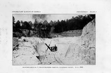
I. Klondike No. ~ mine, Edgar Brothers Company, Wilkinson County. July, 19~6......................................................................................(Frontispiece)
II. A. Golding Sons Company mine near Butler, Taylor County. B. Mining kaolin, Golding Sons Company mine near Butler, Taylor County............................................................................................ 66
III. A. Unloading the kiln, Averett Pottery, south of Lizella in Crawford County. B. Making flower pots, Middle Georgia Pottery Company, south of Lizella in Crawford County.............................. 90
IV. A. White Cretaceous sands and small kaolin lenses, Cuba Cut, east of Byron, Peach County. B. Red, cross-bedded sand with small reworked kaolin lenses, Macon Highway, east of Fort Valley, Peach County...................................................................................... 9~
V. A. Clay mine of the Clinchfield Portland Cement Company, north of Kathleen, Houston County. B. Twiggs County Kaolin Company, Old Rico Pit, near Phillips Station, Twiggs County.... 96
VI. A. Moore & Munger kaolin mine, Dry Branch, Twiggs County. B. Filter-presses in kaolin washer, Moore & Munger, Dry Branch, Twiggs County......................,............................................................. 108
VII. A. Kaolin mine of the Flamoga Clay Company, near Dry Branch, Twiggs County. B. Kaolin mine of the Georgia Kaolin Company, near Dry Branch, Twiggs County.......................................... ll8
VIII. A. W~~ aands ar...i. kaolin, railroad cut, Van Buren property, near Griswoldville, Jones County. B. Old Huckobee kaolin mine, opened in 1893, Jones County............................................................ liS~
IX. A. Mine of the Georgia White Brick Company, Gordon, Wilkinson County. B. Power plant and brick molding machine, Georgia White Brick Company............................................ ........................... 166
X. A. End of drier, Georgia White Brick Company, Gordon, Wilkinson County. B. Fire boxea and draft fan of tunnel-kiln, Georgia White Brick Company, Gordon, Wilkinson County........................ 170
XI. A. Edgar Brotheri Company, Edgar Plant near Mcintyre, Wilkinaon County. B. Edgar Brothers Company. Bauxite bouldera in overburden of Klondike No. 1 kaolin mine. Wilkinson County.... !'!~i
Xll. A. Mine of Akron Pigment Company, Mcintyre, Wilkinson County.
B. Plant of Akron Pigment Company, Mcintyre, Wilkinson County.................................................................................................. ~~6
VII
XIII. A. Outcrop of hard kaolin, Geo. H. Carswell's Old Clay Place, welit of Wriley, Wilkinson County. B. Outcrop of hard kaolin, W. P. Duncan property, north of Toomsboro, Wilkinson County...... ~48
XIV. A. Chimney rock overlying bauxite, Old General Reduction Company mine, Evens & Howard Fire Brick Company, Nadine, Wilkinson County. B. Hard kaolin in railroad cut, Ivey Estate, Beech Hill, Wilkinson County........_:......................................... 252
XV. A. Mine of the Dixie Fireproofing Company, Carrs Station, Hancock County. B. Fire brick plant of the Dixie Fireproofing Company, Carrs Station, Hancock County...................................... 294
XVI. A. Mine of Harbison-Walker Mining Company, near Gibson, Glascock County. B. Flint kaolin overlying hard kaolin, Harbison-Walker Mining Company, near Gibson, Glascock County.................................................................................................. 350
XVII. A. Mine of Albion Kaolin Company, Hephzibah, Richmond County B. Plant of Albion Kaolin Company, Hephzibah, Richmond County.................................................................................................. 400
XVIII. A. Old Garner bauxite mine, Springvale, Randolph County. B. McMichael Bauxite Mine, Kalbfleisch Corporation, north of Andersonville in Macon County............................................................ 420
FIGURES
PAGE
l. The topographic divisions of the Coastal Plain of Georgia.................................. 28
\i!. Section of railroad cut on the Phil Ogletree property, one mile north of Zenith, Crawford County.................................................................................... 84
3. Section of south end of first pit of Martin's "Gordon Clays" mine, three miles south of Gordon, Wilkinson County........................................................ 184
4. Section along branch, Dupree property, Wilkinson County, showing relation of bauxite, kaolin, and fullers earth. Numbers in the section refer to beds described in the geologic section above. After Shearer...................... 193
5. Section o' old Edgar mine, half a mile east of Edgar, Wilkinson County.-......... 217
6. Section of overburden at south end of Klondike No. I. pit, Edgar Brothers Company, showing pocket in bauxitic clay...................................................... 219
7. Map of the Dr. L. B. Robeson property, Washington County. From survey by D. W. Thorp, Jr., Oct., 1922.......................................................................... 309
VIII
PREFACE
Two reports on the clays of Georgia have previously been issued by the Geological Survey of Georgia. Bulletin 6, A Preliminary Report on a Part of the Clays of Georgia by Dr. Geo. E. Ladd, issued in 1898, was concerned only with the clays along the Fall Line. Bulletin 18, A Second Report on the Clay Deposits of Georgia by J. 0. Veatch, issued in 1909, was a comprehensive report on all the clay resources of the state and did much towards furthering their utilization.
Since Veatch's report was issued, the clay mining and working industries of Georgia have shown a remarkable progress. The shales of Northwest Georgia have found an extensive use in the manufacture of brick and tile. The brick and tile industry using the alluvia] clays of Middle Georgia has greatly increased. The production of sedimentary kaolin from Middle Georgia for filler, white ware, and refractory uses was in 19~7 over five times that of 1909. The center of the kaolin mining industry has moved from Twiggs County to Wilkinson County which was not producing in 1909. The increasing interest in the industry has led to the discovery of many deposits unknown at the time of Veatch's investigation. This interest in the kaolin deposits was further increased by investigations by the U. S. Bureau of Mines in co-operation with the Central of Georgia Railway, of which the published results are frequently referred to in the text, and in 19~6 by the meeting in Georgia of the American Ceramic Society. The need of a new detailed survey of the clay resources of the State was imperative.
The writer began his investigation of the clays of the State in July 19~6. The field seasons of 19~6 and 19~7 were spent in Middle and South Georgia simultaneously investigating the kaolins, bauxites, brick clays, and fullers earths. The physical and pyrometric tests on the kaolin and bauxitic clay samples collected were made by the writer in the winters of 19~6-~7 and 19~7-~8 at the Ceramic Laboratory of the Georgia School of Technology, under the direction of Dr. A. V. Henry, director of the Department of Ceramics. During a part of this time the writer was assisted by a number of the ceramic students. Such a large volume of data was collected on the sedimentary kaolins and associated bauxitic clays that it was decided to publish this report on them separately before undertaking further field work on the shales and brick clays.
It is hoped that the reader will understand the limitations of such a report. The field work, because of the large area covered, was of necessity limited to a visual examination of the outcrops exposed, and a collection of samples only where the outcrops were such as to give a fairly representative sample without prospecting. Efforts to
IX
induce property owners to prospect in advance of the writer's visit met with little success. At best many of the samples are indicative rather than representative. The laboratory work was limited by the large number of samples collected. Many almost necessary tests had to be omitted. The standard methods of testing clay samples as laid down by the American Ceramic Society were followed as closely as possible without unduly prolonging the work. But it must be clearly understood that unfavorable tests on a sample may not necessarily mean that all of the clay on the property will prove unsatisfactory. The writer in his descriptions has tried to clearly differentiate between observed and hearsay information as to the thickness, extent, and quality of deposits. Lack of time forced the writer to confine his attention almost wholly to purely economic features, and to neglect the many interesting problems of origin and of geologic and petrographic interest that await investigation.
The writer wishes to acknowledge his thanks to Mr. S. W. McCallie, the State Geologist of Georgia, for advice and assistance; to Dr. A. V. Henry, Prof. W. H. Vaughn, and the other members of the Ceramic Department of the Georgia School of Technology, who cooperated so willingly in the laboratory work and gave much valuable advice during the writing of the report; to Mr. J. lVI. Mallory, General Industrial Agent of the Central of Georgia Railway for much information and advice; to Mr. L. Hatfield of Gordon for freely giving of his time and knowledge in showing the writer the deposits of Wilkinson County; to the newspaper editors and secretaries of the Chambers of Commerce of Macon, Butler, Columbus, Americus and Augusta for valuable publicity and assistance; and to the managers and superintendents of all the kaolin mines visited for their help and cour-
tesy.
All of the chemical analyses that accompany the laboratory tests, unless otherwise stated, were made by Dr. Edgar Everhart, Acting Chemist of the Geological Survey of Georgia.
Atlanta, Georgia, June ~0, 19~9.
Richard W. Smith, Assistant State Geologist,
X
SEDIMENTARY KAOLINS OF THE
COASTAL PLAIN OF GEORGIA
HISTORY OF THE INDUSTRY
The sedimentary kaolins of the Coastal Plain of Georgia have been known since Colonial times. Legend has it that the Governor of the Province of Georgia learned of the secondary kaolins near Augusta and Macon and had some of the clay brought to Savannah, presumably by Indians in canoes down the Savannah River and the Ocmulgee and Altamaha Rivers, and shipped to the famous Wedgwood Pottery in England.1
Sholes2, in his chronological history of Savannah, states:
"1741-Porcelain clay was discovered in or near Savannah by Mr. Duchet, and china cups made. The trustees gave him fifty pounds sterling, to 'encourage him in his enterprise:"
Minton3 states that "As early as 17'66 American clays from Georgia, Florida and the Carolinas were being sent to England in considerable quantities. These clays were regularly imported and used by Wedgwood until the clays of England were available."
The discovery and use of the English kaolins ended the mining of the sedimentary kaolins of Georgia for over a century. An American pottery and white ware industry gradually developed around two centers, Trenton, N. J. and East Liverpool, Ohio, using at first local clays and then domestic primary kaolin and imported English kaolin. The use of English kaolins as fillers in the manufacture of paper became firmly established.
Not until 1876 was the mining of Georgia sedimentary kaolin revived. In that year the Riverside Mills of Augusta leased the Morgan Property (see page 397), nine miles southwest of Augusta in Richmond County, and for ten years mined kaolin, carted it to Augusta, used a portion of it in their product, and shipped the rest to northern and eastern markets.
The next kaolin mining was in 1880 by J. R. Van Buren of Griswoldville in Jones County. Mr. Van Buren states:4
1 Letter from J. M. Mallory, General Industrial Agent, Central of Georgia Railway, Savannah, Ga.
2 Sholes, A. E., Chronological history of Savannah, illustrated: p. 47, Savannah, Morning News (publishers), 1900.
3 Minton, L. H., New Jersey's part in the ceramic history of America: The
J Ceramist, voL 2, p. 271, 1922.
4 Letter from R. Van Buren to J. M. Mallory, General Industrial Agent, Central o Georgia Railway, Savannah, Ga., Mar. 4, 1926.
2
GEOLOGICAL SURVEY OF GEORGIL'l.
"I wish to state that I was the first party shipping clay for commercial purposes on the Central of Georgia Railway. In the year 1880, I shipped from my clay mine trainloads of clay consigned to Abbot and Goldmore (afterwards Montague and Company), Chattanooga, Tennessee. The clay was mined from my property in Jones County."
This mine was later abandoned.
J. W. Huckobee in 1893 opened a kaolin mine on the Central of Georgia Railway one mile west of Lewiston in Jones County. This mine was operated as the Lewiston Clay works until 190~, when the mine was abandoned. The kaolin was mined by hand, carefully handsorted to remove any that was off-color or contained grit, dried in open sheds, packed in hogsheads holding about a ton of dry clay, and shipped north for use in the wall-paper industry and in the manufacture of encaustic tiling and similar wares.
The first kaolin mine in the Dry Branch district of Twiggs County was opened in 1897 by Payne and Nelson. This mine, under the name of the Macon Mining Company, continued operations until 1901, when it was abandoned. It was followed in 1900 by the Georgia Kaolin Company, the first of the present day kaolin mines, and in 190!l by the American Clay Company and the Atlanta Mining & Clay Company. Other early mines were the Butler Clay Company in Taylor County, operated from 1896 to 1905 and later by Golding Sons Company, and the Albion Kaolin Company at Hepzibah in Richmond County, opened in 1900 and still in operation. Much credit is due to these early companies for their faith and perseverance in convincing the consumers of the value of the Georgia sedimentary kaolin in competition with the imported clays.
Twiggs County led the State in the production of kaolin until about 1915, when it was surpassed by wilkinson County. The importance of Wilkinson County as a kaqlin producer dates from the opening of a clay mine and plant in 1910 by Edgar Brothers Company, and their purchase of another small mine and plant opened in 1908. They were followed by other companies, so that since 1915 Wilkinson County has led the State's production of kaolin.
Mining methods were at first crude. The overburden was stripped by hand or by mule scrapers. The kaolin was mined by pick and shovel, more or less hand-sorted to remove stained pieces, air-dried on racks in open-air drying sheds, and shipped in bulk. Later mechanical scraping devices, steam-shovels, and, in one instance, hydraulic methods, were introduced to strip the overburden; and one or two companies are today using steam-shovels to mine the kaolin.
The Georgia Kaolin Company at Dry Branch was the first to install a washing plant. Since the erection of this plant in 1908, the larger companies have followed their example. Today probably two-
HISTORY OF THE INDUSTRY
3
thirds of the kaolin produced in Georgia is washed. The plants are all very much alike and, until recently, have been little improved in the last 20 years. The kaolin is blunged or put into a water suspension by some device that breaks up the lumps and agitates the particles until they have all slaked and the kaolin is in the form of minute, almost colloidal, particles suspended in the water. This is called "slip" and is about the consistency and color of skim-milk. The slip is run through long shallow troughs with the velocity so regulated that the fine sand and most of the mica flakes settle to the bottom of the troughs from which they are periodically removed. Several plants have recently installed a Stull whirlpool cone classifier before the troughs to remove the bulk of the sand and mica. Screens at the end of the troughs remove any mica flakes or trash that may have floated through with the slip. The slip is then run into one of a number of large concrete settling tanks, used in rotation, in which the kaolin is allowed to settle to a sludge and the clear water drawn off. The sludge is pumped through filter-presses for the final dewatering. These filterpresses consist of metal plates separated by heavy canvass cloth. The canvass retains the washed clay which builds up as a cake between the plates, while the water goes on through. It takes from three to six hours, depending on the clay, to fill and draw a filter-press. The cakes of kaolin from the filter-presses are dried by air, on racks heated by live steam, or in tunnel-driers, and are crushed or pulverized for shipment.
Two of the larger companies have in the last few years experimented with and are now producing special chemically treated kaolin of finer quality than the average washed kaolin. The Georgia Kaolin Company and Walker's Georgia Kaolin Mines are now remodelling their plants to use more modern methods of refining their product.
The greater bulk of the Georgia sedimentary kaolin mined has been used as a filler in the manufacture of paper and oilcloth. Since 1920, ever increasing amounts have been used as a filler in the manufacture of rubber. Its use in the manufacture of white ware has slowly increased as the ceramists have realized its possibilities and limitations.
In 1927, 42.5 per cent of all the kaolin and paper clay produced in this country came from Georgia.1
Refractories have been manufactured from Georgia kaolin since 1900 at Stevens Pottery, and since 1912 at Carrs Station. In addition, some kaolin has been shipped out of the State for use in the manufacture of refractories. Recently Babcock & Wilcox Company have erected a fire brick plant at Augusta; Evens & Howard Company of St. Louis, Mo., have purchased the fire Brick plant at Stevens Pottery; and Harbison-Walker Refractories Corporation have purchased the Evans and Deitrich property at Gordon. This should greatly
1 From Middleton, Jefferson, Clay in 1927: U. S. Bur. Mines Mineral Resources, 1927, pt. 2, pp. 262-263, 1929.
4
GEOLOGICLI.L SURVEY OF GEORGILI.
increase the amount of Georgia kaolin used in the manufacture of refractories.
The meetings of the American Ceramic Society in Georgia in 1926 probably did much to further the use of Georgia kaolin for white ware and refractories.
The following table gives the production of kaolin in Georgia since 1900, as given in the Mineral Resources of the United States by the U. S. Geological Survey.
Production of kaolin in Georgia
I Filler and White Ware
Refractories
I
Total
Year Quantity
--
Short Ton.r
Value
Quantity
Short Ton.r
Value
Quantity
Short Ton.r
Value
1900 1901 1902 1903 1904 1905 1906 1907 1908 1909 1910 1911 1912 1913 1914
1915 1916 1917
1918 1919 1920 1921 1922 1923 1924 1925 1926
-192-7 Total
6,885 $ 8,280 14,530 17,424 18,938 26,216 32,552 28,503 18,230 31,617 36,571
45,076 48,482
69,740 62,298
67,752 92,671 109,222 76,073 81,466 116,420 52,500 100,668 123,994 135,504 141,956 175,230 193,151
32,645 -------------------- --------------------
41,400
a
a
63,613 81,884
----------------------------------------
--------------------
--------------------
76,593
3,080 $ 4,557
99,060
2,712
3,307
141,765
6,070 14,568
126,253 15,080 14,060
87,540 13,803
9,005
147,753
a
a
184,529
7,821
6,031
199,135 11,363
8,866
210,908 12,863
8,196
299,110 13,650
8,475
267,011 11,461
7,116
292,943 12,033
7,577
417,394 10,370
6,703
573,707
1,727
5,652
552,083
2,073
7,665
682,467 14,121 21,172
1,025,819
1,703
9,282
388,480
2,660 11,735
709,745
2,235
8,550
867,808
4,066 18,427
975,422 21,977 49,300
1,040,06_4 26,413 52,568
1,357,923
a
a
1,492,857
a
a
6,885 $ 8,280b 14,530 17,424 22,018 28,928 38,622 43,583 32,033 31,617b 44,392 56,439 61,345 83,390
73,759 79,785 103,041
110,949 78,146 95,587
118,123 55,160 102,903 128,060 157,481 168,369 175,230h 193,151b
32,645 41,400b 63,613
81,884 71,150
102,367
156,333 140,321
96,545 147,753b
190,560
208,001 219,104
307,585
274,127
300,520 424,097
579,359
559,748 703,639
1,035,101 400,215
718,295 886,235
1,024,722
1,092,632 1,357,923b 1,492,857b
1,931,949 $ 12,435,911 197,28lc$ 282,812ci2,129,230d $ 12,708,731d
a Clay used for refractories not given separately. b Not including clay used for refractories. c Does not include production for 4 years not given separately. d Does not include clay used for refractories for 4 years.
PROPERTIES OF CLd.YS
5
PROPERTIES OF CLAYS1
Clay may be defined as "an earth or stony mineral aggregate consisting essentially of hydrous silicates of alumina, plastic when sufficiently pulverized and wetted, rigid when dry, and vitreous when fired at a sufficiently high temperature."
CLASSIFICATION OF CLAYS
Clays may be classified according to their origin, chemical and physical properties, or uses. The first classification is, perhaps, of most interest to the geologist, the second and third, which are related, to the technologist.
An example of a classification according to origin is the following by Ries,3 modified slightly by the writer:
Ries' Classification
A. Residual clays. Formed in place by rock alteration due to various agents, ofeither surface qr deep-seated origin.
I. Those formed by surface weathering, the processes involving solution, disintegration, or decomposition of silicates.
(a) Primary kaolins, white in color and usually white burning.
Parenl Rock
Shape
Granite, Pegmatite, Rhy- Blankets; tabular steeply
olite, Limestone, Shale, dipping masses; pockets
Feldspathic Quartzite,
or lenses.
Gneiss, Schist, etc.
(b) Ferruginous clays, derived from different kinds of
rocks.
II. White residual clays formed by the action of ascending waters possibly of igneous origin.
(a) Formed by rising carbonated waters.
(b) Formed by sulphate solutions.
III. Residual clays formed by action of downward moving sulphate solutions.
IV. White residual clays formed by replacement, due to action of waters supposedly of meteoric origin.
B. Colluvial clays, representing deposits formed by wash from the foregoing and of either refractory or non-refractory character.
1 Much of the information in this section was obtained from:
Ries, H., Clays; their occurrence, properties, and uses: 3d ed., 1927. Veatch, J. 0., Second report on tlie clay deposits of Georgia: Georgia Geol.
Survey Bull. 18, 1909. Stout, Wilbur, and others, Coal-formation clays of Ohio: Ohio Geol. Survey,
4th ser., BulL 26, 1923. 2 Standard definition. The standards report for the American Ceramic Society
for 1928: Am. Ceramic Soc. Jour., vol. 11, p. 347, 1928. 3 Ries, H., Clays, their occurrence, properties, and uses: 3d. ed., pp. 36-37,
1927.
6
GEOLOGICd.L SURVEY OF GEORGL1
C. Transported clays. I. Depositedin water.
(a) Marine clays or shales. Deposits often of great extent. White-burning days. (Sedimentary kaolins, ball clays). Fire-clays or shales. Buff burning. Impure clays or shales. { Calcareous. Non-calcareous.
(b) Lacustrine clays. (Deposited in lakes or swamps.) Fire-clays or shales. Impure clays or shales, red-burning. Calcareous clays, usually of surface character.
(c) Flood.:plain clays. Usually impure and sandy. (Alluvial brick-days of Georgia.)
(d) Estuarine clays. (Deposited in estuaries.) Mostly impure and finely laminated.
(e) Delta clays.
II. Glacial clays, found in the drift, and often stony. May be either red or cream-burning.
III. Wind-formed deposits (some loess.)
IV. Chemical deposits. (Some flint-clays.)
Other classifications are based on physical properties or uses. One of the best of these is that of Parmalee,l based on both the physical properties and uses of clays.
Strictly speaking, the word kaolin is applicable only to primary or residual kaolins, and the so-called kaolins of the Coastal Plain of Georgia should always be spoken of as secondary kaolins or sedimentary kaolins. This usage is not strictly followed by the ceramic industry, nor is it in this report.
MINERALS IN CLAYS
Clay, in its simplest form, would consist entirely of hydrated aluminum silicate, such as kaolinite or allied minerals. Since clays are formed from the decomposition of the rocks of the earth's crust, simple clays are rarely ever found. All clays contain more or less quantities of accessary minerals in addition to the hydrated silicates of aluminum. The quantity of accessary minerals varies greatly in different clays; ranging from a few per cent in the case of some of the sedimentary kaolins to 50 or more per cent in the case of some of the brick and other clays of common occurrence. These minerals, depending upon the proportion and size of the grain, often have a marked influence on the properties of the clay containing them. Because of the finely divided nature of clays, the minerals they contain are sometimes very difficult to determine under a high-power microscope.
1 Parmalee, C. W., and Schroyer, C. R., Further investigations of Illinois fire clays: Illinois Geol. Survey Bull. 38, pp. 278-280, 1922.
PROPERTIES OF CLAYS
7
HYDROUS ALUMINUM SILICATES
KAOLINITE
Kaolinite is a hydrated silicate of alumina, represented by the for-
mula Al,03.~SiO,.~H,O, which corresponds to a composition of Silica
(SiO,, 46.3 per cent; Alumina (AI,03), 39.8 per cent; and Water (H,O)' 13.9 per cent. It is white or pearly and occurs in hexagonal plates~
often in worm-like bunches. It has a hardness of ~ to ~.5 and a speci
fie gravity of ~.2 to 2.6. The mineral is commonly regarded as the
base of clays, though its presence as such is rarely detected with cer-
t~n~.
-
Kaolinite is a secondary mineral formed by the action of ascending or descending waters and carbon dioxide on other minerals. Feldspar is probably the common parent mineral, although the micas such as sericite may sometimes at least be an intermediate product.
MINERALS RELATED TO KAOLINITE
These include several species, all hydrated silicates of alumina. Some of these have been found as crystals and are very probably definite minerals in the strictest sense, but others are known only in an amorphous condition, and may be only mixtures of other minerals. Among the hydrated silicates of alumina related to kaolinite that have been described are: halloysite, montmorillonite, beidellite, allophane, newtonite, rectorite and leverrierite. Halloysite, differing from kaolinite in chemical character by containing more water, has been found in primary clays at several places in Georgia, but has not been recognized in the sedimentary kaolins.
Gibbsite (Al,03.3H,O) and diaspore (Al,O,.H,O), both aluminum hydrates containing no silica, are probably present in the sedimentary bauxitic clays of Georgia.
OTHER MINERALS
QUARTZ
Quartz, either in crystals or in the amorphous impure form of chert or flint, is the most common accessory mineral in clays. The sand or grit in clays is generally quartz. The amount of quartz may vary from less than one per cent, as is the case with a few of the Georgia kaolins, to 70 or 80 per cent in the more complex brick and other clays.
Quartz in days affects their refractoriness and behavior in firing, shrinkage, plasticity, and tensile strength. It also detracts very much from the value of certain clays which are used in the raw condition, such as those used for paper filler. Pure quartz has a pyrometric cone equivalent (see page 21) of about cone 3.5, but the presence of other minerals in the clay, especially if the quartz is in fine grains, may exert a fluxing action and cause the quartz to soften at a much lower temperature. Quartz sand in a clay acts as an anti-plastic
8
GEOLOGICLLL SURVEY OF GEORGld
tending to make it more open and porous and to reduce both the drying and firing shrinkage. Quartz changes its crystalline form at about 570C., accompanied by a sudden expansion of about 2~ per cent. this change often causes rupture of clay bodies containing an appreciable amount of quartz.
FELDSPAR
Feldspar is found in at least small quantities in nearly every clay, whether residual or sedimentary, but the grains are usually small since it does not resist abrasion and weathering as well as quartz. The sedimentary kaolins of Georgia usually contain less than one per cent of feldspar and some none at all. The grains are usually partly altered to kaolinite. Feldspar fuses at about cone 9, but if fine-grained it may begin to flux with the other ingredients of the clay at a much lower temperature.
MICA
Mica is found in nearly all rocks, both igneous and sedimentary, either as an original or secondary mineral. Since it is not easily decomposed by weathering agents and since it is readily carried in suspension by running water, it is a common constituent of clays. It is one of the few minerals in clay that can often be detected with the naked eye, for it occurs commonly in the form of thin, scaly particles whose bright, shining surface renders them very conspicuous, even when small.
There are several species of mica, all of rather complex composition, but all silicates of alumina, with other bases. Two of the commonest species are the white mica or muscovite, H,KAla(SiO.)a or 2H,O. KzO. 3Al,0,.6Si0z, corresponding to SiO,, 45.2 per cent; AlzOa, 38.5 per cent; K,O, ll.8 per cent; and water, 4.5 per cent; and the black mica or biotite, (H,K)z(Mg,Fe),Al,(SiO.)a (the amount of iron varies widely). The muscovite (or its fine-grained form, sericite) is the most abundant in clay, because it is not readily attacked by the weathering agents. The biotite, on the other hand, decomposes much more readily on account of the iron oxide which it contains. It is probable, however, that many of the micaceous minerals found in clay had best be called hydro-mica, a gradation between muscovite and kaolinite.
The sedimentary kaolins of Georgia, especially the soft varieties, all contain mica, often exceeding the quartz in amount.
The "shortness" or lack of plasticity in clays may in part be due to an abundance of mica. Finely divided micas, when mixed in a clay, appear to act as a flux. The coarser flakes often remain unchanged during the firing.
HYDROUS IRON OXIDE
Hydrous iron oxide is a common constituent of many clays. Its presence when in a finely divided condition is shown by the yellow
PROPERTIES OF CLAYS
9
or brown color of the material, in which case it may be present as a film on the surface of the grains, or possibly absorbed by them. Or it may occur in the form of accretions or concretions and limonitic crusts and layers. The beds of sandstone found in many sand or gravel deposits associated with some clays, are caused by hydrous-iron oxide cementing the grains together. The hydrated iron oxide is usually referred to as limonite, but it is probably a molecular mixture of several hydrous iron oxides.
Hydrous iron oxide has both a coloring and fluxing effect in the firing of clays. The presence of less than one per cent is often sufficient to produce a noticeable color effect in a fired clay and hence is an injurious constituent of kaolins for certain uses. The concretions of hydrous iron oxide cause fused blotches and black specks that are decidedly detrimental of the ware.
HEMATITE
Hematite, the oxide of iron, is a red color and may be found in clays, but it changes readily to limonite on exposure to the air and in the presence of moisture.
The red stain common in the sedimentary kaolins of Georgia may to some extent be due to iron oxide, but often a badly stained kaolin will burn white, showing that the stain is not hematite, but is probably organic.
MAGNETITE
Magnetite, FeaO., magnetitic iron ore, is not common in clays, but has been observed in the form of minute black grains in some of the sedimentary kaolins of Georgia1
PYRITE
Pyrite, the iron sulphide FeS,, is very frequently found in clays and shales and is an injurious ingredient, producing a blotched or speckled effect in fired wares. It is rare in the sedimentary kaolins of Georgia.
LIME CARBONATE
Lime carbonate, CaCOa, often occurs in clays as calcite, in the form of nodular concretions, or as fragments of limestone, and acts as a :flux. The sedimentary kaolins of Georgia are remarkably free from lime carbonate.
RUTILE
Rutile, TiO,, appears to be a wide-spread mineral in clays, but never occurs in large amounts or in large grains. It is usually ob-
1 Veatch, j. 0., Second report on the clay deposits of Georgia: Georgia Geol. Survey BuiL 18, p. 38, 1909.
10
GEOLOGICAL SURVEY OF GEORGIA
served in the form of microscopic grains or needles. The chemical analyses of the Georgia kaolins all show TiOz, usually ranging from one to two per cent, but it is probable that all of the Ti02 is not derived from rutile.
TOURMALINE
Tourmaline, a complex silicate of boron and aluminum, 1s sometimes found in very small quantities in kaolins.
ZIRCON
Small crystals of zircon, ZrSi04, have been observed in the sedimentary kaolins of Georgia.
GLAUCONITE
Glauconite, a hydrated silicate of potash and iron, occurs as green sandy grains in some clays. According to Veatchl, it is found in some of the clays of the Upper Cretaceous and lower Eocene of Georgia, but probably is not present in the pure kaolins.
HORNBLENDE AND PYROXENE
These minerals are silicates of calcium, magnesium, and iron. They are original constituents of igneous rocks and may occur in clays derived from these rocks. It is not improbable that some of the minute black specks observed in the white clays of the Coastal Plain are due to unaltered particles of hornblende or pyroxene.
MANGANESE OXIDES
Manganese oxide, probably pyrolusite, has been observed as stains along joint planes and in some of the sedimentary kaolins of Georgia.
Sommers2 gives the following results of a semi-quantitative microscopic examination of nine sedimentary kaolins from Georgia.
.Minerals found in nine Geor~ia sedimentary kaolins
1. White clay, Gordon, Ga., upper bed, Columbia Kaolin and .illuminum Company (Now Old Columbia .Mine, Gordon Kaolin Company, see pa~e 180).
2. Nodular clay, same location as above. 3. White clay, crude, .ilmerican Clay Company, Dry Branch, Ga., (see pa~e 108).
4. White clay, washed, san'Le location as above.
5. White clay, Houston Kaolin Company, Perry, Ga. (JV'ow Yancey property, see pa~e 92).
1 Veatch, J. 0., Op. cit., p. 41.
2 Sommers, R. E., Microscopic examinations of days: Washington Acad. Sci. Jour., vol. 9, no. 5, pp. 116-117, Mar. 4, 1919. Also in U. S. Geol. Survey Bull. 708, pp. 294-295, 1922.
PROPERTIES OF CLAYS
11
6. White part of mottled clay, same location as above.
7. Red part of mottled clay, same location as above. 8. White clay, Sweetwater (Bauxite) Mine, Andersonville, Ga. (see page .!;35). 9. Mottled clay, same location as above.
---------
1 234 5678 9 ------------------
Quartz_____............................ C S S S S
S ....................
Hydromica.......................... C
C C S S S .......... __________
Kaolinite____________________________ A S VA A S S S A A
Rutile.................................. S S S S C S S S S
Zircon.................................. ---------- S .......... S S S S
S
Tourmaline....--------------------- ---------- ---------- ---------- ---------- ---------- S S .......... ----------
~h~~A:~~::__-~~:::::::::::::::::::::: :::::::::: :::::::::: :::::::::: ::::::::::1-s-- -s-- :::::::::: :::::::::: ::::::::::
~~ll~1~~~~~:~::::::::::::::::::::1::::~:: ::~i:: :::::::::: ::::::::::(:x::: ::::i::: ::::i;: :::::::::: ::::::::::
The letters above indicate the relative abundance as follows: S =Scarce. C=Common. M =Moderate amounts. A =Abundant.
VA =Very abundant.
a Stained with hematite.
CHE::\HCAL PROPERTIES OF CLAYS
All the constituents of clay influence its behavior in one way or another, their effect often being noticeable when only small amounts are present. The various accessory constituents in clays have different properties. Most of them promote fusion, but some are far more active than others. A few are influential also in the development of colors. In a general way, the finer the accessary minerals and the more evenly they are distributed in the clay, the greater their effect in producing changes. The chemical analysis of a clay may give some indication of its properties, but its value is limited beca_use it does not show the exact minerals in which the elements are combined, the fineness of the grains, and other factors upon which the physical properties depend. The influence of the various components can perhaps be best discussed individually.
SILICA
Silica is present in clay in two forms, namely, uncombined as silica or quartz, and in silicates. The uncombined silica is usually quartz, but flint, chalcedony, or hydrous silica might be present. The sili-
12
GEOLOGICAL SURVEY OF GEORGIA
cates may be represented by kaolinite or other hydrous aluminum silicates, micas, feldspars, glauconite, hornblende, garnet, etc.
In the chemical analyses accompanying this report, the uncombined or free silica is reported as: sand, which includes quartz and any flint or chalcedony present, and hydrous silica. It will be noted that the amount of sand reported often differs from the amount of material not passing through the 200 mesh screen in the screen analysis. In cases where the amount of sand reported is larger than the amount of minus 200 mesh material, the difference is probably free silica in grains smaller than 200 mesh. Where the amount of sand reported is less than the amount of minus 200 mesh material, the difference is probably mica in flakes large enough to be caught on the screen. The silica in mica is combined silica, not free silica. The effect of the sand on the properties of clays has already been discussed under quartz (page 7).
All of the sedimentary kaolins of Georgia contain hydrous silica in the form of hydrated silicic acid or colloidal silica. The amount is generally less than a quarter of one per cent. Stull and Bole1 state that the hard kaolins are a little higher in silica than the soft kaolins. They go on to state:
"Evidently the hardness of these clays is due to free silicic acid. Its presence explains why spring waters flowing from the top of the clays are always opalescent and high in silica. The presence of silicic acid likewise accounts for the difficulty in slaking and filter-pressi,ng the hard and semihard clays and for their high plasticity and bonding strength. The lack of free silicic acid in the soft clays also accounts for their ease of slaking and filter-pressing, the clearness of the water coming from the filter-press, and their low bonding strength."
The chemical analyses accompanying this report fail to show that the hard kaolins are appreciably higher in either total or hydrous silica than the soft kaolins (see page 16).
ALUMINA
Most of the alumina found in clays is in combination with silica,
as a silicate. The chemical analyses accompanying this report show
that in most of the sedimentary kaolins of Georgia the percentage
of alumina is close to that of kaolinite (39.8 per cent alumina). The
average of 115 analyses was 38.97 per cent. The bauxitic clays con-
tain a larger percentage of alumina, due to the presence of the alumi-
num hydrates, gibbsite and diaspore.
The bauxitic clays are more refractory than the clays with a composition approaching kaolinite. The bauxitic clays also continue to shrink at higher temperatures than do the kaolins.
IRON OXIDE
The presence of iron in clays has already been discussed under the minerals: hydrous iron oxide, hematite, magnetite, and pyrite. The
1 Stull, R. T. and Bole, G. A., Beneficiation and utilization of Georgia clays: U.S. Bur. Mines Bull. 252, p. 12, 1926.
PROPERTIES OF CLAYS
13
iron oxides have both a coloring action and a fluxing action. In general, clay containing less than 1 per cent ferric oxide fires white; from 1 to ~ per cent fires to a light cream-color; and increasing amounts over ~ per cent fire to cream, buff, and red colors. However, the color to which a clay will fire cannot accurately be predicted from the amount of ferric oxide shown by the chemical analysis. The color and depth of shade probably depend upon: (I) the amount of iron in the clay; (~) the minerals or chemical combination in which the iron is present; (3) the size of the particles; (4) the presence of other minerals that may influence the color; (5) the temperature of firing; (6) the degree of fusion; and (7) the condition of the kiln atmosphere. The fluxing action of iron oxide probably depends upon similar factors.
The sedimentary kaolins of the Coastal Plain of Georgia have a content of ferric oxide usually ranging between 1 and ~ per cent. The average of 115 analyses was 1.43 per cent. The increase in alumina of the bauxitic clays is frequently accompanied by an increase in the iron oxide content.
TITANIUM
Titanium is an element which is very common in clays, usually in the form of rutile (see page D), but occasionally as titanite(CaTiSiOs) and ilmenite (FeTi03). These minerals are usually in the form of very minute crystals of needles, visible only with the aid of the microscope.
Titanium seems to have both a fluxing and a coloring action. Even small amounts will lower the pyrometric cone equivalent (see page 21) of a clay a cone or two. Titanium under reducing conditions gives the fired clay a bluish-gray color, and under oxidizing conditions a yellowish tint. The bluish color is neutralized to a certain extent by the presence of free silica.
The sedimentary kaolins of Georgia usually contain from 1 to ~ per cent of titanium dioxide. The average of 115 analyses was 1.13 per cent.
ALKALIES
The alkalies commonly present in clays include soda (Na20) and potash (K20). Several common minerals may serve as sources of these alkalies. Feldspar may supply either potash or soda. Muscovite, the white mica, contains potash and occasionally a little soda. Other minerals containing potash or soda are occasionally present, but probably these two minerals furnish most of the alkalies in clays.
The alkalies are considered to be the most powerful fluxing agent that clay contains. They serve, in firing, to bind the particles together in a dense, hard body, permitting the ware to be fired at a lower temperature. Alkalies alone seem to exert little or no coloring influence on the fired clay, although in some instances potash appears to deepen the color of a ferruginous clay in firing.
14
GEOLOGIC1L SURVEY OF GEORGIA.
The Georgia sedimentary kaolins generally contain less than hal of one per cent of soda and potash, and some contain only traces.
LIME
Lime is found in many clays, and in the low-grade ones may be present in large quantities. Quite a number of minerals may serve as sources of lime in clays, but all fall into one of the three following groups:
1. Carbonates: calcite, dolomite. Lime in this form if finely divided has a marked fluxing action, shortens the vitrification range, increases porosity, and decreases the coloring action of iron.
2. Silicates containing lime, such as feldspar, and some garnets and amphiboles. The effect of these is much less pronounced than that of lime carbonate. They serve as fluxes, but do not cause a rapid softening of the clay.
8. Sulphates: Gypsum. Gypsum in clay has probably often been formed by sulphuric acid, liberated by the decomposition of iron pyrite, acting on lime carbonate. On firing, the chemically combined water is first driven off, then the gypsum decomposes with the evolution of sulphur trioxide (SOa), often causing swelling or blistering of the ware.
The chemical analyses accompanying this report show that only a very few of the sedimentary kaolins of Georgia contain any lime. When present, it is probably in the form of a silicate.
MAGNESIA
Magnesia (MgO) rarely occurs in clay in larger quantities than 1 per cent. When present, its source may be any one of several classes of compounds, that is silicates, carbonates, and sulphates. Silicates, such as the black mica or biotite, are probably the most important source. Biotite decomposes readily, and, its chemical combination being thus destroyed, the magnesia is set free, probably in the form of a soluble compound, which may be retained in the pores of the clay. Magnesia acts as a flux, making the clay soften slowly.
The sedimentary kaolins of Georgia are very low in magnesia. The average of 115 analyses was only .04 per cent, and over half of them contained only traces or none at all.
SULPHUR
Many clays contain at least a trace of sulphur, and some of them show appreciable quantities. It may be present as:
1. Sulphate, such as gypsum (CaS04.2H20), epsomite (MgS04. 7H20), or melanterite (FeS04.7H20).
2. Sulphide, as pyrite (FeS2). Sulphur in any form is one of the most detrimental impurities in clays, as its compounds are instrumental in scumming, lowering of
PROPERTIES OF CLAYS
15
fusion point, bloating of body, and blistering.
Over half of the sedimentary kaolins of Georgia show at least traces of sulphur, but the average of 115 analyses was only .13 per cent.
PHOSPHORIC ACID
Phosphorous, or the phosphoric acid radical, P206, is common in small quantities in clays. It may be present in the form of the phosphate of lime, the phosphate of iron, or even other phosphates. Its effect in small quantities is not known, but in sufficient quantities it may act as a flux at moderate temperatures, giving greater translucency to bodies but less hardness and durability.
About half of the Georgia kaolins contain at least traces of P 20 6. In 115 analyses, the maximum was 1.33 per cent, and the average was .07 per cent.
WATER IN CLAY
Water is present in clays as free water and chemically combined water.
Free water: This includes that which is held in the pores of the clay by capillarity. It may include water of plasticity, shrinkage water, and pore water.
Water of plasticity is that which is driven off when the clay is dried from a condition of maximum plasticity to 110C.
Shrinkage water is that portion of the water of plasticity which is driven off up to the point where shrinkage ceases.
Pore Water is that portion of the water of plasticity which is driven off from the point where shrinkage ceases until the clay has reached approximately constant weight at 110C.
The water of plasticity is therefore equal to the sum of the shrinkage and pore water.
The kaolin samples collected and tested by the writer were all rather thoroughly air-dried before the chemical analyses were made. The moisture shown in the analyses is therefore usually less than 1 per cent and represents only a portion of the pore water.
Chemically combined water: Chemically combined water is that which exists in the clay in chemical combination, the water of crystallization of the hydrous minerals. That which is combined in hydrous aluminum silicates passes off chiefly between 400C. and 600C., muscovite loses its water between 500C. and 700C., and hydrous iron oxides dehydrate between 150C. and 350C. Unless a clay contains considerable limonite or hydrous silica, the percentage of combined water is commonly about two thirds the percentage of alumina found in the clay. The loss of its combined water is accompanied by a slight but variable shrinkage in the clay, which reaches its maximum some time after all the volatile matters have been driven off.
Summary of Chemical Analyses of 115 Typical Georf!ia Sedimentar,y Kaolins
.....
0'1
-
----
- - - - - - - - - -----
Soft (54)
II
Semi-hard (14)
II
Hard (47)
II
All types (115)
I I I I I I I I Lowest Highest Average\! Lowest Highest Average\\ Lowest Highest Average\\ Lowest Highest Average
I per cent per cenl per cent per cenl per cenl per cenl per cent per cent I per cent per cent per cent per cent ~
~
AJ20a t ----------------
Si02t-----------------Hyd. Si02---------Fe20a-----------------Ti02-------------------Na20-----------------MK2g0O---_-_-_-_-_-_-_-_-_-_-_-_-_-_-_-_-__-
P.os-------------------SOa ------------------Loss on lgn. ____
34.97 38.16
.01 .47 .54 trace trace .00 .00 .00 11.68
42.79 46.79
.85 2.34 1.80
.85 .42 .35 1.33 2.00 15.74
39.16
43.11 .18
1.21 1.14
.12 .09 .04
.11
.16 13.36
35.31 40.54
.08 .61 .54 trace trace .00 .00 .00 12.24
40.59 45.16
.35 4.69 1.80
.22
.10
.14 .77 .34 14.10
38.71
43.33
.17
1.46 1.20
.10 .06 .OJ .10 .05
13.32
33.09 37.45
.06 .50 .62 trace trace .00 .00 .00
11.48
43.50 46.06
.72 3.19 2.16
.62 .46 .28 .19 .50 14.16
38.83 42.85
.24
1.68 1.09
.19 .09 .04 .02 ..11 13.15
33.09 37.45
.01 .47 .54 trace trace .00 .00 .00 11.48
43.50 46.79
.85 4.69 2.16
.85 .46 .35
1.33 2.00 15.74
<:::>
38.97 ~
R 43.03 .20 1:-i
1.43 1.13
.15
V:l
.09 .04 .07
~
~
.13 13.28
~
~
~
t Corrected by subtracting sand from total and recalculating to 100 per cent.
t Corrected by subtracting sand from Si02 and total and recalculating to 100 per cent.
~
~
Note: All analyses of clays not typical soft, semi-hard, or hard kaolins in appearance were omitted.
PROPERTIES OF CLAYS
17
In the analyses accompanying this report, the chemically combined water is reported as Loss on Ignition. Loss on ignition also includes any carbon dioxide, sulphur, and organic matter which may be present in the clay, but the sedimentary kaolins of Georgia contain very little of these.
PHYSICAL PROPERTIES OF CLAYS
The physical properties of a clay in the raw or green state, and its reactions to the forming and firing processes necessary to produce clay ware of any sort, are, to a large extent, the deciding factors in determining the value of the clay and the uses to which it is best suited. A knowledge of these properties and the tests by which they are determined is essential to a correct understanding of the descriptions and tests given in a subsequent part of this report. In this description emphasis has been placed upon the most important physical properties of the sedimentary kaolins of Georgia.
PROPERTIES IN THE RAW STATE
FINENESS OF GRAIN
The size of the grains composing clay varies from that of small pebbles to particles so extremely minute as to remain in suspension in water for several days and be beyond the measurement of the highest-power microscopes, in other words, colloidal. The coarseness or fineness of grain in clays plays an important part in their plasticity, strength, porosity, fusibility, shrinkage, and color.
A number of different methods have been devised for determining the grain size of clays. They involve various principles such as screening, separation by settling, elutriation and by water currents.
The sedimentary kaolins of Georgia are noted for their fineness of grain. The hard kaolins, when thoroughly blunged in water, often have a considerable portion of the clay remain in suspension for several days. Screen analyses were made on the soft kaolin samples collected for this report. With a number of them, over 95 per ceht of the clay passed through a ~00 mesh screen.
SLAKING
The slaking of clays is the property they have, when dry, of crumbling and disintegrating into a pulverulent mass when immersed in an excess of water. The time required for this varies from a few minutes in the case of soft porous clays to several weeks for tough shales, and some may be incompletely disintegrated even after that. In slaking, the water first fills the pore spaces of the clay; then the particles of clay are entirely surrounded by a film of water, being separated from each other by the thickness of the film, thus causing an increase in the volume of the clay. In an excess of water, the clay grains become so far separated from each other that the clay mass crumbles. The
18
GEOLOGIC.d.L SURVEY OF GEORGI.d
process seems to be entirely physical and it is doubtful if any disintegration is due to chemical action, as in the slaking of quick lime.
The slaking property is one of some practical importance, as easily slaking clays temper more readily when worked, or if the clay is to be washed, it disintegrates more rapidly in the washer. In white ware manufacture the rate of slaking of a clay is of importance in determining the. time necessary to blunge the body mixture.
PLASTICITY
Plasticity may be defined as the property which many clays possess of changing form under pressure, without rupturing, which form they retain when the pressure ceases, it being understood that the amount of pressure required, and the degree of deformation possible, will vary with the material.
A number of theories have been advanced in explanation of this property, but clay technologists are not yet fully agreed upon the cause. Probably the most widely accepted theory at the present time is the colloid theory, which assumes that clay grains of non-plastic character are surrounded by a film of colloidal material. This colloidal material, which may vary in its composition, is in a film of water. This mixture has the properties of a viscous fluid. The colloidal fluid acts as a cementing fihn which holds the mass together and gives the material properties which are intermediate between those of a solid and a liquid. It is probable, however, that plasticity is due not to one but to several causes.
No practical method has been devised for measuring plasticity, and the loose terms used to describe it are of little value for comparative purposes. The description of the plasticity of clays is a matter of judgement and will vary with the individual. Very fine grained, plastic clays are commonly described as "fat," while coarse grained, sandy clays, or those lacking in plasticity, are termed "short" or "lean."
Plasticity generally bears a relation to the air shrihkage and drying qualities of clays. Those clays which are most plastic generally have the highest drying shrinkage and are more likely to crack in drying. However, some of the sedimentary kaolins of Georgia are very plastic, but show a much lower drying shrinkage than would be expected.
STRENGTH
The air-dried or "green" strength of a clay is a very important property in the manufacture of clay products. It enables them to be handled and to resist shocks before firing without serious loss from breakage. Through it, also, the clay is able to carry a large quantity of non-plastic material, such as flint, feldspar and grog.
The stre;ngth of a dry clay may be determined by the transverse, tension, or compression tests. Formerly the tensile strength was the property commonly determined, but now the transverse strength
PROPERTIES OF CLLJ.YS
19
test is usually employed because it gives more uniform results.
The transverse strength is the resistance which a bar of clay offers to a load applied at right angles to its length. The test is made by molding the clay into a bar which is thoroughly dried, supported on two knife-edges, and broken by slowly increased weight applied to a knife-edge on the upper surface. From the weight required to break the bar, the cross-section of the bar, and the distance between the supports, the green modulus of rupture is calculated. This is a factor of the transverse strength expressed in pounds per square inch or in corresponding metric units.
The green modulus of rupture of the sedimentary kaolins or Georgia tested varied from 10 pounds (or less) to 702 pounds per square inch. The soft kaolins on the whole are much weaker than the hard kaolins.
DRYING SHRINKAGE
The diminution in volume of clay, due to the loss by evaporation of the water used in developing plasticity, is termed air shrinkage or drying shrinkage. The drying shrinkage of a clay may be expressed either in terms of its length (linear drying shrinkage) or in terms of its volume (volume drying shrinkage). It depends upon such factors as the texture of the clay and the amount of colloidal material it contains, the amount of water used to develop maximum plasticity, and the rate and method of drying.
A knowledge of the drying shrinkage of a clay is important for the production of exact and uniform sizes of clay ware. A high drying shrinkage can often be counteracted by the addition of sand or materials of a sandy nature. These in addition make the mixture more porous, facilitating the drying, permitting the water to escape more readily, and reducing the danger from cracking.
The linear drying shrinkage of the kaolins tested for this report ranged from 0.5 per cent to 9.1 per cent. The average of the soft and semihard kaolins was 3.45 per cent, of the hard kaolins was 4.53 per cent, and of both together was 4.03 per cent.
FIRED PROPERTIES
FIRING SHRINKAGE
All clays shrink during some stage of the firing, even though they may expand slightly at certain temperatures. The firing shrinkage, like the drying shrinkage, varies within wide limits, the amount depending partly on the quantity of volatile elements, such as combined water, organic matter, and carbon dioxide, and partly on the texture and fusibility. After the volatile elements have been driven off, the clay is left more or less porous, in addition to its porosity caused by the grains not fitting closely together. As fusion begins, the pore spaces are closed up by the gradual melting of the constituent grains
20
GEOLOGICAL SURVEY OF GEORGIA
of the clay, thereby causing a gradual, but not always uniform, shrinkage in volume, until the point of vitrification is reached, when the mass becomes homogeneous and non-porous. Beyond vitrification there may be expansion due to the volatilization of the clay.
Either the linear or volume firing shrinkage at any temperature or cone (see next page) may be determined. It may be expressed in terms of the phstic volume or length or in terms of the dry volume or length. The total shrinkage is the sum of the drying shrinkage and the firing shrinkage, provided both are expressed in the same terms.
In the manufacture of clay ware it is important to get as low a firing shrinkage as possible in order to prevent cracking and warping. This may be done by mixing clays, or by the addition of materials such as flint, sand, and grog that in themselves have no firing shrinkage within the firing range of the ware.
The linear firing shrinkage (based on dry length) at cone 9 of 197 Georgia kaolins tested for this report ranged from ~.4 per cent to 17.1 per cent, with an average of 9.37 per cent. Experiments by various workers on the Georgia sedimentary kaolins indicate that with most of them the greater part of the firing shrinkage takes place before cone 14 or cone 16, and that the shrinkage from that point to the point of vitrification is very gradual. Refractories made from these clays should be fired to this point where the firing shrinkage curve flattens out. This is not true of the bauxitic chys, which continue to shrink at the same rate to much higher temperatures.
POROSITY AND ABSORPTION
The porosity of a clay may be defined as the volume of the porespace between the clay particles, expressed in percentages of the total volume of the clay, and depends upon the shape and size of the particles making up the mass. There are two types of pores in fired clays, open and closed. The volume of the latter cannot be directly measured. Thus there are two types of porosity; true porosity, which represents the volume of the open plus the closed pores; and apparent porosity, which represents the volume of the open pores only.
Absorption is a measure of the apparent porosity represented by the quantity of water a unit weight of the body will take up.
Porosity and absorption in a fired clay decrease as the firing continues and the firing shrinkage decreases the volume of the pore space, approaching zero as the clay approaches vitrification. Porosity has an important bearing upon the strength of a fired clay body, its behavior as an absorbent, and its resistance to weathering, shock, abrasion, erosion, slagging, temperature strain, discoloring agents, as well as its effect on certain properties such as bulk density, dielectric strength, permeability, and thermal and electrical conductivity.
PROPERTIES OF CL1YS
21
WARPING AND CHECKING
Warping and checking (more or less of a network of small surface cracks) in a fired clay body are due primarily to unequal shrinkage during either or both the drying and the firing stages. They are very difficult to avoid with clays having a high shrinkage. Most of the sedimentary kaolins of Georgia that were tested showed more or less warping and checking. However, in the manufacture of white ware these clays are never used alone, but always with other clays and materials. Such body mixtures usually have a low shrinkage and consequently little or no warping and checking.
PYROMETRIC CONE EQUIVALENT
(F"CSIBILI'l'Y)
A clay, carried beyond the vitrification stage in firing, softens, becomes viscous and flows, and finally is completely melted. For a particular clay this end point is reached at a definite temperature only when a definite method of heat treatment is followed. If the temperature is increased rapidly, the end point will be at a higher temperature than if the temperature is increased slowly. This end point is therefore best measured by means of standard pyrometric cones. When so measured, following a definite prescribed heat treatment until a cone of the clay bends until the tip touches the plaque, it is called the pyrometric cone equ.-ivalent of the clay.
Standard pyrometric cones are pyrometric measures of heat treatment in the form of a series of cones, made from ceramic materials, and carefully compounded so as to soften or melt in progressive order. They do not definitely measure temperature, but the combined effect of temperature and time or conditions of heat treatment. They were first established by Seger and are often called Seger cones. The series of American standard pyrornetric cones with their end points as determined by Fairchild and Peters1 is given in the following table:
1 Fairchild, C. 0., and Peters, M. F., Amer. Ceramic Soc. Jour. vol. 9, p. 738, 1926.
22
GEOLOGICAL SURVEY OF GEORGIA
End Points of .tlmerioan Standard Pyrometrio Cones
End Point (heated in air)
Cone No.
022 021 020 019 018 017 016 015 014 013 012 011 010 09 08 07 06 05
04 03 02 01
I 2
3 4 5 6 7 8 9
lO 11
12 13 14 15 16 17 18 19 20
25
Heated at 20C. per hour
Heated at 150C. per hour
II
oc.
op.
oc.
oF.
I
585
1085
605
1121
595 625
1103 1157
I
615 650
1139 1202
630
1166
660
1220
670
1238
720
1328
720
1328
770
1418
735
1355
795
1463
770
1418
805
1481
795
1463
830
1526
825
1517
860
1580
840
1544
875
1607
875 890
1607 '
905
1634
895
1661 1643
930
1706
930
1706
945
1733
950
1742
975
1787
990
1814
1005
1841
1015
1859
1030
1886
1040
1904
1050
1922
1060
1940
1080
1976
1115
2039
1095
2003
1125
2057
ll10
2030
ll45
2093
ll25
2057
ll60
2120
ll35
2075
ll65
2129
1145
2093
1170
2138
ll65
2129
1190
2174
1180
2156
1205
2201
1190
2174
1230
2246
1210
2210
1250
2282
1225
223.7
1260
2300
1250
2282
1285
2345
1260
2300
1305
2381
1285
2345
1325
2417
1.310
2390
1335
2435
1350
2462
1350
2462
1390
2534
1400
2552
1410
2570
1435
2615
1450
2642
1465
2669
1465
2669
1475
2687
1485
2705
1490
2714
1515
2759
1520
2768
1520
2768
1530
2786
Heated at l00C. per hour
........................................................ !
1580
I
2876
PROPERTIES OF CLAYS
23
End Points of American Standard Pyrometric Cones
End Point (heated in air)
Cone No.
Heated at 20C. per hour
Heated at l00C. per hour
26
--------------------------------------------------------i'
1595
2903
27
--------------------------------------------------------! 1605
2921
Z8
--------------------------------------------------------i 1615
2939
29
--------------------------------------------------------1
1640
2984
30
--------------------------------------------------------! 1650
3002
31
1680
3056
32
1700
3092
33
In Arsen furnace at 600
1745
3173
34
per hour
1760
3200
35
1785
3245
36
1755
3191
i
1810
3290
37
1775
3227 i
1820
3308
38
1810
3290 I 1835
3335
39 40 41
1830 1850 1865
3326 3362 3389
i---------------------------------------------------
1::::::::::::::::::::::::::::::::::::::::::::::::::::::::
42
1885 1970
3425 3578
l---------------------------------------------------
1
2015
3659
I
I
Standard pyrometric cones are used in firing clay ware or test pieces by embedding a series of three or more different cones in a vertical or slightly inclined position in a plastic clay base, and placing them adjacent to the ware. As the temperature rises, the cones in order soften and bend over. The end point is when the tip just touches the base, when the cone is said to be "down." They are widely used in the firing of all types of clay ware, sometimes as the only means of measuring the heat treatment, and sometimes to supplement the use of pyrometers. The use of standard pyrometric cones in determining the pyrometric cone equivalent of a clay is described on page 57.
The sedimentary kaolins of Georgia are all very refractory, having an average pyrometric cone equivalent of about cone 34. The lowest was a flint kaolin at cone 31. Several of the bauxitic clays were above cone 35.
FACTORS AFFECTING THE UTILIZATION OF CLAY DEPOSITS
A number of factors, in addition to the quality of the clay, must be considered in determining the possibility of mining and utilizing any
24
GEOLOGICdL SURVEY OF GEORG!d
deposit of clay. These factors are discussed in brief below with special reference to the sedimentary kaolins of Georgia. They are given as much consideration as possible in the detailed descriptions of deposits that make up the bulk of this report.
ACCESSIBILITY
The value of a clay deposit decreases sharply with its distance from railroad transportation. The clay, either in the raw state or in the form of a finished product, must be transported to its market. Spur tracks from the railroad to the deposit can be built only at a considerable cost. The problem is usually solved by narrow-gauge tramhaulage of the crude clay from the mine to a plant built near the railroad, but if the distance is long or the grade steep, the haulage and maintenance costs are high. The limit of distance from a railroad beyond which a clay deposit cannot be economically worked depends upon the quality and value of the clay. At the present time in the Georgia kaolin industry this limit, for tram-haulage, is from 3 to 6 miles, depending on the quality of the kaolin. As the deposits nearer the railroads are exhausted in the future these limits may be extended.
Soft kaolin that must be washed before shipment can be blunged at the mines and pumped in a pipe-line to a washing plant at the railroad. This method, in addition to being cheaper than tram-haulage, has the additional advantage of more thoroughly blunging the clay before removing the sand and other impurities. It will also increase the distance from railroad transportation that a soft kaolin deposit can be operated.
Aerial-tramways offer a solution for the transportation of clay up and down slopes too steep for the economical operation of the ordinary tram-haulage.
SIZE OF DEPOSITS
The tonnage of clay in a deposit must be at least approximately determined by prospecting before going to the expense of opening up the deposit for mining. A modern washing plant or a plant for the manufacture of refractories requires a large investment and should only be undertaken with a sufficient tonnage of the clay in sight to insure production long enough to amortize the investment.
The thickness of a clay deposit has an important influence on the mining costs. Deposits of Georgia kaolin only 4 or 5 feet in thickness have been mined under favorable conditions, but as the thickness increases, the mining costs per ton decrease.
CHARACTER AND UNIFORMITY OF DEPOSITS
The ideal clay deposit would be uniform in character throughout the entire deposit, so that a ton of clay mined from any place would be exactly like a ton mined from any other part of the deposit.
UTILIZdTION OF CLdY DEPOSITS
25
Such an ideal condition is rarely ever found in a clay deposit. Layers of different varieties of clay are often found. The character of the clay is apt to change from place to place in the same layer. Some Georgia kaolin deposits are softer on the outcrop than back in the deposit under heavier overburden. Others change in color or in the amount of impurities they contain. Thin lenses or beds containing sand or other impurities not visible on the outcrop are encountered as the deposit is mined. These all add to the mining costs. Some layers must be discarded or left behind in the mining. The others have to be blended as much as possible in the mining and washing so that the product shipped will be uniform from day to day and year to year.
Great care should be taken in prospecting a clay deposit to note variations in the clay and impurities. Auger borings should be supplemented by prospect pits or wells which better expose such variations.
OVERBURDEN
Overburden consists of any material overlying a deposit that must be removed and thrown away in order to mine the deposit. The thickness of overburden that can be removed economically from a clay deposit depends upon: the value and thickness of the clay, the charac~ ter of the overburden, and the other mining and preparation costs.
More overburden can profitably be removed from a high-grade clay such as a kaolin than from a low-grade clay such as a brick clay. It has been stated that the thickness of overburden that can profitably be removed from a Georgia kaolin deposit is approximately twice the thickness of the kaolin, but this statement should be modified by so many other factors as to render it almost valueless. A clayey overburden is more expensive to remove than loose sand, and an indurated or rocklike one still more expensive to remove. Prospecting should note the character as well as the thickness of the overburden.
Disposal of the overburden is often a troublesome problem to the operator. A clay pit so located that the overburden can be thrown back into the worked out portions of the pit or dumped down the slope from the pit has an advantage over a pit so confined in its location that the overburden must be transported some distance before it can be dumped.
DRAINAGE
Surface water is often very troublesome to a clay producer. Rain water seeps through a sandy overburden until it strikes the relatively impermeable clay deposit, along which it flows and collects in the clay pit, bringing with it impurities which discolor the clay. The
operator of a deposit located on a slope sufficiently high above the
streams can dig drainage ditches to prevent a greater part of the surface water from entering the pit and to quickly remove that which does find its way in. The operator of a deposit located in a flat valley
26
GEOLOGICAL SURVEY OF GEORGI1
bottom must install and operate at a considerable expense pumping equipment to remove the rain water and often a considerable seepage from nearby streams, avoiding as best he can discoloration of his clay by the water.
WATER SUPPLY
A nearby supply of soft water is necessary for the operation of the boilers of any steam-powered equipment used in mining a clay deposit. A large supply of pure water suitably located is necessary if the clay is to be washed before shipment. Many of the Georgia kaolin deposits are located with abundant streams conveniently near to the deposits or the plant sites. In most of the kaolin producing districts of Georgia ample water supply can be obtained from deep wells.
CLIMATE
Advantages of the climate of one region over another often means lower mining costs for that region. The climate of Middle and South Georgia in which the sedimentary kaolin deposits are located is suitable for mining and all types of plant operations the year around. The warm weather of the summer has no effect on the colored labor commonly employed in the mining operations. Rain may cause slight interruptions of mining operations in the winter months, but never cold weather or snow. Plant buildings need not be heavily constructed nor completely enclosed, and heating costs are low. Less fuel is required for power or the manufacture of ceramic products because of lessened radiation losses. Living conditions are ideal.
LABOR
Georgia has the advantage of low-priced and plentiful labor. Unskilled labor adapted to the climatic conditions is supplied by the colored population. The white population is intelligent native American stock capable of being trained to fulfill any class of skilled labor necessary. The cost of living is and will remain cheaper than in the more rigorous climate of the North.
POWER
Power is necessary for any mmmg or ceramic operation. Lowpriced coal from Alabama and Tennessee and an abundance of hydroelectric power insure lowered mining and manufacturing costs in the kaolin districts of Georgia. Several interlinked hydro-electric power lines cross the principal kaolin producing counties. A project is underway to pipe natural gas from Louisiana to Middle Georgia, including several of the kaolin producing centers.
GEOLOGY
27
GEOLOGY OF THE COASTAL PLAIN
OF GEORGIA
PHYSIOGRAPHIC HISTORY1
The State of Georgia may be divided into five physiographic provinces: the Lookout Plateau, the Appalachian Valley, the Highlands, the Piedmont Plateau or Central Upland,' and the Coastal Plain.
The Piedmont Plateau or Central Upland is in general an area of fairly strong relief sloping southward from the Appalachian Valley and the Highlands to the Coastal Plain. It comprises approximately 31 per cent of the whole State. The greater part of this area is underlain by metamorphic rocks, such as gneisses and schists, of Pre-Cambrian age, much tilted, distorted, and folded, and intruded by many large and small masses of granites and other igneous rocks of a later age. They are the roots of ancient mountains formed at some remote period, probably during the early part of what is known as the Paleozoic era.
These mountains, during the long geologic ages that ensued between their folding and elevation and the beginning of Cretaceous time, were worn down to a plain by the agencies of erosion. This plain probably extended far south of the present Piedmont Plateau. Its surface did not rise more than a few hundred feet above the level of the sea at that time. Streams meandered sluggishly over the plain, and the rocks were deeply weathered.
At the beginning of the Cretaceous period this plain was tilted, the northern end being elevated and the southern end depressed under the level of the sea. The streams on the elevated northern end began to cut rapidly into the thick mantle of weathered material and transport it south into the sea, the shore line of which was probably some distance north of the present southern boundaries of the Piedmont Plateau. The material thus transported from the Piedmont Plateau into the sea was deposited there and formed the Cretaceous deposits of the present Coastal Plain.
From the Cretaceous until the present time this process has been repeated many times. The northern part of the area has been elevated, worn down nearly to base level, and re-elevated and worn down. This has not taken place equally over the whole area and traces of several of the stages can be seen in the various plateau levels that make up the Central Upland. The southern edge of the area and adjoining parts of the Coastal Plain have at times been depressed below sea level and received marine deposits, and at other times have been elevated out of the sea and partially eroded. The shore line has fluctuated back and forth, finally extending further and further south.
I Compiled from LaForge, Laurence, and others, Physical geography of Geor-
gia: Georgia Geol. Survey Bull. 42, 1925. 2 Name preferred by LaForge, Laurence, and others, Idem, p. 57.
28
GEOLOGICAL SURVEY OF GEORGIA
The last elevation which brought the land to its present position took place since the beginning of the Quaternary period of geologic time, the period in which we are now living. In this manner over a thousand feet of material have been removed from the Piedmont Plateau and deposited in the sea to form the present Coastal Plain.
The Coastal Plain of Georgia, the origin of which has just been described, includes about three-fifths of the total area of the State. It is a part of the Gulf and Atlantic Coastal Plain which extends from
Texas up the Mississippi River as far as Illinois and up the Atlantic Coast to New Jersey. North from Alabama, the Coastal Plain borders the area of hard crystalline rocks known as the Piedmont Plateau. The streams, where they flow from the hard crystalline rocks to the softer sedimentary rocks of the Coastal Plain, have in many cases developed falls or rapids. These falls and rapids, because of their water power and position at the head of navigation, determined the location of many cities, including Augusta, Macon, and Columbus in Georgia. The boundary line between the hard crystalline rocks of the Piedmont Plateau and the sedimentary rocks of the Coastal Plain is called the Fall Line. In Georgia it is a crooked line connecting Columbus, Macon, Milledgeville, and Augusta.
Fig. ].-The topographic divisions of the Coastal Plain of Georgia.
GEOLOGY
29
The word "plain" used in the combination "Coastal Plain", is less suitable in Georgia than in some of the states farther north, for much of the Coastal Plain of Georgia is not level. It is true that great stretches in the southeastern part of the State are flatter than the sea bottom itself, but other parts are rolling or hilly. The most conspicuous topographic divisions are: the Fall Line Hills, the Fort Valley Plateau, the Dougherty Plain, the Louisville Plateau, the Tifton Upland, and the Coastal Terraces. A map of these divisions is shown in Figure 1.
The sedimentary kaolin deposits of Georgia are almost wholly found in the Fall Line Hills division. This belt of hills varies in width from a maximum of 80 miles along the Chattahoochee River to a minimum of three or four miles east of Flint River. In places the Fall Line Hills are rolling hills with long, gentle slopes and broad, flat-bottomed valleys. At other places, as in the kaolin districts of Twiggs, Wilkinson, and Washington counties, the topography is more rugged. Here the Fall Line Hills are remnants of a level to rolling plateau that has been so deeply dissected by numerous streams with deep, narrow valleys that only narrow flat-topped ridges are left of the original plateau.
GEOLOGICAL FORJVIATIONS1
The geology of the Coastal Plain is less complex than that of other parts of the State. The region is underlain by sediments ranging in age from Upper Cretaceous to Recent which outcrop in roughly parallel bands with the oldest resting upon the crystalline rocks of the Central Upland or Piedmont Plateau and the youngest at the sea coast. The beds dip gently southeastward at rates ranging from about 35 feet to the mile at the Fall Line to very little at the coast.
The various formation into which these beds are divided are shown in the table on page 80. The formations of Cretaceous and Eocene age are described below and are shown on the geologic map facing page 80.
1 Compiled from:
Veatch, J. 0., and Stephenson, L. W., Preliminary report on the geology
of the Coastal Plain of Georgia: Georgia Geol. Survey Bull. 26, 1911.
Cooke, C. W., and Shearer, H. K., Deposits of Claiborne and Jackson age in Georgia. U.S. Geol. Survey Prof. Paper 120, pp. 41-81, 1918.
Cooke, C. W., The correlation of the Vicksburg group: U.S. Geol. Survey Prof. Paper 133, 1923.
Prettyman, T. M., and Cave, H. S., Petroleum and natural gas possibilities in Georgia: Georgia Geol. Survey Bull. 40, pp. 72-80, 1923.
Cooke, C. W., Correlation of the basal Cretaceous beds of the Southeastern states: U.S. Geol. Survey Prof. Paper 140, pp. 137-139, 1926.
------
System Quarternary
Tertiary
Cretaceous
TABLE OF GEOLOGICAL FORMATIONS IN THE COASTAL PLAIN OF GEORGIA
Series Recent
I Group
Formation
West Ga.
East Ga.
I -
Member
West Ga.
East Ga.
I
~
0
Thickness in
Feet.
Pleistocene Columbia
Satilla formation Okefenokee formation
50 20-50
Pliocene (?) ------Miocene
Charlton formation
Duplin marl -
Marks Head marl
Alum Bluff formation
?
&1 10-15 t:;
!45+
350+
Oligocene Eocene
Vicksburg Jackson Claiborne
Chattahoochee formation Glendon formation
100+ G-.J
~ 100+ ~
""" Upper Barnwell
~
Ocala limestone) Barnwell formation Tivola ) Twiggs clay member tongue Lower Barnwell
300+
~
Undiff. Claiborne Wilcox formation Midway formation
McBean formation
C)
~ 200+ t:::l
75-100
t;:
200-400
Upper Cretaceo us
Ripley formation
Providence sand Marine beds Cusseta sand
Tombigbee sand
Eutaw formation
Lower beds
? ----------............. _
-------- ? --------Middendorf formation
---
-------
900+ 500+ 375?
-
GEOLOGY
31
UPPER CRETACEOUS
The Cretaceous system in Georgia, previous to 1926, had long been divided into the Upper and Lower Cretaceous series. The Upper Cretaceous was, and still is, further divided into the Eutaw and the Ripley formations. The so-called Lower Cretaceous was correlated by Veatch1 with the Tuscaloosa formation of Alabama, but in 1911 Veatch and Stephenson2 decided that the beds were older than the Tuscaloosa formation of Alabama and probably were synchronous with the "Hamburg beds" of South Carolina and the "Cape Fear" formation of North Carolina, but as this correlation was not certain they called the beds "undifferentiated Lower Cretaceous." Cooke3 in 1926 proved that the basal Cretaceous beds of the Southeastern States were Upper Cretaceous and correlated those in Georgia east of Flint River with the Middendorf formation of South Carolina. He states: "The precise correlation of the Middendorf with formations west of Flint River can not yet be stated with assurance." However, for purposes of simplification, these basal Cretaceous beds are considered as Middendorf in this report.
MIDDENDORF FORMATION
The Middendorf formation extends across the State from Columbus to Augusta in a narrow irregular belt to 30 miles in width. That the belt was once wider and has been narrowed by erosion is shown by a few small outliers several miles north of the present Fall Line. The beds rest upon a basement of ancient crystalline rocks and dip gently to the southeast at a rate of about 35 feet to the mile.
The Middendorf formation is composed predominately of sand, with, however, a considerable percentage of clay in the form of interbedded lenses. The sands range from fine to very coarse in texture and cross-bedding is general. They are composed largely of angular to sub-angular quartz grains, with an important percentage of kaolin grains and disseminated kaolin particles, and subordinate amounts of mica, undecomposed feldspar, and various other minerals derived from the crystalline rocks of the adjacent Piedmont region. They range in color from white to red. Locally they have been indurated to form friable sandstones. The clay lenses range in thickness from an inch or less to a maximum of 50 feet, and in horizontal extent from a few square rods to many acres. In general the clays are s"edimentary kaolins, white to light-cream in color, ranging from soft to very hard, and containing small amounts of fine to coarse quartz sand. Locally,
1 Veatch, J. 0., Second report on the clay deposits of Georgia: Georgia Geol.
Survey Bull. 18, pp. 82-97, 1909.
2 Veatch, J. 0., and Stephenson, L. W., Preliminary report on the geology of
the Coastal Pbin of Georgia: Georgia Geol. Survey Bull. 26, pp. 108-111, 1911. 3 Cooke, C. W., Correlation of the basal Cretaceous beds of the Southeastern states: U.S. Geol. Survey Prof. Paper 140, pp. 137-139, 1926.
32
GEOLOGICAL SURVEY OF GEORGIA
however, they are of remarkable whiteness and purity. Lamination is rare, the beds being as a rule massive and breaking with a hackly or concoidal fracture.
For the most part the formation displays great irregularity of bedding and local unconformities abound. The formation is remarkably free from fossils. Only a few poorly preserved plant remains have been found.
EUTAW FORMATION
The Eutaw formation is exposed in western Georgia in a triangular area 10 miles wide along the Chattahoochee River below the mouth of Upatoi Creek, but narrowing eastward and finally disappearing in Taylor County. It rests unconformably upon the Middendorf formation (see page 31.) It consists mainly of more or less fossiliferous, marine, dark-colored sands and clays, which are partly calcareous and attain a thickness of about 550 feet. Stephenson1 recognizes a lower or basal member and an upper or Tombigbee sand member.
RIPLEY FORMA'l'ION
The Ripley formation outcrops in a northeast-southwest belt in western Georgia extending from the Chattahoochee River, where it is about 15 miles wide, eastward to the Ocmulgee River. Very little geological work has been done between the Flint and the Ocmulgee Rivers and the correlation is somewhat doubtful of the beds mapped as the Ripley formation in that section. The Ripley formation rests with apparent conformity upon the Eutaw formation as far east as the middle of Taylor County, and then rests unconformably upon the Middendorf formation. Its total thickness is thought to be about 900 feet.
The Ripley formation in Georgia is divided into the following members:2
Cusseta sand member: The basal ~00 to 300 feet of the Ripley consists of fine to coarse, irregularly bedded, nonglauconitic and noncalcareous sands with subordinate clay lenses, of shallow marine, estuarine, or fresh-water origin. It contains only a few fossil leaf remains.
Marine beds: The middle beds are typically marine and consist of dark-gray to green fossiliferous sands, clays, marls, and impure limestones. These thin to the east and appear to pinch out entirely in Macon County.
Providence sand member: The upper beds of the Ripley formation consist of irregularly bedded and nonfossiliferous sands and clays similar to the Cusseta sand member.
1 Stephenson, L. W., Cretaceous deposits of the eastern Gulf region: U. S. Geol. Survey Prof. Paper 81, pp. 20-21, 1914.
2 Stephenson, L. W., Op. cit., p. 22.
GJJ'OLOG'Y
33
The Cusseta and the Providence sand members both contain lenses of sedimentary kaolin. Several of these in Taylor, Crawford, Houston, and the western part of Twiggs counties are described in this report. For the most part, however, they are small, irregular, and of not much importance.
EOCENE
The Eocene series in Georgia is divided, in ascending order, into the Midway formation, the Wilcox formation, the Claiborne group, and the Jackson group. The latest correlation of the Claiborne and Jackson groups is by Cooke and Shearer1 who placed in the Jackson group a number of beds that formerly had been correlated as Claiborne. Their Claiborne group consists of beds of undifferentiated Claiborne in the western part of the State and the small area of the McBean formation in Richmond and Burke counties on the eastern edge of the State. Their Jackson group consists of the Ocala limestone on the west and the Barnwell formation on the east, partly equivalent in age.
MIDWAY FORMATION2
The Midway formation outcrops in the western part of the State in a belt averageing 8 to 10 miles in width and extending from Fort Gaines on the Chattahoochee River to Montezuma on the Flint River and north and northeast into Houston County. It rests unconformably upon the Upper Cretaceous, although exact contacts are hard to find.
The Midway formation is principally marine. It consists of sands, clays, marls, and limestones, with occasional thin flint beds. The sands are vari-colored, though often gray and drab. The limestones are usually hard, arenaceous, and highly fossiliferous. The clays usually occur in massive white lenses of sedimentary kaolin, often partly altered to bauxite. A number of the kaolin deposits are described on pages 410-451. Fullers earth occurs in Randolph, Stewart, and Macon counties.
WILCOX FORMATION
The Wilcox formation outcrops in the western part of the State as a narrow belt averaging 5 to 6 miles in width with a northeastsouthwest trend from Fort Gaines on the Chattahoochee River to the Flint River in Sumter County. It appears to rest unconformably upon the Midway formation, although exact contacts between the two are very scarce. It consists largely of dark-colored, lignitic clay in the nature of fullers earth and vari-colored unconsolidated sand and clay. Several small lenses of impure sedimentary kaolin were
1 Cooke, C. W. and Shearer, H. K., Deposits of Claiborne and Jackson age in Georgia: U.S. Geol. Survey Prof. Paper 120, pp. 41-81, 1918.
2 After Prettyman, T. M. and Cave, H. S., Petroleum and natural gas possi bilities in Georgia: Georgia Geol. Survey Bull. 40, pp. 76-77, 1923.
34
GEOLOGICAL SURVEY OF GEORGIA
noted in Randolph County (see page 417). The kaolin and bauxite deposits in the vicinity of Andersonville were formerly considered in the Wilcox but were later correlated by Shearer1 as Midway.
UNDIFFERENTIATED CLAIBORNE
The undifferentiated Claiborne outcrops as a narrow belt in the western part of Georgia from the Chattahoochee River to the Flint River. It rests unconformably upon the Wilcox formation, and is conformably overlain by red argillaceous sand of undetermined age, from which it is not readily distinguished lithologically. It consists of gray to drab sand and clays and dark-red argillaceous sand.
MCBEAN FORMATION
The l\1cBean formation outcrops as a small area of sands and marl in Richmond and Burke counties on the eastern edge of the State. It rests unconformably upon the Middendorf formation of the Upper Cretaceous and is in turn overlain by the Barnwell formation of the Jackson group.
OCALA LIMESTONE
The Ocala limestone outcrops over a large area in the southwestern part of Georgia. The area colored as Ocala on the geological map includes the Glendon formation of Oligocene (Vicksburg) age, which overlies the Oeala and overlaps across it onto older Eocene formations. East of Flint River the Ocala limestone thins rapidly and intertongues with the Barnwell formation, extending as thin beds of white fossiliferous limestone and calcareous sand through Houston, Twiggs, and wilkinson counties. This thin extension of the Ocala limestone into the Barnwell formation is known as the Tivola tongue. It is often seen in the overburden in the kaolin mines of Twiggs and Wilkinson counties. It usually rests conformably on the sands of the lower Barnwell formation and often grades upward into the Twiggs clay member, the fullers earth beds, of the BarnwelL Occasionally the lower Barnwell sands are missing and the limestones of the Tivola tongue rest unconformably on the Upper Cretaceous. The thickness of the Tivola tongue ranges from 40 feet in Houston County to 1 foot or less at places in Wilkinson County.
BARNWELL FORMATION
The Barnwell formation outcrops over an area about 35 miles wide extending from the Flint River northeastward to the Savannah River. Throughout most of this area it rests unconformably upon the Upper Cretaceous, but in the region south of Augusta it lies with at least local unconformity upon the l\icBean formation. Its maximum thickness is about 200 feet.
Three divisions of the Barnwell formation can often be recognized throughout most of its area. They consist of a thin basal and a thick
1 Shearer, H. K., A report on the bauxite and fullers earth of the Coastal Plain of Georgia: Georgia Geol. Suvey Bull. 31, pp. 11-12, 1917.
GEOLOGY
35
upper member of coarse brillant-red sand or sandy clay together with locally indurated beds of gray sandstone, separated by the Twiggs clay member. The Twiggs clay member, which attains its maximum thickness of 100 feet near Pikes Peak in Twiggs County, consists typically of greenish-gray fullers earth of low specific gravity, not plastic but breaking with a hacldy fracture. The fullers earth grades laterally into calcareous clay of similar appearance and properties and thence into argillaceous limestone. It often shows a similar gradation downward into the Tivola tongue of the Ocala limestone. Some of the clay is free from grit, but most of it is interbedded with thin layers of sand. Northeastward from Twiggs County the Twiggs clay member becomes thinner and at places is apparently absent or is represented by a few thin beds of grayish-drab clay. At few places in Jefferson and Columbia counties is it as thick as :20 feet.
The Barnwell formation comprises most of the overburden above the deposits of the sedimentary kaolin of Cretaceous age.
ORIGIN AND CLASSIFICATION OF THE SEDI-
MENTARY KAOLINS OF GEORGIA
ORIGIN
The sedimentary kaolins of Georgia occur in the form of lenses of variable sizes, interbedded with white to vari-colored kaolinitic and micaceous sands. The kaolin is notable for its whiteness, purity, and its massive character. It rarely shows any trace of bedding but jointing and slickensides are common. In general the kaolin is comparatively free from grit, but some contains much quartz sand and mica and grades laterally and downward into kaolinitic sands. The upper few feet of most of the deposits are frequently stained red and brown by impurities brought in and deposited by water seeping down along the joints.
The origin of such deposits of high-grade white clay is difficult of explanation. The fact that they are found only in the Cretaceous sediments of Georgia and South Carolina and to a much smaller extent in the Eocene of Georgia and Florida indicates that peculiar conditions prevailed during their deposition. The theory of origin most generally accepted is that of Veatch,! but other investigators2
1 Veatch, J. 0., Kaolins of the Dry Branch region, Georgia: Econ. Geology,
vol. 3, pp. 109-117, 1908; Second report on the clay deposits of Georgia: Georgia Geol. Survey Bull. 18, pp. 97-103, 1909. 2 Ladd, G. E., A part of the clays of Georgia: Georgia Geol. Survey Bull. 6-A, pp. 12-18, 81-87, 1898. Sloan, Earl, A preliminary report on the clays of South Carolina: South Carolina Geol. Survey, ser. 4, Bull. l. pp. 19-20, 69-70, 1904. Berry, E. W., The Upper Cretaceous and Eocene floras of South Carolina and Georgia: U.S. Geol. Survey Prof. Paper 84, pp. 12-14, 63-68, 1914. Shearer, H. K., A report on the bauxite and fullers earth of the Coastal Plain of Georgia: Georgia Geol. Survey Bull. 31,pp. 26-28, 123-131, 1917. Neumann, F. R., Origin of the Cretaceous white clays of South Carojina: Econ. Geology, vol. 22, pp. 380-386, 1927. \Voolnough, W. G., Origin of white clays and bauxite: Econ. Geology, vol. 23, 887-894, 1928.
36
GEOLOGIC/JL SURVEY OF GEORGI/J.
have contributed to the problem. According to Veatch, the white clays are clearly sedimentary in origin and were derived from the crystalline rocks of the Piedmont Plateau, which on the whole, are highly feldspathic in character. During the long geologic time between the Cambrian and the Cretaceous the crystalline rocks of the Piedmont Plateau had undergone deep weathering, and the feldspars and other aluminous minerals were altered to kaolinite or other allied minerals.
At the beginning of Cretaceous time the land was tilted and the streams became very active as a result of steep gradient. The highly kaolinitic products of weathering were rapidly eroded and, according to Veatch, were deposited along the sea as alluvial fans or at the mouths of streams as deltas, those of neighboring streams mingling and overlapping. Sand flats were formed on which were fresh water delta lakes. Sand barriers enclosed areas of sea-water which were soon freshened by the inflow from land streams. In the deeper, quiet waters of these off-shore lakes and sounds, the fine clay particles were deposited in lenticular beds of pure white clay, while in the shallower water under conditions of shifting currents, the crossbedded sands were laid down. One set of barrier lakes formed, were filled up, and other lakes formed. Currents continually shifted, sometimes partly eroding sand and clay beds that had just been deposited. Thus nature operated a clay washing plant on a grand scale, separating the clay particles from the sand and other impurities.
Veatch considers that evidence of the absence of marine or brackish water conditions is indicated by the lack of lime nodules, calcareous layers, sulphides or sulphates, or manganese nodules in the sand or clay. No trace of gypsum that might indicate brackish water or lagoonal conditions is found. The beds contain no fossils.
The red color of the residual mantle over the Piedmont Plateau of today would lead one to think that it was high in iron, and, if the material from which the Cretaceous deposits were derived were similar, it is difficult to see why this iron should not have been deposited with the clay making it stained rather than pure white. Veatch states that the color of the weathered rocks of the Piedmont of today is only superficial and that the great mass of underlying decomposed and disintegrated material a few feet beneath the surface is a mottled gray or even white color. Furthermore, he states that the red color is due in the main to a coating of red iron oxide over quartz and other mineral particles, and that the percentage of iron oxide is often much less than the color would indicate. He believes that the greater part of the iron oxide that reached the sea was deposited with the coarse sand.
N eumann1 agrees with Veatch that the kaolins are sedimentary in origin and were derived from the weathered crystalline rocks of the Piedmont Plateau, but differs with him in some of the details of the process.
1 Neumann, F. R., Op. cit.
ORIGIN AND CL1SSIFIC.1TI0l\'
37
He believes that the weathered material of the Piedmont of today is mainly red rather than gray or white, and that clays derived from it would remain red during transportation. Furthermore, the red sands would lose their coating of iron oxide on transportation in water, and this finely-divided colored material would be carried off and deposited with the clay and add to its red color. He states that 19 analyses of South Carolina granites and gneisses had an average of 1.57 per cent. Fe203 and 1.85 per cent. FeO and 6 analyses of slates and schists had an average of 1.86 per cent. Fe203, as contrasted with the average of 1.76 per cent. Fe203 for 7 South Carolina white clays and 1.04 per cent. Fe203 for 34 Cretaceous white clays of Georgia. He concludes that some of the iron must have been leached from the crystalline Piedmont rocks before their erosion and deposition as white clays and sands.
Neumann therefore presents the theory that physiographic and climatic conditions on the pre-Cretaceous Piedmont differed greatly from those of today. He believes that the climate was mild and rainy with slight seasonal changes and no frosts and that plant growth on the essentially flat plain was abundant. Under such conditions the ground must have been continually soaked with water charged with sufficient organic and carbonic acids to leach much of the iron and give a white, highly argillaceous residual soil. Woolnough1 further explains such a process and states that it is the final result of perfect peneplanation under a moist climate. Perfect peneplanation is rare ly ever reached in nature but may have existed on the Piedmont prior to the Cretaceous uplift and is today seen on the Darling Range of Western Australia.
Neumann further differs with Veatch in believing that the sedimentary kaolins were salt water deposits. The preservation of plant remains is characteristically good in fresh water clays, but poorly preserved plant remains have been found at the base of the white Cretaceous clays of Georgia and South Carolina at only a very few places. If the clays were laid down in fresh water lakes they would show bedding instead of being massive. Salt water, on the other hand, would have a tendency to constantly coagulate the fine clay particles and cause them to settle in the quieter, deeper waters and in the undisturbed areas between deltas.
The writer believes that Veatch's explanation, as modified by Neumann, is essentially correct, although there are a number of detail problems that will require further geological investigation before they can be explained. The origin of the sedimentary kaolins of the Midway and Wilcox formations of Eocene age is probably similar to those of the Cretaceous, although the source of the kaolin may have been from erosion of some of the deposits in the Cretaceous beds.
1 Woolnough, W. G., Op. cit., pp. 887-894.
38
GEOLOGICAL SURVEY OF GEORGIA
CLASSIFICATION
The sedimentary kaolins of Georgia are by no means uniform in physical properties although the range in composition falls within somewhat narrow limits. Their hardness ranges from that of the very soft clay to that of flint clay. Their color ranges from cream and light-gray to white. At places they have been altered to bauxitic clays and bauxite. The following classification was proposed by Stull and Bole1 :
(I) soft; (!2) semi-hard; (3) hard; (4) flint; (5) bauxitic; and (6) bauxite. All gradations exist between the soft, the semi-hard, and the hard kaolins. On the other hand, the difference between the hard kaolins and the flint kaolins is marked and there is usually no well defined gradation between the two. All gradations are found between kaolin, bauxitic clays, and bauxite.
SOFT KAOLINS
The soft kaolins in the natural state are cream to white, friable, and break with an angular to slightly concoidal fracture with a smooth to slightly rough surface. When rubbed between the thumb and finger they smooth or heal, showing that they have a pseudo-plastic continuity. They slake and blunge readily to a slip condition, settle rapidly, and filter-press without difficulty. They are fairly plastic and show a low bonding strength. They fire to a white to cream color and have a pyrometric cone equivalent of cone 33 to cone 35.2 These soft kaolins are extensively mined and washed or are shipped crude for the filler and ceramic trades. When used in quantities of more than 30 per cent in plastic bodies they are liable to crack in drying, but work satisfactorily in dry-press bodies, such as composition for floor and wall tile and electrical insulators. The soft kaolins can be used both for grog and for the bond in the manufacture of refractories.
SEMI-HARD KAOLINS
The semi-hard kaolins are cream to white and break with an angular to concoidal fracture with a surface usually rough but sometimes smooth. They have only a slight pseudo-plastic continuity when rubbed between the thumb and finger. They slake to grains about the size of flaxseed, and on long-continued agitation they blunge to a good slip. They settle slowly, often leaving the water slightly opalescent. Under comparatively high pressure these clays filter-press slowly and form a somewhat soft cake, though one that can be handled. The semi-hard kaolins are fine grained and plastic and have medium to good bonding strength. They fire light buff to white and have a pyrometric cone equivalent of cone 33 to cone 35.
an1 1 Stull, R. T., Bole, G. A., BeneGciation and utilization of Georgia clays: U.S. Bur. Mmes Bull. 252, p. 8, 1926. 2 According to Stull, R. T., and Bole, G. A., Op. cit., p.IO.
ORIGIN AND CLASSIJi'IC..dTION
39
These semi-hard kaolins are to some extent mined and washed
for the filler and ceramic trades arid are shipped crude for the ceramic trade. They can be used for both grog and bond in the manufacture of refractories. When used in combination with grog, sand, or other nonplastic material, with even as low as 30 per cent raw-clay content, the semi-hard kaolins mold readily and dry and fire safely.
HARD KAOLINS
The hard kaolins are white to light-drab or cream in color. They break with a concoidal fracture having a rough surface, often showing peculiar tube-like markings an eighth to a quarter of an inch in diameter, locally called "worm-cast" structure. The hard kaolins are very fine grained and show little or no traces of the mica flakes that are present in at least small quantities in the soft and semihard kaolins. They crumble to angular grains when rubbed between the thumb and finger. When placed in water they crumble to angular fragments an eighth to a quarter of an inch in diameter, but on standing do not slake to a slip condition. These fragments, however, soften in water so that they can be crushed between the thumb and finger. When kneaded or tempered with water, as for example in a wet-pan, these clays are exceedingly plastic and moldable. When reduced to slips by long-continued agitation or grinding they settle with difficulty and the water remains opalescent indefinitely. On filter-pressing the clays the water at first comes through milky, but soon clogs the filter cloth and makes it impossible to obtain firm cakes. However, it has been shown that by aging these clays the ease of filterpressing can be greatly improved. Experimental work is now being conducted to facilitate filter-pressing of the hard kaolins by means of chemical control.
Objects molded from the thoroughly tempered clay dry safely though slowly, and show a medium to high dry strength. Their pyrometric cone equivalent ranges from cone 33 to cone 35.
These hard kaolins are particularly suitable for both bond and grog in the manufacture of refractories. They would be valuable for a considerable part of the bond clays in saggers and crucibles that require high temperatures. Some of them, if the difficulties of washing and filter-pressing them can be overcome, will be suitable for fillers, particularly for rubber.
FLINT KAOLINS
The flint kaolins are found so far only in Glascock County, near Gibson. Though they do not have the same origin as flint fire clays, many of their physical properties are similar. They have a rock-like hardness, break with a sharp concoidal fracture, do not slake, and develop a weak plasticity only when water-ground to a very fine condition. They range in color from cream to dark-gray or drab. The silica content is much higher than the ordinary kaolins and they oc-
40
GEOLOGICAL SURVEY OF GEORGIA
casionally contain as much as 5 per cent of hydrous silica. According to Stull and Bole1 they show practically no fire shrinkage below cone 12, but the writer's experiments indicate that this may not be true for all of them. Their pyrometric cone equivalent ranges from cone 31 to 38.
Most of the flint kaolins can be used without calcining as grog in the manufacture of intermediate and high heat duty refractories. Flint kaolin is mined at one point and shipped to Birmingham, Ala., for this purpose.
BAUXITIC CLAYS
The bauxitic clays are those with an alumina content of 40 to 52 per cent, although in some the presence of free silica brings the alumina content within the range of the kaolins. They are apparently kaolins containing varying amounts of the bauxite minerals, gibbsite and diaspore. They range in color from white to gray-buff or buff, and in hardness from soft to hard. Usually a pisolitic structure is visible, the pisolites ranging from traces of pinhead size up to nodules about three-quarters of an inch in diameter. Some of the bauxitic clays show no traces of this pisolitic structure and, on the other hand, a few clays having an analysis of a true kaolin show a well developed pisolitic structure. As the alumina content of the bauxitic clays increases, the ease of slaking, plasticity, and dry strength decreases. Their firing shrinkage continues to temperatures higher than does that of the kaolins. Furthermore they often show additional shrinkage when refired to the same temperature. They have a pyrometric cone equivalent ranging from cone 34 to cone 38.
One variety of bauxitic clay known locally as "chimney rock" is soft enough in fresh exposures to be quarried and cut readily, but hardens to a rock on exposure. Its name is derived from the fact that it has been used locally since pioneer days for the construction of chimneys.
The bauxitic clays are abundant over large areas, associated with kaolin and bauxites. If calcined to a sufficiently high temperature, they can be used as grog in the manufacture of the bauxitic type of high heat duty refractories.
BAUXITES
The bauxites have an alumina content of 52 to 61 per cent. Those containing 52 to 56 per cent alumina are classed as "low-grade" and those containing over 56 per cent as "high-grade." They range from soft to hard, from granular to very pisolitic or pebbly, and in color from white to buff or red. Their pyrometric cone equivalents, according to Stull and Bole,2 range from cone 37 to cone 40. There is no sharp line of demarcation between bauxitic clays, low-grade baux-
1 Stull, R. T., and Bole, G. A., Op. cit., p. 8. 2 Stull, R. T., and Bole, G. A., Op. cit., p. 10.
ORIGIN AND CL1SSIFICATION
41
ites, and high-grade bauxites, and one frequently grades into the other. Some chimney rock falls within the low-grade bauxite class. The high-grade bauxites usually occur as small lenses or pockets surrounded by low-grade bauxite, bauxitic clay, and kaolin.
The high-grade bauxites have been mined at a number of places, mostly for the manufacture of alum salts. All of the bauxites, if calcined to a sufficiently high temperature, can be used as grog in the manufact~re of the bauxitic type of high heat duty refractories.
OCCURRENCE
The soft, semi-hard, and hard kaolins are found associated together in all of the sedimentary kaolin districts of Georgia. The hard and semi-hard kaolins are by far the most abundant. Some lenses consist entirely of hard or semi-hard kaolin, others entirely of soft kaolin. In other lenses the top 10 to 15 feet is hard or semi-hard kaolin and the bottom 10 to ~0 feet is soft kaolin. Along the slopes of the hills where the clay has been beveled by erosion and later covered with a thin sandy overburden the edges of the clay deposits are often soft. In mining back into the hill, however, the kaolin generally grades into the semi-hard and hard varieties, a thin layer of semi-hard kaolin usually coming in at the top of the bed and gradually increasing in thickness, and sometimes hardness, until it occupies the entire thickness of the lens. Soft kaolin is rarely, if ever, found overlying hard kaolin.
The flint kaolins are found only in Glascock County. They occur in beds 3 to ~0 feet in thickness, and are always underlain by sandy hard to semi-hard, tough rather than brittle, kaolin or bauxitic clay. There is usually a sharp line of demarcation between the hard kaolin and the flint kaolin, although occasionally the flint kaolin shows a gradual change laterally and sometimes downward into the hard kao_ lin. One outcrop (see pages 381-38~) seemed to be somewhat in_ termediate in character between a very hard kaolin and a flint kaolin.
The bauxitic clays and bauxites are found in the Middendorf formation of Cretaceous age in Wilkinson County and in the adjoining parts of Twiggs and Washington Counties, and in the Midway formation of Eocene age in Randolph, Sumter, Macon, and Schley counties. They are always associated with lenses of kaolin, occurring as a lensshaped body usually near or at the top of a larger lens of kaolin. As a rule the high-grade bauxites lie near the bottom of the bauxitic lenses with low-grade bauxite above and bauxitic clay or kaolin below. Chimney rock is frequently found above and in contact with the lowgrade bauxite. The contact between the chimney rock and the lowgrade bauxite is usually sharply defined. The bauxite lenses are frequently overlain by kaolin showing no traces of bauxitic structure but shown by chemical analysis to be slightly bauxitic. Stull and Bole1 make the statement that the bauxites in general are associated
1 Stull, R. T., and Bole, G. A., Op. cit., p. 14.
42
GEOLOGICAL SURVEY OF GEORGIA
with the soft clays and the hard clays are generally absent. The writer's experience has been that the bauxites are associated with hard kaolins fully as often as with soft kaolins
CAUSES OF HARDNESS
The difference between typical soft kaolins and typical hard kaolins seem to be physical rather than chemical. Stull and Bole1 make the following statement:
"Examination of a large number of chemical analyses from different sources shows that the hard clays are a little higher in silica than the soft clays, and the silica decreases as the clays become softer. Empirically, the hard clays are near 1 Al,Os, 2.25 SiO,, which grades down to 1 Al,Os, 2.00 SiO., for the soft clays. Evidently the hardness of these clays is due to free silicic acid."
The chemical analyses of the samples collected by the writer did not show this to be true. A summary is given in the table on page 16 of the chemical analyses of 54 soft kaolins, 14 semi-hard kaolins, and 47 hard kaolins. All analyses of clays not typical soft, semi-hard, or hard kaolins in physical appearance were omitted. The percentages of alumina (AbOa) and silica (Si02) were corrected by subtracting the percentage of sand from the totals and from the percentage of total silica and recalculating to a total of 100 per cent. Tb.is summary shows that the differences, not only in silica but in all the constituents, between the averages of each group is much less than the differences between the individual analyses in any group.
The writer believes that the hard kaolins differ from the soft kaolins principally in being finer grained and containing a greater percentage of colloidal particles. This is evidenced by their slowness in slaking and in settling after they have been thoroughly blunged, and by the difficulty in filter-pressing them. The peculiar "worm-cast" structure often seen in the hard kaolins may be colloid structure, similar to pisolitic structure, formed during the "setting" or hardening of a colloidal gel.
The causes or origin of these differences between the soft and the hard kaolins are problematical. Stull and Bole2 suggest two possibilities:
(I) That the clays were laid down separately as hard kaolin, but with a long enough time interval between for those first deposited to be altered from hard to soft. If this were the case the lenses consisting entirely of soft kaolin, and the bottom part of the lenses consisting of soft kaolin on the bottom and hard kaolin on top, were first deposited. After they had been altered to soft kaolin, more hard kaolin was deposited; in some cases overlying the previous deposits and in others as a new lens consisting entirely of hard kaolin. The writer believes that, although there is often a sharp separation between soft kaolin and overlying hard kaolin, there are not enough evidences of an unconformity to prove this theory.
1 Stull, R. T., and Bole G. A., Op. cit., p. 12. 2 StuTI, R. T., and Bole, G. A., Op. cit., pp. 12-13.
ORIGIN AND CLASSIFICATION
43
(2) That all of the clay may have been originally deposited as soft kaolin, and that, where overlain by a heavy overburden of fullers earth, all or the upper part of the kaolin has been changed to hard kaolin by the infiltration of silicic acid derived from the fullers earth. The writer believes that although the fullers earth is thin or wanting in the overburden on many soft kaolin deposits, there are enough exceptions to make the theory very doubtful.
In addition, the writer suggests two other possibilities:
(3) That the soft and the hard kaolins may have been deposited continuously from the same source of materials, the coarser clay particles coagulating and settling first forming the soft kaolins, and the more colloidal material coagulating later and settling to form the hard kaolins. If this took place in still water the hard kaolins would overlie the soft, but if there were a slight current they would form separate lenses.
(4) That all of the clay may have been originally deposited as soft kaolin as in the second theory above, and that all or the upper part of certain deposits has been changed to hard kaolin by some process of alteration similar, possibly, to the formation of bauxite by lateritic weathering or alteration.
Further geological investigation and, possibly, a microscopic study of the various types of kaolin might throw further light on this interesting problem.
The flint kaolins appear to be formed by colloidal silica filling the pore spaces of a sandy kaolin and later setting or hardening. The analysis is given on page 352 of an impure sample of silica gel found in a crevice in flint kaolin. The hard or tough sandy kaolins underlying the flint kaolins have, from their chemical analyses, percentages of silica and alumina corresponding to those of a typical kaolin. However, the percentage of sand or free silica is high, and if this is subtracted from the total and the percentage of alumina recalculated to a bases of 100 per cent. it will be seen that they are sandy bauxitic clays. It is possible that the flint kaolins and the underlying clays were once a homogeneous clay bed from which some process of leaching extracted silica which was transported in colloidal form to the upper part of the beds and deposited, leaving the lower parts of the beds bauxitic.
ORIGIN OF BAUXITE
The bauxitic clays and bauxites of the Coastal Plain of Georgia are derived from the alteration of the secondary kaolins with which they are always associated. The process of alteration has been one of removal of silica, and sometimes alkalies and alkaline earths, with the resultant concentration of alumina, and sometimes ferric oxide and titania. The deposits often show gradations of material from kaolin on the one hand to bauxite on the other.
44
GEOLOGICAL SURVEY OF GEORGIA
Shearer1 advanced the theory that these bauxite deposits were formed by the action of hydrogen sulphide from mineral springs on the kaolin as it was being deposited. Stull and Bole2, on the other hand, favor the theory of laterization. This, in brief, is that during advanced stages of topographic development, such as a nearly perfect peneplain, and under a moist tropical climate, the ground is thoroughly saturated with water containing unusual amounts of organic, carbonic, and perhaps other acids. Under favorable conditions, water so charged would tend to leach and carry away some of the silica. If beds of sedimentary kaolin were thus leached, bauxitic clay or bauxite would be formed, depending upon the extent of the leaching. This theory appeals to the writer as the most rational explanation for the deposits of the Coastal Plain of Georgia, although there are details in some of the deposits that are difficult to fit in with this or any theory yet advanced.
The bauxite deposits occur in both the Middendorf formation of Upper Cretaceous age and the Midway formation of Eocene age. Those in the Middendorf formation are overlain by the Barnwell formation of Eocene age which in places contains at its base boulders and pebbles of bauxite and kaolin torn from the underlying Middendorf deposits and deposited with the red sands of the Barnwell. These bauxite deposits therefore must have been formed between Middendorf and the beginning of Barnwell times. The deposits in the Midway formation are overlain by the sands of the Wilcox formation, and must have been formed during or after the deposition of the kaolins of the Midway and prior to the deposition of the Wilcox sediments that overlie them. Thus both the bauxites in the Middendorf and in the Midway formations might have been formed at the same time, although not necessarily so.
Adams3 has postulated that all of the bauxite deposits of the Southern States, including the Appalachian deposits of Tennessee, Alabama, and Georgia and the Coastal !"llain deposits of Mississipi, Alabama, and Georgia, were formed as a result of a period of peneplantation during the wilcox of Eocene age. He erroneously assumes without field evidence that all of the bauxite deposits of Middle Georgia, including those mapped as Cretaceous, may be in deposits of the vVilcox formation. However, the writer will admit the possibility that all of the bauxites of the Coastal Plain of Georgia may have been formed at the same time by the alteration of kaolin deposits of two different ages. It is entirely possible that at the close of the Midway and prior to the deposition of the 'Vilcox sediments there was a period of elevation and peneplanation during which some of the kaolin deposits of the Midway and of the Cretaceous were exposed to condi-
1 Shearer, H. K., A report on ihe bauxite and fullers earth of the Coastal Plain of Georgia: Georgia Geol. SurYey Bull. 31, pp. 123-132, 1917.
2 Stull, R. T., and Bole, G. A., Op. cit., pp. 6-8. 3 Adams, G. I., Bauxite deposits of the Southern states: Econ. Geology, vol.
22, pp. 615-620, 1927.
ORIGIN AND CLASSIFICATION
45
tions that resulted in their partial alteration to bauxitic clay and bauxite.
USES OF GEORGIA KAOLINS
The sedimentary kaolins of Georgia have a wide variety of uses, depending upon their purity and their physical and chemical properties. These uses can best be discussed under the following groups: Filler, white ware, refractories, and heavy clay products.
FILLER1
The principal manufactured articles in which clay is used as a filler or coating material are paper, wall paper, rubber, paint, oilcloth, textiles, kalsomine, plaster, and matches. For these uses, the clay must be white or nearly so.
The following figures illustrate the amount of domestic clays sold for filler purposes during 19::27:2
Clay sold for fillers by producers in the United States, 1927, in short tons.
Kaolin
U,re:
Paper filler............................................................ 192,307
Paper coating.........------------------------------------------ 3,510
Ru bber.. --------------------------------------------------------------- 27,428
Oilcloth or linoleum.... --------------------------------------- 14,511
~:i~~ ~;~e~~~t~~~-~-~-~~-r::::::::::::::::::::::::::::::::::::::::
12,084 14
Plaster and plaster products.............................. 6,224
Kalsomine ................-------------------------------------------- 3,959
Crayons.........................................:...................... 500
Total
193,508 3,510
30,575 14,511 13,334
345 21,790
3,959 500
TotaL...........:............................................... 260,537
282,032
PAPER
The greater part of the sedimentary kaolins that have been mined in Georgia have been used as a filler in the manufacture of paper.
Three physical properties are of primary importance in determining the value of a clay as a paper filler. These are grit, color, and retention.
The amount of grit in a paper clay should be very low. No specifications have been developed and the maximum amount of grit allowed depends upon the type and quality of the paper in which it is used and the leniency of the manufacturer. Most of the washed Georgia kaolins contain less than 1 per cent. of particles large enough to be retained on a 3::25 mesh screen.
1 Largely from Weigel, W. M., Georgia and Alabama clavs as fillers: U.S. Bur.
Mines Tech. Paper 343, 1925.
"
2 From Middleton, Tefferson, Clay in 1927: U. S. Bur. Mines Mineral Re-
sources, 1927, pt. 2, p. 265, 1929.
46
GEOLOGIC/JL SURVEY OF GEORGI/I
The color or degree of whiteness is important, especially for highgrade papers. No standard method of testing for color is in use commercially other than the usual comparison of two or more samples placed side by side. In tests made by the U. S. Bureau of Mines1 and by the U.S. Bureau of Standards2 a Pfund colorimeter giving numerical values was used. Many of the Georgia kaolins have a slight cream cast but good "brightness." The addition of a little bluing or other chemicals will sometimes make them whiter but usually at a sacrifice of the "brightness." The "bluish-white" kaolins have a good color when measured by a colorimeter but are usually dull and lacking in "brightness."
Retention is generally defined as the proportion or percentage of the original clay furnished to the paper-making process that is found in the finished paper. It varies in different clays and does not seem to be proportional to any of the other physical properties of clays usually determined. It must be determined by manufacturing tests, either on a laboratory or a plant scale.
Weigel,3 who tested 31 Georgia clays came to the conclusion that many of the Georgia white clays when properly washed and prepared are fully equal to and in some cases superior to the imported clays for use in paper. Shaw and Bicking,4 who tested two commercial Georgia clays in comparison with three other domestic clays and three imported clays state that their results show that the amount of clay retained in the finished paper and the quality of the paper, in general, are the same for both American and foreign clays. Their grit tests favor very slightly the foreign clays, but not sufficiently to justify the consideration of only these properties in selecting clays.
Specifications, especially in regard to grit and color, are much more rigid for clays used for coating high-grade papers than for paper-filler clays. Imported clays have been almost entirely used in the past, although in the last few years the use of domestic clays has rapidly increased. The American :Mining Congress5 recently stated:
"It can be predicted with confidence that at least 36,000 tons of domestic coating clay will be produced and sold in 1929, which will represent fully half of the amount of English coating clay brought into this country in 1928."
A few of the Georgia kaolins, especially some in Washington County, give great promise for use in paper coating.
The Georgia soft kaolins, and to a less extent the semi-hard kaolins, are mined and shipped for use in the paper industry. For use in high-grade paper they are always washed, but for the cheaper quali-
1 Weigel, W. M., Op. cit.
2 Shaw, M. B., and Bicking, G. W., Comparison of American and foreign clays as paper fillers: U.S. Bur. Standards Tech. Paper 262, 1924.
3 Weigel, W. M., Georgia clays for paper fillers: Paper Trade Jour., Aug. 9,
1923. 4 Shaw, M. B., and Bicking, G. W., Op. cit.
6 Tariff readjustment hearings-1929-clay: American Mining Congress,
p. 13, 1929.
USES
47
ties of paper and especially for wall paper they are often shipped crude. Crude methods of washing and preparation resulting in an inferior or not uniform product, together with the cheap water-freight rates from England, have in the past prevented a more general substitution of domestic for imported clays. The improvement in domestic washing and preparation methods started within the last few years should result in a much greater use of domestic clays in the paper industry.
RUBBER
The use of clay as a rubber filler is described by Norris1 as follows:
"Clay for rubber compounding was introduced early in 1920 to supply the need for a cheap reinforcing material. It has proved very suitable for this purpose particularly where abrasive wear is an important requirement. The reason is found in the degree of fineness, uniformity of quality and freedom from foreign material and in the pigment characteristics of carefully prepared hard clay. These and its property of holding tenaciously to rubber by reason of its specific absorptive power have brought clay into active competition with both carbon black and zinc oxide without decreasing abrasive wear value."
WeigeF states that 18 of the 31 Georgia clays tested showed possibilities as a rubber filler. These included hard, semi-hard, and soft kaolins. He states that in general the finer the grain size the greater will be the reinforcing power. Freedom from grit is essential.
The use of Georgia kaolins as rubber fillers is steadily increasing. N orris3 gives the following descriptions of two of the Georgia commercial brands:
"Dixie clay is a hard Georgia clay highly esteemed for its uniform quality and ability to increase the tensile properties and abrasive wear of rubber. It is genera11.y accepted as the standard of comparison and is used wherever tough, cheap
stocks are required. * * *
"Catalpo is a patented colloidal clay preparation. It consists of washed china clay deflocculated with soda ash solution. The non-colloidal particles are settled out and the suspended material is coagulated with alum, settled, dried and reground. Thus prepared the product is free from grit and has a particle size of 70 miilimicrons in diameter. It is an excellent reinforcing material and has been in use in the United States since 1924 in a diversified line of rubber products."
OILCLOTH
Methods of testing clays for oilcloth are not standardized. Different manufacturers employ different methods of determining the properties they consider essential. In general, a clay should be white, free from grit, should slake readily to a smooth cream or slip without lumps, and have a comparatively low oil absorption.
A portion of the soft and semi-hard kaolin mined in Georgia is consumed by the oilcloth industry. One kaolin mine is owned, through
1 Norris, Webster, Rubber compounding practice: India Rubber World, p. 54, Jan. l, 1928.
2 Weigel, W. M., Op. cit., p. 34. 3 Norris, Webster, Op. cit., p. 55.
48
GEOLOGICdL SURVEY OF GEORGl1
a subsidiary company, by one of the largest manufacturers of oilcloth in the country.
PAINT
The only reliable and conclusive test of the value of a clay for use in paint is that of the endurance of the paint in service for a period of years. The color of the clay when mixed with oil is of first importance. Many clays that are a good white when dry turn dark when mixed with oil. Freedom from grit and low oil absorption are important properties. The oil absorbed by the clay is lost as far as volume and covering properties are concerned, and its cost is many times that of clay. Other things being equal, the finer the grain of a clay, the better it is for paint.
WeigeP concluded that 11 out of the 31 samples of Georgia clays that he tested had possibilities for use in pain~s.
OTHER USES AS FILLERS
Other uses of clays as fillers are mainly for coating wall paper, in plaster and plaster products, as filling for textiles and window shades, kalsomine, crayons, toilet and tooth powders, soaps, soft polishing compounds, phonograph records, and matches.
For all of these products it may safely be said that whiteness and freedom from grit are the qualities most desired.
WHITE vVARE
White ware includes clay products made from one or more white firing clays together with feldspar, flint, and other ingredients. The fired color is usually, although not necessarily, white. White ware may be divided into the following groups: pottery, table ware, electrical porcelain, floor and wall tile, and sanitary ware.
The sedimentary kaolins of Georgia have found an ever increasing use in white ware, although the amount is small compared with that used as a filler. That the consumption in white ware has not been greater has been partly due to the clay producers and partly to the white ware manufacturers. Georgia kaolins have often been condemned in the past because of lack of uniformity and because of specking. The improvement of mining and preparation methods in the last few years have to a large extent eliminated these objections. Georgia kaolins are very different from English clays in physical structure and cannot be expected simply to replace the English clay pound for pound in a white ware body. Yet this has often been tried in the past with disastrous results, when by blending the clays or by slight changes in the amounts of the other materials used an equally good product could have been obtained. In regard to this Stull and Bole2 state:
t Weigel, W. M., Op. cit., p. 34. 2 Stull, R. T., and Bole, G. A., Beneficiation and utilization of Georgia clays:
U. S. Bur. Mines Bull. 252, p. 49, 1925.
UESS
49
"A serious problem in connection with the use of sedimentary clays in white ware is the high bisque loss and excessive shrinkage. These difficulties can, it 8eems,
be largelv overcome by proper body mixes and by the blending of the clays. These clays an;',lyze close to theoretical kaolinite in alumina and silica, and therefore contain almost no free silica, and bodies containing them require a higher flint cor:tent th,~n bodies containing primary kaolins. A higher flint content improves wh1teness.
POTTERY
Pottery includes all decorative or ornamental white ware such as vases, and is usually of the porous white earthenware type. It is made from body mixes containing principally kaolin, ball clay, feldspar, and flint. It may be "thrown" on the potters-wheel, plasticpressed in molds, or cast from a slip in plaster of Paris molds. The amount of Georgia sedimentary kaolin that can replace a part of the primary kaolin in a pottery mix ranges from 8 to 20 per cent.
TABLE WARE
Table ware ranges from the "china" type which is vitreous to the earthenware type which is porous. It is mostly "jiggered" on revolving molds, although some shapes are cast. The earthenware type is the most common in domestic use in this country.
The vitreous "china," which may or may not be translucent, is in the United States made principally from kaolin, feldspar, ball clay, and flint. A typically American type is hotel china. This is vitreous, is lacking in translucency, and has a granular fracture. Georgia sedimentary kaolin can be used for a part of the kaolin in these bodies.
White earthenware contains a considerable percentage of ball clay in addition to kaolin, feldspar, and flint. At present it is manufactured in both white and ivory bodies, the softer ivory tones becoming increasingly popular. According to Vaughan1 a typical body composition is:
White earthenware body
N. C. kao;in .......... 9 per cent Florida kaolin ...... 4 per cent
English china clay.. 16
Feldspar.................... 12
Ball clay .................. 20
Flint... ......................... 39
Georgia sedimentary kaolin could be substituted for a part of the
English china clay above.
The following is a typical ivory earthenware body:
Ivory earthenware body2
Georgia kaoiin.......... 16 per cent Florida kaoliP............ 9 per cent
Hercules ball clay.... IS
Kentu'cky ball clay.. 14
Flint.......................... 32
Canada feldspar........ 16
1Vaughan, \V. H., Ceramic bodies: Mimeographed notes for a lecture course at the Ga. School of Tech., p. 55, 1928.
2 From Ceramic products cyclopedia, 4th ed., p. 235, 1928.
50
GEOLOGICAL SURVEY OF GEORG!d
Ivory earthenware offers a use for a large number of the Georgia sedimentary kaolins that fire to a cream rather than a white color.
ELECTRICAL PORCELAIN
Electrical porcelain is a hard porcelain, except for translucency and whiteness, shaped for handling of wires, insulation, and equipment. It is made from a wide variety of bodies by either the dry-press or the plastic-press processes. The green strength of the bodymixture should be more than 800 pounds per square inch, preferably 500. Therefore
a kaolin with a high green strength is desirable. The Georgia sedimentary kaolins have been used in electrical porcelain in amounts up to 15 per cent of the batch. The following is an example of such a body:
Electrical porcelain body1
Georgia kaolin.......... 15 per cent Newark kaolin__________ 15 per cent
Tenn. ball clay........ 15
Flint..________________________ 23
Feldspar..._________________ 30
Whiting...................... 2
Chemical porcelain is much the same as electrical porcelain in body composition and appearance.
FLOOR AND WALL TILE
Floor and wall tile are made from bodies containing principally kaolin, feldspar, and flint, with or without ball clay. They are generally formed by the dry-press process. The wall. tiles are usually highly porous (unglazed), while the floor tiles are vitreous. The Georgia sedimentary kaolins are particularly adapted for use in floor and wall tile bodies in amounts up to 20 per cent. Two examples of floor and wall tile bodies are:
Wall tile body2
N. C. kaolin.............. 20 per cent China cla_v.... ------------- 12 per cent
Georgia kaolin.......... 8
Florida kaolin__________ 7
Feldspar.................... 14
Flint..._______________________ 39
Floor tile body3
Georgia kaolin.......... 13.2 per cent Tenn. ball clay........ l2.7 Conn. feldspar.......... 30.7
N.C. kaolin.............. 8.2 per cent Flint.. .. ______________________ 34.2
Magnesium carbonate.................... .99
SANITARY WARE
Sanitary ware (bathroom fixtures, etc.) is similar in its general character to hotel china. It is usually vitreous or low in absorption. and is generally cast, although some shapes are plastic-pressed.
1 Ceramic products cyclopedia: Op. cit., p. 235. 2 From Vaughan, W. H., Op. cit., p. 57. 3 From Ceramic products cyclopedia: Op. cit.
USES
51
Georgia kaolins are used extensively in sanitary ware. According to Vaughan1 the usual body composition is:
Sanitary ware bodies
Georgia kaolin____ lO to l6 per cent Ball clay __ ............16 to 25 per cent
N.C. Kaolin...... 5 to 9
Feldspar..............19 to 30
Florida kaolin.... 0 to 8
Flint......................25 to 33
Stull and Bole,2 after laboratory and plant experimental work on several types of white ware bodies using Georgia kaolins, came to the following conclusions:
"1. As indicated by tests made in two plants, washed Georgia clays can be used to advantage to displace all of the English china clay in a vitrified dry-press body of small size, such as floor tile.
"2. The washed clay can be used to displace a portion of the china clay in a porous dry-press body such as wall tile up to about 20 per cent of the batch. However, the extent to which the displacement may safely be carried depends largely upon the shape and size of the ware.
"3. The amount' of the sedimentary clays that can be used in plastic bodies is much less than in a dry-press body and should probably not exceed 10 to 15 per cent of the batch. The amount will vary with the ware being manufactured.
"4. The proper blending of the clays, together with judicious body mixes, will render the Georgia clays much more available for white ware purposes. An increase in flint in bodies containing Georgia clays is essential to obviate crazing of the glaze, reduce shrinkage, and incidentally to improve whiteness.
"5. The color of ware made from a properly washed clay is about equal to that of ware from the usual grade of china clay, and it is only slightly inferior to that of ware from the highest grade of English clay and domestic primary kaolins."
REFRACTORIES
Refractories (fire brick and special shapes) of the clay type are made from about equal proportions of plastic clay and grog. The plastic clay serves as a bond. The grog, which is made by calcining clay until it looses the greater part of its shrinkage, serves to reduce the shrinkage and density of the fired refractory. Fire bricks are formed by slop-molding, plastic (stiff-mud) and repress, or dry-press processes. They are dried and fired to a sufficiently high temperature to withstand and to prevent further shrinkage during the service conditions to which they are to be subjected.
Refractories are classified, according to the service for which they are intended, as: high heat duty, intermediate heat duty, moderate heat duty, and low heat duty. Clay fire brick for high heat duty must come within the following specifications:3
"l. The pyrometric cone equivalent of a clay fire brick for high heat duty shall not be lower than that of standard cone 31 (about 1680C. or 3056F.)
1 Vaughan, W. H., Op. cit., p. 50. 2 Stull, R. T., and Bole, G. A., Beneficiation and utilizahon of Georgia clays:
U.S. Bur. Mines Bull. 252, p. 50, 1925. 3 Standards report for the Amer. Ceramic Soc., 1928: Am. Ceramic Soc. Jour.,
vol. 11, p. 349, 1928.
52
GEOLOGICAL SURVEY OF GEORGIA
"2. When duplicate samples of clay fire brick for high heat duty are heated uniformly in a suitable furnace to a temperature of l400C. (2552F.), maintained at this temperature for five hours, and cooled, they shall not show a contraction
of m?,re than 1.5 per cent of the original length or an expansion of more than l per cent.
The specifications for clay fire brick for intermediate heat duty
differ from those above in allowing a pyrometric cone equivalent of cone ~8 and contraction and expansion tests to be made at 1350C.
A refractory clay to be used as a bond in the manufacture of high heat duty refractories should, in general, meet the following requirements:
The green modulus of rupture should be over 1~0 pounds per square inch, although very good refractories can often be made from clays having a lower modulus of rupture. Its pyrometric cone equivalent should be over cone 31. The linear shrinkage should be 7 per cent or less. The total linear shrinkage, based on plastic length, at cone 9 should be 15 per cent or less. It should have an absorption at cone 9 of not less than 8 per cent, and a fired modulus of rupture of not less than ~,000 pounds per square inch.
The Georgia sedimentary kaolins, bauxitic clays, and bauxites are nearly all suitable for the manufacture of refractories for intermediate and high heat duty. Complete fire brick (bond and grog) can usually be made from the soft, semi-hard, and hard kaolins. Some of these kaolins have a low green strength, but experience has shown that in spite of
this refractories can usually be made without undue breakage loss. The brick should be fired to at least above the point of greatest firing shrinkage, which usually takes place between cone 1~ and cone 16.
Some of the flint kaolins can be used without calcining as grog in the manufacture of at least intermediate heat duty refractories.
The bauxitic clays and bauxites continue to shrink at higher temperatures than do the kaolins. Furthermore, they often show further
shrinkage if refired to the same temperature. However, if calcined to a sufficiently high temperature to reduce further shrinkage to a minimum, they should make an excellent grog for the manufacture of high heat duty refractories of the basic or bauxitic type.
Stull and Bole/ after extensive laboratory and plant tests, came
to the following conclusions in regard to the manufacture of refrac-
tories from Georgia clays:
"l. The Georgia sedimentary kaolins, bauxitic clays, and bauxites tested show
deformation values [pyrometric cone equivalents] from cones 34 to 39, superior load-carrying capacity, and good resistance to spalling. The resistance to slag is not very different from a high-grade clay lire brick.
"2. Enough work has been done to demonstrate that these refractory materials can be made into brick in a practical way, both by the dry-press and slush-mold
processes.
.
"3. Furnace tests under actual working conditions have shown that the ser-
vice rendered by fire brick made from Georgia sedimentary kaolins was at least e_5l~a! to ani_in the majority of cases superior to that of fire clay and silica brick.
1 Stull, R. T., and Bole, G. A., Op. cit., pp. 5D-59.
USES
53
''4. Inasmuch as the high-grade accessible fire clays are waning, the average quality of the fire brick decreasing, and the demand for better fire brick increasing, it would appear that the future of the fire-brick industry lies in the utilization of the sedimentary kaolins, bauxitic clays, and bauxites of the Coastal Plain. Vast areas are underlaid by deposits of such substantial thickness that there is enough high-grade material to meet the needs of the refractory industry for years to come."
Refractories have been made for a number of years from Georgia kaolin at two places within the State and a third plant is under construction. In addition, considerable clay has been shipped outside the State for use in the manufacture of high grade refractories.
HEAVY CLAY PRODUCTS
FACE BRICK
Stull and Bole,1 after laboratory and plant tests, came to the conclusion that good quality light-cream and light-gray face brick could be manufactured from a mixture of soft and hard kaolin, sand, and some flux such as aplite, an igneous dikerock composed of quartz, feldspar, and much smaller amounts of muscovite mica.
The Georgia White Brick Company in 19~5 started production of face brick by this process at a plant at Gordon in Wilkinson County. The raw materials used were hard and soft kaolin and sand from a mine near the plant, and aplite rock from near Milledgeville in Baldwin County. Limited quantities of an excellent quality light-colored face brick have been made by a careful selection of the raw materials. Most of their production, however, when fired to a sufficiently high temperature to prevent excessive porosity, has been a buff-color. This was due primarily to impurities in the aplite rock used as a flux. However, purer deposits of aplite rock can probably be found which will produce a product of lighter color.
FIELD AND lABORATORY METHODS
FOR THIS REPORT
FIELD :LvfETHODS
The investigation of individual properties was of necessity limited by the large area that had to be covered in a short time. The writer attempted to visit every outcrop of kaolin, bauxitic clay, or bauxite within reasonable distance from transportation. Many of these deposits were located through publicity in the newspapers, often in cooperation with the local chamber of commerce.
Natural outcrops and previous prospecting pits were examined and described, together with all the factors that would influence the commercial value of the deposit. No prospecting could be attempted because of limited time and money. An attempt to persuade the property owners to prospect in advance of the writer's visit met with little success. Favorably located outcrops that showed sufficient unweathered clay to be at all representative of the deposit were
,-Stull, R. T., and Bole, G. A., Op. cit., pp. 59-72.
54
GEOLOGIC/JL SURVEY OF GEORGI/I
sampled. Wherever possible a 10 to ~0 pound groove sample of the entire thickness of the outcrop was taken. Many outcrops, ho;wever, were such that only grab samples of lumps chosen at randorn' could be taken. In both cases the surface of the outcrop was cleaned before sampling, and the surface-stained upper portions of the outcrop avoided. The samples were shipped to the laboratory in burlap sacks.
Much of the information in regard to the extent and thickness of the deposits was obtained from the owner's statements in regard to previous prospecting and beds penetrated in digging wells. The writer has attempted in the detailed descriptions that follow to distinguish clearly between hearsay and observed evidence.
LABORATOHY:METHODS
The large number of samples and the limited time and money a vailable necessarily limited the tests that could be made to only the most
essential ones. In most cases they are not sufficient to prove definitely that the clays are suitable for certain uses or not suitable for other
uses. Yet they show certain characteristics of the clays that will determine the line that further investigation must take.
The chemical analy- s were made by Dr. Edgar Everhart; Acting Chemist of the Statf Geological Survey, except when otherwise speci-
fied. The physical and pyre-chemical tests were made by the writer
at the Ceramic Laboratory of the Georgia School of Technology uJ!j:ler
the direction of Dr. A. V. Henry, the director of the Ceramic Depart-
ment. The writer was assisted at times by four of the Junior Ceramic
students.
'
The kaolins were divided for purposes of testing into three groups: (1) the soft and semi-hard kaolins which were tested primarily for
their suitability as filler and in white ware bodies, although all of them are more or less suited for the manufacture of refractories; (~) the
hard kaolins and bauxitic clays which are tested for their suitability as refractories, although some of them might also be suited for other uses; and (3) the fli!lt kaolins which were tested for their suitability as an anti-plastic or grog in the manufacture of refractories. , ~-
The tests made on each group are described in detail below:;. Some possible errors might have been eliminated by making more pieces for each test, but this would have involved more work than was advisable.
SOFT AND SEMI-HARD KAOLINS
Preparation: Each sample was dried for about ~4 hours at a temperature of ll0C. and then crushed to 8 mesh. At this point a small average sample was taken for chemical analysis. Two hundred grams of the sample thus prepared was weighed out into two quart fruit jars, 1,000 cubic centimeters of water and three rubber-coated steel balls one inch in diameter were added to each jar, and the clay blunged for two hours in a tumble-mill. This resulted in most of the
LABORATORY JJETHODS
55
clay slaking and going into a more or less colloidal suspension in the water without crushing the sand grains.
Screen analysis: The resulting blunged clay was then screened through standard 60, 100, and 200 mesh screens, using a little fresh water each time to wash the material caught on the screen. The sand, mica, and unslaked clay particles caught on the screens were washed into pans and allowed to settle. As much water as possible was siphoned off, the remainder. removed by evaporation, and the dried screenings weighed. The clay passing the 200 mesh screen was allowed to settle, the water removed, and the dry clay weighed. In calculating the percentages of the material caught on the screens and passing the 200 mesh screen, the small loss that occurred with nearly every sample was attributed to the minus 200 mesh clay, and was probably colloidal matter remaining in the wash water that was siphoned off. Notes were taken of the rapidity with which the clay slaked and settled. This screening approximates the results obtained in the oridinary kaolin washing plant.
Drying shrinkage: The dried clay that passed the 200 mesh screen was ground in a mortar and 15 grams were taken out for comparative dry-color tests. The remainder was tempered with enough water to make plastic, wedged on a damp plaster block to remove air bubbles, wrapped in a damp cloth, and placed over night in a humidor. It was then made in a small laboratory tile-press into two tiles measuring 3;-i by 1;-i by 3/8 inches. As soon as possible after making, the plastic length of the tiles was measured with a caliper rule. The tiles were then dried five hours at 75F. and three hours at l10F., and, when cooled to room temperature, the dry length was measured. The difference between the plastic length and the dry length, divided by the plastic length, times 100, gave the percentage of linear drying shrinkage based on plastic length.
Firing: The dried tiles were then packed with ground flint into saggers and fired for 30 hours in a laboratory gas-fired down-draft kiln. The heat was controlled by an electrical pyrometer with the thermo-couple about midway of the back of the kiln. During the last three or four hours of the firing, standard pyroP'letric cones at the front top and bottom of the kiln were also used. The first firing was of the No. 1 set of tiles made from the samples from Wilkinson, Washington, Twiggs, and Bibb counties. The second firing was of the No. 2 set of tiles of all the soft and semi-hard kaolin samples. The third firing was of the No. 1 set of tiles that were not fired the first time. Cone 9 was down inside the saggers.
Firing shrinkage: The length of the tiles was again measured after firing. The difference between the dried length and the fired length, divided by the dried length, times 100, gave the percentage of linear firing shrinkage based on the dry length. The difference between the plastic length and the fired length, divided by the plastic, length, times 100, gave the percentage of total shrinkage based on the plastic length.
56
GEOLOGIC.1L SURVEY OF GEORGIA
Note: The linear jirin~ shrinka~es ~iven throughout the report are based on the dry lenfith, while the drying and total shrinkages are based on the plastic length. To get the ftrinfi shrinka~e based on plastic lenfith, subtract the drying shrinkafie from the total shrinkage.
Gradin~: The samples were then graded for:
1. Color of screened and dried clay. This was done by placing a little of the sample on black paper, smoothing to a flat surface with a spatula, and grading by eye into the following groups: (1) excellent white, (2) good white, (3) light cream, and (4) deep cream.
2. Color, checking, and warping of fired test tiles. The tiles were first graded by eye for color into the following groups: (1) excellent white, (2) good white, (3) fair white, (4) cream, (5) ivory, and (6) blue-stone. They were next graded for checking into groups of: (1) not checked, (2) slightly checked, (3) checked, (4) cracked, and (5) cracked and broken. They were then graded for warping and classified as: (1) not warped, (2) slightly warped, (3) warped, and (4) badly warped.
From all of this data conclusions were drawn as to the possible value of the clays for filler and for use in white ware bodies.
HARD KAOLINS AND BAUXITIC CLAYS
Preparation: Each sample was dried for about 24 hours at 100C. and then crushed and screened to 16 mesh. At this point a small average sample was taken for chemical analysis. About 1400 grams of the sample thus prepared was tempered with sufficient water to make plastic, and wedged on a damp plaster block to remove air bubbles and make uniform. It was then wrapped in a damp cloth and placed in a humidor over night. From this plastic clay there were made: six bars 1 1/8 by 1 1/8 by 6 inches when plastic, three pieces 1 1/8 by 1 1/8 by Q inches with rounded edges and corners, and ten small cones. The long bars were made in a steel mold. As soon as possible after making they were numbered and stamped with a marker making two lines exactly 10 centimeters apart. The short test pieces were made by cutting a long bar into thirds and rounding the corners and edges. The cones were made in a steel mold and were the same size as the higher series of American standard pyrometric cones.
Dryin~ shrinkafie: After drying at room temperature to leather hardness, the bars and test pieces were dried for five hours at 75C. and then for three hours at ll0C., and allowed to cool to room temperature in a dessicator. After cooling, the distance between the marks on the long bars was measured in centimeters. The difference between this length and 10 centimeters, which was the plastic length between the marks, divided by 10 centimeters, times 100, gave the percentage of linear drying shrinkage.
Green moduhts of rupture: Four of the long bars were used for the green modulus of rupture tests. The bar to be broken was sup-
LdBORdTORY 1KETHODS
57
ported on two knife-edges 5 inches apart. Another knife-edge rested on the middle of the bar equi-distant from the two supports and a bucket was hung from it. Water was permitted to flow into the bucket until the weight broke the bar. The width and depth of the bar at the point of fracture were then measured. The modulus of rupture was calculated from the formula:
8Pl M=--
~bd2
M =modulus of rupture P =breaking load l =length between knife-edges b =breadth of bar d =depth of bar
Firing: The remaining two long bars and the three short pieces were placed in saggers and fired in the down-draft kiln described on page 55. All of the short test pieces and most of the long bars were fired together. Cone 10 was down at both the top and bottom of the kiln, giving cone 9 inside the saggers. The rest of the long bars were fired with the second firing of the soft kaolin tiles (see page 55).
Firing shrinkage: After the bars had cooled, the length between the marks was measured in centimeters. The difference between the dry length and the fired length, divided by the fired length, times 100, gave the percentage of linear firing shrinkage in terms of dry length. The difference between the plastic length and the fired length, divided by the plastic length, times 100, gave the percentage of total linear shrinkage in terms of the plastic length.
Absorption: The three short test pieces made from each sample were weighed to an accuracy of 0.1 grams after cooling from the firing. They were then placed in water and boiled for two hours and cooled to room temperature while submersed in the water. Each piece was then wiped of surplus water with a damp cloth and again weighed to an accuracy of 0.1 grams. The difference between the wet weight and the dry weight, divided by the dry weight, times 100, gave the percentage of absorption. The accuracy of these figures depended somewhat on the condition of the test pieces. The pieces that were cracked or checked during the firing probably show a higher absorption than is correct.
Pyrometric cone equivalent: The small cones made from the clay were set alternately with American standard pyrometric cones 8~, 88, 84, and 85 in circular cone-plaques made from a mixture of 60 per cent alumina, 80 per cent Hercules ball clay, and 10 per cent Georgia G-8 kaolin. Plastic Georgia G-1 kaolin was used to set the cones. A few of the samples of bauxitic clays and chimney rock had too low a plasticity to form cones, and in these cases the cones were made by using organic liquid glue as a binder. After setting the cones,
58
GEOLOGICd.L SURVEY OF GEORGJd
the cone plaques were biscuited to 1850F. in a small electric resistance furnace. They were then fired in a small two-burner gas and compressed air fusion furnace until the clay cones were down. The pyrometric cone equivalent of the clay was determined by comparison with the standard pyrometric cones that were down.
The data thus obtained was then checked over to determine the suitability of each clay for the manufacture of refractories. Many of the hard kaolins tested showed considerable cracking and warping. All of this would be eliminated with the proper use of grog.
FLINT KAOLINS
Preparation: The seven samples of flint kaolin tested were first dried over night at ll0C. The samples were then ground and screened to 16 mesh. This is finer than would be necessary in plant practice, but was done to give uniformity. In order to eliminate error due to a variation in particle size, the sample from the HarbisonWalker mine, the only Georgia flint kaolin now in use, was taken as a standard and a dry screen analysis made of it using 20, 40 and 60 mesh standard screens. The other samples were then screened and the correct amounts from each separation were weighed out, reground when necessary, and combined to give the same screen analysis as the standard sample.
Two series of bars and test pieces were made from each of the stand~ ardized samples of flint kaolins; one series using 50 per cent of the flint kaolin with 50 per cent of G-3 clay, a hard kaolin from Gordon, Georgia, as a bond; the other using 50 per cent of the flint kaolin with 50 per cent of some local hard clay, usually one occurring just under the flint kaolin or on the same property.
Six long bars were made from each set, dried, and broken .(as des~ cribed on pages 56-57) to obtain the green modulus of rupture. Nine short test pieces were made from each set by cutting long bars into thirds and rounding the corners and edges. As soon as possible to handle them they were weighed and the plastic volumes taken in a mercury volumeter.1
Dryin~ shrinka~e: The test pieces were dried in the open air to leather hardness and then in a drier for five hours at 75C. and three hours at ll0C. The dried volumes were then taken by the above method. The difference between the plastic volume and the dried volume, divided by the plastic volume, times 100, gave the percentage of drying volume shrinkage ba~ed on the plastic volume.
1 This mercury volumeter consists of an open steel cylinder or cup contai':ing mercury, and a separate open-ended steel box that fits over the test p1ece and is connected by a rigid framework to a balance yan that hangs below the mercurv cup. Weights are added to the pan unti the test piece is submerged in the mercury to a mark on the framework. The weight of the test piece in air, plus the weight necessary to submerse the test piece in the mercury, all divided by 13.54, the specific gravity of mercury, gives the volume of the test piece.
LABORATORY METHODS
59
The percentage of linear drying shrinkage was calculated from the percentage of volume drying shrinkage by the formula:
+ a ==100 Y,~l - -b - 1 I
I -
100 -
a == per cent linear shrinkage
b == per cent volume shrinkage
Firing: Five of the test pieces from each set were then fired in the down-draft kiln. The pieces were not saggered but were set on bricks laid on the checker-work. Fourteen pieces, one from each set, were drawn out at cone 8 and immediately covered with grog to prevent too rapid cooling. Again at cones 10, 12, and 14 fourteen more pieces were drawn. The remaining pieces were left in the kiln until cone 16 was down.
Firing shrinkage: After cooling, the fired volume of the pieces was taken as described above. The difference between the dried volume and the fired volume, divided by the dried volume, times 100, gave the percentage of firing volume shrinkage based on dry volume. The difference between the plastic volume and the fired volume, divided by the plastic volume, times 100, gave the percentage of total volume shrinkage based on plastic volume. The linear firing and total shrinkages were calculated from the volume shrinkages by the formula given above.
Absorption: The fired pieces were boiled in water for two hours and cooled to room temperature under the water. They were then wiped off with a damp cloth and weighed. The difference between the wet weight and the dry weight, divided by the dry weight, times 100, gave the percentage of absorption.
This data, when compared, showed that the greatest shrinkage and the greatest difference in absorption occurred between cones 12 and 14. It was decided to refire these same pieces to the same cones to see if they would shown any further shrinkage. At the same time the remaining four test pieces from each set were fired to cones 12, 14, 16 and 18.
In order to determine how much of the shrinkage was due to the flint kaolin and how much to the clay used as a bond, enough of the small test pieces were made from the bond clays to make draw-trials at cones 8, 10, 12, 14, 16 and 18. The drying, firing, and total shrinkages were determined as described above. The results on the test pieces made from the G-3 clay alone showed that shrinkage practically ceased at cone 14.
In order to get results more directly comparable with the series made from the flint kaolins with G-3 clay as a bond, it was decided to make the same tests on a series of pieces made from 50 per cent calcined G-3 clay as grog and 50 per cent plastic G-3 clay as a bond. Some of the G-3 clay was fired in lump form in saggers to cone 14;,1.
60
GEOLOGICAL SURVEY OF GEORGI/1
The resulting grog was ground to pass a 16 mesh screen and then screened through !20, 40 and 60 mesh standard screens and correct amounts from each screen size weighed out and recombined to give the same screen classification that the flint kaolin samples were made to conform to. Six green modulus of rupture test bars, Hl small test pieces, and cones were made from 50 per cent of plastic G-3 as a bond and 50 per cent of this grog. Plastic and dry volumes were taken of the small test pieces as described above, and then they were fired in the small down-draft kiln, drawing out two pieces each at cones 8, 10, 1!2, 14, 16, and leaving the two remaining pieces in the kiln at cone 18. The fired volumes were taken and the drying, firing, and total shrinkages calculated as described above. The results of these tests are given on pages 171-173.
Pyrometric cone equivalent: Fusion tests were made on cones of all of the flint kaolin samples (using glue as a binder), of all of the mixtures of flint kaolins and bond clays, and of the bond clays alone.
DISTRIBUTION
61
DISTRIBUTION AND DESCRIPTION OF
DEPOSITS BY COUNTIES
The greater part of the sedimentary kaolin!deposits of Georgia occur in the Upper Cretaceous formations that out-crop in a belt extending northeast across the State from Columbus to Augusta in the physiographic division of the Coastal Plain known as the Fall Line Hills. More or less scattered and isolated deposits are also found in the Midway formation of Eocene age outcropping south of the Upper Cretaceous formations on the western side of the Coastal Plain.
The deposits of Upper Cretaceous age will be described by counties from west to east followed by the description of the deposits found in the Midway formation.
DEPOSITS IN THE UPPER CRETACEOUS FORMATIONS
A general geological description of the Upper Cretaceous formations is given on pages 31-33. All of the Cretaceous kaolin deposits, with the exception of a few of very doubtful importance in the Eutaw formation in the western part of the Cretaceous belt, occur in the Middendorf formation, the basal member of the Cretaceous of Georgia. The deposits of kaolin in the Upper Cretaceous between Columbus and Macon are very few and scattering but east of Macon they are numerous.
MUSCOGEE COUNTY
Muscogee County, of which Columbus is the county seat, lies partly in the Fall Line Hills division of the Coastal Plain, and partly in the Piedmont Plateau. The Fall Line, which is the boundary between the Coastal Plain and the Piedmont Plateau, enters the State at Columbus and crosses the county in an irregular line which in general is a few miles north of the Central of Georgia Railway from Macon to Columbus.
South of the Fall Line the county is underlain by the Middendorf formation of the Upper Cretaceous, with a few patches of the Eutaw formation capping the higher ridges in the southern part of the county. These Cretaceous strata consist of sand and gravels; often arkosic, micaceous, and kaolinitic, and occasionally containing small lenses of impure clay and traces of sandy kaolin. No deposits of kaolin of any possible commercial value have been discovered in the county.
CHATTAHOOCHEE COUNTY
Chattahoochee County, which is south of Muscogee County, is underlain by the Eutaw and Ripley formations of Upper Cretaceous age. These consist mostly of sands with occasional strata of impure clay and marl. The only clay deposit seen of possible value .is a small outcrop of dark gray clay of the ball clay type in the Camp Benning
62
GEOLOGIC.1L SURVEY OF GEORGIA
Military Reservation, and therefore not open to commercial exploitation.
STEWART COUNTY
The northern half of Stewart County, which lies south of Chattahoochee County, is underlain by sands, impure clays, and marls of the Ripley formation of Upper Cretaceous age. Occasionally small lenses of white kaolin are found, but the kaolin is usually too sandy or too badly stained to be of commercial value. Small samples of highgrade kaolin can occasionally be selected from deposits that as a whole are valueless. Sandy impure light-gray kaolin outcrops at several places within the corporate limits of Lumpkin. The deposits apparently are in the form of several small lenses at various levels.
The Midway formation underlying the southern and eastern parts of the county contains a few deposits of kaolin that are described on pages 4~8-430.
TALBOT COUNTY
The Fall Line crosses the southern part of Talbot County a little north of the Central of Georgia Railway, with a narrow strip, 6 or 7 miles wide, south of it underlain by the Upper Cretaceous strata. These consist of sands with occasional small lenses of kaolin.
S. C. COLQUITT PROPERTY
The property of S. C. Colquitt (Geneva) is I,Vz miles southeast of Geneva on the Geneva-Tazewell Road and includes Land Lot 14 of the 16th Land District of Talbot County.
An outcrop beside an old abandoned road shows 4 feet of semi-hard grayish cream-colored kaolin containing considerable grit, overlain by 5 to 10 feet of yellow to brown sand, and underlain by very sandy kaolin containing pockets of brown sand. A small sample collected by the owner, while apparently semi-hard and brittle, slaked readily to fairly coarse grains which settled quickly. It dried to a dull white color. The property should be prospected to determine whether or not the kaolin thickens to a large enough deposit to be of commercial value.
W. L. BROWN PROPERTY
The W. L. Brown (Geneva) property of approximately 400 acres adjoi:ns the Colquitt property described above about I,Vz miles southeast of Geneva in the southern part of Talbot County.
Although only superficial outcrops of red and white mottled kaolin show on the property, prospecting by the owner a few years ago discovered white kaolin similar to that outcropping on the Colquitt property. The following description is from a report by Dr. A. V. Henry1 :
1Henry, A. V., Report as Consulting Geologist, General Industrial Dept., Central of Georgia Railway, Savannah, Ga., 1926.
T /l.LBOT COUNTY
63
"Mr. Brown, co-operating with Golding Sons Co., at Butler, has drilled a number of holes, and from his notes I find the overburden to be from 7 to 12 feet and the clay, in all cases, extending to the depth of the drill which was 23 feet. None of the clay drillings were visible and therefore no information could be obtained regarding the quality."
"At a number oJ points there outcrops a consolidated rock-like formation consisting essentially of siliceous refractory clay with a limonite bond. This formation is found imbedded in the clay pockets.
"Te.rt on a ,yamplejrom the W. L. Brown property .Jenl in by owner.
Structure: May be classified as semi-hard kaolin, slakes readily, which would indicate that it would filter press with little difficulty; contains a small amount of grit, mainly in the form of a fine-grained quartz sand.
Color Light cream.
PlaJ'Iicilp Good.
Drping Shrinkage 5.8 per cent.
Total J'hrinkage al Cone 12 13.4 per cent.
ConcluJ'ion.J: The preliminary tests made ind:icate that this clay is about equal in quality to the average similar clay now being commercially mined. The color would probably be improved had the crude clay been washed."
COL. ALBERT :MARR PROPERTY
A prospect pit at the edge of an old abandoned sand pit on the property owned by Col. Albert Marr (4th National Bank Bldg., Atlanta), 4 miles south of Junction City on the Atlanta, Birmingham & Coast Railroad is said to have struck the top of a bed of soft white kaolin under 8 feet of loose yellow sand and 1 foot of "hard-pan." An auger boring in the bottom of the pit is said to have gone 6 feet into the kaolin without striking the bottom of the bed. When visited by the writer, water was standing in the old sand pit. The land in the vicinity is nearly flat and the clay lies below the drainage level.
C. W. MOORE PROPERTY
An outcrop on the C. W. Moore (Junction City) property, in the hollow behind the church on the western outskirts of Junction City, shows one foot of soft white kaolin containing fine quartz sand, overlain by 3 to 5 feet of sandy red clay and about 20 feet of loose yellow medium to coarse sand.
The property should be prospected to determine the extent and thickness of this kaolin. The outcrop is only a few hundred yards from the Atlanta, Birmingham & Coast Railroad and the Central of Georgia Railway. Sufficient water for washing purposes could be obtained from a nearby creek, and there is a possibility that the sand in the overburden could be marketed.
A well on theW. K. Morgan (Junction City) property north of the Central of Georgia Railway at Junction City is said 'to have struck white kaolin at a depth of 21 feet and bottomed in three feet of the kaolin.
64
GEOLOGICAL SURVEY OF GEORGIA
MARION COUNTY
The northern half of Marion County, situated south of Talbot County, is underlain by strata of the Eutaw and Ripley formations of Upper Cretaceous age, in which a few small outcrops of kaolin have been found. The deposits are too far from railroad transportation to be of value at the present time.
TAYLOR COUNTY
Taylor County is east of Talbot and Marion Counties. It is crossed by the Central of Georgia Railway, on which are the towns of Howard, near the western edge of the county; Butler, the county seat near the middle of the county; and Reynolds, near the eastern edge of the county. It is drained by streams flowing east and southeast towards Flint River, which forms the northeastern boundary.
The Fall Line crosses Taylor County from west to east in a wavy line, in general several miles north of the railroad. The county south of the Fall Line is underlain by the strata of the Middendorf, Eutaw, and Ripley formations of Upper Cretaceous age. These consist of sands with occasional lenses of kaolin. The kaolin lenses are, for the most part, either very small and irregular or else consist of impure stained and sandy kaolin. An excellent quality of kaolin has, however, been mined for a number of years from a lens just west of Butler.
MRS. G. Y. PARKS PROPERTY
The property of Mrs. G. Y. Parks (Howard) is at Parks Mill on Big Whitewater Creek, 2 miles southwest of Howard, one mile south of the Central of Georgia Railway and 2 miles north of the Atlanta, Birmingham & Coast Railroad, in Land Lot 254 of the 15th Land District of Taylor County.
An outcrop a little above the mill shows 12 to 18 inches of very soft and very white kaolin containing little or no grit, underlain by white sand and overlain by 15 to 20 feet of cross-bedded brown and white sand. About 10 feet below this at a spring are 8 to 10 feet of very sandy mottled red and white kaolin.
The property should be prospected to see if the soft white kaolin thickens to a lens big enough to be of commercial value.
FRANK GREER PLACE
The Frank Greer Place, now owned by G. M. Smith and Sheriff M. P. McGuffin (Butler), consists of Land Lot 228 in the 15th Land District (202,U acres), 5 miles west of Butler and 2 miles south of the Central of Georgia Railway.
A gully in the northeast. corner of the property shows the following section:
TAYLOR COUNTY
65
Section in gully
Feet
4. Yellow and brown sand.------------------------------------------------------ 3 3. Soft light-gray kaolin, considerably purple-stained in irre-
gular streaks and blotches: lower 2 feet quite sandy__________ 5 2. Alternate layers not over 2 inches thick of gray kaofin and
brown, iron-stained sand...---------------------------------------------- 3 1. White and pink stained sand------------------------------------------------ 5+
16+
Across a branch to the south of this outcrop and on the south side of the next low ridge, a gully shows a few feet of sandy and badly stained kaolin underlain and overlain by sand.
The kaolin in these two outcrops is of little or no value, but possibly may be indicative of better deposits under cover. This can only be determined by prospecting.
OLD BEN ROCKMORE PLACE
The Old Ben Rockmore Place, now owned by Joe Wilder (:Mauk) consists of 300 acres, including Land Lot 176 and the east half of Land Lot 175 in the 12th Land District of Taylor County, and is 4 miles west of Butler and 3 miles south of the Central of Georgia Railway.
A gully on the slope north of Juniper Creek shows 5 feet of soft light-gray kaolin containing a little fine grit and breaking with a rather rough fracture. It is somewhat fractured and is stained in the fractures and joints, especially in the upper foot. It is underlain by 10 feet or more of white sand, and is overlain, at the outcrop, by 4 feet of red sand. The overburden would rapidly increase in thickness up the hill.
This kaolin would probably be suitable for the manufacture of refractories, and, if it should fire white, it might be used in the manufacture of white ware. The property should be prospected to determine the extent and thickness of the kaolin.
OLD BROWN PROPERTY
The Old Brown Property, now owned by the Bank of Charing (Charing, Ga.), is on the Garrett Road, 3,U miles west of Butler and 2 miles
south of the Central of Georgia Railway.
'
An outcrop on the slope, about 10 feet below the top of a nearly
flat sandy plateau or plain, shows 2 to 3 feet of soft to semi-hard grayish cream-colored kaolin, underlain by brown sand and overlain by
brown and gray sand. The kaolin is slightly stained red and yellow on the top surface and in the fractures. The property should be pros-
pected to determine the size and extent of the deposit.
LADD'S TED WRIGHT PROPERTY
The Old Ted Wright Property, owned by F. E. Ladd, Fort Payne, Ala., consists of Land Lot 207 of the 12th Land District of Taylor
66
GEOLOGIC/JL SURVEY OF GEORGI/J
County, and is situated north of the Butler-Geneva Road, 3 miles west of Butler and about a mile south of the Central of Georgia Railway. It is about half a mile west of the Golding Sons Company kaolin mine, described below, and lies, for the most part, at a lower elevation.
The property is said to be underlain by a large deposit of soft white kaolin. Hovi"eYer, the writer vvalked oYer the greater part of the property and saw only slight traces of kaolin near the top of a hill on the north side of the property.
GOLDl::-<G SON~ COMPANY
Headquarters: Trenton, N. ,J.
Georgia Mines: Butler, Georgia.
F. P. Golding, Supt.
Golding Sons Company, producers and brokers of ceramic raw materials, leased the Butler Clay Company property (see page 68)
2Yz miles west of Butler in 1917 and started mining kaolin for the
white ware trade. In 19~7, after ten years of steady production, the lease on the Butler Clay Company property expired and was not renewed. The adjoining Earl Sloane property was then leased and production started from it.
This Earl Sloane property contains 300 acres lying west of and adjoining the Butler Clay Company property, 2Yz to 3 miles west of
Butler and Uf miles south of the Central of Georgia Railway, and
includes all of Land Lot 239 and the north half of Land Lot 210 in the 12th Land District of Taylor.
When visited in the fall of 1928 Golding Sons Company had opened a mining pit on the eastern edge of the property, not far from their previous mining operations on the Butler Clay Company property. This pit showed 10 to 12 feet. of soft white kaolin, somewhat jointed and breaking with a rather concoidal fracture. The kaolin is slightly pink stained in the joints at places and contains a few pink nodules. It contains little or no grit. At the bottom it grades into more sandy kaolin which is not mined. The overburden at the face consisted of about 10 feet of red sandy clay and brown sand, but the thickness will increase with the hill towards which the pit is being mined. The deposit is a continuation of that on the Butler Clay Company property and the kaolin has probably much the same characteristics as those shown in the laboratory tests on the samples from that property (see page 69).
Recent prospecting is said to have disclosed a large body of excellent kaolin averaging 15 feet in thickness, under an average of 7 feet of overburden.1
The overburden is removed by a Sco:field-Burkett drag-scrape. The kaolin is mined by hand, hand picked to remove stained lumps, loaded into trucks, and carted to the drying sheds on the north side
1Lettcr from F. P. Golding, Manager.
TAYLOR COUJVTY
67
of the road. Here the kaolin is air-dried on racks. After drying, which averages four days, the kaolin is trucked to the railroad where it is loaded into box cars for shipment.
Most of the best quality kaolin is shipped to Ohio and New Jersey for use in the manufacture of floor and wall tile, sanitary ware, and electrical porcelain. Very little is used in the manufacture of general white ware and none is sold as a paper filler. The stained kaolin is sold as a sagger clay.
An old development pit on the west side of the property, south of the Butler-Geneva Road and on the west side of the hill or low ridge mentioned above, shows the following section:
Section in old development pit
Feet 4. Red sandy clay__________________ --------------------------------------------------------- 2 to 3 3. Soft greenish cream-colored kaolin, slightly "short" and con- '
taining a little fine grit and mica; somewhat jointed and breaking with a rough concoidal fracture; slightly stained red on top and in joints. (See laboratory test below on a groove sample) Grades into bed below________________________________ 5! 2. Kaolin like bed above except much stained a deep purple color in irregular streaks and blotches. (See laboratory
+ tests below on a groove sample.) Grades into bed below 3
1. Kaolin like bed (3) above ____________________ .... -------------------------- 1
12
This pit appears to be at a slightly higher elevation than the mine on the eastern edge of the property. Below and south of the pit is a flat plain that is said to be underlain by the same kaolin as mined on the other side of the property.
Laboratory tests on samples of kaolin from an old development pit on the western side of the Earl Sloane property leased by Golding Sons Company, three miles west of Butler, Taylor Cou..nty .
.fl. Groove sample of 5Yz feet of soft greenish cream-colored kaolin from top of bed.
B. Groove sample of 3 feet of kaolin like above e.xcept; stained deep pnrple. From- becl ju.st below smnple above.
Chemical Analy.riJ:
A.
Moisture at 100 C _____ _
.90
Loss on ignition_______ _
13.08
Soda (Na,O)________ __ ____ --------------------
.12
Potash (K,Q) __________ _
1''
Lime (CaO) _____________ .
.00
Magnesia (MgO)_____ _
.00
Alumina (A\,03 ) ___________ _ Ferric oxide (Fe,O,) __________ ...... .
37.44 1.75
Titanium dioxide (Ti02) ________
1.44
Sulphur trioxide (S03) __ ............... .
.00
Phosphorus pentoxide (P20 5) ...
trace
Silica (SiO,) .. _____ --------------------- ___________________ _ ----- 45.26
100.11
B.
.48 13.82
.06 .06 .00 .00 36.98 l.49 1.53 .00 trace 46.16
100.58
68
GEOLOGIC1L SURVEY OF GEORGIA
Sand...................................................................... 5.43
Hydrated silica.. ------------------------------------------------- .24
Slaking
Very rapid
Sellling
Very rapid
Screen /lnaly.ri,r:
Retained on a 60 mesh screen.......... 0.4 per cent Through 60 mesh, retained on 100
mesh.... ---------------------------------------------- 1.5 Through 100 mesh, retained on 200
mesh.................................................. 3.7 Through a 200 mesh screen................ 94.4
22.18 .20
Very rapid Very rapid
1.5 per cent
2.3
3.7 92.5
100.0
100.0
The following tests were made on the clay that passed through the 200 mesh screen in the screen analysis.
Color of Dry Clay
Good white
Light flesh
Linear Shrinkage:
Drying shrinkage (based on pla:s tic
length) ......................................:...... Firing shrinkage at cone 9 (based on
dry length)--------------------- _______ ...... Total shrinkage at cone 9 (based on
plastic length)..................................
3.5 per cent 10.9 13.9
4.7 per cent 9.1 13.1
dppearance oj Fired Til~-s
Fair white color Cream color Slightly checked Checked Slightly warped Warped
Golding Sons Company is, at the present time, making plans to install a modern and up-to-date washing plant. Such a plant will, in addition to improving the quality of their clay, enable them to use the sandy and the slightly stained kaolin that at present is not mined or is discarded or sold as a sagger clay.
BUTLJ<JR CLAY COMPA~Y PROPERTY
The property of the Butler Clay Company (cjo Mrs. T. C. Butler, 856 Diversey Parkway, Chicago, Ill.) consists of 202_%' acres situated south of the Butler-Geneva Road, 2_:Y2' miles west of Butler and I_%' miles south of the Central of Georgia Railway.
The Butler Clay Company started operations on this property in 1896 and mined and shipped kaolin until 1905 when operations ceased. In 1917 the property was leased by Golding Sons Company (see pages 66-68) who operated it until the lease expired in 1927, shipping the crude kaolin to the north and east for use in the manufacture of white ware.
The surface of the ground is gently sloping from a flat plateau on the northern edge of the property to a valley to the south. The kaolin pits were started on the outcrop and worked north. The pit worked by Golding Sons Company, when visited in 1927, showed an average of 8 feet of soft white kaolin, somewhat jointed and with a little pink stain in the joints. The top surface of the kaolin was wavy and the thickness \Vas as much as 12 feet in places. It was .overlain by about 5 feet of red sandy clay and 4 feet of loose brown sand.
TAYLOR COUNTY
69
The laboratory tests on an 8 foot groove sample of the kaolin from the mining face are given below:
Laboratory tests on an 8foot groove sample of soft white kaolin from the face of the former Golding Sons Company mine on the Butler Clay Company property, two and a half miles west of Butler, Taylor County.
Chemical Analy.si.s:
~~~s~':;i;,\t~~~-~--~-:::::::::::::::::::::::::::::::::::::::::::::::::::::::::::::::::::::::::::: 13:~6
Soda (Na20) ------ __ -------------------------------------------------------------------------------- trace Potash (K,O).-------------------------------------------------------------------------------------- trace Lime (CaOl------------------------------------------------------------------------------------------ .00 Magnesia (MgOJ---------------------------------------------------------------------------------- trace Alumina (AlzO,) ______ ---------------------------------------------------------------------------- 35.82 Ferric oxide (Fe,O,)____________________________________________________________________________ 1.70
Titanium dioxide (TiO,) ______ -------------------------------------------------------------- .82
fk:!~~!8:~~~~~!;~~~-:~~~~:~~:::-:::::::::::::::::::::::::::::::::::::::::::::::::::::::::: 1~~3~
100.24
Sand.....----------------------------------------------------------------------------------------- 3.77 H;ydrated Silica---------------------------------------------------------------------------- .20
Slaking Rapid to small flakes.
Sellling Rapid.
Screen Analy.si.J: Retained on a 60 mesh screen_________________________________________ _ Through 60 mesh, retained on 100 mesh _______________________ _ Through 100 mesh, retained on 200 mesh _____________________ _
Through a 200 mesh screen------------------------------------------------
0.4 per cent 1.7
4.7
93.2
100.0
The following tests were made on the clay that passed through the 200 mesh screen in the screen analysis:
Color oj Dry Clay Light cream.
Linear Shrinkage: Drying shrinkage (based on plastic length) -----------------Firing shrinkage at cone 9 (based on dry length)__________ Total shrinkage at cone 9 (based on plastic length)______
3.9 per cent 9.1 12.1
Appearance of Fired Tile.s Fair white color. \Varped. One slightly checked the other not checked. Good structure.
The aboYe tests indicate that this soft kaolin has possibilities as a filler for paper and other products. It also has possibilities in the manufacture of white ware, although it has a tendency to warp.
Tests made by the U. S. Bureau of Mines on samples from this property are given by Stull and Bole1 and WeigeF.
Stull and Bole conclude that the clay washes well and would be improved by washing; and that, if properly handled, it can be used
1 Stull, R. T., and Bole, G. A., Beneficiation and utilization of Georgia clays:
U.S. Bur. Mines BulL 252, 1926. (Samples No. G-16 and G-17.) 2 Weigel, W. M., Georgia and Alabama clays as fillers: U.S. Bur. Mines Tech.
Paper 343, 1925. (Samples No. G-16 and G-17.)
70
GEOLOGICAL SURVEY OF GEORGL1
in the manufacture of white ware. \Veigel, in testing for filler purposes, classifies the unstained kaolin as among the first quality in regard to retention; and concludes that it is better suited as a filler for oil cloth and paint than for paper.
Prospecting by Golding Sons Company north of the face of the former mine is said to show that the bed of kaolin decreases in thickness in that direction and at the northern edge of the property is only two feet in thickness. Recent prospecting by the owners on 15 acres on both sides of the road on the eastern edge of the property is said to have shown that the deposit there consists of 8 to 14 feet of excellent white kaolin under 6 to 10 feet of overburden.
ROQUEl\IORE PROPERTY
A well at the house on the 20 acre property owned by D. E. Roquemore (colored) (Butler), north of the Butler-GeneYa Road one mile west of Butler, is said to have passed through 20 feet of sandy overburden and 12 feet of soft white kaolin containing very little grit. A few pieces of such kaolin, along with much that is very sandy, were showing in what remained of the material from the well. The property is on a flat sandy plain.
MRS. W. B. WILSON PROPERTY
The Mrs. W. B. Wilson (Butler) property is within the corporate limits of Butler, a quarter of a mile north of the court house and east of the Butler-Thomaston Highway, on the north side of the small valley north of Butler.
A gully near the west side of the property shows 4 feet of soft mottled, light-gray and pink kaolin, underlain by 10 feet of white, yellow and brown sand, and overlain by 10 feet or more of coarse brown crossbedded sand:
A quarter of a mile to the east, another gully shows 4 feet of soft, somewhat "short," mottled, pink and gray kaolin, underlain by white and yellow sand and overlain by 10 to 15 feet of coarse red sand.
This kaolin is very similar to that sampled and tested from the Mrs. R. A. Scandrett property (described below), across the valley to the south.
MRS. R. A. SCANDRETT PROPERTY
The property of Mrs. R. A. Scandrett (Butler) is within the corporate limits of Butler, just north of the Central of Georgia Railway an eighth of a mile east of the depot and north of the colored Methodist church. It includes a part of the flat plateau on which the town of Butler is built, and the steep slope of 40 to 50 feet to the small valley north of the town.
A deep gully on the slope just in back of the church shows 22 feet of soft gray and mottled gray and pink kaolin, jointed and breaking
TAYLOR COUNTY
71
out in large blocks with a fairly smooth concoidal fracture. The upper
12 feet is a nearly uniform gray color with occasional pink streaks and red spots and a little yellow surface stain in the joint planes. The lower 10 feet is mottled pink and gray in horizontal streaks and large irregular blotches, the pink color predominating, together with some dark red spots. It is underlain by 3 feet of brown sand with 3 feet more of mottled pink and gray kaolin below that. The overburden consists of 8 to 10 feet of coarse brown cross-bedded sand, with a few thin white streaks of transported kaolin pebbles.
About 150 yards to the north another gully, the mouth of which is at the city pumping station, shows 10 feet of soft kaolin. nearly white at the top with a few pink stains, but at the bottom irregularly banded pink, purple, and gray in horizontal layers. It is underlain by about 10 feet of brown, white, and red sand interbedded with Yery thin layers of kaolin. The overburden consists of 15 feet of cross-bedded brown and yellow sand.
Near the northern edge of the property several gullies show about 10 feet of gray and mottled pink and gray kaolin similar to that in the other gullies. It is overlain by 10 to 20 feet of white and brown sand.
Laboratory tests are given below on a groove sample of the entire thickness of the kaolin in the first two gullies described above.
Laboratory tests on a groove sample of soft gray and mottled pink and gray kaolin from 22 feet in one gully and 10 feet in another on the .Atfrs. R . .1.. Scandrett property, Butler, Taylor County.
Chemical .dnaly.si.s:
Moisture at 100 C........................................................................... .84
Loss on ignition.................................................................................. 12.50
gt~~~~~)_:_ -: ~ Soda (Na,O) ........................................................................................ .10 .08 .00
trace
34.40
Ferric oxide (Fe,03) ........................................................................... . 2.20
Titanium dioxide (Ti02) .................................................................. . 1.26
~~~s~'ho!~~~~~~t~~S~-(ii/)~)-__::::::::::::::::::::::::::::::::::::::::::::::.:::::::::::
.00 .11
Silica (SiO,) ....... ... .. ................................................. -- ........ ---
48.56
100.05 Sand............................................................................................ 9.40 Hydrated silica ________________________ -----------------------.------------------------- .14
Color oj Dry Clay Light flesh.
Pla.sticity Good (fatty).
Pla.slic Strength Good.
Green Jlfodulu.s oj Rupture 50.3 pounds per square inch.
Linear Shrinkage: Drying shrinkage (based on plastic length) .................... Firino- shrinkage at cone 9 (based on dry length) .......... Totalshrinkage at cone 9 (bas<:;d on plastic length) ......
5.8 per cent 10.3
15.5
72
GEOLOGICAL SURVEY OF GEORG!d
.db.rorplion al Cone 9 16.0 per cent.
Appearance of Fired Bar.r Light cream color. Slightly warped. Not checked, but one bar has two or three bad cracks, probably from poor drying.
Pyromelric Cone EquitJalenl Cone 34-35.
The above tests indicate that this kaolin is not suitable for filler purposes requiring a white color. It has possibilities in the manufacture of ivory earthenware, but not in ordinary white ware. It also has possibilities in the manufacture of refractories, although the green strength is low and the total shrinkage a little high.
The flat field back of the top of the bluff contains 10 to 15 acres that are probably underlain by this kaolin with 10 to 20 feet of overburden. It is possible that some of the sand in the overburden could be sold for building sand. There is plenty of room in the valley below to dispose of the overburden and the pits would have natural drainage. The property adjoins the Central of Georgia Railway.
R. S. WEST PROPERTY
The R. S. West (Butler) property consists of about 200 acres situ-
ated 1,Y2' miles south of Butler on the Theus Mill Road.
An outcrop in an old abandoned road shows about 15 feet of soft, very much mottled and red stained kaolin. A few layers are nearly free from grit, but most of it, especially near the top, is very sandy. The overburden consists of 5 to 10 feet of brown sand separated from the kaolin by a decided unconformity, the kaolin rising with the hill.
The kaolin showing in this outcrop is of little value, but the rest of the property at this level should be prospected to see if the kaolin grades into some of better quality.
E. A. CHILDRES PROPERTY
An outcrop on the E. A. Childres (Butler) property at Vineyard Hill, 2,Y2' miles south of Butler on the Butler-Ellaville Highway, shows about 5 feet of very "short" sandy white kaolin grading downward into 5 feet of white argillaceous sand. It is overlain, with a distinct unconformity, by 10 feet of brown cross-bedded sand. The kaolin showing is of no value, but might grade into better quality under cover.
D. M. HARRIS PROPERTY
The D. M. Harris (Butler, R. F. D.) property is a quarter of a mile west of the Butler-Ellaville Highway, 4 miles south of Butler and 5 miles north of Ruperts Station on the Atlanta, Birmingham & Coast Railroad, in Land Lot 232, 12th Land District of Taylor County.
An old pit beside the road on the south slope of a hill where a few tons of kaolin were once mined shows about 15 feet of soft to semihard stained kaolin. The upper 5 to 6 feet is mottled white and lightpurple or lavender with the purple-stained color predominating. In it are occasional soft dark purple-colored nodules. The 5 feet of kaolin below this is colored a dark-purple to red, with occasional hard red
73
nodules, almost an iron ore. The lower 4 to 5 feet is a white to lightgray color with almost no stains, very solid, and breaking with a decided concoidal fracture. It contains a little fine grit. The laboratory tests are given below of a groove sample of the upper .5 feet and the lower 5 feet, together with a few lumps from the middle badly-stained layer. White kaolinitic and micaceous sand is showing in a gully a little below the kaolin outcrop. The overburden back into the hill above the outcrop would average 15 to :20 feet in thickness. A spring emerges on top of the kaolin.
Laboratory tests on a sample of white to purple stained soft to semi-hard kaolin from the D. M. Harris property, four miles south of Butler, Taylor County.
Chemical.!lnalyJ"u:
Moistnre at 100 C ---------------------------------------------------------------------------- .42 Loss on ignition----------------------------------------------------------------------------- 13.20 Soda (Na20)........................................................................................ .60
Potash (K,O) --------------------------------------------------------- trace Lime (CaO) -------------------------------------------------------------- .00 Magnesia (MgO) ..................................................--------------- trace
Alumina (Al20al---------------------------------------------------- 37.14 Ferric oxide (Fe,Oal--------------------------------- 1.49 Titanium dioxide (Ti02) ------------------------------------------- 1.63 Sulphur trioxide (SOal----------------------------------- .28
i~~;fsio:>~-~~-:~~~~-~--::.~?.~~~~----_:::::::::::::::::::::::::::::::::::::::::::::::::::::::: !5~43
100.19
Sand.............................................................................................. 15.10 Hydrated silica......................................................---------------- .10
Pla,rlicily Good (fatty).
PlaJ"tic Strength Good.
Green J!foduluJ' oj Rupture 38.1 pounds per square inch.
Linear Shrinkage:
Drying shrinkage (based on plastic length) ......----------Firing shrinkage at cone 9 (based on dry length).......... Total shrinkage at cone 9 (based on plastic length)......
6.0 per cent 8.8 14.0
AbJ'orptwn at Cone 9 23.7 per cent.
Appearance oj Fred BarJ' Color, white with a slight pinkish tinge. Warped, checked, and badly cracked.
Pyromelric Cone Equivalent Cone 33-34.
The above tests indicate that, although the green strength is low, this kaolin has possibilities for the manufacture of refractories.
The property should be prospected to determine the extent of this deposit. However, it is probably too far from the railroad to be of value in the immediate future.
LADD'S JOINER PLACE
The J. E. Joiner Place, owned by F. E. Ladd (Fort Payne, Ala.), lies on both sides of the Butler-Thomaston Highway at Beaver Creek Hill, 2 miles north of Butler.
74
GEOLOGICdL SURVEY OF GEORG//1.
An outcrop on the west side of the road above the creek shows"'5
to 6 feet of kaolin; the top part "short" and sandy but grading atXthe bottom into soft white kaolin without much grit. It is much jointed and stained on the surface and in the joints. The property should be prospected to determine if the good kaolin thickens into a commercial
deposit.
R. C. MCCRARY PROPERTY
The R. C. McCrary (Butler) property is situated north of the Joiner Place described above at the top of Beaver Creek Hill, 2 miles north of Butler on the Butler-Thomaston Highway.
An outcrop in the bank beside the road on the east side shows the following section:
Sevtion beside road on Beaver Creek Hill
Feet
5. 4.
Brown sand.----------------------------------------------------------------------------White kaolinitic sand or very sandy kaolin________________________
2 5 to 6
3. Fairly coarse brown sand------------------------------------------------------- 4
2. Lens of soft gray to white kaolin containing little or no
grit; much fractured and stained brown and pink in the
fractures-----------------------------------------------------------------------------------1. Brown sand.-----------------------------------------------------------------------------
02+to 3
13 to 17
About 100 yards to the east a hillside wash exposes 3 to 4 feet of much weathered kaolin like bed (2) above.
The property should be prospected to see if the kaolin thickens to a commercial deposit.
OLD ROC~ORE PLACE
The Old Rockmore Place, owned by the Taylor County Bank (Butler), consists of 200 acres situated 2 miles west of the Butler-Thomaston Highway, 2 miles north of Butler.
A shallow gully on the hillside shows 3;4 feet of soft cream-colored kaolin somewhat mottled with irregular red-stained blotches, underlain by white and brown argillaceous sand and very sandy kaolin. The overburden at the outcrop is about 3 feet in thickness, but would rapidly thicken with the hill to about 15 feet.
This mottled kaolin would only be suited for the manufacture of refractories, but might grade elsewhere on the property into unstained kaolin.
STOKES, GOLDSTONE, AND DAVIS PROPERTIES
The Mrs. J. G. Stokes (Butler) and the G. L. Goldstone (Butler) properties on the Butler-Thomaston Highway, 4 and 5~ miles respectively north of Butler, both have outcrops of very sandy kaolin of doubtful value.
TdYLOR COUNTY
75
The A. F. Davis (Butler) property in Land Lot 72 of the 14th Land District, 2 miles east of the Butler-Thomaston Highway and 4;4 miles north of Butler, contains an outcrop showing about 10 feet of soft very much mottled cream and dark-red colored kaolin, suitable only for refractory purposes and lying too far from railroad transportation to be of immediate value.
J. R. WILSON PROPERTY
The J. R. Wilson (Butler) property, known as the Little Mill Place,
consists of 716 acres of land situated 2;4 miles northeast of Butler on the Ficklin Mill Road.
A gully on the property shows the following section:
Section on the J. R. Wilson Property
Feet 7. Brown sand................------------------------'---------------------------- 2 to 5 6. Soft cream-colored kaolin containing considerable grit...... 2 5. Soft purple-colored kaolin with purplish-black stains and
2+ some red iron nodules....--------------~---------------------------
4. Very sandy pink and mottled pink and cream-colored kaolin, grading downward into hard argillaceous sand........ 6 to 8
3. White and brown sand, partly covered................................ 8 to 10
2+ 2. Soft white kaolin containing considerable coarse grit........ l
l. Very red soft kaolin................................................................
23 to 30
The property should be prospected to see if these beds grade into kaolin of commercial importance.
M. A. LIFSEY PROPERTY
The property of M. A. Lifsey (Reynolds) is on the east side of the Anthony Mill Road, 4 miles northeast of Butler and I_Yz miles north of the Central of Georgia Railway. The property contains 330 acres and includes parts of Land Lots 131, 132, and 133 in the 14th Land District of Taylor County. The northern edge of the property includes portions of a flat-topped plateau, from which the land slopes southward towards the creek on which the mill is situated.
An outcrop about 15 or 20 feet down the slope shows 8 feet of soft to semi-hard cream-colored kaolin, the upper part very smooth and free from grit but with considerable purplish stains. The lower part is less stained but contains more fine grit and mica and is a trifle "short." A few tons of kaolin were mined from here some 20 or more years ago. The overburden at the outcrop is about 5 feet, but on the level ground to the north it would be 15 to 20 feet in thickness. The owner dug a prospect pit on the slope above the outcrop, passing through 6 feet of coarse red sand, 3 feet of red-stained kaolin, and going 3 feet into cream-colored soft to semi-hard kaolin containing a little fine grit and showing a little brown stain in the joint planes. The laboratory tests on a groove sample of this kaolin are given below.
76
GEOLOGICAL SURVEY OF GEORGIA
Prospecting a number of years ago is said to have shown the greater part of the property to be underlain by kaolin 5 to 25 feet in thickness, with overburden averaging 9 feet in thickness. The thickness of the kaolin at the outcrop is said to have been more than 10 feet. The best deposits are said to have been found west of the outcrop.
Laboratory tests on a 3 foot !ffroove sample of soft to semihard cream-colored kaolin from a prospect pit on the .M. .11. Lifsey Property, four miles northeast of Butler, Taylor County.
Chemical Analy.ri.r:
r~Jtt~tf~~~~~~~~~~~~~=:~~I~~:~:~~:-~ ::.~
~!~;r;~~i~~1(~~;o~)-::::::_:::::::::.~~~::::::::::::::=:::::::::::::::::::::::::::::::::::: 3i:~
Titanium dioxide (Ti02)---------------------------------------------------------'---------- 1.17
!~!~~;J:~~~~~~~~~-~~~~~~~~~~~:::::::::::::::::::::::::::::::::::::::::::::::::::::: J9~~i
100.22
Sand--------------------------------------------------------------------------------------------- 15.12 Hydrated silica---------------------------------------------------------------------------- .19
Slaking Rapid.
Settling Rapid.
ScreeRneAtnaainlye.rdi.or:n a 60 mesh screen___________._____________________________ Through 60 mesh, retained on 100 mesh__________________,___ Through 100 mesh, retained on 200 mesh____________________
Through a 200 mesh screen-------------------------------------------
OA per cent
LB
7.0 90.8
100.0
The following tests were made on the clay that passed through the 200 mesh screen in the screen analysis.
Color of Dry Clay Cream.
Linear Shrinkage: Drying shrinkage (based on plastic length).------------------- 3.9 per cent Firing shrinkage at cone 9 (based on dry length)_________ 10.6 Total shrinkage at cone 9 (based on plastic length)______ 14.0
Appearance of Fired Ttle.r Light ivory color. One warped but not checked; the other badly warped and slightly checked.
The above tests indicate that this kaolin would not be suitable for filler purposes requiring a white color. It has possibilities for the manufacture of ivory earthenware, although it has a tendency to warp.
The deposits are situated well up on the hillside which would insure natural drainage in the pits and ample room to dispose of the overburden. Water for washing purposes could be obtained from the creek half to three-quarters of a mile to the south. The Central of Georgia Railway is 1,%' miles to the south across the creek valley mid on top of- the next ridge.
TAYLOR COUNTY
77
BEECHWOOD FARM
Beechwood Farm, owned by the Georgia Properties Company, E. W. Hurt, Pres. (Reynolds), is a 7,000 acre plantation on the west side of Flint River, l,U' miles east of Reynolds on the Central of Georgia Railway at Beechwood Station and on the River Road to Montezuma.
An outcrop on the road to the old saw-mill near the peach packing plant on the bluff above the river flood-plain, shows about 10 feet of semi-hard very sandy and some-what "short'' kaolin, light gray in color with frequent light pink stains. The top part is much fractured and jointed, and is badly stained inward from the joints and fractures. The laboratory tests on a groove sample of the lower 8 feet of the outcrop are given below. The overburden consists of 10 to 1:5 feet of brown sand and river terrace gravel.
About a quarter of a mile to the north the bank of an old road shows a foot or two of much weathered kaolin overlain by terrace gravels. Probably a part of the kaolin was removed by the river at the time the gravels were deposited.
Laboratory tests on an 8 foot groove sample of semi-hard very sandy light-gray and pink-stained kaolin from Beechwood Farm, Flint River, one and a half miles east of Reynolds, Taylor County.
Chemical /lnaly.ri.r:
Moisture at 100 C............................................................................ .62 Loss on ignition.................................................................................... 12.16 Soda (Na,O) .... ------------------------------------- .16 Potash (K20)....----------------------------- .18 Lime (CaO).......................................................................................... .00
Magnesia (MgO).------------ .00 Alumina (Al,0 34.31 3 ) ........................... Ferric oxide (Fe,O,)............................................................................ 1.18 Titanium dioxide (TiO,) .....---------------------------- 1.17
~ft~~~~i~~~~~e~~~i~t~~~?~~~-::-:~::::::::::::::::::::::::::::::.:::::::::::.::::::::::: !9~~~
99.74
Sand.............................................................................................. 13.26 Hydrated silica.............................------------ .26
Slaking Fairly rapid to large flakes and grains.
Selllwg Rapid.
Screen Analy.ri.r:
Retained on a 60 mesh screen.......................................... Through 60 mesh, retained on 100 mesh........................ Through 100 mesh, retained on 200 mesh...................... Through a 200 mesh screen .......----------------------
3.8 per cent 7.7 7.7
80.8
100.0
The following tests were made on the clay that passed through the 200 mesh screen in the screen analysis.
Color of Dry Clay Cream to flesh.
78
GEOLOGICdL SURVEY OF GEORGid
Linear Shrinkage:
Drying shrinkage (based on plastic length).................... Firing shrinkage at cone 9 (based on dry length).......... Total shrinkage at cone 9 (based on plastic length)......
4.7 per cent 8.6 13.1
Appearance of Fired Tile.r: Cream color. Not checked. One warped, the other badly warped.
The above tests indicate that this kaolin is not suitable for filler
purposes in which a white color is required. It has possibilities in the manufacture of ivory earthenware, although the clay has a tendency to warp on firing.
The flat terrace back of the outcrop should be prospected to de-
termine the extent of the deposit. The Central of Georgia Railway crosses the property not far from the outcrop.
SCHLEY COUNTY
The northern part of Schley County is underlain by strata of the Ripley formation of Upper Cretaceous age in which are found occasional lenses of kaolin, only one of which was visited.
Several kaolin and bauxitic clay deposits occurring in the Midway formation of Eocene age are described on pages 489-448.
OSCAR SMITH PROPERTY
The Oscar Smith (Ellaville) property is in Schley County just south
of the Taylor County line, 2 miles west of the Butler-Ellaville Highway and 6 miles south of Rupert Station on the Atlanta, Birmingham & Coast Railroad.
Ditches beside the road show a 10 foot outcrop of soft white kaolin with little or no grit. It is very much jointed with some pink and brown stains in the kaolin itself. Laboratory tests are given below on a groove sample of the lower 6 feet of the outcrop with a few pieces
from the upper 4. feet where not too badly stained. At the outcrop the~kaolin is overlain by about 6 feet of brown sand, but back into
the-'hill this would increase to 15 to 20 feet. Another gully at about
this level a few hundred yards to the north shows only white sand.
Laboratory tests on a 6 foot J!roove sample of soft white kaolin from the Oscar Smith property, northern edf!e of Schley County, six miles south of Rupert Station.
Chemtcal dnalyJ'u:
Moisture at 100 C ---------------------------------------------------------------------------- .32
Loss on ignition......---------------------------------------------------------------------------- 13.92
Soda (NazO)--------------------------------------------------------------------------------------- .10
Potash (KzO)--------------------------------------------------------------------------------------- .14
Lime (CaO) ------------------------------------------------------------------------------------------ .00
~:~a(A~&?~:=~:~~~~:::::::::::::::~::::::::::::::::::::::::::::::::::::::::::::::::::::::::
.00 38.00
Ferric oxide (FezOs)............................................................................ 1.72
Titanium dioxide (TiOz)-------------------------------------------------------------------- 1.08
~1~?~~!8~~~!~~~~~-:~~~~~~:::~~::::::::::::::::::::::::::::::::::::::::::::::=::::::::
.00 .06 44.94
100.28
SCHLEY COUNTY
79
Sand......--------------------------------------------------------------------------------------- 13.00 Hydrated Silica.. ------------------------------------------------------------------- .22 Slaking Rapid.
Settling Rapid.
Screen /lnaly.rt.r: Retained on a 60 mesh screen______________ -------- ________ ........ 0.4 per cent Through 60 mesh, retained on 100 mesh________________________ 0.9 Through 100 mesh, retained on 200 mesh_____________________ _ 1.7 Through a 200 mesh screen...------------------------------------------ 97.0
100.0
The following tests were made on the clay that passed through the 200 mesh screen in the screen analysis.
Color oj Dry Clay Light cream to flesh.
Linear Shrinkage: Drying shrinkage (based on plastic length)____________________
Firing shrinkage at cone 9 (based on dry length)__________
5.7 per cent 7.3
Total shrinkage at cone 9 (based on plastic length)______ 12.5
Appearance oj Fired Tile.r Cream color. Warped and slightly checked.
The above tests indicate that this soft kaolin would not be suitable for a filler for products requiring a good white color. It has possibilities in the manufacture of white ware and ivory earthenware, although its fired color is not as good and it is warped more than the average soft kaolin.
The deposit is rather far from the railroad to be of value in the immediate future.
CRAWFORD COUNTY
Crawford County is situated east of Taylor County between Flint River and Echeconnee Creek. The Central of Georgia Railway from Macon to Birmingham cuts the extreme southwestern corner of the county, while the Fort Valley Branch of the Southern Railway System extends north and south across the middle of the county. Roberta, situated on the latter railroad near the center of the county, is the only important town. Knoxville, the county seat, is one mile east of Roberta.
The southern part of the county is underlain by strata of Upper Cretaceous age, overlapped at places by the Barnwell formation of Eocene age. The following section by Cooke and Shearer1 is probably typical of the formation along the northern edge of the Coastal Plain in this county.
Section in a gully on the south side of Rich Hill
Eocene: Barnwell formation (upper part):
Feet
8. Dark-red argillaceous sand, with thin beds of plastic clay
near the base.......----------------------------------------------------------------------------- 40
1 Cooke, C. W., and Shearer, H. K., Deposits of Claiborne and Jackson age in Georgia: U.S. Geol. Survey Prof. Paper 120, p. 77, 1918.
80
GEOLOGICdL SURVEY OF GEORGld
Twiggs clay member:
Feet
7. Fullers earth horizon. The clay is light greenish-yellow in
color, very slightly calcareous at the top but becoming more
so toward the base.......................................................................... 10
Ocala limestone (Tivola tongue):
6. Hard massive argillaceous limestone............................................ 3
5. Soft massive argillaceous limestone with few if any fossils........ 7
4. Bryozoan limestone of varying hardness...................................... 10
3. Sandy marl (gr-adational phase).................................................... !
Barnwell formation (basal part):
2. Unconsolidated light-yellow sand.................................................. 25
Unconformity.
Upper Cretaceous.1
Middendorf formation:
1. Kaolinitic sand with lenses of massive kaolin.......................... 100+
195+
In the southern part of the county the Twiggs clay member of the Barnwell formation and the Ocala limestone are often absent.
The deposits of kaolin in the county, especially along the northern edge of the Coastal Plain sediments, are usually- in the form of small isolated lenses which thicken and thin in surprisingly short distances.
R. S. BRASWELL, SR. PROPERTY
R. S. Braswell, Sr. (Fort Valley) property is in the southwestcorner of Crawford County at N akomis Station on the Central of Georgia Railway, just across Flint River from Beechwood Farm (see pages 77-78.)
An outcrop beside the right of way of the railroad shows two feet of soft light-gray (when damp) kaolin containing a little fine grit, under a foot or two of pink-stained kaolin and about 15 feet of brown and yellow sand. The laboratory tests on a sample of the unstained kaolin are given below. The overburden increases to the south to about 30 feet. The Central of Georgia Railway, in co-operation with the U.S. Bureau of Mines, dug an 8 foot test pit at this point. Laboratory tests made by the U. S. Bureau of Mines on a groove sample (No. G-!M) of the kaolin from this pit are given by Stull and Bole2 and WeigeP. The owner is said to have continued this prospect pit to a depth of 40 feet, of which 30 feet was in unstained kaolin similar to the top six feet, and the bottom 10 feet was in very red-colored soft kaolin, the bottom of which was not reached. Three or four acres were prospected by boring and similar kaolin struck in every hole.
1 Correlated as Lower Cretaceous with no formation name by Cooke andShearer.
This correlation after Cooke, C. W., Correlation of the basal Cretaceous beds of the Southeastern States: U. S. Geol. Survey Prof. Paper 140, pp. 137-139, 1926. 2 Stull, R. T. and Bole, G. A., Beneficiation and utilization of Georgia clays: U. S. Bur. Mines Bull. 252, 1926.
a Weigel, W. M., Georgia and Alabama clays as fillers: U. S. Bur. M:ines Tech. Paper 343, 1925.
CRAWFORD COWiTY
81
Laboratory tests on a sample of soft light-gray lcaolin from a
0 foot outcrop on the R. S. Braswell, Sr. property, Nalcomis Station, Crawford County.
Chemtcal Analy.nJ:
Moisture at 100 c________________ -------------- ----------------------------------------------
Loss on ignition _________________________________________________________________________________ _
.98 14.28
Soda (Na,Ol---------------------------------------------------------------------------------------- .05
Potash (K,Ol-------------------------------------------------------------------------------------- .04
Lime (CaO) .. -------------------------------------------------------------------------------------- .00
Magnesia (MgO) .....-------------------------------------------------------------------------- trace
Alumina (Al,Osl---------------------------------------------------------------------------------- 38.01
TFeitrarniciuomxiddeio(xFied,0e3l-(-T---i--0---)--_-_-_-_-_-_-__-_-_-_-_-_-_-_-_-_-_-_-_-_-_-_-_-_-_-_-_-_-_-_-_-_-_-_-_-_-_-_-_-_-_-_-__-_-_-_-_-_-_-__-_-_-_-_-_-_-_-_-_-_-_-_-_-_-_ 2
.93 1.08
~h:~h~;~~~~;t~~3~-(p;();)_-_-_-::::::::::::::::::::::::::::::::::::::::::::::::::::::::
trace trace
Sili.ca (SiQ,) __ ---- ----------- ------------------------------------------------------------------- 44.90
Sand_____________________________________________________________________________________________ _
100.27 4.48
Hydrated silica........ -------------------------------------------------------------------- .29
Slaktng Very rapid.
Sellltng Very rapid.
Screen /1na!yJu: Retained on a 60 mesh screen ________________________________________ __ Through 60 mesh, retained on 100 mesh _______________________ _ Through 100 mesh, retained on 200 mesh _____________________ _ Through a 200 mesh screen ..............................................
0.8 per cent 2.7 4.3
92.2
100.0
The following tests were made on the clay that passed through the 200 mesh screen in the screen analysis.
Color o} Dry Clay Cream to flesh.
Lll1ear Shrinkage: Drying shrinkage (based on plastic length)____________________ Firing shrinkage at cone 9 (based on dry length)__________ Total shrinkage at cone 9 (based on plastic strength)....
4.9 per cent 8.7 13.1
"ippearancc vj Fired Tilu Cream color. Warped and badly checked and cracked.
The above tests indicate that this kaolin would not be suitable for filler purposes requiring a white color. Some of it could probably be used in the manufacture of cream and ivory earthenware, although it shows more than average checking and w11rping. Stull and Bolel state that the clay blunged rapidly and a very sticky sediment settled in the blunger; but that it was very hard to filter--press because of its very finely divided nature. Weigel" concludes that the clay is probably of little value for filler purposes. Probably the best use for the kaolin would be for the manufacture of refractories.
The property probably contains a large deposit of this kaolin under moderate overburden but so situated that most of it lies below the
1 Stull, R. T. anJ Bole, G. A., Op. cit., p ..19. 0 Weigel, W . .i.\1., Op. cit., p. 3-1.
82
GEOLOGICAL SURVEY OF GEORGIA
level of natural drainage. The Central of Georgia Railway runs through the property.
ROBERT TAYLOR PROPERTY
The Robert Taylor (Fort Valley) property consists of 400 acres situated 5 miles north of Fort Valley on the road from Taylor Church to Roberta.
A road outcrop shows 8 to 10 feet of semi-hard white to creamcolored kaolin containing a little grit and frequent large pink, red, and yellow-stained blotches. The kaolin is probably suitable only for the manufacture of refractories. The overburden over a large area would probably not be over 5 feet.
J. W. PEARSON PROPERTY
The J. W. Pearson (Lee Pope, Ga.) property, known as the Old Lee Place, consists of ~00 acres on the east side of the Fort Valley Branch of the Southern Railway System, a quarter of a mile north of Zenith. The railroad and the house near it are situated on the red Barnwell sands of the flat-topped Fort Valley plateau. Back of the house the land slopes rapidly to the east towards Beaver Creek which is about ~ miles away.
South of the house a very deep gully caused by a big spring exposes, at the bottom, 12 to 15 feet of soft to semi-hard white kaolin. Most of this is comparatively free from stain, although the bottom ~ or 3 feet is mottled yellow and brown, and an irregular layer in the middle, about 3 feet thick, has some pink and purplish stains. The upper part contains a little more mica and fine grit than the lower, but none of it is very sandy. It breaks along joint planes into large blocks and the fracture is comparatively smooth. Laboratory tests are given below on a sample of the kaolin taken at intervals all the way down the face.
The kaolin is immediately overlain by about 10 feet o brown sand and yellow sandy clay. Over that is red argillaceous sand to the top of the hill. On the north side of the outcrop the land rises rapidly towards the house and the overburden would soon reach 40 to 50 feet. On the south side, the slope is more gradual and the overburden over a considerable area might not be too much to remove.
Laboratory tests on a sample of 1fJ to 15 feet of soft to semihard kaolin from a fiully outcrop on the J. W. Pearson property, a quarter of a mile north of Zenith, Crawford County.
Chemical Ll.naly.ri.r:
&!:~~1~~)~-~~;:~~~~:-~~~~:::::::::::::::::::::::::::::::::::::::::::::::::::::::::::::::::::::: !~~~!
Potash (K.O)--------------------------------------------------------------------------------------- trace
~r~i~:1~~~:~~~:~::~::::::::~::::::::::::::::::::::::::::::::::::::::::::::::::::::::::::::: i9~{;
Ferric oxide (Fe,03)---------------------------------------------------------------------------- .86 Titanium dioxide (TiOo)---------------- 1.35
CRAWFORD COUNTY
83
100.24 Sand...------------------------------------------------------------------------------------------- 2.92 Hydrated silica...... -------------------------------------------------------------------- .19
Slaking Very rapid.
Settling Very rapid.
Screen Analy.si.r: Retained on a 60 mesh screen _________________________________________ _ Through 60 mesh, retained on 100 mesh _______________________ _ Through 100 mesh, retained on 200 mesh._____________________ Through a 200 mesh screen _____________________________________________ _
1.0 per cent 1.8 4.0 93.2
100.0
The following tests were made on the clay that passed through the 200 mesh screen in the screen analysis.
Color of Dry Clay Cream to flesh.
Linear Shrinkage: Drying shrinkage (based on plastic length)____________________
Firing shrinkage at cone 9 (based on dry length)._________
3.2 per cent 8.4
Total shrinkage at cone 9 (based on plastic strength).. 11.3
Appearance of Fired Tile.s Fair white color. Checked and badly warped.
The above tests indicate that this kaolin would not be suitable as a filler for purposes requiring a white color. However, it is possible that a careful selection of the unstained portions of the kaolin bed would result in a better color of the dry clay. The kaolin has possibilities in the manufacture of white ware, although it has a tendency to warp and check more than the average soft kaolin.
The property is probably underlain by a considerable deposit of this kaolin, although the overburden might be rather heavy. A pit started on the outcrop would have natural drainage. Sufficient water for washing purposes could be obtained from Beaver Creek ~ miles to the east. The property should be prospected to determine the extent of the kaolin and the thickness of the overburden.
PHIL OGLETREE PROPERTY
The Phil Ogletree (Cornelia) property consists of 543 acres on the Fort Valley-Roberta Highway, one mile north of Zenith.
A gully east of the highway and between it and the Fort Valley Branch of the Southern Railway System shows the following section:
Section in gully on the Phil Ogletree Property
Feet 9. Red sand and sandy clay________________________________________________________ 10 to 25
8. Iron stone......---------------------------------------------------------------------------- Y, 7. Sandy grayish-white kaolin....----------------------------------------------- 6 to 8 6. Red and brown sand..-------------------------------------------------------------- 6 5. Cross-bedded fine to medium white kaolinitic sand con-
taining considerable mica; partly covered............................ 18
84
GEOLOGICdL SURVEY OF GEORGid
4. Soft to semi-hard kaolin, white and mottled yellow and
brown; guite sandy but not as much as bed (7) above........ 4 to 6
3. Covered, but probably yellow and brown sand__________________ 6 to 10
2. Soft mottled white and yellow kaolin, somewhat gritty
1. ~~t~c:i~~~~~~~-~~d-k~~ii;;.iti~-~;~;c:::::::::::::::::::::::::::::::::
5 to 6
3+
58Uto82U
Three railroad cuts show that the clay is in the form of small, irregular, and overlapping lenses, and varies from white and fairly pure to black clay full of carbonaceous matter. Most of the lenses are sandy and grade into kaolinitic sand. Figure 2. is a sketch of one of these cuts.
Fig. 2. Section of railroad cut on the Phil Ogletree property, one mile north of Zenith, Crawford County.
Veatch1 describes a gully outcrop on the property that showed two kaolin beds; a lower H foot bed of stained kaolin, and, separated from it by 10 feet of sand, an upper 20 foot bed of soft kaolin, sandy at the bottom but with the upper 8 feet fairly free from sand. He gives laboratory tests on a sample of this upper 8 feet. This is probably a different gully than the one visited by the writer and described above.
The property should be prospected to determine if any of these beds thicken into a deposit of kaolin of commercial value.
EVANS MILL PROPERTY
The Old Evans Mill Place owned by Herbert Vining (Fort Valley) and N. V. West (Macon), 4 miles north of Zenith on the old Fort Valley to Knoxville road and 3,Y:Z' miles east of the Fort Valley Branch of the Southern Railway System, contains 850 acres of rolling land.
A gully outcrop in a hollow west of the house shows 5 feet of somewhat sandy white semi-hard kaolin with frequent brown, yellow, and red iron stains and red iron nodules. The kaolin has a rough hackly fracture and is much jointed. It is much weathered on the outcrop. Over it is 3 feet of yellow sand and sandy clay.
1 Veatch, J. 0., Second report on the day deposits of Georgia: Georgia Geol.
Survey Bull. 18, pp. 220-221, 1909.
CRAWFORD COUkl'Y
85
A prospect pit dug by the owner near the house at the road struck kaolin at 3 feet, some 8 feet or more higher than the top of the clay in the gully outcrop, and went through 12 to 14 feet of semi-hard sandy kaolin and then 4 feet of white sand. The top of the kaolin in this pit was very much stained and all of the way down it showed more or less red and yellow streaks and spots.
The property should be prospected to see if there are not places where the kaolin is less stained and free from sand.
ATLANTA SAND & SUPPLY COMPANY
Considerable kaolin in the form of small irregular lenses can be seen in the sand pits of the Atlanta Sand & Supply Company (601 Amer. Savings Bank Bldg., 140 Peachtree St., Atlanta, Ga., M. A. Jamison, Sec.) on the Fort Valley Branch of the Southern Railway System, half a mile southeast of Gaillard Station, 6 miles south of Roberta.
The following section was made at the southwest corner of the Rollo No. 1 sand pit, a large pit covering 5 or 6 acres and not in operation when visited.
Section at sonthwest corner of Rollo No. 1 sand pit, .d.tlanta
Sand &' Supply Company, Gaillard, Cmwford County.
Eocene: Barnwell formation: 4. Red argillaceous sand..............................................................
Unconformitv: Upper Creta~eous:
RiJ:>ley formation: Cusseta sand member: 3. Red, brown, and white sands, often in thin alternating beds ............................................................................................
Middendorf formation: 2. Semi-hard, tough white to gray and drab kaolin, often stained pink and buff, all more or less sandy, grading from fine grit at the top to coarse quartz grains at the bottom...................................................................................... 1. Coarse white quartz sand below floor of pit, thickness unknown....................................................................................
Feet 3+
20
15+ 6+
44+
The laboratory tests on a groove sample of the kaolin of bed (2) are given below.
Slumping of the overlying sand along the face of the pit makes it difficult to determine the extent of the kaolin lenses. Apparently they are very irregular in thickness and grade laterally into kaolinitic sand. At one place on the north side of the pit an auger boring is said to have disclosed 21 feet of kaolin. At another place the kaolin was only 6 feet thick and was underlain by cross-bedded white and brown sand with occasional thin lenses of stained kaolin.
86
GEOLOGIC.dL SURVEY OF GEORGI.d
Laboratory tests on a 15 foot f!roove sample of semi-hard, touf!h white to f!ray, drab, and stained kaolin from the southwest corner of Rollo No. 1 sand pit, Atlanta Sand & Supply Company, Gaillard, Crawford Ooun~y. 1
Chemical .dnaly.Yi.Y: Moisture at l00C______________________________________________________________________________ .12
~d~ (N-~~~i~-~~~:~:~:--.--~~~::::::::=::::::::::::::::::::::::::::::::::::::::::::::::::::::::::::: 10:~
Potash (K.O)--------------------------------------------------------------------------------------- .57
Lime (CaO)..---------------------------------------------------------------------------------- .00 Magnesia (MgO)..----------------------------------------------------------------------- .00 Alumina (Al 0 33.95 2 3) ---------------------------------------------------------------------------Ferric oxide (Fe20a)----------------------------------------------------------------------- 1.27 Titanium dioxide (Ti02) ----------------------------------------------------------- 1.08
~~~~~~i~~~~~~~~~~-:~~~~~~~~:~~~::::::::::::::::::::::~~~~::::::::::~:::::::::::::::: ~2~~i
99.99
Sand......---------------------------------------------------------------------------------- 15.73 Hydrated silica....------------------------------------------------------------------- .42 Original Properliu: Dry color: White to drab. Visible impurities: Sand and discoloration.
Pla.rlic and Dry Properliu: Wet color: Cream. General plasticity: Good. Temperature and time of drying: Room temp. 24 hrs. 60C 6 hrs. ll0C 12 hrs. Measured linear shrinkage (based on plastic length): 6.10 per cent. Green modulus of rupture: 20.90 pounds per square inch. Drying behavior: Tendency to crack, no warping.
Fired Properliu: Cone and rate offiring (in surface combustion furnace): Cone 9 in 11 hours. Color: Fair white. Linear fired shrinkaged (based on dry length): 5.00 per cent. Linear total shrinkage (based on plastic length): 10.80 per cent. Absorption: 19.01 per cent. Fired modulus of rupture: 798 pounds per square inch.
Pyromelric Cone Equipalenl: Cone 32 plus or minus one cone.
The above tests indicate that, while this kaolin would not be suitable for filler products requiring a white color or for the manufacture of whiteware, it has possibilities in the manufacture of refractories. The worst feature for this use would be its low dry strength or green modulus of rupture.
The property should be thoroughly prospected to determine the extent and thickness of the kaolin. The mining costs would be considerably lowered by the sale of the overlying and underlying sand which is of commercial value.
1 Sample and chemical analysis by the Georgia Geological Survey; ceramic
tests by J.P. Breen, Ceramic Department, Georgia School of Technology,
Atlanta, Ga.
CRAWFORD COUNTY
87
F. L. BECHAM PROPERTY
The F. L. Becham (Roberta) property, known as the Old Brice Mill Place, consists of 300 acres lying east of the Fort Valley-Roberta Highway, a quarter of a mile north of Carrs Mill on Beaver Creek, and half a mile east of the Fort Valley Branch of the Southern Railway System. The land is gently rolling with low sandy knolls showing numerous outcrops of very much weathered and stained white sandy and mottled kaolin. The owner states that at one place he bored through 3 to 4 feet of sandy kaolin into a bed of soft white kaolin free from grit which he penetrated for 5 feet and was still in it when stopped. The property should be prospected to determine the thickness and extent of this bed.
MRS. A. J. HORTMAN PROPERTY
The Mrs. A. J. Hortman (Knoxville) property is at Hortman's Mill on Hortman's Mill Creek, one mile southeast of Roberta on the Knoxville-Fort Valley road. An outcrop in the old road shows !2 feet of semi-hard to hard much stained and weathered kaolin under 2 to 15 feet of coarse yellow and partly indurated sand. The property should be prospected to determine the character of the kaolin where it has been protected from weathering, and its thickness and extent.
B. F. MATHIS PROPERTY
The B. F. Mathis (Knoxville) property consists of 300 acres on the Knoxville-Byron Road at Mathis Hill, l_x' miles south of east of Knoxville and !2Yz miles south of east of Roberta.
A deep gully near the old road on the south slope of the hill exposes several small and extremely variable lenses of soft white kaolin.
The head of the gully shows about 10 feet of soft white kaolin containing some coarse sand and slightly yellow stained in places. About 75 to 100 feet down the gully this is suddenly cut off and cross-bedded red sand is all that shows. Some 50 feet further down, a lense of white kaolinitic sand containing a few thin layers of kaolin, especially near the top, comes in. As this bed continues down the gully a 6 foot lens of gray and white kaolin comes under it, and in about 30 feet the two beds merge into a bed of white kaolinitic sand. Beyond this, another bed of soft white kaolin, a trifle "short" and sandy, comes in at the bottom and, after it has reached a thickness of 3 to 4 feet, the kaolin and sand beds are suddenly all cut off and the gully shallows out, showing only brown sand, probably surface debris from beds higher up the slope.
Laboratory tests are given below of a groove sample from the 10 foot bed at the head of the gully together with pieces from the other beds.
88
GEOLOGICAL SURVEY OF GEORGIA
Laboratory tests on a sample of soft white sandy kaolin from a gully outcrop on the B. F. Mathis property, Mathis Hill, two and a half miles south of east of Roberta, Crawford County.
Chemical Analyoi.Y:
~l~~~~~5~~~;~~~:~~~::::::::::::::::::::::::::::::::::::::::::::::::::::::::::::::::::~:::: .76
11.86
Potash (K,O) _______________________________________________________________________________________ Lime (CaO) __________________________________________________________________________________________
.07 .08
.00
Magnesia (MgO).------------------------------------------------------------------------------- .24
Alumina (Al,Oa)---------------------------------------------------------------------------------- 31.90
Ferric oxide (Fe20a) ---------------------------------------------------------------------------- 1.18
Titanium dioxide (TiO,) ....---------------------------------------------------------------- 1.08
~~~~f~~~~~~~~~~-~~-~~?.~~--:_:_~~:-:::::::::::::::::::::::::::::::::::::::::=::::::::::::
trace
trace 52.02
99.19
Sand..........------------------------------------------------------------------------------------ 30.92 Hydrated silica.. -------------------------------------------------------------------------- .17
Slaking Rapid.
Settling Very rapid.
Screen Analy.YiJ': Retained on a 60 mesh screen__________________________________________ Through 60 mesh, retained on 100 mesh________________________ Through 100 mesh, retained on 200 mesh______________________ Through a 200 mesh screen______________________________________________
3.0 per cent 4.6
7.7 84.7
100.0
The following tests were made on the day that passed through the 200 mesh screen in the screen analysis.
Color oj Dry Clay Light cream.
Linear Shrinkage:
Drying shrinkage (based on plastic length)____________________ 3.6 per cent Firing shrinlmge at cone 9 (based on dry length)__________ 5.3 Total shrinkage at cone 9 (based on plastic length)______ 8.7
Appearance oj Fired Tilu Fair white color. Warped but not checked. Very porous.
The above tests indicate that this soft kaolin has possibilities as a filler for paper and other purposes. It also has possibilities in the manufacture of white ware.
The property should be prospected to determine if any of these kaolin lenses are large enough to mine. The overburden will probably range from 10 to 25 or 30 feet. Water for washing purposes could he obtained from Hortman's Mill Creek, half a mile to the south. The property is 2,7{ miles from the Fort Valley Branch of the Southern Railway System at Roberta.
CRAWFORD COUNTY
89
W. F. ANDREWS PROPERTY
TheW. F. Andrews (Roberta) property of 150 acres is on the Knoxville-Byron Road between Mathis Hill and Rich Hill, ~ miles south-
east of Knoxville and 374' miles southeast of Roberta.
The bank beside the road at the foot of the first hill or knoll west of Rich Hill shows 3 to 4 feet of soft stained and much weathered kaolin. F. L. Becham states that he once bored 10 to 1~ feet here, all the way in soft plastic white and somewhat pink-stained kaolin containing little or no grit.
Similar outcrops are found on the adjoining properties of B. L. Andrews, W. A. Andrews, and J. T. Mathis. These properties should all be prospected to determine the extent, thickness, and quality of the kaolin.
RICH HILL
The geologic section of the beds exposed on the south slope of Rich Hill, 4 miles east of Knoxville, is given on pages 79-80. The very top of the 100 feet or more of beds of Upper Cretaceous age consists of an 8 foot layer of very white soft kaolin breaking with a smooth brittle fracture, containing little or no grit, and comparatively free from stain. This bed is at a much higher elevation than the kaolin outcrops on the Andrews and Mathis properties described above. It is underlain by a considerable thickness of white kaolinitic and micaceous sand, below which other kaolin beds are said to outcrop. The laboratory tests on a groove sample of this 8 foot kaolin bed are given below.
Laboratory tests on an 8 foot groove sample of soft white kaolin from a gully outcrop on the south slope of Rich Hill, four miles east of Knoxville, Crawford County.
Chemical .tf.naly.;i.;:
Moisture at 100C........ --------------------------------------------------------------------- .82 Loss on ignition--------------------------------------------------------------------------------- 12.84 Soda (Na,O) __________ --------------------------------------------------------------------------- __ .18 Potash (K,Ol------------------------------------------------------------------------------------- .20 Lime (CaOl----------------------------------------------------------------------------------------- .00 MAlaugmniensaia(A(Mlg,0O3))--_-__-_-_-_-_-_-_-_-_-_-_-_-_-_-_-_-_-_-_-_-_-_-_-_-_-__-_-_-_-_-_-_-_-_-_-_-_-_-_-_-_-_-_-_-_-_-_-_-_-_-__-_-_-_-_-_-_-_-_-_-_-_-_-_-_-_-_-_-_-_-_-_-_-_-_-__-_- 3tr4a.8c0e Ferric oxide (Fe,O,) .. -------------------------------------------------------------------------- 1.10 Titanium dioxide (TiO,) ......-------------------------------------------------------------- .90
!kr~~iB:~~~~~~~~~-:~~~~~~~~:~~:::::::::::::::::::::::::::::::::::::::::::::::::::::::: !di
99.98
Sand__ ------------------------------------------------------------------------------------------ 11.90 Hydrated silica_------------------------------------------------------------------------- .12
Slaking Fairly rapid. Settling Very slow. Water not clear after standing 24 hours.
90
GEOLOGICLI.L SURVEY OF GEORGIA
Screen Ll.naly.ri.r: Retained on a 60 mesh screen.....------------------------------------Through 60 mesh, retained on 100 mesh........................ Through 100 mesh, retained on 200 mesh...................... Through a 200 mesh screen.........-------------------------------------
0.8 per cent 0.7 3-2
95.3
100.0
The following tests were made on the clay that passed through the 200 mesh screen in the screen analysis.
Color oj Dry Clay Good white.
Linear Shrinkage: Drying shrinkage (based on plastic length).................... 3.2 per cent Firing shrinkage at cone 9 (based on dry length).......... 10.2 Total shrinkage at cone 9 (based on plastic length)...... 13.1
Ll.ppearance of Fired Tile.r Fair white color. Badly warped but not checked.
The above tests indicate that this kaolin might be difficult to filter press in the washing process, although with the use of chemicals to cause flocculation and the proper manipulation of the filter-press this difficulty could probably be overcome. The washed clay has possibilities as a filler for paper and other products. It also has possibilities in the manufacture of white ware, although it has more of a tendency to warp than the average soft kaolin.
The overburden at the outcrop from which this sample was obtaintamed would be too heavy for all but a limited amount of mining along the outcrop. However, gentler slopes can be found around the hill at this elevation and may be found to be underlain by a continuation of this deposit. The nearest railroad is the Fort Valley Branch of the Southern Railway System at Roberta, 5 miles to the west.
POTTERY INDUSTRY
In the eastern part of the county, far from railroad transportation, there are a number of outcrops of kaolin, usually small and very impure and sandy. This section of the county was long the home of a unique pottery industry, now gradually dying out. These potteries or "jug factories" were operated by farmers, using primitive methods handed down from father to son. The ware, consisting chiefly of jugs, churns, and flower pots, was made from a mixture of impure kaolin and swamp clay or mud; glazed with a mixture of lime and swamp mud; fired in small flat updraft kilns; and peddled from door to door all over this section of the state.
Veatch1 reports that in 1906 there were 12 of these potteries in the county, having a total output of about 160,000 gallons per day. In 1927 just two of these potteries, described below, were left.
E. C. AVERETT'S POTTERY
The pottery of E. C. Averett (Lizella) is 5 miles southwest of Lizella on the old Macon to Fort Valley Road. It is a typical old-time, one-
1 Veatch, J. 0., Second report on the clay deposits of Georgia: Georgia Geol.
Survey Bull. 18, p. 220, 1909.
CRAWFORD COUNTY
91
man pottery, making jugs, churns, flower-pots, and small vases. The body used is a mixture of three parts of impure kaolin to two parts of swamp clay, both obtained nearby. It is tempered in a small crude pug-mill driven by a gasoline engine, and the ware is turned on a primitive potters wheel. Albany slip glaze (a fine brown-firing silt from the bed of the Hudson River near Albany, N.Y.) is mostly used, although some of the ware is given a lime glaze made from two parts of sand to one of slaked lime. The ware is fired for about ~4 hours in a crude rectangular arched-roof down-draft kiln holding about 500 gallons of ware.
The resulting ware has a light to deep buff color (unglazed), is quite porous, and is fairly durable. The production averages one kiln a month or about 6,000 gallons a year, most of which is sold on the yard to passers by.
MIDDLE GEORGIA POTTERY
The Middle Georgia Pottery, operated by Emmett Merritt (Lizella), is 5 miles southwest of Lizella near the old Macon to Fort Valley Road, half a mile north of the Averett Pottery described above.
Although the direct descendent of a primitive "jug factory" established by Mr. Merritt's grandfather, this pottery has been considerably modernized. The principal product is flower-pots, although jugs, churns, and small vases are also made.
The flower-pots are made from a mixture of equal parts of swamp clay and reddish, iron-stained kaolin, tempered in a 9 foot wet-pan and a small combination pug-mill and stiff-mud brick machine having two round dies. The pots are shaped on a Bard pot machine haying a revolving inside mold and a stationary outside mold, both of steel. After air-drying for two weeks, they are fired to cone 07 or 08 in one of two round down-draft kilns, one 1~ and the other 16 feet in diameter. The end point is controlled by American standard pyrometric cones, and the firing takes 45 to 60 hours.
The jugs and churns are made from equal parts of swamp clay and white somewhat sandy kaolin. They are turned by hand on the potters wheel, and are given an Albany slip glaze or are salt glazed at the end of the firing period. They are fired to cone 5 or 6 and have a porous light-buff body.
The plant produces 6,000 to 7,000 gallons of jugs and churns and about 700,000 flower-pots per year.
PEACH COUNTY
Peach County, of which Fort Valley is the county seat, is situated south of Crawford County. The greater part of the county is a relatively flat-topped plateau underlain by bright red sands and sandy clay of the Barnwell formation of Eocene age.
At places, however, the streams have cut down to the Cretaceous beds, occasionally exposing small lenses of kaolin. A number of these
92
GEOLOGICAL SURVEY OF GEORGIA
outcrops south of Fort Valley, just east of Fort Valley, and in the vicinity of Powersville were visited, but in every instance the outcrops were small and were either very sandy or the kaolin was very badly stained.
Several cuts on the Central of Georgia Railway 1,% to 2,% miles north of Byron show white kaolinitic and micaceous cross-bedded sand containing a few small lenses of cream to gray-colored soft, "short" micaceous and sandy kaolin, which often grade laterally into the kaolinitic sand. These white sands are unconformably overlain by red, brown, and yellow sands. It is very doubtful if any of the kaolin lenses are large enough or of sufficient quality to be of commercial value.
Stull and Bole1 report tests on a sample (No. G-23) from an 8 foot outcrop in a ditch on the property of J. D. Fagan (Fort Valley), half a mile south of Fagan Station of the Perry Branch of the Central of Georgia Railway. The clay was suitable only for the manufacture of refractories.
HOUSTON COUNTY
Houston County is situated to the south and east of Peach County and is bounded on the east by the Ocmulgee River. The Georgia, Southern & Florida Railway of the Southern Railway System enters the northeastern edge and strikes southward and southwestward across the eastern portion of the county. On it are the settlements of Bonaire, Clinchfield, Kathleen, Tivola, Grovania, and Elko. A branch of the Central of Georgia Railway extends from Fort Valley to Perry, the county seat. Big Indian Creek, Mossy Creek, Sandy Run Creek, and smaller tributaries drain towards the Ocmulgee River.
The northern part of the county is occupied by a part of the Fort Valley Plateau, underlain by bright red sands and sandy clays of the Barnwell formation of Eocene age, through which the above named streams have in places cut to the underlying Upper Cretaceous beds. The Tivola Tongue of the Ocala limestone and the overlying fullers earth beds outcrop in a marked escarpment, south of Big Indian Creek and east of :Th'Iossy Creek, and the southeastern corner of the county is underlain by the Glendon formation; all of Eocene age.
The Upper Cretaceous beds consist mostly of sand and probably belong to the Ripley formation. In them are found a few lenses of kaolin, particularly near Perry, near Kathleen and Bonaire, and in the valley of the Ocmulgee River.
YANCEY MINE
The OldiYancey Mine, mineral rights owned by Mrs. Hamilton Yancey (Rome), surface rights owned by A. K. Evans (Fort Valley) and Julius Glass (Fort Valley), is on Bay Creek near the Fort Valley-
! Stull, R. T., and Bole, G. A., Op. cit.
HOUSTON COUNTY
93
Perry Highway, one mile east of Oakdale Station on the Perry Branch
of the Central of Georgia Railway, and :2Yz miles northwest of Perry.
Between the highway and the creek is a flat-topped plateau ending in a steep bluff some 60 or more feet above the creek. The old mine is in the face of this bluff.
The kaolin mine was started in 1905 and worked for about a year. After standing idle for 3 years the mine was again operated for 3 or 4 years. At first the kaolin was hoisted to the top of the bluff and carted to the railroad. Later a spur track was built from the railroad to the top of the bluff.
Veatch\ who visited the mine when it was first operated, describes it as follows:
"Before the pit was opened up, the property was prospected, and white clay was found at a number ofpoints over an area of500 acres, and the probability of both quantity and quality seemed fairly assured. Since opening up a pit, excellent clay has been found, though the staining by iron oxide has been more considerable than was
anticipated. * * * The clay bed at the point mined, has shown a maximum
thickness of 18 feet. The clay is soft, massive-bedded and jointed, though the jointing is not as extensive as in the Dry Branch region, and slickensided surfaces along the joint planes were not observed. The bed upon the whole is very free from sandy impurities, but it may grade into or be replaced by sand, and may be split by sand layers. At the top of the bed where it lies in contact with the overlying ferruginous sands, staining is observed to penetrate the clay, but at the middle and bottom of the bed, it is confined to the joints. As a result of the staining it is
necessary to carefully cull or cut out the impure parts. * * * "
When visited by the writer, the face of the mine at the thickest point showed about 2 feet of soft to semi-hard kaolin. The bottom 5 feet was white with a few pink stains in the joints, and contained little or no sand. The middle 10 to 12 feet was very sandy and was very badly stained pink and red in parallel streaks, concentric circles, and irregular blotches. The top 5 feet was slightly less stained and contained only a little sand. The laboratory tests of a groove sample of the entire face are given below. The overburden at the face consisted of about 15 feet of red sand and sandy clay, but if mining were continued the thickness would soon increase to 5 or 30 feet.
Laboratory tests on a 22 foot groove sample of soft to semihard white to badly stained pink and red kaolin from the face of the Yancey Mine, Bay Creek, two and a half miles northwest of Perry, Houston County.
Chemical d.nalyJiJ: Moisture at 100C.............................................................................. 1.08
Loss on ignition............--------------------------- 12.30 Soda (Na,Ol------------------------- .09 Potash (K,O) ..............------------------------------- .10 Lime (CaO) -------------------------------- .00 Magnesia (MgO) ..........----- trace Alumina (i\1 02 3) .................. 40.30 Ferric oxide (Fe,03)............................................................................ 1.49
- - - - - Titanium dioxide (Ti02).................................................................... 2.07 1 Veatch, J. C., Second report on the clays of Georgia: Georgia Geol. Survey
Bull. 18, pp. 209-211, 1909.
94
GEOLOGICAL SURVEY OF GEORGI1
~~~~~~18~~~~~~~~~-~~~~~~~~~:~~~~~~~~~~~~~~~~~~~~~~~~~~~~::~~::::~::~::=~:~~~~~~~::~:: 42:~g
100.27
Sand______ ---------------------------------------------------------------------------------------- 17.30 Hydrated silica....----------------------------------------------------------------------- .18 P la.rticity Fair.
PLa.rtic Strength Good.
Green ll1odulu.r of Rupture 45.6 pounds per square inch.
Linear Shrinkage: Drying shrinkage (based on plastic length)____________________ Firing shrinkage at cone 9 (based on dry length)__________
Total shrinkage at cone 9 (based on plastic length)______
4.5 per cent 4.2
8.5
db.rorption at Cone 9 22.3 per cent.
Llppearance of Fired Bar.r Dirty pinkish-cream color. Slightly warped and badly checked and cracked.
Pyrometric Cone Equi~alent Cone 33-34.
The ratio of alumina to silica in the chemical analysis is apparently close to that of kaolinite, but if the percentage of sand is subtracted and the values of the alumina and silica recalculated it will be seen that the clay is slightly bauxitic.
Stull and Bole1 and WeigeJ2 give tests made by the U. S. Bureau of Mines on a sample (No. G-22) from this mine. Stull and Bole state: "The crude clay burned to a poor white; it slaked and blunged fairly easily but settled very slowly upon the addition of acid. As the fire tests on the washed clay were unsatisfactory only a portion of the batch was dewatered." Weigel came to the conclusion that the clay was "probably of little value for filler."
It is possible that the clay could be used in the manufacture of refractories, although the green strength is low and its slightly bauxitic nature might make it continue to shrink at the higher temperatures.
A. F. SMITH PROPERTY
The A. F. Smith (Perry) property consists of 200 acres on the Fort Valley-Perry Highway and the Perry Branch of the Central of Georgia Railway, one mile north of Perry.
West of the railroad, near the lower end of an artificial fish-pond, several gullies expose 19l feet of semi-hard to hard kaolin badly stained red and brown. At the outlet to the pond the kaolin is very sandy, but in the gully to the north it contains only a very little sand. It breaks into blocks with a slightly concoidal fracture. The overburden at the outcrops is very light, but would increase in the 35 acres or so between the outcrops and the railroad. The property should be prospected to determine the extent and character of this deposit.
1 Stull, R. T., and Bole, G. A., Beneficiation and utilization of Georgia clays: U. S. Bur. Mines Bull. 252, 1926.
:Weigel, W. M., Georgia and Alabama clays as fillers: U. S. Bur. Mines Tech; Paper 343, 1925.
HOUSTON COUNTY
95
EVANS & BAIRD PROPERTY
Outcrops beside the road and around the slope of the hill on the Evans & Baird (A. J. Evans, Fort Valley) property, 3 miles southeast of Perry on the Ross Hill Road, show about 4 feet of very hard sandy kaolin, much weathered on the outcrop. It is overlain by 5 feet or more of red sandy clay. The property should be prospected.
E. M. BECKHAM PROPERTY
The E. M. Beckham (Perry) property is about 3 miles southeast of Perry on the Ross Hill Road near the Evans & Baird Property described above. An outcrop in the ditch beside the road shows about 10 feet of hard white kaolin, somewhat iron-stained and too weathered to sample. A well on slightly higher ground is said to have passed through 0 feet of "chalk." The old Perry to Hawkinsville railroad grade passes through the property. The property should be prospected.
BLOODWORTH'S JULE HERD PLACE
The Jule Herd Place, owned by J. W. Bloodworth (Perry) is south of and adjoining the Beckham property described above, on the Ross
Hill Road 30 miles southeast of Perry. Several small gully outcrops
show a foot or two of much weathered hard sandy kaolin.
H. E. TALTON PROPERTY
The H. E. Talton (Kathleen) property consists of some 600 to 700 acres extending from the Georgia Southern & Florida Railway south of Kathleen to the Old Macon-Hawkinsville Road, three-quarters of a mile west of Kathleen.
Several outcrops on the property showed very hard, much jointed and fractured, slickensided, greenish cream-colored kaolin resembling, except in color, some of the hard kaolins of wilkinson County. One of these outcrops in a ditch at a low hill on the Old HawkinsvilleMacon Road showed the following section:
?ection on the H. E. Talton Property
Feet 3. Red sandy clay..................-----------------------------------------------------5 to 15 2. Very hard greenish cream-colored kaolin; very much
jointed and fractured and showing slickensided surfaces; cont~i'?-s very little grit but is much stained in the fractures and JOrnts.... ----------------------------------------------------------------------- 6 l. Like above except harder, almost indurated, less fractured, and very sandy....-------------------------------------------------------------------------- 3
The kaolin of bed () is very much like that in the clay pit of the Clinchfield Portland Cement Company (see page 96). It is suitable only for the manufacture of refractories. The property should be prospected to determine the thickness and extent of this deposit and the amount of overburden.
96
GEOLOGIC.dL SURVEY OF GEORGI.d
CLINCHFIELD PORTLAND CEMENT COMPANY'S CLAY PIT.
The Clinchfield Portland Cement Company (Clinchfield), who manufacture portland cement at Clinchfield, are mining kaolin for use as one of their raw materials from a pit just west of the Georgia Southern & Florida Railway, 1Yz' miles north of Kathleen.
The pit, which when visited in 1926 covered about 3 acres, showed 10 feet of very hard greenish cream-colored kaolin, much jointed, showing frequent slickensided surfaces, and having a rough "worm-
cast" fracture. Laboratory tests are given below on a groove sample from this face. There is said to be 6 feet more of the kaolin below the floor of the pit, making the total thickness 16 feet. This lower 6 feet was not then being mined in order that the pit should have natural drainage. The face of the kaolin was overlain, with a fairly well marked unconformity, by about 10 feet of red sandy clay overburden. The overburden was stripped and the kaolin mined by a steam-shovel
which dumped the kaolin directly into standard gondola cars for transportation to the plant.
Laboratory tests on a 10 foot groove sample of very hard greenish cream-colored kaolin from the clay pit of the Clinchfield Portland Cement Company, one and a half miles north of Kathleen, Houston County.
Chemical .dnaly.ri.r:
Moisture at l00C.............................................................................. .10
~~d~ ('N~~>~-~:~:~:~:~~-~~~~:::::::::::::::::::::::::::::::::::::::::::::::::::::::::::::::::::::: 12:i8
Potash (K20) .......... ---------------------------------------------------------------------------- .06
Lime (CaO) ------------------------------------------------------------------------------------------ .00
.l\1agnesia (MgO)-------------------------------------------------------------------------------- trace
Alumina (Al20s) .. ................................................................................ 35.22
Ferric oxide (Fe203)............................................................................ 2.34
Titanium dioxide (Ti02)....................................................................
.90
Sulphur trioxide (S03) ..---------------------------------------------------------
.00
i1ic~fsi0:)~~~-~~~~~~--~~~~~~--~~~~~~:::~:~_-_-_:::::::::::::::::::::::::::::::::::::::::::: !8~76
Sand.............................................................................................. Hydrated silica............................................................................
Pla.rlicily Fair.
P la.rlic S lrengllz Fair.
100.24
6.30 .14
Green Jliodulu.r oj Rupture 60.8 pounds per square inch.
Linear Shrinkage: Drying shrinkage (based on plastic length).................... 3.0 per cent Firing shrinkage at cone 9 (based on dry length).......... 15.0 Total shrinkage at cone 9 (based on plastic length)...... 17.5
.db.rorplion al Cone 9 27.0 per cent.
.dppearance oj Fired Bar.r Dirty cream color. warped and badly checked and cracked.
Pyromelric Cone Equir,alenl Cone 34-35.
The above tests indicate that this kaolin is not suitable for filler purposes nor for the manufacture of whiteware. It has possibilities
HOUSTON COUNTY
97
in the manufacture of refractories, although the green strength is low and the total shrinkage is high.
About 88 acres of the property are said to be underlain by this kaolin. The land is rolling and at places the overburden might be asJmuch as 30 feet.
J. H. D~VI,S PROPERTY
Outcrops beside the road on the J. H. Davis (Kathleen) property,
lU miles east of Kathleen on the Thompson Mill Road, show 3 to 4
feet of much weathered hard white kaolin. The property should be prospected to determine the quality of the kaolin and the thickness and extent of the deposit.
C. H. THOMPSON ESTATE
The C. H. Thompson Estate, in charge of R. H. Howard (Kathleen), is a ~,500 acre plantation, 3 to 5 miles east of Kathleen along the bluff over the swamp of the Ocmulgee River.
An outcrop at Chalk Spring at the foot of the bluff over the Ocmulgee River Swamp, 5 miles east of Kathleen, shows 8 feet of hard white kaolin, much jointed and with a rough "worm-cast" fracture. It is somewhat stained in the joints, but the kaolin itself is practically free from stain. The laboratory tests on a groove sample of 4 feet of the outcrop are given below. The kaolin is overlain by 15 to ~5 feet of overburden, the character of which is concealed by vegitation. Veatch1 gives the following section made at this place:
Section at Chalk Spring, five miles east of Kathleen
Feet
6. Loose brown sand........................................................................ 6
1: ~~Ts~~~t~.~~~-~~~-~-~:::::::::::::::::::::::::::::::::::::::::::::::::::::::::::::::::::: ~ 3: ~t~i~: ~~~lid.~~--c~-~::.::::::.:...:::::::::::::::::::::::::::::::::::::::::::::::::::::::::::: 1g
+ l. White stained clay...................................................................... 10
42+
Bed (1), which is the kaolin layer sampled by the writer, may be thicker than the 10 feet showing at the time of Veatch's visit.
Laboratory tests on a 4 foot groove sample of hard white
kaolin from outcrop at Chalk Spring, C. H. Thompson Estate,
five miles east of Kathleen near the Ocmulgee River, Houston County.
Chemical Ana(v.si.s:
Moisture at 100C.............................................................................. .58
Loss on ignition.................................................................................. 13.70
-
-
Soda (
--
N
a
20
)
....
..
..
................................................................................
.12
1 Veatch, J. 0., Second report on the clay deposits of Georgia: Georgia GeoL
Survey BulL 18, p. 216, 1909.
98
GEOLOGICLI.L SURVEY OF GEORGILI.
Potash (KzO)--------------------------------------------------------------------------------- .10
Lime (CaO)--------------------------------------------------- .00 Magnesia (MgO) ______________________________________------------------------------------- .14
Alumina (Alz03)--------------------------------------------------------------------- 37.90
~f~~~~;f~r~~;~~~~~~~~~-:~~~~i::~;~H:~
1.30 1.08
.00 .00
45.24
100.16
Sand........------------------------------------------------------------------------------- 11.35 Hydrated silica________________-------------------------------------------------------- .18
Pla.rlicity Fair (sticky). Pla.rtic Strength Fair. Green Jtiodulu.r of Rupture 69.3 pounds per square inch. Linear Shrinkage:
Drying shrinkage (based on plastic length)____________________ 4.0 per cent Firing shrinkage at cone 9 (based on dry length).......... 12.5 Total shrinkage at cone 9 (based on plastic length)______ 16.0 Llb.rorplion at Cone 9 26.6 per cent. Appearance of Fired Bar.r Light cream color. Not checked but badly warped. Pyrornelric Cone Equivalent Cone 35.
The above tests indicate that this kaolin has possibilities for the manufacture of refractories, although the green strength is low.
Another outcrop on the property, a quarter of a mile south of the Thompson Mill on the road to the Small place, 3Y:l to 4 miles east of Kathleen, shows a foot or two of hard white to greenish cream-colored kaolin, much fractured and showing frequent slickensided surfaces. The thickness of the bed is unknown. It is overlain by 4 to 6 feet of yellow and mottled sandy clay.
BONAIRE
An area about two miles across each way, with Bonaire on its northern edge, the swamp of the Ocmulgee River on its eastern edge, and the clay pit of the Clinchfield Portland Cement Company (see pages 96-97) on its southern edge, shows numerous outcrops of kaolin. The topography is gently rolling and the kaolin outcrops on the slopes of the low ridges and knolls and is found in many of the wells. It is a very hard greenish cream-colored kaolin similar in appearance to that in the cement company's pit except that in most cases it is much more sandy, probably up to 25 per cent sand. The thickness ranges from 10 to 20 feet. The overburden is light, probably not over 25 to 30 feet at the most. This kaolin would be suitable only for the manufacture of refractories, and in some of the deposits the high content of free silica might make it valueless. The deposits are found on both sides of the Georgia, Southern & Florida Railway, and none are further than a mile and a half from the railroad.
HOUSTON COUNTY
99
Outcrops of this hard sandy kaolin are found on the following properties; J. W. Davidson, J. P. Duncan & Nunn, E. G. King, G. L. Slocumb, S. H. Sasser, A. L. Sasser, and C. B. Wheeler.
R. E. DUNBAR PROPERTY
The R. E. Dunbar (Byron, Rt. 1) property consists of 650 acres east of the Macon-Perry Highway at Dunbar, 1,Yz miles south of Echeconee Station on the Central of Georgia Railway, and is on the eastern edge of the Fort Valley Plateau.
About 150 acres of this property is poorly drained flat land said to be underlain by about 20 feet of soft gray sandy clay under 1 to 5 feet overburden. During the writer's visit, a prospect pit was dug 4 feet into this clay at the lowest point in one of the fields. The laboratory tests on a sample from the bottom of the pit are given below. The clay was dark-gray in color although it is said to dry white, very plastic, and contained considerable grit. It lies well above the sandy Cretaceous beds exposed near Echeconnee Station and the kaolin deposits near Bonaire and Kathleen, and probably belongs to the Ripley formation of Upper Cretaceous age.
Laboratory tests on a sample of soft, plastic dark-ffrey sandy
clay from a 4 foot prospect pit on the R. E. Dunbar property at
Dunbar, one and a half miles sonth of Echeconnee Station, Hous-
ton County.
Chemical Analy.ri.r:
Moisture at l00C.............................................................................. 1.70
Loss on ignition.................................................................................. 9.72
Soda (Na,O) ____ --------------------------- .08
LPiomtaesh(C(aKO,O) _)__._._._._.__._._._._._._._._.__-_-_-_-___-_-__-_-__-__-__-__-__-___-_-___-__-_-_-_-___-_-__-_-__-__-_-_-______-____...-.-.-.-..........
.09 .00
Magnesia (MgO) ............................................----------- .00
Alumina (A!,03) ........................------- 23.80
Ferric oxide (Fe203) .. -------------- 2.19
Titanium dioxide (TiO,) .. ------------------- -- .92
Sulphur trioxide (S03) -------------------------
.40
ni~s:t~{o;).~~~~-~:~~~~--~~~?.~:.:::::::::::.:::::::::::::::::::::::::::::::::::::::::::::::
trace 61.18
100.08
Sand ................... ---------- 34.40 Hydrated silica............................................................................ .24
Placrlicily Fair (sticky).
P!Mtic Strcn.r;th Fe1ir.
Green Jlfodu!u.r oj Rupture 331.4 pounds per square inch.
Linear Shrlnkaqc: Drying sh~inlwge (based on plastic length) ..--------------- Firing shrinkage at cone 9 (based on dry length).......... Total shrinkage at cone 9 (based on plastic length)......
9.0 per cent 5.5
14.0
Ab.rorplion at Cone !J 14.38 per cent .
.dppcamnce oj Fired Ti!e.r Deep-cream color with tiny blacl{ specks. Surface rough. Not warped nor checked.
Pyromefric Cone Equi~alent Cone 32.
100
GEOLOGICAL SURVEY OF GEORGI/1
The above tests indicate that, because of its high green strength, this clay, when washed, has possibilities in the manufacture of cream and ivory earthenware, replacing a part of the ball clay and a part of the kaolin in the usual body. It also has possibilities as a bond in the manufacture of refractories.
The property should be prospected to determine the thiclmess and extent of this deposit. The nearest water for washing purposes and the nearest point on the railroad is at Echeconnee Station, a mile and a half north of the property.
FRANK GUNN ESTATE
The Frank Gunn Estate, in charge of Mrs. Frank Gunn (Byron), is a 5,000 to 6,000 acre plantation near the northern edge of Houston County on the :Macon-Perry Highway, 12 miles northeast of Perry and 4;0 miles southwest of Echeconnee Station on the Central of Georgia Railway.
Kaolin is showing in a number of outcrops on the property. The highway cuts half a mile west of the house show about 10 feet of very sandy soft white kaolin, under about 10 feet of brown and red sand and sandy clay.
Just west of the house where the higher flat land on which the house is located breaks off towards the "Gunn Flats", the old roadberl shows 6 to 10 feet of very soft white kaolin apparently of good quality but too weathered to sample. On the corresponding slope east of the house the ditch beside the highway exposes a foot or two of much-stained soft sandy kaolin under 10 to 15 feet of red sandy clay overburden. A few yards further west just off from the highway on the road to Centreville, the bank beside the road shows a foot or two of soft white kaolin too weathered to sample, but apparently of good quality.
This property should be thoroughly prospected to determine the extent and character of these kaolin deposits.
BIBB COUNTY
Bibb County, the county seat of which is Macon, is situated east of Crawford County and north of Peach and Houston counties. It is drained by the Ocmulgee River and its tributaries. Only the southern part of the county is underlain by Coastal Plain deposits. These consist mostly of argillaceous sands of the Middendorf formation of Upper Cretaceous age, overlain at a few places by the red sands and sandy clays of the Barnwell formation of Eocene age. Small lenses a few feet in thickness of very sandy kaolin or kaolinitic sand are found in the Cretaceous sands, but large deposits of pure kaolin such as are found in the adjoining portions of Twiggs County to the southeast are absent.
Macon, the third largest city in Georgia and with railroad lines in all directions, is located in the center of the sedimentary kaolin belt of Georgia, and should be an excellent place for the manufacture of
BIBB COUNTY
101
white ware and other ceramic products to supply the market of the Southeastern States.
MRS. G. M. FLEETWOOD PROPERTY
The Mrs. G. M. Fleetwood (Macon, Rt. 3) property consists of 120 acres in the southwestern part of Bibb county 3 miles west of the 7
mile post on the Macon-Perry Highway, IYz miles west of Skipperton
Station on the abandoned Macon & Birmingham Railroad, and 4 miles west of the Central of Georgia Railway. The house is situated on a bluff overlooking a valley that extends northward to Tobesofkee Creek. An outcrop on the steep slope some 30 feet below the house exposes 6 to 8 feet of soft white kaolin a little "short" and containing some mica and fine grit. The laboratory tests on a sample of this kaolin are given below.
A low rounded hill a quarter of a mile to the north shows signs of very "short" sandy kaolin at about the same elevation as the previous outcrop.
Laboratory tests on a sarnple of soft, smnewhat "short" white kaolin from a 6 to 8 foot ontcrop on the .~1rs. G. Jv!. Fleetwood
property, one and a half miles west of Skipperton, Bibb Cmmty.
Chemical Analy.;i.s:
Moisture at l00C________________............----------------------- .. .70
SLoodssa o(nNaig,nOit)io_n__-_-_-_-_-_-_-_-_-_-_-_-_-_-_-_-_-_-__-_-_-_-_-_-_-_-_-_-_-_-_-_-_-_-_-_-_-_-_-_-_-__-_-_-_-_-_-_-_-_-_-_-_-_-_-_-_-_-_-_-_-_-_-_-_-__-_-_-_-_-_-_-_-_-_-_-_-_-_-_-_-_-_ Potash (K,O) _____________________________________________________________________________________ _
13.50 .06 .04
Lime (CaOl---------------------------------------------------------------------------------------- .00
JAVlluamgnicnsaia(l(\J1vl,0gO) )___________________________-_-_-_-_-_-_-_-_-_-_-_-_-_-_-_-_-_-_-_-_-_-_-_-_-_-_-_-_-_-_-_-_-_-_-_-_-_-_-_-_-_-_-_-_-_-_-_-_-_-_-_-_-_-_-_-_-_-_-_-_-_-_-_-_-_-_--_ 3
.22 38.24
Ferric oxide (Fe,Oal---------------------------------------------------------------------------- .47
Titanium dioxide (Ti02).---------------------------------------------------------------- 1.26 Sulphur trioxide (SOa)------------------------------------------------------------------------ .39
Phosphorus pentoxide (P,Ool--------------
----------------------------------- trace
Silica (Si0 45.25 2) _______________________________________________________ ----------------------------------
100.13
Sand ______________________________ -----------------------------------------------------
1.07
Hydrated silica_
.19
Slaking Rapid.
Settling Rapid.
Screen Analy.ri,r: Retained on a 60 mesh screen_____________________________________ _
Through 60 mesh, retained on 100 mesh ____ -------------- Through 100 mesh, retained on 200 mesh _____________________ _ Through a 200 mesh screen ____________________ -------------------
0.3 per cent 1.4 4.8 93.5
100.0
The following tests were made on the clay that passed through the 200 mesh screen in the screen analysis.
Color of Dry Clay Excellent white.
102
GEOLOGICAL SURVEY OF GEORGIA
Linear Shrinkage: Drying shrinkage (based on plastic length).------------------- 1.5 per cent Firing shrinkage at cone 9 (based on dry length)__________ 6.9 Total shrinkage at cone 9 (based on plastic length)______ 8.2
Appearance of Fired Ttfe,y Good white color. Checked but not warped.
The above tests indicate that this soft kaolin has possibilities as a filler for paper and other products. It also has possibilities in the manufacture of white ware.
This property should be prospected to determine the extent of this deposit. It is likely, considering the sandy nature of the Cretaceous deposits in this region, that the deposit may grade into more sandy material or be of very limited extent.
M. G. THAMES PROPERTY
A deep gully on the M. G. Thames (Macon, Rt. 8) property, half a mile west of the 7 mile post on the Macon-Perry Highway, shows lfl feet or more of soft "short" kaolin, full of mica and fine grit, and very much pink-stained in irregular blocks and blotches. Overlying it, with a decided unconformity dipping to the north, is 15 to flO feet of very coarse brown and red cross-bedded sand, the lower 8 feet containing layers of small kaolin pebbles.
This very "short" kaolin is probably of no value but it may grade into a purer bed in the vicinity.
MRS. M. E. GRIFFIN ESTATE
The Mrs. M. E. Griffin Estate, in charge of Miss Louvenia Griffin (168 Boulevard Ave., Macon), consists of 141.74' acres including parts of Land Lots 69 and 70 of the East Macon District of Bibb County, and is a mile east of the Macon-Jeffersonville Highway, fl miles northwest of the Macon, Dublin & Savannah Railroad at Dry Branch.
A gully on the east side of the property exposes 12 to 14 feet of soft bluish-white kaolin fairly free from grit at the top but. getting more and more sandy towards the bottom. It is overlain by 8 to 10 feet of mottled red and yellow sandy clay. The laboratory tests on a groove sample of the entire thickness of this kaolin are given below. Going east down the gully the kaolin grades into medium to coarse white kaolinitic sand with a foot or two of sandy kaolin at the top of the bed. To the west away from the head of the gully the land rises gently and at the road a well is said to have struck the kaolin at a depth of 25 feet. On the other side of the road in line with the gully there is a small depression, some 100 feet or more across, resembling a lime sink. This may have been caused by a bed of limestone in the overburden over the kaolin, although no outcrops of limestone have been found on the property.
Laboratory tests on a 12 foot groove sample of soft sandy and micaceous bluish-white lcaolin from a ff.ully outcrop on the .Mrs . .M. E. Griffin Estate, two miles northwest of Dry Branch in Bibb County.
BIBB COUNTY
103
Chemical .dnaly.ri.r:
~~t\~!~~;~~~;:~~~-:~-~~::::::::::::::::::::::::::::::::::::::::::::::::::::::::::::::::::::::::
.98
12.08 .08
Potash (K20)---------------------------------------------------------------------------------------- .06
Lime (CaO)------------------------------------------------------------------------------------------ .00
Magnesia (MgO).------------------------------------------------------------------------------ .00
Alumina (AI.Oa)---------------------------------------------------------------------------------- 28.40
Ferric oxide (Fe20a) ---------------------------------------------------------------------------- Ll7
Titanium dioxide (Ti02)-------------------------------------------------------------------- 1.80
~~~~~i~~~~~~~~~-:~~~~~~:-:~::::::::::::::::::::::::::::::::::::::::::::::::::::::::::
.00
trace 55.00
99.57
Sand____ ------------------------------------------------------------------------------------------ 11.43 Hydrated silica....---------------------------------------------------------------------- .26
Slaking Rapid.
Seilling Rapid
Screen .dnaly.ri.r: Retained on a 60 mesh screen-----------------------------------------Through 60 mesh, retained on 100 mesh-----------------------Through 100 mesh, retained on 200 mesh______________________
Through a 200 mesh screen..--------------------------------------------
9.0 per cent 5.9 6.9
78.2
100.0
The following tests were made on the clay that passed through the 200 mesh screen in the screen analysis.
Color of Dry Clay Good white.
Linear Shrinkage: Drying shrinkage (based on plastic length)____________________ 1.2 per cent Firing shrinkage at cone 9 (based on dry length)__________ 8.9 Total shrinkage at cone 9 (based on plastic length)______ 10.0
.dppearance of Fired Tile.r Fair white color with small black specks. Warped and slightly checked.
The above tests indicate that this kaolin, when washed, has possibilities as a filler for paper and other products. Its use in the manufacture of white ware is very doubtful because of the small black specks showing in the fired clay.
The part of the property west of the outcrop should be prospected to determine the extent of the deposit.
H. T. DURDEN PROPERTY
The H. T. Durden (Dry Branch, Rt. 1) property is near the southeastern edge of Bibb County on the west side of the Riggins Mill Road, one-half to three-quarters of a mile south of the Canning Factory at Franklinton on the Macon, Dublin & Savannah Railroad. The property consists of 107 acres. The ground slopes rapidly westward from the road towards.a small tributary branch of Stone Creek.
Several prospect pits were dug about 1918 on this slope about 30 feet below the level of the road and 15 feet above the bottom of the
104
GEOLOGICdL SURVEY OF GEORGI.Il
hollow. These pits, which are now filled in, are said to have struck
n kaolin at a depth of 14 feet, and to have been partly dug and partly
bored through 18 feet of kaolin. The quality of the kaolin struck can only be judged from the material remaining in the dump piles beside the pits. A few of these kaolin lumps were soft, but the greater number were semi-hard, broke with a fairly smooth concoidal fracture, and on freshly cut surfaces showed numerous small creamcolored spots surrounded by white kaolin of the same consistency and hardness. The laboratory tests on a sample of this kaolin are given below. A few pieces, not included in the sample, were badly stained yellow and probably came from the top of the bed.
The only outcrop indicating the nature of the overburden is a ledge of indurated sand or sandstone 5 to 10 feet in thickness and about 15 feet above the prospect pits. This is probably a continuation of the sandstone beds outcropping on Browns Mounhin, 3 miles to the southwest.
About a hundred yards to the south of the prospect pits and apparently at a slightly higher elevation, a spring emerges over a 3 foot outcrop of soft, "short" white kaolin full of mica and much jointed and stained red in the joint planes.
Laboratory tests on a sample of semi-hard white to creamcolored kaolin from pieces thrown out of an old prospect pit on the H. T. Durden property, one half to three quarters of a mile south of Franlclinton, Bibb County.
Chemical dnaly.ri.r:
~~t\~~~f~~~~~:~~~~-~~:::::::::::::::::::::::::::::::::::::::::::::::::::::::::::::::::::::: 1~:gg
Potash (K20)______________________________________________________________________________________ .12
MLiamgene(CsiaaO(M)g..O-)-_-_-_-_-_-_-_-_____-_-_-_-_-_-_--_-__-_-_-_-_-_-_-_-_-_-_-_-_-_-_-_-_-_-_-_-_-_-_-_-_-_-_-_-_-_-_-__-_-_-_-__-_-_-_-_-_-__-_-_-_-_-__-_-_-__-_-_-_-__ ..0050
Alumina (Al20a) ---------- ------------------------------------------------------------ 25.53 Ferric oxide (Fe20a) __ -------------------------------------------------------------------------- 1.17 Titanium dioxide (Ti02)-------------------------------------------------------------------- 1.44
~kl~~~;8::~~~~~~~~-:~~~~~~~:-:~~:::::::::::::::::::::::::::::::::::::::::::::::::::::::: ::~8g 100.05
SHaynddr.a..t.e..d----s--i-l-i-c--a--_-_-_-_-_-_-_-_-_-_-_-_-__-_-_-_-_-_-_-_-_-_-.-.-._-_-_-_-_-_-_-_-_-_-_-_-_-_-_-_-_-_-_-_-_-_-_-_-_-_-_-_-_-_-_-_-_-_-_-_-_-_-_-_-_-_-_-_-_-_-_-_-_-_-_- 8..5044
Slaking Slow.
Sellling A little slow, but water fairly clear after standing over night.
Pla.rticity Fair.
Pla.rtic Strenplh Fair.
Screen dnaly.ri.r: t
Retained on a 60 mesh screen.........------------------------------------------------- 1.2 Through 60 mesh, retained on 100 mesh________________________________________ 6.6 Through 100 mesh, retained on 200 mesh______________________________________ 14.9 Through a 200 mesh screen______________________________________________________________ 77.3
100.0
tA considerable portion of the material caught on the screens in the screen analy sis is unslaked clay particles.
BIBB COUNTY
105
Color of Dry Clay (wa.rhed) Cream.
Green Jl1odulu.r of Rupture (crude) 115.1 pounds per square inch.
Linear Shrinkage: Drying shrinkage (based on plastic
Crude
Washed
length) ..-------------------------------------------- 8.4 per cent Firing shrinkage at cone 9 (based on
8.8 per cent
dry length).--------------------------------------- 9.0
8.8
Total shrinkage at cone 9 (based on
plastic length) .. -------------------------------- 16.5
16.9
Ah.r<Jrplion at Cone 9 (crude) 17.5 per cent.
Appearance of Fired Tile.r and Bar.r: Bars from crude clay: Light cream color. Warped. One bar slightly checked. Tiles from washed clay: Cream color. Warped but not checked.
Pyromelric Cone EquiPalenl (crude) Cone 34.
The above tests indicate that this kaolin might be difficult to wash and filter-press, although this could probably be accomplished by blunging in a tube mill, by the use of chemicals to cause :flocculation, by the proper manipulation of the filter presses, or by other methods of control. The washed clay would not be suitable as a filler where a good white color was essential. It has possibilities in the manufacture of cream or ivory earthenware, although it has a high total shrinkage, a poor burned structure, and a tendency to warp. The crude kaolin has possibilities in the manufacture of refractories.
The property should be prospected to determine the character and extent of the deposit and the thickness of the overburden. Sufficient water for washing purposes could be obtained from Stone Creek half a mile to the north, and the Macon, Dublin & Savannah Railroad is just across the creek. It is down grade all the way from the property to the creek and the railroad.
RICHARD DURDEN PROPERTY
The Richard Durden (Dry Branch, Rt. 1) property is north of and adjoining the H. T. Durden property described above on the Riggins Mill Road a quarter of a mile south of the Macon, Dublin & Savannah Railroad at the canning factory. An old well on the hill or ridge west of the house across the small tributary valley is said to have passed through 28 feet of overburden and 15 feet of soft white kaolin containing no grit. There are no good outcrops on the property.
G. A. O'NEAL PROPERTY
The G. A. O'Neal (Dry Branch, Rt. 1) property of 200 acres extends westward from near the Macon-Jeffersonville Highway at Dry Branch to and across the Riggins Mill Road at a point a mile and a quarter southeast of the Macon, Dublin & Savannah Railroad at the canning factory. The southeastern corner of the property is in Twiggs County, but most of the property is in Bibb County.
The land between the two roads rises to a :flat-topped ridge, rather narrow in places, and at one place rising still higher to a round-topped hill nearly as high as Pikes Peak. On the southeast slope of this ridge
106
GEOLOGIC.dL SURVEY OF GEORGI.d
in the direction of the Moore & Munger mine, a gully shows a few feet of soft light cream-colored kaolin, smooth and waxy when damp and apparently containing no grit, but too weathered to sample. The overburden at the outcrop is about 10 feet, but would increase in thickness up the slope.
The north slope of the ridge is interrupted about 20 feet below the top by a narrow bench, below which there is a very steep slope for another 0 feet, the surface of which is strewn with float pieces of somewhat siliceous bauxite and bauxitic "chimney rock". At one place there is a ledge of chimney rock showing a few bauxitic nodules and holes from which such nodules have fallen. A gully exposes a foot or two of semi-hard kaolin containing some sand. A ridge or point extending northward from the main ridge at the level of the bench and a few feet above the bauxite horizon is capped by ledges and boulders of very fossiliferous chert, evidently derived from the Tivola tongue of the Ocala limestone.
Further west towards the house another gully on this north slope exposes a few feet of thin alternating layers of white sand and soft kaolin, overlain by brown sand containing big boulders of bauxite and bauxitic clay similar to the occurrence seen in the face of the Old Klondike Mine of Edgar Brothers Company in Wilkinson County (see page 19).
A small gully west of the Riggins Mill Road exposes 5 feet of thin alternating layers of soft white kaolin and very sandy and micaceous kaolin or kaolinitic and micaceous sand.
The property should be prospected to determine the extent and relationship of these deposits. In the writer's opinion there is a possibility of finding a commercial deposit of kaolin on the southeastern side of the property, but less chance of finding one on the western side where the kaolin lens seems to be thinning and becoming more sandy.
TWIGGS COUNTY
Twiggs County is east of Houston County and southeast of Bibb County. The western part of the county is drained by the Ocmulgee River, which forms its western boundary. The northern part is drained by Big Sandy Creek, and the southeastern part by Turkey Creek. The center of the county is a high plateau, the divide between the Ocmulgee and the Oconee river systems.
The Southern Railway System from Macon to Brunswick follows the swamp of the Ocmulgee River on the western edge of the county. The principal stations on it are Rieds, Phillips, Bullard, Adams Park, and West Lake. The Macon, Dublin & Savannah Railroad, now owned by the Seaboard Air Line Railway, crosses the county in a southeasterly direction from Dry Branch on the northern edge to Danville on the southern edge. On it also are Pikes Peak, Fitzpatrick, and Jeffersonville, the county seat.
TWIGGS COUNTY
107
The greater part of the county is underlain by the Barnwell formation of Eocene age. Its red sands and sandy clays are exposed over the plateau in the center of the county. The fullers earth beds and the underlying Ocala limestone outcrop on the valley slopes on both sides of the main drainage divide. The streams along the western edge of the county, in the vicinity of Dry Branch, and in the northeastern part of the county have cut through the Eocene formations exposing the sands and kaolins of the Upper Cretaceous. The following is a generalized section of the formations exposed in the county:
Generalized section of Twif!f!s County
Eocene:
Feet
Barnwell formation (upper part): .
6. Red argillaceous sand and sandy clay....--------------------- 80+
Twiggs clay member:
5. Light-yellow to dark-blue fullers earth, generally mas-
sive, grading into limestone at the base; thickest in the
vicinity of Pikes Peak where there are two distinct beds,
the upper about 45 feet thick, the lower more than 20
feet, separated by greenish-yellow argillaceous sand
reaching a maximum thickness of 30 feet; and impure
gumbo clays....................-----------------------------------------------0-100
Ocala limestone:
Tivola tongue:
4. Soft fossiliferous limestone, occasionally irregularly in-
durated, and calcareous sand------------------------------------------ 0-25 Barnwell formation (lower part):
3. Red and yellow sand and sandy clay; generally absent in
the vicinity of Dry Branch........---------------------------------------- 0-30 Upper Cretaceous:
Ripley formation:
2. Red, brown, and yellow ferruginous and argillaceous
+ sands of undetermined thickness, found only along the
Ocmulgee River in the western part of the county.............. 25
Middendorf formation:
+ 1. Cross-bedded white micaceous and kaolinitic sands with lenses of kaolin having a maximum thickness of 35 feet...... 75
The Dry Branch region is now the second largest kaolin producing area in the state although it led in production until about 1915, when Wilkinson County forged ahead. The first kaolin mine in the district was opened about 1897 by Payne and Nelson. This mine, under the name of the Macon Mining Company, continued operations until 1901 when it was abandoned. It was followed by the Georgia Kaolin Company in 1900, the American Clay Company in 1902, and the Atlanta Mining & Clay Company in 1902-03; the first two still in operation.
These early companies shipped only crude kaolin; removing the overburden by mule scrapers, mining the kaolin with pick and shovel, and air-drying it on poles in an open shed. The waste by these methods was considerable and the product not uniform. Much faith and perseverance were necessary to convince the consumers of the value of these clays in competition with the imported kaolins.
The Georgia Kaolin Company installed a clay washing plant about 1908, and in 1916 the American Clay Company followed their ex-
108
GEOLOGICdL SURVEY OF GEORGIA
ample. These plants were gradually improved and resulted in a better and more uniform product and a greater recovery of the kaolin.
AMERICAN CLAY COMPANY
MOORE & MUNGER COMPANY
The American Clay Company (P. W. Martin, Massee Apts., Macon) in 190~ opened a kaolin mine a mile south of Dry Branch Station just west of the present Macon-Jeffersonville Highway, and continued to operate it until1918 when the mines and plant were leased to Moore & Munger Company, producers and brokers of kaolin.
Moore & Munger Company: Headquarters: 88 Rector St., New York, N. Y. Georgia Mines and Plant: Dry Branch, Ga. John Burgess, Supt.
MINE
The clay pit is west of the highway between it and the valley that drains towards Stones Creek. When visited in 19~6, the face was about 500 yards long and showed an average of 80 feet of soft white kaolin containing a little mica but little or no grit. The mica content varies somewhat and the kaolin in the middle of the face under the heaviest overburden is slightly harder than on the edges, but on the whole it is fairly uniform throughout the deposit. It is somewhat jointed and near the top is stained somewhat in the joint planes. In addition, the top 10 feet contain a few iron nodules. Laboratory tests are given below on two samples of the kaolin, one from the middle of the bed of the kaolin that is often marketed crude, the other from the top and bottom of the bed of the kaolin that is always washed before marketing.
The overburden varies somewhat in thickness but averages ~4 feet. It consists of alternate layers about 5 feet in thickness of brown and red sand and of impure fullers earth or gumbo clay. The contact between the kaolin and the overburden is fairly level across the face except on each end where it dips rapidly into small drainage hollows. There is no sign of the Tivola tongue of the Ocala limestone showing in this pit.
The overburden is removed by a steam-shovel, loaded into tram cars, hauled down the valley to the north, and dumped. Mule scrapers are used for the final cleaning off of the top surface of the kaolin. The kaolin is mined with pick and shovel, advantage being taken of the joint planes to pry off blocks from the top of the face. It is loaded into buckets which are hoisted by an aerial-tram to the top of the mine and dumped onto a storage pile.
TWIGGS COUNTY
109
PLANT
This washing plant is unique in the kaolin industry of Georgia in that a part of the plant is at the mine and a part a half mile to the east on the Macon, Dublin & Savannah Railroad.
The kaolin from the storage pile at the top of the mine is shoveled into a double-roll crusher. From the crusher it drops into two washers or blungers where water is added. These have a single revolving shaft with knives that cut up the kaolin lumps and stir them around until the kaolin is all in suspension in the water, what is known as "slip."
This slip is pumped over the hill to the plant on the railroad. On the slope just above the plant it goes through a Stull whirlpool-classifier into a series of settling-troughs about 500 feet in total length. Each trough is 6 inches deep, 5 feet wide, and 1~ to 15 feet long. The grit and mica not removed by the whirlpool-classifier settle to the bottom of the trough and are cleaned out twice daily, and the slip cascades over the end into the next trough. At the end of the series the slip passes through nine revolving cylindrical screens, five of 100 mesh and four of 150 mesh, which remove any mica flakes or trash that may have floated through the troughs. From the screens the slip goes to one of four large concrete settling-tanks where a little alum is added to cause flocculation of the kaolin. The kaolin settles to the bottom and the overflow water is pumped back to the mine to be used again in blunging more clay.
When a tank full of the kaolin sludge is collected, the sludge is pumped through the filter-presses, which retain the kaolin and allow the water to pass on. There are 17 of these filter-presses. They require about 5 hours to fill, drain, and draw; and are run night and day. The cakes of v1ashed kaolin from the filter-1)resses are dried on ra.cks of steam-pipe containing live steam. The washed and dried kaolin is crushed in a small double-roll crusher and shipped in cloth bags or in bulk in paper-lined box cars. The washed kaolin is nearly all consumed by the paper-filler industry.
Lumps of crude kaolin, free from stain and other undesirable impurities, usually coming from the middle of the kaolin bed, are sorted out at the storage pile at the mine and are transported in trucks to the crude kaolin plant at the railroad. Here the kaolin is air-dried on racks, crushed in a double-roll crusher or pulverized and shipped in bulk or in paper and burlap bags for use in paper-filler and white ware industries.
The capacity of the plant is about 31,000 tons a year, of which about ~7,000 tons are washed and 4,000 tons shipped crude.
Laboratory tests on samples of soft white kaolin from the
American Clay Company, Moore g. Munger Company mine, one
mile south of Dry Branch, Twiggs County.
.1.1. Kaolin shipped crude. From middle of bed. Sample from storage pile at the mine.
no
GEOLOGICAL SURVEY OF GEORGIA
B. Kaolin to be washed. From top and bottom of bed.
Sample from stora~e pile at the mine.
Chemical AnalyJ"iJ':
A.
Moisture at 100C______________________________________________________ .96
B.
.70
Loss on ignition........------------------------------------------------- 13.42. SPoodtaas(hN(Kaz2O)0__)_-_-_-_-_-_-_-_-_-_-_-_-_-_-_-_-_--_-_-_-_-_-_-_-_-_-_-_-_-_-_-_-_--_-_-_-_-_-_-_-_-_-_-_-_-_-_-_--_-_-_-_-_-_-_-_-_-_-_-_- ttrraaccee
13.90
trace trace
Lime (CaO) ....-------------------------------------------------------------- .00 Magnesia (MgO) ...... -------------------------------------------------- trace Alumina (Al 0 39.26 2 3) --------------------------------------------------
Ferric oxide (FezOa) ---------------------------------------------------- .70 Titanium dioxide (Ti02) -------------------------------------------- 1.08 SPuhlopshpuhrortruisoxpiedneto(SxOida)e---(-P---2-0---5-)_-_-_-_-_-_-_-_-_-_-_-_--_-_-_-_-_-_-_-_-_-_-_-_-_-_-_-_-_-_-_-_-_-_-_-_ tra.0c0e
Silica (SiOz)------------------------------------------------------------------ 45.02
.00
.00 39.16
1.02 .70
.00 trace 44.26
100.44
99.74
Sand.......-------------------------------------------------------------- 3.03
1.18
Hydratedsilica........-------------------------------------------- .11
.62
Slaking
Fairly rapid
Settling
Rather slow
Screen AnalyJ"iJ': Retained on a 60 mesh screen__________ Through 60 mesh, retained on 100 mesh...----------------------------------------------Through 100 mesh, retained on 200 Thmroeushg.h...a...2..0..0..-m----e-s--h---s--c--r-e--e--n--.-_-_-_-_-_-_-_-_-_-_-_-_-_--_
0.1 per cent
0.7
1.4 97.8
Color oj Dry Clay
100.0
Good white t
PlaJ"ticity
Good
PlaJ"tic Strength
Good
Green .ff1oduluJ' oj Rupture
228.7 lbs. per sq. in.
Linear Shrinkage: Drying shrinkage (based on plastic
length)---------------------------------------------Firing shrinkage at cone 9 (based on
dry length)--------------------------------------Total shrinkage at cone 9 (based on
plastic length)----------------------------------
2.7 per cent 7.5 10.0
5.5 per cent 9.3 14.3
AbJ'orption at Cone 9
18.3
Appearance oj Fired Tile.r and BarJ'
Good white
Good white
Slightly checked Checked
Slightly warped Badly warped
Pyrometric Cone Equi~alent
Cone 33-34
t This and the following tests in this column were made on the clay that passed
through the 200 mesh screen in the screen analysis.
There is said to be a sufficient supply of kaolin back of the present face to last several years at the present rate of mining. When it is exhausted mining will be started on the ridge across the valley to the southwest, said to be underlain by an equally large body of kaolin.
TWIGGS COUNTY
111
JOHN SANT & COMPANY
Headquarters: East Liverpool, Ohio Georgia Mine: Dry Branch, Ga.
B. D. Tharpe, Supt. and Manager.
The John Sant & Company mine, just south of the Moore & Munger Company mine and 1,%' miles south of the depot at Dry Branch, is leased from Mrs. Fannie M. Tharpe, Dry Branch. The mine was opened in 1904 by I. Mandle & Company who operated it until 1912 when it was leased by the John Sant & Company.
The mine, when visited in 1926, had a face about 600 feet long, showing the following section:
Section of John Sant g. Company Mine
Feet
6. Red sandy clay.......... ------------------------------------------------------5. Brown sand.... -----------------------------------------------------------------------------4. Impure fullers earth and gumbo clay..---------------------------------3. Red argillaceous sand.. ---------------------------------------------------------------2. Semi-hard white to light cream-colored kaolin breaking
with a smooth angular to concoidal fracture and containing
4 2 2Y, 15Y,
little or no grit....------------------------------------------------------------------------------ 14
+ l. '(ery soft. "short" kaolin containing considerable mica and gnt; not mmed.. __ ------------------------------------------------------------------------- 8
46+
The kaolin of bed (2) which is mined is somewhat harder than that in the adjoining Moore & Munger mine and is said to be very difficult to filter press. When damp it is waxy in feeling, is a light cream-color, and often shows specks or nodules up to the size of a pea of a deeper cream-color. One piece observed by the writer showed traces of indistinct, alternate light and darker cream-colored, wavy layers not over an eighth of an inch in thickness. These disappeared entirely as the kaolin dried out and subsequent moistening did not restore them. The kaolin dries to a good white color. The laboratory tests on a grab sample of the kaolin from the storage shed at the mine are given below.
The top of the sandy kaolin of bed (1) was observed in the drainage ditches in the floor of the mine. The thickness given was stated by the superintendent. The overburden varies somewhat, but averages about the thickness given in the section.
Laboratory tests on a sample of semi-hard white to light
cream-colored kaolin from the John Sant go Company mine,
one and a half miles south of Dry Branch, Twiggs County.
Chemical Analy.si.s: Moisture at 100C______________________________________________________________________________ .86
LSoosdsa o(Nna20i)g__n__i_t__i_o__n__._._._._-_-_-_-_-_-_-_-_-_-_-_-_-_-_--_-_-_-_-_-_-_-_-__-_-_-_-_-_-_-_-_-_-_-_-_-_-_--_-_-_-_-_-_-_-_-_-_-_-_-_-_-_-_-_-_-_-_-_-_-_-_-_-______-___ 1tr3a.c4e0
Potash (K20) ....--------------------------------------------------------------------------------- trace Lime (CaO) ------------------------------------------------------------------------------------------ .00
112
GEOLOGICAL SURVEY OF GEORGI.d
Magnesia (MgO.___................................................................-............ trace
Alumnina (Al20 38.00 3)
Ferric oxide (Fe20 )............................................................................ 1.18
Ii\i~w~~-~~~;~:~~~~~~~~~~:~~~~~~~~~~:-~~~~~
1.08 trace trace
45.92
100.44
Sand.............................................................................................. 2.44 Hydrated silica.....----------------------------------------------------------- .20
Pla.rticity Fair.
PlaJ'lic Strength Fair.
Green J!1odulu.Y o} Rupture 203.1 pounds per square inch.
Linear Shrinkage: Drying shrinkage (based on plastic length)----------------Firing shrinkage at cone 9 (based on dry length).......... Total shrinkage at cone 9 (based on plastic length)......
5.0 per cent 9.6 14.0
Ab.Yorption al Cone 9 22.2 per cent.
Appearance o} Fired Baro Fair white color and smooth surface. Checked and
warped.
Pyromelric Cone Equiualenl Cone 34.
The overburden is stripped by a 1 cubic yard overhead scrape-pan on a tight-line. It is dumped in the mined-out portion of the pit. The kaolin is mined by pick and shovel and loaded into buckets which are carried to the drying plant at the top of the mine by an aerialtram arrangement.
The kaolin is air-dried on poles in an open drying shed. After drying it goes through a double-roll crusher, a Williams pulverizer, and a revolving 16 mesh cylindrical screen which returns the oversize to the pulverizer. The undersize from the screen goes to a storage shed, or is bagged, ready for shipment. The bulk or bagged kaolin is transported to Dry Branch in trucks for shipment.
The capacity of the plant is about 6,~00 tons a year, but the production in 19~6 was far below capacity. Almost the entire production is consumed by the white ware trade.
E. J. NELSON PROPERTY
The E. J. Nelson (856 New St., Macon) property consists of 51 acres of very rolling land adjoining and northwest of the Moore & Munger Company mine on the opposite side of the small valley in which that mine is situated. It is about three-quarters of a mile southwest of the depot at Dry Branch. The property was prospected several years ago by auger borings and by digging several prospect pits. This prospecting is said to have shown that the greater part of the property is underlain by a deposit of soft white kaolin of unknown thickness,
under overburden ranging from 5 to 25 feet in thickness. At the time of the writer's visit to the property in 19~6 the old prospect pits had fallen in. The owner later opened up one of these pits and sent the
TWIGGS COUNTY
113
writer a sample of the kaolin, of which the laboratory tests are given
below.
Laboratory tests on a sample of soft white kaolin from a
prospect pit on the E. J. Nelson property, three qnarters of a mile southwest of Dry Branch, Tw~r!f!s County.
Chemical dnaly.ri.r:
~it\~~~~~~~~:~::::_:_:_::::::::::::::::::::::::::::::::::::::::::::::::::::::::::::::::::::::::
.86 13.78
.12
Potash (K,O) ...... ----------------------------------------------------------------------------- .08
Lime (CaO)---------------------------------------------------------------------------------------- .00
~~z~t~s~Ib~Y~:~::::::::::::::::::::::::::::::::::::::::::::::::::::::::::::::::::::::::: .08
36.70
Titanium dioxide (TiO,) ____________________________________________________________________
1.18 .90
~~~~~El8:~~~~~~~~t~~~-~~~~:_:_:~::::::::::::::::::::::::::::::::::::::::::::::::::::::::
.00 .10
46.24
100.04
Sand...... -------------------------------------------------------------------------------- 1.31 Hydrated silica.. ------------------------------------------------------------------------ .04
Slaking Rapid.
Settling Rapid.
Screen Analy.ri.r: Retained on a 60 mesh screen.......................................... Through 60 mesh, retained on 100 mesh.....................__ _ Through 100 mesh, retained on 200 mesh...................... Through a 200 mesh screen..............................................
0.6 per cent 2.9
5.2 91.3
100.0
The following tests were made on the clay that passed through the 200 mesh
screen in the screen analysis.
Color of Dry CLa.lJ Good white.
Linear Shrinkage: Drying shrinkage (based on plastic length).................... Firing shrinkage at cone 9 (based on dry length).......... Total shrinkage at cone 9 (based on plastic length)......
2.2 per cent 9.7 11.7
Appearance of Fired Tilu Fair white color. Warped. One slightly checked,
the other checked.
The above tests indicate that this soft kaolin has possibilities as a filler for paper and other products. It also has possibilities in the manufacture of white ware, although it shows more warping than the average soft kaolin.
This deposit, if the quantity proves to be sufficient, is well located in regard to drainage, water supply, and transportation.
OWEN WARE PROPERTY
The Owen Ware (colored) (Dry Branch) property consists of 87 acres east of the Macon, Dublin & Savannah Railroad, ~miles southeast of Dry Branch at the head of the valley that extends north to Stone Creek near Dry Branch Post Office.
114
GEOLOGICAL SURVEY OF GEORGIA
About 10 acres on the northern end of the property are said to be underlain by a deposit of soft white kaolin 10 to 12 feet thick under 12 to 15 feet of overburden. The kaolin does not outcrop, but the property has been prospected several times by boring with an auger. The overburden consists of red and brown sand and fullers earth, some of which is probably of commercial value.
ATLANTA MINING COMPANY PROPERTY
The old Atlanta Mining Company mine is on a 350 acre property, now belonging to Mrs. Vac Hagerdorn (West Point), east of the Macon, Dublin & Savannah Railroad, 1:y,;: miles southeast of Dry Branch, and north of and adjoining the Owen Ware property described above.
The Atlanta Mining Company started operations in 1902-03 and mined and shipped crude kaolin for the filler and white ware trade until 1913, when the property was abandoned.
Veatch\ who visited the property in 1907 when the mine was in operation, describes it as follows:
"A thickness of 25 feet of clay is known to occur, but at present only 8 to 15 feet are mined. The clay bed is for the most part, a soft, plastic, white clay. The clay is massive and occurs in a single bed; it is jointed and shows slickensided surfaces, but presents no definite system of jointing, and is slightly stained by iron and manganese oxides along the joint planes. The bed shows variations in thickness, due either to irregularities of deposition or to erosion. The strata here are almost horizontal, and are but little disturbed from their original positions. The clays in the two pits, about 200 yards aiJart, are parts of the same bed. The clay bed becomes micaceous at the bottom, and is underlain by white sand and gravel.
"The overburden consists of unconsolidated sand and impure clays. The soft limestone seen in the overburden at the pit of the Georgia Kaolin Company does
not occur here * * * . The overburden will increase as the clay is worked
back into the hill, and will reach a maximum of 100 feet, this being the height of the hills above the small valley in which the clay bed outcrops and in which the pits are
located. * * * "
When visited by the writer in 1926 one of the pits showed:
Overburden: 12 to 15 feet. Nearly all covered but red sand and impure fullers earth and gumbo clay showing in places.
Kaolin: 12 feet. Soft to semi-hard white kaolin containing some grit and mica and somewhat stained yellow near the top. The laboratory tests on a groove sample of this bed are given below.
Sandy kaolin: 8 feet. Very soft "short" white kaolin containing much sand and mica and grading at the bottom into white micaceous and kaolinitic sand.
Laboratory tests on a 12 foot fffroove sample of soft to semihard white kaolin from the old pit of the Atlanta .Mininfff Company, one and three-quarters miles southeast of Dry Branch, Twiffffffs County.
1 Veatch, J. 0., Second report on the clay deposits of Georgia: Georgia Geol.
Survey Bull. 18, pp. 130-131, 1909.
TWIGGS COUNTY
115
Chemical Llnaly.ti.t:
Moisture at 100C............------------------------------------------------------------------ 2.54
Loss on ignition.... ------------------------------------------------------------------------------ 12.96
Soda (NazO) -- -- ------------------------------------------------------------------------------------ .12
Potash (K20) ------ __ .... -------------------------------------------------------------------- .06
~~~~~J~~~~:::_:~:~:~:~~::::::::::::::::::::::::::::::::::::::::::::::::::::::::::::::::::::::
.00 .03 38.02
Ferric oxide (FezOs) -------------------------------------------- _ ---------------------------- 1.17
Titanium dioxide (Ti02l-------------------------------------------------------------------- LOS
~~~~~~f8:~~~~~~~~~~-:~~~?:~~:-:-:~~::::::::::::::::::::::::::::::::::::::::::::::::::::::::
.00
trace 44.22
100.20
Sand......---------------------------------------------------------------------------------------- 9.68 Hydrated silica.. -------------------------------------------------------------------------- .05
Slaking Slow.
Settling Slow; water still rather milky after standing 48 hours.
Scran Llnaly.ri.r: TRhertaoiungehd 6o0n ma e6s0h,mreetsahinscerdeeonn..1..0..0---m---e--s--h--_-_-_-_-_-_-_-_-_-_-_-_-_-_-_-_-_-_-_-_-_-_-_--_
Through 100 mesh, retained on 200 mesh.. -------------------Through a 200 mesh screen...-------------------------------------------
2.2 per cent
3.4 5.6
88.8
100.0
Color of Dry Clay (minu.r 200 me.rh) Good white.
Pla.rlicily Good (sticky).
Pla.rlic Strength Fair.
Gr-een .il1odulu.r of Rupture 105.2 pounds per square inch.
Linear Shrinkage:
Crude
Drying shrinkage (based on plastic
length) ........-------------------------------------- 6.0 per cent Firing shrinkage at cone 9 (based on
dry length)______________________________________ 6.9
Total shrinkage at cone 9 (based on
plastic length) .. ------------------------------- 12.5
Minus 200 mesh 6.3 per cent 8.3
14.2
Ab.rorplion al Cone 9
19.8
Appearance of Fired Bar.r and Tile.r
Good white color. Not checked but slightly warped.
Fair white color. Warped. One tile slightly
checked; the other not
checked.
Pyromelric Cone Equivalent (crude) Cone 34.
The above tests indicate that it might be difficult to wash and filter press this kaolin under the present methods, although it is probable that by blunging in a tube mill and by the use of a flocculating q,gent and the proper manipulation of the filter presses it could be accomplished. If successfully washed, the kaolin has possibilities as a filler for paper and other products. It has possibilities in the manufacture of white ware, although it has a tendency to warp more than the average Georgia kaolin. Probably the best use of this kaolin would be in
116
GEOLOGICdL SURVEY OF GEORG!d
the manufacture of refractories, for which it should be well suited as far as these tests indicate.
In spite of continuous mining for about 10 years, the property is said to still have a large supply of kaolin. The spur track from the Macon, Dublin & Savannah Railroad to the Georgia Kaolin Company crosses the property.
OLD MACON MINING COMPANY PROPERTY
The old mine of the Macon Miriing Company is three-quarters of a mile southeast of the depot at Dry Branch on a 220 acre property now owned by E. J. Nelson (356 New St., Macon). It is east of and adjoining the property of the Atlanta Mining Company described above, and between it and the properties of the Flamoga Clay Company and the Georgia Kaolin Company described below.
The first kaolin mine in the Dry Branch district was opened on this property by Payne & Nelson about 1897. They mined and shipped crude kaolin for about a year, when, after a short period of idleness, the property was taken over and operated by the Macon Mining Company until 1901, when mining ceased. Later the property was leased for a time by the Atlanta Mining Company, but as far as is known no mining was done.
When visited by the writer, the sides of the old pit had partly slumped in, but 5 or 6 feet of soft light cream-colored kaolin containing little or no grit were visible. The laboratory tests of a groove sample of this are given below. It is overlain by about 15 feet of brown sand and a little impure fullers earth. The thickness of the overburden would probably increase to 30 feet or more if the pit were worked back.
A small development pit opened by the Macon Mining Company, on the east side of the property just across the valley from the mine of the Flamoga Clay Company, exposed the top of the kaolin bed, partly covered by slumping from the sides. At one place the kaolin was soft and light cream-colored, much like that in the mining pit except that it contained a little grit. The top foot was considerably stained. At another place in the pit a little semi-hard white kaolin, somewhat jointed and surface-stained in the joint planes, was exposed. This resembled the kaolin in the John Sant & Company mine (see page 111). The laboratory tests are given below on a sample of the soft unstained kaolin together with a few pieces of the semi-hard kaolin. The owner states that he has bored 30 feet into the kaolin here and did not reach the bottom of the bed, although at the mine of the Flamoga Clay Company, less than an eighth of a mile to the east, the thickness of the kaolin is not over 12 feet. The overburden at the pit is 10 feet, but the thickness would rapidly in<;rease to the south to 25 feet or more.
TWIGGS COUNTY
117
Laboratory tests on samples of kaolin from the old Macon
Mining Company property, three-quarters to one mile southeast of Dry Branch, Twiggs County .
.!./.. Soft light cream-colored kaolin; 4 foot groove sample
from old mining pit.
B. Soft li!jht cream-colored and semi-hard white kaolin, grab sample from old development pit on east side of property.
Chemical .dnaly.ri.r:
A.
Moisture at l00C...................................................... .70
Loss on ignition.......................................................... 13.74
Soda (Na,O)................................................................ .04
Potash (K,O).............................................................. trace
Lime (CaO).................................................................. .00
rr~~~.Y~,s~a(i~6~:.~--~.-~_-_-_-_-_::::::::::::::::::::::::~-~-~~::~~~:~::::::::: 39:g~
Ferric oxide (Fe,O,) ................. _.............................. .55
Titanium dioxide (Ti02)............................................ 1.08 Sulphur trioxide (S03)................................................ .24
Phosphorus pentoxide (P,05).................................... .00 Silica (SiO,) .................................................................. 44.30
B. 3.32 12.42
.08 .08 .00
37: gg
1.25 .92
.07 trace 44.94
99.98
100.08
Sand.............................................................. .54
8.54
Hydrated silica............................................ .16
.16
Slakin_q
Rapid
Sellling
Rapid
Screen .dnaly.ri.r: Retained on a 60 mesh screen.......... Through 60 mesh, retained on 100
mesh.................................................. Through 100 mesh, retained on 200
mesh..................................................
Through a 200 mesh screen................
0.2 per cent
0.9
1.8 97.1
Fairly rapid Fairly rapid
2.2 per cent
3.3
7.0 87.5
100.0
100.0
The following tests were made on the clays that passed through the 200 mesh screen in the screen analysis.
Color of Dry Clay
Excellent white
Good white
Limar Shrinkage:
Drying shrinkage (based on plastic length).............................................. 1.0 per cent
4.7 per cent
Firing shrinkage at cone 9 (based on
dry length)...................................... 8.3
9.0
Total shrinkage at cone 9 (based on
plastic length).................................. 9.2
13.3
.dpp~arance of Fired Tile.r:
Excellent white. Cream. Slightly warped. Warped.
One badly checked; the other badly
One slightly checked; the other checked
checked and
and cracked.
cracked.
The above tests indicate that both of these kaolins have possibili-
ties as fillers for paper and other products. The soft kaolin from the
118
GEOLOGICAL SURVEY OF GEORGIA
old mmmg pit has possibilities in the manufacture of white ware, although it has more of a tendency to check than the average Georgia kaolin. The soft and semi-hard kaolin from the eastern end of the property has possibilities for use in the manufacture of cream or ivory earthenware, although it shows a tendency to warp and check, Probably both would be suitable for the manufacture of refractories.
"The owner estimates that about 100 acres of the property are underlain by from 10 to 30 feet of kaolin under overburden not over 30 feet in thickness. The writer had no way to check the accuracy of this statement. The topography is such that the clay pits would have natural drainage. Railroad transportation and sufficient water for washing purposes are close at hand.
R. L. HENRY ESTATE
The R. L. Henry Estate, in charge of Miss Carrie C. Henry (1017 Walnut St., Macon), consists of two tracts of land a quarter to a half mile east of Dry Branch Post Office. One tract of 107.Yz acres is south of the Dry Branch to Sandy Creek Road, the other of 350 acres is north of the road.
Several prospect pits were dug some 10 to 15 years ago on the north slope of a hill about half a mile north of the road. These pits have now completely filled up, but from the size of the dump piles beside them they must have been fairly deep. The dump beside one pit showed a little white kaolin, too stained and weathered to sample. The hi1l rises some 25 to 30 feet above the highest pit and the overburden would
probably be rather heavy. This is l.Yz' miles east of the Macon, Dub-
lin & Savannah Railroad.
About an eighth of a mile south of the road in back of the house, a gully exposes 2 to 3 feet of soft white very sandy kaolin. This is on the side of the property north of and adjoining the old Macon Mining Company property described above.
The property should be prospected to determine if it is underlain by a commercial kaolin deposit.
FLAMOGA CLAY COMPANY
Headquarters: Leesburg, Florida.
L. A. Morris, Pres.
Mines: Dry Branch, Georgia.
J. D. Grace, Supt.
The land now leased by the Flamoga Clay Company is l.Yz' miles
east of Dry Branch between the old Macon Mining Company property described above and the property of the Georgia Kaolin Companydescribed below. The property was originally leased from J. S. Epps by the Southern Mining Company in 1915. The Southern Mining Company in 1916, after doing a little development work but no mining, sold out to the R. H. Jones & Company who opened the mine
TWIGGS COUNTY
119
and operated for several years. The property and equipment were then leased to the Cherokee Mining Company who operated the mine for two or three years. From its opening until 1928, when the lease was acquired by the Flamoga Clay Company, approximately 50,000 tons of kaolin were mined, dried, and shipped crude to the filler and white ware trade.1
When visited by the writer in 1926, the pit was operated by the Cherokee Mining Company. The face of the pit extended for about 1,000 feet in an east-west direction across the front of a hill. - The face showed an average of 8 feet of soft white kaolin of excellent quality. The thickness of the kaolin occasionally ran up to 12 feet and sometimes was as low as 4 feet. The kaolin was somewhat jointed and occasionally surface-stained in the joint planes. Near the top of the bed, irregular tubes and pockets filled with iron-stained sand or hollow and coated with limonite were often found. Sometimes pockets were found in which the kaolin contained grit. These impurities were all discarded in the mining. Laboratory tests are given below on a sample of the kaolin made up of pieces taken at random from all parts of the dry storage shed.
The overburden graded from a few feet on the western edge of the face to 65 feet at the highest point near the eastern edge. The average was about 40 feet. The thickness of the beds varied considerably, but the average section was as follows:
Section of face of the Flamoga Clay Company Mine.
+ Feet
6. Red sandy clay---------------------------------------------------------------------------- 25 5. Fullers earth..........------------------------------------------------------------------------ 4+
4. Loose gray sand...-----------------------------------------------------------------------__ 2Y.-3
3. Argillaceous and calcareous sand, occasionally containing lime nodules and 0J'leria shells.................--------------------------------- 12
2. Soft white kaolin practically free from grit...............--------------- 8+
1. Sandy kaolin.. --------------------------------------------------------------------------
52+
Laboratory tests on a grab sample of soft white kaolin from the mine of the Flamoga Clay Company, formerly the Cherokee .Mining Company, one and a half miles east of Dry Branch, Twiggs County.
Chemical .dnalyJ'iJ':
ro~~s~~i:U~t~~~~~:::::::::::::::::::::::::::::::::::::::::::::::::::::::::::::::::::::::::::::: 14:~~
Soda. (Na20) ---------------------------------------------------------------------------------------- .20 PLoimtaesh(Ca(OK)___2_0__)__._._._._._._._._._._._.__._._-_-_-_-_-_-_-_--_-_-_-_-_-_-_-_-_-_-_-_-_-_-_-_-_-_-_-_-_-_-____-_-_-_-_-_-_-_-_-_-____-_-_-_-_-_-_-_-_-_-_-_-_-_-_-_-_-_-_-_-_-_- ..0008
Magnesia (MgO) ........ ------------------------------------------------------------------------ trace Alumina (Al 0 37.00 2 3) ------------------------------------ Ferric oxide (Fe 02 3) --------------- 1.41
- - -Tit-anium dioxide (TiO.) ...............------------ .54
1 Above historical description from a letter to the writer from Bruce C. Jones, Macon, Ga.
120
GEOLOGICAL SURVEY OF GEORGIA
99.89
Sand---------------------------------------------------------------------------------------------- 1.99 Hydrated silica---------------------------------------------------------------------------- .08
Slaking Very rapid
Sellling Very rapid
Screen Analy.n-.r: Retained on a 60 mesh screen________________________________________
Through 60 mesh, retained on 100 mesh________________________ Through 100 mesh, retained on 200 mesh______________________
OA per cent L3 1.8
Through a 200 mesh screen---------------------------------------------- 96-5
100_0
The following tests were made on the clay that passed through the 200 mesh screen in the screen analysis_
Color of Dry Clay Light cream_
Linear Shrinkage: Drying shrinkage (based on plastic length)____________________
Firing shrinkage at cone 9 (based on dry length)__________
Total shrinkage at cone 9 (based on plastic length)______
0_7 per cent 10_3 lOA
Appearance of Fired Tile.r Fair white color- Checked and slightly warped.
The overburden is removed by a steam shovel, dumped into tram cars, hauled down the valley, and dumped. The kaolin is mined by pick and shovel, loaded into a tram car, and hoisted up an incline to the drying plant, which is on the spur track from Dry Branch to the Georgia Kaolin Company plant-
The kaolin is air-dried on racks made of loose poles in an open-air drying shed_ The drying takes from 10 to 30 days, depending on the weather. After drying it is crushed in a single-roll crusher and loaded by gravity into paper-lined box cars for shipment. The present capacity of the plant is about 10,000 tons of kaolin a year. In the immediate future, the Flamoga Clay Company expects to install new equipment for removing the overburden and drying the kaolin and to enlarge the capacity of the plant.
GEORGIA KAOLIN COMPANY
Headquarters: ZOS Broad Street, Elizabeth, N. J.
Mine and Plant: Dry Branch, Georgia. E. Y. Mallory, Jr., Gen. Manager. E. V. Adams, Supt.
The mine and plant of the Georgia Kaolin Company is 2 miles southeast of the depot at Dry Branch, east of and adjoining the property of the Flamoga Clay Company and the old Macon Mining Company described above. The mines are at the head of the valley at the foot of the narrow ridge that separates the valleys of Stone Creek and Big Sandy Creek.
TWIGGS COUNTY
121
The Georgia Kaolin Company was organized and the mines opened about 1900 under the management of E. Y. Mallory, Sr., and is therefore the oldest of the present companies mining and shipping Georgia kaolin. The kaolin was shipped crude until 1908, when a washing plant was installed. In 1928 the company was re-organized under new ownership, still retaining the original name, and elaborate changes were made in mining and plant equipment.
MINE
The previous mining has removed the kaolin along the outcrop on the east side of the valley and, when visited in 1926 and again in 19~, the working pit was at the head of the small valley and was being extended to the north and the west.
The face showed an average of 24 feet of soft to semi-hard kaolin, light cream-colored when damp and full of numerous irregular shaped specks and spots that were a deeper cream-color. It contains some mica and a little fine grit, and grades at the bottom into white micaceous and kaolinitic sand. Near the top of the kaolin are often found irregular tubes and small pockets not over an inch or two in diameter, vertical or slightly inclined, and filled with coarse ironstained sand or hollow and lined with limonite. When removed, the latter resemble tree roots. The origin of these is doubtful. Similar phenomena, although not common, have been observed in other sedimentary kaolin deposits in Georgia.
The overburden averages 25 feet in thickness, but runs up to 40 feet on the northeast side. The individual beds vary considerably in thickness and character. The following sections were made on opposite sides of the pit in 1926:
Sections in the pit of the Georgia Kaolin Company
East Side of Pit
Feet 5. Greenish-drab fullers earth with some thin interbedded
brown and red sand byers.--------------------------------------------------------- 25-30 4. White fossiliferous limestone, irregularly indurated at the
3. ~fc,-~~-~b~dci~ci--1~;;~~~~-;~-;;:c~_:::::::::::::::::::::::::::::::::::::::::::::::::::::::: ;
2. Soft to semi-hard kaolin_----------------------------------------------------------- 24+ l. White micaceous and kaolinitic sand............. ------------------------ ?
63+
West Side of Pit
Feet
5. Greenish-drab fullers earth with some thin interbedded brown and red sand layers..------------------------------------------------------- 15-20
4. and 3. Yellow sand and hard sandy greenish fossiliferous limestone. Very large O.sleria abundant................------------------ 1
2. Soft to semi-hard kaolin............................................................ 24+ 1. White micaceous and kaolinitic sand........................................ ?
40+
122
GEOLOGICAL SURVEY OF GEORGIA
The overburden is removed by two steam and one electric shovels. When visited in 19~8 it was loaded into tram-cars and hauled down the valley for dumping; but an aerial tram-way was under consruction to carry it over the ridge and dump it in the next valley to the east.
The kaolin Is mined by pick and shovel, loaded into tram-cars, and hoisted up an incline to the plant.
PLANT
The plant of the Georgia Kaolin Company previous to 19~8 was much like that of the other kaolin washing plants of the Dry Branch and Wilkinson county districts. It consisted of a disintegrator or blunger, settling-troughs, settling-tanks, filter-presses, and a drier. When visited by the writer in the fall of 19~8, the plant was being entirely rebuilt with the addition of some equipment new to the kaolin washing industry. A portion of the kaolin will be refined by an air separation process. This separates about 50 per cent of the kaolin free of grit and mica; and the remainder of the kaolin, containing all of the grit and mica, i13 recovered by washing. The principal changes in the washing system are the addition of a cone-classifier and a Dorr thickener, and continuous drying in a rotary cylindrical drier.
These improvements are ones that have long been needed in the industry, and should result in a cleaner and more uniform product. The capacity of the plant will be about 40,000 tons per year. The refined kaolin will be largely used as a paper filler. A little crude kaolin will go into the manufacture of ceramic products. The plant is served by a spur track from the Macon, Dublin & Savannah Railroad at Dry Branch.
T. S. THARPE PROPERTY
The T. S. Tharpe (Dry Branch) property of 900 acres is east of the Georgia Kaolin Company on the opposite side of the ridge. It lies between the Dry Branch to the colored Antioch Church Road and
the Antioch Church-Irwinton Road, and is 3Yz to 4 miles southeast
of Dry Branch.
Cursory prospecting is said to have indicated that the lower slopes of the valley are underlain by a deposit of soft white kaolin, probably a continuation of that mined by the Georgia Kaolin Company. The only outcrop visible was one foot of very soft white kaolin underlain by yellow cross-bedded sand. Further prospecting should be done.
DR. C. L. TOOLE PROPERTY
The property of Dr. C. L. Toole (7~1 Bibb Bldg., Macon), known as the Old Isaac Maxwell Place, is northwest of and adjoining the T. S. Tharpe property described above and is~ to ~Yz miles northwest
of Antioch Church and 3 to 3Yz miles southeast of Dry Branch.
TWIGGS COUNTY
123
An outcrop on the northeast side of the property about three-quarters of the way down the slope from the ridge shows 8 inches of lowgrade bauxite or hard bauxitic clay overlain by red sandy mottled clay and underlain by red sand. The slope below is strewn with float pieces of bauxite. Near the foot of the slope is an outcrop of white sand.
Several outcrops on the southeastern edge of the property near the foot of the slopes to an intermittant branch show about 4 feet of much weathered and stained soft white sandy kaolin.
These outcrops, while not of themselves of value, may indicate hidden deposits of commercial value.
J. W. BRYANT PROPERTY
The J. W. Bryant (Griswaldville, Rt. ) property of 50 acres is adjoining and northeast of the Dr. C. L. Toole property described above. It is 1~ miles northeast of the Georgia Kaolin Company, 2 miles northwest of Antioch Church, and about 3?-f miles east of Dry Branch.
Several gully outcrops in a hollow near the road show about 4 feet of very soft kaolin full of mica and grit and often stained yellow, overlain by 1 to 14 feet of red sandy clay. The writer bor~d 6 feet below one of these outcrops and found only white sand. The slopes nearby show considerable "float" bauxite, but no outcrop of bauxite in place was seen.
A well at the house is said to have gone through 0 feet of red sandy clay, 5 feet of kaolin, 10 feet of white sand, 15 feet of good white kaolin, 3 feet of streaked yellow and white kaolin, and 1?-f feet of very solid deep-blue kaolin. A shallower well at the old gin house struck 8 feet of kaolin. Beds of kaolin have been struck in other wells on the place.
The top of a bed of kaolin outcrops on the southern edge of the property about a mile from the Georgia Kaolin Company. This outcrop was not visited and the thickness of the bed is not known.
This property should be prospected to determine the thickness and extent of the deposits.
MRS. MARTHA BALCOM PROPERTY
The Mrs. Martha Balcom (Griswaldville, Rt. ) property consists of 300 acres in Land Lots, 40, 41, and 56, 7th Land District, Twiggs County. It is a quarter of a mile north of Antioch Church, 1%' miles east of the Georgia Kaolin Company, and 37f miles east of Dry Branch.
A gully outcrop east of the house shows a foot or two of soft white kaolin much stained brown and red, under 3 feet of red sand. The writer bored with an auger for 12 feet into this kaolin and was still in it when stopped. A 17f foot layer of very sandy kaolin was struck about feet from the top. The rest of the way the kaolin was soft and white, although somewhat stained yellow and brown all the way
124
GEOLOGIC/JL SURVEY OF GEORGI/I
down. The laboratory tests are given below on a sample of the borings from 4 feet under the surface to the bottom of the hole, a thickness of 8 feet.
Laboratory tests on a sample of soft white and stained yellow and brown kaolin fran?, auf!er borinf!s at an outcrop on the J!Irs . .Martha Balcom property, a quarter of a mile north of .ilntioch Church, Twif!f!s County.
Chemical /lnaly.ri.r: Moisture at 100C______________________________________________________________________________ .58
~d.~ cN-~~cJi.i~~~:~:~:.-.-.~~:::::::::::::::::::::::::::::::::::::::::::::::::::::::::::::::::::::::: 14:8~
Potash (K20).........----------------------------------------------------------------------------- trace Lime (CaO) ------------------------------------------------------------------------------------------ .00 Magnesia (MgO) ..------------------------------------------------------------------------------ trace 41.30 Alumina (Al,03) ____ -----------------------------------------------------------------------------Ferric oxide (FezOa)---------------------------------------------------------------------------- .79 Titanium dioxide (TiOz)-------------------------------------------------------------------- 1.08
~~~s~~~l8:~~~~~-~-~~~--~~~~~~~~~~:::::::::::::::::::::::::::::::::::::::::::::::::::::::: !2~f~
99.90
HSayndd_r-a--t--e--d---s--i-l-i-c--a--_-_-_-_-_-_-_-_-_-_-_-_-_-_-_-_-_-__-_-_-_-_-_-_-_-_-_-_-_-_-_-_-_-_-_-_-_-_-_-_-_-_-_-_-_-_-__-_-_-_-_-_-_-_-_-_-_-_-_-_-_-_-_-_-_-_-_-_-_-_-_-_-_-_
3.39 .16
Slaking Rapid.
Sellling Rapid.
Screen /lnaly.ri.r:
Retained Through
6o0nma e6s0hm, reesthaisnceredeonn...1..0..0. --m---e--s--h--_-_-_-_-_-_-_-_-_-_-_-_-_-_-_-_-_-_-_-_-_-_-_-_-_-_
Through 100 mesh, retained on 200 mesh______________________
Through a 200 mesh screen.--------------------------------------------
0.2 per cent 0.5
1.3 98.0
100.0
The following tests were made on the clay that passed through the 200 mesh
screen in the screen analysis.
Color o} Dry Clay Light cream.
Linear Shrinkage: Drying shrinkage (based on plastic length)____________________
Firing shrinkage at cone 9 (based on dry length)__________
Total shrinkage at cone 9 (based on plastic length)_____
1.0 per cent 10.8 11.7
Appearance of Fired Tile.r Excellent white color. One slightly checked and
slightly warped; the other checked and badly warped.
The above tests indicate that this kaolin has possibilities as a filler for paper and other products. It also has possibilities in the manufacture of white ware, although it shows a tendency to check and warp.
The overburden back from the outcrop would have a thickness of from 10 to ~0 feet. The property should be prospected to determine the extent and thickness of this deposit. Although it is less than ~ miles from the spur track of the Macon, Dublin & Savannah Railroad at the Georgia Kaolin Company, a high ridge would have to be crossed.
TWIGGS COUNTY
125
STEWART BROS. PROPERTY
The Stewart Bros. property, in charge of T. J. Stewart (501 Mulberry St., Macon), consists of about 900 acres in the northern part of Twiggs County near the Bibb County line. It extends eastward from the main line of the Southern Railway northeast of Reids Station to the Macon to Old Marion Road, and is adjoined on the south by the F. J. Ray & Bro. property described below. The western edge of the property includes a portion of the swamp of the Ocmulgee River. On the northern edge, the land rises rapidly from the swamp towards a narrow flat-topped ridge, known as Browns Mountain, which is about 180 feet above the level of the swamp. On the southern portion of the property the land rises very gently from the swamp eastward to the new Cochran Road, and then rises rapidly to the main ridge, of which Browns Mountain is a small isolated outlier. On the southeastern corner of the property at the Macon to Old Marion Road the ridge is cut by a small valley that drains to the south. The flat land and the lower slopes of the ridges are underlain by sands and kaolin deposits of Cretaceous age. The upper slopes and tops of the ridges are underlain by sands, red sandy clays, fullers earth, and indurated sandstone of the Barnwell formation of Eocene age.
Several small thin lenses of soft white kaolin surrounded by white sand outcrop on the slopes of Browns Mountain. On the west slope of the main ridge above the New Cochran Road, kaolin is said to outcrop in two layers, each about a foot thick, with coarse white sand between the layers and below the bottom one.
On the Macon to Old Marion Road just south of the property line on the F. J. Ray & Bro. property is the 10 foot outcrop of soft to semihard kaolin described on page 126). The overburden on the property line is about 10 feet, but it would rapidly increase northward to 50 to 75 feet of fullers earth and red sand. About 35 feet of the fullers earth is of the same type as that at Pikes Peak and is of commercial value. This is about 3 miles east of the Southern Railway.
F. J. RAY ~ BRO. PROPERTY
The F. J. Ray & Bro. (Dry Branch, Rt. I) property consists of about 3,000 acres in the northern part of Twiggs County near the Bibb County line and south of the Stewart Bros. Property described above. It extends from the main line of the Southern Railway near Rieds Station eastward to the Macon to Old Marion Road. The western edge of the property includes a portion of the swamp of the Ocmulgee River. To the east of this the land rises gently to the new Cochran Road, and is underlain by sands and possibly kaolin of Cretaceous age. Between the Cochran Road and the Macon to Old Marion Road some two miles to the east, the land rises rapidly to a ridge, the top of which is between 150 and 175 feet above the Cochran road. The lower part of the western slopes of this ridge are underlain by deposits of Cretaceous age; the upper part and top of the ridge are
126
GEOLOGICdL SURVEY OF GEORG!d
underlain by sands, fullers earth, and red sandy clay of the Barnwell
formation of Eocene age. The top of the ridge is rolling rather than flat, and on the eastern edge of the property the underlying Cretaceous strata are exposed at two or three places.
No outcrops of kaolin have been found on the slope of the ridge east of the F. J. Ray & Bro. Store on the Cochran Road, although there are several good sized springs that may be emerging on top of a
bed of kaolin.
A gully, 3 miles east of the Southern Railway, near the Macon to Old Marion Road on the northern edge of the property in Land Lot UO in the ~8th Land District of Twiggs County, shows 10 feet of semi-hard to soft kaolin, a light cream-color when wet, but drying white. The outcrop is very massive and is somewhat jointed, with black slickensided organic stains in the joint planes, but no red stains. It breaks out in large blocks with a smooth and slightly concoidal
fracture. The kaolin may or may not extend deeper than is showing in the gully. The upper part of the outcrop contains a few small sand pockets not over an inch in diameter, some spherical and some tubeshaped and extending several inches into the kaolin. The sand is fine-grained quartz, white except where occasionally stained black by organic matter. The laboratory tests on a groove sample of the 10 foot exposure of kaolin are given below.
The kaolin is overlain at the outcrop by 3 feet of coarse light-yellow sand with some green and black streaks, and 5 feet of brown sand. The overburden is about 10 feet at the road, but in every direction except to the southwest the land rises and the overburden would increase in thickness.
Laboratory tests on a !jroove sample of semi-hard to soft kaolin from a 10 foot !jully outcrop on the F. J. Ray&' Bro. property, near the Macon to Old Marion Road, 3 miles east of the Southern Railway, in the northern part of Twi!j!js County.
Chemical dnaly.ri.r: Moisture at 100C.............----------------------------------------------------------------- 1.32
~d~ (N-~~i~~~~:~:~:.:.~~:::::::::::::::::::::::::::::::::::::::::::::::::::::::::::::::::::::::: 13:gg
Potash (K20)--------------------------------------------------------------------------------------- .08
Lime (CaO) ..........------------------------------------------------------------------------------- .00
Magnesia (MgO) .......... -------------------------------------------------"----- trace
Alumia (Ah03) ----------------------------------------------------------------------------------- 37.70
Ferric oxide (Fe203) .... ------------------------------------------------------------------------ 1.40
Titanium dioxide (Ti02) ------------------------------------------------------------------
72
~~!~~!8:~~~~~~~~-:~~~~:~~~-:~~:::::::::::::::::::::::::::::::::::::::::::::::::::::::: !5~fi
100.16
Sand.............................................................................................. 6.31 Hydrated silica............................................................................ .14
Slaking Slow.
TWIGGS COUNTY
127
Settling Very slow. Water not clear after standing overnight, but clear afte
standing 48 hours.
Screen d.naly.ri.r: Retained on a 60 mesh screen.......................................... 0.5 per cent Through 60 mesh, retained on 100 mesh........................ 1.9 Through 100 mesh, retained on 200 mesh...............______ 7.7 Through a 200 mesh screen.............................................. 89.9
100.0
Color of Dry Clay (minu.r 200 me.rh) Light cream.
Pla.rticity Good.
Pla.rtic Strength Good.
Green .Modulu.r oj Rupture (crude) 123.6 pounds per square inch.
Linear Shrinkage:
Crude
Minus 200 mesh
Drying shrinkage (based on plastic
length) ........-------------------------------------- 7.0 per cent
6.4 per cent
Firing shrinkage at cone 9 (based on
dry length) ..---------------------------------- 8.1
8.4
Total shrinkage at cone 9 (based on
plastic length).............................. 14.5
14.2
d.b.rorption at Cone 9 (crude) 21.2 per cent.
d.ppearance of Fired Bar.r and Tile.r: Crude: Light cream-color. Slightly warped but not checked. Minus 200 mesh: Dirty cream-color. Badly warped. One tile not checked, the other slightly checked.
Pyromelric Cone Equif!alent (crude) Cone 35.
The above tests indicate that on account of its slow slaking and settling this kaolin would be very difficult to wash and filter-press. However, this could probably be accomplished by blunging in a tube mill, by the use of chemicals to cause flocculation, by the proper manipulation of the filter-presses, or by other methods of control. If washed, it has possibilities as a filler for paper and other products. Its suitability for the manufacture of white ware is very doubtful because of its poor fired color and its tendency to warp. Probably the kaolin is best suited for the manufacture of refractories, for which purpose, as far as these tests indicate, it should be very satisfactory.
A mile to the south of this outcrop, near the line between Land Lots 98 and 119, a gully just west of the Macon to Old Marion Road shows 3 feet of this same type of semi-hard to soft kaolin under 6 to 8 feet of overburden. The owners state that they bored 20 feet into this kaolin without striking the bottom of the bed.
Thorough prospecting will be necessary to determine the extent and thickness of the kaolin and the amount of overburden on this property. It is thought, however, from the outcrops on the western slope of the ridge on the Stewart Bros. property (see page 125) to the north that the bed of kaolin thins towards the west. One difficulty in the way of mining operations will be the necessity for conveying the kaolin down the steep slope of the ridge to the railroad. Water for washing purposes can be obtained from the Ocmulgee River or possibly from artesian wells driven in the flat land near the railroad.
128
GEOLOGICAL SURVEY OF GEORGIA
M. E. BARNES PROPERTY
The M. E. Barnes (Dry Branch, Rt. 1) property of flOO acres is in the northern part of Twiggs County, three-quarters of a mile west of the colored Stones Creek Church and the Riggins Mill Road. It is is fl;i miles northwest of the Macon, Dublin & Savannah Railroad at Pikes Peak and about 5 miles east of the main line of the Southern Railway System. The land is rolling and there are several knolls or small ridges with intervening hollows.
A well dug on the top of one of these knolls went through flO feet of red sandy clay, then a thin layer of "shell-rock", then a foot of sand, and bottomed in 4 feet of soft light cream-colored kaolin, somewhat stained in the upper foot or two, containing little or no grit. The laboratory tests on a sample of the unstained kaolin are given below. The owner claims to have bored with an auger 10 feet into the kaolin from the bottom of the well without striking the bottom of the bed. Another well dug in the hollow to the east and some fl5 to 35 feet lower is said to have gone through 16 feet of overburden and fl,U feet into kaolin of the same quality. If this is a part of the same lens of kaolin, the total thickness of the bed under the knoll must be at least flO feet. A well near the house on the hill to the south is said to have struck kaolin at a depth of 1fl feet.
Laboratory tests on a sample of soft light cream-colored
kaolin from 4 feet in the bottom of a well on the .M. E. Barnes
property, three quarters of a mile west of the colored Stones Creek Church, Twiggs County.
Chemical Analy.ri.r:
~~~\~~~;~~~~~~~~~~-:-~:~:::::::::::::::::::::::::::::::::::::::::::::::::::::::::::::::::::::: 13:~~
Potash (K.O)...................................................................................... .12 Lime (CaO)........................................................................................ .00
~~~i~!ac~5S~~~~~:~~~-~.:::::::::::::::::::::::::::::::::::::::::::::::~:::::::::::::::::::::: 37:88
Ferric oxide (Fe.Oa)............................................................................ .78 Titanium dioxide (TiO.).................................................................... 1.17
~ft~~~{J~~~?.:~~~-~~~~~~~~~::::~~~:_:_:~_:_:::::::::::::::::::::::::::::::::::::::::::::::: 45:8~
99.08
Sand.............................................................................................. Hydrated silica............................................................................ .13
Slaking Rapid.
Sellling Rapid. Screen Analy.ri.r:
Retained on a 60 mesh screen..........................................
Through 60 mesh, retained on 100 mesh........................
Through 100 mesh, retained on 200 mesh...................... Through a 200 mesh screen..............................................
0.1 per cent 0.7 1.8 97.4
100.0
TWIGGS COUNTY
129
The following tests were made on the clay that passed through the 200 mesh screen in the screen analysis.
Color of Dry Clay Excellent white.
Linear Shrinkage: Drying shrinkage (based on plastic length)____________________ Firing shrinkage at cone 9 (based on dry length)__________ Total shrinkage at cone 9 (based on plastic length)______
4.4 per cent 9.2 13.2
Appearance of Fired Tile-r Good white color. Checked. One tile warped, the other badly warped.
The above tests indicate that this soft kaolin has possibilities as
a filler for paper and other products. It also has possibilities in the
manufacture of white ware, although it has a tendency to check and warp more than the average Georgia kaolin.
The property should be thoroughly prospected to determine the
thickness and extent of this deposit. The lower part of the deposit probably lies below the level of natural drainage.
DEFOE AND ASBELL PLACES
E. J. GROSSMAN
The Defoe Place and the Asbell Place were prospected and the mineral rights leased several years ago by M. A. Edgar. The lease has recently been purchased from the Edgar Estate by E. J. Gros1'man (25 Church St., New York, N.Y.), who is connected with the Georgia Kaolin Company (page 120) and the Amer~can Industrial Clays, Inc. (page 316).
The Defoe Place is west of and adjoining the M. E. Barnes property described above, about a mile and a half west of the colored Stones Creek Church and the Riggins Mill Road, and 3 miles northwest of Pikes Peak. About 30 acres of the property are said to be underlain by kaolin over 27 feet in thickness and with 16 to 18 feet of overburden.
A well at the house, which is on a hill, is said to have struck the kaolin at a depth of 16 feet. A trench dug on the slope in front of the house struck soft white to cream-colored kaolin under 12 feet of overburden. An auger boring in the bottom of the trench went 27 feet into the kaolin without striking the bottom of the bed. The kaolin outcrops in an old road on the slope west of the house. Here the writer bored through two feet of soft somewhat stained kaolin and three feet into unstained kaolin. The laboratory tests are given below of a sample made up of the auger borings from the three feet of unstained kaolin together with pieces of kaolin from the prospect trench dug by Mr. Edgar.
Laboratory tests on a sample of soft white to cream-colored kaolin from auger borings and a prospect trench on the Defoe Place, one and a half miles west of the colored Stones Creek Church, Twiggs County.
130
GEOLOGIC/J.L SURVEY OF GEORGI1.
Chemical Analysis:
ra~~::i:~t1~~~:::::::::::::::::::::::::::::::::::::::::::::::::::::::::::::::::::::::::::::::
.94 13.54
tot:s~it$ )".~.:-.:-_:-_:-~.-::::::::::::::::::::::::::::::::::::::::::::::::::::::::::::::::::::::::::
.06 .08
Lime (CaO) .....------------------------------------------------------------------------------------- .00
ii~:i~s~a(A~~~--~--~----_::::::::::::::::::::::::::::::::::::::::::::::::::::::::::::::::::::::::::
trace 38.00
if~~~~~o<!d.~0(fio;)::::::::::::::::::::::::::::::::::::::::::::::::::::::::::::::::::::
.78 1.44
f~~~~~l8:~~~~~~~~~-:~~~~:~~:~~::::::::::::::::::::::::::::::::::::::::::::::::::::::::::
.00 trace 45.18
100.02 Sand.....---------------------------------------------- 2.87 Hydrated silica...----------------------------------------------- .26
Slaking Rapid,
Settling Rapid.
Screen Analysis: Retained on a 60 mesh screen...... -----------------------------Through 60 mesh, retained on 100 mesh........................ Through 100 mesh, retained on 200 mesh...................... Through a 200 mesh screen....----------------------------------
0.7 per cent 3.2 4.9
91.2
100.0
The following tests were made on the clay that passed through the 200 mesh screen in the screen analysis.
Color of Dry Clay Good white.
Linear Shrinkage: Drying shrinkage (based on plastic length) ................___ 4.7 per cent Firing shrinkage at cone 9 (based on dry length).......... 9.8 Total shrinkage at cone 9 (based on plastic length)...... 14.0
Appearance of Fired Tiles Excellent white color. Warped and checked.
The above tests indicate that this soft kaolin has possibilities as a filler for paper and other products and in the manufacture of white
ware. The Asbell Place of 188 acres is just west of the Defoe Place and is
about a mile east of the Macon to Old Marion Road. In the vicinity of the house there is said to be 15 to ~0 feet of soft white kaolin under about ~0 feet oi overburden. On the hill to the north of the house there is said to be 30 feet of kaolin under 10 to 15 feet of overburden. The prospect pits have all been filled in and no outcrops are showing. One of the pits is said to have been dug through 6 feet of overburden and 8 feet of kaolin, below which 10 more feet of kaolin were bored without reaching the bottom of the bed.
The lease also includes a right-of-way from these two properties to the Macon, Dublin & Savannah Railway at Pikes Peak, about 3 miles to the southeast.
B. D. MELTON PROPERTY
The B. D. Melton (Dry Branch, Rt. 1) property is on the west side of the Macon to Old Marion Road, 3 miles south of its junction with
TWIGGS COUNTY
131
the new Cochran Road and 8 miles east of the main line of the South-
ern Railway System at Phillips Station. It contains 476 acres in Land Lots 116, 1~5, and 1~6, ~8th Land District, Twiggs County.
A drilled well south of the Melton house at a tenant house is said to have gone through 80 feet of sand and red sandy clay and then ~5 feet of soft white kaolin of apparently excellent quality. Laboratory
tests are given below of a sample of this kaolin from pieces saved when the well was dug. Below the white kaolin was 5 feet of somewhat
yellow-stained kaolin, followed by sand with some kaolin layers to a
depth of 174 feet, where water was struck. A much older dug well at the Melton house is said to have gone through ~5 feet of somewhat
stained kaolin.
Laboratory tests on a sample of soft white kaolin from a well on the B. D. .Melton property, three miles east of Phillips Station, Twi~~s County.
Chemical AnalyJ'tJ':
ro~~s~~i:nlt1~~~-~:::::::::::::::::::::::::::::::::::::::::::::::::::::::::::::::::::::::::::::: lj:~g
Soda (Na20)---------------------------------------------------------------------------------------Potash (K,O)______________________________________________________________________________________
..0088
MLiamgene(sCiaaO()M--g--O---)--_-__-_-__-_-__-_-_-_-_-_-_-_-_-_-_-_-_-_-_-_-_-_-_-_-_-_-_-_-_-_-_-_-_-_-_-_-_-_-_-_-_-_-_-_-_-_-_-_-_-_-_-_-_-_-_-_-_-_-_-_-_-_-_-_-_-_-_-_-_-_-_-_-_-_-_-_- tra.0c0e Alumina (Al 0,) __________________________________________________________________________________ 41.40 Ferric oxide 2(Fe,O,)____________________________________________________________________________ .79 Titanium dioxide (TiO,)____________________________________________________________________ .90
~ft~~~i~:~~~~-~-~~~-:~~~~:~~:-:-:~~:::::::::::::::::::::::::::::::::::::::::::::::::::::::: 12~~8
99.95
Sand...------------------------------------------------------------------------------------------- 2.55 Hydrated silica.. -------------------------------------------------------------------------- .13
Slaking Rapid.
Sellling Rapid.
Screen AnalyJ'iJ': Retained on a 60 mesh screen__________________________________________ Through 60 mesh, retained on 100 mesh_______________________ _ Through 100 mesh, retained on 200 mesh______________________ Through a 200 mesh screen ______________________________________________
0.3 per cent LO 2.4
96.3
100.0
The following tests were made on the clay that passed through the 200 mesh screen in the screen analysis.
Color of Dry Clay Light cream.
Linear Shrinkage: t
Drying shrinkage (based on plastic length)____________________ 3.9 per cent Firing shrinkage at cone 9 (based on dry length)__________ 10.2 Total shrinkage at cone 9 (based on plastic length)______ 13.7
Appearance of Fired Tilu Excellent white. Not checked but slightly warped.
t Based on one tile only. The other tile broke in drying.
132
GEOLOGIC.dL SURVEY OF GEORGI.d
The above tests indicate that this soft kaolin has possi~ilities as a filler for paper and other products. It also has possibilities in the manufacture of white ware, although the breaking of one of the tiles in drying may indicate a weak green strength.
An outcrop on the Macon to Old J\1arion Road just south of the cross road to Phillips Station shows 15 ;-,o 20 feet of soft kaolin, very much stained pink and yellow and coP taining a little grit. Similar kaolin outcrops in the valley on the west side of the property.
This property should be thoroughly prospected to determine the character and extent of the kaolin deposit and the amount of overburden. One corner of the property is crossed by the grade of the Birmingham & Savannah R. R. that was graded but never completed from Reids Station on the Southern Railway System to Pikes Peak on the Macon, Dublin & Savannah Railroad. The nearest point on the Southern Railway System is at Phillips Station, 3 miles to the west.
The Smith Place, the Butler Melton Place, and the R. W. Bond property, all adjoining on the east, are said to be underlain by more or less soft kaolin.
J. H. BULL PROPERTY
The J. H. Bull (Dry Branch, Rt. 1, Box 52) property consists of 166 acres in Land Lot 102, 28th Land District, Twiggs County, adjoining and south of the B. D. Melton property described above, on the east side of the Macon to Old Marion Road, 3_74:' miles east of Phillips Station on the Southern Railway System.
Kaolin shows at several places on the property but the outcrops are small and much weathered. The owner has prospected parts of the property finding soft white kaolin at some places and stained kaolin at others. A well at the house is said to have struck kaolin at a depth of 15 feet and to have gone through about 40 feet of soft kaolin, mostly without stain. An old saw-mill well in the hollow behind the house is said to have gone through 14 feet of overburden and to have bottomed in 3 feet of fine white kaolin.
The old grade of the Birmingham & Savannah R. R. (never completed) crosses the southern edge of the property. The writer bored in the bottom of a 5 feet cut on this grade and went through 5 feet of coarse sand and 6 feet into a bed of soft white kaolin containing a little grit.
The owner estimates that 10 acres or more of the property are underlain by kaolin of good quality. Probably most of the kaolin lies below the level of natural drainage.
TWIGGS COUNTY KAOLIN COMPANY
Headquarters: 815 15th Street, N. W., Washington, D. C.
Frank Lawson, Pres.
Dr. J. M. Boyd, Vice-Pres. (Dry Branch, Rt. 1, Ga.)
TWIGGS COUNTY
133
The Twiggs County Kaolin Company is a development company that in 1924 and 1925 purchased and partially prospected nearly a thousand acres of land extending eastward from Phillips Station on the Southern Railway System almost to the Macon to Old Marion Road.
The western part of the property, Land Lot 138, !28th Land District, Twiggs County, contains the old Rico Mining Company kaolin mine, 17:4' miles east of Phillips Station and half a mile east of the New Cochran Road. This mine was opened and a spur track built from the railroad about 1902 but in less than a year it was abandoned without having produced much mercantable kaolin. Veatch\ who visited the pit in 1907, describes it as follows:
"Extensive preparations were made at one time for the mining of clay on this
property * * * machinery was installed, drying sheds erected, and a spur
track built from the main line of the Southern Railway. The company in charge failed, however, before any great amount of mining was done, and the property has been abandoned since 1903.
"The pit at the time of my visit, 1907, was largely lled with sand, and the full thickness of the day bed was not exl?osed. The section in the pit showed 4 to 16 feet of clay overlain b.)l 8 to 10 feet of sand. The clay bed shows variations in texture and thickness and character of the clay. The first 8 feet was a soft, jointed clay, more or less stained yellow and red by iron oxide; beneath this was 8 feet of pure white, gritless clay, which was in turn underlain by a micaceous, white sand. This sand was penetrated 7 feet. This boring was made in the east end of the pit,
and can be taken as representing the thickness of the bed only at this point. * * *
The bed is likely to represent variations in thickness.
"The overburden is soft rock, consisting of sand and clay and its removal presents no especial difficulties. The overburden will perhaps not exceed 30 feet.
"In a gully 200 yards southeast of the pit, the clay bed is exposed naturally, and shows 8 feet of soft white and yellow clay, underlain by micaceous sand. An auger boring was also made 100 yards west of the clay pit, and at about the level of the clay bed in the pit. This boring showed:
Feet Soft clay, with yellow and red iron streaks ...-------------------- 5 Soft, white clay. very free from grit................................................ 9 White clay, with yellow iron stains; micaceous...----------------- l
"While the property has not been thoroughly prospected and explored, the quality of the clay and the amount already known, justify development."
The Twiggs County Kaolin Company, on taking over the property, sunk a prospect pit in the old mine. This is said to have passed through 6 feet of soft kaolin containing more or less grit, 9 feet of soft white kaolin very free from grit, 7 feet of soft white kaolin containing more or less grit and mica, and struck white sand. At the time of the writers visit in 1926, this prospect pit had filled in.
The old mining pit showed 10 feet of yellow cross-bedded sand overburden containing in the middle a lens 10 inches thick and 6 feet long of reworked stained kaolin. Four feet of the main kaolin bed was showing. This was soft, light cream-colored when wet but drying white, and contained a moderate amount of sand. At the top it
1 Veatch, J. 0., Second report on the clay deposits of Georgia: Georgia Geol.
Survey Bull. 18, pp. 146-149, 1909.
134
GEOLOGJCd.L SURVEY OF GEORGIA
was jointed and somewhat stained red and yellow in the joint planes,
but with very little stain in the clay itself except at the very top.
Another prospect pit at the top of the gentle slope south of the old mine is said to have passed through 40 feet of overburden and ~0 feet
of kaolin, and was stopped on account of water. The top of this pit is only about 30 feet higher than the top surface of the kaolin in the old mine, indicating that the surface of the kaolin is dipping toward the south. This may be due to a thinning of the kaolin lens in that
direction.
The kaolin removed in digging these prospect pits was stored in a
drying shed. The laboratory tests are given in the first column below
of a sample made up of pieces taken at random from along both sides
of this drying shed.
Prospecting by the company is said to indicate that about 80 acres of this .end of the property are underlain by kaolin under less than 40
feet of overburden.
Land Lot 115 on the eastern edge of the property, 3 miles east of Phillips Station near the Macon to Old Marion Road, was thoroughly prospected. This is adjoining and south of the B. D. Melton property (see pages 130-13~) and west of the J. H. Bull property (see page 13~). This prospecting is said to have indicated that about 100 acres are underlain by a deposit of kaolin of sufficient thickness and not too much overburden to be mined. The land is rolling, being cut into small valleys or hollows with bottoms some 50 to 100 feet below the ridges of varying width that lie between them. The kaolin outcrops at a number of places in these valleys.
A prospecting well at the house of Jean Bond (colored) on one of the highest points on the property is said to have gone through 1~ feet
of red sandy clay and red sand, 41 feet of soft white kaolin contain-
ing almost no grit, and then 45 feet of very coarse white micaceous
and kaolinitic sand containing some water-worn quartz pebbles up to half an inch in diameter. Near the bottom were pebbles and lumps of soft white and cream-colored kaolin up to 3 to 4 inches in diameter. The kaolin from the main bed removed in digging the well was stored in a shed nearby. Several borings down the slope on each side from
this point showed the overburden to be from 4 to 7 feet thick.
About 100 yards to the south of this well is a cut of the Birmingham & Savannah R. R. that some 30 years ago was graded but never finished between Rieds Station on the Southern Railway System and Pikes Peak on the Macon, Dublin & Savannah Railroad. A little kaolin was mined from the edge of this cut about the time of the Rico Mine development. This now shows 15 feet of crossbedded sand
overlying 4 feet of soft white kaolin, moderately jointed and with a little yellow-stain along the joint planes. The Twiggs County Kaolin Company claims to have bored 33 feet into the kaolin bed without reaching its bottom. A prospect pit nearby is said to have shown 11 feet of overburden and ~4 feet of soft white kaolin, the upper 3 feet
TWIGGS COUNTY
135
somewhat pink-stained. The pit was still in the kaolin when stopped.
Laboratory tests are given in the second column below of a sample of kaolin from both the prospect well near the negro house and the old mining pit on the edge of the old railroad cut.
Laboratory tests on samples of soft white kaolin from the Twiggs County Kaolin Company property, east of Phillips Station, Twiggs County.
A. From prospect well in the old Rico Minin!! Company pit
on the west side of the property. Showed 22 feet of kaolin.
B. From a prospect well showin!! 41 feet of kaolin, and from
4 feet showing in an old mining pit, on the east side of the
property.
Chemical Analy.ri.r:
A.
Moisture at 100C............------------------------------------------ .36
Loss on ignition.......... ------------------------------------------------ 13.02
Soda (Na20)..-------------------------------------------------------------- .05 Potash (K20) .. ------------------------------------------------------------ .07
Lime (CaO) .. ---------------------------------------------------------------- .00
~:~i~~a(i~~~--~------~--:-~~:::::::::::::::::::::::::::::::::::::::::::::: 37:M
Ferric oxide (Fe20a) .. -------------------------------------------------- .78 Titanium dioxide (Ti02).. ------------------------------------------ 1.35 Sulphur trioxide (SOa)-.---------------------------------------------- .17
Phosphorus pentoxide (P20s) ..---------------------------------- .22
Silica (Si02)------------------------------------------------------------------ 46.96
B.
.60 13.48
.08
.06 .00 trace 41.61
1.38 .54
.16 trace 42.27
100.73
100.18
Sand.... ------------------------------------------------------------------ .35
1.02
Hydrated silica..-------------------------------------------------- .13
.03
Siaking
Rapid
Rapid
Selilin_q
Rapid
Rapid
Screen Analy.ri.r: Retained on a 60 mesh screen.......... 4.4 per cent Through 60 mesh, retained on 100
0.5 per cent
mesh....---------------------------------------------- 2.8
1.5
Through 100 mesh, retained on 200
mesh...---------------------------------------------- 3.5
3.5
Through a 200 mesh screen_______________ 89.3
94.5
100.0
100.0
The following tests were made on the clay that passed through the 200 mesh licreen in the screen analysis.
Color of Dry Clay
Light cream
Light cream
Linear Shrinkage: Drying shrinkage (based on plastic
length).--------------------------------------------- 2.9t per cent Firing shrinkage at cone 9 (based
on dry length)__________________________________ 10.6t
2.9 per cent 9.0
Total shrinkage at cone 9 (based on
plastic length)---------------------------------- 13.2t
11.7
Appearance of Fired Tile.r:
Fair white
Fair white
Warped
Slightly warped
Slightly checked Slightly checked
tResults from one tile only. The other tile broken in drying.
136
GEOLOGICAL SURVEY OF GEORGIA
The above tests indicate that both of these kaolins have possibilities as a filler for paper and other products. They also have possibilities in the manufacture of white ware, and, as far as the tests made indicate, in the manufacture of refractories.
This property is undoubtedly underlain by a large deposit of soft white kaolin under moderate overburden and well situated for drainage of the kaolin pits, except perhaps for the bottom part of the beds. That furthest from the railroad seems to be thickest and contains less grit. The company owns a flat plant-site on the Southern Railway at Phillips Station. A deep driven well at Phillips Station gives a strong flow of artesian water suitable for washing and probably for boiler purposes.
EMERALD PLACE FARMS
(WlMBERLY PLANTATiiON)
The Emerald Place Farms, owned by Mrs. Minter Wimberly (Adams Park), consist of some 3,000 acres of land extending from the Ocmulgee River just south of Adams Park eastward for 3 miles to the new Cochran Road, thence southward for a mile or two. The western part of the property is crossed by the main line of the Southern Railway System. The northern and western part of the property is a flat to gently rolling plain underlain by sands and clays of the Ripley formation of Upper Cretaceous age. The Barnwell formation of Eocene age. including the Tivola tongue of the Ocala limestone, fullers earth beds, and red sand and sandy clay, outcrops in a low escarpment across the southeastern part of the plantation.
A small and greatly weathered outcrop of kaolin is exposed on the gentle slope from Savage Creek to the flat terrace north of the Creek, about l;i' miles east of Mrs. Wimberley's house on Land Lot 24~ or 225, ~5th Land District, Twiggs County. A former prospect pit dug at this outcrop struck hard to semi-hard kaolin containing considerable pink, red, and brown stain and iron nodules. The Writer, after digging out the weathered kaolin to a depth of 5 feet in this pit, bored 9 feet in cream-colored hard to semi-hard kaolin without reaching the bottom of the bed. The kaolin contained some fairly coarse sand, and pink stain and red iron nodules were fairly frequent the entire depth of the hole. The laboratory tests are given in the first column below of a sample of the kaolin brought up by the auger. Probably a hundred acres or more of the flat terrace land in this vicinity are underlain by a deposit of this kaolin under not more than 10 to 15 feet of overburden.
Hard to semi-hard cream-colored kaolin outcrops in the ditch beside the public road near the tenant-house of William Wright (colored) an eighth of a mile south of Flat Creek near the line between Land Lots ~40 and ~41. This is about a mile north of the previous outcrop. The writer bored 14 feet into this bed of kaolin without reaching the bottom. The kaolin contained a little grit, and pink stains
TWIGGS COUNTY
137
and red iron spots were found at intervals all the way down. The
laboratory tests are given in the second column below of a sample of the kaolin brought up by the auger.
Laboratory tests on samples of hard to semi-hard creamcolored kaolin from auger borin~s on the Emerald Place Farms, Adams Park, Twiggs County.
.d.. Just north of Sava~e Creek.
B. Beside public road an eighth of a mile south of Flat Creek.
Chemical Analy.ri.r:
A.
B.
Moisture at l00C......----------------------------------------------- .46 Loss on ignition-------------------------------------------------------- 11.94
Soda (Na,O) ---- __ --------------------------------------------------------- .39 Potash (K,O) ....--------------------------------------------------------- .12
Lime (CaO) ...----------------------------------------------------------- .00
~~~~!a(i~6~:.-.-:~.-.-::::::::::::::::::::::::::::::::::::::::::::::::::: i9~oo
.40 13.70
.04 trace
.00
36:~~
Ferric oxide (Fe,O,).------------------------------------------- 2.26
Titanium dioxide (TiO,) ...-..----------------------------------- 1.80
SPuh
lopshpuhrortruisoxpiedneto(xSi0d3e).
(P 0 ---------------------------------- 2 5)__________________________________
..0262
Silica (SiO,) ..------------------------------------------------------------ 53.82
1.48 1.08 tra.0c0e
46.86
100.07
100.07
Sand..----------------------------------------------- 14.32
5.94
Hydrated silica------------- .15
.15
Plaoticily
Good
Good.
Plaotic Strength
Good
Good
Green .if1odulu.r of Rupture
68.1 pounds per sq. in.
73.7pounds per sq. in.
Linear Shrinkage: Drying shrinkage (based on plastic length) ______ ------------------------------------- __ _ Firing shrinkage at cone 9 (based on
dry length)-------------------------------------- Total shrinkage at cone 9 (based on
plastic length)----------------------------------
Ab.rorption at Cone 9
3.0 per cent
8.8
11.5 25.5
4.0 per cent
12.0
15.5 21.3
Appearance of Fired Baro
Cream-color with some black specks. Not checked but slightly warped.
Light creamcolor. Checked and warped.
Pyromelric Cone Equivalent
Cone 33.
Cone 34-35.
The above tests indicate that both of these kaolins have possibilities for the manufacture of refractories, although their green strength is low. They are not suitable for use as a filler nor for the manufacture of white ware.
The owner, after the writers visit, put down an auger boring near
the Southern Railway west of the house and at least a mile and a half from the other two holes. This boring went through 10 feet of overburden, ~ feet of white kaolin, 6 feet of cream-colored kaolin, and 7
feet of gray kaolin. Small samples of the kaolins were sent to the
138
GEOLOGICAL SURVEY OF GEORGIA
writer for examination. They appeared to be of the semi-hard type and possibly could be washed to a clay suitable for filler and white ware.
About 1,000 acres of the property lie at the right elevation and with suitable topography to be underlain by kaolin with moderate overburden. The three occurrences noted are well separated and the kaolin may or may not be continuous between them. A thorough prospecting will be necessary to determine the extent and character of the deposit. It is possible that such prospecting might reveal a deposit of soft kaolin suitable for filler and white ware.
H. G. FAULK PROPERTY
The H. G. Faulk (Jeffersonville, Rt. 4) property of about 3,000 acres is adjoining and east of the Emerald Place Farms described above, on both sides of the New Cochran Road.
A cut in the road just south of Savage Creek, ~ miles south of Bullard High School and 3 miles southeast of Adams Park on the main line of the Southern Railway System, exposes about 3 feet of soft kaolin, light-gray color when wet, and with numerous red iron-stained spots. It is overlain by 3 to 5 feet of red sandy clay. An auger boring in the ditch beside the road at the outcrop went through the following beds:
.llu~er borin~ on the H. G. Faulk property
Feet 1. Soft light-gray kaolin with very little grit; some iron-
stained spots gradually increasing to a pink color at the bottom.----------------------------------------------------------------------------------------- 4 2. Dark-brown to black, very plastic clay...--------------------------------- 1~ 3. Soft light-gray to white kaolin with a few stains and very little grit--------------------------------------------------------------------------------------- 4~ 4. Mediu~ grained white, pink, ~nd red sand____------------------------- ~ 5. Soft bluish-gray clay full of mica and fine gnt______________________ 2 6. Fine to medium grained water-bearing sand, iron stained at the top, then white---------------------------------------------------------------------- 1
13~
The outcrop and auger boring described above did not disclose a deposit of kaolin of commercial value, but it is possible that they were on the edge of the lens of kaolin underlying portions of the Emerald Place Farms, and that prospecting on the nearby portions of the property might locate a deposit of commercial value.
J. W. SIMMONS PROPERTY
The J. W. Simmons (Dry Branch, Rt. ~) property of 800 acres is on a continuation of the Riggins Mill Road,~ miles southwest of Pikes Peak. The owner estimates that about 100 acres in Land Lots 76 and 78, 28th Land District, are underlain by soft kaolin. The land is rolling, with small hollows between low knolls and ridges. Kaolin outcrops at several places at the foot of these knolls.
TWIGGS COUNTY
139
Very soft and plastic white kaolin outcrops in a gully a quarter of
a mile northwest of the house. It is somewhat stained at the top and has some pockets of gray sand. It is overlain by ~ feet of yellow sand. Laboratory tests on a sample of the pure kaolin are given in
the first column below.
Another gully about 200 yards to the north exposes ~ feet of semihard white to light cream-colored kaolin, breaking out in big blocks with a smooth concoidal fracture. It is overlain by 8 feet of yellow sand. Laboratory tests on a sample of this kaolin are given in the
second column below.
Laboratory tests on samples of kaolin from outcrops on the J. W. Simmons property, two miles southwest of Pikes Peak, Twiggs County.
.!1. Very soft and plastic white kaolin.
B. Semi-hard white to light cream-colored kaolin.
Chemical AnalyJ"iJ":
A.
Moisture at 100C...................................................... . 1.68
Loss on ignition.......................................................... 13.02
Soda (Na.O)................................................................ .10
Potash (K.O)................................................................ .08
M:~~S:~ki-go)::::::.~:::::::::::::::::::::::::::::::::::::::::::::::: :8g
B.
1.86 12.32
.20 .10
tr~~~
Alumina (AhOa) .......................................................... 39.50 Ferric oxide (Fe.Os) .........................................._........ 1.18
Titanium dioxide (Ti02)............................................ 1.08 Sulphur trioxide (SOs)................................................ .35
Phosphorus pentoxide (P20s).................................... trace Silica (Si02) ................................................................ 42.96
35.30 .78
.90
trace .77
47.80
99.97
Sand...................................................................... 6.35 Hydrated silica.................................................... .05
100.03
3.96 .35
Slaking
Slow
Slow
Settling
Very slow;
Very slow;
water still milky water still milky
after standing after standing
48 hours.
48 hours.
Screen Analy.YiJ":
Retained on a 60 mesh screen- Through 60 mesh, retained on 100
mesh..................................................
0.3 per cent 0.6
0.3 per cent 0.8
Through 100 mesh, retained on 200
mesh.................................................. 2.9
5.1
Through a 200 mesh screen._____.......... 96.2
93.8
100.0
100.0
The following tests were made on the clay that passed through the 200 mesh screen in the screen analysis.
Color o} Dry Clay
Light cream
Light cream
Linear Shrinka,qe:
Drying shrinkage (based on plastic length).............................................. 4.7 per cent
6.4 per cent
140
GEOLOGICAL SURVEY OF GEORG!d
Firing shrinkage at cone 9 (based on
drv length)--------------------------------------- 8.6 per cent Tota1 shrinkage at cone 9 (based on
7.1 per cent
plastic length) ..-------------------------------- 12.9
13.0
dppearance of Fired Tile.r
Cream-colored. Cream-colored.
Warped. One Warped. One
not checked, not checked,
the other
the other
slightly checked. slightly checked.
The above tests indicate that these kaolins would be very difficult
to wash and filter press, although it could probably be accomplished
by blunging in a tube mill, by the use of chemicals to cause floccula-
tion, and by the proper manipulation of the filter-presses. If success-
fully washed, they have possibilities as a filler for paper and other
products. They also have possibilities in the manufacture of ivory
earthenware, although they show a tendency to warp.
About ~0 acres of the property were prospected several years ago
by M. A. Edgar. It is said that the kaolin was found to be 6 to 8 feet in thickness (at one place 1~ feet was found), with 8 to 1~ feet of over-
burden.
The property is some ~00 to 300 feet lower than the Macon, Dublin
& Savannah Railway at Pikes Peak, !2 miles to the northeast.
MRS. MARY E. HENSON PROPERTY
The Mrs. Mary E. Henson (Dry Branch, Rt. ~) property of 72 acres is adjoining and south of the J. W. Simmons property described above on the continuation of the Riggins Mill Road; ~U miles southwest of Pikes Peak.
A part of this property was prospected by M. A. Edgar several years ago. Soft white kaolin, ~0 feet thick in places, is said to have been discovered. The top 8 or 4 feet were somewhat stained. The kaolin does not outcrop, but the writer bored in the hollow north of the house where the kaolin was reported ~0 feet in thickness, and went through the following beds:
Azt!fer borin!f on the .Mrs. .Mary E. Henson property
Feet 1. Yellow and gray argillaceous sand to sandy clay.................... 6 2. Soft white kaolin somewhat red-stained and containing a
3. ~~:; ~~~dyg~-~y-~i~y~~-::~~:::::::::::::::::::::::::::::::::::::::::::::::::::::::::::: i
4. Soft white kaolin slightly stained at the top and containing a very little grit; still in it when stopped........------------------------ 3+
14+
The extent of the bed and the thickness of the overburden are not known.
MRS. C. E. MCDONALD ESTATE
The Mrs. C. E. McDonald Estate of 300 acres, S. E. Jones (Jeffersonville), Administrator, is 2U to 3 miles south of Pikes Peak on the
TWIGGS COUNTY
141
road to Bullard, and is about 2 miles west of the nearest point on the Macon, Dublin & Savannah Railroad.
The greater portion of the property is covered with the red sands and fullers earth of the Barnwell formation of Eocene age. In the northwest portion of the property the land slopes gently to a small bench and then rapidly for 30 to 40 feet more to a wet-weather branch. This last slope is strewn with floats and large donnicks of bauxite, some having hard pebbles in a softer matrix. Traces remain of several old prospect pits, now partly filled and showing only a foot or two of chimney rock- or indurated bauxitic clay. The overburden would be rather heavy.
SOLOMON'S PINEY WOODS PLACE
The old Piney Woods Place, owned by Dr. T. C. Solomon (Fitz-
patrick), is in the northern part of Twiggs County, 4 to 4Yz miles
northeast of Fitzpatrick on the road to Big Sandy Creek. The property consists of 273 acres on the slopes and in the valley of Game Creek.
An outcrop beside the road shows 5 feet of very hard gray kaolin, much jointed and fractured and breaking into fragments with a rough surface showing frequent slickensides. It is somewhat stained pink, yellow, and red, especially along the joint planes and fractures. It is overlain by 3 to 5 feet of light yellow and brown sandy clay and sand. The laboratory tests made on a grab sample of the least stained kaolin from this outcrop are given below.
Borings made by the owner at the outcrop and in the fields on each side of the road are said to have shown that the thickness of the kaolin ranged from 12 to 17 feet, and that the overburden was nowhere over 5 feet in thickness. Other small outcrops and showings of kaolin in various places on the property indicate that at least 100 acres are underlain by this type of hard kaolin.
Laboratory tests on a grab sample of very hard light-gray kaolin from Dr. J. C. Solomon's Old Piney Woods Place, four to four and a half miles northeast of Fitzpatrick, Twiggs County.
Chemical .dnaly.ri.r:
!~~s~~ig~~t~2~~~:::::::::::::::::::::::::::::::::::::::::::::::::::::::::::::::::::::::::::::: 1~:!~
Soda (Na20).... ----..------------------ .26 Potash (K,O)...................................................................................... .04 Lime (CaO).......................................................................................... .00 Magnesia (MgO)................................................................................ .04 Alumina (Al20a).... .............................................................................. 39.18 Ferric oxide (Fe,Oa)............................................................................ .78 Titanium dioxide (Ti02)------------ .72
~~z~~;8:~~~~~~~~~:~~~~~~:-:-::::::::::::::::::::::::::::::::::::::::::::::::::::::::::: 1~;~
99.96
142
GEOLOGICAL SURVEY OF GEORGIA
Sand.............................................................................................. 1.25 Hydrated silica............................................................................ .52
Pla.rlicily Good (fatty).
Pla.rlic .rlrenglh Good.
Green llfodultu o} Rupture 68.0 pounds per square inch.
Linear Shrinkage: Drying shrinkage (based on plastic length).................... 3.0 per cent Firing shrinkage at cone 9 (based on dry length).......... 11.4 Total shrinkage at cone 9 (based on plastic length)...... 14.0
.db.rorplion al Cone 9 25.5 per cent.
Appearance of Fired Bar.r Good white color. Badly checked and cracked. Slightly warped.
Pyromelric Cone Equiwzlenl Cone 34-35.
The above tests indicate that this hard kaolin has possibilities in the manufacture of refractories, although the green strength is low.
The deposits lie high enough above the streams to insure natural drainage for the clay pits. The nearest railroad point is Fitzpatrick on the Macon, Dublin & Savannah Railroad, 4,Y:Z' miles to the southwest on a ridge 100 to 150 feet above the level of the deposits.
D. S. McG:mE PROPERTY
The D. S. McGee (Dry Branch, Rt. !'l) property is 1,% to 8 miles north of Fitzpatrick and about 6 miles southeast of Dry Branch in
the valley of Game Creek. It consists of 403 acres in Land Lots 20, 21, !'l2, and 28, 27th Land District, Twiggs County.
An outcrop beside the road on the first hill west of Staggers Hill shows 5 feet of soft white kaolin containing little or no grit. The bed is jointed and the top two or three feet are somewhat stained in the joint planes. The laboratory tests on a sample of this kaolin are given below. The owner states that he bored 23 feet into the kaolin at this point without reaching the bottom of the bed. The
slope of the hill is gentle and the overburden in the vicinity would not be over 20 feet in thickness.
Laboratory tests on a sample of soft white kaolin from a 5 foot road outcrop on the D. S. McGee property, two miles north of Fitzpatrick, Twi~~s County.
Chemical Analy.ri.r:
ra~~s~':ig~tit~~t~:::::::::::::::::::::::::::::::::::::::::::::::::::::::::::::::::::::::::::::: 1~:~
Soda (Na))........................................................................................ .10
Potash (K20)...................................................................................... .06
Lime (CaO).......................................................................................... .00
Magnesia (MgO) ................................................................................ trace
Alumina (AlzOa).................................................................................. 37.40
Ferric oxide (Fez03)............................................................................ Titanium dioxide (Ti02)....................................................................
.62 1.08
Sulphur trioxide (SOa)........................................................................ .00
Phosphorus pentoxide (Pe06).......................................................... trace Silica (SiOz).......................................................................................... 45.94
99.90
TWIGGS COUNTY
143
Sand.............................................................................................. 6.95 Hydrated silica............................................................................ .04
Slaking Rapid.
Sellling Rapid.
Screen Analy.ri.r: Retained on a 60 mesh screen.......................................... Through 60 mesh, retained on 100 mesh........................ Through 100 mesh, retained on 200 mesh....................Through a 200 mesh screen..............................................
0.4 per cent 1.9
4.5 93.2
100.0
The following tests were made on the clay that passed through the 200 mesh screen in the screen analysis.
Color of Dry Clay Excellent white.
Linear Shrinkage:t Drying shrinkage (based on plastic length).................... 2.4 per cent Firing shrinkage at cone 9 (based on dry length).......... 10.5 Total shrinkage at cone 9 (based on plastic length)...... 12.6
Appearance oj Fired Tile.r Fair white color. Checked and slightly warped.
t Based on one tile only. The other tile broke in drying.
The above tests indicate that this soft kaolin has possibilities as a filler for paper and other products. It also has possibilities in the manufacture of white ware, although it has a tendency to check.
Similar kaolin outcrops at a number of other places on the property. At the foot of the main ridge to the west are small outcrops of chimney rock and low-grade bauxite, not visited by the writer. The owner estimates that at least half of the property is underlain by kaolin under a moderate amount of overburden. Water for a washing-plant could be obtained from Game Creek less than a mile to the east. The Macon, Dublin & Savannah Railroad at Fitzpatrick is on the ridge 150 to 200 feet higher than the kaolin deposits.
This property is adjoined on the east by the H. F. Griffin (Jeffersonville) property and the C. J. Mixon (Dry Branch, Rt. 2) property, both said to be partly underlain by a continuatJon of this deposit of soft kaolin. The G. B. Wood Estate, in charge of W. C. Stokes (Jeffersonville), of 100 acres nearly cuts the McGee property in two and is underlain by a continuation of the kaolin deposit.
H. A. JONES PROPElR'.I;'_Y
The H. A. Jones (806 Spring St., Macon) property of 250 acres is in the valley of Game Creek adjoining and south of the McGee property described above, a mile north of Fitzpatrick.
Soft kaolin outcrops at several places on the northern edge of the property. A gully near the property line exposed 4 feet of soft kaolin under 8 to 10 feet of overburden. A prospect pit on a slope nearby, dug just before the writer's visit, went through 12 feet of red sandy clay and 4 feet into soft kaolin containing some mica but almost no grit. The kaolin was cream-colored when wet and the top foot was somewhat stained in the cracks and joint planes. The laboratory
144
GEOLOGICAL SURVEY OF GEORGIA
tests of a sample of the kaolin from the bottom of the pit are given below. The thickness of the bed is not known. The flat land above the slope, about 5 acres, probably has 20 to 25 feet of overburden above the kaolin.
Laboratory tests on a sample of soft cream-colored kaolin from a prospect pit on the H . .11.. Jones property, Game Creek, one mile north of Fitzpatrick, Twi~~s County.
Chemical AnalyJ'iJ': Moisture at 100C.............................................................................. .94 Loss on ignition.................................................................................. 12.84 Soda (NazO)........................................................................................ .16 Potash (KzO)...................................................................................... .12 Lime (CaO).......................................................................................... .00 Magnesia (MgO)................................................................................ .04 Alumina (AlzOa) ................................................................................... 37.45 Ferric oxide (FezOa)............................................................................ 1.79 Titanium dioxide (Ti02).................................................................... 1.26
~k:~~~~l8~~~~~~;.~~-:~~~~~~~~:~~:::::::::::::::::::::::::::::::::::::::::::::::::::::::: 4~:~i
99.95
Sand.............................................................................................. 3.46 Hydrated silica............................................................................ .18
Slaking Rapid.
Settling Rapid.
Screen AnalyJ'iJ': Retained on a 60 mesh screen........_ ................................ Through 60 mesh, retained on 100 mesh........................ Through 100 mesh, retained on 200 mesh...................... Through a 200 mesh screen..............................................
0.2 per cent 2.3 3.9
93.6
100.0
The following tests were made on the clay that passed through the 200 mesh screen in the screen analysis.
Color oj Dry Clay Excellent white.
Linear Shrinkage: Drying shrinkage (based on plastic length).................... 3.9 per cent Firing shrinkage at cone 9 (based on dry length).......... 8.2 Total shrinkage at cone 9 (based on plastic length)...... 11.8
Appearance of Fired TileJ' Ivory color. Warped. One checked, the other slightly checked.
The above tests indicate that this soft kaolin has possibilities as a filler for paper and other products. It also has possibilities in the manufacture of ivory earthenware, although it has a tendency to warp and check.
Possibly about a hundred acres of the gently rolling land are underlain by the kaolin under moderate overburden and so situated that at least the upper part of the bed would have natural drainage. Water for washing purposes could be obtained from Game Creek. About 1917 the property is said to have been prospected, the right-of-way surveyed for a tram-line up the ridge to the Macon, Dublin & Savan-
TWIGGS COUNTY
145
nah Railroad at Fitzpatrick, and the first papers drawn up ior its sale, when the deal fell through because of the World War. It is said that the deepest boring of this prospecting went 11 feet into the kaolin without striking the bottom of the bed.
OLD SOLOMON PLACE
The Old Solomon Place, owned by Dr. J. C. Solomon (Fitzpatrick), is on the Macon to Old Marion Road, 3 miles north of Old Marion, 4 miles west of Ripley Station on the Macon, Dublin & Savannah
Railroad, and 6U miles northeast of Bullards Station on the main
line of the Southern Railway System. The property consists of about 500 acres sloping westward from the ridge on which is located the Macon, Dublin & Savannah Railroad to one of the headwater branches of Flat Creek.
An outcrop beside the road at the foot of Glazier Hill shows a foot or two of very soft "short" grayish-white kaolin containing considerable mica and some grit. It is overlain by 8 feet of brown sand and sandy clay. The owner bored in a field near the outcrop and states that the auger went through 12 feet of sandy overburden and 1:2 feet of kaolin, the bottom of which was not reached.
A small outcrop near the Marion Spring at the edge of the Swamp of Flat Creek, half a mile south of the outcrop described above, shows soft white kaolin too weathered to sample. The writer bored on this
outcrop and at 3Yz feet struck unweathered soft white kaolin with
little or no grit but somewhat stained red and pink in irregular spots. This kaolin was penetrated for 2 feet and the borings used as a sample, the laboratory tests of which are given below. The sample may have been somewhat contaminated by pulling the auger up through the surface-weathered material. The owner stated that a previous boring here was still in the soft kaolin when stopped at a depth of 1:2 feet.
Laboratory tests on a sample of soft white to cream-colored kaolin from auger borings on the Old Soloman Place, four miles west of Ripley Station, Twiggs County.
Chemical Ll.naly.ri.r:
t~~~~i;~t~~~~~:::::::::::::::::::::::::::::::::::::::::::::::::::::::::::::::::::::::::::::: 13:~g
Soda (Na,O) ........ ------------------------- .05 Potash (K,O) ------- .05 Lime (CaO)------------------ .00
~~~~t~~4~I6~~-~:-:::::::::::::::::::::::::::::::::::::::::::::::::::::::::::::::::::::::::: 3~:~8
Titanium dioxide (TiO,) ----- .90
~~~~~[8~:~~~~~~~~-:~~~?.~~:~::::::::::::::::::::::::::::::::::::::::::::::::::::::::::: io~~i
100.07
Sand.............................................................................................. 18.48 Hydrated silica............................................................................ .39
146
GEOLOGICAL SURVEY OF GEORGIA
Slaking Fairly rapid.
Settling Fairly rapid.
Screen Analy.ri.r: Retained on a 60 mesh screen........................................Through 60 mesh, retained on 100 mesh........................ Through 100 mesh, retained on 200 mesh...................... Through a 200 mesh screen..............................................
2.3 per cent 3.9 7.2
86.6
100.0
The following tests were made on the clay that passed through the 200 mesh screen in the screen analysis.
Color of Dry Clay Light cream to flesh color.
Linear Shrinkage: t
Drying shrinkage (based on plastic length).................... 2.9 per cent Firing shrinkage at cone 9 (based on dry length).......... 10.5 Total shrinkage at cone 9 (based on plastic length)...... 13.1
Appearance of Fired Ti/e.r: Fair white color with small black specks. Slightly checked and slightly warped.
t Based on one tile only. The other tile broke in drying.
The above tests indicate that this soft kaolin could not be used as a filler for products requiring a good white color. Its possibilities in the manufacture of white ware are very doubtful because of its poor fired-color and its tendency to check and warp.
The kaolin lies nearly at the level of the swamp of Flat Creek and drainage would be difficult in mining. The nearest railroad point is Ripley Station on the Macon, Dublin & Savannah Railroad, 4 miles to the east.
MCCRARY'S McCALLUM POND PLACE
The McCallum Pond Place, owned by Dr. W. H. McCrary (Jeffersonville) is 3 miles northeast of Jeffersonville between the new and the old roads from Jeffersonville to Irwinton.
A drilled well near the pond is said to have passed through the following beds:
Lo~ of well at .McCallum Pond, three miles northeast of Jeffersonville.
Feet 1. Black muck with boulders oflimestone.................................... 18 2. Blue clay........................................................................................ 2 3. Ve;r~ lig\J.t-gray to wP,ite kaolin, apparently soft and con-
4. ~~~~~: ~~l:e~a~~r~b;~;i;:;~-~~;:;;c.-~~:::::::::::::::::::::::::::::::::::::::: 3~
5. Soft white kaolin.......................................................................... 2+
58+
The surface of the ground near the well shows outcrops of a greenish cream-colored somewhat sandy fossiliferous limestone, and on the slopes to the southwest are outcrops of fullers earth.
Although this well shows the presence of a thick body of kaolin, mining would be extremely difficult.
TWIGGS COUNTY
147
OLD HORN PLACE
The Old Horn Place of 265 acres, belonging to John, Chapman (colored) (Jeffersonville), is S,%' to 4 miles northeast of Jeffersonville on the Jeffersonville-Gordon Road at the foot of Horn Hill.
A long gentle !lope to the west underlain by red sand and sandy clay, gumbo clay, and perhaps fullers earth, ends in a. small revel bench and then a ~ foot drop to flat bottom-land. The edge of this bench shows m1tcrops of 2 to 8 feet of much weathered hard white kaolin. This bench and the flat bottom-land, approximately 20 acres, should be prospected to determine the character, extent, and thickness of this kaolin and the amount of overburden.
WHITTAKER LUMBER COMPANY PROPERTY
The Whittaker Lumber Company (Jeffersonville) owns a 150 acre property west of the Myricks Mill Road, 4 miles northeast of Jeffersonville. An outcrop in the woods shows 6 feet of soft to semi-hard white to light cream-colored kaolin, somewhat jointed and with considerable red stain in the joint planes and small red spots in the kaolin. The overburden is light. The property should be prospected to see if the kaolin is of better quality under cover.
MCCRARY'S OLD BILLY CARSWELL PLACE
WIMBERLY'S PUMPKIN HOLLOW PLACE
The Old Billy Carswell Place of 287 acres, owned by Dr. W. H. McCrary (Jeffersonville), is east of the Jeffersonville-Gordon Road, 4 to 4,%' miles northeast of Jeffersonville at Pumpkin Hollow at the foot of Chivers Hill. The Pumpkin Hollow Place of about 250 acres, owned by F. E. Wimberly (Jeffersonville), is west of the road. They are both adjoining and north of the Whittaker Lumber Company property described above.
A cut of the road between the two properties exposes 12 to 14 feet of hard to semi-hard sandy kaolin, overlain by about 12 feet of yellow and brown sand. The upper 4 to 6 feet of the kaolin is badly fractured and is weathered to a gray to brown color. The laboratory tests on a groove sample of the lower 8 feet of unweathered white to creamcolored kaolin are given below.
Laboratory tests on an 8 foot ~roove sample of hard to semihard white to cream-colored sandy kqolin from the McCrary and Wimberly properties, four and a half miles northeast of Jeffersonville on the Jeffersonville-Gordon Road, Twi~gs County.
Chemical Analy.ri.r:
~:;~~~i~~~~::.~~-~~:::::::::::::::::::::::::::::::::::::::::::::::::~::::::::::::::::::::: 13:~g
Potash (K,O)...................................................................................... .07 Lime (CaO).......................................................................................... .00
148
GEOLOGICLIL SURVEY OF GEORGILl
~~~~!a(A~d~~--~--~--~--~-~~::::::::::::::::::::::::::::::::::::::::::::::::::::::::::::::::::::=
trace 39.73
Ferric oxide (Fe20s) ............................................................................ .50
Titanium dioxide (Ti02) .................................................................... .90
!rt?c~~~[8~~~~~~~~-:~~~~~~:~~~:::::::::::::::::::::::::::::::::::::::::::::::::::::::::
trace
trace 44.48
100.02
Sand.............................................................................................. 1.74 Hydrated silica............................................................................ .19
Pla.rticily Weak. Clay is very slow in slaking.
Pla.rtic Strength Weak.
Green jffodulu.r oj Rupture 24.9 pounds per square inch.
Linear Shrinkage:
Drying shrinkage (based on plastic length).................... Firing shrinkage at cone 9 (based on dry length).......... Total shrinkage at cone 9 (based on plastic length)......
2.7 per cent 9.1
11.5
Llb.rorplion al Cone 9 29.6 per cent.
Appearance oj Fired Bar.r Light cream-color. Badly warped and badly checked and cracked.
Pyromdric Cone EquiPalml Cone 34-35.
The above tests indicate that this kaolin has possibilities in the
manufacture of refractories, although the green strength is very low
and a bond clay might have to be used.
The portions of both properties near this level should be prospected to determ~ne the thickness and extent of the deposit and the amount
of overburden. The overburden increases rapidly to the north with
the hill, but to the east and west of the outcrop it is probably of mod-
erate thickness over a considerable area. The nearest railroad point
is Jeffersonville on the Macon, Dublin & Savannah Railroad, 4 to
4;4 miles to the southwest.
STOKES'S CABANISS PLACE
The Dandy Cabaniss Place of 107 acres, owned by W. C. and E. J. Stokes (Jeffersonville), is on the Myricks Mill Road a quarter of a mile beyond the junction with the Jeffersonville-Gordon Road and about 4 miles northeast of Jeffersonville.
Outcrops on the slope in back of the old house show 6 to 12 feet of hard cream-colored kaolin, the lower 4 feet practically free from grit, the upper part containing considerable coarse quartz sand. It is underlain by 5 to 6 feet of white micaceous and kaolinitic sand. The land rises gently to the east and the overburden probably increases to ~0 to 25 feet. About half of the property lies above the level of the kaolin outcrop. The kaolin, although not sampled and tested, is probably suitable for the manufacture of refractories. The eastern edge of the property adjoins the Wimberly property described above.
G. W. METHVIN PROPERTY
The G. W. Methvin (Jeffersonville) property of 310 acres is about 5 miles north of Jeffersonville and midway between the Macon-Jeffersonville Highway and the Myricks Mill Road.
TWIGGS COUNTY
149
A gully, the site of the old Durham Mill Road abandoned long ago,
shows 8 feet of hard white kaolin containing some grit, underlain and overlain by yellow sand. An old saw-mill well on the place is said to have passed through a considerable thickness of kaolin. The land is hilly and the upper slopes show several small outcrops of fullers earth. The lower slopes should be prospected to see if they are underlain by a body of kaolin. The Macon, Dublin & Savannah Railroad north of Jeffersonville is less than two miles west of the property.
ELIJAH WOODFORD PROPERTY
The Elijah Woodford (colored) (Jeffersonville, Rt. ~) property of
240 acres is 5U to 6 miles north of Jeffersonville on the Myricks Mill
Road.
An outcrop in the ditch beside the road shows 10 to I~ feet of kaolin, semi-hard and very sandy at the bottom but grading upward into soft mottled pink and white kaolin containing a little grit. It is overlain by 5 to 10 feet of red sandy clay.
A quarter of a mile to the north the road cut on a low knoll exposes 6 feet of soft to semi-hard cream-colored kaolin, much weathered but apparently containing little or no grit.
This and the adjoining portion of the C. H. Humphrey property are said to have been prospected i!everal years ago and "about 30 feet of clay" found. It is very doubtful if all of this was of good quality.
CALIFF'S OLD FRAZIER PLACE
The Old Frazier Place of 300 acres, owned by W. H. Califf (Jeffersonville), is on the west side of the Jeffersonville-Gordon Road 5 miles northeast of Jeffersonville. It is on the first hill south of Big Sandy Creek near the Wilkinson County line and not far from the Carswell property (see page 190) in that county.
A number of outcrops on the property expose very hard greenish cream-colored kaolin. One of these at the foot of the hill about 5 feet above a plain that slopes gently towards Big Sandy Creek showed a few feet of this kaolin, very much weathered, overlain by a foot of soft buff-colored low-grade bauxite. The slope above the bauxite was covered with fragments of fossiliferous chert derived from the Ocala limestone. Other outcrops of the kaolin were exposed around the foot of the hill, but no more bauxite was showing.
Another slope across a low ridge to the west showed more outcrops. A shallow gully exposed 5 to 6 feet of very hard greenish cream-colored kaolin much fractured and stained. The laboratory tests on a sample of this are given below. At the outcrop the overburden was only a foot or two in thickness, but it would increase up the slope of the ridge. The surface of the ground at the top of the ridge was covered with fossiliferous chert derived from the Ocala limestone.
160
GEOLOGICdL SURVEY OF GEORGid
Laboratory tests on a sample of very hard [freensish creamcolored and stained kaolin from a 5 to 6 foot !fully outcrop on Califf's Old Frazier Place, south of Bi!f Sandy Greek on the Jeffersonville Gordon Road, jive miles northeast of Jeffersonville, Twi!f!fs County.
Chemical Analy.!i.!:
i!,~~s~~ig~\J~~~~:::::::::::::::::::::::::::::::::::::::::::::::::::::::::::::::::::::::::::::: ~~:~g
PSoodtaash(N(aK2200))__-_-_-_-_-_-_-_-_-_-_-_--_-_-_-_-_-_-_-_-_-_-_-_-_-_-_-_-_-_-_-_-_-_-_-_-_--_-_-_-_-_-_-_-_-_-_-_-_-_-_-_-_-_-_-_-_-_-_-_-_-_-_--_-_-_-_-_-_-_-_-_-_-_-_-_-_-_-_-_-_-_-_-_-_- ..4270
Lime (CaO) __ ---------------------------------------------------------------------------------------- .68 Magnesia (MgO) ........------------------------------------------------------------------------ .00 Alumina (Al 0 37.00 2 1) ____ -----------------------------------------------------------------------------Ferric oxide (Fe203l---------------------------------------------------------------------------- 1.58 Titanium dioxide (TiOl-------------------------------------------------------------------- .96
~~~~~~;8:~~~~~~~:~~~~~~::-:~~~::::::::::::~::::::::::::::::::::::::::::::::::::::::= 45:gg
100.20
S a n d .... -----------------------------------------------------------------------------------------Hydrated silica........-------------------------------------------------------------------- .38
P/a.rlicity Good.
P/aJlic Strength Good.
Green .Modulu.r of Rupture 299.5 pounds per square inch.
Linear Shrinkagt: Drying shrinkage (based on plastic length)____________________ Firing shrinkage at cone 9 (based on dry length)__________ Total shrinkage at cone 9 (based on plastic length)______
4.6 per cent 11.0 15.0
Ah.!orplion at Cone 9 13.9 per cent.
Appearance of Fired Bar.r Dirty cream-color with rough surface. Badly chec.l.:ed and badly warped.
Pyromelric Cone Equivaltnt Cone 34.
The above tests indicate that this hard kaolin would make an ex-
cellent bond, and probably grog, for the manufacture of refractories.
The lower slopes near the outcrops and the flat land between them and the creek should be prospected. The property is 3 or 4 miles west of the Macon, Dublin & Savannah Railroad at a point mid-way between Jeffersonville and Fitzpatrick.
E. D. HAPPOLDT PROPERTY
The E. D. Happoldt (Lewiston) property is in the northern corner of Twiggs County near its junction with Jones and Wilkinson counties, about a mile southwest of the Central of Georgia Railway at I~ewis ton on the slope from the ridge towards Little Commissioners Creek.
A gully on this slope exposes the following section:
Section in !fully on the E. D. Happoldt property.
Feet
7. Red sand and gumbo clay........---------------------------------------------- 5
6. Very hard white kaolin with a very smooth, concoidal
5. fLreancstuorfeb...r.o--w---n---s--a--n--d----p--i-n--c--h--i--n--g---o--u---t--i-n----a---f-e--w----f--e--e--L----_-_-_-_-_-_-_-_-_-_-_-_-_-_--_-_
2 0 to l
TWIGGS COUNTY
151
4. Soft grayish-white kaolin containing much mica and fine Feet
grit....------------------------------------------------------------------------- 3 3. Cross-bedded brown and yellow sand....-------- 4 2. Very soft white kaolin containing much sand.................._ 1 1. White micaceous and kaolinitic sand------------ 1
15 to 16
Laboratory tests on samples of the kaolin from beds (6) and (4) are given below.
Two gullies about 200 yards to the east show only thin streaks of the kaolin of these beds and about ~ feet of the soft sandy white kaolin
of bed (~) above.
Laboratory tests on samples of kaolin from the E. D. Happoldt property, about a mile south of Lewiston in the northern corner of Twiggs County.
A. Very hard and very smooth white kaolin.
B. Soft grayish-white kaolin containing much mica and fine grit.
Chemical .dnafy.ri.r:
A.
ro~~~:;;~it~~~~~::::::::::::::::::::::::::::::::::::::::::::::::::::~ 13:~~
SPoodt aas h( N(aK20,O) )--_-_______-__-______-__-__-_-_-__-__-_-_-_-__-__-_-_-__-_-_-_-__-____-__-_____-__-__-____-_-_
.32 trace
Lime (CaO) __ ---------------------------- --------------- .00
Magnesia (MgO) ....................------------------- .03
Alumina (Al303) .. - ---------------------------- 37.36
Ferric oxide (Fel03) ----- ---------------------- 1.18
Titanium dioxide (Ti01) .......... --------- 1.08
Sulphur trioxide (S03) --------------------
.04
Phosphorus pentoxide (P,O.) ..........---------------- .08
Silica (SiO,)....------------------------ 45.40
B. 1.42
12.86 .04 .04 .00 .26
35.40 1.41 1.26 .30
.00 47.38
100.15
100.37
Sand------------------ 17.90 Hydrated silica...----------- .14
Slaking
Slow
Settling
Very slow
Screen .1naly.ri.t: Retained on a 60 mesh ~creen........Through 60 mesh, retained on 100
mesh.. --------------------------------------------Through 100 mesh, retained on 200
mesh------------------------------------------------- Through a 200 mesh screen______________
6.09 .17
Slow Very slow
0.9 per cent
5.9
16.7 76.5
Color oj Dry Clay:
Pla.tlicily Pla.rtic Slrenglh Green Jl1odulu.r oj Rupture
Poor (sticky)
Poor
239.8 lbs. p_er sq. m.
100.0
Lightcre:..m with a dull tinge.t
Fair
Very poor
160.1 lbs. per sq. in.
t Made on the clay that passed through the 200 mesh screen in the screen analysis.
152
GEOLOGICAL SURVEY OF GEORGIA
A.
B.
Crude
Minus 200
mesh
Lin~ar Shrinka,g~:
Drying shrinkage (based on plastic length) ...... _ 5.0 per cent
Firing shr:inkage at cone 9 (based on dry length).......................... 10.0
Total shrinkage at cone
9 (based on plastic length).......................... 14.5
7.1 per cent 7.6 14.3
7.4 per cent 8.7 15.5
.db.rorplion at Cone 9
20.0
19.3
Appearance oj Fired Bar.r and
Ti!u
Dirty white
color with
black specks.
Badly warped
and badly
checked.
Dirty white color with
black specks. Waq~ed but not checked.
Light grayish-cream
color. Badly warped and slightly
checked.
Pyromelric Cone Equivalent Cone 35.
Cone 33-34.
The above tests indicate that the hard kaolin would be satisfactory
as a bond and probably as a grog for the manufacture of refractories. The soft kaolin, when washed, has possibilities as a filler for paper and
other products although it probably is not of the first quality. How-
ever, on account of its slow slaking and settling it would probably be
difficult to wash and filter-press by the ordinary washing methods.
It has possibilities in the manufacture of refractories.
The deposit seems to be thinning towards the east, but may thicken
to the west of the outcrops.
JONES COUNTY
Jones County, which is north of Bibb and Twiggs counties, is almost wholly within the Piedmont Plateau. However, a strip some 5 miles wide across the southern end of the county adjoining Bibb, Twiggs, and Wilkinson Counties is south of the Fall Line and is underlain by deposits of Upper Cretaceous and Eocene age. This area is drained by the headwaters of Big Sandy, Little Commissioners, and Commissioners creeks. Through it runs the main line of the Central of Georgia Railway between Macon and Savannah.
Deposits of kaolin are found in the Upper Cretaceous at a number of places on or near the railroad. A shipment of kaolin was made in 1880 from the Van Buren property west of Griswold Station. A mine was opened in 1893 by 1v.1r. J. W. Huckabee on a property near the Wilkinson County line and operated until 1902, when it was abandoned. Since then practically no kaolin has been mined in the county.
VAN BUREN PROPERTY
The property of J. R. Van Buren (Griswoldville) consists of 4,~00 acres in the southern part of Jones County and the northern corner of Twiggs County. It extends on both sides of the Central of Georgia
JONES COUNTY
153
Railway eastward from the Bibb County line for over 5 miles to and into Twiggs County. It is over ~ miles wide in a north-south direction. The settlement of Griswoldville is near the middle of the property.
A gully outcrop in the woods a few hundred feet north of the railroad and between it and the Griswoldville-Macon Road, 1,U miles west of Griswoldville, shows a foot of soft creamy-white kaolin under 1~ feet of red, yellow, and white micaceous and argillaceous sand. The laboratory tests on a sample of this kaolin are given below. Stull1 bored here in 19~3 and found a thickness of 6 feet of kaolin.
A long railroad cut 1 to 1,% miles west of Griswold Station shows kaolin at several places. At one place on the south bank ~ feet of soft creamy-white kaolin is showing, under 18 feet o cross-bedded white and brown streaked micaceous and kaolinitic sand and 3 feet of red sand. Directly across the railroad the kaolin is not showing, and a foot or two of the white sand is overlain by 18 to 20 feet of red sand. Near the western end of the cut the south bank shows 6 feet of the soft creamy-white kaolin under 6 feet of brown sand and 10 feet of red sand. The north bank directly opposite shows only ~ feet of the soft kaolin, underlain by ~ feet of buff-colored micaceous sand and overlain by 10 feet of cross-bedded brown and white sand and 3 feet of red sand. Laboratory tests on a sample of the soft creamy-white kaolin from these outcrops are given in the second column below.
In gullies and in an old mining pit just to the north of the western end of the cut the top surface of the kaolin is rising slightly, and ~ to 3 feet of it is exposed under 1~ to 16 feet of white micaceous sand containing clear and milky rounded quartz pebbles up to half an inch in diameter.
This old mining pit was the scene of the first commercial mining of kaolin on the Central of Georgia Railway, concerning which Mr. Van Buren2 says:
"I wish to state that I was the first party shipping clay for commercial purposes on the Central of Georgia Railway. In the year 1880, I shipped from my clay mine trainloads of clay consigned to Abbot and Goldmore (afterwards Montague and Com:eany), Chattanooga, Tennessee. The clay was mined from my property in Jones County. Several years afterwards Doctor Huckabee opened his mine, so I think I was first shipper of clay on the Central of Georgia."
Laboratory tests on samples of soft creamy-white kaolin from the J. R. Van Buren property, one and a half to one and threequarters of a mile west of Griswold Station, Jones County.
.11. From one foot outcrop in gully north of the Central of Georgia Railway.
B. From several outcrops in a cut alon[f the railroad.
1 Stull, R. T., Report'as Consulting Ceramist, Industrial Development Department, Central of-Georgia Railway Company, Savannah, Ga.
2 Van Buren, J. R., letter to J. M. Mallory, General Industrial Agent, Central of Georgia Railway Company, March 4, 1926.
154
GEOLOGICLI.L SURVEY OF GEORGILI.
A.
Chemical Analy.ri.r:
Moisture at 100C..--------------------- .24
Loss on ignition....----------------------- 11.68
Soda (Na,O) ------------------- .06
ii!~s?~~o?.~::.~~~::::.-.-.~~:::::::::::::::::::::::::::::::::::::::::::::::::
trace .00
Magnesia (MgO) ......----------------- .11
Alumina (Al 02 3) ---------- 37.60
Ferric oxide (Fe 02 1) .--------------- 1.39
'~i~h~ur~r1~~;j~e(~R?.~!.-.-.~~:::::::::::::::::::::::::::::::::::::::
1.08 .00
Phosphorus pentoxide (P,06) ------- .04
Silica (SiO,) --------------------- 47.86
B.
.52 12.06
.12 .10 .00 .00 36.20 1.95 1.35 .24 trace 47.54
100.06
100.08
Sand.--------------------------- 11.39
5.91
Hydrated silica.................................................... .20
.20
Slaking
Rapid
s~ll/ing
Rapid
Scrun Ll.naly.ri.r: Retained on a 60 mesh screen.......... Through 60 mesh, retained on 100
mesh ...-------------------- Through 100 mesh, retained on 200
mesh .... -----------------------------Through a 200 mesh screen..-----
2.4 per cent
3.7
8.7 85.2
Rapid Very rapid
7.2 per cent
2.8
3.2 86.8
100.0
100.0
The following tests were made on the clay that passed through the 200 mesh screen in the screen in the screen analysis.
Color of Dry Clay
Good white
Good white
Linear Shrinkag~:
Drying shrinkage (based on plastic
length).------------------------------------------- 3.5 per cent
4.4 per cent
Firing shrinkage at cone 9 (based on
dry length)......----------- 9.0
9.5
Total shrinkage at cone 9 (based on
plastic length)--------------- 12.1
13.6
Ll.ppcarance of Fired Tilu
Cream-colored. Cream-colored.
Slightly checked. Warped. One
One warped, the not checked, the
other slightly other checked.
warped.
The above tests indicate that both of these kaolins have possibili-
ties as fillers for paper and other products, and in the manufacture of ivory earthenware. As far as these tests go, the kaolin would probably
be satisfactory for the manufacture of refractories.
Stull and Bole1 and WeigeJ2 give the results of tests made by the
U. S. Bureau of Mines on a sample (No. G-8) of the soft kaolin from
1 Stull, R. T. and Bole, G. A., Beneficiation and utilization of Georgia clays: U. S. Bur. Mines Bull. 252, 1926.
Weigel, W. M., Georgia and Alabama clays as Gilers: U.S. Bur. Mines Tech.
Paper 343, 1925.
JOl'I'ES COU~YTY
155
the outcrops in the railroad cut. Weigel, in testing the kaolin for filler, classed it as second quality both in regard to color and retention, and concluded that it was more suitable as a filler for paint and oilcloth than for paper.
Stulll gives the following results of his prospecting on parts of the property not visited by the writer:
"South of the railroad cut near the bottom of a valley, the kaolin varies from 7~ feet at 100 feet south of the track to 10 feet in thickness at 600 feet south; the over~ burden varies from about 3 feet up to several feet at the top of the hill.
"About U:i miles east of Griswold Station and north of ltaolin exposures along
the railroad, the kaolin varies from 4 feet to 8 feet in depth. The overburden varies from about 3 feet to 30 feet in depth. Quite a large area in this section is under~ lain with kaolin. About 4 inches to 18 inches of yellow sand underlies the day with white sand banded with yellow below. The top of the sand is below drainage.
"Directly south of Griswold Station about one-half mile, an outcrop of kaolin shows in a ravine. Borings show a thickness of 3~ feet of kaolin.
"About one mile east of Griswold Station and three-quarters of a mile south of the railroad, a boring shows the following: 5 feet overburden, 5 feet kaolin, 2 feet yellow sand, and ll feet kaolin resting on white sand of unknown depth. The kaolin is mostly below drainage.
"An outcrop of hard kaolin shows in the main road near the southeastern corner of the Van Buren property.about 20 feet west of the east property line and 50 feet from the south line. This outcrop is about one mile south of the railroad. A boring showed 13 feet of kaolin with banded white and yellow sand below. Some hard bauxite float shows in the vicinity.
" * * * A total of about 400 acres of the property contains kaolin. *
The kaolins near the railroad are thin beds of from 4 feet to 10 feet in thickness. Their bottom in most cases lies below drainage and the overburden is comparatively thick. The kaolins thickens to the south and east. In the southeastern portion of the Van Buren property lying in Twiggs County and from three-quarters to one mile from the railroad, the kaolin shows a thickness of from 11 feet to about 16 feet. The overburden varies from a few feet up to 30 feet or more. The lower part of the beds lie below natural drainage and if mined would require drainage by pumping.
"The kaolins arc of good white color and contain small amounts of mica and sand grains which could be removed readily by washing."
MRS. BELL BAKER PROPERTY
The Mrs. Bell Baker (Griswoldville) property IS on the Irwinton to Griswoldville and Macon Road in Jones County near the Twiggs County line, about 3 miles east of Griswoldville and half a mile south of the Central of Georgia Railroad at Mountain Springs Spur.
A saw-mill well dug about 19:23 at the foot of a ravine about 400 yards south of the highway is said to have passed through 12 feet of brown sand and about 9 feet of hard white kaolin. The kaolin showing in the dump pile beside the well was very hard and broke with a very smooth concoidal fracture. It contained a few pink-stained spots and small brown iron-stained spots. A few pieces showed traces of sand, but as a whole it appeared to be exceptionally free from grit. The laboratory tests on a grab sample are given below.
1 Stull, R. T., Report as Consulting Ceramist, Industrial Development Depart ment, Central of Georgia Railway Company,,.Savannah, Ga.
156
GEOLOGICAL SURVEY OF GEORGIA
Laboratory tests on a grab sample of very hard and very smooth white kaolin from a saw mill well on the Mrs. Bell Baker property, three miles east of Griswoldville, Jones County.
Chemical Analy.ri.r:
r~t~~~~;~;~~::~_::::::::::::::::::::::::::::::::::::::::::::::::::::::::::::::::::::::= 1~:~
Potash (K,O) ____ ---------------------------------------------------------------------- .02 Lime (CaO) __ -------------------------------------------- .00 ll'lagnesia (!v1gO) __....-----------------' .10 Alumina (AbO,) ____ ------------------------------------------------------------ 37.92 Ferric oxide (Fe,O,)....-------------------------------_.___________ 1.01
~T~~i~tta~nI~i:u:~m~~~d~~i~o~x:~i~d~~e~~(~T-:i:O:::,:):-:-:--:-:-:-:--::-:--:-:-:-:--:-:-:-:-:-::::-:::-:-:--:-:-:-:-:-:-:-:--:-:-:-:--:-:-:-:--:-:-:-:-:--:-:-:.:. 1~~.6fi3
100.08
Sand.....-------------------------------------------------------------------- 1.25 Hydrated silica.------------------------------------------------------------------------- .24
Pla.rlicily Fair (sticky).
Pla.rlic Slren.r;lh Fair.
Green )ffodulu.r of Ruplure 467.6 pounds per square inch.
Linear S!zrinkaqe: Drying sh;inkage (based on plastic length).................... Firing shrinkage at cone 9 (based on dry length).......... Total shrinkage at cone 9 (based on plastic length)......
5.0 per cent 8.4 13.0
Ah.rorplion al Cone 9 20.7 per cent.
Appearance of Fired Bar.r Good white color with smooth surface. SlightlJ' warped and slightly checked.
Pyromelric Cone EquiPalenl Cone 33-34.
The above tests indicate that this hard kaolin is suitable as a bond, and probably as a grog, for the manufacture of refractories. Because
of its high green strength, it also has possibilities in the manufacture of white ware, replacing a part of the kaolin and a part of the ball clay
in the usual body mixture.
StulP did a little prospecting on the property and reported that:
"Borings indicated that the da:y: thins out to the south, but extends back under the hill under about 40 feet of fullers earth. A boring about 50 feet north of the well showed a thickness of only 30 inches of clay at a depth of 11 feet. A boring about 200 yards west of the well at the foot of the hill showed 13 feet of overburden
and only 6 inches of clay.
"The day on the Baker property does not appear to be present in sufficient quantities to be of value. However, prospecting on adjoining properties might reveal
thicker beds."
OLD HUCKOBEE MINE
The old Huckobee clay pits, one mile west of Lewiston on the Central of Georgia Railway, were opened in 1893 by Mr. J. W. Huckobee
1 Stull, R. T., Report as Consulting Ceramist, Industrial Development Department, Central of Georgia Railway Company, Savannah, Ga.
JONES COUNTY
157
and were operated as the Lewiston Clay Works until 190~. This was the first large commercial mining of the Georgia sedimentary kaolins. They are on a 155 acre property on the eastern edge of Jones County in Land Lots 88 and 95, 6th Land District, and are owned by W. H. Jordon (561 Mulberry St., Macon).
The sides of the old pits, which cover about two acres, have slumped in and at one place only is showing the top foot of the bed of soft cream-colored kaolin. Laddl, who visited the pits when they were in operation, reported that the thickness of the clay ranged from 3 to 8 feet, with a marked unconformity between it and the overlying sediments. The overburden consisted of 10 feet of unconsolidated red clay-sand, often containing in the lower part balls of kaolin like the solid bed below.
The kaolin was mined by hand, carefully hand-sorted to remove any that was off-color or contained grit, dried in open sheds, packed in hogsheads holding about a ton of dry clay, and shipped north for use in the wall-paper industry and in the manufacture of encaustic tiling and similar wares.
Laboratory tests are given below on a sample of the kaolin now showing in the pit.
Laboratory tests on a sample of soft cream-colored kaolin from the top foot of the bed in the old Huckabee clay pits, one mile west of Lewiston in Jones County.
Chemical Analy.si.r: Moisture at 100C.............................................................................. .28 Loss on ignition.................................................................................. 13.18 Soda (Na,O) ......................................................................................_ .06 Potash (K,O)...................................................................................... trace Lime (CaO).......................................................................................... .00 Magnesia (MgO)................................................................................ .04 Alumina (Al,03) _ _ 39.90 Ferric oxide (Fe203)............................................................................ 1.09 Titanium dioxide (TiO,).................................................................._ .99
~~~~~~r8~~~x~~~~~~~::~~~?:~~~~:~:::::::::::::::::::::~~:::::~::::::::::::~:::::::::::~ ~:~?~
99.74
Sand.............................................................................................. 1.91 Hydrated silica............................................................................ .21
Slaking Rapid.
Sellling Very rapid.
Screen Analy.si.s: Retained on a 60 mesh screen.......................................... Through 60 mesh, retained on 100 mesh........................
Through 100 mesh, retained on 200 mesh...................... Through a 200 mesh screea..............................................
0.6 per cent 0.6
2.6 96.2
100.0
1 Ladd, G. E., A preliminary report on a part of the clays of Georgia: Georgia Geol. Survey Bull. 6-A, pp. 111-115, 1898.
158
GEOLOGICAL SURVEY OF GEORGIA
The following tests were made on the clay that passed through the 200 mesh screen in the screen analysis.
Color oj Dry Clay Light cream.
Linear Shrinkape: Drying shrinkage (based on plastic length)....................
Firing shrinkage at cone 9 (based on dry length).......... Total shrinkage at cone 9 (based on plastic length)......
4.2 per cent -7.7 11.6
Appearance oj Fired Tila Cream-color. Not checked. One tile warped, the other badly warped.
The above tests indicate that this kaolin has possibilities as a filler
for paper and other products. It also has possibilities in the manufac-
ture of white ware, although it has more of a tendency to warp than
the average soft kaolin.
-
The property is said to still contain a large tonnage of kaolin. The thickness of the bed probably varies considerably, and careful prospecting will be necessary to determine the tonnage available. The slope of the land is sufficient to give natural drainage in the clay pits.
Water for washing can be obtained from Little Commissioners Creek not far away. The property adjoins the Central of Georgia Railway.
The adjoining McNeil Place, owned by L. McConnell (Griswold-
ville), is said to be underlain by a continuation of this deposit.
WILKINSON COUNTY
Wilkinson County lies wholly within the Fall Line Hills, one of the main topographical divisions, of the Coastal Plain. The county was once entirely covered with the red sands of the Barnwell formation of Eocene age and had the form of a flat plateau. This old plateau has been deeply cut into by the Oconee River which forms the eastern boundary of the county, and by Big Sandy, Commissioners, and Little Commissioners creeks which flow southeastward across the county into the Oconee River. These deep eroded incisions have-left narrow flattopped ridges, remnants of the original plateau, separated by valleys 150 to 200 feet deep in which the underlying Upper Cretaceous sands and clays are exposed.
The public roads, for the most part of the region, follow along the ridges. Irwinton, the county seat, is situated on one of these narrow ridges between Big Sandy and Commissioners Creeks. The main line of the Central of Georgia Railway from Savannah to Atlanta and Birmingham traverses almost the center of the county, following the valleys of Commissioners and Little Commissioners Creeks. Along this railroad are the towns of Gordon, the southern terminus of the Covington Branch of the Central of Georgia Railway, Mcintyre, and Toomsboro. The numerous streams, as well as underground sources, afford ample and convenient supplies of water. The towns and the intervening territory are served by super-power lines of the Georgia Power Company, and will be served by a branch of the proposed natural gas pipe-line from Louisiana.
WILKllv"SON COUNTY
159
The following section is representative of the geologic succession of formations in the county:
Geologic Section in the Old Pit of Savannah Kaolin Co., one mile south of Gordon, Wilkinson County.1
Eocene:
Feet
Barnwell formation (upper part):
5. Red and mottled argillaceous sand to the top of the hilL.... 60
Twiggs clay member:
4. Greenish-yellow fuller's earth, containing chalk nodules and
a few fossils.................................................................................. 10
Ocala limestone (Tivola tongue):
3. Sandy limestone, with Pectin perplanu.r and abundant bry-
ozoa.......................----------------------------- 4 Barnwell formation (basal part):
2. Argillaceous glauconitic sand filling erosion depressions in
the Cretaceous surface......--------------------------------------------------- Q-2 Unconformity.
Cretaceous (Upper): 2
Middendorf formation:
L Massive white kaolin..---------------------------------------------------------------- 15
115
The Tivola tongue of the Ocala limestone and the basal part of the Barnwell formation are very frequently absent. Less frequently the Twiggs clay member is locally absent, so that in places the red sands of the upper part of the Barnwell formation rest directly on the Cretaceous.
The clays found in Wilkinson County are soft, semi-hard, and hard kaolins. Small lenses and pockets of bauxitic clays and high-grade bauxite are often associated with them. They all occur at the top of the Cretaceous, and outcrop in the stream valleys and on the lower slopes above them. The clays were not laid down as a continuous bed, but are in the form of lenses, ranging in extent from very small to several hundred acres, and in thickness from one to more than 40 feet. These clay lenses may consist of: (1) entirely soft kaolin; (~) entirely semi-hard or hard kaolin; (3) soft kaolin at the bottom and semi-hard or hard kaolin at the top, with a distinct line of separation; or (4) lenses or pockets of bauxitic clays and bauxites embedded within or on top of larger lenses of kaolin. The high-grade bauxities, as a rule, lie near the bottom of these pockets. The bauxitic clays vary from soft and often pisolitic or nodular. to a hard rock-like variety known locally as "chimney rock",3 whichiwhen first uncovered is soft
1 From Cooke, C. W. and Shearer, H. K., Deposits of Claiborne and Jackson age in Georgia: U. S. GeoL Survey Prof. Paper 120, p. 71, 1918.
2 Given as Lower Cretaceous with no formation name by Cooke and Shearer. This correlation after Cooke, C. W., Correlation of the basal Cretaceous beds of the Southeastern States: U. S. GeoL Survey Prof. Paper 140, pp. 137-139, 1926.
3 See Veatch, J. 0., Second report on the clay deposits of Georgia: Georgia
Geol. Survey Bull. 18, pp. 165, 241, 1909.
Shearer, H. K., Bauxites and fullers earth of the Coastal Plain of Georgia:
Georgia GeoL Survev Bull. 31, pp. 100, 121. 1917.
Stull, R. T., and Bole, G. A., Beneficiation and utilization of Georgia clays:
U.S. Bur. Mines Bull. 252, p. 10, 1926.
160
GEOLOGICAL SURVEY OF GEORGIA
enough to be quarried and cut readily, but hardens on exposure.
The clays are usually underlain by more or less cross-bedded white sands containing mica and small amounts of kaolin. They are generally overlain, with a distinct unconformity, by beds of Eocene age, consisting of argillaceous glauconitic sand, sandy limestone, impure fullers earth or "gumbo" clay, and red and mottled sand. Sometimes, however, the clays are more or less conformably overlain by cross-bedded white and mottled micaceous sands containing some kaolin, often in the form of rounded pebbles and small boulders. These sands are possibly of Cretaceous age.
The first kaolin mine in Wilkinson County was that of the McIntyre Kaolin Company established by Hanson and Dedrich in 1908 at Dedrich Station near Mcintyre. In the early part of 1910 Edgar Brothers Company, Metuchen, N.J., established their mines and plant at Edgars near Mcintyre, purchasing the Mcintyre Kaolin Company and adding other mines and plants as their business grew. They were followed by the Kaolin Mining Company (Now Walker's Georgia Kaolin Mines) at Claymont (now Clayfields) in 1910; the Savannah Kaolin Company and the Columbia Kaolin and Alumina Company (now leased by P. W. Martin) at Gordon in 1916 and 1917; and in 19~0 by the Akron Pigment Company at Mcintyre; as well as several small mines producing crude kaolin. In 19~7 Wilkinson County produced over 46 per cent of the kaolin (including that used in the manufacture of fire and face brick) mined in the State of Georgia.
WHITEHURST PROPERTY
The property of M. Whitehurst (Lewiston) consists of 700 acres on both sides of the Central of Georgia Railway and Little Commissioners Creek, 1~ miles east of Lewiston at Padgett Switch. Deposits of kaolin occur on the slope of the ridge on the south side of the creek about a mile south of the railroad and three-quarters of a mile to a mile northwest of the Mittie Ryles property (See page 164).
Ladd1 describes kaolin 10 feet in thickness outcropping in gullies under 6 to 8 feet of overburden. Prospecting by boring several years ago is said to have disclosed an extensive body of kaolin 1~ to W feet in thickness under overburden ranging from 1~ to 50 feet.
When visited by the writer in 19~6 the old gullies had largely filled in concealing the kaolin outcrops. One gully showed 6 to 10 feet of alternate layers of soft white sandy kaolin and white micaceous and kaolinitic sand. The laboratory tests on a grab sample of the sandy kaolin are given below.
Laboratory tests on a sample of soft white sandy kaolin from the .M. Whitehurst property, south of Little Commissioners Creek, one and a half miles east of Lewiston, Wilkinson County.
1 Ladd, G. E., A preliminary report on a part of the clays of Georgia: Georgia Geol. Survey Bull. 6-A, pp. 118-119, 1898.
WILKINSON COUNTY
161
Chemical Analv.ri.s:
l\1oisture ;.t 100C...........................-------
1.24
Loss on ignition---------------------------------------------------------------- 13.50 Soda (Na~Ol------------------------------------------------------------------------------------ trace
Potash (K,Ol--------------------------------------------------------------------------------------- trace
~~~~t~~~'~) : : .00
.00
38.16
.78
~k:~~1i~~~~~:~~~~~~~~-~~;~:-~:~~::::::::::::::::::::::::::::::::::::::::::::::::::::::::
l.O.oSo
trace
45.48
100.24
Sand--------------------------------------------------------------------------------- 12.50 Hydrated silica.. ------------------------------------------------------------------------- .15
Slaking Very rapid.
Sellling Very rapid.
Screen Analy.sl.r:
Retained on a 60 mesh screen.----------------------- Through 60 mesh, retained on 100 mesh........................
Through 100 mesh, retained on 200 mesh......................
1.5 per cent 4.2
5.6
Through a 200 mesh screen __ ----------------- 88.7
100.0
The following tests were made on the clay that passed through the 200 mesh screen in the screen anlysis.
Color o} Dr_y Clay Light cream.
Linear Shrinkage: Drying shrinkage (based on plastic length).................... Firing shrinkage at cone 9 (based on dry length)------Total shrinkage at cone 9 (based on plastic length)______
4.2 per cent
9.0 12.8
Appmrance of Fired Tile.r Cream color. One tile warped and slightly checked, the other badly warped but not checked.
The above tests indicate that this clay is probably suitable as a filler for paper and other products where a dead white color is not essential. It has some possibilities in the manufacture of white ware, especially the cream varieties, although it shows more warping when fired than the average Georgia kaolin.
Surface outcrops of much weathered and iron-stained hard kaolin show on the top of a knoll or low ridge extending north from the main ridge and west of the outcrops described above. Nearby are some loose pieces of chimney rock and bauxite "floats."
On the edge of the creek near Mr. Whitehurst's house is a small outcrop of white and pink-stained soft to semi-hard sandy kaolin. An auger boring is said to have shown this to be 5 to 6 feet thick.
MRS. WALTER PURDOM PROPERTY
The property of Mrs. Walter Purdom (Waycross) Q~ miles west of Gordon and half a mile south of the Central of Georgia Railway, I mile southeast of Lewiston, consists of 405 acres in Land Lots 158 and 179, 27th Land District, Wilkinson County.
162
GEOLOGIC.!l.L SURVEY OF GEORGI.!l
Henry,1 who examined the property for the Central of Georgia Railway, describes it as follows:
"Several outcrops of soft kaolin were noted but could not be traced for any distance. To the rear of an abandoned saw-mill, in a deep ravine, kaolin is exposed to a depth of 8 feet. It is a semi-hard type containing coarse grains of quartz. The overburden varies from 15 to about 40 feet. No evidence of this bed was observed in adjacent ravines. At the clay level, the strata of coarse quartz gravel mixed with clay and an occasional 'clay horse' were noted. This would indicate that normal conditions prevailing at the time of deposition of the clay prevented the formation of uniform beds."
The writer did not visit the property.
W. H. BRANNON PROPERTY
The W. H. Brannon (Lewiston) property is south of Little Com-
missioners Creek on the north slope of the ridge, 4,U miles west of Gordon and immediately west of the Mittie Ryles property described below.
A gully on the slope in back of the house exposes 8 feet of soft white kaolin containing considerable grit and stained yellow in irregular patches and blotches. This is overlain by 8 to 10 feet of reddishbrown sandy "gumbo" clay and sand.
Several hundred feet to the west another deep gully shows 5 to 6 feet of soft cream-colored kaolin containing some fine grit, overlain by 8 feet of reddish-brown sandy "gumbo" clay and sand, and underlain by 5 feet or more of very sandy grayish-white kaolin. The laboratory tests on a sample of the soft cream-colored kaolin are given in the first column below.
Another gully a little to the north of the one just described shows the following section:
Section in gully on the W. H. Brannon property.
Feet
4. Reddish-brown sand..------------------------------------------------------------- 6+ 3. Hard white kaolin containing little or no grit...--------------------- 5 2. Loosely consolidated red sand....------------------------------------------------ 2 1. Soft white to cream-colored kaolin, much like that out-
cropping in the other gully, but containing less grit..____________
16+
The laboratory tests on a sample of the hard white kaolin from bed (8) are given in the second column below.
Laboratory tests on samples of kaolin from gully outcrops on the W. H. Brannon property, four and a half miles west of Gordon, Wilkinson County.
l Henry, A. V., Official report as Consulting Geologist, Industrial Development Dept., Central of Georgia Railway Company, Savannah, Ga.
WILKIJVSON COUNTY
163
.1.1.. Soft cream-colored kaolin from a 5 to 6 foot outcrop. B. Hard white kaolin from a 5 foot outcrop.
Chemical Analy.ri.r:
A.
Moisture at l00C............................................... 1.04
Loss on ignition ..... -----------
. --------------- 13.90
Soda (Na,O) .................
.02
Potash (1{,0)....
.02
Lime (CaO)...... .. ....... ......
. .............. .00
Magnesia (MgO)......... ..... . ............................. .00
~lm':ina _(Al,O_,).... .... ....
..
....... .. ..... . 35.00
rernc ox1de (Fe,O,) ............................ .
.80
Titanium dioxide (TiO,)............ ......... .. ............. 1.60
Sulphur trioxide (SO,).................... .................. .40
Phosphorus pentoxide (P"O,) ..................................... trace
Silica (SiO,) .................................................................. 47.00
B.
.76 15.30
.04 trace
.00 .00 36.12 1.33 1.12 .00 .16 45.28
99.78
100.11
Sand...................................................................... 7.27
Hydrated silica........................................
.22
.19
Slaking
Sdtling
Scrun Analy.ri.r: Retained on a 60 mesh screen........................ Through 60 mesh, retained on 100 mesh.. - .. Through 100 mesh, retained on 200 mesh .... Through a 200 mesh screen............................
Slow. Rather slow.
1.2 per cent 1.5 4.1 93.2
100.0
Color oj Dry Clayt
Excellent white.
Pla.rlicily
Poor (sticky).
Pla.rlic Strength
Rather poor.
Gran l1fodulu.r of Ruplun
591.0 pounds per square inch.
Linear Shrinka_qe:
Drying shrinkage (based on plastic length) ............................................ .. 4.4t per cent
Firing shrinkage at cone 9 (based on
dry length)._..................................... 10.7t
Total shrinkage at cone 9 (based on plastic length).................................. 14.6t
6.5 per cent 13.9 19.5
Ab.rorption al CoM 9
17.5 per cent
dppcaranu of Fired Ti.le.r and Bar.t
Fair white color. Dirty cream
Not checked
color, speckled
nor warped.
and flashed
yellow. Sur-
face rough.
Badly warped.
Pyromdric Cone E'quiralenl.
Cone 34.
t This and the following tests in the first column were made on the clay that
passed through the 200 mesh sc-reen in the screen an"alysis.
t Based on one tile only. The other tile broke in drying.
The above tests indicate that the soft kaolin has possibilities as a filler for paper and other products, and in the manufacture of white
164
GEOLOGICAL SURVEY OF GEORGIA
ware. The slow slaking and settling noted may indicate that special methods would have to be used to wash and filter-press it. It probably could also be used in the manufacture of refractories. The tests (as far as they go) show that the hard kaolin has excellent possibilities in the manufacture of refractories. Its green strength is considerably above that of most of the Georgia kaolins and would give it .excellent bonding properties.
The location of these kaolin outcrops on the slope of the ridge would insure that clay pits would have natural drainage and plenty of room to dispose of the overburden. An abundant water supply could be obtained from Little Commissioners Creek, not over half a mile to the north. The nearest point on the Central of Georgia Railway is about a mile to the north, across the creek.
MITTIE RYLES PROPERTY
The Mittie Ryles (colored) property is IYz miles southwest of Gordon and three-quarters of a mile south of the Central of Georgia Railway, just west of the property of the Georgia White Brick Company and on the slope of the same ridge on which their clay pits are located. The old road from Gordon to the Ridge Road to Macon passes through the property. Stull,l who prospected the property in 19~8 for the Central of Georgia Railway, describes the property as follows:
" * * * The Ryles' house is located about on the middle of the property,
near the top of the hill. The _property consists of about 400 acres of which approximately 100 acres contain kaolin.
"South of the house, about 200 yards down the hill, is an exposure showing four feet of kaolin. The kaolin is covered with a heavy overburden of fullers earth. When bored the clay showed a depth of six feet with pink and yellow sand below.
"Northeast of this ravine is a second ravine showing an exposure of 11 feet of hard kaolin (similar to that found on the Belle Baker property about 3 miles southeast of Griswold) [see Ilage 155 of this report). When bored it showed a thickness of 17 feet of kaolin resting on 18 inches of dark pink clay with white fine sandy clay containing considerable fine mica below. The depth of the white sandy clay was 10 feet. Yellow sand lies below the white sandy clay.
"Near the eastern line of the property, in an old abandoned road, is a 16 foot exposure of which 7 feet of the top is bauxitic clay and low-grade bauxite and 9 feet of kaolin. Boring showed a total depth of kaolin and bauxite of 28 7f feet, of which 2134 feet is kaolin. The kaolin rests on three inches of black micaceous kaolin with yellow sand below.
"An exposure of kaolin shows in the upper end of the ravine about 300 yards southwest by west from the above described exposure in the abandoned road. A boring made just north of the ravine showed 2 feet overburden, 15 feet soft kaolin, 4 feet black clay containing mica, 10 feet yellow sand, and 8 feet of white sand of good quality.
"A little further to the south a deep ravine shows the following: overburden, about 1 to 14 feet; low-grade bauxite, 1 foot; hard kaolin, 4 feet; soft kaolin, 11 feet; and white sand of unknown depth.
"About 600 yards southwest of the above described exposure, near a cleared field, kaolin exposures show in several small ravines. Borings showed 12 feet of white clay of good quality with yellow sand below of unknown dept.\1.
1 Stull, R. T., Official report as Consulting Geologist, Industrial Development Dept., Central of Georgia Railway Company, Savannah, Ga.
WILKINSON COUNTY
165
"The kaolins examined on the Ryles' property vary from about 6 feet to 28 feet. The material varies in places from bauxite to soft kaolin. White sand of fair quality about 8 feet in depth shows at a depth of about 2 to 10 feet below the kaolin.
"The kaolin and white sand lie above drainage. The variable depth and quality as indicated would warrant a more thorough prospecting to determine its tonnage
and quality. * * * "
The writer visited only the outcrops in the old road where it started up the ridge. These showed the following section:
Section of outcrops in old road on the .Mittie Ryles property, one and a half miles southwest of Gordon, Wilkinson County.
Feet
+ 4. Brown sand with gray streaks.................................................... 3
3. Hard to semi-hard white kaolin with gray and purple stains
li:a;e at the bottom and containing little or no grit. GrooYe
2.
.~:~:~~;d;--~~~:;:;~};~~1it~--k~-~l"i~--~ii:1-;;;;d~i~~-;~-~~ 3
top resembiing bauxite pisolites. These nodules are 7{ to
%inches in diameter...........--------------------------- 6 l. Soft cream-colored kaolin containing very little sand except
+ in small pockets but containing some brown iron nodules
and brown specks. Groove sample taken ............................... 27{
140+
The laboratory tests on the groove samples taken from beds (1) and (3) in the above section are given below:
Laboratory tests on samples of kaolin from a road outcrop on the .Mittie Ryles property, one and a half miles southwest of Gordon, Wilkinson County.
A. Soft cream-colored kaolin from bed (I) in the above section.
B. Hard to semi-hard white kaolin from bed (3) in the above section.
Chemical .1nalyoiJ':
A.
B.
Moisture at l00C...................................................... 1.28
~~d.: ('k~c:W~~::::::::.__::::::::::::::::::::::::::::::::::::::::::::::::
12.82 .85
Potash (K20) .............................................................. .30
Lime (CaO) ---------------- .00
~~~i~!a(XI:o~~_-:.-:.-:._-__-_::::::::::::::::::::::::::::::::::::::::::::::
trace 36.59
Ferric oxide (Fe,O,) ------ 1.48
~i;1:n:rf~~fj~e(~6:?~~-~-.::::::::::::::::::::::::::::::::::::::::::
1.17 .17
Phosphorus pentoxide (P,O,) .................................... trace
Silica (SiO,) -------------- 43.14
1.96 13.34
.25 .22
.00
trace 36.00
1.58 1.35 .20
trace 44.38
97.80
99.28
Sand...................................................................... 2.34
1.54
Hydrated silica.................................................... .23
.17
Slaking Settling
Rapid. Rapid.
166
GEOLOGICAL SURVEY OF GEORGIA
Scrun Analy.ri.r:
A.
B.
Retained on a 60 mesh screen__________________ 1.8 per cent
Through 60 mesh, retained on 100 mesh 1.4
Through 100 mesh, retained on 200 mesh 6.8
Through a 200 mesh screen.... ----------------- 90.0
100.0
Color o./ Dry Clayt
Good white.
P la.rticily
Good (fatty).
Pla.rtic Slren.glh
Good.
Grun llfodulu.r oj Rupture
322.4 pounds
per square inch.
Linear Shrinkage:
Drying shrinkage (based on plastic
length) ____ ------------------------------- 5.2 per cent Firing shrinkage at cone 9 (based on
5.0 per cent
dry lengthl--------------------------------- 10.7
11.6
Total shrinkage at cone 9 (based on
plastic length) ..----------------------------- 15.0
16.0
Ab.rorplwn at Cone 9
23.2 per cent
Appearance oj Fired Tilu and Bar.r
Ivory color.
Light cream-
Slightly checked color. Badly
and badly
checked and
Pyromdric Cone EquiPalent
warped.
warped. Cone 35.
t This and the following tests in the first column were made on the day that
passed through the 200 mesh screen in the screen analysis.
The above tests indicate that the soft kaolin has possibilities as a filler for paper and other products. It also has possibilities in the manufacture of ivory earthenware, although it shows more warping than the average soft kaolin.
The tests on the hard kaolin indicate, as far as they go, that it should be excellent for the manufacture of refractories. Its green strength is considerably greater than most of the Georgia kaolins, and the clay should make an excellent bond.
This property is evidently underlain by extensive deposits of both hard and soft kaolin, occurring mostly at elevations sufficient to give natural drainage to a clay pit. The nearest point on the Central of Georgia Railway is three-quarters of a mile to the north across Little Commissioners Creek. The creek would furnish an ample water supply for boilers and a washing plant.
GEORGIA WHITE BRICK COMPANY
Headquarters and plant: Gordon, Georgia.
General Manager: G. E. Arnold.
The plant of the Georgia White Brick Company was built and the mines opened in 1925 to produce light-colored face brick under the patents of R. T. Stull, formerly Ceramic Engineer of the U. S. Bureau of Mines, using kaolin, aplite, and sand.1
1 See Stull, R. T., and Bole, G. A., Utilization of Georgia kaolins in the manufacture of face brick: Am. Ceramic Soc. Jour., vol. 7, No.5, pp. 347-358, May, 1924; and Beneficiation and utilization of Georgia clays: U. S. Bur. Mines Bull. 252, pp. 59-72, 1926.
WILKINSON COU1VTY
167
The plant is located on the Central of Georgia Railway half a mile west of the depot at Gordon. The clay pit is a quarter of a mile south of the plant at the foot of the north slope of the ridge which lies between Little Commissioners Creek and Big Sandy Creek.
The Clay Pit
The clay pit, when visited in July, 1926, showed the following section:
Section shown in clay pit of the Geor!jia White Brick Com-
pany, three-quarters of a mile south of Gordon, Wilkinson County.
Eocene:
Barnwell formation: 6. Greenish-gray and brown-stained very plastic "gumbo" clay or impure fullers earth................................................................
5. Olive-green "gumbo" clay full of fairly coarse rounded and sharp quartz sand........................................................................
4. Mottled brown to white medium to fine-grained quartz sand.............................................................................................._.
Unconformity. Cretaceous (Upper):
Middendorf formation: 3. Hard bluish-white massive kaolin, containing a little quartz sand and breaking with a concoidal fracture..........................
2. Soft light-cream massive kaolin containing considerable quartz sand up to size of a pea and several small sand lenses. Breaks with a rough fracture......................................
Unconformity. 1. White to light buff-colored micaceous and kaolinitic quartz sand................................................................................................
Feet 2 I
I~
15 20 5+
Sand: The sand that underlies the kaolin is made up of dear and milky quartz grains up to 1 mm. in diameter, often very sharp, flakes of muscovite mica, and fine white kaolin dust. It is somewhat crossbedded. In general its color is white, but it is irregularly stained yellow and brown by iron, principally along horizontal bedding planes. Occasionally it contains dark brown iron nodules surrounded by a ring of brown stain decreasing outwards. The contact between the sand and the soft kaolin above shows a slight unconformity in a gentle up and down wave with a 5-foot difference in elevation in a horizontal distance of 75 feet.
Soft Kaolin: The soft kaolin of the lower part of the pit face is 15 to 20 feet thick. It is generally a light-cream color, although the bottom 2 feet is a purplish color. This color, according to the plant officials, is due to organic matter and the stained clay fires white. This soft kaolin is plastic or has pseudo-plastic continuity when rubbed between the fingers. It contains considerable sand irregularly distributed as colorless and smoky quartz grains, usually small but sometimes as large as a pea. These large grains are generally rounded but are much fractured and easily break up into smaller sharp pieces. In addition to the sand in the kaolin, there are several small lenses
168
GEOLOGICAL SURVEY OF GEORGIA
and streaks of sand, the largest having a length of 12 feet and a maxi-
mum thickness of 2 feet. The sandy lenses and layers are often ironstained, while the kaolin is not except around occasional iron nodules and some pink and yellow stains, partly of organic origin, in the fairly numerous joint planes.
The laboratory tests on a 20 foot groove sample of this soft kaolin are given in the first column below. This sample included a sand lens 14 inches thick.
Hard-Kaolin: The hard kaolin which overlies the soft kaolin just described is a bluish-white or skim-milk color, contrasting sharply with the light cream-color of the soft kaolin beneath. The contact between the two is nearly horizontal, but with a slight up and down
wave. The hard kaolin is somewhat jointed, the joint planes apparently being continuous with those in the soft kaolin. It breaks into large blocks with a rough concoidal fracture. When rubbed between the fingers it crumbles. It contains less grit than does the soft kaolin. The hard kaolin where sampled was 15 feet thick. The top surface, where the overburden has been removed, was very irregular showing numerous depressions and potholes. The surface was rising towards the hill and in the next cut the hard kaolin will probably be about 5 feet thicker than shown in the section above. The laboratory tests on a 15 foot groove sample of this hard kaolin are given in the second column below.
Laboratory tests on samples of kaolin from the clay pit of the Geor~ia White Brick Company, three-quarters of a mile south of Gordon, Wilkinson County.
.11. Soft li~ht cream-colored kaolin, 20 foot ~roove sample from lower part of face.
B. Hard bluish-white kaolin, 15 foot ~roove sample from upper part of face.
C/zemical Analy.ri.r:
A.
B.
~1~\~!fiit~S~:~~:::~~::::::::::::::::::::::::::::::::::::::::::::::~:
.62 13.62
.71
1.44
14.08 trace
Potash (K,Ol-------------------------------------------------------------- .16
trace
Lime (CaO) ------------------------------------------------------------------ .00
1.44
}J~:~s!a(A);&?~--=~~-::::::::::::::::::::::::::::::::::::::::::::::::::::
.00 36.49
trace 37.44
Ferric oxide (Fe20a) --------------------------------------------------- 2.34
2.19
Ferrous oxide (FeOl---------------------------------------------------- trace
trace
Titanium dioxide (TiO,) ..------------------------------------------ 1.20
1.35
Sulphur trioxide (SOsl----------------------------------------------- .40
.38
Phosphorus pentoxide (P,06) ------------------------------------ .16
.15
Silica (Si02)------------------------------------------------------------------ 44.44
41.50
100.14
99.97
Sand___-------------------------------------------------------- 1.50 Hydrated silica..-------------------------------------------------- .12
Slaking
Rapid.
.46 .22 Slow.
WILKINSON COUNTY
169
A.
B.
Scllling
Rapid. Very slow.
Scum Analy.ri.f: Retained on a 60 mesh screen ______________________ 7.1 per cent
Through 60 mesh, retained on 100 mesh.... 4.7
Through 100 mesh, retained on 200 mesh.. 10.0 Through a 200 mesh screen__________________________ 78.2
Color of Dry Clayt
100.0 Good white.
Plasticity
Good.
Plastic Strmgth
Good.
Gran llfoduluJ' of Ruptur~
162.7 pounds
Lin~ar Shrin/..:ag~.-
square inch.
Drying shrinkage (based on plastic
length) ______ -------------------------------------- __ Firdirnyglsehnrginthk)a_g___e___a__t__c__o__n__e___9____(_b__a__s__e__d___o___n_ Total shrinkage at cone 9 (based on
plastic length) __________________________________
1.7 per cent 12.9 14.4
4.0 per cent 12.0 15.5
.d.bJ'orplion at Cone 9
26.1
Appearance on Fired Tilu and Bar.r
Cream color. Good white One tile checked color. Badly
and warped, the checked and other slightly badly warped. checked and
slightly warped.
t This and the following tests in the first column were made on the clay that
passed through the 200 mesh screen in the screen analysis.
Extent of Workings and Methods of Mining.
The clay pit, when visited, was 100 feet wide and about ~00 feet long, with the long dimension parallel to the hill and the outcrop of the kaolin. The overburden was removed by scrapers until the fall of 19~6 when a hydraulic stripper was installed and the overburden washed down to the flood-plain of Little Commissioners Creek. The kaolin is mined by an electrically-operated shale planer with a 50 foot radius, advancing about half an inch at each swing. This scrapes down kaolin from the entire face, giving a uniform mixture of the two varieties of kaolin. Some trouble was at first experienced during wet weather by huge blocks of kaolin slipping into the pit along inclined joint planes. This has since been corrected by changing the slant of the planer. Sand from underneath the kaolin is mined by hand.
The materials are transported from the pit to the plant by an overhead-trolley electric tram.
The Plant.
The plant, when built, had the most modern equipment of any brick plant in the United States. The mixture used consists of: 45 to 55 per cent kaolin which gives body and the needed plasticity to form the brick; 10 to ~5 per cent sand to control shrinkage; and ~0 to 45 per cent aplite rock, an impure feldspathic dike rock mined at Milledge-
170
GEOLOGICAL SURVEY OF GEORGIA
ville 18 miles north of Gordon, used as a flux to lower the vitrification or burning point. The materials are separately crushed in a rollcrusher and elevated to storage bins. The materials from the bins are ground as needed in a dry-pan and screened to 16 mesh by four vibratory screens. The screened material is weighed out in the correct amount by a Shaffer poidometer into a pug-mill where water is added and the tempering and mixing takes place. The pug-mill discharges into a Freese combined pugmill and stiff-mud brick machine with a Freese reel side-cutter which cuts the column of clay into standardsize bricks. The bricks are hand-loaded onto double-decked steel drying cars holding 700 bricks each. The bricks are dried for ~4 hours in a Boss 7-tunnel drier using waste heat from the kilns at 180 F. The dried bricks are reloaded onto steel kiln cars with a fire-brick base, each car holding ~,350 bricks.
The bricks are fired to cone 10 or a temperature of about ~.~00 C. in a Harrop oil-fired single-tunnel kiln 363 feet long. The kiln holds
54 cars. Every 70 minutes a green car is pushed in and a fired car taken out, it taking 63 hours for a car to travel through. This gives a total capacity of 48,34~ bricks per day.
The finished bricks vary in color from cream to a deep buff or brown and have a very pleasing appearance.
EVANS AND DEITRICH PROPERTY
HARBISON-WALKER REFRACTORIES COMPANY
The property of Dr. R. E. Evans and W. A. Deitrich (Gordon), recently purchased by Harbison-Walker Refractories Company, Pittsburg, Pa., and Birmingham, Ala., is 1 mile north of Gordon and half a mile north of the Covington Branch of the Central of Georgia Railway on the low ridge between Little Commissioners Creek and Commissioners Creek. It is an irregular shaped area of 100 acres and includes parts of Land Lots ~3, ~4, 31 and 3~, 5th Land District, Wilkinson County. On it are several outcrops of white to cream-colored hard kaolin with a rough fracture, often showing peculiar tube-like markings one-quarter to one-eighth of an inch in diameter, called "worm-cast" structure and of unknown origin, and often showing slickensides. The property was prospected in 19~3 by the Central of Georgia Railway under the direction of R. T. Stull who describes it as follows :1
"The property * * * consists cf 125 acres of which about 70 acres con-
tain clay. Approximately 30 acres of this could be mined with a maximum overburden of not more than 35 feet, which is about the limit that can be moved economically. The kaolin as shown by borings and pits which have been dug varies from 5 feet at the base of the hill to 40 feet at the outcrop in the ravine near the middle of the property. Near the western property line a boring showed 22 feet of clay. At the eastern property line a hole was bored through 4 feet of overburden and 24 feet into kaolin somewhat stained. The depth of the clay was not determined.
1 Official report as Consulting Geologist, Industrial Development Dept., Central of Georgia Railway Company, Savannah, Georgia.
WILKINSON COUNTY
171
The clay shows evidence of thinning out to the north and replacement by coarse banded yellow and red sand containing hard iron ore concretions."
A car load sample taken from top to bottom of a 40 foot thickness in a prospect pit was tested by the U. S. Bureau of Mines. This sample is referred to in the several reports1 on these tests as No. G-3.
The following laboratory tests were made on G-3 clay from a stock sample at the Ceramic Laboratory of the Georgia School of Technology, collected by the Central of Georgia Railway from the same
test pit.
Laboratory tests on hard white kaolin from the Deitrich and Evans property, one mile north of Gordon, Wilkinson County.
Chemical .dnaly.ri.r:t
Moisture at 105C........------------------------ 1.15
Loss on ignition..........---------------------------------- 13.53
Soda (NazO) .. -- .. ------------------------------------------------------- .00
Potash (KzO)----------------------------------------------------------------------------- .00
MLiamgene(sCiaaO()M...g..O...)..__-_-_-_-_-_-_--_-_-_-_-_-_-_-_-_-_-_-_-_-_-_-_-_-_-_-_-_-_-_-_-_-_-_-_-_-_-_-_-_-_-_-_-_-_-_-_-_-_-_-_-_-_-_-_-_-_-_-_-_-_-_-_-_-_-_-_-_-_-_-_-_-_-_-_-_-_-_--_
.39 .25
FAelrurmicinoaxi(dAeh(OF,e)z_O___,-)-_-_-_-_-_-_-_-_.-_-_-_-_-_-_-_-_-_-_-_-_-_-_-_-_-_-_-_-_-_-_-_-_-_-_-_-_-_-_-_-_-_-_-_-_-_-_-_-_-__-_-_-_-_-_-_-_-_-_-_-_-_-_-_-_-_-_-_-_-_-_-_-_-_-_--_
35.51 1.59
Titanium dioxide (TiOz)-------------------------------------------------------------------- 1.29
~ft~~~f~~~~~~~~~~~::(~~-~~-~::~~~:_::::::::::::::::::::::::::::::::::::::::::::::::::::::
t.08 .05
46.56
100.40
Screen .dnaly.ri.r: Retained on a 65 mesh screen.. ----------------------------------- 9.54 per cent Through 65 mesh, retained on 100 mesh........................ 2.66 Through 100 mesh, retained on 150 mesh...................._ 5.68 Through 150 mesh screen.................................................. 82.11
99.99
Green Jlfodulu.r of Rupture 109.6 pounds per square inch. Pla.rlicily Sticky, getting better as worked. Drying Shrinkage
Volume 11.43 per cent. Linear 3.96 per cent. Wafer of Pla.rticily 24.7 per cent. Shrinkage Water 8.5 per cent. Pore Water 16.2 per cent.
t From Stull, R. T. and Bole, G. A., Beneficiation and utilization of Georgia
clays: U.S. Bur. Mines Bull. 252, p. 42, 1926.
t Reported as .02 per cent sulphur (S).
From Stull, R. T. and Bole, G. A., Op. cit., p. 41.
1 Stull, R. T. and Bole, G. A., Refractory possibilities of some Georgia clays:
Am. Ceramic Soc. Jour., vol. 6, no. 5, pp. 663-673, May, 1923.
Stull, R. T. and Bole, G. A., Utilization of Georgia kaolins in the manufacture
of face brick: Am. Ceramic Soc. Jour., vol. 7, no. 5, pp. 347-358, May,
1924.
.
Stull, R. T. and Bole, G. A., Beneficiation and utilization of Georgia clays:
U. S. Bur. Mines Bull. 252, 1926.
172
GEOLOGICdL SURVEY OF GEORGI.d
Pyrometric Cone Equwalenl Cone 34-35. Fire Te.rt.r:
Cone
I Firing Shrinkage
Total Shrinkage
I I I Volume Linear Volume Linear
Apparent Porosity
Absorption
Per cent Per cent Per cent Per cent Per cent Per ant
8
27.34
10.08
35.76
13.71
30.83
17.12
10
43.47
17.31
49.77
20.50
7.09
3.07
12
44.67
17.90
51.02
21.17
5.32
2.26
14
46.72
18.93
52 72
22.10
6.84
2.85
16
46.67
18.90
52.80
22.14
5.03
2.06
18
45.87
18.50
51.90
21.64
5.22
2.18
This kaolin was used as a bond in testing the flint clays of Glascock County for use as an antiplastic in manufacturing refractories. Therefore the clay was also tested under conditions as nearly like the flint clay tests as possible. Some of the clay was fired in lump form to cone 14U, ground to 16 mesh, and screened and recombined to give the following dry screen analysis:
Dry Screen dnaly.ri.r:
Screen Size:
-16+20 -20+40 --40+60
--60
Percentage---------------------- 21.00
35.25
16.75
27.00
Test pieces were made in the usual way using 50 per cent of this calcined clay as grog and 50 per cent of the raw clay as binder.
Laboratory tests on hard white kaolin from the Deitrich and Evans property, one mile north of Gordon, Wilkinson County, usin~ 50 per cent of the clay calcined to cone 1/;U and 50 percent of the raw clay.
Green Modulu.r of Rupture 180.0 pounds per square inch.
Dryino Shrinkaoe
Volume 10.89 per cent Linear 3.77
WILKINSON COUNTY
173
Fire T e.rt.r:
Cone
Firing Shrinkage I Total Shrinkage
I Volume Linear Volume
I
I
Linear
Apparent AbsorpPorosity tion
Per ctnl Per cent Per cent Per cent Per cent Per cent
8
3.76
1.27
13.36
4.66
34.77
20.81
10
4.16
1.41
15.24
5.36
35.46
21.22
12
4.63
1.56
15.08
5.30
34.74
20.51
14
5.01
1.70
15.80
5.57
34.07
19.91
16
5.44
1.84
15.44
5.43
34.00
19.87
18
5.82
1.98
16.60
5.87
34.39
19.98
Pyromdric Cone Equivalent Cone 34-35.
In addition to the chemical and screen analyses given above, the U. S. Bureau of Mines made a number of laboratory, plant, and service tests on this kaolin.
Laboratory tests made by the U. S. Bureau of Mines on hard white kaolin from the Deitrich and Evans property, one mile north of Gordon, Wilkinson County.t
Crude: Water of Plasticity: 35.76 per cent. Volume Shrinkage: 17.05 per cent. Drying Behavior: Fair.
Cone 01:
Volume Shrinkage: 19.98 per cent. Porosity: 38.39 per cent.
ColorNo.: 3.t
Cone 11: Volume Shrinkage: 42.64 per cent. Porosity: 14.07 per cent.
Color No.; 7.t
Deformation Cone (Pyromdic Cont EquiPalent):
Cone 34.
t Stull, R. T., and Bole, G. A., Op. cit., p. 41. t The color numbers represent the relative whiteness of the clay tested. No. 1
represents the best of the Georgia clays; the poorest color, No. 10, was a decided brown.
It will be noted that there is some variation between the properties given above and those determined by the writer.
The U. S. Bureau of Mines also shipped a carload of this clay to a large fire-brick plant and had them made into brick following the standard process of the plant. The following tests were made on these brick in comparison with a well known Pennsylvania flint .fire-clay brick of excellent qualities:
174
GEOLOGICAL SURVEY OF GEORGIA
Comparison of bricks made from G-3 clay and Pennsylvania flint fire-clay brick.
Brick
Pyrometric cone
eluivaent
Porosity
Spalling
Load at 1,350C.
Cone No. Per cent Percent
Georgia
34
34.0 2.22 Withstood 733 pounds per square inch
G-3
without failing (maximum capacity of
machine.)
Pen~syl-
van1a
31
20.8 1.52 Failed at 485 pounds per square inch.
In addi.t.iOn, the standard-size fire brick made from the Georgia clay
averaged half a pound lighter weight than standard-size fire-clay fire brick. This means a saving of 500 pounds per 1,000 brick, an item which comparatively reduces freight cost materially and adds to their value for marine boiler settings.
The kaolin fire bricks thus made were further tested1 under actual service conditions in comparison with other fire bricks in a malleable iron furnace, in electric furnace doors, in an electric furnace roof, in the bottom of an open-hearth ladle, in a large heating plant boiler setting, in a high-temperature kiln door and in a checker baffle in an oil-fired furnace. In every case the service rendered by the fire brick made from the Georgia kaolin was at least equal to and in the majority of cases superior to that of fire-clay and silica brick.
The above tests all tend to indicate that this kaolin, and all the other Georgia hard kaolins of this type, are well suited for the manufacture of refractories, no other raw materials being necessary.
This property is excellently located as far as railroad and power facilities are concerned. The deposit has good drainage and the overburden is light. Water can be obtained from Little Commissioners Creek a mile to the south, or from deep wells such as the one at the Pyne Tree Paper Company nearby. Evans and Deitrich also own a 40 acre tract adjoining the Covington Branch of the Central of Georgia Railway half a mile east of the depot at Gordon, that would make an excellent factory site.
In the spring of 19~9 the property was purchased by the HarbisonWalker Refractories Company of Pittsburgh, Pa., and Birmingham, Ala. The kaolin will be mined and shipped to their plants near Birmingham for manufacture into fire brick and other refractories. It is possible that later, should market conditions warrent, the company
1 Stull, R. T. and Bole, G. A., Op. cit., pp. 54-59.
WILKINSON COUNTY
175
may erect a plant at Gordon to manufacture refractories from the clay.
J. A. FRANKLIN PROPERTY
The property of J. A. Franklin (Gordon) consists of 535 acres about three-quarters of a mile north of the Covington Branch of the Central of Georgia Railway and 1,% miles northeast of the depot at Gordon. It is north and east of the Evans and Deitrich property described above and west of the W. A. Robertson property described below.
Stull/ who prospected the property for the Central of Georgia Railway, describes the deposits as follows:
"Outcrops of 4 to 15 feet of kaolin show in ravines. Borings show a thickness of kaolin along the southern edge of 35 feet near the Evans and Deitrich property which thins to the east to 25 feet near the middle of the property and thickens up again to 31 feet near the Robertson property. The clay also shows evidence of thinning to the north, as borings indicated thicknesses of 10 feet, 8 feet, and 5 feet north and west of the valley."
The writer did not visit the property. The kaolin is probably of the same hard type found on the adjoining properties.
W. A. ROBERTSON, JR. PROPERTY
The W. A. Robertson, Jr. (216 Corbin St., Macon) property consists of 349 acres about 2 miles northeast of Gordon and just east of the J. A. Franklin property described above. Much of the property lies at a lower elevation than the kaolin outcrops, but on the northwest corner of the property are outcrops of hard white kaolin like that on the Evans and Deitrich property.
Stull1 describes the deposits as follows: " * * * about 50 acres is underlain with clay which varies from 25 to 31
feet in thickness. Of the 50 acres about 25 can be mined without removing an
overburden of more than 35 feet. An outcropping of 5U feet of kaolin shows north of the spring near the house. A boring near the outcrop shows 30U feet of kaolin."
The laboratory tests on a sample collected by the writer from a 3 foot prospect pit are given below.
Laboratory tests on a sample of hard white kaolin from the W. A. Robertson, Jr. property, two miles northeast of Gordon, Wilkinson County.
Chemical Analy.si.s: Moisture at l00C._____________________________________________________________________________ 1.64
Loss on ignition.... ------------------------------------------------------------------------------ 13.66 SPoodtaash(N(Ka,,OO)__)__._._._._._._-_-_-_-_-_-_-_-_-_-_--_-_-_-_-_-_-_-_-_-_-_-_-_-_-_--_-_-_-_-_-_-_-_-_-_-_-_-_-_-_-_--_-_-_-_-_-_-_-_-_-_-_-_-_-_-_--_-_-_-_-_-_-_-_-_-_-_-_-_-_-_--_-_-__-_ ..3127
Lime (CaOl------------------------------------------------------------------------------------------ .00 Magnesia (Mg0l-------------------------------------------------------------------------------- .00
AFelurrmicinoaxi(dAel2(0Fe,3O),)__.__-_-_-_-_-_-_-_-_-_-_-_-_-_--_-_-_-_-_-_-_-_-_-_-_-_-_--_-_-_-_-_-_-_-_-_-_-_-_-_--_-_-_-_-_-_-_-_-_-_-_-_--_-_-_-_-_-_-_-_-_-_-_-_-_--_-_-_-_-_-_-_-_- 351..6966
Titanium dioxide (Ti02)---------------------------------------- 1.08
Sulphur trioxide (S03) -------------
.04
----'--
1 Stull, R. T., Official re_port as Consulting Geologist, Industrial Development
Dept., Central of Georgia Railway Company, Savannah, Ga.
176
GEOLOGICAL SURVEY OF GEORGI.d
lli~ifsio:) :-~~-~~~~~--~~~~~~~~-~-_:::::::::::::::::::::::::::::::::::::~:::::::::::::::::: 1~~22
99.75 Sand...------------------------------------------------------------------------------------------- 1.50 Hydrated silica.. -------------------------------------------------------------------------- .71
Pla.rlicily Fair (sticky). Pla.rlic Stnnglh Fair. Gran fffodulu.r of Rupture 76.9 pounds per square inch. Linear Shrinkage:
Drying shrinkage (based on plastic length).------------------- 3.5 per cent Firing shrinkage at cone 9 (based on dry length)__________ 17.1 Total shrinkage at cone 9 (based on plastic length)______ 20.0 Ab.rorplion at Cone 9 15.2 per cent. Appearance of Fired Bar.r Light cream color. Badly checked and cracked, and badly warped. Pyromdric Cone Equipafenl Cone 35-36.
The above tests indicate that this hard kaolin has possibilities in the manufacture of refractories although the green modulus of rupture is a little low and the firing shrinkage high.
J. M. BURKE PROPERTY
The J. M. Burke (Cedartown) property is on the north slope of the ridge 1,0 miles southeast of the depot at Gordon and south and east o~ the Pyne Tree Paper Company. It consists of 475 acres on both sides of the Gordon-Irwinton Road and extending north to the Central of Georgia Railway. It includes parts of Land Lots 10 and 11, 5th Land District, and flll and fl12, 27th Land District, Wilkinson County.
A deep gully beside the road shows 6 to 8 feet of hard bluish-white kaolin, underlain by white and iron-stained cross-bedded sand and overlain by red clayey sand. Back from the outcrop the ground rises rapidly and the overburden would be 15 feet or more. The laboratory tests on a groove sample from this outcrop are given below.
Laboratory tests on a 15 foot f!roove sample of hard bluishwhite kaolin from a !fully outorop on the J . .M. Burke property, one and a half miles southeast of Gordon, Wilkinson County.
Chemical Analy.ri.r: Moisture at 100C______________________________________________________________________________ .46
~~1:1~*~;:~~~:::::::::::::::::::::::::::::::::::::::::::::::::::::::::::::::::::::::::::::::: 13:~~
Lime (CaO) ....-------------------------------------------------------------------------------------- .00 MAlaugmniensaia(A(Ml2g0()s))--_-_-_-_-_-_-_-_-_-_-_-_-_-_-_-__-_-_-_-_-_-_-_-_-_-_-_-_-_-_-_-_-_-_-_-_-_-__-_-_-_-_-_-_-_-_-_-_-_-_-_-_-_-_-_-_-_-_-_-__-_-_-_-_-_-_-_-_-_-_-_-_-_-_-_-_-_-_-_ 34..0540
Ferric oxide (Fe20a)---------------------------------------------------------------------------- 1.24 Titanium dioxide (Ti02) -------------------------------------------------------------------- 1.25
~~~~~iw~~~!~~~~~-:~~~~~~:-::~~::::::::::::::::::::::::::::::::::::::::::::=:::::::::: ::~8i
100.14
WILKINSON COUNTY
177
Sand.............................................................................................. 5.43 Hydrated silica............................................................................ .10
Pla.J"licily Good (fatty). PLMlic Strength Good. Gran .ilfodulu.J" of Rupture 70.2 pounds per square inch.
Linear Shrinkage:
Drying shrinkage (based on plastic length).................... Firing shrinkage at cone 9 (based on dry length).......... Total shrinkage at cone 9 (based on plastic length)......
3.5 per cent 4.7 8.0
Ll.b.J"orplion at Cone 9 19.7 per cent.
Appearance of Fired Bars Good white color. Badly checked but not warped.
Pyromelric Cone Equi>'alml Cone 33-34.
The above tests indicate that this hard kaolin has possibilities in
the manufacture of refractories. The green modulus of rupture is a
little low.
Prospecting by the owner1 showed an average of 7 feet of overburden
and 17 feet of kaolin and "fire brick clay." He states that !200 to 250
acres are underlain by the clay.
GORDON KAOLIN COMPANY
SAVANNAH KAOLIN COMPANY
Headquarters: Savannah, Georgia.
Mines and Plants: Gordon, Georgia.
General Manager: F. H. Opper, Savannah, Georgia.
The Savannah Kaolin Company started operations in 1916 with a washing plant at Gordon and mines on the north slope of the ridge one mile south of Gordon. This kaolin, which was soft on the outcrop, changed to hard or semi-hard kaolin on mining back into the hill. Production for the washer was stopped in 1924 and the washing plant was thereafter operated on clay from the Columbia mines. Since then considerable crude kaolin from these pits has been shipped to the North and East for refractory purposes.
The Gordon Kaolin Company, originally the Columbia Kaolin and Aluminum Company, opened up their mines near Clear Creek, four miles south of the Gordon on the south slope of the ridge, and their washing plant at Gordon on the Central of Georgia Railway, in 1917. They originally mined both bauxite and kaolin, but the bauxite was a small lens or pocket overlying the kaolin and was soon mined out. In 1922 a controlling interest in the company was obtained by the Savannah Kaolin Company and the name changed to the Gordon Kaolin Company.
In 1927 the washing plants of both companies were leased to P. W. Martin, who operates them under the name of "Gordon Clays."
1 From letter in les of the Industrial Development Dept., Central of Georgia Railway Company, Savannah, Ga.
178
GEOLOGICAL SURVEY OF GEORGIA
SAVANNAH KAOLIN COMPANY PROPERTY
The property of the Savannah Kaolin Company is on the north slope of the ridge south and east of the Gordon-Macon Road, one mile south of Gordon, and extends across the ridge and part way down
the south slope. It includes parts of land lots 187 and 198, 27th
Land District, and consists of the Hallie Myers Tract of 40 acres, the Peyton Bell Tract of 100 acres, and the Ezell Tract of 172 acres, a total of 312 acres.
The property, as shown by the mining pits and considerable pros-
pecting done by the company, is underlain by three kinds of kaolin, hard white, soft white, and semi-hard bluish-white. The greater part of the deposit consists of a hard white kaolin, described by Mr. F. H. Opper/ president of the company, as follows:
"It is very white clay of extreme fine texture. Its plasticity is very high, but can
only be developed by reduction to powder form. Free silica runs only about 3 per cent. It does not slake in water, nor does it filter-press well."
Stull and Bole2 give the following tests on a run-of-mine sample from a then active mine:
Laboratory tests made by the U. S. Bureau of Mines on a sample (No. G-1) of hard white kaolin from a mine of the Savannah Kaolin Company, Gordon, Wilkinson County.
Chemical Analy.ri.r: Crude
Moisture at 105C______________________________________________________ 2.05
~~d~ (N-~cft~~~:~:~~~~-~~:::::::::::::::::::::::::::::::::::::::::::::::: 12:gb
LPoimtaesh(CaO(K)__2_0__)_-_-_-_-_-_-_-_-_-_-_-_-_--_-_-_-_-_-_-_-_-_-_-_-_-_-_-_-_-_-_-_-_-_-_-_-_-_-_-_-_-_-_-_-_-_-_-_-_-_-_-_-_-_-_-_-_-_-_-_--_ ..S4O3
Magnesia (MgO)..------------------------------------------------------ .30 Alumina (Al203) ____ ------------------------------------------------------ 36.15 Ferric oxide (Fe203)---------------------------------------------------- 1.47 Titanium dioxide (Ti02)-------------------------------------------- .77 Sulphur trioide (S03) ------------------------------------------------ .05t Phosphorus pentoxide (P20o)------------------------------------ .05 Silica (Si02)------------------------------------------------------------------ 45.61
Washed
2.19 12.83
.00
.19 .15 .36 36.04
1.44 1.36
.05t .06 45.76
100.35
IOQ.43
Wet Screen Analy.ri.r of Crude Clay: Retained on a 65 mesh screen------------------------------------------ 8.58 per cent Through 65 mesh, retained on 100 mesh________________________ 6.32 Through 100 mesh, retained on 150 mesh______________________ 1.07
Through a 150 mesh screen--------------------------------------------- 84.00
99.97
Wa.rhing Te.rt.r: "Of this clay, 500 pounds was blunged and washed * "'
with 0.24 per cent NaOH. It was found necessary to carry on the blunging for 8 hours before the clay was completely disintegrated and ready to be put through
t Calculated by writer; given as .02 per cent S.
1 Personal communication to the writer. 2Stull, R. T. and Bole, G. A., Beneficiation and utilization of Georgia clays:
U. S. Bur. Mines Bull. 252, 1926.
WILKINSON COUl'o/TY
179
the washer. * * * The color of the washed clay fired to cone 12 was a light
gray, and it gave little promise for use in the white-ware industry. On account of the clay being finely divided some difficulty was experienced in filtering."
Working Properliu and Fire Te.sl.s of Crude Clay.s:
Crude: Water of plasticity 41.06 per cent. Volume shrinkage 24.83 per cent. Drying behavior Good.
Cone 01: Volume shrinkage 20.54 per cent. Porosity 35.75 per cent. Firing behavior Good.
Color No. 3. t
Cone 11: Volume shrinkage 40.05 per cent. Porosity 29.20 per cent.
Color No. S.t
Pyromelric Cone Equivalent Cone 34.
t The color numbers represent the relative whiteness of the clays tested; No.
1 representing the whitest of the Georgia clays.
Weigel! gives other tests made on this sample (No. G-1) to determine its suitability for use as a filler. His recovery of washed clay was only 49 per cent, but he states that "finer grinding or slaking before drying would probably produce better results." He concludes that, if the problem of removing the grit from the clay can be solved, it is best suited for use as a filler in the manufacture of oilcloth, but that it will also make a good filler for paper, having an excellent color and fair retention.
However, the best use of this hard kaolin is in the manufacture of refractories. It can be used without refining both as a calcined grog and as a bond clay.
According to Opper2, the Hallie Myers and the Peyton Bell tracts contain on the north slope of the ridge some 25 to 50 acres underlain by 40 to 50 feet of this hard white kaolin under not more than 3 to 8 feet of overburden. The original No. 1 Mine on the Hallie Myers tract is in this deposit. Small shipments of hard kaolin from this mine are still being made to northern manufacturers of certain refractory specialties.
The Ezell tract, in addition to a considerable acreage of the hard white kaolin which in places has been bored to a depth of more than 30 feet, contains pockets along the outcrop of soft white kaolin, now nearly mined out, and local lenses or pockets of soft to semi-hard blue to pigeon-gray colored kaolin. Three mines have been opened on the northeastern edge of the tract. No. 2 Mine yielded considerable soft kaolin for a period of five years, but was abandoned after the soft clay became exhausted. No. 4 Mine yielded soft kaolin for only a year or so, when, like the No. 2 :Mine, it ran out into heavy
1 Weigel, W. M., Georgia and Alabama clays as fillers: U. S. Bur. Mines Tech. Paper 343, 1925.
2 Opper, F. H., personal communication to the writer.
180
GEOLOGICdL SURVEY OF GEORGI1
beds of hard kaolin. The No.3 Mine struck only hard kaolin. WeigeP and Stull and Bole2 give tests made on a sample (No. G-lb) of the soft white kaolin from one of these mines.
The soft to semi-hard "blue" kaolin occurs in and around the No. 2 Mine. Stull and Bole\ who give tests made on a sample (No. G-15) of the clay, describes its occurrence as follows:
"This clay is locally called a 'blue clay.' Its blue color, which bleaches to a white, is evidently an organic stain. It should be classed between the semi-hard and soft clays. It represents the lower 15 to 20 feet of an operating mine with a 35 to 50 foot face. The sample was an average of the pit. The clay is being marketed crude by the Savannah Kaolin Co., of Gordon. The major part of the output of the mine goes to the white-ware trade. The overburden is 1 to 20 feet thick."
The clay fired to a good white color and is suitable for use in the manufacture of either white ware or refractories. Weigell also gives tests made on the clay to determine its suitability for use as a filler but concluded that on account of its color it was not suited for this purpose. Opper3 states:
"\Ve know of one location where this 'blue clay' runs in a solid bed of 25 feet, plus, right up to the overburden of 8 feet. There is no doubt of considerable tonnage of this 'blue clay' being in existence, but it lies very deep down as a rule and is difficult to mine Lecause of water seepage."
Mining for filler clay from the three pits on the Ezell tract ceased in 1924. The writer in visiting one of them, probably No. 2 Mine, observed that the lower four feet of the deposit was streaked dark brown with organic material and showed very poorly preserved and unrecognizable impressions of large leaves or plants and some small round yellow seed-pods (?). This is one of the very few occurrences of organic material in the kaolin deposits. The geologic section given on page 159 was made in and above one of these pits.
The south slope of the ridge shows even more pronounced outcrops of the hard white kaolin than does the north slope. Although no prospecting has been done on this side of the ridge, it is safe to assume that it is underlain by a considerable tonnage of this hard kaolin, with possibly some soft kaolin on the outcrop. It might be difficult to grade a tram-road across the ridge to the railroad at Gordon and an aerial-tramway might be advisable.
Opper4 states that he feels sure that the estimate made at one time by Dr. T. Poole Maynard of 13 million tons of commercially available hard white kaolin on the property is very conservative.
Old Columbia Pit
The original Columbia pit of the Gordon Kaolin Company is south of the ridge, 4 miles south of Gordon on a small branch tributary to Clear Creek which flows into Big Sandy Creek. A narrow-gage tram
1 Weigel, W. ]vl., Op. cit. 2 Stull, R. T. and Bole, G. A., Op. cit. 3 Opper, F. H.,8ersonal communication to the writer. 4 Opper, F. H., p. cit.
WILKINSON COUNTY
181
line connected the pit with the plant at Gordon. Stull and Bole1 give the thickness of the deposit as !lO to 48 feet and the overburden as 1 to QO feet. They state that the upper two-thirds (Sample No. G-Q) of the deposit "although generally resembling the soft kaolin, contains many small oolites, which indicate a bauxitic nature, and the alumina content is above the kaolinite ra~io common to the soft clays." The lower third (Sample No. G-4) of the working face they describe as "a typical soft kaolin and when washed has been used in the filler trade."
Bauxite was at one time mined from the property. It occurred, associated with bauxitic clay, as a lens overlying the kaolin, and when visited by the writer could be clearly seen in the sides of the pit. The following section was made on one side of the pit where the bauxitic lens was thickest and had been left as a point extending into the pit:
Section In Old Columbia Pit
Feet 3. Very white bauxite or bauxitic clay with pisolites up to l
inch in diameter, sometimes numerous, sometimes poorly developed. Some streaks with considerable muscovite mica...... -------------------------------------------------- 5 to 6 2. Reddish-brown bauxite with smaller pisolites better developed and harder than bed above-------------------------------------- 3 1. Soft cream-colored kaolin with little or no grit. Breaks off in large blocks leaving smooth joint-plain surfaces........10 to 12
18 to 21
Going towards the hill and the face of the pit from this section, the contact between the soft kaolin and the bauxite rises and the bauxitic lens is only 2 or 8 feet thick and at other places is absent. The overburden is red sand and layers of dark impure fullers earth or gumbo clay, with no sign of the limestone showing in the new pit to the north.
Stull and Bole2 blunged 1,000 pounds (Sample No. G-2) of the kaolin from the upper part of the deposit, using 0.24 per cent of NaOH. They state:
"The clay blunged very readily after deflocculation. In many respects this is a very peculiar clay because the chemical analysis shows it to be bauxitic or diasporic in nature. In spite of this, however, it showed little more tendency to shrink during drying and burning than did the typical kaolins, and exhibited other excellent working properties. Sedimentation was rapid and left a sticky residue in the bottom of the blunger which was difficult to remove during subsequent washing. .-On the addition of acid the clay settled rapidly to a dense slip, from which the water could easily be decanted. This clay was especially easy to filter-press. The washed clay burned to a good white, as did also a porcelain body containing 30 per cent of the clay."
A 1,000 pound batch of the typical soft kaolin (Sample G-4) from the lower third of the deposit was blunged with 0.86 per cent of N aOH.
"The color of the raw clay was a good white but contained considerable material in the form of black specks. It slaked with difficulty and blunged slowly, 10 hours
1 Stull, R. T. and Bole, G. A., Op. cit., p. 15. 2 Stull, R. T. and Bole, G. A., Op. cit. p. 38.
182
GEOLOGICAL SURVEY OF GEORGIA
being required for the operation. A number of pebbles settled at the bottom of the blunger. Upon the addition of acid the clay settled more slowly than did G-2 and formed a less dense slip. Filtering was therefore somewhat slower. The washed clay burned to a good white, and when made into a porcelain body the color was only slightly inferior to that of G-2."
The U.S. Bureau of Mines, in addition to the laboratory tests given above, made a number of plant tests on the G-2 clay to determine its possibilities for use in white ware bodies.1 Tests for both general ware and floor and wall tile gave good results.
The U. S. Bureau of Mines also made a number of laboratory and plant tests on these kaolins to determine their suitability for various filler purposes. These tests2 indicate that both the G-2 and the G-4 kaolins (see page 181) can be successfully used as a paperfiller. The G-4 clay was superior to the G-2 both in color and retention. The G-4 kaolin was tested for use as a rubber filler, and was surpassed in quality by only one other Georgia kaolin.
In the summer of 1928 Mr. P. W. Martin (see pages 184-185). who had leased the washing plants and mines of the Gordon Kaolin Company and the Savannah Kaolin Company, prospected the slope in back of the face of this Old Columbia Pit and discovered a considerable deposit of what is said to be excellent soft white kaolin on the bottom and slightly harder and somewhat bauxitic white kaolin on top. This top layer is probably the G-2 type described above. In September, 1928, Mr. Martin abandoned his own pits and started mining on this deposit, using two drag-line excavators for removing the overburden and mining the kaolin, and tramming the kaolin to the washers at Gordon.
New Columbia Pit
The New Columbia Pit was opened and the old one abandoned in 1925. It is an eighth of a mile north of the old one on the same little tributary branch to Clear Creek. The face of the pit showed 12 to 20 feet of soft cream-colored kaolin with very little grit in most places, but containing some irregular iron-stained spots. The mine foreman stated that on the outcrop the soft kaolin was overlain by a thin layer of hard kaolin. A few pieces lying on top of the ground and showing some pisolitic structure indicate that this was probably bauxitic. The kaolin is underlain by white kaolinitic and micaceous sand. The overburden, when visited, consisted of:
Overbu-rden
Feet
4. Gray plastic impure fullers earth.. --------------------- 1 3. Buff-colored argillaceous sand containing bryozoa and
other fossils and white chert nodules.................................... 2 to 3
1 Stull, R. T. and Bole, G. A., Op. cit., pp. 44-48. 2 Weigel, W. M., Georgia and Alabama clays as fillers: U.S. Bur. Mines Tech.
Paper 343, 1925.
WILKINSON COUNTY
183
2. Very hard siliceous limestone containing brachiopods and abundant bryozoa in large slabs several feet across, with argillaceous sand like above between the slabs. These seem to be getting thicker and more n;umerous as the face is advancing into the hill, and are very hard
to break up and remove ---1. Greenish-gray to pink sand, somewhat argillaceous.
Near the top it conta:ips wh~te chert nodules at some places and small lenses and streaks ofdark brown or black
plastic clay at others -----------
Feet.
2 to 3 3 to 5
8 to 12
All of these beds vary in thickness and the contacts are wavy. Beds 2 and 3, probably belong to the Tivola tongue of the Ocala limestone.
cThe overburden was removed by steam shovel and thrown <back on previously mined ground. The kaolin was mined by steam shovel and tramed to the two washing plants at Gordon.
The following laboratory tests were made on a.l5 foot groove sample of the kaolin taken on the south side of the pit:
Laboratory tests on a 15 foot ~roove sample of soft creamcolored kaolin from the New Columbia Mine of the Gordon Kaolin Company, four miles south of Gordon near Clear Creek, Wilkinson County.
Chemical Analy.Yi.Y:
ro~~s!':fig~\t~~~~-~::::::::::::::::::::::::::::::::::::::::::::::::::::::::::::::::::::::::::::::
.08 14.10
Soda (NazO) ........................................................................................ .17
Ef!~sM~?.~:-~:::::::::::::::::::::::::::::::::::::::::::::::::::::::::::::::::::::::::::::::::::::
.10 1Ao
Magnesia (MgO)..------- .10
Alumina (Al20,) .. ---- 38.47
Ferric oxide (FezO,) ............................................................................ .79
Titanium dioxide (TiO,) .................................................................... 1.08
~~~~~;~:~-~~~~~~~~-:~~~~~~:-:-:~~::::::::::::::::::::::::::::::::::::::::::::::::::::::::
.28 .27 44.08
99.92
Sand.............................................................................................. .56 Hydrated silica............................................................................ .13
Slaking Very slow.
Settling Very slow. Water not clear after standing several days.
Screen Ana[y.y[.y:
Retained on a 60 mesh screen.......................................................... 1.3 Through 60 mesh, retained on 100 mesh........................................ 7.7 Through 100 mesh, retained on 200 mesh...................................... 12.6 Through a 200 mesh screen.............................................................. 78.4
100.0
The following tests were made on the clay that passed through the 200 mesh screen in the screen analysis.
Color of Dry Clay Good white.
184
GEOLOGIC.dL SURVEY OF GEORGI.d
Linear Shrinkage:
Drying shrinkage (based on plastic length)---- 1.2 per cent Firing shrinkage at cone 9 (based on dry length)__________ 11.5 Total shrinkage at cone 9 (based on plastic length)______ 12.6
.dppearance of Fired Tile.r Fair white color. One tile checked, the other checked, cracked, and broken. Both .tiles slightly warped.
This clay pit was abandoned in 19~6 when the washing plants were leased to P. W. Martin. The washing plants are described on page 185.
MARTIN's "GORDON CLAYS" MINE
In 19~7 P. W. Martin (Macon) leased the washing plants of the Gordon Kaolin Company and the Savannah Kaolin Company at Gordon, and opened a clay pit on the Fitzpatrick Place 3 miles south of Gordon on the south slope of the ridge, just west of the tram line to the Columbia Mines and a mile to the north of them, operating the pit and washers under the name of "Gordon Clays."
The clay pit when visited in the fall of 19~7 showed a face of kaolin ~4 feet at the thickest place and averaging 18 feet in thickness. The kaolin was mostly soft and white and contained very little grit. At the north end of the pit some yellow-stained and bauxitic clay came in at the top of the bed and rapidly thickened until at one place it occupied the whole thickness of the deposit and had the form of a lens 50 feet across at the top and ~4 feet thick in the center. At the south end of the pit the white kaolin ran into a lens of deep cream to yellow soft kaolin, overlain by 6 to 10 feet of semi-hard to hard white bauxitic clay with a rough texture, much jointed and stained yellow and brown in the joints. On the other end of this lens the white bauxitic clay wedged out and was replaced by hard cream-colored bauxite, underlain by soft white kaolin (see fig. 3.).
Fig. 3.-section of south end of first pit of Martin's "Gordon Clays" Mine, 3 miles south of Gordon, Wilkinson County.
The whole deposit was overlain by 1 to ~ feet of brown sand and over that 6 to 8 feet of greenish-drab plastic clay of the fullers earth type full of pockets and nodules of soft white lime in the form of finely crystalline or chall;:y calcite.
The kaolin was being mined by steam shovel and trammed to the washers at Gordon.
WILKINSON COUNTY
185
When visited again in September, 19~8, the above pit had been abandoned and a pit opened several hundred yards to the north across a small valley. This pit showed an average of 85 feet of kaolin in three fairly distinct layers. At the top and increasing in thickness into the hill was a layer of hard white to light-drab kaolin containing frequent bauxitic pistules. Sometimes the pistules were whiter and harder than the matrix and sometimes darker and softer. Below this was a layer, also increasing in thickness into the hill, of a semi-hard white to cream or light-drab kaolin containing occasional soft waxy pistules in a semi-hard, brittle matrix. Below this and decreasing in thickness into the hill was soft kaolin. The greater part of this had a dull, bluish-white cast, although at some places in the pit the kaolin was light cream-colored in place and dried to a good white color. Occasionally the kaolin darkened to almost a drab color and contained a few- brownish spots. In the middle of the pit was a lens of very sandy kaolin. The overburden averaged from 7 to 10 feet in thickness.
Less than half of the kaolin from this pit came up to the color qualifications necessary to send it through the washer. At the time of the writers visit the pit was being abandoned and the mining equipment was being moved to the Columbia No. 1 Pit (see pages 180-18~) leased from the Gordon Kaolin Company.
Washing Plants
The kaolin is washed and prepared for the market in two plants
leased from the Savannah Kaolin Company and the Gordon Kaolin
~~uy.
.
The Savannah washer is of the usual type with a double-roll crusher, disintegrator, Stull whirlpool-classifier, settling troughs, mica-screen, settling tanks, 14 filter-presses, and steam-heated drying racks. It produces washed kaolin for the paper filler trade.
The Gordon washer is much like the other plant except that a part
of the clay is chemically treated for the rubber filler trade, and that the cakes of washed clay from the filter-presses are dried at ~00F. in a 14-tunnel waste-heat drier. In addition, a part of the washed clay is pulverized to about ~00 mesh in a Raymond mill. This plant produces several grades of washed kaolin for the paper filler trade, and a special chemically treated clay called "Catalpo" brand for the
rubber filler trade.
The capacity of both plants together is 100 tons of washed kaolin a day or approximately 80,000 tons per year.
J. W. DENNARD PROPERTY
Hard white kaolin outcrops in the bottoms of several gullies on the J. W. Dennard (Gordon) property, half a mile northwest of the New Columbia Mine of the Gordon Kaolin Company, and 8;1 miles south of Gordon. It is overlain by 5 to 6 feet of red sand and is much weathered and stained. The property contains 150 acres of land, but
186
GEOLOGIC.dL SURVEY OF GEORGI.d
much of this lies below the level of the kaolin outcrops. The portion of the property lying at the level and above the outcrops should be prospected.
J. W. :BATCHELOR PROPERTY
The J. W. Batchelor (Gordon) property is west of the J. W. Dennard property and south of Martin's clay pit (both described above) 876' miles south of Gordon and a quarter of a mile south of the tram-line to the Columbia Mines of the Gordon Kaolin Company.
Maynard1 describes the property as follows:
"The property consists of 115 acres, practically all of which is underlain by kaolin. The upper portion of the deposit is bauxitic. This bauxitic clay has a thickness of 3 feet or more. This is underlain by from 4 to 6 feet of high-grade kaolin and that is underlain by kaolin containing considerable sand.
"The clay is exposed in a gully and the ultimate thickness of the clay can only be determined by prospecting. There is every reason to believe that the white clays on this property have a thickness of at least 20 feet.
"The overburden is light and will not average more than 10 feet."
The writer did not visit this property.
OLD J. J. FITZPATRICK PLACE
The old J. J. Fitzpatrick Place, formerly owned by W. A. Jones and now owned by the Forester Company (Gordon) consists of 00 acres between Clear Creek and the Columbia Mines of the Gordon Kaolin Company, 476' miles south of Gordon. The land is cut into low ridges and hollows by several tributary drains and branches of Clear Creek. An outcrop near the road shows 1 feet of semi-hard white kaolin overlain by 5 to 10 feet of brown sand and greenish-drab impure fullers earth. The laboratory tests of a sample of this kaolin are given below. On the eastern side of the property about three-quarters of a mile east of the road, a low ridge has several outcrops of buff-colored chimney rock. A little below this on the slope to the creek a small drain shows a very much weathered outcrop of semi-hard to hard white kaolin. This is only 10 to 15 feet above the level of Clear Creek. A hillside drain near the old Polly Saunders house shows a small very much weathered outcrop of hard white kaolin.
The extent and thickness of the deposit of kaolin on this property cannot be determined without prospecting. It is possible that the hard kaolin is underlain by soft.
Laboratory tests on a sample of semi-hard to hard white kaolin from the Old Fitzpatrick Place, four and a half miles south of Gordon near Clear Creek, Wilkinson County.
Chemical .dnaly.si.s: Moisture at 100C.............................................................................. 1.68 Loss on ignition.................................................................................. 13.84 Soda (Na20) ........................................................................................ .03
1 Maynard, T. P., Official re:eort as Consulting Geologist, Industrial Development Dept., Central of Georgia Railway Company, Savannah, Ga.
WILKINSON COUNTY
187
Potash (K,O) ...................................................................................... .04
Lime (CaO) .......................................................................................... .00
Magnesia (MgO) ................................................................................ .03
Alumina (Al,Os) .................................................................................. 37.54
Ferric oxide (Fe,Os) ............................................................................ 1.56
Titanium dioxide (Ti02)
.90
~~!~~g~~~~~~~~~~-:~~~~~~:-::~~::::::::::::::::::::::::::::::::::::::::::::::::::::::::
.26 trace 44.34
100.22
Sand.............................................................................................. 2.99 Hydrated silica............................................................................ .19
Pla.sticity Good.
Pla.stic Strength Good.
Green il1odulu.s of Rupture 47.1 pounds per square inch.
Linear Shrinkage:
Drying shrinkage (based on plastic length).................... 5.0 per cent Firing shrinkage at cone 9 (based on dry length).......... 11.0 Total shrinkage at cone 9 (based on plastic length)...... 15.5
.tlb.sorplion al Cone 9 33.7 per cent.
Appearance of Fired Bar.s Fair white color. Badly checked, cracked, and warped.
Pyromelric Cone EquiPalent Cone 34-35.
These tests indicate that this kaolin has possibilities in the manufacture of refractories. The green modulus of rupture is low and might be a detriment in its use as a bond.
JOHN BROOKS' WARD PLACE
The Ward Place owned by John Brooks (Gordon) is an eighth of a mile south of Clear Creek Church on the Gordon-Jeffersonville Road, 5;4 miles south of Gordon. The road follows a low point or ridge of land extending out into the valley of Clear Creek from the main ridge to the south. An outcrop beside this road shows 5 feet of soft to semihard pink-stained kaolin containing considerable mica and fine grit; overlain by 10 feet of hard white sandy kaolin. The overburden consists of deep-red sand. A well at the house on the top of this low ridge where the overburden would be at its maximum is said to have struck the kaolin at 16 feet. In the following laboratory tests the first sample is of the soft to semi-hard kaolin, and the second sample is of the hard kaolin which overlies it. The property has never been prospected and the extent and thickness of the deposit is not known.
Laboratory tests on samples of kaolin from road outcrops on J"Ohn Brooks' Ward Place, an eighth of a mile south of Clear Creek Church, Wilkinson County.
.!.1.. Soft to semi-hard pink-stained sandy and micaceous kaolin from 5 foot outcrop.
B. Hard white sandy kaolin from 10 foot outcrop overlying the soft to semi-hard kaolin.
188
GEOLOGICAL SURVEY OF GEORGIA
A.
ChemMicoailsAtunraelya.rti.r1:00C______________________________________________________ Loss on ignition__________________________________________________________
.34 10.16
~~t:l~:K~s:::.-_--~~::::::::::::::::::::::::::::::::::::::::::::::::::::::::
.10 .14
Lime. (CaO) ------------------------------------------------------------------ .00
rr~~~!ac~6~~-----------------~~~:::::::::::::::::::::::::::::::::::::::::::::
.00 31.68
Ferric oxide (Fe20a) ---------------------------------------------------- 1.16
Titanium dioxide (Ti02) ------------------------------------------- 1.08
Sulphur trioxide (SOal------------------------------------------------ trace
Phosphorus pentoxide (P20s) __ ---------------------------------- trace
Silica (Si02) __ ---------------------------------------------------------------- 55.26
B.
.26 14.16
.07 .07 .00 trace 38.14 1.58 1.80 .48 .00 43.26
99.92
99.82
Sand........--------------------------------------------------------- 24.87
9.32
Hydrated silica.................................................... .14
.22
Pla.rlicily
A little slow.
Slow to slake
and grainy at first. Plasticity
fairly good when wedged.
Pla.rlic Strength
A little weak. Fairly good when wedged.
Green .ilfodulu.r of Rupture
71.2 pounds
56.4 pounds
per square inch. per square inch.
Linear Shrinkage: Drying shrinkage (based on plastic length) .............................................. Firing shrinkage at cone 9 (based on
dry length).---------------------------Total shrinkage at cone 9 (based on
plastic length) ..................................
3.5 per cent 5.5 8.3
3.0 per cent 8.3 11.0
Ab.rorplion at Cone 9
25.8 per cent 21.3 per cent
Appearance of Fired Bar.r
Good white
Cream color and
color. Not
rough surface.
checked.
Badly checked
Slightly warped. and warped.
Pyromelric Cone Equivalent
Cone 33-34.
Cone 33~34.
The above tests indicate that both kaolins have possibilities in the
manufacture of refractories. The green modulus of rupture of both
of them is a little low, that of the hard kaolin especially. A part of
this is probably due to their sandy nature.
J, T. F. BROOKS PROPERTY
The property of J. T. F. Brooks (Gordon), 959 acres lying east of the Gordon-Jeffersonville Road at Clear Creek Church, 5;,4 miles south of Gordon, is said to have several outcrops of hard kaolin, which at one place is overlain by 18 inches of bauxite. The property was not visited.
J. D. BROOKS PROPERTY
An outcrop beside the road on the Mrs. J. D. Brooks (Gordon) property three-quarters of a mile north of Clear Creek Church and
WILKINSON COUNTY
189
4~ miles south of Gordon on the Gordon-Jeffersonville Road shows 8 feet of semi-hard and hard pink-stained kaolin much like that on the Ward Place described above. The overburden consists of 6 to 12 feet of reddish-brown sand. The property has never been prospected and the extent of the deposit is not known.
Soft kaolin is also said to underly parts of the Mrs. R. L. Brooks property a quarter of a mile to the north. It does not outcrop but has been struck in well~.
JIM BARLOW PLACE
The Jim Barlow Place, owned by 0. T. Chapman (Jeffersonville),
is south of Big Sandy Creek on the Jeffersonville-Irwinton Road at
Balls Church near the Twiggs County line, 5 miles northeast of Jeffer-
sonville. It consists of 478 acres on both sides of the road and extend-
ing from the creek up the ridge to the southwest.
;. , 0'1 . .: :,
The road down the slope of the ridge to the creek shows the follow-
ing section :
Geolo~ic section alon~ the Jeffersonville-Irwinton Road on the Jim Barlow Place, south of Bi~ Sandy Creek, five miles northeast of Jeffersonville near the Twig~s County line in Wilkinson County.
Eocene:
Feet
Barnwell formation:
7. Red sandy clay........ ------------------------------------------------------------------- 10 6. Mottled red and gray clayey sand. Has slumped, covering
all the underlying formations with a mantle 5 to 15 feet
t h i c k ....... ------------------------------------------------------------------------------------Twiggs clay member:
5. Impure fullers earth, green when wet and light-gray when
dry. Sandy and mottled red and gray near top, plastic
near bottom. Not jointed--------------------------------------------------------- 16 4. !'l":s~ive light-green_fuller~ earth, much jointed and stained
3.
M~~~le~p~~~!~ a~d1:~a~:!~d_-_::::::::::::::::::::::::::::::::::::::::::::::::::
30
11+
Upper Cretaceous:
Middendorf formation:
2. Hard cream-colored kaolin with somewhat rough fracture.
Some brown and yellow stain....------------------------------------------------ 6+
1. Covered to creek
78;/,+
The following laboratory tests were made on a sample of the hard kaolin from bed (2) in the section above. The property has never
been prospected and the extent of the deposit is not known. The nearest railroad is the Macon, Dublin and Savannah Railroad at Jeffersonville.
Laboratory tests on a sample of hard cream-colored kaolin from the Jim Barlow Place, south of Bi~ Sandy Creek in Wilkinson County, five miles northeast of Jeffersonville.
Chemical dnalyJiJ:
ra~~s~'::ig~ti!t\~~~-~:::::::::::::::::::::::::::::::::::::::::::::::::::::::::::::::::::::::::::::: 13:~1
Soda (Na,O) ____ ------------- --------------------------------------------------------------------- trace
190
GEOLOGICilL SURVEY OF GEORGILl
Potash (KzO)..............------------------------------------------------------------------------ hace
Lime (CaO)....------------------------------------------------------------------- .00
Magnesia (MgO) ................................................................................ .00
Alumina (AlzOs).................................................................................. 37.42
Ferric oxide (Fe20a) ............................................................................ 1.96
t~~r~~~~01~~~~~-~~~~~:~~::~=~~~~~~~~
.90 .00 trace
45.74
100.08
Sand....------------------------------------------------------------------------------------------ 7.19 Hydrated silica........--------------------------------------------------------------- .12
Pla.rlicily Good. P/p..rlic Strength Good. Green if:fodulu.r of Rupture 120.9 pounds per square inch. Linear Shrinkage:
Drying shrinkage (based on plastic length)____________________ 5.0 per cent Firing shrinkage at cone 9 (Oased on dry length).......... 11.6 Total shrinkage at cone 9 (based on plastic length)...... 16.0 Llb.rorption al Cone 9 19.6 per cent. Llppearance of Fired Bar.r Dirty cream color. Slightly checked and slightly warped. Pyromelric Cone Equif!alenl Cone 34-35.
The above tests indicate that this hard kaolin would be satisfactory for the manufacture of refractories.
KING's OLD CARSWELL PLACE
The Old Carswell Place, owned by Ira King (Jeffersonville, Rt. 8) is south of Big Sandy Creek on the Jeffersonville-Irwinton Road near the Twiggs County line, 5 miles northeast of Jeffersonville. The property consists of 617 acres extending from the road northward to Big Sandy Creek, and lies west of the Jim Barlow Place described above.
About an eighth of a mile from the house on the slope from the road to the creek, a gully outcrop shows 8 feet of very hard greenish cream-colored kaolin which breaks into rough slickensided fragments It is overlain by 1 to !l feet of very sandy fossilliferous limestone, and. over that is several feet of fullers earth full of hard white lime nodules of all sizes and shapes, and pockets of loose white finely crystalline calcite. The laboratory tests of a sample of this hard kaolin are given below.
Some !lOO to 300 yards to the north of this outcrop, another gully on the side of a low knoll exposes 8 feet of kaolin which is more sandy and not as hard as that in the first gully and breaks with a smoother fracture. It is overlain by 10 feet or more of brownish-red clayey sand grading into impure fullers earth at the top.
About 450 yards southwest of the outcrop first described, at the foot of the long slope from the road, several knolls show surface "floats"
WILKINSON COUNTY
191
of loose pebbly bauxite. A gully nearby shows 3 feet of "chimney rock" overlying 4 to 5 feet of very hard and very sandy kaolin, but no bauxite.
The property has never been prospected and the extent of the kaolin deposit is not known. The nearest railroad is the Macon, Dublin and Savannah Railroad at Jeffersonville.
Laboratory tests on a sample of very hard greenish creamcolored kaolin from an 8 foot gully outcrop on the Old Carswell Place, five miles northeast of Jeffersonville near the Jeffersonville-Irwinton Road south of Big Sandy Creek in Wilkinson County.
Chemical AnalyJ'iJ': Moisture at 100oC______________________________________________________________________________ .70
Loss on ignition...------------------------------------------------------------------------------' 12.84 Soda (Na20) ---------------------------------------------------------------------------------------- .57 Potash (K,O) -- __ ---------------------------------------------------------------------------------- .40
:M:en~~:~~go)-~~:~::_-.-~~~~:::::::::::::::::::::::::::::::::::::::::::::::::::::::::::::::::::: tr~8s
Alumina (Al20a) ---------------------------------------------------------------------------------- 37.15 Ferric oxide (Fe,Oa)---------------------------------------------------------------------------- 1.89 Titanium dioxide (Ti02)-------------------------------------------------------------------- 2.16
E~!~~~i~:~~~~~:~~~~:~~~~~~:-:~:::::::::::::::::::::::::::::::::::::::::::::::::::::::::: 45:8g
101.00
Sand....------------------------------------------------------------------------------------------ 3.51 Hydrated silica....------------------------------------------------------------------------ .27
PlMticily Fair (sticky). PlMtic Strength Fair. Green i!foduluJ' oj Rupture 332.8 pounds per square inch. Linear Shrinkage:
Drying shrinkage (based on plastic length)____________________ 4.7 per cent Firing shrinkage at cone 9 (based on dry length)__________ 12.5 Total shrinkage at cone 9 (based on plastic length)...... 16.0 AbJ'orption at Cone 9 12.8 per cent. Appearance oj Fired BaN Cream color. Not checked. Slightly warped. Pyromelric Cone Equipalent Cone 34-35.
These tests indicate that this hard kaolin would make an excellent bond clay and grog for the manufacture of refractories. It is possible that, because of its high green modulus of rupture, a limited amount of it could be used in the manufacture of ivory earthenware, replacing a part of the ball clay and a part of the kaolin.
W. S. MYRICK PROPERTY
The W. S. Myrick (Lakeland, Fla.) property consists of about 800 acres on both sides of the Ridge Road from Macon to Irwinton, east of Remah Church and about to 3 miles south of Gordon. On the north it joins the Savannah Kaolin Company property (see pages 177-184) and the Burke property (see page 176). The southern
192
GEOLOGIC.dL SURVEY OF GEORGI.d
edge of the property runs into the valley of a tributary branch of Clear Creek.
Stull1 describes the property as follows:
"About 200 acres on the southern slope of the ridge and south of the 'Ridge Road' contains hard kaolin of the refractory clay variety. No prospecting was done, but from exposures on the hill side, it is evident that the thickness is at least 20 to over 35 feet. The overburden varies from nothing to over 40 feet. A very large acreage could be mined with an average overburden of about 15 to 20 feet.
"Its location is at a disadva~tage inasmuch as the clay would necessitate hauling up over the ridge to get to the railroad."
The writer did not visit the property.
DUPREE PROPERTY
The property of J. T. Dupree, Jr. and J. T. Dupree, Sr: (Mcintyre, Rt. I) consists of Land Lots 44, 45, and 46, 4th Land District, at the head of Cowpen Branch on the south side of the ridge, 2 miles south of Clayfi.elds (formerly Claymont). The land slopes rapidly southward from the Macon-Irwinton Highway on the ridge near Friendship Church and is cut by several deep hollows in which are exposures of fullers earth, bauxite, and kaolin. Shearer2 gives the following section made along the course of a small branch in the southernpart
of the property.
Section alonf! branch, Dupree property.3
Feet
Eocene. Jackson group: Barnwell formation: 8. Yellow clayey sand, in head of gully................................ 10
Twiggs clay member: 7. Yellow-gray, sticky, plastic clay........................................ ? 6. Occasional outcrops of fullers earth, mostly of good
quality, but contains some sandy layers. Possible
thickness---------------------------------------------------------------------- 45 5. Red-and-blue mottled sandy clay with a thin basal
conglomerate containing small pieces of kaolin and bauxite, and small, well-rounded quartz pebbles............ ?
Unconformity. Upper Cretaceous:
Middendorf formation: 4. White, massive, slightly indurated kaolin on one side
of branch; on the other side, soft, finely nodular, light colored, sandy bauxite........................................................ 3. Soft red bauxite, consisting of red pisolites or pebbles in a white, sandy matrix. The bed has a maximum
thickness of at least 10 feet, and grades upward into light-colored, slightly indurated clay with scattered soft nodules..........................................................................
1 10+
1 Stull, R. T., Official report as Consulting Geologist, Industrial Development Dept., Central of Georgia Railway Company, Savannah, Ga.
2 Shearer, H. K., A report on the bauxite and fullers earth of the Coastal Plain of Georgia: Georgia Geol. Survey Bull. 31, p. 53, 1917.
3 Correlation revised by the writer.
WILKINSON COUNTY
193
2. White kaolin, plastic and free from grit. Between 2 and 3 feet exposed, but the thickness is probably considerably greater........ ------------------------------------------------------------------
1. Light colored kaolinitic sand, with interbedded layers of white clay braccia..----------------------------------------------------------
The relations of the beds are shown in figure 4.
Feet
3+
l..._
U)
I0 L___ _ _~~
- - - - - - - - - - - A p o u t }4 Mile - - - - - - - - - -
Fig. 4.-Section along branch, Dupree property, \Vilkinson County, showing relation of bauxite, kaolin, and fullers earth. Numbers in the section refer to beds described in the geologic section above. After Shearer.
The following laboratory tests were made on a sample of soft white kaolin, similar to that of bed ~ in the above section, from a ~7-f to 3 foot outcrop in a hollow on the southwest corner of lot 45. It was
overlain by 6 to 8 feet of reddish-brown sand, but the overburden on both sides of the hollow would be considerably thicker. Further up
this same hollow were showings of red "float" bauxite, and a prospect well on the slope above these showed 6 feet of hard bauxitic buff and red-stained clay.
Laboratory tests on a sample of soft white kaolin from a 27-f to 3foot gully outcrop on the Dupree property, two miles south of Clayfields, Wilkinson County.
ChemMicoailsAtunrae!yaJt'tJ1':00C______________________________________________________________________________ .98
Loss on ignition---------------------------------------------------------------------------------- 13.98
Soda (Na20) .. -------------------------------------------------------------------------------------- .08
Potash (K,O) .. ------------------------------------------------------------------------------------ .06
LMiamgene(sCiaaO()M...g-O---)--_-_-_-_-_-_-_-_-_-_-_-_-_--_-_-_-_-_-_-_-_-_-_-_-_-_-_-_-_-_-_-_-_-_-_-_-_-_-_-_-_-_-_-_-_-_-_-_-_-_-_-_-_-_-_-_-_-_-_-_-_-_-_-_-_-_-_-_-_-_-_-_-_-_--_-_-_-_-_-_ Alumina (Ab03) __________________________________________________________________________________
Ferric oxide (Fe,O,) ____________________________________________________________________________
.00 trace 37.60
.86
Titanium dioxide (Ti02) ___________________________________________________________________ _ 1.26
~rr:~~f~l~:~~~~~!.~0~.:~~~~~~~~:~~:::~::::::::::::::::::::::::::::::::::::::::::::::::::::
.32 .00 45.50
100.64
Sand.--------------------------------------------------------------------------------------------- .35 Hydrated silica ________________________------------------------------------------- .22
Slaking Rapid to medium sized grains. Seltling Rapid.
194
GEOLOGICAL SURVEY OF GEORGIA
Screen Analy.Yi.Y:
Retained on a 60 mesh screen.......................................... Through 60 mesh, retai:ned on 100 mesh........................ Through 100 mesh, retained on 200 mesh...................... Through a 200 mesh screen..............................................
0.5 per cent 3.5 15.3
80.7
100.0
The following tests were made on the clay that passed through the 200 mesh
screen analysis.
Color of Dry Clay Light cream.
Linear Shrinkage:
Drying shrinkage (based on plastic length).................... Firing shrinkage at cone 9 (based on dry length).......... Total shrinkage at cone 9 (based on plastic length)......
3.4 per cent 13.2 16.2
Appearance o} Fired Tiles Ivory color. One checked and slightly warped; the other checked, cracked, and warped.
The above tests indicate that this soft kaolin has possibilities as a
filler for paper and other materials, but probably could not be used
to coat white paper. Its fired color would prohibit its use in ordinary
white ware, and its use in the manufacture of ivory earthenware is
doubtful because of the shrinkage, checking, and warping. It has
possibilities in the manufacture of refractories.
The next hollow to the west shows a small outcrop of chimney rock.
Further down this hollow where it widens into a little valley, an old
prospect well, now caved in, is said to have shown: 6 feet of sandy over-
burden and low-grade bauxite; 8 feet of soft pink and buff-colored bauxite; and ~feet (when stopped) of hard, somewhat nodular, cream
and buff-colored kaolin. The laboratory tests are given below of
samples of the bauxite and hard kaolin from the material thrown
out of this well. Higher up on the slope two more wells are said to
have gone through 4 to 5 feet of chimney rock and hard buff to cream,-
colored kaolin. These wells were dug in a search for bauxite and work
was stopped when the hard kaolin gave indication that no more baux-
ite would be found.
Chemical analyses of bauxite from the Dupree property
A.
Moisture at 100C...................................................... .50
Loss on ignition.......................................................... 19.52
Soda (Na,O) ................................................................ .04
Potash (K20) .............................................................. .04
Lime (CaO) .................................................................. .00
Magnesia (MgO) .......................................................... .00
Alumina (Al20,) .......................................................... 40.80
5.38 Ferric oxide (Fe203) ....................................................
Titanium dioxide (Ti02) ............................................ 1.26
Sulphur trioxide (S03) ................................................
.00
Phosphorus pentoxide (P20,) .................................... trace
Silica (Si02).................................................................. 32.36
B. 1.14 22.05
45.96 7.77 1.37
22.10
99.90
Sand.......................................................................... 28.43 Hydrated silica........................................................ .16
100.39
WILKINSON COUNTY
195
A. Soft pink and buff-colored bauxite from material thrown out of old prospect well. The high sand content indicates that the sample was probably contaminated by sand from the overburden, and that if this were eliminated the alumina content would be over 50 per cent.
B. Red bauxite. Analysis from Shearer1
Laboratory tests of hard, somewhat nodular, cream and buff-colored kaolin from under bauxite in old prospect pit, Dupree property, two miles south of Clayfields, Wilkinson County.
Chemical AnalyJ"iJ": Moisture at 100C_____________________________________________________________________________ .52
~d.~ eN-~eN~~~::::::::_-_-_::::::::::::::::::::::::::::::::::::::::::::::::::::::::::::::::::::.::: !;~~~
Potash (KzO)______________________________________________________________________________________ trace Lime (CaO)__________________________________________________________________________________________ .00
~~~~!acA~~~_-:.-:::__-_:::::::::::::::::::::::::::::::::::::::::::::::::::::::::::::::::::::::: i8~85
TFeitrarniciuomxiddeio(xFiedzeO(sT) ..i.0...)-_-_-_-_-_-_-_-__-___-_-_-_-_-_-_-_-_-_-_-_-_-_-_-_-_-_-_-_-_-_-_-_-_-_-_-_-_-_-_-_-_-_-_-_-_--_-_-_-_-_-_-_-_-_-_-_-_-_-_-_-_-_-_-_-_ 1..3930 2
!ft:~~~;~~~~~~~~~~--~-~~~~~-~:-~~:::::::::::::::::::::::::::::::::::::::::::::::::::::::: 1~;~~
100.26
Sand..-------------------------------------------------------------------------------------------- .59 Hydrated silica..------------------------------------------------------------------------- .19
Pla.ticity Good (fatty). Slakes fairly quickly.
Plaotic Strength Good.
Green JJfoduluJ" of Rupture 44.2 pounds per square inch.
Linear Shrinkage: Drying shrinkage (based on plastic length)-------------------Firing shrinkage at cone 9 (based on dry length) ..________ Total shrinkage at cone 9 (based on plastic length)______
4.6 per cent 6.2 9.5
Aboorption at Cone 9 28.6 per cent.
Appearance of Fired BaN Excellent white color with smooth surface. Badly checked and slightly warped.
Pyromelric Cone Equivalent Cone 35.
The above tests indicate that this hard kaolin has possibilities:.:in
the manufacture of refractories. The green modulus of rupture'is
low, but experience with such clays has shown that they can some-
times be used as a bond.
The chimney rock, bauxitic clay, and bauxite, if calcined until shrink-
age is reduced to a minimum, will probably make an excellent grog
for use in the manufacture of refractories.
This property should be thoroughly prospected to determine the
thickness and extent of the clay deposits. On the southern edge !of the property the overburden might not be excessive, but it would
thicken rapidly back into the hill from the outcrops. Excellent drain-
age conditions would prevail in the pits. Altliough the property is
1 Shearer, H. K., Op. cit., p. 54.
196
GEOLOGICAL SURVEY OF GEORGIA
only 2 miles south of the Central of Georgia Railway, the ridge which
lies between is 90 to 120 feet higher than either the clay deposits or the railroad. A tram-road would be difficult to grade and an aerialtramway might be necessary.
POOR FARM TRACT
The Poor Farm Tract owned by Wilkinson County (Irwinton) and formerly owned by W. S. Jones, is west and southwest of and adjoining the Dupree Property, at the head of Cowpen Branch, 2 miles south of Clayfields (formerly Claymont). Most of the property lies above the level of the Cretaceous on the long slope from the ridge to Cowpen Branch. Near the southern edge of the property a low knoll between two of the headwater streams of Cowpen Branch shows surface outcrops and "floats" of hard red bauxite varying in size from pebbles to fairly large boulders. This area of about 10 acres was prospected for bauxite some 15 or more years ago. When visited in 1926 these pits had all slumped in. Judging from the material left around the pits, they penetrated chimney rock, cream to buff-colored bauxite, and hard kaolin.
Shearer,1 who visited the property some 10 years earlier, describes the deposit as follows:
"The thickness of the bed apparently does not exceed 2 or 3 feet. The one test pit which penetrates the bed shows only _8 inches of hard red bauxite, underlain
by 3 feet of light-colored bauxitic clay. At lower points on the property are exposures of plastic, non-bauxitic kaolin.
"The red bauxite is similar to that on the Dupree property-but is much harder. Fragments found on the surface are harder than the bauxite in the pit. The hardening is probably due to weatheri.ng effects at or near the surface, at depth the
material may become soft. A great deal of the superficial rock has been used locally for chimneys and foundations."
Chemical analyses of bauxite from the Poor Farm Tract, two
miles south of Clayfields, Wilkinson County.
A.
B.
C.
D.
Moisture at l00C ______ .20 Loss on ignition___________ 18.00 Soda (Na.O) ________________ .07 Potash (K20)________________ .05 Lime (CaO) __________________ .00 Magnesia (MgO) _________ trace Alumina (AJ.O,) __________ 43.00 Ferric oxide (Fe.O,) ____ 1.09
19.83
49.60 15.40
1.25 19.77
40.43 17.06
1.40 17.73
38.20 16.71
Titanium dioxide
(TiO.) __ ---------------------- 1.08 Sulphur trioxide (S03) .00 Phosphorus pentoxide
(P20s) __ ---------------------- trace Silica (SiO.) ------------------ 36.52
2.35 12.50
1.49 20.25
1.83 25.35
100.01
99.68
100.~5
101.22
1 Shearer, H. K., A report on the bauxite and fullers earth of the Coastal Plain of Georgia: Georgia Geol. Survey Bull. 31, p. 55, 1917.
WILKINSON COUNTY
197
Sand.......------------------------- 11.12 Hydrated silica.............. .03
A. Soft cream to buff-colored bauxite from material thrown out of old test pit. B., C., and D. Red bauxite. From Shearer.1
This knoll and the rest of the property at the same elevation should be prospected to determine the thickness and extent of the bauxite, bauxitic clay, and kaolin. The bauxite, chimney rock, and bauxitic clay could probably be calcined to make an excellent grog, while the hard kaolin would probably do for the bond, for use in the manufac-
ture of refractories. Although the deposits are only 2 to 2Yz miles
south of the Central of Georgia Railway at Clayfields, a high ridge intervenes, and a tram-road would be difficult to grade. An aerialtramway could be used.
MCNEAL PROPERTY
The J. R. McNeal Property, mineral rights owned by J. A. Smith,
(Irwinton), consists of about 300 acres southwest of the Poor Farm
Tract on the west side of the valley in which Cowpen Branch he ads 2Yz.:miles south of Clayfields (formerly Claymont). A large part of
theZproperty lies above the bauxite and kaolin horizon on the slope from~,the ridge to the west. A flat terrace or bench of 5 to 6 acres near
the stream is strewn with "floats" and boulders up to 3 feet in diameter
of,:hard red bauxite. A prospect pit showed 2 feet of soft buff-colored
bauxite under 6 feet of overburden.
Analyses of bauxite from the .klcNeal property, two and a
half miles south of Olayfields, Wilkinson County.
A.
B.
C.
Moisture at 100C.............................. .18
~~d~ (N-~~~l-i-~~--~:~~:..--~~::::::::::::~:::::::::::
21.00 .06
Potash (K,O) -------------------------------------- .04
Lime (CaO).....------------------------------------- .00
~~~i~!a(A~d~)-:__-_-_-_-__~~::::::::::::::::::::::
.00 45.32
STFueitrlaprinhciuuormxtirdidoeixo(xiFdiedeze0(3S()0T-3-i-)0--_2-_-_)-__-__-__-__-__-__-__-__-__-__-__-__-__-_-__-__-__-__-__-__-__
2.98 1.72 .00
Phosphorus pentoxide (P 02 5) ___________ _ trace
Silica (Si02) .. ____________ ---------------------------- 28.78
2.65 17.30
43.12 18.73 2.72
17.97
2.79 20.89
43.98 15.43
1.89
16.02
100.08
102.49
101.00
Sand.. --------------------------------------------- 8.69 Hydrated silica........---------------------- .14 A. Soft buff-colored bauxite from prospect pit. B. and C. Hard red pebbly bauxite from outcrops. From Veatch. 2
1 Shearer, H. K., Op. cit., p. 55. 2 Veatch, Otto, Second report on the clay deposits of Georgia: Georgia Geol.
Survey Bull. 18, p. 446, 1909.
198
GEOLOGIC.tl.L SURVEY OF GEORGIL1
A gully on the slope just above these bauxite outcrops exposes a foot or two of hard cream to buff-colored kaolin. The laboratory tests on a sample of this follow.
Laboratory tests on a sample of hard cream to buff-colored kaolin from a shallow ~ully outcrop on the McNeal property, Cowpen Branch, two and a half miles south of Clayfields, Wilkinson County.
Chemical Llnaly.ri.r:
~~t\~~~i~-~~~:~~~~~-~~~::::::::::::::::::::::::::::::::::::::::::::::::::::::::::::::::::::::: 14:~~
Potash (K.O)............-------------------------------------------------------------------------- .03
M~g:~~:~Mgoy:_::::~~:::::::::::::::::::::::::::::::::::::::::::::::::::::::::::::::::::::::: tr~~~
Alumina (Al20a)....------------------------------------------------------------------------------ 39.68 Ferric oxide (Fe20a)---------------------------------------------------------------------------- 1.32 Titanium dioxide (Ti02) ....---------------------------------------------------------------- .70
~ft~~~~;~:~~~~~~~~~-:~~~~~~~~~~:::::::::::::::::::::::::::::::::::::::::::::::::::::::: !1~~~
99.62
Sand.........---------------------------------------------,--------------------------------------- 5.18 Hydrated silica.....----------------------------------------------------------------------- .16
Pla.rticity Good.
Pla.rtic Strength Good.
Green ll1odulu.r of Rupture 102.2 pounds per square inch. Lin~ar Shrinkage:
Drying shrinkage (based on plastic length)....................
Firing shrinkage at cone 9 (based on dry length).......... Total shrinkage at cone 9 (based on plastic strength)..
4.0 per cent
7.9 11.0
Llb.rorption at Cone 9 26.7 per cent.
Llppearance of Fired Bar.r Excellent white color and smooth surface. Badly checked. Slightlywarped.
Pyromelrtc Cone Equiralent Above cone 35; probably cone 36-37.
These tests indicate that this hard kaolin is suitable for the manu-
facture of refractories.
The property should be thoroughly prospected for kaolin as well
as bauxite. Although the property is only ;1 miles south of the
Central of Georgia Railway at Clay:fields the ridge between is 90 to 10 feet higher than either the kaolin and bauxite horizon or the railroad.
J. M. SHEPPARD PROPERTY
The J. M. Sheppard (Mcintyre, Ry. I) property is on the east side of Cowpen Branch, adjoining and southeast of the Dupree property and Poor Farm Tract (both described above), ;1 miles south of Clayfields (formerly Claymont). This property consists of 39 acres in Land Lots 36, 37, and 38, 4th Land District, Wilkinson County.
The two knolls on the west side of the property near the branch are underlain by bauxite and hard kaolin. The surface is strewn with
WILKINSON COUNTY
199
"float" pieces of bauxite and chimney rock, and bauxite is showing
in several prospect pits. One pit showed !'l feet of overburden con-
sisting of brown soil containing bauxite nodules, and !'l feet of buff-
colored bauxite with lighter-colored pisolites up to three-quarters of
an inch in diameter. Another pit showed 1 foot of overburden and 3~ feet of an unusual type of bauxite, consisting of irregular curved
or shell-like white concretions in a softer gray matrix. The concretions are very hard, white, and smooth, and are brittle, breaking with
a concoidal fracture. Other pits on this knoll showed !'l feet of this type of bauxite, with 1 to 3~ feet of overburden.
The prospect pits on the other knoll are older and have filled in.
The dumps beside them show: hard reddish-brown pebbly bauxite,
white and cream-colored bauxitic or nodular clay, and very hard
kaolin having a granular appearance and approaching chimney rock.
Analyses of bauxite from the J . .M. Sheppard property, Cow-
pen Branch, two and a half miles south of Clayfields, Wilkin-
son County.
A.
B.
Moisture at 100C...------------------------------------------ .21
Loss on ignition.--------------------------------------------------------- 20.89
Soda (Na20) ____ -----------'-------------------------------------------- .06
Potash (K20) .....-------------------------------------------------------Lime (CaO) ..------------------------------------'-------------------------
tra.ocoe
Magnesia (MgO) ------------------------------------------------- .00
Alumina (AhOa) .. ------------------------------------------------------- 50.15
Ferric oxide (Fe20a) ---------------------------------------------------- 2.59
Titanium dioxide (TiOz) ---------------------------------- 1.80
Sulphur trioxide (SOa) .. ---------------------------------------------- .00
Phosphorus pentoxide (P20s) ------------------------ trace
Silica (SiOz) .......-------------------------------------------------- 25.40
.29 21.30
49.33 2.09 2.00
25.06
101.10
100.07
Sand..................--------------- 8.37 Hydrated silica...------------------------------ .08
A. Mixture of buff-colored pebbly bauxite and white concretionary bauxite from two prospect pits.
B. White concretionary bauxite from 4 foot bed in prospect pit. From Shearer.1
On the gentle slope just east of these knolls and at a slightly lighter elevation than the bauxite outcrops, two gullies exposed 6 feet of
hard white kaolin with a rough fracture, overlain by 1 to 3 feet of sandy brown to blue "pipe" clay. A sample of this hard kaolin col-
lected from both gullies gave the following laboratory tests:
Laboratory tests on a sample of hard white kaolin from two 6-foot gully outcrops on the J . .M. Sheppard Property, Cowpen
Branch, two and a half miles south of Clayfields, Wilkinson
County.
Chemical Analy.si.s:
Moisture at 100C.... --------------------------- 1.56 Loss on ignition....-------------------------------- 13.00 Soda (NazO) ...... ---------------- .14
1 Shearer, H. K., Op. cit., p. 57.
200
GEOLOGICLI.L SURVEY OF GEORGILI.
ii!~s~d~o?-~~~:::::::::::::::::::::::::::::::::::::::::::::::::::::::::::::::::::::::::::::::::::::
Magnesia (Mg()) ________________________________________________________________________________
..o1o6
trace
Alumina (AlzOa) ..-------------------------------------------------------------------------------- 36.72
Ferric oxide (FezOa) .. -------------------------------------------------------------------------- 2.03
Titanium dioxide (TiO.) ....---------------------------------------------------------------- 1.35
~~~~~[~~~~~~~~~-:~~~~~~:-:~~~::~::::::::::~:::::~::::~:~::~::::::::::::::::::::~:::::
..o2o0
44.94
100.10
Sand.--------------------------------------------------------------------------------------------- 1.60 Hydrated silica....------------------------------------------------------------------------ .23
Pla.rttcity Good. Slakes slowly and grainy at first.
Pla.rtic Strength Fairly good.
Green Jlfodulu.r of Rupture 308.5 pounds per square inch.
Linear Shrinkage: Drying shrinkage (based on plastic length)____________________ 4.0 per cent Firing shrinkage at cone 9 (based on dry length)__________ 12.5 Total shrinkage at cone 9 (based on plastic length)______ 16.0
Ll.h.rorplion al Cone 9 16.7 per cent.
Ll.ppearance of Fired Bar.r Light-cream color. Warped and slightly checked.
Pyromelric Cone Equivalent Cone 34.
These tests indicate that this hard kaolin is excellent for the manufacture of refractories. Because of its high green modulus of rupture and good plasticity, the clay also has possibilities in the manufacture of white ware by substituting a limited amount in place of a part of the ball clay and a part of the soft kaolin or china clay.
The bauxite and chimney rock that is associated with the clay, if calcined to a sufficient temperature to reduce further shrinkage to a minimum, would probably make an excellent grog or anti-plastic for use in the manufacture of refractories.
The property should be thoroughly prospected to determine the extent and thickness of these kaolin and bauxite deposits. It is only 2~ miles south of the Central of Georgia Railway at Clayfields; yet, because of the ridge that would have to be crossed, a tram-line would be difficult to grade, and an aerial-tramway might be more economical.
J. J. SHEPPARD PROPERTY
The J. J. Sheppard property is on the east side of Cowpen Branch, adjoining and south of the J. M. Sheppard property, 3 miles south of Clayfields (formerly Claymont).
Several prospect pits have been opened on a low knoll or point of land half a mile southwest of the house. One pit showed 6 feet of cream-colored bau.'!:itic or nodular clay, grading into semi-hard to soft kaolin at the bottom. Another showed 3;1 feet of the creamcolored bauxitic clay underlain by 2 feet of soft to semi-hard cream-colored kaolin. An auger boring made in the bottom of this pit at the time of the writer's visit penetrated 7 feet more of this soft kaolin and stopped
WILKINSON COUNTY
201
in it. The clay seemed to get softer and whiter with depth. The
laboratory tests are given below of a sample composed of the borings and pieces from the 2 feet showing. Another pit north of the two just described showed 4 feet of overburden containing bauxitic pebbles and lumps, and 6 feet of kaolin, grading from buff-colored and showing traces of bauxitic structure at the top to very hard and white at the bottom. An auger boring in the bottom went 6 feet further into the white kaolin and stopped in it. The kaolin seemed to be getting softer with depth. This knoll or point is about 10 acres in extent. The overburden on the clay deposits underlying it is very
light.
A test pit across the road from the house showed 1 foot of overburden and 3;4 feet of white kaolin, hard at the top and semi-hard at the bottom. A boring in the bottom went through 9 feet of this white kaolin and struck sand. The well at the house is said to have passed through 30 feet of hard white kaolin and struck water in sand
beneath the kaolin. Laboratory tests on a sample of soft white kaolin from 2 feet
duff and 7 feet bored in a prospect hole on the J. J. Sheppard property, three miles south of Clayftelds, Wilkinson County.
Chemical d.nalyoio:
Moisture at l00C...... ------------------------------------------------------------------------ .62 Loss on ignition.......... ---------------------------------------------------------------------- 13.72 Soda (Na,O) __ ...... ------------------------------------------------------------------------------- .25 Potash (K,O) ..............------------------------------------------------------------------------ .24 Lime (CaO) ..---------------------------------------------------------------------------------------- .00 Magnesia (MgO) .. ------------------------------------------------------------------------------ trace Alumina (AtOa) ........ -------------------------------------------------------------------------- 38.69 Ferric oxide (FezOal---------------------------------------------------------------------------- 1.17 Titanium dioxide (TiO,) ...............------------------------------------------------------ 1.44
~~~~~i~:~~;~~~~~~-:~~~~~~::-:~~:::::::::::::::::::::::::::::::::::::::::::::::::::::::: !~~~i
100.09 Sand.....:.......--------------------------------------------------------------------------------- 1.47 Hydrated silica.. -------------------------------------------------------------------------- .08
Slaking Rapid. Selthn_q Rapid. Screen d.naly-sa:
Retained on a 60 mesh screen........ ---------------------------------- 1.6 per cent Through 60 mesh, retained on 100 mesh..______________________ 0.9 Through 100 mesh, retained on 200 mesh...................... 2.2 Through a 200 mesh screen.............................................. 95.3
100.0
The following tests were made on the clay that passed through the 200 mesh
screen in the screen analysis.
Color oj Dry Clay Light cream.
Linear Shrinkage: Drying shrinkage (based on plastic length).................... Firing shrinkage at cone 9 (based on dry length)__________
2.4 per cent 8.0
Total shrinkage at cone 9 (based on plastic length)...... 10.2
Appearance oj Fiad Tilu Good white color. Badly checked but not warped.
202
GEOLOGICAL SURVEY OF GEORGIA
The above tests indicate that this soft kaolin has possibilities as a filler for paper and other products, but probably would not do to coat white paper. It also has possibilities in the manufacture of white ware, although it checked more than the average soft kaolin.
This property should be thoroughly prospected to determine the extent of this deposit of soft kaolin. The soft kaolin apparently is overlain in places by hard kaolin or bauxitic clay. If this is present in sufficient quantities it possibly could be used in the manufacture of refractories, if not it would have to be thrown away with the overburden. There is a possibility that a part of the kaolin deposit lies below the drainage level of the branch which would make difficulties in mining. A tram-line across the ridge to the Central of Georgia Railway at Clay:fields, 3 miles to the north, would have steep grades. especially on the north side of the ridge. However, the soft kaolin could be blunged at the mine and pumped in a pipe-line to a washing plant on the railroad.
H. 0. HOLLOMAN PROPERTY
The H. 0. Holloman property of about 400 acres is on the west side of Cowpen Branch adjoining and south of the McNeal property and 3 to 4 miles south of Clayfields (formerly Claymont). The flat terrace or bench underlain by low-grade bauxite on the McNeal property (see page 197) continued south onto this property. The surface of the ground is strewn with "floats" of reddish-brown bauxite. Several old prospect pits were so slumped in and grown over when visited that they gave no information.
A gully on the slope north of the house and about three-quarters of a mile south of these prospect pits show 4 feet of hard cream-colored kaolin, considerably iron-stained, overlain by ~ feet of buff-colored sand. This kaolin resembles that found on the McNeal property on a continuation of the same slope (see page 198). A quarter of a mile southwest of this outcrop on the same slope, the soil has been washed off from an outcrop of very hard and much iron-stained cream-colored kaolin showing traces of bauxitic structure. Laboratory tests of samples from these two outcrops are given below.
An old well near this outcrop and at a slightly higher elevation shows bauxite near the top and evidences of hard kaolin in the dump.
The surface of the ground on a low knoll near the branch half a mile northeast of the house is strewn with "float" pieces of bauxite, chimney rock, and very hard smooth kaolin. The top of this knoll is some ~5 to 30 feet lower than the kaolin outcrops.
Laboratory tests on samples of hard cream-colored and ironstained kaolin from the H. 0. Holloman property, Cowpen Branch, three to four miles south of Clayftelds, Wilkinson County .
.11.. From 4 foot gully outcrop north of house.
B. From surface outcrop a quarter of a mile southwest of .11..
WILKINSON COUNTY
203
Chemical Analyu:
A.
~J~;~~~8it~~;~~::_:_:_~~::::::::::::::::::::::::::::::::::::::::::::::::
1.50 12.38
trace
Potash (K,O)---------------------------------------------------------------- trace
Lime (CaO)------------------------------------------------------------------ .00
~~:i~!a(A~~~~::~~:::::::::::::::::::::::::::::::::::::::::.::::::::::
trace 38.80
Ferric oxide (Fe,O,) ---------------------------------------------------- 2.02
.u Titanium dioxide (TiO,) ------------------------------------ .62
PShuolpshpuhrortruisoxpiedneto(xSi0d3e) ( -P-,0--5)_-_-_-_-_-_-_-_-_-_-_-_-_-_-_-_-_-_-_-_-_-_-_-_-_-_-_-_-_-__-_-_-_-_--_ trace
Silica (Si02) __ -------------------------------------- -------------------- ______ 44.60
B.
.84
13.48 .08
.07 .00 trace 39.30 1.08
1.80 .22 .07
43.16
100.03
100.10
Sand____ ------------------------------------------------------------------ 3.72
1.50
Hydrated silica..-------------------------------------------------- .47
.10
Pladicily
Good.
Fair.
PlaJ"lic Strength
Good.
Fair.
Grun J!1oduluJ" oj Rupture
190.1 pounds
67.7 pounds
per square inch. per square inch.
Linear Shrtnkage: Drying shrinkage (based on plastic length) ______ --------------------------------------Firing shrinkage at cone 9 (based on dry length)........................................ Total shrinkage at cone 9 (based on
plastic length)----------------------------------
A.bJ"orplion al Cone 9
3.0 per cent
12.4
15.0 13.1
2.8 per cent
12.8
15.0 18.9
Appearance oj Fired BaN
Dirty cream color with iron specks and rough surface. Badly
warped and checked.
Dirty white color with rough surface. Badly warped,
checked, and cracked.
Pyromelric Cone Equivalent
Cone 35.
Cone 34-35.
The above tests indicate that both of these hard kaolins have possibilities in the manufacture of refractories. The first one would be much the better for the bond because of its higher green modulus of
rupture.
The entire length of this slope at the elevation of the kaolin outcrops should be prospected, as well as the flat terrace or bench at the northern end of the property that is probably underlain by more or less lowgrade bauxite which could probably be calcined to make a satisfactory grog for the manufacture of refractories. Drainage would be excellent along this slope, but the overburden would probably increase rapidly. The nearest railroad point is Clayfields on the Central of Georgia
Railway in the valley of Little Commissioners Creek 3 to 4 miles to
the north across the ridge.
204
GEOLOGICti.L SURVEY OF GEORGILl
J, W. LAVENDER PROPERTY
The J. W. Lavender (Gordon, Rt. 2) property is 5 miles south of Clay:fields (formerly Claymont) on the west side of the White Springs Church Road, a quarter of a mile north of the Irwinton-Jeffersonville Road, and is southwest of the H. 0. Holloman property just described. The property consists of 150 acres drained by a small tributary of Clear Creek. About 10 to 15 feet above the bed of the branch is an outcrop showing 6 feet of hard to semi-hard white kaolin, much pink and
purplish-stained in the joint planes. The overburden at the outcrop consists of 2 feet of yellow-brown sand. Between the outcrop and the house is a flat terrace of about 50 acres that is probably underlain by the kaolin with 10 to ~0 feet of overburden, although it has never been prospected. The laboratory tests of a sample of the kaolin from this outcrop are given below. The kaolin is probably rather close to the level of the branch to get good drainage if a pit were opened.
The nearest railroad point is the Central of Georgia Railway at Clayfields, 5 miles to the north across the ridge.
Laboratory tests on a sample of hard to semi-hard white and pink and purplish-stained kaolin from a 6 foot outcrop on the J. W. Lavender prop.erty,ftve miles south of Clayftelds, Wilkinson
County.
Chemical AnalyJ'iJ':
ra~~s~~i;;it~~~~-~~~~~:::::::::::~:::::::::~~::::::::::~::::::::::::::::::::::::::::::::::::::::
1.00 13.52
Soda (Na20) ---------------------------------------------------------------------------------------- .16 Potash (K20) ...................................................................................... trace
Lime (CaO) ..........-------------------------------------------------------------------------------- .00
~~:~!acAr.~~------_-_-_-_-_-_::::::::::::::::::::::::::::::::::::::::::::::::::::::::::::::::::::::::
trace 38.55
Ferric oxide (Fe20a) .. -------------------------------------------------------------------------- 1.33
Titanium dioxide (Ti02)-------------------------------------------------------------------- .72
~~~~~f~:~t.~~~~~~~~-:~~~~~~:-:-:~~~:::::::::::::::::::::::::::::::::::::::::::::::::::::::
.04 trace
44.46
99.78
Sand.............................................................................................. 3.93 Hydrated silica............................................................................ .06
PlaJ'ticity Good. PlaJ'tic Slrmglh Fairly good. Green Modulci.J' oj Rupture 78.6 pounds per square inch.
Linear Shrinkage: Drying shrinkage (based on plastic length).................... 4.0 per cent Firing shrinkage at cone 9 (based on dry length).......... 10.4 Total shrinkage at cone 9 (based on plastic length)...... 14.0
AbJ'orption at Cone 9 14.9 per cent.
Appearance o} Fired BaN Dirty white color and iron specks. Slightly checked and badly warped.
Pyrometric Cone EquiPalent Cone 35.
WILKINSON COUNTY
205
The above tests indicate that this hard kaolin has possibilities in the manufacture of refractories, although the green modulus of rupture is a little low.
F. W. WATERS PROPERTY
The F. W. Waters (Gordon, Rt. 2) property is north of the J. W. Lavender property just described and south of White Spring Church, 47'2' miles south of Clayfields (formerly Claymont). Semi-hard to soft white kaolin is showing in a small and badly weathered surface outcrop. The property has never been prospected and the character and extent of the deposit is not known.
W. M. LAVENDER PROPERTY
The W. M. Lavender property is on the Irwinton-Jeffersonville Road, 37'2' miles west of Irwinton and a quarter of a mile east of Lavender School. The bank of the road where it crosses a small branch shows a foot or two of badly stained hard kaolin, under 5 feet of mottled red and brown sand. The property has never been prospected.
GREEN J. LINDSEY ESTATE
The Green J. Lindsey Estate (Irwinton) consists of parts of Land Lots 50 and 59, 4th Land District, on the Irwinton-Jeffersonville Road, 2 miles west of Irwinton at Lindsey Branch, and 3 miles south of Mcintyre.
The drainage ditch of the road on the west side of Lindsey Branch exposes about 4 feet of hard cream to pink-colored kaolin, much fractured and with numerous brownish-red stains in the fractures. It is overlain by 15 to ZO feet of red clayey sand, and to the west the hill rises rather steeply. The laboratory tests of a sample of this hard kaolin are given below. Prospecting might possibly disclose a minable deposit of the kaolin along the slope above Lindsey Branch, but the kaolin seems to lie close to the water level and drainage of the pits might be difficult.
Laboratory tests on hard cream to pink and red-stained kaolin from a,{;. foot road outcrop on the Green J. Lindsey Estate, two miles west of Irwinton, Wilkinson County.
Chemical Analy.ri.r: Moisture at 100C________________________________________________________________________________ .42
Loss on ignition---------------------------------------------------------------------------------- 14-00
Soda (NazO) ----------------------------------------------------------------------------------------- .12 Potash (K,Ol-------------------------------------------------------------------------------------- .08 Lime (CaOl------------------------------------------------------------------------------------------ .00
~~~~!\~~6~~--~~--:::::::::::::::::::::::::::::::::::::::::::::::::::::::::::::::::::::::::::: i~~35
Ferric oxide (Fe,Oal----------------------------------------------------------------------------
Titanium dioxide (Ti02) ____ ---------------------------------------------------------------Sulphur trioxide (SOal-----------------------------------------------------------------------Phosphorus pentoxide (P20~) ____ ------------------------------------------------------
1.09
1.08 .07 .08
206
GEOLOGICAL SURVEY OF GEORGIA
Silica (Si02)------------------------------------------------------------------------------------------ 45.02
99.31
SHaynddr.a..t.e..d...sili-c-a-_-_-_-_-_-_-_-_-_-_-_-_-_-_-_--_-_-_-_-_-_-_-_-_-_-_-_-_-_--_-_-_-_-_-_-_-_-_-_-_-_-_-_-_--_-_-_-_-_-_-_-_-_-_-_-_-_-_-_--_-_-_-_-_-_-_-_-_-_-_-_-_-_--_-_ 5..1070
Pla.rticily Good (fatty).
Pla.rtic Strength Good.
Green fi:lodulu..r oj Rupture 41.8 pounds per square inch.
Linear Shrinkage: Drying shrinkage (based on plastic length)-------------------Firing shrinkage at cone 9 (based on dry length)__________ Total shrinkage at cone 9 (based on plastic length)......
4.5 per cent 9.2 13.2
Ah.rorption at Cone 9 28.9 per cent.
Appearance oj Fired Bar.r Good white color and smooth surface. Badly checked and badly warped.
Pyromelric Cone EquiPalent Cone 35.
The above tests indicate that this hard kaolin has possibilities in
the manufacture of refractories, although the green modulus of rupture is low.
About half a mile south of the road and west of Lindsey Branch
a small area was prospected for bauxite by the Republic Mining Com-
pany. Mallory1 reports that:
" * * * five or six prospect pits show from 1 to 3 feet of overburden, followed
by 6 to 8 feet of chimney rock, then about 3 feet of bauxite, followed by kaolin,
depth not determined. The bauxite is said to have analyzed 60 per cent (alumina),
but was not mined beca11se of heavy overburden of chimney rock for the thickness
of bauxite."
,
These materials are probably best suited for use in the manufacture
of refractories. This part of the property should be thoroughly pros-: pected to determine the amount of the materials present. A 2~ to 3
mile tram-line following up Helton Branch and crossing the ridge would connect them to the Central of Georgia Railway near Mcintyre.
The Georgia Power Company's transmission line from Milledgeville to Dublin crosses the property.
MARY UNDERWOOD PROPERTY
The Mary Underwood (colored) (Irwinton) property consists of
a part of Land Lot 58, 4th Land District, north of the Irwinton-Jeffersonville Road, 1~ m:iles west of Irwinton, and east of and adjoining
the Green J. Lindsey Estate described above.
A deposit of bauxite and bauxitic clays on a low knoll between Lindsey and Helton Branches was described by Shearer2
StulP, who examined the property for the Central of Georgia Railway in July, 1927, describes it as follows:
1 Mallory, J. M., Official report as General Industrial Agent, Central of Georgia
Railway Company, Savannah, Ga.
.
2 Shearer, H. K., A report on the bauxite and fullers earth of the Coastal Plain
of Georgia: Georgia Geol. Survey Bull. 31, pp. 49-51, 1917.
3 Stull, R. T., Official report as ConsUlting Geologist, Industrial Development
Dept., Central of Georgia Railway Company, Savannah, Ga.
WILKINSON COUNTY
207
" * * * The Republic Mining Company removed the best of the high
grade bauxite and has abandoned the mine. Considerable quantities of low-grade
bauxite and chimney-rock * * * were removed in order to obtain the high-
grade ore. The removed material was dumped in large heaps and appears to be quite free from overburden and other objectionable material and can evidently be recovered. Adjoining the old pit is an area which has been prospected for bauxite but not mined. This bauxite (I am told) was not sufficient high-grade to warrant mining and hauling the long distance to Wriley for drying and shipping. Surface indications and oldl:rospect pits indicate that there are still remaining large quantities of medium an low-grade bauxite and some high-grade ore. Below the bauxite occur bauxitic clay and kaolin."
These materials are best suited for use in the manufacture of re-
fractories.
T. H. HARDY PROPERTY
The T. H. Hardy (lvey) property consists of 238 acres east of the
Gordon-Milledgeville Road, 3,% miles northeast of Gordon, and half
a mile west of I vey. Although the property has never been prospected,
about 150 acres are said to be underlain by kaolin. The top of the
kaolin is showing in several gullies. One on the east side, a quarter
of a mile west of the Covington Branch of the Central of Georgia Rail-
way, shows two feet of soft white kaolin under 4 to 5 feet of reddish-
brown sand. A similar gully on the west side of the property north of
the house shows 2 to 3 feet of soft white and pink-stained kaolin. The
laboratory tests of samples from both of these gullies are given below.
The property should be thoroughly prospected to determine the ex-
tent and thickness of the deposit and the thickness of the overburden. The land is well drained by hollows into a small tributary of Commis-
sioners Creek. Water for washing purposes could be obtained from
Commissioners Creek, a mile to the south; and the property is easily accessible to the railroad.
Laboratory tests of samples of soft kaolin from gully out-
crops on the T. H. Hardy property, half a mile west of Ivey, Wilkinson County.
.1.. Soft white kaolin from east side of property.
B. Soft white and pink-stained kaolin from west side of property.
Chemical Analy.ri.r:
A.
Moisture at l00C..____________________________________________________ .60
Loss on ignition.. -------------------------------------------------------- 11.70 Soda (Na,O) ------ __ -------------------------------------------------------- .51
Potash (K,O) -------------------------------------------------------------- .30 Lime (CaO).----------------------------------------------------------------- .00 Magnesia (MgO) ____ ---------------------------------------------------- .23 Alumina (Al,03)---------------------------------------------------------- 34.00 Ferric oxide (Fe,03)---------------------------------------------------- 1.24 Titanium dioxide (TiO,)____________________________________________ .90
SPuhlopshpuhrortruisoxpiedneto(xSi0d3e) -(--P--.-O---s-)--_-_-_-_-_-_-_-_-_-_-_-_-_-_-_-_-_-_-_-_-_-_-_-_-_-_-_-_-_-_-_--_-_-_-_-_ tra.3ce8
Silica (SiOo)--------------------------------------------------------------- 50.26
B. .40
ll.86 .19 .23 .00 .35
36.40 1.52 1.08 ..)0
.06 47.88
100.12
100.27
208
GEOLOGICLI.L SURVEY OF GEORGILI.
A.
Sand...................................................................... 13.35 Hydrated silica.................................................... .03
B.
11.22
.08
Slaking
Rapid.
Setlling
Rapid.
Screen d.naly.ri.r: Retained on a 60 mesh screen.......... 0.9 per cent Through 60 mesh, retained on 100
mesh...---------------------------------------------- 1.9 Through 100 mesh, retained on 200
mesh........----------------------------'------------- 11.0 Through a 200 mesh screen.................. 86.2
Rapid. Rapid.
0.6 per cent
2.9
11.9 84.6
100.0
100.0
The following tests were made on the clay that passed through the 200 mesh screen in the screen analysis.
Color of Dry Clay
Light cream
color.
Limar Shrinkage:
Drying shrinkage (based on plastic
length) ..-------------------------------------------- 3.4 per cent Firing shrinkage at cone 9 (based on
dry length)...................................... 5.8
Total shrinkage at cone 9 (based on plastic length)__________________________________ 9.1
Cream to flesh color.
3.9 per cent 7.9 11.5
d.ppearance of Fired Tile.r
Cream color. One not checked, the other slightly
checked. One not warped, the other shghtly warped.
Fair white color. Not checked. Slightly
warped.
The above tests indicate that both of these soft kaolins have possibilities in the manufacture of white ware. The first clay is probably suitable for use as filler for paper and other products. The other clay, because of its dry color, is not suitable as a paper filler. Both have possibilities for the manufacture of refractories.
WILLIS BLOODWORTH: PROPERTY
The Willis Bloodworth (Ivey) Property consists of about 7~ acres on the Ivey-Mclntyre Road, ~ miles southeast of Ivey. Soft white kaolin, very much weathered and stained, outcrops at several places on the lower edge of the property near the road. In these outcrops the kaolin is overlain by white and yellow sand of varying thickness. A well at the house struck the kaolin at ~0 feet. The property was prospected by M.A. Edgar who is said to have found an average of 1~ feet of good soft white kaolin. The nearest railroad is the Covington Branch of the Central of Georgia Railway at I vey. Sufficient water to operate a washing plant could be obtained from Commissioners Creek, less than a mile to the south.
The H. M. Bloodworth (Ivey) Property adjoins the Willis Bloodworth property on the east and is said to be underlain by a continuation
WILKINSON COUNTY
209
of the same deposit of soft kaolin. The property is on the west side of Bee Branch, a tributary to Commissioners Creek.
C. E. GLADIN PROPERTY
The C. E. Gladin Property, 300 acres lying between Commissioners and Little Commissioners Creeks, 1 mile north of the old Catholic church and ~Yz miles south of lvey, is partly underlain by a deposit of soft kaolin. Several outcrops show soft light cream-colored kaolin, much jointed and surface stained in the joints, overlain by white and yellow sand. The well at the house, where the overburden would probably be at its maximum, is said to have passed through 17 feet of sand and about ~0 feet of soft kaolin. The property was prospected by l\1:. A. Edgar several years ago but when visited most of the pits had fallen in. The owner reported that this prospecting showed the kaolin to range from 17 to 30 feet in thickness. The nearest railroad is the Central of Georgia Railway a mile and a half to the south. Water for a washing plant could be obtained from Commissioners Creek less than a mile to the north, or from Little Commissioners Creek near the railroad.
WALKER'S GEORGIA KAOLIN MINES
Walker's Georgia Kaolin Mines, owned and operated by J. M. Walker (Mcintyre), at Clayfields (formerly Claymont) Station on the
Central of Georgia Railway, were opened and a plant built in 1908 by Mr. Walker. They were operated as the Kaolin Mining Company' until 19Z~, when they were leased to Moore & Munger. In 19~4
Moore & Munger abandoned the mine and the lease and property were sold to Mr. Walker.
The property consists of 396 acres on the north slope of the ridge south of the Central of Georgia Railway and Little Commissioners Creek, in an L shaped strip running west from Clayfields along_ the railroad for a mile and then southwest up the valley of a small branch. It includes parts of Land Lots 4~ and 43, 4th Land District, and 16, 17, 38 and 39, 5th Land District, Wilkinson County. The old workings consist of one large pit and several smaller ones all close together
and about a quarter of a mile southwest of the washing-plant and formerly connected with it by a gravity tram-line. The slope on which the pits are located is rather steep and the overburden thickens rapidly back from the outcrops of the kaolin. The large pit shows the following section:
Geologic section in old clay pit, Walker's Georgia Kaolin .Afines, Clayfields, Wilkinson County.
Eocene:
Barnwell formation (upper part):
Feet
6. Red clayey sand, probably slumped from a higher forma-
tion............................................................................................ 1
210
GEOLOGICAL SURVEY OF GEORGIA
Twiggs clay member:
5. Light-green laminated fossiliferous fullers earth._............. Ocala limestone (Tivola tongue):
4. Greenish sandy fossiliferous limestone, weathering to soft sandstone..................................................................................
Barnwell formation (lower part): 3. Fine loose white and brown-stained sand, top foot more indurated and iron-staine1L...................................................
2. Greenish clayey sand with rounded lumps of white kaolin_ Unconformity
Cretaceous (Upper): Middendorf formation: 1. Soft bluish-white kaolin, partly concealed by slumping from above................................................................................
Feet. 5+ 1 + 20 2
24 +
53+
The following laboratory and plant tests were made by the U. S.
Bureau of Mines from an average sample (No. G-7) of the soft kaolin
from this pit taken when in operation by Moore & Munger:
Laboratory and plant tests by the U. S. Bureau of Mines on
soft kaolin from the old pit of Walker's Georfffia Kaolin Mines,
Olayfields, Wilkinson Oounty1
Cht!-mical Analy.J"i.r:
Crude
Moisture at 105C...................................................... .99
Loss on ignition.......................................................... 13.42
Soda (Na20)................................................................ .29
Potash (K20).............................................................. .13
Lime (CaO).................................................................. .17
~~~Y:!acl~~!_-_-_-_-_-_-_-.--~~:::::::::::::::::::::::::::::::::::::::::::::: 38:~~
Ferric oxide (Fe.Oa).................................................... 1.44
Titanium dioxide (TiO.) ....-" Sulphur trioxide (SO,)................................................
t
1.60 .05
Phosphorus pentoxide (P.05).................................... .05
Silica (Si02).................................................................. 43.82
Washed 9.15 12.25 .23
.09 .23 .02 35.13 1.29
.88
t .02
.02 41.10
100.32
100.41
Wet-Screen Analy.ri.r:
Retained on a 65 mesh screen.......................................... 4.46 per cent Through 65 mesh, retained on 100 mesh........................ 2.33
Through 100 mesh, retained on 150 mesh...................... 2.17
Through a 150 mesh screen._............................................. 91.02
99.98 Wa.rhing Tut.r: "A batch of1,000 pounds was blunged with 0.25 per cent NaOH. The color in the raw state was only a fair white; microscopic examination showed it to be badly iron-stained, and only a portion of the stain was removed during washing. It blunged and filtered easily." Working Properliu and fir~ lul.r of the crude clay:
Crude: Water of plasticity 35.20 per cent. Volume shrinkage 18.71 per cent. Drying behavior Good.
t Calculated by writer. Given as .02 and .01 per cent S.
1 From Stull, R. T. and Bole, G. A., Beneficiation and utilization of Georgia clays: U. S. Bur. Mines Bull. 252, 1926.
212
GEOLOGICAL SURVEY OF GEORGIA
kaolin and 5 to 15 feet of brown sand. The kaolin is said to extend 6
feet below the present floor of the pit, giving a total thickness of QO
feet of commercial kaolin. The overburden. is removed by a cable
drag-line. The kaolin is mined by hand and loaded into cars which
are hoisted up an incline out of the pit and then run by gravity to the
plant. Plans are made to install blungers at the pit and pump the
clay to the plant. The badly stained kaolin is sold to a fire brick
plant.
._. . .', -
Recent prospecting near the western end of tlie pr6peity h~~ shown
a deposit of over Q5 feet of soft bluish-white kaolin which dries to a
slightly dull white color. It is probable that a pit will soon be opened
in this deposit and the kaolin mixed with the light cream-colored
(when wet) kaolin from the pit described above. Experiments have
shown that the proper mixture of the two gives an excellent white
color.
The laboratory tests of a sample of the kaolin mined in 19Q7 rom the old pit, taken from the crude clay storage pile at the plant, are given below:
Laboratory tests of soft white kaolin from the old pit; Walker's Geor~ia Kaolin .Mines, Clayfields, Wilkinson County.
Ch,mical Analy.ri.r:
Moisture at 100C______________________________________________________________________________ .92
LSoodssa o(nNiag2n0iti)o_n_-_-__-_-_-_-_-_-_-_-_-_-_-_-_-_-_-_-_-_-_-__-_-_-_-_-_-_-_-_-_-_-_-_-_-_-_-_-_-_-_-__-_-_-_-_-_-_-_-_-_-_-_-_-_-_-_-_-_-_-__-_-_-_-_-_-_-_-_-_-,-_-_-_-_-_-_-_-_-_-_-_-_
14.02 trace
LPoimtaesh(C(aKO2)0_)__._._-_-_-_-_-_-_-_-_-_-_-_-_-_-_-_-_-_-_-_-_-_-_-_-_-_-_-_-_-_-_-_-_-_-_-_-_-_-_-_-_-_-_-_-_-_-_-_-_-_-_-_-_-_-_-_-_-_-_-_-_-_-_-_-_-_-_-_-_-_-_-_-_-_-_-_-_-_-_-_-_-_-_-__--_
trace .00
~~;;t::!a(A~~~------~-:~-----~~::::::::::::::::::::::::::::::::::::::::::::::::::::::::::::::::::::::
.00 37.97
Ferric oxide (Fe,Oa) ---------------------------------------------------------------------------- .78
Titanium dioxide (TiO,) ------------------------------------:....-------------------~------- 1.35
~~~~~[8~~~~~~~~~-:~~~~~~::-:~~::::::::::::::::::::::::::::::::::::::::::::::::::::::::
.00
trace 45.10
100:14
Sand....------------------------------------------------------------------------------------------ 2.95' Hydrated silica---------------------------------------------------------------------------- .30
Slaking Very quickly to large grains. Settling A little slow. Clear after standing over night.
Screen Analy.ri.r: Retained on a 60 mesh screen...-------------------------------------- 2.3 per cent Through 60 mesh, retained on 100 mesh._______________________ 4.1 Through 100 mesh, retained on 200 mesh______________________ 4.7 Through a 200 mesh screen--------------------------------------------- 88.9
100.0
The following tests were made on the clay that passed through the 200 mesh screen in the screen analysis.
Color o} Dry Clay Excellent white.
WILKINSON COUNTY
213
Linear Shrinkage: Drying shrinkage (based on plastic length)____________________ 4.4 per cent Firing shrinkage at cone 9 (based on dry length)__________ 13.7 Total shrinkage at cone 9 (based on plastic length)______ 17.5
.dpp(;arance oj Fired Tilu Fair white color. Badly checked and cracked. Not warped.
The above tests indicate that this soft kaolin can be used as a filler for paper and other products. It has possibilities in the manufacture of white ware, although it checks more than the average soft kaolin, and in the manufacture of refractories.
Outcrops and prospecting by the owner and by Moore & Munger show that the kaolin is not present in a large uniform body, but in numerous and relatively small and overlapping lenses of: soft bluishwhite kaolin; soft cream-colored kaolin; semi-hard to hard kaolin; and on the western end of the property, some bauxitic clay and chimney rock. At one place a boring put down on the hill just back of and above an outcrop of chimney rock struck only soft kaolin. The thickness of the kaoiin, where not removed by erosion, is said to average around 20 to 22 feet. The overburden on the accessible kaolin averages 25 feet, although in places it may be twice that.
The washing-plant is being enlarged and now consists of a doublelog disintegrator or blunger, Stull whirlpool classifier, settling-troughs, sand-box, screens, settling-tanks, and 8 filter-presses. The washed kaolin is mechanically dried. The capacity of the plant is about 30,000 tons of washed kaolin per year. The company plans to make other changes and enlargements in the near future. These will probably include a Dorr-bowl-classifier in place of the Stull classifier, settlingtroughs, and screens; and a Dorr thickner in place of the settlingtanks.
OLD HOGG PLACE
The old Hogg or Dennard place, owned by Miss M. E. Brundage (Irwinton), adjoins and is east of Walker's Georgia Kaolin Mines. It consists of about 140 acres extending from the ridge to the Central of Georgia Railway. It is said to be underlain by a deposit of soft kaolin averaging 12 feet in thickness, under overburden averaging 25 feet in thickness. White sand with thin streaks of soft kaolin outcrops in the railroad cut. This is probably at a lower level than the main deposit.
E. J. HOLLEMAN PROPERTY
The E. J. Holleman (Mcintyre, Rt. 1) property consists of about 225 acres north of Little Commissioners Creek and southwest of the Mcintyre-Ivy road, and 165 acres south of the Little Commissioners Creek and the Central of Georgia Railway just west of Dedrich. The part of the property south of the railroad adjoins and is east of the old Hogg place described above.
The portion of the property north of the railroad was prospected several years ago by M. A. Edgar. This prospecting is said to have
214
GEOLOGICAL SURVEY OF GEORGIA
disclosed a good-sized deposit of soft kaolin averaging 10 to 1~ feet in
thickness and with an average of 10 to 15 feet of overburden.
A driven well at the house struck kaolin at a depth of 50 feet and went through 10 to 1~ feet of it. Another well at the gin house struck the same thickness of kaolin at 40 feet. The kaolin shows in a few poor outcrops and in several prospect wells a quarter of a mile southwest of the house, 40 to 50 feet above the swamp of Little Commissioners Creek and 35 to 40 feet lower in elevation than the house. These prospect pits have now partly filled in. One pit showed one
foot of overburden and two feet of hard white to pink-colored kaolin showing bauxitic structure with fairly numerous nodules larger than a pea. The chemical analysis in the following laboratory tests of a sample of this clay show that in spite of this pisolitic structure it is not bauxitic.
Laboratory tests on a sample of hard white to pink-colored kaolin showin~ nodular structure, from 2 feet in a prospect pit, E. J. Holleman property, three-quarters of a mile northwest of Dedrick, Wilkinson County.
Chemical Analy.ri.r:
~~~~~i;it~~~~~::~~---_:::::::::::::::::::::::::::::::::::::::::::::::::::::::::::::::::::::::: 13:~g
Soda (Na20) ...... ---------------------------------------------------------------------------------- .12 Potash (K20) ...........--------------------------------------------------------------------------- .12 Lime (CaO) .. ---------------------------------------------------------------------------------------- .00 Magnesia (MgO) -------------------------------------------------------------------------------- trace Alumina (Al20a) .......--------------------------------------------------------------------------- 38.73 Ferric oxide (Fe,O,) .. -------------------------------------------------------------------------- .86 Titanium dioxide (TiO,) -------------------------------------'------------------------------ 1. I 7
~ft~~~~i~i~~~~~~~~-:~~~~~~:::~~:::::::::::::::::::::::::::::::::::::::::::::::::::::::: 14~~3
100.08
Sand.....----------------------------------------------------------------------------------------- .87 Hydrated silica..-------------------------------------------------------------------------- .07
Pla.rlicity A little weak. Grainy at first.
Green ilfodulu.r of Rupture 30.6 pounds per square inch.
Linear Shrinkage: Drying shrinkage (based on plastic length)------'------------Firing shrinkage at cone 9 (based on dry length)..........
Total shrinkage at cone 9 (based on plastic length)......
3.8 per cent 6.2 9.4
Ab.rorplion at Cone 9 26.8 per cent.
Appearance oj Fired Bar.r Good white color. Checked, cracked, and badly warped.
Pyrometric Cone Equivalent Cone 33-34.
The above tests indicate that this kaolin has possibilities in the
manufacture of refractories. The green modulus of rupture, however,
is low.
Another prospect pit at the same level about 100 yards to the south-
east showed 4 feet of red sand overburden and fl_Yz to 3 feet of soft
WILKINSON COUNTY
215
white kaolin. The top of this was much fractured and stained red and purple in the fractures and in spots in the clay, often several inches across. The following laboratory tests were made on a sample of the unstained kaolin from the bottom of the pit.
Laboratory tests on a sample of soft white kaolin from a prospect pit on the E. J. Holleman property, three-quarters of a mile north of Dedrick, Wilkinson County.
Chemical Analy,ri.r: Moisture at l00C.............................................................................. .34
Loss on ignition........--------------------------------------------------------------------------, 12.30 Soda (Na20) --------------------------------------------------------------------------------------- .07 Potash (KzO).-------------------------------------------------------------------------------------- .31 Lime (CaO) .. ---------------------------------------------------------------------------------------- .00
rx~:.~!ac~6S~----_:__-_-_-__~:::::::::::::::::::::::::::::::::::::::::::::::::::::::::::::::::::::: i8~59
Ferric oxide (FezOal---------------------------------------------------------------------------- 1.87 Titanium dioxide (Ti02l-------------------------------------------------------------------- 1.80
~~!~~~[&~~~~~~~~~-:~~~?.~~::~::::::::::::::::::::::::::::::::::::::::::::::::::::::::: 14~~i
100.06
Sand...--------------------------------------------------------------------- 1.57 Hydrated silica................................------------------------------------------- .01
Slaking Rapid.
Seltling Rapid.
Screen Analy.ri.r: Retained on a 60 mesh screen......----------------------------Through 60 mesh, retained on 100 mesh........................ Through 100 mesh, retained on 200 mesh...................... Through a 200 mesh screen.. ----------------------------
0.2 per cent 0.5
1.8 97.5
100.0
The following tests were made on the day that passed through the 200 mesh screen in the screen analysis:
Color oj Dry Clay Excellent white.
Linear Shrinkage: Drying shrinkage (based on plastic length)....................
Firing shrinkage at cone 9 (based on dry length).......... Total shrinkage at cone 9 (based on plastic length)......
3.9 per cent -9.0 12.6
Appearance oj Fired Tile.r Cream color. Not checked. Warped.
The above tests indicate that this soft kaolin has possibilities as a
filler for paper and other products. The fired color would probably
prohibit its use in most white ware bodies, but it has possibilities in
the manufacture of ivory earthenware, although it shows a tendency
to warp. It also has possibilities in the manufacture of refractories.
The part of the property south of the railroad on the slope of a narrow ridge that extends north from the main ridge, and in the valley of a small branch that heads near Friendship Church and flows north to Little Commissioners Creek. On this slope are several outcrops of chimney rock and soft bauxitic clay, while at places the surface of the
216
GEOLOGICAL SURVEY OF GEORGIA
ground is strewn with pebbles of "float" bauxite. Prospecting for
bauxite failed to reveal a deposit of any size, and the "float" pebbles may have been derived from bauxitic clay. A gully outcrop showed ~ or 3 feet of rather soft cream-colored bauxitic clay showing pisolitic structure, the pisolites being small and as soft as the matrix. The laboratory tests on a sample of this clay are given below. These bauxitic clays may be underlain by soft kaolin.
Laboratory tests on a sample of soft cream-colored bauxitic clay from the part of the E. J. Holleman property south of the Central of Georgia Railway, half a mile west of Dedrich, Wilkinson County.
Chemical .dnaly.ri.r:
~~~~~~~5~-~~;:~~~-:~-~~~~~~:::::::::::::::::::::::::::::::::::::::::::::::::::::::::::::::::::: 15:~i
Potash (K.O)..-------------------------------------------------------------------------------------- .14 Lime (CaO) ------------------------------------------------------------------------------------------ .00
1.56 MAlaugmniensaia(A(Ml.OgzO))__________-_-_-_-_-_-_-_-_-_-_-_-_-_-_-_-_-_-_-_-_-_-_-_-_-_-_-_-_-_-_-_-_-_-_-_-_-_-_-_-_-_-_-_-_-_-_-_-_-_-_-_-_-_-_-_-_-_-_-_-_-_-_-_-_-_-_-_-_-_-_-_-_-_-__-_- 4tr2a.0c8e
Ferric oxide (Fe.Oa) ..-------------------------------------------------------------------------Titanium dioxide (Ti02) __ ------------------------------------------------------------------ 1.44
~~~~~[8::~~~~~~0~.:~~~~~~~~:~~:::::::::::::::::::::::::::::::::::::::::::::::::::::::: 38:~i
100.28
Sand........-------------------------------------------------------------------------------------- 2.07 Hydrated silica..-------------------------------------------------------------------------- .06 Pla.rticity Fair (sticky). P la.rtic Strength Fair. Green J!1odulu.r oj Rupture 89.9 pounds per square inch. Linear Shrinkage: Drying shrinkage (based on plastic length)-------------------- 5.2 per cent Firing shrinkage at cone 9 (l:lased on dry length)__________ 9.2 Total shrinkage at cone 9 (based on plastic length)______ 13.8 Ab.rorption at Cone 9 24.6 per cent. Appearance o} Fired Bar.r Good white color. Badly checked and slightly warped. Pyromdric Cone Equivalent Cone 34-35.
The above tests indicate that this clay is only slightly bauxitic, and that it has possibilities in the manufacture of refractories.
EDGAR BROTHERS COMPANY
Headquarters: Metuchen, N.J. Georgia Mines and Plants: Mcintyre, Georgia. Local Superintendent: C. E. Todd.
Edgar Brothers Company, producers of clay in New Jersey and Florida, became interested in the kaolin of Georgia through reading the report on the clays of Georgia by the Georgia Geological Survey.1
1 Personal statement to S. W. McCallie, State Geologist.
WILKINSON COUNTY
217
After considerable investigation of the deposits mentioned in the report, in the early part of 1910 the company started a mine and washing plant on the Central of Georgia Railway one and a quarter miles west of Mcintyre, and purchased the mine and plant of the Mcintyre Kaolin at Dedrich. As their business grew, other mines were opened, new plants were built and old ones remodeled, until they are now the largest producers of kaolin in Georgia.
Old Edgar Mine
The original mine is at the foot of the slope of the ridge, half a mile east of the plant at Edgar. It consists of two pits, now abandoned, each covering about an acre. The sides of these pits have slumped considerably, but they still show 25 t9 30 feet of soft bluish-white to skim-milk colored kaolin, overlain by 15 to 20 feet of white micaceous sand, which in turn is overlain by a lens of red sand with a maximum thickness of 10 feet. The relation of these beds is shown in Figure 5. About 100 feet back of the face of one of the pits is a small outcrop of hard bluish-white kaolin, said to be 15 feet thick. This is 10 to 15 feet above the top of the soft kaolin showing in the pit, and probably is a lens in the white micaceous sand that overlies the soft kaolin.
tG0J r-- ~''9_:s,:~?j:~,~~';fii;::c'~~,:-: ~
.5oft bluish-white Kaolin
<I>
~
1
Fig. 5.-Section of Old Edgar Mine, half a mile east of Edgar, Wilkinson County.
Old Dedrich Mines
An old and long abandoned pit, three-quarters of a mile west of Edgar and half a mile east of the Dedrich plant, shows 12 to 20 feet of soft to semi-hard cream-colored kaolin. In places this kaolin showed irregular pink stains. The east side of the pit, where less slumping had taken place, showed the kaolin to be overlain by 3 to 5 feet of white and mottled red and white sand, which in turn was overlain by 25 feet of coarse red cross-bedded sand, often containing large flakes of muscovite mica.
The old Mcintyre Kaolin Company pit, opened in 1908, at the foot of the slope of the ridge immediately behind the Dedrick plant was about an acre in extent. In it was showing 20 to 24 feet of creamcolored kaolin, soft at the bottom but gradually grading into semi-
218
GEOLOGICAL SURVEY OF GEORGIA
hard in the top 3 or 4 feet. This kaolin was irregularly jointed, showing reddish-brown stain in the joints, and broke with a somewhat concoidal fracture. At places the kaolin showed pink stains, small brown spots, and small iron nodules. On the edges of the pit the overburden consisted of about 10 feet of red sand with numerous gray clayey or fullers earth streaks. The following section shows the character of the overburden at the main face (south side) of the pit.
Section in the old Mcintyre Kaolin Company Pit, Edgar Brothers Company, at Dedrich, Wilkinson County.
Feet
Eocene: Barnwell formation (upper part): Twiggs clay member: 8. Light greenish buff-colored waxy fullers earth, breaking into small pieces, and much stained red and brown in irregular spots and streaks. Surface covered with thin mantle of brown and red clayey sand slumped from higher
beds------------------------------------------------------------------------------------------- 15 7. Irregularly mottled gray-brown to yellow and greenish-
yellow sand, much iron-stained. Some black lignitic streaks near top. Grades into sticky green sandy clay at
base------------------------------------------------------------------------------------------- 6 6. Green waxy fullers. earth containing fossils and breaking
with concoidal fracture. Upper 3 feet darker and more
sandy. Occasionally a small lens of sharp fine white sand.. 5 7f
5. Dark greenish-gray sandy day containing fossils. More
sandy at base--------------------------------------------------------------------------- 3 7f
Ocala limestone (Tivola tongue): 4. Light greenish-buff to gray sandy limestone weathering to shaly sandstone. Many fossils, Pectin, bryzoa, etc......... 47f
Barnwell formation (basal part): 3. Dark-gray sandy fossiliferous clay, weathering light-gray on surface.. -------------------------------------------------------------------------------- 2 2. Greenish-buff to brown sand containing bone-shaped white and cream-colored lime nodules 3 to 4 inches in diameter and up to 6 inches long, and a few poorly preserved fossils------------------------------------------------------------------------------ 6
Unconformity Cretaceous (Upper):
Middendorf formation: Soft white to light cream-colored kaolin______________________________ 20
62}f
Klondike No. I Mine
The Klondike No. 1. Mine of Edgar Brothers Company is 4 miles north of Mcintyre and half a mile south of Mt. Carmel Church, at the head of Blackiln Branch. This pit, which is approximately an eighth of a mile long and covers 4 to 5 acres, was opened in I9~0 and operated untili9~6, when the Klondike No.~- pit was opened. The kaolin is I~ to I5 feet thick at the southern end and I5 to ~0 feet thick at the northern end of the pit. It apparently is uniformly soft, and varies in color from white to cream. Occasionally a small area was struck in which the kaolin had irregular pink streaks and stains and had to be
WILKINSON COUNTY
219
discarded in mining. At the northern end of the pit the kaolin is very
white except a foot or two at the top of the bed which contains irregular brown streaks. Laboratory tests are given below of a sample of the whitest kaolin from near the northern end of the pit.
The overburden consisted of 5 to 20 feet of brown and red sand. At the southern end of the pit a thin layer of bauxitic clay occurred in the overburden, some 6 to 8 feet above the top of the kaolin and separated from it by a bed of cross-bedded micaceous sand. An interesting occurrence of this is shown in Figure 6 and Plate XI, B.
tll\;,f{~J~f~~~~~~~~'-f-i\\
Soft white ka.olin
Fig. 6.-Section of overburden at south end of Klondike No. 1 pit, Edgar Brothers Company, showing pocket in bauxitic clay.
Laboratory tests on a sample of soft white kaolin from the Klondike :N'o. 1 . .Mine, Ed~ar Brothers Company, four miles north of .Mcintyre, Wilkinson County.
Chemical Ana/y.Ji.J: Moisture at 100C........ ---------------------------------------------------------------------- .54
~~d~ (N-~~3;~~-~::::::__-_~~:::::::::::::::::::::::::::::::::::::::::::::::::::::::::::::::::::::::: 13:f~
Potash (K,O)______________________________________________________________________________________ .17 Lime (CaOl------------------------------------------------------------------------------------------ .00 Magnesia (MgO) .. ----------------------------------------------------------------------------- .00 Alumina (Al,03)....---------------------------------------------------------------- 37.23 Ferric oxide (Fez03)'..........................................---------------------------- 1.41 Titanium dioxide (TiOz) .. --------------------------------------------------- 1.80
~k~~~~z:~-~~~~~~~~-:~~~~~:~~~::::::::::::::::::::::::::::::::::::::::::::::::::::::::::: 1~~~i
100.16
220
GEOLOGICAL SURVEY OF GEORGIA
Sand...........----------------------------------------------------------------------- 1.03 Hydrated silica................................................................ .07
Slaking Rapid.
Sellling Very rapid.
Screen Analy.ri.r:
Retained on a 60 mesh screen........--------------------------------Through 60 mesh, retained on 100 mesh.......----------------Through 100 mesh, retained on 200 mesh.....----------------Through a 200 mesh screen.......-..------------------------------------
0.1 per cent 0.5
1.8 97.6
100.0
The following tests were made on the clay that passed through the 200 mesh screen in the screen analysis.
Color of Dry Clay Light cream.
Linear Shrinkage: Drying shrinkage (based on plastic length).................... Firing shrinkage at cone 9 (based on dry length)..........
Total shrinkage at cone 9 (based on plastic length)......
3.4 per cent 9.6
12.7
Appearance of Fired Tile.r Good white color. Warped and slightly checked.
The U. S. Bureau of Mines made tests1 on two samples (Nos. G-~6
and G-36) from this pit.
Klondike No. fl Mine
Klondike No. ~ Mine, which was opened in 196, is just east of No.1, and their southern ends are almost joining.
The pit bottoms on yellow-stained soft kaolin. The soft white to cream-colored kaolin that is mined averages 35 feet in thickness. The lower feet of the face is a very soft kaolin which, when picked, spalls off with a rough concoidal fracture. The upper 13 feet of the face is slightly harder or more brittle, and breaks off in big blocks with a smooth concoidal fracture. The upper layer is a little more cream-colored than the lower. The two layers show in sharp contrast in the face. The laboratory tests on groove sample from each layer are given below.
The overburden averages 40 feet in thickness, and in places reaches 50 feet. Immediately over the white kaolin that is mined is 5 to 6 feet of soft yellow micaceous kaolin containing a little grit. Over this is a bed varying from 3 to 15 feet in thiclmess of distinctly crossbedded coarse yellow and brown sand. This contains balls and nodules of white and yellow kaolin, especially in certain streaks, and small pockets of white sand and colorless quartz pebbles as large as peanuts. The top of this bed waves up and down in broad waves, and the bed is thinest at the north end of the pit. The yellow sand is overlain by coarse red sand containing a few streaks of greenish-drab "gumbo" clay.
1 Stull, R. T. and Bole, G. A., BeneG.cation and utilization of Georgia clays: U. S. Bur. Mines Bull. 252, 1926.
Weigel, W. M., Georgia and Alabama clays as fillers: U.S. Bur. Mines Tech. Paper 343, 1925.
WILKINSON COUNTY
221
Laboratory tests on groove samples of soft kaolin from the
Klondike No. 2 Mine, Edgar Brothers Company, four miles north of Mcintyre, Wilkinson County.
.!1. Upper 13 feet of face. Light cream-color, smooth concoidal fracture, breaks in large blocks.
B. Lower 22 feet of face. Softer than above and with not as smooth fracture. Nearly white.
A.
Chemical .dnalyJ'iJ':
ro~~~:rig~~t~~~~-~::.-.-_-_-_::::::::::::::::::::::::::::::::::::::::::::::::
.66 13.50
Soda (Na20) ........ -------------------------------------------------------- .46
Potash (K20) .. ------------------------------------------------------------ .08
Lime (CaO).----------------------------------------------------------------- .00
~~~~.Y:,s!acA~<SS~_-_-_-_-_-_-_-_-_-_-_::::::::::::::::::::::::::::::::::::::::::::::
trace 36.50
Ferric oxide (Fe20al---------------------------------------------------- 1.88 Titanium dioxide (Ti02) .... ---------------------------------------- 1.08
Sulphur trioxide (SOal------------------------------------------------ .09
Phosphorus pentoxide (P20s).....------------------------------- trace
Silica (Si02)------------------------------------------------------------------ 45.58
B.
.62 13.74
.28 .08
..0o0o
37.30 1.10 1.26 .07 trace
45.66
99.83
100.11
Sand..-------------------------------------------------------------------- 1.08
.18
Hydrated silica......-----------------------------'---------------- .04
.07
Slaking
Very rapid.
Settling
Very rapid.
Screen .dnalyJ'iJ':
Retained on a 60 mesh screen.......... 0.6 per cent Through 60 mesh, retained on 100
mesh...........--------------------------------------- 1.3 Through 100 mesh, retained on 200
mesh.........----------------------------------------- 2.3 Through a 200 mesh screen.............. 95.8
Very rapid. Rapid.
0.3 per cent
1.5
4.0 94.2
100.0
100.0
The following tests were made on the clay that passed through the 200 mesh screen in the screen analysis.
Color of Dry Clay
Good white.
Excellent white.
Linear Shrinkage:
Drying shrinkage (based on plastic
l e n g t h ) .....---------------------------------------Firing shrinkage at cone 9 (based on
To~:1 !1~~C~g~--~t--~;;~~--9-("b~~~;r;;;;
2.7 per cent 98
"
3.8 per cent 8
.4
plastic length) ....------------------------------ 12.2 per cent 11.9 per cent
dppearance of Fired Tila
Good white
Excellent white
color. One tile color. One tile
slightly checked slightly warped;
and slightly
the other warp
warped, the other ed. Both
checked and
checked.
warped.
222
GEOLOGICAL SURVEY OF GEORGIA
Walden & Massengill Tract
A tract of land lying west of the Klondike No.1 mine was prospected and purchased by Edgar Brothers Company a few years ago from Walden and Massengill who had previously opened a small development pit on the property. It is said to be underlain by a bed of soft kaolin over 20 feet in thickness and with moderate overburden. A sample (No. G-35) of the kaolin from this development pit was tested for filler purposes by Weigel1 who states that the clay is of first quality, both in color and retention, for use as a paper filler, and that it also shows possibilities as a :filler in the manufacture of rubber and oil-cloth.
Mining Methods
The overburden is removed by steam-shovel and trammed to the valley of the creek nearby where it is dumperl, entirely out of the way of future mining.
The top surface of the kaolin is carefully scraped to prevent contamination from the overlying stained kaolin and sandy overburden left behind by the steam shovel. The face is then blasted down to loosen it and prevent caving. The kaolin is loaded into tram-cars by two steam-shovels and trammed to the washing plants at Edgar and Dedrich, 4 miles to the south. As the cars are loaded they are carefully watched and any lumps containing stains are thrown out.
Washing Plants
The plant at Edgar consists of a double-unit washing plant, each unit capable of separate operation; a crude kaolin plant; and a power plant.
The kaolin brought into the washing plant from the mines is dumped on a storage floor. From this floor it is fed to rotating mixers and washers where it is blunged with water to the consistency of a thin slip. This runs through a sand trap and a series of long settlingtroughs to remove the sand, and shaker-screens to remove the flakes of mica, into covered concrete settling-tanks. The overflow water from these tanks goes back to the mixers, and the settled clay is pumped to the filter-presses. The filter-cakes of washed kaolin are dried in steamheated drying sheds and taken to storage bins. When the clay is needed for shipment it is run through crushers and loaded into paperlined box cars; or, after crushing, is pulverized in Raymond mills and shipped in paper bags.
In the crude kaolin plant the clay from the mines is air-dried, run through a roll crusher, dried in a rotary drier, and crushed again before shipment. If desired it can be pulverized in one of the Raymond mills of the washing plant.
1 Weigel, W. M., Georgia and Alabama clays as fillers: U.S. Bur. Mines Tech. Paper 343, 1925.
WILKINSON COUNTY
223
There are two plants at Dedrich. One is a single-unit washing plant similar in operation to the Edgar plant except that there are no pulverizers. The other, built in 199l7, is a washing plant producing washed kaolin chemically treated under a patented process. In this plant the filter-cakes are dried in a tunnel-drier.
These three plants have a total of 57 filter-presses. Together with the crude kaolin plant, they have an annual capacity of about 100,000 tons; including several brands of crude, washed, and chemicallytreated kaolin for the filler and white ware trade.
PACE'S OLD SMITH PLACE
The old Smith place, owned by L. E. Pace (Mcintyre), consists of 140 acres at the head of the hollow half a mile south of Dedrich. On each side of the spring branch in this hollow are indications of kaolin, but no good outcrops. An effort was made at one time to prospect this property by boring, but in every attempt the auger is said to have struck a hard rock above the kaolin horizon that could not be penetrated. This was probably the sandy limestone of the Tivola tongue of the Ocala limestone. The ground rises rapidly to the main ridge and the overburden on the kaolin is probably heavy.
HATFIELD PLACE
The old Hatfield place (Mrs. D. E. Hatfield, Mcintyre, Rt. 1) is east of the old Smith place on a point or prong extending out from the main ridge between two headwater branches of Bee Branch, threequarters of a mile southwest of Edgar. It includes Land Lots 62, 63, 72, and 73, 4th Land District, Wilkinson County.
Hard white kaolin outcrops at several places on the edge of a narrow bench surrounding this narrow ridge. Prospecting is said to have shown that about 200 acres are underlain by an average of 18 feet of hard and semi-hard white to cream-colored kaolin with an average overburden of 20 feet. A prospect pit on the northeast side of the ridge showed 8 feet of overburden and 6 feet of hard cream-colored kaolin. A nearby auger boring is said to have shown the thickness of this kaolin to be 20 feet. The laboratory tests on a sample from this pit are given below. Another pit on the west side of the ridge showed 8 feet of light cream-colored kaolin, the upper 2 feet hard and the lower 6 feet semi-hard. A boring here is said to have shown that the total thickness of the kaolin is 18 feet.
On the slope above the bench are outcrops of 5 to 8 feet of hard sandy limestone. This might make a rather difficult overburden to remove. Above the limestone to the top of the ridge is red sand and sandy clay of the fullers earth type.
Laboratory tests on a sample of hard cream-colored kaolin from the Hatfield property, three-quarters of a mile southwest of Ed[ffar, Wilkinson County.
224
GEOLOGICAL SURVEY OF GEORGIA
Chemical Analysis:
~~:~~:i~f~~~~:~~:~~_:_:_::::::::::::::::::::::::::::::::::::::::::::::::::::::::::::::::::::::::
.42
13.70 .12
Potash (K.O)---------- .03
Lime (CaO) .......................................................................................... .00
Magnesia (MgO) ..---------- .04
Alumina (AhOa) .................................................................................. 39.19
Ferric oxide (Fe,Oa) ............................................................................ 1.41
~~i~b.~r~rf~~i~~e c~Ifa?:.::::::::::::::::::::::::::::::::::::::::::::::::::::::::::::::::::::
.72 trace
E8fc~Pfsio:):.~~-~~~~~~::~~:~~~:-~::::::::::::::::::::::::::::::::::::::::::::::::::::::::::
.14 44.00
99.77
Sand.............................................................................................. 1.77 Hydrated silica............................................................................ .20
Slaking Fairly rapid to large grains.
Settling Slow after being thoroughly blunged.
Plasticity Fair. Not fatty but slightly grainy.
Green Modulus oj Rupture 271.8 pounds per square inch.
Linear Shrinkage:
_
Drying shrinkage (bksed on plastic length)....................
Firing shrinkage at cone 9 (based on dry length)..........
Total shrinkage at cone 9 (based on plastic length)......
4.3 per cent 11.8 15.5
Absorption at Cone 9 15.9 per cent.
Appearance oj Fired Bars Good white color. Checked and slightly warped. Pyromelric Cone Equipa/ent Cone 34-35.
The above tests indicate that the principal difficulty in using this kaolin as a filler would be in washing it to remove the grit. This could be accomplished with the use of a tube-mill for blunging, the proper manipulation of the filter-presses, and use of electrolites to cause flocculation. It would be an excellent clay, as far as these tests go, for the manufacture of refractories. This kaolin also has possibilities in the manufacture of white ware. Because of its high green strength it could probably replace a part of the ball clay and a part of the kaolin in the white ware body.
This property undoubtedly is underlain by a large deposit of kaolin. Careful prospecting will be necessary to determine the size of the deposit and the character of the overburden. The deposit outcrops on a slope insuring good natural drainage for a pit and ample room for disposal of the overburden. The Central of Georgia Railway at Edgar is three-quarters of a mile down the valley of Bee Branch from the deposit.
AKRON PIGMENT COMPANY
Headquarters: Cartersville, Georgia. Kaolin Mine and Plant: Mcintyre, Georgia. Local Superintendent: C. J. Grinstead.
The plant and mine of the Akron Pigment Company are half a mile
WILKINSON COUNTY
225
south of the depot at Mcintyre. The mine was opened and a plant built in 1920.
Mine
The mine, which just south of the plant, shows a face of 1:2 feet of very hard bluish-white kaolin. The lower 5 feet of this face is quite sandy and breaks with a rough irregular fracture. The upper 7 feet contains only a very little grit. It is quite brittle, breaking with an irregular fracture having a somewhat slickensided look and a greasy feel. The parting between the two layers is level, as is the top of the kaolin, and is easily distinguished at a distance. The laboratory tests on a groove sample of the entire face are given below. The floor of the pit is said to be underlain by 7 feet more of the hard sandy kaolin that forms the lower part of the face. Under that there is said to be 30 feet of hard white kaolin containing little or no sand and resembling the top part of the present face.
The overburden averages 12 feet in thickness. At the end of the pit nearest the plant it consists of red clayey sand containing a few streaks of greenish-gray fullers earth near the bottom. At the southern end of the pit the overburden shows the following section:
Section of overburden in pit of Akron Pigment Company.
Feet
3. Deep-red clayey sand....---------------------------------------------------------- 6 2. Grayish-buff calcareous sandstone weathering to soft
sandstone. Contains numerous casts of fossils typical of the Tivola tongue of the Ocala limestone...............,............ I?{ to 2 1. Mottled brownish-gray to red sand.... ---------------------------------- 47{ to 5
12 to 13
The calcareous layer in the middle is said to have been three feet thick over the middle of the pit. Its absence at the northern end of the pit may be due to erosion.
Laboratory tests on a 12 foot groove sample of hard bluishwhite kaolin from the mine face, Akron Pigment Company, Mcintyre, Wilkinson County.
Ch~mical Analy.ri.r: Moisture at l00C.............................................................................. .94 LSoodssa o(nNiag0n)_i_t_i__o__n__._._._._.__-_-_-_-_-_-_-_--_-_-_-_-_-_-_-_-_-_-_-_-_-_-_-_-_-_-_-_-_-_-_-_-_-_-_-_-_-_-_-_-_-_--_-_-_-_-_-_-_-_-_-_-_-_-_-_-_-_-_-_-_-_-_-_-_-_-_-_-_-_-_-_-_-_- 12..9200
2
Potash (K,O).............. ------------------------------------------------------------------------ .15 Lime (CaO) ......---------------------------------------------------------------'-------------------- .00 Magnesia (MgO) ......----------------------------------------'--------------------------------- trace Alumina (Ab0 36.00 3) . -----------------------------------------------------------------------------Ferric oxide (Fe 02 3) -------------------------------------------------------------------------- 1.17 Titanium dioxide (TiO,) .. ------------------------------------------------------------------ 1.08
~~{~~[8::~~!~~~~~-:~~~~~~:-:-:~~:::::::::::::::::::::::::::::::::::::::::::::::::::::::: !7~~
100.26
226
GEOLOGICLI.L SURVEY OF GEORGILI.
Sand------------------------------------------------------------------------'-------- 9.35 Hydrated silica.. -------------------------------------------------------------- .34 Pla.rticity Fair.
Pla.rtic Strength Fair.
Green fifodulu.r of Rupture 205.7 pounds per square inch.
Linear Shrinkage: Drying shrinkage (based on plastic length)-------------------Firing shrinkage at cone 9 (based on dry length)__________ Total shrinkage at cone 9 (based on plastic length)______
Ll.b.rorptton at Cone 9 14.4 per cent.
5.0 per cent 10.5 15.0
Appearance of Fired Bar.r Good white color. Slightly warped and slightly checked.
Pyromelric Cone EquiPalenl Cone 33-34.
Additional tests made by the U. S. Bureau of Mines on a run-ofmine sample (No. G-6) are given by Stull and Bole1 and by Weigel2.
Plant tests indicate that this clay is superior to the other Georgia clays tested for use as a rubber filler.
The kaolin is mined by hand and loaded into small tram cars which are pushed to the plant. The two layers are mined separately as they are given different treatment in the plant.
Plant
The washing plant was rebuilt in 1924, using a process that is unique in the clay washing industry. The sandy kaolin from the bottom layer of the pit, after crushing by a double-roll crusher, was blunged in a tube-mill. The resulting slip was run through a series of settlingtroughs and a settling-box to remove the sand, and into a 30 foot Dorr thickener. The overflow from the thickener was clear water which was returned to the tube-mill. The discharge contained the clay in the form of a thick slip or sludge. This was dewatered by being mechanically spattered onto the outside of rotating steel cylinders which were heated by passing waste-steam through them. The dewatered kaolin was scraped off from these cylinders and further dried by passing through two oil-fired rotary cylindrical kiln-driers in series. This part of the plant is not now in operation.
The kaolin from the upper layer of the pit contains so little grit that it is not washed but is simply crushed and dried in the kiln-driers.
The dried kaolin is finely pulverized (99 .5 per cent through a 300 mesh screen) in a Raymond mill and bagged for shipment. The entire production goes to the rubber filler industry.
DR. W. H. PARKER ESTATE
The Dr. W. H. Parker Estate (Mrs. Mary Lee Parker, Ansley Hotel, Atlanta, or H. C. Parker, Mcintyre) consists of 150 acres just east of
1 Stull, R. T. and Bole, G. A., Beneficiation and utilization of Georgia clays: U. S. Bur- of Mines Bull. 252, 1926.
2 Weigel, W. M., Georgia and Alabama clays as fillers: U.S. Bur. Mines Tech. Paper 343, 1925.
WILKINSON COUNTY
227
Mcintyre in Land Lot ll8, 4th Land District, Wilkinson County. Stull1, who prospected the property for the Central of Georgia Railway, describes it as follows:
"The property consists of 150 acres in the eastern edge of Mcintyre of which 25 acres is swamp north of the railroad and 125 acres lying south of the railroad. Kaolin occurs in two low hills; one is located to the north adjoining the main road leading
to Irwinton, and the other is located at the southern end of the property.
"Between the Irwinton road and the main line of the Central of Georgia Railway is a tract of about 25 acres ideal for a factory site.
"The tract containing kaolin along the southern edge of the property consists of approximately 35 acres, and that to the north about 30 acres. Of the 65 acres, about 30 acres could be mined without moving an overburden of more than 30 feet.
" * * * On the hill next to the road, the kaolin varies from 20 feet along
the western edge to 15 feet along the eastern. To the west the kaolin is of a good white color but becomes 'spotted' or mottled red and white to the east.
"A boring at the western edge about 150 feet south of an old prospect pit showed 6 feet of overburden, 20 feet of good white kaolin resting on white sand of unknown depth, banded with narrow yellow sand.
"A boring at the eastern edge of the kaolin about 200 feet west of the property
line and 120 feet south of the Irwinton road showed 3 feet overburden and 16 feet of mottled kaolin and white sand banded with yellow below. No prospecting was
done on the tract to the south, but it is claimed that the kaolin is about 20 feet thick and of good quality. The kaolin is located at sufficient elevation to give natural drainage and easy disposal of overburden."
The writer in 1926 visited a test pit in back of the house on the
west slope of the low hill. This went through 8 feet of red sand over burden and 15 feet of soft to semi-hard cream-colored kaolin, showing considerable pink stain and some yellow and brown iron nodules. Laboratory tests are given below of a sample of this kaolin taken from the dump around the pit.
Another pit on the east slope of the hill showed, when visited, 7 feet of overburden and 8 feet of kaolin more stained than that in the first pit.
Laboratory tests on a sample of soft to semi-hard creamcolored and pink-stained kaolin from the Dr. W. H. Parker Estate, three-eights of a mile east of Mcintyre, Wilkinson County.
Chemical L1nalyJ"iJ":
Moisture at 100C.. ---------------------------------------------------------- .34
~~d: ('N~~~fi~~::::::::_-_-_::::::::::::::::::::::::::::::::::::::::::::::::::::::::::::::::::::::::
12.24 .06
Potash (KzO).------------------------------------------------------------- .06
Lime (CaO) ...--------------------------------------------------------------------- .00
Magnesia (MgO) .. -------------------------------------------------------------- .12
Alumina (AhOa) .... ---------------------------------------------------- 35.00
Ferric oxide (FeDa) - ------------------------------------------------- 1.41
Titanium dioxide (Ti02).--------------------------------------------
.54
~h~~ho;~~o;~d;t~~a~-(p-;{)"S_:_-_-::::::::::::::::::::::::::::::::::::::::::::::::::::::::
.14 .19
1 Stull, R. T., Official report as Consulting Geologist, Industrial Development Dept., Central of Georgia Railway Company, Savannah, Ga.
228
GEOLOGICdL SURVEY OF GEORGid
Silica (Si02l------------------------------------------------------------------------------------------ 50.02
100.12
Sand.......--------------------------------------------------------------------------------------- 9.50 Hydrated silica..........------------------,---------------------------------------------- .16
Slaking Rapid.
Selliing Rapid.
Screen dnaly.ri.r:
Retained on a 60 mesh screen........---------------------------------Through 60 mesh, retained on 100 mesh........................ Through 100 mesh, retained on 200 mesh...................... Through a 200 mesh screen.... ------------------------------------------
4.2 per cent 5.1
6.4 84.3
100.0
The following tests were made on the clay that passed through the 200 mesh screen in the screen analysis.
Color o} Dry Clay Cream.
Linear Shrinkage:
Drying shrinkage (based on plastic length).................... Firing shrinkage at cone 9 (based on dry length).......... Total shrinkage at cone 9 (based on plastic length)......
3.1 per cent 12.2 14.9
Appearance o} Fired Tile.r Cream color. Slightly checked. One tile slightly warped, the oiher badly warped.
The above tests indicate that this soft kaolin has possibilities for use as a filler except where a good white color is essential, but that its use in white ware is doubtful because of its color, warping, checking,
and structure. It is probably suitable for the manufacture of refractories.
Stull and Bole1 give the following laboratory tests on a 15 foot groove sample from a prospect pit. This sample is probably more representative of the deposit than the one collected by the writer.
Laboratory tests by the U. S. Bureau of Mines of a 15 foot groove sarnple (No. G-9) of soft lcaolin fro-m a prospect pit on the
Dr. W. H. Parker Estate, three-eights of a -mile east of Mcintyre, Wilkinson County.
Chemical .dnaly.rt.r:
Crude
Moisture at l05C....------------------------------------------------- .69
Loss on ignition ........ -------------------------------------------------- 11.92
Soda (Na20) ........ -------------------------------------------------------- .12 Potash (K,O) ________ . --------------------------------------------------- .18
Lime (CaO) __ --------------------------------------------------------------- .30 Magnesia (Mg()) .............------------------------------------------- .05
Alumina (Al 0 33.61 2 3) .... -------------------------------------------------Ferric oxide (FczOa) ---------------------------------------------------- 1.35
Titanium dioxide (TiOzl-------------------------------------------- 1.16
Sulphur trioxide (SOal------------------------------------------ t .25
Phosphorus pentoxide (P20sl------------------------------------ .09
Silica (Si02) ______ --------------------------------------------------------- 50.81
Washed .84
13.43 .00 .17 .04 .13
38.01 1.20 1.44
t .05
.09 44.86
100.53
t Calculated by the writer. Given as .10 and .02 per centS.
100.26
1 Stull, R. T., and Bole, G. A., Op. cit.
WILKINSON COUNTY
229
Wet Scr~m Analysis:
Retained on a 65 mesh screen..........-------------------------------- 1.96 per cent Through 65 mesh, retained on 100 mesh________________________ 1.86 Through 100 mesh, retained on 150 mesh______________________ 2-45 Through a 150 mesh screen--------------------------------------------- 92.11
Working properties andfir~ lesls on crude clav:
98.38
Crude: Water of plasticity 38.06 per cent.
Volume shrinkage 27.40 per cent. Drying behavior Good.
Cone 01: Volume shrinkage 14.68 per cent. Porosity 42.79 per cent. Firing behavior Good.
Color No. 2t.
Con~ 11: Volume shrinkage 69.07 per cent. Porosity 24-48 per cent.
Color No. St.
Pyromelric Cone Equt~alenl Cone 34.
Washing Test,r:
"One thousand pounds of this clay was blunged with 0.20 per cent NaOH. The color in the raw state was onlv a fair white; microscopic examination showed it to contain many black specks. The clay blunged easily but filtered slowly. A sticky sediment was deposited in the bottom of the blunger and was removed with diffi-
culty. The fire tests of the washed clay were inferivr in color to that of the raw clay, which may have been due to some form of iron, either carbonate or colloidal hydrate. The color tests were so unsatisfactory that the clay was not tried in the white-ware industry."
t The color number represents the relative whiteness of the clays tested.
WeigeP also gives a number of laboratory tests made on this sample (No. G-9) to determine the suitability of the clay for various filler purposes. He states that the clay was easily washed and filtered, with a recovery of 74 per cent and an improvement of the dry color. He concludes that the clay is suitable for use as a paper filler, classifying it as second quality, but that the best use would be as a filler for rubber or oil cloth.
MRS. N. E. WOOD PROPERTY
The Mrs. N. E. Wood (Irwinton) property consists of !?ZOO acres lying between the Dr. W. H. Parker Estate and the property of the Akron Pigment Company, half a mile south of the depot at Mcintyre. It includes a portion of Land Lot 113, 4th Land District, Wilkinson County.
Maynard, Stull, and Mallory2 report that the property is under-
' Weigel, W. M., Georgia and Alabama clays as fillers: U.S. Bur. Mines Tech. Paper 343, 1925.
2 Maynard, T. P., Stull, R. T., and Mallory, J. M., Directory of commercial
minerals in Georgia and Alabama along: the Central of Georgia Railway: Issued by Industrial Dept., Central of Georgia Railway, Savannah, Ga., p. 129, (no date).
230
GEOLOGICAL SURVEY OF GEORGld
lain by kaolin and refractory clay. Maynard1, in 1923, sunk three auger holes on the property and found only sand and red and blue clay.
The writer did not visit the property.
MRS. B. ASBELL PROPERTY
The property of Mrs. B. Asbell (Mcintyre) consists of 450 acres 1;4 miles southeast of Mcintyre adjoining the Akron Pigment Company property and south of the Dr. W. H. Parker Estate. It includes a part of Land Lot 100, 4th Land District, Wilkinson County.
The property is said to be underlain by good kaolin. The thickness of the kaolin and the overburden are unknown. The writer did not visit the property.
WILL ALLEN PROPERTY
The property of Will Allen (colored) (Mcintyre) consists of about 300 acres lying between the Irwinton-Milledgeville Highway and the Central of Georgia Railway, three-quarters of a mile east of the depot at Mcintyre. Small weathered outcrops of soft kaolin show near a spring on the property. A well is said to have been dug through 6 feet of overburden and 16 feet of soft bluish-white kaolin. The property has never been prospected.
H. A. WALDEN PROPERTY
The H. A. Walden (Mcintyre) property consists of 140 acres just north of Commissioners Creek and east of the Irwinton-Milledgeville Highway, three-quarters of a mile north of the depot at Mcintyre. Two low, narrow, and nearly parallel ridges run in a northwest-southeast direction across the property, ending in the swamp of Commissioners Creek. These ridges are underlain by soft kaolin.
The property was prospected in 19Q6 and a development pit opened. This pit, on the west ridge, showed at the time of the writer's visit a face of 10 feet of cream to pinkish cream-colored kaolin, overlain by 3 to 4 feet of surface-stained kaolin and 10 feet of brown sand. The laboratory tests on a groove sample of the unstained kaolin are given below. Several carloads of this kaolin had been shipped to East Liverpool, Ohio, for use in the white ware industry. This kaolin is said to extend 11 feet under the floor of the pit. Under t.hat is 6 feet of white micacous and kaolinitic sand, which in turn rests on 15 feet of soft and very white kaolin.
A prospect pit or well on the slope above the development pit is said to show the following section:
1 Maynard, T. P., Official report as Consulting Geologist, Industrial Development Dept., Central of Georgia Railway Company, Savannah, Ga.
WILKINSON COUNTY
231
Section in prospect pit on the Walden Property
Feet
7. Brown sand overburden.............................................................. 6 6. Soft cream-colored kaolin (layer showing in development
pit) .............---------------- 12 5. White micaceous and kaolinitic sand..-------- 6 4. Pure white soft kaolin.....------------ 15 3. White micaceous and kaolinitic sand....._.__________________............... 2
2. Pure white soft kaolin __ --------- 4 l. Sand. Water leveL.......----------------- ?
45
This would indicate that the kaolin layer showing in the development pit is in the form of a lens rapidly rising and thinning towards the northeast. A bore hole on the top of this ridge is said to have been 63 feet deep, of which the top 19 feet was overburden and the rest soft kaolin with one sand layer a few feet thick. The thickest overburden in any bore hole on this ridge was 21 feet.
A prospect pit three-quarters of the way up the slope of the east ridge showed 8 feet of overburden and 12 feet of soft cream-colored kaolin. On top of the ridge a pit was dug through 12 feet of overburden and bottomed on kaolin. A bore hole in the bottom showed the kaolin to be 15 feet thick. The thickest overburden found by boring on this ridge was in a hole that is said to have gone through 28 feet of overburden and 33 feet of kaolin.
Laboratory tests on a 10 foot groove sample of soft cream and pinkish cream-colored kaolin from a development pit on the H. A. Walden property, three-quarters of a mile north of Mcintyre, Wilkinson County.
Chemical Analy.ri.r:
i!~~s~~ig~~J~~~-~::.-.-.~~:::::::::::::::::::::::::::::::::::::::::::::::::::::::::::::::::::::::: ~U~
Soda (N a20) ----------- .22 Potash (K,O)--------------------- .27 Lime (CaO) ------------------------- .00 Magnesia (MgO)..........--------------------------- trace Alumina (AhOs)--.--------------------------- 36.00 Ferric oxide (Fe,Os)------------------ 2.18 Titanium dioxide (TiO,).........................------------------ 1.26
~k~~~;~:~~~~:~~~~-:~~~?~~~~:~-::::::::::::::::::::::::::::::::::::::::::::::::::::::::: 45:~~
100.18
Sand.. ____ -------------------- 1.63 Hydrated silica.------------------ .03
Slaking Rapid.
Sellling Rapid. Screen Analy.ri.r:
Retained on a 60 mesh screen.........------ Through 60 mesh, retained on 100 mesh........................
0.2 per cent 0.8
232
GEOLOGIC.dL SURVEY OF GEORGI.d
Through 100 mesh, retained on 200 mesh...................... 2.6 per cent Through a 200 mesh screen.............................................. 96.4
100.0
The following tests were made on the clay that passed through the 200 mesh screen in the screen analysis.
Color of Dry Clay Very light cream.
Ltnear Shrinkage:
Drying shrinkage (based on plastic length).---" Firing shrinkage at cone 9 (based on dry length).......... Total shrinkage at cone 9 (based on plastic length)......
5.1 per cent 10.3
14.9
.dppearance of Fired Tile.r Good white color. Slightly checked and slightly warped. One tile broken in drying.
The above tests indicate that this soft kaolin has possibilities as a paper filler although the color is a very light cream rather than a white. The addition of a little blue pigment would probably brighten the color. The kaolin also has possibilities for the manufacture of white
ware and refractories.
The owner estimates that about 90 acres of the property are underlain by kaolin. The upper layer of the kaolin, and perh aps all of it lies sufficiently high above the streams to insure natural drainage in the clay pits and to give room to put the overburden. The property includes a three-quarters of a mile right of way to the Central of Georgia Railway and a plant site on the railroad at Mcintyre.
MRS. J. W. MOORE PROPERTY
The property of Mrs. J. W. Moore (Mcintyre) is between the Mcintyre to Blackkiln Branch road, the Irwinton-Milledgeville Highway, and a small tributary of Commissioners Creek, one and a half miles north of Mcintyre. The ditch beside the road on the hill west of the branch shows ~3 feet of soft white kaolin stained pink in irregular streaks and large blotches. This pink stain is probably mostly organic and would disappear on burning, but it makes the kaolin unfit for use as a paper filler. It is possible that it is a surface feature and that the kaolin under heavier overburden is not stained. The overburden at the outcrop consists of about 1~ feet of red sand but the thickness probably increases back into the hill from the outcrop.
MRS. 0. E. DAVIS PROPERTY
The property of Mrs. 0. E. Davis (Mcintyre) is on the east side of Commissioners Creek a mile northwest of. its juncture with Little Commissioners Creek and two miles northwest of Mcintyre. The property contains 150 acres on the slope between the Mcintyre to Blackkiln Branch road and Commissioners Creek. A prospect pit ~0 to 30 feet above the level of the creek swamp showed 5 feet of red sandy clay overburden and 3 feet of semi-hard white kaolin with a few brown stains and yellow spots. A boring made in the bottom of the pit is said to have shown the thickness of the kaolin to be ~0 feet.
WILKINSON COUNTY
233
The laboratory tests on a sample of this kaolin from the bottom of the test pit are given below. A gully to the north of the pit exposes the top of the kaolin under 10 feet of overburden.
M. A. Edgar did some prospecting on this property, but the results were not made known to the owner. The occurrence of the outcrops on the slope would give good natural drainage to a clay pit and plenty of room to put the overburden out of the way of the mining operations. An ample supply of water for washing purposes could be obtained from Commissioners Creek. A two mile tram-way down the valley would connect the property to the Central of Georgia Railway at Mcintyre, but would necessitate the building of a long trestle over Commissioners Creek Swamp.
Laboratory tests on a sample of semi-hard white kaolin from a prospect pit on the Mrs. 0. E. Davis property, two miles northwest of Mcintyre, Wilkinson County.
Chemical Analys-i.r:
~~~s~~';g~itl~~o-~::::__~:::::::::::::::::::::::::::::::::::::::::::::::::::::::::::::::::::::::: 14:1g
Soda (Na20) __________ ----------------------------------------- .09 Potash (K,Ol------------------------------------- .10 Lime (CaO)-------------------------------- .00 Magnesia (MgO) ____________ -------------------------- .00 FAelurrmicinoaxi(dAel,(0Fe3,Ol-,)-__-______-_-_______-_-_-_-__-_-____-_-__-_____-___-________-_-___-_-_-_-_-__-_-__-______-_-___-_-___-_-_-__- 344..6890 Titanium dioxide (TiO,) ............... _____________________________________________________ .72
~~~~~~;~:~~?t~~0~.:~~~~~~~::-:-::::::::::::::::::::::::::::::::::::::::::::::::::::::::: !4~~~
100.10
Sand.... ------------------------------ 1.55 Hydrated silica__ --------------------------------- .10
Slaking Slow.
Settling Very slow. \Vater not clear after standing overnight; clear after standing 48 hours.
Screen Ana(v.;-i.;-:
Retained on a 60 mesh screen...---------------- Through 60 mesh, retained on 100 mesh________________________ Through 100 mesh, retained on 200 mesh______________________
Through a 200 mesh screen---------------------
0.5 per cent
1.3
4.0 94.2
100.0 The following tests were made on the clay that passed through the 200 mesh screen in the screen analysis.
Color o} Dry Clay Good white.
Linear Shrinkage:
Drying shrinkage (based on plastic length) ....----- 5.1 per cent Firing shrinkage at cone 9 (based on dry length)__________ 9.0 Total shrinkage at cone 9 (based on plastic length)...... 13.7
Appearance o} Fired Tile.;- Light-cream color. Slightly warped. One not checked, the other slightly checked.
234
GEOLOGICL1.L SURVEY OF GEORGIL1.
The above te~ts indicate that this kaolin has possibilities as a filler for paper and other products, but because of its characteristic of slow blunging and settling it would be difficult to filter press in the usual plant. This could probably be accomplished, however, by blunging in a tube-mill, by using the proper electrolite to cause flocculation, and by cutting down the size of the filter-cake; or by some other means of control. A small amount of it might possibly be used in the manufacture of whiteware without making the ware off-color. It has possi-
bilities in the manufacture of ivory earthenware.
W. L. SNOW PROPERTY
The W. L. Snow (Mcintyre) property is north of the Mrs. 0. E. Davis property described above, and on the same slope between the Mcintyre to Blackkiln Branch Road and Commissioners Creek, 2,?4 miles northwest of Mcintyre. A well at an old saw-mill site is said to have gone through 10 feet of overburden and 6 feet of "chalk". The dump beside the well shows mostly soft, "short", sandy, very micaceous cream-colored kaolin, with a little very soft kaolin containing relatively little sand and mica.
P. M. CARR PROPERTY
The P. M. Carr (Mcintyre) property is north of the W. L. Snow property described above, where the road crosses Blackkiln Branch;
2Yz miles northwest of Mcintyre, and north of Commissioners Creek.
An outcrop beside the road shows a foot or two of soft white sandy, very micaceous, kaolin overlain by yellow sand. A well at the house west of the branch is said to have gone through 4 to 6 feet of kaolin under 16 to 18 feet of overburden. M. 0. Edgar is said to have done some boring on the property a number of years ago and found a little kaolin near the level of the branch and the creek swamp. This would place the kaolin horizon here 60 to 80 feet lower than at Edgar Brothers Company's Klondilm Mines, a mile to the north up Blackkiln Branch.
S. E. HATFIELD PROPERTY
The S. E. Hatfield (Mcintyre) property is 3 miles north of Mcintyre and I mile west of Youngblood Corners on the road from the corners to Blackkiln Branch. Soft white much weathered kaolin outcrops at the level of a small branch north of the house. It was overlain by brown sand.
ARRINGTON'S OLD TEMPLE PLACE
The old Temple place, owned by A. J. Arrington (Mcintyre), consists of 1100 acres on both sides of Dry Branch, north of Youngblood Corners and about 4 miles north of Mcintyre (5 miles by road).
Soft white kaolin outcrops at a number of places on both sides of Dry Branch for a mile on each side of the Irwinton-Milledgeville Highway. One outcrop beside the highway 15 to 20 feet above the
WILKINSON COUNTY
235
branch on the slope shows 10 feet of soft white to cream-colored kaolin, somewhat stained and weathered on the surface. The laboratory tests on a sample of this are given below. The kaolin is overlain by 5 ~ feet of white to yellow kaolinitic sand, 3 feet of sandy creamcolored fullers earth, and then red sand, sandy clay, and fullers earth to the top of the ridge at Youngblood Corners.
The kaolin does not outcrop on the south side of the little knoll across the branch, but a few feet are showing beside the road on the north side of the knoll. An outcrop beside the highway on the south slope of the next ridge, half a mile to the north of the first outcrops, shows a few feet of soft white, kaolin containing much coarse quartz sand. This is overlain by 6 to 7 feet of coarse cross-bedded lightcolored sand containing, near the base, streaks and rounded nodules of fine white kaolin. Over this is a very much cross-bedded reddishbrown sand containing irregular streaks of round red bauxitic-looking nodules in a white clay matrix.
Laboratory tests on a sample of soft white to cream-colored kaolin from a 10 foot road outcrop on .!1. J . .!lrrington's Old Temple Place, and four miles north of Mcintyre, Wilkinson County.
Chemical AnalyJ"iJ':
ra~~s~~ig~it1~~~~:::::::::::::::::::::::::::::::::::::::::::::::::::::::::::::::::::::::::::::: 1~:~
Soda (Na,O) ..........------------------------------------------------------------- .06 Potash (K,O) .........------------------------------------------------------------------------------- .04 Lime (CaO) .. ---------------------------------------------------------------------------------------- .00 Magnesia (MgO)-------------------------------------------------------------------------------- trace Alumina (Al,03) .. -------------------------------------------------------------------------------- 36.00 TFeitrarinciuomxiddeio(xFide,e03(T)iO..,)-_-_-_-_-_-_-_-_-_-_-_--_-_-_-_-_-_-_-_-_-_-_-_--_-_-_-_-_-_-_-_-_-_-_--_-_-_-_-_-_-_-_-_-_-_-_--_-_-_-_-_-_-_-_-_-_-_-_--_-_-_-_-_-_-_-_-_-_- ..7820
~k!~1~[6~~~~~~~~~.:~~~~~~:~~::::::::::::::::::::::::::::::::::::=:::::::::::::::::::: 4l:~i
100.06
Sand.--------------------------------------------------------------------------------------------- .85 Hydrated silica.... ------------------------------------------------------------------------ .19
Slaking Rapid.
S'elllin_q Rapid.
Screen "1na!yJ"iJ":
RThetraoiungehd
on 60
ma e6s0h,mreestahinscerdeeonn...1.0..0...m..-e--s-h---_-_-_-_-_-_-_-_-_-_-_-_-_-_-_-_-_-_--_-_-_-_-_-_
0.4 per cent 0.8
Through 100 mesh, retained on 200 mesh______________________ 1.6
Through a 200 mesh screen........-------------------------------------- 97.2
Color oj Dry Clay t Dirty cream.
PlMticily Fair. PIMtic Strength Fair. Green JJ1oduluJ' oj Rupture 38.1 pounds per square inch.
100.0
t Made on clay that passed through the 200 mesh screen in the screen analysis.
236
GEOLOGICdL SURVEY OF GEORG!d
Linear Shrinkage:
Crude.
Minus 200 mesh.
Drying shrinkage (based on plastic
length) ..-------------------------------------------- 7.0 per cent
4.5 per cent
Firing shrinkage at cone 9 (based on
dry length)--------------------------------------- 10.0
11.4
Total shrinkage at cone 9 (based on
plastic lengthl---------------------------------- 16.3
15.4
db.rorpHon at Cone 9
28.0
dppearance of Ftred Tde.r and Bar.r
Light-cream color. Checked
and badly warped.
Cream color. SlightlJ'
checked. One tile warped, the other badly warped.
Pyromelric Cone Equivalent
Cone 35.
The above tests indicate that this soft kaolin is not suited for use as a filler for paper or any product requiring a white color. Its fired
color would prohibit its use in the manufacture of ordinary white
ware, but it is possible that it could be used in ivory earthenware,
although it warped more than the average soft kaolin. It has possi-
bilities in the manufacture of refractories, although the green strength
is low and the shrinkage a little high.
M. A. Edgar prospected this property a number of years ago but
did not find the type of kaolin looked for. It is possible that the eastern end of the property is underlain by the soft brownish-gray
kaolin that outcrops across the line on the W. A. Deason property
(described below).
W. A. DEASON PROPERTY
TheW. A. Deason (Mcintyre) property is north of Dry Branch on
the road from Youngblood Corners to Napier Pond, 3Yz to 4 miles
north of Mcintyre. The branch is the line between it and Arrington's
Old Temple place just described. An outcrop beside the road about 7 feet above the branch shows 4 feet of soft light brownish-gray kaolin, somewhat weathered and red stained at the top. The overburden at the outcrop is 4 feet in thickness, but would increase rapidly up the hill. The property has never been prospected and the extent of this deposit is not known. Laboratory tests on a sample from this outcrop are given below.
Laboratory tests. on a sample of soft light brownish-gray
kaolin from a 4 foot road outcrop on theW. .11. Deason property,
three and a half to four miles north of .Mcintyre, Wilkinson County.
Chemical dna!y.ri.r:
ra~~s~~i;;it1~~~-~:::::::::::::::::::::::::::::::::::::::::::::::::::::::::::::::::::::::::::::: 1~:i~
Soda (Na20) ---------------------------------------------------------------------------------------- .64 Potash (KzOl-------------------------------------------------------------------------------------- .03 Lime (CaO) ------------------------------------------------------------------------------------------ .00
~~:~!aci~<SS~::_-:_-:_-:_-_-_:::::::::::::::::::::::::::::::::::::::::::::::::::::::::::::::::::::: i7~6o
WILKINSON COUNTY
237
Ferric oxide (Fe,Os) .. -------------------------------------------------------------------------- 1.89
Titanium dioxide (TiO,) .................................................................... .62
!k!~~;~:~~~~~~~~0t~~:~~~~:~-:::::::::::::::::::::::::::::::::::::::::::::::::::::::::::
.08 trace 44.78
99.86
Sand.............................................................................................. 2.46 Hydrated silica............................................................................ .28
Pla,rticity Good.
Pla.Jtic Strength Fair. Green Jl!odu!uJ" of Rupture 217.3 pounds per square inch.
Linear Shrinka_qe: Drying shrinkage (based on plastic length).................... 6.2 per cent Firing shrinkage at cone 9 (based on dry length).......... 9.5 Total shrinkage at cone 9 (based on plastic length)...... 14.0
.Ab.rorption at Cone 9 22.1 per cent .
.Appearance of Fired Bar.r Light-cream color. Not checl<ed but badly warped.
Pyrometric Cone Equivalent Cone 35.
The above tests indicate that this hard kaolin is an excellent clay for the manufacture of refractories. It is possible that, because of its high green strength, a limited amount of the kaolin could be used in the manufacture of whiteware, replacing a part of the kaolin and a part of the ball clay of the ordinary body.
G. C. PENNINGTON PROPERTY
The G. C. Pennington (Mcintyre) property is on the IrwintonMilledgeville Highway 5 miles north of Mcintyre. It consists of 400 acres on the south slope of Bull Branch.
On outcrop beside the highway and well above the branch shows the following section:
Section at road outcrop on the G. C. Pennington property~ five miles north of Mcintyre, Wilkinson Cozmty.
Feet 3. Red sand and impure fullers earth............................................ 10
2. Semi-hard to soft white kaolin, badly stained red and brown in irregular spots and along the joint planes............................ 6
+ 1. Soft "short" white micaceous kaolin........................................ 2
The laboratory tests on a sample from the 6-foot bed of semi-hard to soft kaolin are given in the first column below, and those on a sample from the underlying 2 feet of soft "short" kaolin are given in the second column. At least 10 to 15 acres along the slope are underlain by this deposit without too thick an overburden to remove. The property is said to have been prospected by the Edgar Brothers when they were first investigating the kaolin deposits of the county.
Laboratory tests on samples of kaolin from the G. C. Pennington property, five miles north of Mcintyre, Wilkinson County.
238
GEOLOGIC.dL SURVEY OF GEORGI.d
.!1. Semi-hard to soft white and stained kaolin from a 6foot
road outorop.
B. Soft, short white mioaoeous kaolin from 2feet showin~ under the above kaolin.
Chemical .dnaly.ri.r:
A.
ro~~s~~i~lt~~~~-~::::::=::::::::::::::::::::::::::::::::::::::::::::::
.72 13.82
Soda (Na 20) ---------------------------------------------------------------- .08
Potash (K20)-------------------------------------------------------------- .09
Lime (CaO)------------------------------------------------------------------ .00
Magnesia (MgO)------------------------------------------------------ trace
Alumina (AlzOa)---------------------------------------------------------- 38.82
Ferric oxide (Fe,03) ---------------------------------------------------- 1.18 Titanium dioxide (TiO,) __ ------------------------------------------ .90
Sulphur trioxide (S03) ------------------------------------------------
.37
Phosphorus pentoxide (P,Os) ------------------------------------ trace
Silica (Si02) ----------------------------------------------------------------- 44.20
B.
1.56 12.76
.20
.12
.00
trace 38.29
1.79
1.08 trace
.06 44.14
100.18
100.00
Sand....------------------------------------------------ 18.53
3.66
Hydrated silica..------------------ .19
.35
Slaking
Rapid, but with some coarse
unslaked grains.
Sellling
Rapid.
Screen .dnaly.ri.r: Retained on a 60 mesh screen__________ 0.4 per- cent
Through 60 mesh, retained on 100 mesh.. --------~------------- 2.4
Through 100 mesh, retained on 200
mesh..-------------------------------- 5.0 Through a 200 mesh scr-een._______________ 92.2
Rapid.
Rapid. 0.4 per- cent 1.2 5.1 93.3
100.0
100.0
The following tests were made on the clay that passed through the 200 mesh
screen in the screen analysis.
.
Color of Dry Clay
Light cream. Good white.
Linear Shrinkage: Drying shrinkage (based on plastic
l e n g t h ) . . . . ----------------------------------------Firing shrinkage at cone 9 (based on
To~~{ ~h;~~~g~--~t--~;~~--9-(b~~~d.--;;~
1.0 per cent 10 7
.
2.5 per- cent 11.1
plastic length).-------------------------------- 11.6
13.3
Appearance of Fired Tile.r
Fair white color-. Cream color.
Checked. One Not checked,
war-ped, the
but slightly
other slightly warped.
warped.
The above tests indicate that both of these clays have possibilities
as a filler for paper and other products. The color of the top semi-
hard to soft kaolin is a little doubtful, but it is possible that this stain
is not present away from the surface outcrop. This clay also has
WILKINSON COUNTY
239
possibilities in the manufacture of white ware. The fired color of the underlying soft clay would prohibit its use in the better grade of white ware, but it has possibilities in ivory earthenware bodies. Both clays are probably suitable for the manufacture of refractories.
This property should be thoroughly prospected to determine the thickness and extent of the kaolin and the character of the overburden. The deposits occur at a sufficient elevation above the stream level to insure good natural drainage in clay pit. The nearest railroad is the Central of Georgia Railway at Mcintyre, 5 miles to the south. If the clays are to be washed, the cheapest method of transporting them to the railroad would probably be to blunge them at the mine and pump them in a pipe-line to a washing plant on the railroad.
JOE YOUNGBLOOD PROPERTY
The Joe Youngblood (lvey) property is south of Black Creek l?i"
miles south of the Baldwin County line on the Mt. Carmel ChurchCarr Corners road, 8 miles northwest of Mcintyre, 5 miles northeast of Ivey, and 4 miles southeast of Stevens Pottery. There are ~00 acres in the property. An outcrop beside the road just south of Black Creek shows ~ feet of hard cream-colored kaolin under coarse white sand. The top of the outcrop is stained red in irregular streaks. The overburden is thin on the outcrop, but would thicken up the slope to the south. Laboratory tests on a grab sample of this hard kaolin are given below.
Laboratory tests on a grab sample of hard cream-colored kaolin from the Joe Youngblood property on Black Creek, five miles northeast of Ivey, Wilkinson County.
Chemical Analy.ri.r:
i!,~~s;:i:U\ti~~~-~:::::::::::::::::::::::::::::::::::::::::::::::::::::::::::::::::::::::::::::: 11:~~
Soda (NazO)____ ---------------------------------------------------------------------------------- .09 Potash (KzO) ------------------------------------------------------------------------------------- .10 Lime (CaO) ------------------------------------------------------------------------------------------ .00 Magnesia (MgO)-------------------------------------------------------------------------------- .01 Alumina (AlzOal---------------------------------------------------------------------------------- 30.40 Ferric oxide (FezOal---------------------------------------------------------------------------- 2.34 Titanium dioxide (Ti02l-------------------------------------------------------------------- .90
~ft!~~i~~~~~~~~~~-:~~~~~~:~~~~:::::::::::::::::::::::::::::::::::::::::::::::::::::::: i3~~i
99.92
Sand..------------------------------------------------------------------------------------------- 16.84 Hydrated silica.-------------------------------------------------------------------------- .12
Pla.rlicily Good (fatty).
Green Jl1odulu.r oj Rupture 34.6 pounds per square inch.
Linear Shrinkage: Drying shrinkage (based on plastic lengthl-------------------Firing shrinkage at cone 9 (based on dry length)._________ Total shrinkage at cone 9 (based on plastic length)______
5.0 per cent 4.7 9.5
240
GEOLOGIC.dL SURVEY OF GEORGI.d
Absorption al Cone 9 22.2 per cent
.tlppearance of Fired Bar.r Good white color. Slightly checked but not warped. Pyromdric Con~ EquiPalenl Cone 33-34.
These tests indicates that this hard kaolin has possibilities in the manufacture of refractories, although the green strength is low.
The property should be prospected to determine the extent and thickness of the clay and the character of the overburden. The nearest railroad point is Pancrass Crossing on the Covington Branch of the Central of Georgia Railway, 3 miles to the northeast.
YOUNGBLOOD'S OLD NEWELL PLACE
The old Newell Place, owned by Joe Youngblood (Ivey), is 1,U' miles southwest of the above described outcrop and 4 miles ~ortheast of Ivey. Soft bluish-white kaolin outcrops in a gully three-quarters of a mile south of the road, under 6 feet of red sand. The kaolin was much weathered and stained along the fractures. The 200 acres in the property lie mostly at a higher elevation than this outcrop and are drained by the headwaters of Laurel Branch. The extent and character of the kaolin and the amount of overburden should be determined by prospecting.
GEORGE BENTLEY PROPERTY
The property of George Bentley (Mcintyre, RFD) is south of Dry Branch on the old road from Wriley to Napier Pond, 3 miles north of Wriley and 1~ miles east of Youngblood Corners. A deep gully beside the road on the 'slope south of Dry Branch shows 10 feet of very hard gray somewhat sandy kaolin quite fractured and jointed but not stained in the joints. It breaks with a fairly smooth concoidal fracture and does not show the rough "worm-cast" structure common in many of the hard kaolins. The laboratory tests on a groove sample of this outcrop are given below. The kaolin is overlain by 12 to 15 feet of red sand. Immediately under the gray kaolin is 4 feet of sharp white and buff-colored sand, and under that is 2 to 3 feet of hard white kaolin, yellow-stained in irregular blotches and breaking with a concoidal fracture. The bottom foot is softer and contains considerable course quartz sand. All through this white kaolin the joints and fractures have a sooty-black coating, probably organic matter and manganese. This kaolin was not sampled. Further down the road towards the branch are outcrops showing several feet of sand which in places has been cemented by a very black substance which somewhat resembles asphalt but does not have its characteristic feel and odor. This probably is organic matter and manganese.
Laboratory tests on a 10 foot ~roove sample of hard ~ray sandy kaolin from the Geor~e Bentley property, three miles north of Wriley, Wilkinson County.
Chemical .tlnaly.ri.t: Moisture at 100C______________________________________________________________________________ 3.40
Loss on ignition.---------------------------------------------------------------------------------- 12.22
WILKINSON COUNTY
241
Soda (Na,O) ----------------------- .64
Potash (K20) ...................................................................................... .04
~~;:~~~i.;-~--~~-- =~-~- :~ :
.00
: .13 31.87
1.80
~:~~i~~~~t~~j: ((No~~_._._._._._._-_-_::::::::::::::::::::::::::::::::::::::::::::::::::::::::::
trace .81
~k~~~gi~:~;~:~;.~~-:~~:~~~!:~~::::::::::::::::::::::::::::::::::::::::::::::::::::::::::
.04 .05 48.92
99.92
Sand ____ ----------------------------------------------------------------- 6.83 Hydrated silica.. ------------------------------------------------------------ .18
Slaking Very slow.
Settling Very slow.
Pla.Jlicily Good (sticky).
Pla.Jlic Str~nglh Good.
Green .31odulu.J of Rupture 690.3 pounds per square inch.
Linear Shrinkage: Drying ~hrinkage (based on plastic length).................... Firing shrinkage at cone 9 (based on dry length).......... Total shrinkage at cone 9 (based on plastic length)......
7.6 per cent 9.2 16.5
Ab.Jorplion at Cone 9 16.1 per cent.
Appearance of Fired BaN Cream color. Not checked nor warped.
Pyromelric Cone Equi~alenl Cone 32.
The above tests indicate that this hard kaolin would make a good bond clay as well as grog for use in the manufacture of refractories. The pyrometric cone equivalent is a little lower than most of the Georgia kaolins, but is above the lower limit allowed for high-duty refractories. The shrinkage is a little high, but could be controlled by the proper use of grog. This kaolin, because of its high green strength,
has possibilities for use in white ware, ivory earthenware, and electrical porcelain, replacing a part of the kaolin and a part of the ball clay in the usual bodies.
Weigel1 gives a number of tests made on a sample (No. G-43) of this kaolin, and concludes that it probably is of little value for filler purposes.
This property should be thoroughly prospected to determine the
extent and thickness of the kaolin and the amount of overburden. The outcrop is high enough above the branch to give good natural drainage to a clay pit and afford sufficient room for the disposal of the overburden. The nearest railroad point is the Central of Georgia Railway at Wriley, 3 miles to the south. A tram-line following down Dry Branch would require but little grading, but would necessitate at least a quarter of a mile of trestle crossing the swamp of Commissioners Creek.
1 Weigel, W. M., Georgia and Alabama clays as fillers: U.S. Bur. Mines Tech. Paper 343, 1925.
242
GEOLOGICAL SURVEY OF GEORGIA
HONEYCUTT MINE
REPUBLIC MINING & MFG. COMPANY
The Honeycutt, Parker, and Daniel properties, mineral rights owned by the Republic Mining & Mfg. Company (Philadelphia, Pa.), are on
Dry Branch, 1U miles north of Wriley on the old Irwinton to Milledge-
ville road. The first discovery of bauxite in Middle Georgia was made by Veatch1 on these properties in 1907. The Republic Mining & Mfg. Company started a bauxite mine on these properties in 1919l, and in 1913 produced about a car a day. Since then the mine has been more or less actively worked according to the demand for bauxite. Shearer2 in 1917 described the deposit in considerable detail. When visited by the writer in August, 1926, the deposit was being actively mined, but in 1928 the mine was abandoned and the mining and drying machine removed.
This deposit was the largest lens of commercial bauxite that has been found in Wilkinson County. Its north-south dimension was about 500 yards. On each end it gradually lost its alumina content and changed to kaolin. The east-west dimension was at least 600 yards and the western edge of the lens had not yet been found in 1926. The lens had been cut through by the valley of Dry Branch, exposing the bauxitic clay and the kaolin that underlies the bauxite. The bauxite varied considerably in composition and appearance in different portions of the lens.
In 1926 the large pit, from which most of the bauxite production from this deposit has come, showed in the center the following section:
Section in Honeycutt Bauxite Pit
Feet
4. Brownish-red sand.....-------------------------------------------------------------- 6 to 8 3. Hard white kaolin, much stained red in fractures and
small spots and blotches.------------------------------------------------------- 10+
+ 2. White to buff-colored pebbly bauxite...........----------------------- 5Y, to 6
1. White bauxitic clay under floor of pit__________________________________
The bauxite shipped from the pit averaged between 50 and 55 per cent alumina.
There is a gradual gradation, rather than a sharp line of demarcation, between the bauxite in the main pit and the underlying bauxitic clay. On the other hand, the contact between the bauxite and the overlying hard kaolin, bed (3) in the section above, is sharp and distinct. Shearer3 states that: "The upper surface of the bauxite is a distinct unconformity, approximately plane and level, but very ir-
1 Veatch, J. 0., A new discovery of bauxite in Georgia: Eng. and Min. Jour., vol. 85, p. 688, 1908, and
Second report on the clay deposits of Georgia: Georgia Geol. Survey Bull. 18, pp.43Q-442, 1909.
2 Shearer, H. K., A report on the bauxite and fullers earth of the Coastal Plain of Georgia: Georgia Geol. Survey Bull. 31, pp. 32-39, 1917.
3 Shearer, H. K., Op. cit., p. 34.
WILKINSON COUNTY
243
regular in detail. Along the face northwest of the drier there are cir-
cular cavities like pot holes filled with Eocene clay some of which
penetrated the entire thickness of the ore bed." At the time of the writer's visit, very little of the top surface of the bauxite was exposed by the removal of the overburden and no such cavities were
noted.
The hard white and red-stained kaolin overlying the bauxite was thickest at the north end of the pit and thinned out to nothing at the
south end, so that the overlying brownish-red sand was resting directly
on the bauxite. The character of the bauxite was the same, whether overlain by hard kaolin or sand. Laboratory tests on a sample of this hard kaolin, which was being thrown away with the overburden, are given below. The clay that Shearer described as overlying the bauxite
at the time of his visit 10 years earlier and correlated by him as of Eocene age, was of an entirely different character than this hard kaolin,
being "a tough sandy blue clay, peculiarly mottled with red and yellow." The writer is of the opinion that the hard kaolin as well as the bauxite
is of Cretaceous age. No deposits of similar clays have been found in the Eocene elsewhere in this county; while, on the other hand, local unconformities within the Cretaceous are common.
Laboratory tests on a sample of hard white and red stained kaolin overlying bauxite in the Honeycutt Mines, Republic
Mining go Mfg. Company, one and a half miles north of Wriley,
Wilkinson County.
Chemical Anafy.riJ':
Moisture at 100C...... ------------------------------------------------------------------------ .22 Loss on ignition--------------------------------------------------------------------------------- 14.46 Soda (Na,O) ________ -------------------.-----------------------. _____ ------------------------------- .40 Potash (K,O)______________________________________________________________________________________ .34
LMiame,e'U(eCsaiaOl(-M--g-O--)_-_-_--_-_-_-_-_-_-_-_-_-_-_-_-_-_-_-_-_-_-_--_-_-_-_-_-_-_-_-_-_-_-_-_-_-_-_-_-_-_--_-_-_-_-_-_-_-_-_-_-_-_-_-_-_-_-_-_--_-_-_-_-_-_-_-_-_-_-_-_-_-_-_-_-_-_-_--_-_ ..0006 AFelurrmicinoaxiCd'e\1(~F03e),_O___,_)______-_-_-_-_-_-_-_-_-_-_-_-_-_-_-_-_-_-_-_-_-_-_-_-_-_-_-_-_-_-_-_-_-_-_-_-_-_-_-_-_-_-_-_-_-_-_-_-_-_-_-_-_-_-------------------------------------- 411..2120
Titanium dioxide (TiO,) .... --------------------------------------------------------------- 1.08
(S0 Sulphur trioxide
trace 3) ----------------------------------------------------------------------
~s~;'fsro:) -~-~~-t~~~~-~--:~~?.~~::_:-_:::::::::::::::::::::::::::::::::::::::::::::::::::::::: 41 :g~
100.20
Sand...----------------------------------------------------------------------------------------- 10.97 Hydrated silica.. ------------------------------------------ ------------------------------- .14
Slaking Rapid. Sellling Rapid. PlMlicdy Good (fatty). PlMlic Strength Good. Green .J1odulu.r oj Rupture Too weak to test. Five out of eight bars made broke in handling. Linear Shn'nkage:
Drying shrinkage (based on plastic length) ___________________ _ 5.8 per cent Firing shrinkage at cone 9 (based on drv length) __________ 10.8 Total shrinkage at cone 9 (based on pla~tic length)...... 16.0
244
GEOLOGICAL SURVEY OF GEORGIA
Ab.rorplion al Cone 9 30.3 per cent.
Appearance of Fired Bar.r Good white color with smooth surface. and badly checked.
Pyromdric Cone EquiPalenl Cone 35-36.
Warped
The chemical analysis shows that this clay is bauxitic, although it exhibits none of the pisolitic structure common to bauxitic clays. The weak green strength, however, is rather common to bauxitic clays, although they do not usually show a fatty plasticity. These tests indicate that, because of the weak green strength, the possibilities are very poor for using this clay as a bond in the manufacture of refractories. It is probably, though, that when calcined to a sufficiently high temperature to reduce further shrinkage to a minimum, this clay would make an excellent grog for refractories.
An old pit several hundred feet north of the main pit showed 3 to 4 feet of buff-colored bauxite, underlain by low-grade bauxite and bauxitic clay. It was overlain by 4 to 7 feet of hard white kaolin like that in the big pit except that this was less stained. Over the kaolin was 16 feet of brown sand, somewhat mottled and streaked at the bottom. The bauxite in this pit gradually graded into kaolin and the pit was abandoned in 19Q5.
The commercial bauxite on this property is probably exhausted. There remains, however, a considerable tonnage of low-grade bauxite, bauxitic clay, and hard kaolin, which probably would be suitable for the manufacture of high-alumina refractories. The property should be prospected to determine the tonnage and properties of these materials.
DICK PIERCE PROPERTY
The Dick Pierce (Toomsboro, RFD) property is between Ball Branch and a westward flowing tributary branch, 2;1 miles northeast of Wriley and three-quarters of a mile southwest of Hazeltine School. The edge of the knoll or ridge between the main and tributary branches was prospected for bauxite several years ago. Some of these prospect pits are now filled and the material that they passed through can only be judged by the dumps beside them; others are partly open and the material can be seen in place. The pits are all well above the branch and are not more than 20 to 25 feet below the nearly flat top of the ridge.
One pit, now filed, on the southeastern side of the ridge showed hard and much-stained kaolin in the dump. Another nearby pit showed 6 feet of cream to buff-colored chimney rock and softer bauxitic clay. The chemical analysis of a sample of this is given below. Bauxite is said to have been found in the bottom of this pit, but when visited none was showing in the pit nor in the material thrown out from it.
Another pit about 100 feet to the southwest showed 5 feet of yellow soil containing scattered bauxite nodules underlain l:iy 6 feet of soft cream-colored bauxite and bauxitic clay. The chemical analysis of a groove sample of this is given in the second column below. This
WILKINSON COUNTY
245
groove cut through a boulder, about a foot in diameter, of hard nodular
bauxite. On the flat just above this last pit, a deep pit showed 10 to 12 feet of overburden and 3 feet of white low-grade bauxite or chimney rock. This pit formerly extended much deeper. The dump beside
it contained some very hard clay, almost chimney rock, that probably
was underlying the bauxite.
Chemical analysis of bauxite and bauxitic clay from prospect pits on the Dick Pierce property, two and a quarter miles north-
east of Wriley, Wilkinson County.
A.
Moisture at 100C...... ------------------------------------------------ .86 Loss on ignition...... ---------------------------------------------------- 19.58 Soda (Na,O) ---------------------------------------------------------------- .21 Potash (K"O)....------------------------------------------------------------ .06 Lime (CaO) ------------------------------------------------------------------ .00 Magnesia (MgO) ...... -------------------------------------------------- trace Alumina (Al,Oa) ----------------------------------------------------- 47.05 Ferric oxide (Fe 02 3) __ -------------------------------------------------- 1.50 Titanium dioxide (TiOzl-------------------------------------------- 1.89 Sulphur trioxide (SO,) __ --------------------------------------------- .00 Phosphorus pentoxide (PzOsl------------------------------------ trace Silica (Si0 28.76 2) .. --------------------------------------------------------------
B. .64
21.36 .04
trace .00 .00
45.00
5.25 1.62
.00 trace 26.26
99.91
100.17
Sand.... ----------------------------------------------------------------- ,).97 Hydrated silica...------------------------------------------------ .12
23.52 .04
A. Cream to buff-colored chimney rock and softer bauxitic clay from 6 feet showing in prospect pit.
B. Soft cream-colored bauxite and bauxitic clay. Groove sample from 6 feet showing in prospect pit.
About three-eights of a mile to the northwest of these pits on the west side of the ridge kaolin outcrops in a small gully or drain. The lowest outcrop is 1;.-5 to !2 feet of soft to semi-hard much-stained kaolin containing numerous small pockets of sand. Above this is 2 feet of gray sand and then 3 to 4 feet of hard gray to bluish-white kaolin, somewhat stained in irregular yellow and red spots; and breaking with a smooth concoidal fracture showing none of the rough "wormcast" texture often found in hard kaolin. The overburden consists of 3 to 6 feet of yellow and brown sand. The laboratory tests made on a sample of this hard kaolin are given below.
Laboratory tests on a sample of hard gray to bluish-white and stained kaolin from a gnlly outcrop on the Dick Pierce Property, two an.d a quarter miles northeast of Wriley, Wilkinson County.
Chemical Analy.si.r:
ra~~s~~ig~titl~~~-~:::::::::::::::::::::::::::::::::::::::::::::::::::::::::::::::::::::::::::::: 12:i!
Soda (Na,O) ........ ------------------------------------------------------------------------------- .20 Potash (K"O) .. ---------------------------------------------------------------------------------- .46 Lime (CaOl------------------------------------------------------------------------------------ .00 Magnesia (MgO) ---------- -------------------------------------------------------------------- .05
246
GEOLOGICtlL SURVEY OF GEORGI.tl
Alumina (Al,Os) __________________________________________________________________________________ 36.89
Ferric oxide (Fe,Os) .. -------------------------------------------------------------------------- 1-57
Titanium dioxide (Ti02)-------------------------------------------------------------------- L35
f~~~~~;d:~~~!~~~~~-~~~~~~~~~:~~::::::::::::::::::::::::::::::::::::::::::::::::::::::::
trace .04
46.84
100.08
Sand.... ----------------------------------------------------------------------------------------- 15.08 Hydrated silica..------------------------------------------------------------------------- .34
Pla.rlicily Good (fatty).
Pla.rlic Strength Good.
Green if1odulu.r oj Rupture 72.0 pounds per square inch.
Linear Shrinkage: Drying shrinkage (based on plastic length)____________________ Firing shrinkage at cone 9 (based on dry length)__________ Total shrinkage at cone 9 (based on plastic length)______
4.0 per cent 8.3 12.0
.tlb.rorplion at Cone 9 20.5 per cent .
.tlppearance of Fired Bar.r Dirty cream color. Not checked, but slightly warped.
Pyromelric Cone EquiPalent Cone 34-35.
The above tests indicate that this hard kaolin has possibilities in
the manufacture of refractories, although the green modulus of rup-
ture is a little low.
The bauxitic clays, chimney rock, and low-grade bauxite on this
property, if calcined to a sufficiently high temperature to reduce further shrinkage to a minimum, would probably make an excellent grog for use in the manufacture of refractories.
Thorough prospecting will be necessary to determine the character and amount of the refractory materials on this property. The out-
crops are sufficiently high above the stream level to insure good natural drainage in mining pits and to give sufficient room to easily dispose of
the overburden. A two mile tram-line down Ball Branch and across Commissioners Creek swamp would strike the Central of Georgia
Railway at a point 1}i miles east of Wriley.
CARSWELL's WHEELER PLACE
The Wheeler place, owned by George H. Carswell (Irwinton), consists of ~50 acres in Land Lots 185, 156, and 157, 4th Land District, just south of the Central of Georgia Railway, 1 to 1_7i miles east of Wriley. Several prospect pits around a low knoll in Lot 156 show about 6 feet of hard brownish-gray kaolin and bauxitic clay under ~ to 8 feet of overburden. The laboratory tests on a sample from one of these pits are given below. This clay outcrops at intervals down the side of the knoll and probably has a total thickness of ~5 to 80 feet.
An old bauxite mine on an isolated knoll a quarter of a mile to the east of this in the central-southeastern part of Lot 156 shows 6 to 8 feet of white chimney rock or hard bauxitic clay under a few feet of sandy
WILKINSON COUNTY
247
overburden. This very hard bauxitic clay or chimney rock has a
rough irregular fracture and shows numerous tiny specks and rounded nodules no bigger than the head of a pin. Their buff color is probably due to iron. The laboratory tests on a sample of this are given in the second column below. This chimney rock is underlain by ~ or 3 feet of bauxite, most of which has already been mined out. The bauxite is probably underlain by hard kaolin or bauxitic clay of the type shown
in the first sample.
Laboratory tests on samples of hard kaolin and bauxitic clay or chimney rock from Carswell's Wheeler Place, one to one and a quarter miles east of Wriley, Wilkinson County.
.!1. Hard brownish-~ray and ~ray kaolin and bauxitic clay from 6 feet showin~ in prospect pits.
B. Hard white chimney rock from 6 to 8 foot face in old bauxite mine.
Chemical Analy.ri.r:
A.
Moisture at 100C...................................................... .28
Loss on ignition.....----------------------------------------------------- 15.10
Soda (Na,O) .. -------------------------------------------------------------- .07
if!~s7J~?.~::::::::::::::::::::::::::::::::::::::::::::::::::::::::::::::::
trace .00
Magnesia (MgO) ........------------------------------------------------ .00
Alumina (AhOal---------------------------------------------------------- 37.50
Ferric oxide (Fe,03l---------------------------------------------------- .94
Titanium dioxide (Ti02) ---------------------------------------- 1.26
Sulphur trioxide (SO,) .. ---------------------------------------------- .03
SPihliocsaph(SoirOu,s) _p__e__n__t_o__x__i__d__e___(_P___,_O___s_)__._._._._-_-_-_-_-_-_-_-_-__-_-_-_-_-_-_-_-_-_-_-_-_-_-_-_-_-_-_-_-_-_--_
.01 45.10
B.
1.30 13.52 trace trace
.00
.00
38.43 2.19 1.44 trace trace 43.28
100.29
100.16
Sand.... ------------------------------------------------------------------ .46 Hydrated silica......---------------------'---------------------- .18
14.72 .34
Pla.sticily
Poor.
Pla.rlic Strength
Poor.
Green .J1odulu.r of Rupture
47.2 pounds per square inch.
Linear Shrinkage: Drying shrinkage (based on plastic
length) ...... __ ------------------------------------Firing shrinkage at cone 9 (based on
dry length)....-----------------------------------Total shrinkage at cone 9 (based on
plastic length)----------------------------------
3.1 per cent 7.2 10.0
A.b.mrplion at Cone 9
22.3
Appearance of Fired Bar.r
Good white color. Badly checked and
cracked and slightly warped.
Pyromelric CoM Equivalent
Cone 35.
Poor (grainy). Poor. Too weak to test.
2.8 per cent
8.5
ll.O 24.2 Dirty cream color and rough granular surface. Slightly checked and badly warped. Cone 34-35.
248
GEOLOGICdL SURVEY OF GEORGid
The above tests indicate that the hard brownish-gray and gray kaolin and bauxitic clay has possibilities for use in compounding refractory mixes although the green modulus of rupture is low.
The hard white chimney rock, because of its very weak green strength, would not be suitable for use as a bond; but if calcined to a sufficiently high temperature to reduce further shrinkage to a minimum it would probably make an excellent grog for the manufacture of refractories.
Clays suitable for a bond can be obtained on other properties nearby or possibly may underlie the bauxitic clays on this property.
Prospecting is said to have shown that this property contains a considerable tonnage of the chimney rock and an even greater tonnage of the hard kaolin. A number of knolls are capped by the chimney rock, while most of the slopes and flat fields are underlain by the kaolin. The overburden is everywhere light. The deposits are a quarter of a mile or less from the Central of Georgia Railway and a good factory site is available adjoining the railroad.
CARSWELL'S OLD CLAY PLACE
The Old Clay Place, owned by George H. Carswell (Irwinton) lies south of his Wheeler Place described above, and consists of 725 acres between Wheeler Branch and the next branch to the east in Land Lots 157, 134, 135, 130, and 131, 4th Land District. It is about 2;/z miles northeast of Irwinton, 2 miles southeast of Wriley, and a mile south of the Central of Georgia Railway. An outcrop on the side of a knoll 25 to 30 feet above Wheeler Branch near the old O'Banion Springs shows 4 feet of hard grayish-white kaolin, considerably iron-stained. It is overlain by 5 to 6 feet of reddish-brown sand. Similar clay outcrops at several places in the branch, indicating a thickness of at least 20 feet of this kaolin above drainage level. Laboratory tests on a sample from the 4 foot hillside outcrop are given below.
Laboratory tests on a sample of hard ~rayish-white kaolin from a 4- foot hillside outcrop on Carswell's Old Clay Place, Wheeler Branch, twp miles southeast of Wriley, Wilkinson County.
Chemical dnaly.riJ':
~J~;~~~l~~~:~~~_:_:_~:-~~:::::::::::::::::::::::::::::::::::::::::::::::::::::::::::::::::::::: 12:i~
LPiomtaesh(CaO(K)___2__0_)___________________________-_-_-_-_-_-_--_-_-_-_-_-_-_-_-_-_-_-_-_-_-_-_--_-_-_-_-_-_-_-_-_-_-_-_-_-_-_-_--_-_-_-_-_-_-_-_-_-_-_-_-_-_-_--_-_-_-_-_-_-_-_-_-_-_-_-_-_-_-_- ..3000
~~~i~!a(A~6~:_-_-_-_-_-_-_-_-_-_-_:::::::::::::::::::::::::::::::::::::::::::::::::::::::::::::::::::::: i6~9i
Ferric oxide (Fe20a) __ -------------------------------------------------------------------------- 2.25 Titanium dioxide (TiO.) ....--------------------------------------------------------------- .90
~~~5!~~!8:~~~!~~~~~-~~~:~?.:~~~~:~~~~:::::::::::::::::::::::::::::::::::::::::::::::::::::: :;gi
99.98
WILKINSON COUNTY
249
Sand.... ------------------------------------------------------------------------------ 10.98 Hydrated silica.. -------------------------------------------------------------- .14
Plasticity Good (fatty).
Plastic Strength Good.
Green Modulus of Rupture 81.7 pounds per square inch.
Linear Shrinkage:
Drying shrinkage (based on plastic length).................... Firing shrinkage at cone 9 (based on dry length).......... Total shrinkage at cone 9 (based on plastic length)......
3.5 per cent 9.9 13.0
Absorption af Cone 9 13.5 per cent.
Appearance of Fired Bars Dirty white color with small black specks. Not checked, but badly warped.
Pyrornelric Cone Equivalent Cone 34-35.
The above tests indicate that this hard kaolin has possibilities in the manufacture of refractories, although the green strength is a little low.
Recent prospecting (19~8) is said to have shown that about 200 acres on the slope of the ridge lying between the two branches are underlain by hard white kaolin and bauxitic clay. On the northern end of the ridge the clay is overlain by more or less chimney rock, probably similar to that on the Wheeler property. The last hole to the south is said to have struck soft white kaolin. The thickness of the clay is said to have averaged 25 feet.
This property and the Wheeler Place described above contain large deposits of easily mined clay suitable for the manufacture of highduty refractories and easily accessible from the railroad.
H. M. REID & COMPANY PROPERTY
The H. M. Reid & Company (Macon) property, known as the Old Hall Place, consists of 2270 acres on both sides of the ridge and the Irwinton-Toomsboro Road, about two miles east of Irwinton. It includes, among others, all or portions of Land Lots 153, 154, 157, 210, and 211, 3rd Land District and Land Lot 133, 4th Land District.
The greater part of the property lies on the ridge above the level of outcrop of the Cretaceous formations, but on the northern and southern edges of the property the small streams have cut down to the Cretaceous level. The company did a little prospecting in 1928.
Two test pits were dug about a mile north of the road at the head of the branch that flows north through the Nadine property of the Evens & Howard Fire Brick Company (see page ::250) to the Central of Georgia Railway and Commissioners Creek. The pits were on the edge of the branch swamp and were filled with water when visited. One is said to have passed through 3 feet of overburden, 24 feet of hard porous buff-colored bauxitic clay showing traces of nodul;:u structure, and struck water. The other pit 150 feet to the west is said to have passed through 9 feet of overburden, 8 feet of hard buff-colored bauxitic clay, 3 feet of white chimney rock, and went 9 feet into soft white kaolin containing no grit. The buff-colored bauxitic clay is
250
GEOLOGICAL SURVEY OF GEORGIA
said to have analyzed about 40 per cent alumina. The overburden would increase to the south as the land rises towards the ridge. These pits are about 1;1 miles south of the Central of Georgia Railway at the former Nadine Switch. Further prospecting should be done at this elevation on the northern edge of the property.
Two prospect pits were dug and some boring done on one of the tributaries of Bearcamp Creek about seven-eights of a mile south of the road and one and a quarter miles southeast of Irwinton. This prospecting is described by Henry1 as follows:
"Two test-pits * * * showed the following logs:
Test Pit 1A.
Overburden.............-------------------------------------------------13 feet Hard kaolin...........------------------------------------------------- 3 feet Soft kaolin.............-------------------------------------------------25 feet
Test Pit 3A.
~~ll~~s0e:~~t~-~~-~:::::~::::::::::.::::::::::::::::.::__:::::::::::: ~ ~==~
Yellow sand....-------------------------------------------------------- 2 feet White sand----------------------------------------------------------- 3 feet
Hard kaolin...........------------------------------------------------- 3Y, feet
Soft kaolin.............-------------------------------------------------23 feet (not through) "Drilling at a point of about 100 feet south of the test pits did not show any kaolin at a depth of 25 feet. "The soft clay is of good white color, apparently of excellent quality.
"Both pits were dug at an elevation of approximately 10 feet above the branch leveL The logs show the soft kaolin to be below drainage in any operation that would be conducted.
"The prospecting already accomplished shows soft kaolin to be present on the property but indications are that the deposit occurs in pocket form in the vicinity of the test pits. It has been recommended that further prospecting be conducted in various portions of the property where the elevations are similar to those at which kaolin was found."
Additional boring is said to have found kaolin for a distance of 300 feet along the west side of the branch. The overburden would steadily increase in thickness away from the branch, and contains both sand and fullers earth. This portion of the property is about 3 miles south of the Central of Georgia Railway.
EVENS & HOWARD FIRE BRICK COMPANY
OLD GENERAL BAUXITE COMPANY NADINE MINE
The property formerly owned by the General Bauxite Company and operated by them as their Nadine Mine is now owned (mineral rights only) by Evens & Howard Fire Brick Company (Stevens Pottery, Ga., and St. Louis, Mo.). It is south of the Central of Georgia Railway, 2;4 miles southeast of Wriley and 8 miles west of Toomsboro, and includes parts of Land Lots 158 and 159, 4th Land District. A tram-line formerly ran from the mine to the Central of Georgia Rail-
1 Henry, A. V., Official report as Consulting Geologist, Industrial Development Dept., Central of Georgia Railway Company, Savannah, Ga.
WILKINSON COUNTY
251
way at a switch called Nadine, which has recently been abandoned. The property is adjoined on the west by Carswell's Old Clay Place, described above.
The property was purchased by the General Bauxite Company from Dr. N. T. Carswell in 1916 and a bauxite mine opened half a mile south of the railroad on the east side of the small branch that flows through the property. Bauxite was mined for a little over a year with a total production of about 15,000 tons of ore averaging over 50 per cent alumina. In 19~5 the mineral rights were acquired by Stevens, Inc. (now Evens & Howard Fire Brick Company) who mined a few tons of the chimney rock that overlies the bauxite and shipped it to Stevens Pottery for experimental use in refractories.
The mining operations were confined to two pits about 200 feet apart. The pit to the west is 150 feet long and about 50 feet in width. When visited by the writer in 19~6 it showed a few feet of bauxite on the western face, under chimney rock, but on the eastern face it showed only 6 feet of chimney rock with no bauxite visible. This pit was abandoned and the other pit opened because the bauxite thinned out until it was unprofitable to remove the overburden. The other pit showed on the western side of the face, 4 feet of hard buff-colored pebbly, bauxite, overlain by 4 feet of much softer and lighter-colored bauxite containing irregularly shaped bauxitic nodules in a softer clayey matrix. The laboratory tests of a groove sample of this face of bauxite and bauxitic clay are given below. This was all overlain by 4 to 5 feet of nearly white chimney rock. On the eastern edge of the pit the bauxite decreased in thickness and gradually changed to hard bauxitic clay and kaolin, and the overlying chimney rock decreased to 2 to 3 feet in thickness.
Shearer 1, who visited the property in November, 1916, gives a detailed description of it, including the following description of the prospect pits open at that time surrounding the bauxite lens.
"Pits Nos. 1, 2 and 3 cut only indurated white clay, with scattered clayey nodules.
* **
"Pit No. 4 shows 6 feet of indurated, nodular, maroon-colored clay. The material is the same as that in the preceeding pits, except that it contains a higher percentage of ferric oxide.
"Pit No. 5 cuts 5 feet of indurated white clay, underlain by 8 feet of softer, lightcolored clay with soft pisolites. According to Dr. Carswell, the pit penetrated 27 feet of the latter material, which appears to be bauxitic, but the analysis shows it to run very little higher in alumina than an ordinary kaolin. Pit No. 6 is said to have cut 14 feet of clay similar to that in the bottom of pit No.5.
"Pits No. 7 and 8 are in the branch, and were filled with water when examined. As may be seen from the material excavated, they cut some clay with nodules
one inch in diameter of hard, high-grade bauxite. The rock in the branch * * *
is a very hard white claystone with irregular flinty concretions.
"Along the slope northwest of the branch are several pits. None of these show good bauxite, but they cut more or less indurated kaolin, massive or nodular, and one reaches plastic kaolin. Pit No.9, directly opposite pit No.4, is the best looking
1 Shearer, H. K., A report on the bauxite and fullers earth of the Coastal Plain of Georgia: Georgia Geol. Survey Bull. 31, pp. 39-45, 1917.
252
GEOLOGICtJL SURVEY OF GEORGM
prospect, showing 8 feet of mealy, very unplastic clay containing a few hard pisolites. Analysis of an average sample shows it to be a low-grade bauxite, but the
percentage of alumina is higher than the appearance of the material would lead one to believe."
When visited by the writer, traces of these old pits could be seen as well as ones of more recent date only partly filled in. On the slope above the bauxite mines several pits, nearly filled, showed hard kaolin under a light overburden. A little chimney rock was showing in one
pit.
There are a number of low hummocks or knolls east of the mines at the foot of the slope of the ridge that lies between the branch near the
mines and the next branch to the east. A number of old and partially filled prospect pits on these knolls show chimney rock and bauxitic clay under only a few feet of overburden. A pit well up on the main
slope showed 6 to 8 feet of hard white kaolin, much stained red and brown in the fractures, and breaking with a rough "worm-cast" texture,
under 3 to 4 feet of red sandy overburden. The laboratory tests on a groove sample of 4 feet of this kaolin are given in the second column
below. Just above this pit the slope flattens out into a bench or terrace.
Laboratory tests on samples of bauxitic clay and hard kaolin from the Old General Reduction Company's Nadine Mine, three miles west of Toomsboro Wilkinson County.
.il. Bauxitic olay and bauxite: 7 foot !ffroove sample from
face in mine.
B. Hard white and stained kaolin from 4 foot !ffroove sample
in prospect pit.
Chemical .tlnaly.ri.r:
A.
B.
~Jr~~~~~f~~~;:~~~::.~:_::::::::::::::::::::::::::::::::::::::::::::::::
.40 20.18
trace
.96 13.38
.06
Potash (K20) .............................................................. trace
trace
Lime (CaO) .................................................................. .00
.00
~~~~!aci~&?~_-:::.-:.-.-.-.~~~:::::~:::::::~::::::::::::::::::::::::::::::
.00 50.00
trace 39.00
Ferric oxide (Fe.Oa) .................................................... 1.80
1.89
Titanium dioxide (Ti02)............................................ 1.08
.90
Sulphur trioxide (SOa) ................................................ .00
.08
Phosphorus pentoxide (P20s) .................................... trace
trace
Silica (Si02) .................................................................. 26.68
43.98
100.14
100.25
Sand.........._............................................................ 6.00
2.72
Hydrated silica.................................................... .01
.30
Pla.rticity
Very poor.
Pla.rtic Strength
Very poor.
Green Jl1odulu.r o} Rupture
38.1 pounds per square inch.
Linear Shrinkage: Drying shrinkage (based on plastic length)..............................................
3.5 per cent
Good (fatty). Good.
33.4 pounds per square inch.
3.8 per cent
WILKINSON COUNTY
253
Firing shrinkage at cone 9 (based on
dry length)---------------------------------------- 7.8 per cent Total shrinkage at cone 9 (based on
plastic length)------------------------------- 11.0
.db,rorption at Cone 9
30.8
Appearance of Fired Bar.r
Dirty white
color, with
rough surface.
Not warped nor
checked. Very
weak and
crumbly.
12.0 per cent
15.3 15.0 Light cream to pink color. Badly warped, checked, and cracked.
Pyromdric Cone Equiflalent
Well above cone Cone 3-4. 35. Probably cone 37 to
cone 38.
Stull and Bole1 give the following tests made on a sample (No. G-13) of chimney rock from this property.
Laboratory tests made by the U. S. Bureau of Mines on a sample of chimney rock from the Old Bau;rite Company's Nadine Mine, three miles west of Toomsboro, Wilkinson County.
Chemical Analy.ri.r:
Moisture at 105C.... ------------------------------------------------------------------------ .57
SLoosdsa o(nNiag,nOiti)o_n__-_-_-_-_-_-_-_-_-_-_-_-_-_-_-__-_-_-_-_-_-_-_-_-_-_-_-_-_-_-_-_-__-_-_-_-_-_-_-_-_-_-_-_-_-_-_-_-__-_-_-_-_-_-_-_-_-_-_-_-_-_-_-_-_-__-_-_-_-_-_-_-_-_-_-_-_-_-_-_-_-_
21.97 .00
Potash (K,O).-------------------------------------------------------------------------------------- .00
Lime (CaO).---------------------------------------------------------------------------------------- .95
~~~i~!\~r.&?~----_-:_-:___~~::::::::::::::::::::::::::::::::::::::::::::::::::::::::::::::::::::::
.21 47.99
Ferric oxide (Fe,Oa) .....-------------------------------------------------------------------- 1.92
~~::~~;8::~~~~~~~~-:~~~~~~~~:-:-::::::::::::::::::::::::::::::::::::::::::::::::::::::::: Titanium dioxide (Ti0,).....---------------------------------------------------------------
1.88
t.o?
.04
24.80
100.40
Wel Screen .dnaly.ri.r:
RThetraoiungehd
6o5n ma e6s5h,mreestahinscerdeeonn..1--0--0---m---e--s-h---_-_-_-_-_-_-_-_-_-_-_-_-_-_-_-_-_-_-_-_-_-_-_-_
39.89 3.06
per
cent
Through 100 mesh, retained on 150 mesh______________________ 4.36
Through a 200 mesh screen--------------------------------------------- 52.67
Working Properliu and Fire Tut.r
Crude:
99.98
Water of plasticity 32.80 per cent. Volume shrinkage 7.53 per cent. Drying behavior Bad.
Cone 01: Volume shrinkage 16.80 per cent. Porosity 49.10 per cent. Firing behavior Good.
Color No. 3t.
t---;-C;;=a;-l;c--u--l.a-:t-ed by writer. Given as .03 per centS.
t The color numbers represent the relative whiteness of the clays tested, No. 1
being the whitest.
---:1:-.S..,t-;u-.l..l,,.-"R""". T. and Bole, G. A., Beneficiation and utilization of Georgia clays: U.S. Bur. Mines Bull. 252, pp. 41-42, 1926.
254
GEOLOGIC.dL SURVEY OF GEORGI.d
Cone 11:
Volume shrinkage 45.15 per cent.
Porosity Color No.
277..0t5
per
cent.
Pyromelric Cone Equi~Jalml Cone 37Y,.
+The color numbers represent the relative whiteness of the clays tested, No. 1
being the whitest.
Dr. T. Poole Maynard, who was in charge of the development work, states1 that prospecting shows that the property contains about 15,000
tons of bauxitic clay and low-grade bauxite averaging 45 to 50 per cent alumina, overlain nearly everywhere by chimney rock; and a very
much larger tonnage of hard kaolin. Overburden is light over most of the deposit. This combination of materials could best be used in the manufacture of high-duty bauxitic refractories.
MRS. H. C. WOOD PROPERTY
The Mrs. H. C. Wood (Irwinton) property of 150 acres including a tract formerly owned by Roy K. Cannon, is south of the Central of Georgia Railway and east of the Old General Bauxite Company Nadine Mine tract and between it and the Irwinton to Toomsboro Road. It includes parts of Land Lots 212 and 239, 3rd Land District, Wilkinson County.
Maynard2, who examined the property for the Central of. Georgia Railway, describes it as follows:
"White kaolin underlies most of the property, but is concealed by an overburden of sand and clay. A prospect pit has been sunk and samples sent to the Central of Georgia Railway."
The writer was unable to find the prospect pit mentioned.
W. A. DEASON PROPERTY
TheW. A. Deason (Mcintyre) property consists. of 750 acres north of Commissioners Creek opposite the mouth of Wheeler Branch, 2 miles east of Wriley.
Kaolin does not outcrop on the property, but prospecting by boring several years ago is said to have found both hard and soft kaolin. The writer could not learn the extent or thickness of the deposits.
OLD SHEPHERD PLACE
The Old Shepherd Place, mineral rights owned by H. E. Stevens and F. B. Chambers (Toomsboro), consists of 100 acres three-quarters of a mile north of Commissioners Creek, 2;/z miles east of Wriley, and half a mile east of the W. A. Deason property described above. The Republic Mining Company opened a bauxite mine on the property in 1918, but abandoned it after mining a few carloads. The pit, when visited by the writer, showed a face 50 feet long, consisting
1 Oral communication to the writer. z Maynard, T. P., Official reJ2ort as ConsultinS. Geologist, Industrial Develop-
ment Dept., Central of Georgia Railway Company, Savannah, Ga.
WILKINSON COUNTY
255
of 8 to 10 feet of white to buff-colored chimney rock with 1 foot of white to buff-colored pebbly bauxite showing underneath. At one end the bauxite rose in a small "horse" to a thickness of 3 feet. Slumping at the face has probably covered up a few feet more of the bauxite than is now visible. The chemical analysis of a sample of the bauxite from the face is given below.
Chemical analysis of hard white to buff-colored pebbly bauxite from one foot face in old minin~ pit, Old Shepherd Place, north of Commissioners Creek and two and a half miles east of Wriley, Wilkinson County.
Moisture at 100 C ---------------------------------------------------------------------------- .56 Loss on ignition.. -------------------------------------------------------------------------------- 24.02
.12 Soda (Na20) __ -------------------------------------------------------------------------------------- .14
Potash (K,O) .. ____ -------------------------------------------------------------------------------Lime (CaO) ---------------------------------------------------------------------------------------- .00 Magnesia (MgO)------------------------------------------------------------------------'------- .00 Alumina (AbOa) .. ____ ------------------------------ 49.90 Ferric oxide (Fe,Oa) ..-------------------------------------------------------------------------- 1.09 Titanium dioxide (TiO,)..........--------------------------------------------------------- 1.13
~k~~~i~:~~~~~:~~0~.:~~~?.~~:~-:~~:::::::::::::::::::::::::::::::::::::::::::::::::::::::: 22:~g
99.64
Sand......-------------- 2.98 Hydrated silica............................................................................ .18
The chimney rock was very massive, but showed traces of what was apparently cross-bedding on a large scale. About 10 carloads of it,were removed in mining and piled to one side. The laboratory tests on a sample of the chimney rock are given below.
Laboratory tests on a sample of chimney rock from an 8 to 10 foot face on the Old Shepherd Place, north of Commissioners Creek and two and a half miles east of Wriley, Wilkinson County.
Chemical Analy.Yi.Y:
i!~~s~~ig~it\~~~~:::::::::::::::::::::::::::::::::::::::::::::::::::::::::::::::::::::::::::::: 1~:~~
Soda (Na,O) ----------------------------------------------------------------- trace Potash (K,O)---------------------------------------------------------------------------- trace Lime (CaO) ----------------------------------------------------------------------------------------- .00 Magnesia (MgO) ---------- ----------------------------------------------------------------- .00 Alumina (Al20a) ---------------------------------------------------------------------------------- 39.31 Ferric oxide (Fe,Oa) .. -------------------------------------------------------------------------- 2.35 Titanium dioxide (TiO,) ........------------------------------------------------------------ .90
~s!~~i~~~~~:~~0~.:~~~?.~!:~~::::::::::::::::::::::::::::::::::::::::::::::=:::::::::: 1~~~~
100.86
Sand.............................................................................................. 23.81 Hydrated silica............................................................................ .99 Pla.Yticity Poor (grainy). Pla.Ytic Strength Poor.
256
GEOLOGICdL SURVEY OF GEORGI.d
Gran il1oduluJ' of Ruplur~ 15.8 pounds per square inch.
Linear Shrinkage: Drying shrinkage (based on plastic length)____________________
Firing shrinkage at cone 9 (based on dry length)__________ Total shrinkage at cone 9 (based on plastic length)______
1.1 per cent 10.1 ll.O
.dbJ'orplion al Cone 9 27.4 per cent.
Appearance of Fired BaN Light cream color, very rough surface. Not warped nor checked. Very weak and crumbly.
Pyromelric Cone EquiPalenl Cone 35-36.
The above tests indicate that this chimney rock is not suitable for use as a bond in the manufacture of refractories. However, if calcined to a sufficiently high temperature to reduce further shrinkage to a minimum, it would probably make an excellent grog for use in the manufacture of high-duty refractories. Clays suitable for a bond
can be obtained on nearby properties or may be found to underlie the bauxite.
This property probably contains a large tonnage of chimney rock with a much smaller tonnage of low-grade bauxite. The bauxite is probably underlain by hard kaolin. Two prospect pits back of the
mine face where the overburden would be the heaviest showed only 10 to 12 feet of sandy overburden on top of chimney rock. Although
the property is less than a mile from the Central of Georgia Railway,
a tram-line between them would have to cross the swamp of Commis~ioners Creek.
E. M. BOONE PROPERTY
The E. M. Boone (Toomsboro) property consists of 150 acres north of Commissioners Creek between Pearson Branch and the next branch to
the west, 3 miles east of Wriley and 2?-i miles northwest of Toomsboro.
Next to the creek swamp a small knoll an acre or two in extent rises ~orne 40 feet above the level of the swamp. This knoll is underlain by a deposit of chimney rock and bam:itic clay. An old prospect pit on the south slope of the knoll shows 4 feet of chimney rock. The laboratory tests on a sample of this chimney rock are given below. Another pit on top of the knoll shows a foot or two of the chimney rock, underlain by 3 to 4 feet of brownish-buff bauxitic clay. The chemical analysis of a sample of this bauxitic clay is given below.
A number of pits on the gentle slope north of the knoll are said to have shown 8 feet of semi-hard to hard iron-stained kaolin, under 4 to 8 feet overburden. Laboratory tests are given in the second column below on a sample of the kaolin from one of these pits. The color varies from light pink to a deep red.
Laboratory tests on samples of chimney rock and semi-hard to hard iron-stained kaolin from the E . .M. Boone property, north of Commissioners Creek, three miles east of Wriley, Wilkinson County.
.11. Chimney rock from 4 feet in prospect pit on south side
of knoll.
WILKINSON COUNTY
257
B. Semi-hard to hard pink to red kaolin from prospect pit on slope north of knoll.
Cht:mical dnalyJ"iJ":
A.
B.
{!~~s~~ig~titl~~~-~::::::::::::::::::::::::::::::::::::::::::::::::::::::
.90 13.90
.82 12.96
Soda (Na,O) .... ------------------------------------------------------------ trace
.09
Potash (K,O) -------------------------------------------------------------- .04
.08
t{~~i~:J~5~!:::_:_:_:::~:::::::::::::::::::::::::::::::::::::::::::::::::
Ferric oxide (Fe,OJ) ____________________________________________________
.00
.00
38.50 1.24
.00
.10 34.24
7.84
Titanium dioxide (TiO,) .....--------------------------------------- 1.80
.96
Sulphur trioxide (SOa) ------------------------------------------------ trace
.40
Phosphorus pentoxide (P 02 5) ------------------------------- trace
.18
Silica (SiO,) ..---------------------------------------------------------------- 44.02
42.56
100.40
100.23
Sand.. -------------------------------------------------------------------- 1.13
9.82
Hydrated silica.. -------------------------------------------------- .25
.10
PlaJ"ticity
Very poor (grainy).
Good (fatty).
PlaJ"tic Strength
Very poor.
Good.
Gran .ModuluJ" of Ruptur~
70.1 pounds
66.7 pounds
per square inch. per square inch.
Limar Shrinkag~: Drying shrinkage (based on plastic
length) ......---------------------------------------Firing shrinkage at cone 9 (based on
To~~1 ~1~r~e~-;--~t--~-~~~-9-c1~~~~i""~~
4.0 per cent 89
"
3.5 per cent 9.9
plastic length) .. -------------------------------- 12.5
.db.rorption at Cori~ 9
Test pieces
broken .
13.0 16.0 per cent
.dpp(;arance of Firt:d Bar.r
Light cream- Pinkish-tan
color, rough
color. Slightly
grainy surface. checked and
Not warped nor slightly warped.
checked. Weak
burned strength.
Pyromelric Con~ Equivalent
Cone 35-36.
Cone 31-32.
Chemical analysis of brownish-buff bauxitic clay from three
feet in test pit on top of knoll on the E. M. Boone property,
north of Commissioners Creek, three miles east of Wriley, Wilkinson County.
Moisture at 100C______________________________________________________________________________ .14
SLoodssa o(nNiag0n)_i_t__i_o__n__._._._._._._-_-_-_-_-_-_-_-_-_-_-_-_-_-_-_-_-_-_-_--_-_-_-_-_-_-_-_-_-_-_-_-_-_-_-_-_-_-_-_-_-_-_-_-_-_-_-_--_-_-_-_-_-_-_-_-_-_-_-_-_-_-_-_-_-_-_-_-_-_-_-_-_-_- 18..0575 2
Potash (K,O)______________________________________________________________________________________ .06
Lime (CaO).----------------------------------------------------------------------------------------- .00 Magnesia (MgO) __________ ---------------------------------------------------------------------- trace
Alumina (Al203) .. __ .. -------------------------------------------------------------------------- 44.80
Ferric oxide (Fe,OJ) ---------------------------------------------------------------------------- 1.57 Titanium dioxide (TiO,) .... ---------------------------------------------------------------- 1.89 Sulphur trioxide (SO,)----------------------------------------------------------------------- .00
258
GEOLOGICAL SURVEY OF GEORGIA
~HicS:fsio:) ~~~-:~~~~~--~~-~~-~~--:-~~:::::::::::::::::::::::::::::::::::::::::::::::::::::::: i2~84
99.92
Sand......--------------------------------------------------------------------------------------- 1.37 Hydrated silica....------------------------------------------------------------------------ .04
The above tests indicate that the chimney rock is not suitable for use as a bond in the manufacture of refractories; but, if calcined to a sufficiently high temperature to reduce further shrinkage to a minimum, it would probably make an excellent grog for refractory purposes. The hard iron-stained kaolin shows some possibilities for use as a bond, although the green strength is weak and its pyrometric cone equivalent is near the lower limit allowable for a No. 1 grade of refractory. Clays more satisfactory for bonding can be obtained from other nearby properties.
G. B. AND M. E. PIERCE PROPERTY
The property of G. B. and M. E. Pierce (Toomsboro, Rt. 1) consists of 300 acres on Pearson Branch, Q}'f miles northwest of Toomsboro. A prospect pit on the slope east of the branch shows 4 feet of soft white kaolin with no overburden. The kaolin is somewhat jointed, and has pink and red stains along the joints and as scattered small pink spots in the kaolin. The laboratory tests on a sample of this kaolin are given below. This pit is only about 10 feet below the top of the slope with a flat field beyond, so the maximum overburden is probably 15 feet. The pit is said to have bottomed in the kaolin and the thickness of the deposit is not known.
Laboratory tests on a sample of soft white kaolin from a prospect pit on the G. B. and M. E. Pierce property, east of Pearson Branch, two and a half miles northwest of Toomsboro, Wilkinson County.
Chemical Analy.si.s:
ra~~s~':i;\t1~~~--~:::::::::::::::::::::::::::::::::::::::::::::::::::::::::::::::::::::::::::: 14:ig
Soda (Na,O) .... ------------------------------------------------------------------------------------ trace Potash (K,O).... ---------------------------------------------------------------------------------- trace Lime (CaO) ------------------------------------------------------------------------------------------ .00 Magnesia (MgO) ...... -------------------------------------------------------------------------- trace Alurnina (Al203) .. -------------------------------------------------------------------------------- 37.20 Ferric oxide (Fe203l---------------------------------------------------------------------------- 1.48 Titanium dioxide (Ti02) .. ---------------------------------------------------------------- 1.52
~?;~~~[~~~~?.:~~~~-:~~~~~~:-:-:~~:::::::::::::::::::::::::::::::::::::::::::::::::::::::: 1~~~i
100.09
Sand.... ------------------------------------------------------------------------------------------ 2.01 Hydrated silica..-------------------------------------------:______________________________ .16 Slaking Rapid. Sellling Rapid, but water stays slightly milky for some time.
WILKINSON COUNTY
259
Screen Analy.ri.r:
Retained on a 60 mesh screen.......................................... Through 60 mesh, retained on 100 mesh........................ Through 100 mesh, retained on 200 mesh...................... Through a 200 mesh screen..............................................
1.0 per cent 2.8
6.6 89.6
100.0
The following tests were made on the clay that passed through the 200 mesh screen in the screen analysis.
Color of Dry Clay Light cream.
Linear Shrinkage:
Drying shrinkage (based on plastic length).................... 1.2 per cent Firing shrinkage at cone 9 (based on dry length).......... 14.8 Total shrinkage at cone 9 (based on plastic length)...... 15.8
Appearance of Fired Tile.s Cream color with small black specks. Not warped but badly checked.
The above tests indicate that this soft kaolin has possibilities as a filler for paper and other products where a dead white color is not essentiaL The fact that it fires to a cream color would probably prohibit its use for the best grades of white ware. It could probably be used in the manufacture of ivory earthenware, although it checked more than the average soft kaolin. The sample came from rather near the surface and may not be truly representative of the deposit as a whole, which might be whiter both in the raw and fired state.
The outcrop lies high enough above the level of the branch to give good drainage in a clay pit, and the overburden is probably not excessive. This portion of the property should be thoroughly prospected to determine the extent and character of the deposit.
A quarter of a mile to the northwest of this outcrop, on the slope of the narrow ridge between two forks of Pearson Branch, are two more test pits. The lower pit shows 3 feet of hard white kaolin showing some traces of bauxitic .structure. The upper pit, the bottom of which reaches the level of the top of the lower pit, shows 4 to 5 feet of chimney rock, underlain by 2 feet of buff-colored bauxitic clay showing no nodules but having a rough mealy texture. The laboratory tests on a sample of this bauxitic clay are given below. The hill rises about 20 feet above this pit to a fiat field, and it is probable that the maximum overburden would be less than 25 feet.
Laboratory tests on a sample of buff-colored bauxitic clay from the G. B. and M. E. Pierce property, Pearson Branch, two and a half miles northwest of Toomsboro, Wilkinson County.
Chemical Analy.ri.r:
~J~~~~~8i;\_~~-~:~_::_:_:_:::::::::::::::::::::::::::::::::::::::::::::::::::::::::::::::::::::::::: 19:g~
Potash (KzO)...................................................................................... .04 Lime (CaO) ................................................................-.......................... .00 Magnesia (MgO)................................................................................ .07 Alumina (AI,O,) .................................................................................. 44.80
1.89 Ferric oxide (FezO,) .. ------------------------------------------------------------------------- 1.17
Titanium dioxide (Ti02)....................................................................
260
GEOLOGICAL SURVEY OF GEORGIA
Sulphur trioxide (S03)........................................................................
.00
~a~;?siD:) =-~~-~~~~-~--~=-~~~~-~~:::::::::::::::::::::::::::::::::::::::::::::::::::::::::: ;~~44
100.97'
Sand.............................................................................................. 2.64 Hydrated silica............................................................................ .04
Pla.rlicily Short and a little grainy.
Pla.rlic Strength A little weak at first, getting better as worked.
Green Ll1oduluJ" of Rupture 102.5 pounds per square inch. Linear Shrinkage:
Drying shrinkage (based on plastic strength)................ Firing shrinkage at cone 9 (based on dry length).......... Total shrinkage at cone 9 (based on plastic length)......
3.0 per cent 12.4 15.0
AbJ"orplion al Cone 9 22.7 per cent.
AppearanCl of Fired Baro Light-cream color. Badly warped, checked and cracked.
Pyrometric Cone EquiPalent Well above Cone 35. Probably cone 37 or cone 38.
The above tests indicate that this clay has possibilities for use in the manufacture of refractories.
This property, containing as it do~s several types of kaolin and
bauxitic clay, should be thoroughly prospected. It could be made
accessible by a two mile tram-line down the valley of Pearson Branch and across Commissioners Creek to the Central of Georgia Railway at
a point near the former Nadine Switch.
G. C. PIERCE PROPERTY
The G. C. Pierce (Toomsboro, Rt. 1) property is north of and adjoining the G. B. and M. E. Pierce property, described above, at the head of Pearsons Branch, 3~ miles northwest of Toomsboro. A prospect pit, now filled in, on the slope above the east fork of the branch, is said to have been dug through 4,Vz feet of soft white kaolin. An auger hole in the bottom of the pit went through 10 feet more of the kaolin, giving a total known thickness of 14,Vz feet. The overburden
at the pit was 5Yz feet, but the thiclmess would increase to a maximum
of 125 to 30 feet on the ridge between the two forks of the branch.
WeigeP gives a number of tests, some of which are given below, made on a sample (No. G-40) of the soft kaolin from this pit to determine its suitability for filler purposes.
Laboratory tests made by the U. S. Bur. .Mines on soft white kaolin from the G. G. Pierce property, Pearson Branch, three and a quarter miles northwest of Toomsboro, Wilkinson County.
Tf/aJ"hing TCJ"t,r:
Properties Slaked, settled, and filtered easily. NaOH Necessary for Maximum Dispersion 0.50 per cent. Recovery of Washed Clay 78 per cent. Effect of Washing on Color Improved. ---1 Weigel, \V. M., Georgia and Alabama clays as fillers: U.S. Bur. Mines Tech. Paper 343, 1925.
WILKINSON COUNTY
261
Washed
Clay.
Chus;li;a1si/1)~~::...................................................... 44.36
Alumina (Ah0a) .................................................. 39.81
Ferric oxide (Fe,Oa) ............................................ 1.56
Titanium dioxide (TiO,) ....................................
~~~:s~(l(?J~ }
.81 .51
Loss on Igmtion.................................................... 13.41
Residue from Washing.
44.07 39.19
1.17 1.33 .00
13.28
100.46
99.04
Specific Gra~ily 2.623.
Gram.r per CuhLc Inch 3.896.
Oil Ah.rorplion per 100 Gram.r Clay 68.5 c. c.
Retained on J2S jffe.sh Screen 0.04 per cent.
Color Ranks in first quality of clays tested.
Relenlion Ranks in first quality.
The laboratory and plant tests made on this kaolin led Weigel to
the conclusion that it is well suited for use as a paper filler, but shows
no especial merits as a rubber, paint, or oilcloth filler. It would also
be suitable for the manufacture of refractories.
The property should be thoroughly prospected to determine the
extent and character of this deposit. A 2;/z mile tram-line down
Pearson Branch and across Commissioners Creek would connect the
deposits with the Central of Georgia Railway; or the clay could be
blunged at the mine and pumped in a pipe-line to a washing plant
at the railroad.
WESLEY JONES PROPERTY
OLD DUPONT PLACE
The Old Dupont bauxite mine is on a 600 acre property, land owned by Wesley Jones (colored), mineral rights owned by H. E. Stephens and F. B. Chambers (Toomsboro), situated east of the old Toomsboro to Milledgeville Road and north of Commissioners Creek between Salters Branch and Pearson Branch, 1;/z miles northwest of Toomsboro.
The bauxite mine was operated for several years by the Dupont Company. When visited by the writer in 1926, the old pit showed 4 to 5 feet of buff-colored bauxite containing pebbles and irregular elongated nodules in a softer matrix, overlain by 4 to 5 feet of brownish sand and soil containing scattered bauxite nodules. The chemical analysis of a sample of the bauxite is given below.
Chemical analysis of buff-colored bauxite from a 4 to 5 foot
face in the old Dupont Mine, one and a quarter miles northwest of Toomsboro, Wilkinson County.
Moisture at 100C.............................................................................. .06 Loss on ignition .................................................................................. 21.44 Soda (Na20)........................................................................................ .07 Potash (K,O)...................................................................................... .05
262
GEOLOGICAL SURVEY OF GEORGIA
Lime (CaO) .......................................................................................... .00
Magnesia (MgO) ................................................................................ trace
Alumina (Al,Oa)........ ------------------------------------------------------------ 45.80
Ferric oxide (Fe,Oa) ............................................................................ 5.10
Titanium dioxide (TiO,) .................................................................... 1.62
~~~?~[8~~~~~~~~~-:~~:~~:~~~:-:~~::::::::::::::::::::::::::::::::::::::::::::::::::::::::
.00
trace 25.94
100.08
Sand.............................................................................................. 24.87 Hydrated silica............................................................................ .14
Beneath the bauxite in the pit there showed ~ feet of hard white kaolin with a rough irregular fracture and somewhat stained yellow and brown. When examined closely there can be seen small round nodules, a little larger than the head of a pin, that are harder than the surrounding clay. These are probably the beginning of a bauxitic structure, for the chemical analysis in the laboratory tests given below shows a higher percentage of alumina than is common in the kaolins. This clay probably extends deeper than was showing in the pit. There was little or no chimney rock showing in the face of the pit, but several partly filled prospect pits near the old road north of the mine showed chimney rock, bauxite, and bauxitic clay, under about 5 feet of overburden.
Laboratory tests on a sample of hard white kaolin from 2 feet showing under bauxite in the old Dupont Mine, one and a quarter miles northwest of Toomsboro, Wilkinson County.
Chemical Analy.ri.r:
Moisture at 100C............------------------------------------------------------------------ .78 Loss on ignition..------------------------------------------------------------ 16.42 Soda (Na,O)........................................................................................ 1.88 Potash (K,O)...................................................................................... .04
Lime (CaOl---------------------------------------------------------------------------------------- .00 Magnesia (MgO)................................................................................ .02
Alumina (AhOal-------------------------------------------------------------------------------- 44.27 Ferric oxide (Fe 0 1.17 2 3)............................................................................ Titanium dioxide (Ti02).................................................................... 1.08
~~:~?~3~~~~~~-~~~-:~~~~~~~:-:~~:::::::::::::::::::::::::::::::::::::::::::::::::::::::: ~4~~i
100.22
Sand.... ------------- 1.96 Hydrated silica............................................................................ .16
P la.rticity A little grainy at first but works up fatty.
Pla.rtic Strength Fairly good.
Green Jflodulu.r of Rupture Too weak to test.
Linear Shrinkage: Drying shrinkage (based on plastic length) .................... Firing shrinkage at cone 9 (based on dry length).......... Total shrinkage at cone 9 (based on plastic length)......
4.4 per cent 8.0
11.5
WILKINSON COUNTY
263
.db.rorplion al Cone 9 30.3 per cent.
.dppearance of Fired Bar.r Good white color. Badly checked and cracked and slightly warped.
Pyromelric Cone Equipa[enl Well above cone 35.
The above tests indicate that this clay, due to 'its bauxitic character, would not be suitable for use as a bond in the manufacture of refractories. It is possible that the clay further below the bauxite may be less bauxitic and therefore be better adapted as a bond. If fired to a sufficiently high temperature it would make an excellent grog for refractories.
This property probably contains a considerable tonnage of hard kaolin, bauxitic clay, and low-grade bauxite, although there is probably but little high-grade bauxite left. These materials have possibilities for use in the manufacture of high-duty bauxitic refractories. The overburden seems to be light, and the deposits lie sufficiently high above the water level to insure natural drainage in the pits. The Central of Georgia Railway is less than a mile to the south across Commissioners Creek.
KIER FIRE BRICK COMPANY PROPERTY
(OLD GENERAL BAUXITE COMPANY TOOMSBORO MINE)
The old Toomsboro Mine of the General Bauxite Company is on a property of 198 acres east of the old Toomsboro-Milledgeville road and Salters Branch, 1 mile northwest of Toomsboro. The land is now owned by C. T. Lord (Toomsboro) and the mineral rights by the Kier Fire Brick Company, (Pittsburgh, Pa.). Bauxite was mined here for several years after the Nadine Mine was abandoned. The ore mined is said to have averaged 54 per cent alumina and was used for the manufacture of alum. The old pit covers about 3 acres. When visited by the writer in 19~6, it showed 3 to 5 feet of bauxite, overlain by ~ to 5 feet of chimney rock and 3 feet of sandy clay overburden. The bauxite was underlain by bauxitic clay, then showing at only a few places. This bauxitic clay is said to be only a few feet in thickness, gradually changing into kaolin of unknown thickness.
Stull and Bole1 give the following laboratory tests on samples of the bauxite and bauxitic clay:
Laboratory tests by the U. S. Bureau of Mines on samples of bauxite and bauxitic clay from the old General Bauxitic Company Toomsboro Mine, one mile northwest of Toomsboro, Wilkinson. County.
.fl. .!ln average sample (:N'o. G-10) of the pebbly bauxite.
B. Bauxitic refractory clay underlying the bauxite, and containing some quartz grains which lower the alumina-silica
1 Stull, R. T. and Bole, G. A., Beneficiation and utilization of Georgia clays U.S. Bur. of Mines Bull. 252, pp. 41-42, 1926.
264
GEOLOGICAL SURVEY OF GEORGIA
ratio, but with marked pisolitic structure. .!lvera~e sample
(:N'o. G-11).
Chemical Analy.ri.r:
A.
B.
ro~~s~~ig~it1~~~::::.~~::::::::::::::::::::::::::::::::::::::::::::::::
.35 24.07
.52 14.13
-- Soda (Na20) ..........-------------'---------------------------------- .00
.00
Potash (K20) --- ----- --------------------------------------------------- .00
.00
M~g:~~:~ki~y:::::::_-::::::::::::::::::::::::::::::::::::::::::::::::
.16 .08
.88 .12
Alumina (Al20a)-------------------------------------------------------- 55.48
Ferric oxide (Fe20a) ------------------------------------------------- 1.77
Titanium dioxide (Ti02)-----------------------------------------Sulphur trioxide (SOa)-----------------------------------------------
2.04
t .05
Phosphorus pentoxide (P20s)------------------------------------ .06
Silica (Si02) ------------------------------------------------------------------ 16.09
38.04
1.59 2.34
t .12
.08 42.59
100.15
100.41
Wet Screen Analy.ri.r: Retained on a 65 mesh screen __________ 25.96 per cent Through 65 mesh, retained on 100 mesh....--------------------------------------------- 4.22 Through 100 mesh, retained on 150 mesh..------------------------------------------------ 2.39 Through a 150 mesh screen______________ 66.42
44.10 per cent
5.07
4.66 46.15
98.99
99.98
Working Properlie.r and Fire Te.rt.r:
Crude: Water of plasticity Volume shrinkage Drying behavior
Cone 01: Volume shrinkage Porosity Firing behavior Color No.
Cone 11: Volume shrinkage Porosity Color No.
Pyrometric Cone Equipa[enl
28.60 per cent 11.03
Poor
39.66 per cent 20.38 Poor
12.06 54.15 Fair
2t
18.36 42.52
Good
3t
44.77
276.t77
Cone 38.
43.09 24.30
8t
Cone 35.
t
t
Calculated by writer. Given as .02 and .05 per cents. The color numbers represent the relative whiteness of
the
clays
tested,
No.
1 being the whitest.
The property probably contains a considerable tonnage of hard
kaolin, bauxitic clay, and low-grade bauxite, but the high-grade bauxite
has probably been nearly all mined out. The materials remaining
are suitable for the manufacture of high-heat duty bauxitic refractories.
E. R. HUGHS PROPERTY
The property owned by E. R. Hughs (colored) (Toomsboro) consists of 60 acres three-quarters of a mile north of Toomsboro. It adjoins the Kier Fire Brick Company property on the east and ex-
WILKINSON COUNTY
265
tends to Commissioners Creek. This property contains a continuation of the deposit of bauxite and kaolin described above. Several pits around the edge of the little ridge north of the road were too badly fallen in to enter, but showed from the material thrown out that they passed through chimney rock and bauxite, varying in color from buff to red. The deepest pit struck a hard cream-colored kaolin showing no signs of bauxitic structure. The overburden is not over 5 feet in thickness.
CASON PROPERTY
The property owned by Mrs. L. R. Cason, Sr. (Toomsboro) is on Edmonds Branch, three-quarters of a mile south of Toomsboro and consists of 300 acres in Land Lots ~66, ~69, and ~70, 4th Land District. It is adjoined on the north by the property of the Kier Fire Brick Company (see page ~63) and on the west by the E. R. Hughs property described above. H. E. Stephens (Toomsboro) controlls the mineral rights on one acre on the southern end of the property.
On the slope west of Edmonds Branch is an old bauxite pit, formerly worked by the Toomsboro Clay Company. This showed, when visited, 5 feet of buff-colored bauxite, overlain by ~ feet of white chimney rock and a few feet of sandy overburden. The bauxite is rather soft, and instead of containing rounded pebbles of the usual type it consists of irregular-shaped white nodules in a softer brownish matrix. The overburden increases up the hill from the pit, but probably at no place is excessive. The writer was unable to learn the extent of the deposit although the property has been prospected.
MRS. W. P. DUNCAN PROPERTY
The 100 acre property owned by Mrs. W. P. Duncan (Ill Rogers Ave., Macon) is on both sides of the road from Toomsboro to Woodlawn School, three-quarters of a mile north of Toomsboro. It adjoins and is east of the Cason property described above. The bank of the road on the slope above Edmonds Branch shows hard pink-stained kaolin, bauxitic clay, and chimney rock, but no nodular bauxite. Several prospect pits on both sides of the road were, when visited, partly fallen in and filled with water; but showed from the material thrown out of them that they had passed through chimney rock, bauxite, and hard kaolin. One pit showed on the side and in the dump some donnicks of hard rich-looking buff-colored bauxite. Nearly the whole of this property is said to be underlain by more or less of these refractory materials under a light overburden.
WOOD AND CHAMBERS PROPERTIES
An outcrop in the old road just off from the Toomsboro-Irwinton Road on the outskirts of Toomsboro, half a mile west of the depot, shows 3 to 5 feet of hard white kaolin, much stained yellow and brown. The kaolin is considerably jointed and has a rough irregular fractures
266
GEOLOGICAL SURVEY OF GEORGI.d
showing the typical "worm-cast" structure of many of the hard kaolins. The overburden would probably vary from 4 to 10 feet. The land north of the road is owned by F. B. Chambers (Toomsboro), while that south of the road is owned by Mrs. H. C. Wood (Irwinton) although the mineral rights have been optioned by H. E. Stephens (Toomsboro). Neither property has been prospected.
L. 0. FREEMAN PROPERTY
The L. 0. Freeman (College Park) property consists of 550 acres just south of Commissioners Creek, three-quarters of a mile southeast of the depot at Toomsboro. The land, which is very flat, is a part of the broad flood-plain of Commissioners Creek. Several prospect pits have been dug in the woods about 400 yards south of the creek. When visited, these pits were partly filled with water. They seem to have passed through 4 to 6 feet of brown sand and struck chimney rock. No bauxite was seen in the dumps around the pits, although one pit showed a little white bauxitic clay. The top of the ground is only 10 to 12 feet above the level of the creek and is flooded at times of high water. Mining would be difficult on account of poor drainage.
SHERMAN PARKS PROPERTY
The Sherman Parks (colored) (Toomsboro) property is on Camp Creek, south of the Toomsboro to Union School road 174' miles south of the depot at Toomsboro. The mineral rights on a narrow strip of land along the creek are owned by W. H. Freeman (Toomsboro). Soft bluish-white kaolin with yellow stains in the top layers outcrops in the bottom and sides of the creek, with a thickness of 6 feet showing. The land rises rapidly above the outcrop, but further up the creek the valley widens to a flat flood-plain about 100 feet across. The fact that the kaolin occurs at the water level would make mining difficult. The property has never been prospected.
MRS. ALICE BRIDWELL PROPERTY
The property of Mrs. Alice Bridwell (Toomsboro) consists of 12 acres north of the Central of Georgia Railway 150 yards east of Beech Hill Station, east of and adjoining the Ivey Estate described below, in Land Lot 332, 3rd Land District, Wilkinson County. Henry1 describes the property as follows:
"Kaolin outcrops in the cut of the railway * * * and is found to extend
15 feet in height above water level. Test pits show the stratum to extend at least 6 feet below water level, but owing to difficulties in drainage, it would not be practical to mine this section unless the clay proved to be of superior quality. Based on the assumption that the kaolin runs uniformly through the plot of 12 acres, 700,000 tons are available for mining.
"The kaolin is grayish-cream in color, semi-hard and contains from 6 to 10 per cent grit. It slakes down readily to wheat-sized grains, but shows little tendency to slake further. It is plastic and workable, drys to a semi-tough body and would
1 Henry, A. V., Official report as Consulting Geologist, Industrial Development Dept., Central of Georgia Railway Company, Savannah, Ga.
WILKINSON COUNTY
267
probably be suitable to fire brick manufacture. * * * It is surrounded on all
sides except one by the Oconee River swamp, which makes drainage practical
but difficult. * * * The kaolin is overlain with ah overburden of red sandy
soil and quartz pebbles to a depth of 5 to 15 feet, with an average of about 12 feet."
This deposit, which is best suited for use in the manufacture of refractories, is probably too small to be utilized except in conjunction with that on the I vey Estate described below.
H. J. IVEY ESTATE
The H. J. lvey Estate (Mrs. H. J. lvey, Tennille, Admin.) consists
of about 3,~00 acres in Land Lots 301, 30~, 315, 316, 317, 318, 3~9, 330, 381 and others in the 3rd Land District, between Commissioners Creek and the swamp of the Oconee River, and fronting for a mile or more on its southern side along the Central of Georgia Railway near Beech Hill Station, some 3 to 4 miles east of Toomsboro.
Hard kaolin outcrops at a number of places around the edge of the low ridge that lies between Commissioners Creek and the river. A railroad cut a quarter of a mile west of Beech Hill Station shows 8 to 9 feet of very hard cream-colored kaolin, much jointed and fractured and breaking with a rough fracture showing numerous "worm-cast" markings. It is considerably stained red and yellow in streaks and spots and has a coating in the joint planes. A few feet of this same kaolin are showing just east of the station. The overburden at these outcrops is about 10 feet in thickness, although on the flat land above it may reach ~0 to ~5 feet in places. For a mile along the bluff over the river swamp there are frequent outcrops of a similar kaolin, under a rather heavy overburden of orange and brown sand. The laboratory tests are given below on a sample made up of pieces from all of the outcrops visited.
Laboratory tests on a sample of very hard cream-colored kaolin from the H. J. Ivey Estate, Beech Hill Station, Wilkinson County.
Chemical /lnaly.ri.r: Moisture at 100C................................................................._____________ .52
Loss on ignition--------------------------------------------------------------------------------- 13.50
~~~=si~~l(~d)-_:_:-_:-_:::~~:::::::::::::::::::::::::::::::::::::::::::::::::::::::::::::::::::::::::: :8~
Lime (CaO) __ --------------------------------------------------------------------------------------- .00 Magnesia (MgO)-------------------------------------------------------------------------------- .13 Alumina (Alz0 38.21 3) .. __ ------------------------------------------------------------------------------
~~;~;i~~~4};~~:::~::~:_ :~:~;~~--:~:~--~=~ .:li Ferric oxide (Fe 0 2.02 2 3) __--------------------------------------------------------------------------
99.88
Sand.....----------------------------------------------------------------------------------------- 4.41 Hydrated silica....------------------------------------------------------------------------ .16 Pla.rlicily Fair.
268
GEOLOGlC.t'lL SURVEY OF GEORGI.d
Pla.rlic Strength Fair.
Green .i!1odulu.r of Rupture 45.8 pounds per square inch.
Linear Shrinkage: Drying shrinlmge (based on plastic length)....................
Firing shrinkage at cone 9 (based on dry length).......... Total shrinkage at cone 9 (based on plastic length)......
3.9 per cent 11.7 15.0
.db.rorption at Cone 9 13.0 per cent.
Appearance of Fired Bar.r Light cream color. Badly checked, cracked, and warped.
Pyromelric Cone Equipalent Cone 33-34.
The above tests indicate that this hard kaolin has possibilities in the
manufacture of refractories. Experience has shown that, despite a
low strength, similar clays have been satisfactory for use as a bond.
The property should be prospected to determine the thickness, extent, and character of the deposit, and the character of the over-
burden. Judging solely from the outcrops, the tonnage is very large.
MRS. N. B. RAWLS PROPERTY
The property of Mrs. N. B. Rawls (Toomsboro) is west of and adjoining the I vey Estate described above. The property is described by Stull1 as follows:
"The Rawls properties consist of about 850 acres extending from the main line of the railroad north over the ridge to Buckhorn Branch. About 200 acres along Buckhorn branch contain low grade bauxite, refractory clay and kaolin located about 17~ miles on a direct line north of the railroad from mile post S-152 .and about 2;4 miles northeast of Toomsboro.
"Considerable bauxite shows on the slopes with bauxitic clay and kaolin of apparently good quality extending down into the creek bed.
"Several prospect pits have been dug by the bauxite companies. These show low-grade bauxite of light color indicative of high refractoriness. No prospecting has been done to determine thickness and quality of the kaolin. Exposures on the slopes indicate a total thickness of kaolin and bauxite of about 35 to 40 feet."
These pits, which are near the property line between this and the Mrs. T. H. Bridwell property described below, were filled in and grown over when visited by the writer in 196. The material thrown out from the pits seemed to be mostly chimney rock with some bauxitic clay and low-grade bauxite. At the level of the branch there was a small outcrop of soft "short", very sandy, kaolin.
The property should be prospected to determine the character and extent of the deposits and the amount of overburden. The materials are probably best suited for the manufacture of refractories.
MRS. T. J. BRIDWELL PROPERTY
The property of Mrs. T. J. Bridwell (Toomsboro) is north of Buckhorn Branch in Land Lots 300 and 319, 3rd Land District, Wilkinson County. It is adjoined on the south by the Mrs. N. B. Rawls property described above, and on the north by W. P. Duncan's Old Freeman Place de-
1 Stull, R. T., Official report as Consulting Geologist, Industrial Development Dept., Central of Georgia Railway Company, Savannah, Ga.
WILKINSON COUNTY
269
scribed below, and is about 1Yz miles north of the Central of Georgia Railway and ~Yz miles northeast of Toomsboro.
Low-grade bauxite, chimney rock, bauxitic clay, and kaolin, similar to that across the creek on the Rawls property, show in outcrops and old bauxite prospect pits on the slope above Buckhorn Branch. Detailed prospecting will be necessary to determine the thickness and extent of the deposits. They are probably best suited for the manufacture of refractories.
DUNCAN'S OLD FREEMAN PLACE
The Old Freeman Place owned by W. P. Duncan (111 Rogers Ave., Macon) is north of the Bridwell and Rawls properties (see description above) on the slope above the swamp of the Oconee River, 1 mile northeast of Woodlawn School and 2~ miles northeast of Toomsboro.
Several deep gullies that cross from the adjoining J. W. Vaughan property to the western side of the Duncan property show the following section:
Section on the Vaughan and Duncan properties, two "and three-quarters miles northeast of Toomsboro, Wilkinson County.
Feet 5. Red sand.......-............................................................................... 10+ 4. Light-green fullers earth, somewhat stained, jointed, and
breaking with a concoidal fracture............................................ 12
~: ~:1s~':l~~-~~~~~~-~~~-~~::::::::::::::::::::::::::::::::::::::::::::::::::::::::::::: z5+
1. Hard white kaolin with rough irregular fracture showing "worm-cast" structure. Somewhat stained red and yellow in places and contains some round yellow iron nodules.......... 10+
The line between the two properties crosses these gullies between the outcrops of the fullers earth and the kaolin, the kaolin outcrop being on the Duncan property. The overburden immediately over the kaolin at the outcrop consists of 5 to 12 feet of red sand. :'The following laboratory tests were made on an 8 foot groove sample of the kaolin.
Laboratory tests on an 8 foot groove sample of hard white kaolin from a gully outcrop on the Duncan property, two,,'and three-quarters mile,s northeast of Toomsboro, Wilkinson County.
Chemical Analy.ri.r: Moisture at 100C.............................................................................. .34 Loss on ignition.................................................................................. 13.56 Soda (Na.O)........................................................................................ .06
ti!.s7d~~:.::::::::...:::::::::::::::::::::::::::::::::::::::::::::::::::::::::::::::::::::::::::: tr~oo
Magnesia (MgO)................................................................................ .00 Alumina (Ab0 42.00 3) ....... Ferric oxide (Fe 0 1.56 2 3)............................................................................ Titanium dioxide (Ti02).................................................................... 1.08
~t.fs~'ho~~i~~~:t~~3~-(P~6;)_-_-_-::::::::::::::::::::::::::::::::::::::::::::::::::::::::: tr~~~
Silica (Si02) .......................................................................................... 41.98
100.58
270
GEOLOGICdL SURVEY OF GEORGI!l
Sand.............................................................................................. 1.61 Hydrated silica............................................................................ .16
Pla.rticity Fair (sticky).
Pla.rtic Strength Fair.
Green .il1odulu.r o} Rupture 43.3 pounds per square inch. Linear Shrinkage:
Drying shrinkage (based on plastic length).................... 3.5 per cent Firing shrinkage at cone 9 (based on dry length).......... 16.1 Total shrinkage at cone 9 (based on plastic length)...... 19.0
Ab.rorplion a/: Cone 9 29.2 per cent.
Appearance at Fired Bar.r Dirty cream color. Slightly checked and slightly warped.
Pyromelric Cone Equi~Jalent Cone 35.
The above tests indicate that this hard kaolin has possibilities in the manufacture of refractories, although the green strength is somewhat weak and the burning shrinkage a little high. The chemical analysis indicates that the kaolin is slightly bauxitic.
This property and the adjoining side of the Vaughan property should be thoroughly prospected to determine the extent and thickness of this kaolin and the thickness of the overburden. The slope on which the gullies occur is not steep, and is probably underlain by considerable kaolin without excessive overburden. The deposits are high enough above the swamp of the river to insure good drainage in the clay pits.
B. H. JACKSON PROPERTY
The B. H. Jackson (Toomsboro, RFD) property is on the bluff over the Oconee River swamp 1;4 miles north of Woodlawn School and 3 to 3;4 miles north of Toomsboro in Land Lots 3~3, 3~4, and 325, 3rd Land District, Wilkinson County.
A small development pit, opened several years ago by the Toomsboro Clay Company on the slope about ~5 feet above the level of the swamp shows 6 feet of soft white to cream-colored kaolin, under 10 feet of white and yellow sand. The kaolin is somewhat jointed and shows a little surface-stained in the joint planes, but no spots or discoloration of the clay itself. Boring at the pit is said to have shown the total thickness of the kaolin to be 18 feet. Laboratory tests of a groove sample of the kaolin showing are given below. The property is said to have been bored for three-quarters of a mile or more along this slope, and in every case the holes struck the same quality of kaolin, although the owner does not know what thickness was found. About ~50 acres are said to be underlain by minable kaolin. The overburden would increase rapidly in thickness up the slope, and the clay pit, after reaching the economic limit of overburden, would have to extend along the slope parallel to the outcrop.
Laboratory tests on a 6 foot groove sample of soft white kf!-olin from a development pit on the B. H. Jackson property, three and a half miles north of Toomsboro, Wilkinson County.
WILKINSON COUNTY
271
Chemical Analy.ri.r:
Moisture at 100C........------------------------------------------------------------- ........ 1.40
Loss on ignition............---------------------------------------------------------------------- 13.42
Soda (Na20) ..........------------------------------------------------------------------------------ .06
Potash (K20).------------------------------------------------------------------------------------- .04
Lime (CaO) ..---------------------------------------------------------------------------------------- .00
~~:'i~!a(ir.~:_-_-_-_-_-_-_-_-_~~::::::::::::::::::::::::::::::::::::::::::::::::::::::::::::::::=::::
trace 40.24
i;~~i~~ddio~~{~(lrio;)_-_-:::::~::::~_::~~~:-_:::::::::::::::::::::::::::::::::::::::::::::::
.86 .92
t~~~i~~~~~~~~~-:~r~~~~~~:~~~~:::::~:~::::::::::::::::::::::::::::::::::::::::::::::
.00 trace 43.46
100.40
Sand......---------------------------------------------------------------------------------------- 1.02 Hydrated silica............---------------------------------------------------------.------- .17
Slaking Rapid.
Settling Rapid.
Screen Analy.ri.r: Retained on a 60 mesh screen...--------------------------------------Through 60 mesh, retained on 100 mesh........................ Through 100 mesh, retained on 200 mesh...------------------Through a 200 mesh screen............----------------------------------
0.8 per cent 2.4 4.9
91.9
100.0
The following tests were made on the clay that went through the 200 mesh screen in the screen analysis.
Color of Dry Clay Good white.
Linear Shrinkage: Drying shrinkage (based on plastic length).................... 1.9 per cent Firing shrinkage at cone 9 (based on dry length).......... 12.0 Total shrinkage at cone 9 (based on plastic length)...... 13.4
Appearance of Fired Tile.r Cream color. Checked and slightly warped.
The above tests indicate that this kaolin has possibilities as a filler for paper and other products. Because of its fired color its use is doubtful for the better grades of white ware requiring a white color. However, it has possibilities in the manufacture of ivory earthenware. It also could be used in the manufacture of refractories.
Weigel1 gives a number of tests made upon a sample (No. G-39) of kaolin from this pit to determine its suitability for filler purposes. He concludes that it is best suited for use as a rubber filler, although it also has possibilities as a paper filler.
This property undoubtedly contains a large deposit of kaolin, well located as regards to natural drainage for the pits and the removal of the overburden. The best location for a spur track or tram-line to the Central of Georgia Railroad at Toomsboro is that followed by the logging railroad of the Case-Fowler Lumber Company. This follows up a small branch half a mile west of the development pit, cuts through
1 Weigel, W. M., Georgia and Alabama clays as fillers: U.S. Bur. Mines Tech. Paper 343, 1925.
272
GEOLOGICAL SURVEY OF GEORGIA
the narrow divide, and follows down Salters Branch to Commissioners Creek and the railroad. If the kaolin is to be washed, the best means of transporting it to the railroad would probably be to blunge it at the mines and pump it in a pipe-line to a washing plant on the railroad.
C. T. LORD PROPERTY
The property of C. T. Lord (Toomsboro) consists of 425 acres, of which 100 acres is in the Oconee River swamp and the rest in the valley of a small branch draining into the swamp, 2U to 3 miles north of Toomsboro. It is adjoined on the east by the B. H. Jackson property described above, and on the west by the W. P. Duncan property (see below). The tram-line of the Case-Fowler Lumber Company crosses the property, following down the branch to the swamp.
Hard white kaolin similar to that on the Duncan property outcrops in cuts along the tram-line and in small drains on each side of the track. The thickness showing is about 10 feet. The overburden is light near the outcrops on the sides of the valley, but would increase rapidly on the hill on each side. The east property line is within a hundred yards of the clay pit on the Jackson property, and it is possible that this side of the property is underlain by the soft kaolin that showed in this pit.
W. P. DUNCAN PROPERTY
TheW. P. Duncan (111 Rogers Ave., Macon) property is in Land Lot 237, 4th Land District, west of and adjoining the C. T. Lord property described above, on both sides of a small branch that flows east to the swamp of the Oconee River. It is 3 miles north of Toomsboro and a half to three-quarters of a mile west of the tram-line of the CaseFowler Lumber Company.
A small development pit was opened at the foot of the north slope a few years ago under the supervision of L. U. Campbell. When visited, the pit showed 18 feet of hard brittle white to cream-colored kaolin, much fractured and jointed, with frequent slickensides and a rough fracture showing "worm-cast" markings. It shows some staining as a red and brown coating in the joints and as small yellow and red blotches in the clay. The laboratory tests on a 14 foot groove sample of this face are given below. Boring is said to have shown that the total thickness of the kaolin is 40 feet. This would mean that the kaolin extends 10 to 15 feet below the level of the small branch. There is almost no overburden at the face of the pit, but it would increase rapidly in thickness as the pit is extended into the hill. Kaolin also outcrops across the valley on the south slope, and it is said to have been found by boring all along both sides of this valley.
Laboratory tests on a 1.1; foot f!roove sample of hard white to cream-colored kaolin from a development pit on the W. P. Duncan property, three miles north of Toomsboro, Wilkinson County.
WILKINSON COUNTY
273
Chemical.dnaly.ri,r:
ra~~s~~i:;iJ~~~-~::::::::::::::::::::::::::::::::::::::::::::::::::::::::::::::::::::::::::::::
Soda (Na,O) ________________________________________________________________________________________
.08 13.02
.06
Potash (K,O)-------------------------------------------------------------------------------------- .04
M~~~~:~M-i})"::::::_-_-_-_-_-:::::::::::::::::::::::::::::::::::::::::::::::::::::::::::::::::::::
.00 .28
Alumina (Al,03)---------------------------------------------------------------------------------- 39.14
F erric oxide (Fe,03) ---------------------------------------------------------------------------- L56
Titanium dioxide (TiO,) __ ------------------------------------------------------------------ .72
~~~~~[&~~~~~~~~-:~~~~~~::-:~~:::::::::::::::::::::::::::=:::::::::::::::::::::::::::
.24 trace 44.32
99.46
Sand......---------------------------------------------------------------------------------------- 1.07 Hydrated silica--------------------------------------------------------------------------- .20
Slaking Rapid to very coarse grains.
Settling Very slow when thoroughly blunged.
Pla.Jticily Good (fatty).
Pla.Jtic Strength Good.
Green Modulu.r of Rupture 107.7 pounds per square inch.
Linear Shrinkage: Drying shrinkage (based on plastic length)____________________
Firing shrinkage at cone 9 (based on dry length)__________
Total shrinkage at cone 9 (based on plastic length)______
3.0 per cent 12.8 15.0
.db.Jorption at Cone 9 13.2 per cent.
Appearance of Fired Bar.r Dirty white color and flashed yellow. Slightly checked, but badly warped.
Pyromelric Cone Equivalent Cone 35.
,
The above tests indicate that this hard kaolin would be satisfactory for the manufacture of refractories.
WeigeP gives a number of laboratory tests made on a sample (No. G41) of the kaolin from this pit to determine its suitability for filler purposes. He states that it "worked fairly well" during washing, but that the recovery of washed clay was only 42 per cent. He concludes that the washed clay would make a first quality filler for paper, judging from both color and retention, and could also be used as a filler for oilcloth and rubber.
Several carloads of kaolin were mined from this pit, loaded into tram-cars which were hauled up an incline to the top of the ridge,
and carried in trucks to Toomsboro from whence it was shipped.
This property probably contains a large tonnage of kaolin that could be mined along the outcrop without removing an excessive amount of overburden. If a cut could be made through the narrow ridge that separates this valley from the headwaters of Pearson Branch, the property could be connected to the Central of Georgia Railway by a tram-line two and three-quarters miles long. The next best route is that followed by the tram-line of the Case-Fowler Lumber Company.
1 Weigel, W. M., Op. cit.
274
GEOLOGIC/JL SURVEY OF GEORGI/1
T. L. FUNDERBURK PROPERTY
The property ofT. L. Funkerburk (c/o Peeler Hardware Co., Macon) consists of ~89l,% acres in Land Lots ~38, 9l60, and ~61, 4th Land District, three-quarters of a mile north of the W. P. Duncan property described above, on the side of a narrow ridge that extends north towards Lords Lake in the swamp of the Oconee River. It is 39{ miles north of Toomsboro, and three-quarters of a mile west of the tram-line of the Case-Fowler Lumber Company.
Maynard, Mallory, and Stull1 state that the property contains an exposure of 10 feet of hard kaolin under a light overburden. The writer, when he visited the property in 19~6, was not able to find this outcrop. A recent well at a sawmill near the river swamp is said to have been drilled through 40 feet of "chalk." A small lump of kaolin from this well, sent in by the owner, was a fair white, soft, and contained a little fine grit and mica. It slaked fairly rapidly but was very slow to settle.
Weigel2 gives a number of tests made on a sample (No. G-4~) of kaolin from this property. He states that the clay slaked fairly well, but was difficult and slow to filter, and gave a recovery of only 35 per cent of washed clay. He concludes that the clay has possibilities for use as a paper filler, although he classifies it as second quality in regard to color and retention; or as a filler for oilcloth.
MCELRATH'S OLD MINER PLACE
The Old Miner Place, owned by H. M. McElrath (Macon), is on the south side of Buck Creek, 1,% miles northeast of Hazeltine School and 4 miles northeast of Wriley.
Chimney rock outcrops in a 3 foot ledge about 30 feet above Buck Creek on the east side of a small branch. The marks can be seen where blocks were sawn out to build chimneys in years passed. An old prospect pit nearby has now entirely grown up in brush. Bauxite is said to have been found under the chimney rock in this pit, but the thickness and quality are not known.
On the west side of the branch several small springs emerge about 10 feet above the branch. Much-weathered soft white kaolin outcrops near one of these springs. The laboratory tests on a sample taken a f oot under the surface are given below. The thickness and extent of the deposit are unknown.
Laboratory tests on a sample of soft white lcaolin from McElrath's Old Miner Place, Buclc Creelc, four miles northeast of Wriley, Wilkinson County.
1 Maynard, T. P. Mallory, J. M., and Stull, R. T., Directory of commercial
minerals in Georgia and Alabama along the Central of Georgia Railway: Issued by Industrial Dept., Central of Georgia Railway, Savannah, Ga., p. 122, 1923(?). 2Weigel, W. M., Georgia and Alabama clays as fillers: U.S. Bur. Mines Tech. Paper 343, 1925.
WILKINSON COUNTY
275
Chemical Analy.riJ":
ro~~s~~ig~it~~~~-~::::::::::::::::::::::::::::::::::::::::::::::::::::::::::::::::::::::::::::::
.14 14.04
Soda (Na20) __ -------------------------------------------------------------------------------------- .06
Potash (K20)------------------------------------------------------------------------------------- .04
Lime (CaOl------------------------------------------------------------------------------------------ .00
Magnesia (MgO)-------------------------------------------------------------------------------- trace
Alumina (Al20al--------------------------------------------------------------------------------- 33.69
Ferric oxide (Fe20al---------------------------------------------------------------------------- L95
Titanium dioxide (Ti02l-------------------------------------------------------------------- LOS
~k!~~~~~~~~~~~~-~~~~~~~~:-:-:~::::::::::::::::::::::::::::::::::::::::::::::::::::::::
.26 trace
46.10
97.36
Sand--------------------------------------------------------------------------------------------- 1.02 Hydrated silica--------------------------------------------------------------------------- .19
Slaking Fairly rapid to flakes and grains.
Settling Slow. Water fairly clear after settling overnight.
Screen Analy.riJ': Retained on a 60 mesh screen__________________________________________ Through 60 mesh, retained on 100 mesh________________________ Through 100 mesh, retained on 200 mesh______________________ Through a 200 mesh screen______________________________________________
0.7 per cent 0.3
0.4 98.6
100.0
The following tests were made on the clay that passed through the 200 mesh screen in the screen analysis:
Color of Dry Clay Light-cream color.
Linear Shrinkage:
Drying shrinkage (based on plastic length)-------------------- 2.0 per cent Firing shrinkage at cone 9 (based on dry length)__________ 10.8 Total shrinkage at cone 9 (based on plastic length)______ 12.6
Appearance of Fired Tiles Cream color. Checked and slightly warped.
The above tests indicate that this soft kaolin has possibilities as a filler for paper and other products where a dead white color is not essential. The fired color would probably prevent the use of the clay in the better grades of white ware, although it has some possibilities in ivory earthenware.
The property should be prospected to determine the thickness and extent of the kaolin and the thickness of the overburden.
J. F. MILLER PROPERTY
The J. F. Miller (Sarasota Service Sta, Sarasota, Fla.) property is on the north side of Buck Creek, 1 mile-, south of Stubbs Store and 4 miles north of vVriley. It consists of about 500 acres in Land Lots 204, 229, 232, and others in the 4th Land District.
An outcrop on the slope about 25 to 30 feet. above the creek in Land Lot 232 shows 10 feet of hard white to light cream-colored kaolin, somewhat jointed and fractured and breaking into irregular blocks showing some slickensides and "worm-cast" markings. The laboratory tests
276
GEOLOGICLI.L SURVEY OF GEORGILI.
on a sample of this kaolin are given below. A quarter of a mile to the northeast several feet of this same type of kaolin are outcropping in a gully. Both outcrops lie not over !25 feet below flat fields or benches of about 20 acres. The overburden would consist of red sand with perhaps some fullers earth. This part of the property is said to have been prospected several years before, but the thickness of the kaolin found is not known.
Laboratory tests on a sample of hard white to cream-colored kaolin from an outcrop on the J. F. Miller property, Buck Greek, four miles north of Wriley, Wilkinson County.
Chemical Llnaly.riJ':
Moisture at 100C------------------------------------------------------------------------------ 1-04 Loss on ignition---------------------------------------------------------------------------------- 13.48 Soda (Na20l---------------------------------------------------------------------------------------- trace
Potash (K.Ol-------------------------------------------------------------------------------------- trace
Lime (CaO)------------------------------------------------------------------------------------------ _00
~~~i~!a(A~~~--~--~--~--~,--~:::::::::::::::::::::::::::::::::::::::::::::::::::::::::::::::::::::: 39:~g
Ferric oxide (Fe20al---------------------------------------------------------------------------- .93
Titanium dioxide (Ti02l-------------------------------------------------------------------- .72
~s~~~i~:~~~~~~~~~-~~~~~~~~~~~~~~~~~~~:~~~:::::::::::~:~:::::::::::::::~::~~~:::~::::~: 1~;~:
103.10
Sand---------------------------------------------------------------------------------------------- 7.05 Hydrated silica---------------------------------------------------------------------------- .20
Pla.rticify Good. Pla.rfic Strength GoodGreen ilfodulu.r o} Rupture 37.4 pounds per square inchLinear Shrinkage:
Drying shrinkage (based on plastic length)-------------------- 2.0 per cent Firing shrinkage at cone 9 (based on dry length)__________ 6_6 Total shrinkage at cone 9 (based on plastic length)______ 8-5 Ab.rorption at Cone 9 22.4 per centAppearance o} Fired Baro Good white color and smooth surface. Badly du~cked but not warped. Pyrometric Cone Equipa/ent Cone 35-36_
The above tests indicate that this hard kaclin has possibilities in the manufacture of refractories, although the green strength is low.
WeigeP gives a number of tests made on a sample (No. G-38) of kaolin from this property to determine its suitability for filler purposes. He states that the clay "slaked and dispersed fairly well, but was difficult to filter," and gave a recovery of only 61 per cent of washed clay. He concludes that the washed clay is best suited for use as a rubber filler, but that it has possibilities as a paper filler, classifying it as second quality in regard to color but with good retention.
1 Weigel, W_ M_, Georgia and Alabama clays as fillers: U.S. Bur. Mines Tech. Paper 343, 1925-
WILKINSON COUNTY
277
The slopes above the creek southeast of the last kaolin outcrop show numerous "floats" of bauxite. This is said to have been bored by a bauxite company, but the deposit found was either not large enough or not sufficiently high-grade bauxite for them to mine at the time.
This property is probably underlain by a considerable tonnage of hard kaolin under a fairly light overburden. In addition there may be some bauxitic clay or low-grade bauxite. The deposits lie at a sufficient elevation above the creek to insure natural drainage. in the pits and ample space to dispose of the overburden. A 4 to 4}'5 mile tram-line crossing Buck Creek, following up the tributary branch that heads near Hazeltine School, cutting through the narrow ridge, and following down the valley of Ball Branch to Commissioners Creek, would strike the Central of Georgia Railway at a point a mile or more east of Wriley.
R. L. STUBBS ESTATE
The R. L. Stubbs Estate (controlled by the First National Bank, Milledgeville) is south and west of the Bonnie Alvin property described below, in Land Lots 24!l, 256, '1.57, :t58, :t67, 268, and 269, 4th Land District, Wilkinson County. The property is east of the Wriley-Milledgeville road near Stubbs Store, on the headwaters of several small branches draining into the swamp of the Oconee River. It is about 5 miles northeast of Wriley.
Maynard1 describes outcrops of kaolin from Land Lot :l57 as follows:
'The clay is more than 10 feet in thickness but only 10 feet are exposed. It is 30mewhat bauxitic in the upper portion and carries very little overburden of sand and clay from 3 to 20 feet in thickness."
WeigeJ2 gives a number of tests made on a sample (No. G-37) of soft kaolin from the property to determine its suitability for filler purposes. He states that the clay "slaked, dispersed, and filtered well" with a recovery of 86 per cent of washed clay. He concludes that the clay is of the first quality for use as a paper filler, qualifying both as to color and retention, and is also suitabl~ for use as a rubber filler.
The writer visited an outcrop in a hollow west of the Bonnie Alvin property that showed 6 feet of soft white to cream-colored very sandy kaolin under 20 feet of red sand overburden, but was not able to find the outcrop from which Weigel's sample came.
BONNIE ALVIN PROPERTY
The property of Bonnie Alvin (colored) (Toomsboro, RFD) is on the bluff over the Oconee River swamp, 1}'5 miles northeast of Stubbs
1Maynard, T. P., Official report as Consulting Geologist, Industrial Denlopment Dept., Central of Georgia Railway Company, Savannah, Ga.
2 Weigel, W. M., Georgia and Alabama clays as fillers: U.S. Bur. Mines Tech. Paper 343, 1925.
278
GEOLOGIC/J.L SURVEY OF GEORGI/1.
Store and 6 miles north of Wriley. It is north of and adjoining the old road from Stubbs Store to the swamp. The logging railroad of the Case-Fowler Lumber Company skirts the edge of the property at a distance (by track) of about 8}'f miles from Toomsboro.
A prospect pit on the ridge nearest the old road started about 5 feet below the top of the ridge and passed through 8 to 10 feet of reddishbrown sand overburden into hard white to cream-colored kaolin. Water was standing in this pit when visited, but 12 feet of the kaolin outcrops in a gully nearby. This kaolin was somewhat jointed and has a rough irregular fracture showing "worm-cast" structure. The kaolin thrown out of the prospect pit was less weathered than that showing in the gully outcrop. The laboratory tests of a sample of it are given below.
Laboratory tests on a sample of hard white to cream-colored
kaolin from the Bonnie Alvin property, six miles north of Wriley,
Wilkinson County.
Chemical /J.naly.ri.r:
Moisture at 100C........---------------------------------------------------------------------- .48
Loss on ignition...... --------------------------------------------------------------------------- 13.32
SPoodtaash(N(aK~,OQ))_______-_-_-_-_-_-_-__-_-_-_-_-_-_-_-_-_-_-_-_-_-_-_-_-_-_-_-_-_-_-_-_-_-_-_-_-_-_-_-_-_-_-_-_-_-_-_-_-_-_-_-_-_-_-_-_-_-_-_-_-_-_-_-_-_-_-_-_-_-_-_-_-_-_-_-_-__-_-_-_-_-_-_--_
.10 .08
Lime (CaO) .. ---------------------------------------------------------------------------------------- .00
Magnesia (MgO) ............-------------------------------------------------------------------- .06
Alumina (Al20 3).--------------------------------------------------------------------------------- 37.58
Ferric oxide (Fez03) ....------------------------------------------------------------------------ 1.96
Titanium dioxide (TiOzl-------------------------------------------------------------------- .72
~ft~~~i~::~!~:~~~t~~~~~~~~:~~~~~~~~~~~~~~~~~~~~~~~~~~~~~~~~~~~~~~~~~~~~~~~::::~:~::::
.08 .04 45.74
100.16
Sand......---------------------------------------------------------------------------------------- 11.50 Hydrated silica....------------------------------------------------------------------------ .36
Pla.rticity Good (fatty).
Pla.rlic Strength Good.
Green Jllodulu.r oj Rupture 62.4 pounds per square inch.
Linear Shrinkage: Drying shrinkage (based on plastic length)____________________ Firing shrinkage at cone 9 (ba!sed on dry length)__________ Total shrinkage at cone 9 (bas,ed on plastic length)......
3.5 per cent 11.9 15.0
/J.b.rorplion at Cone 9 25.4 per cent.
Appearance o} Fired Bar.r Light cream-color. Slightly checked <t'nd badly wa'rped.
Pyrometric Cone Equivalent Cone 35-36.
The above tests indicate that this hard kaolin has possibilities for
use in the manufacture of refractories, although the green strength is
somewhat low.
A prospect pit on the slope below the outcrop of hard kaolin described
above shows 3 feet of white chimney rock, underlain by 1 foot of buff-
colored bauxitic clay. Chemical analyses of both the chimney rock
WILKINSON COUNTY
279
and the bauxitic clay from this pit are given below. The small gully nearby shows an 11 foot outcrop of bauxitic clay, the top nearly on a level with the top of the ground at the prospect pit.
About 10 acres on this ridge were prospected for bauxite by the General Bauxite Company. One sample of bauxite is said to have analyzed 60 per cent alumina, but the tonnage of high-grade bauxite was evidently not large.
Across the hollow to the west is another narrow ridge. Two or
three prospect pits on this ridge went through about 10 feet of white low-grade bauxite, a little harder than bauxitic clay and showing some nodular structure, under little or no overburden. The chemical analysis of a 6 foot groove sample from one of these pits is given in the third column below.
Chemical analyses of chimney rock, bauxitic clay, and low-
trade bauxite from prospect pits on the Bonnie Alvin property,
six miles northeast of Wriley, Wilkinson County.
A.
B.
c.
ro~~s;;a:igt~t~:~.:::~~-----~~::::::::::::::::::::::
.24 14.02
Soda (Na,O) ...------------------------------------- .16
Poash (K,O) -------------------------------------- .14
Lime (CaO) ..---------------------------------------- .00
Magnesia (MgO)-------------------------------- trace
Alumina (Al,Oa)---------------------------------- 38.32
Ferric oxide (Fe,Oa)---------------------------- 1.09 Titanium dioxide (TiO,) ____________________ 1.80
.64 13.58
.05 .04 .00
trace
40.37 1.65 1.62
.62
19.30 .08 .08 .00
trace 47.00
1.49 2.16
Sulphur trioxide (SOa)----------------------- .07 Phosphorus pentoxide (P201) ............ trace Silica (SiO.)._________________________________________ 44.14
.00 .00 42.26
.00
trace 29.36
99.98
100.21
100.09
Sand..........------------------------------------ 16.40 Hydrated silica____________________________ .15
4.56
11.17
.23
.20
A. Chimney rock from 3 feet showing in prospect pit. B. Buff-colored bauxitic clay from 1 foot showing in prospect pit under the
above chimney rock.
C. White low-grade bauxite, 6 foot groove sample from a prospect pit.
These chimney rocks, bauxitic clays, and low-grade bauxites, if calcined to a sufficiently high temperature to reduce further shrinkage to a minimum, will make an excellent grog for use in the manufacture of high heat duty bauxitic refractories.
This property probably contains a considerable tonnage of hard kaolin and bauxitic clay suitable for the manufacture of refractories. The overburden is light and the deposits lie favorable for natural drainage in the pits. However, their utilization would necessitate a 6 mile tram-line to the Central of Georgia Railway at Wriley or some point to the east.
280
GEOLOGIC.dL SURVEY OF GEORGI.d
DR. W. H. PARKER ESTATE
BAUM PLACE
The Baum Place of the Dr. W. H. Parker Esta,te (cjo Mrs. M. L. Parker, Ansley Hotel, Atlanta, or Henry Parker, Mcintyre) is on Bearcamp Branch, 2 miles southeast of Irwinton on the road to Kemp School.
A pocket of 9 tons of hard pebbly high-grade bauxite was mined out several years ago on the east bank of the branch. It is said to have been overlain by a foot or two of chimney rock, and to have graded into bauxitic clay. The pit now shows a few feet of soft buff-colored bauxitic clay containing occasional harder round pisolites, but no chimney rock. Several prospect pits, now filled in, were dug in the field back of the pit, but they struckno bauxite.
Further up the creek a prospect pit on the bank showed 10 to 1~ feet of chimney rock. It is said that no bauxite was found under the chimney rock, and that borings in the field back of the pit struck neither chimney rock nor kaolin.
DR. W. H. PARKER ESTATE
OLD PARKER PLACE
The Old Parker Place of the Dr. W. H. Parker Estate (c/o Mrs. M. L. Parker, Ansley Hotel, Atlanta, or Henry Parker, Mcintyre) adjoins and is south of the Baum Place of the Parker Estate, on Bearcamp Branch, 2~ miles southeast of Irwinton on the road to Kemp School.
A low knoll just west of the road is said to be underlain by 7 to 8 feet of chimney rock under 5 to 6 feet of overburden. Under the chimney rock is a foot of bauxite and then at least 6 to 7 feet of hard kaolin. The chimney rock outcrops at one place. Several test-pits, now filled in, went through the bauxite. The kaolin was bored from the bottom of these pits.
At the spring west of the house an auger boring is said to have gone through 5 to 6 feet of overburden and then 10 feet of soft white kaolin.
Thorough prospecting will be necessary to determine the amount and character of the kaolin and bauxitic clays on the property. The place is 4,Yz' miles south of the Central of Georgia Railway.
J. M. HALL PROPERTY
The J. M. Hall (Irwinton) property is south of Big Sandy Creek, 3Yz miles south of Irwinton on the Irwinton-Dublin Highway, in Land Lot 97 and others in the 3rd Land District.
The banks of the highway going up the hill south of Big Sandy Creek show an outcrop, starting at the level of the creek swamp, of 16 to 18 feet of very hard greenish cream-colored kaolin, much fractured and jointed. The lower part of the outcrop contains but little sand and
WILKINSON COUNTY
281
breaks with a rough irregular fracture showing "worm-cast" structure and frequent slickensides. It is somewhat stained red and brown in and adjoining the fractures. The upper part of the deposit is more sandy and is somewhat darker colored. The laboratory tests on a 16 foot groove sample are given below.
Continuing up the hill to the top of a terrace or bench, the sides of the road show 15 to 20 feet of red sand with numerous layers of gumbo clay and greenish cream-colored fullers earth. Beyond this bench or terrace, which is about 400 yards across, the hill continues up to the main ridge and the overburden would be too heavy to remove.
Laboratory tests on a 16 foot !froove sample of very hard !freenish cream-colored kaolin from a road outcrop on the J. M. Hall property, three and a half miles south of Irwinton, Wilkinson County.
Chemical AnalyJ'iJ': Moisture at 100C._____________________________________________________________________________ .72
Loss on ignition......--------------------------------------------------------------------------- 12.98 Soda (NazO) -------- ----------------------------------------------------------------------------- .23 Potash (KzO) ------ __ -------------------------------------------------------------------------- .06 Lime (CaO) ---------------------------------------------------------------------------------- .00 Magnesia (MgO) ------------------------------------------------------- trace
Alumina (Alz03l------------------------------------------------- 36.00
if~~i~:X:~io~d.~0(~io;)_-_:::::::::::::::::::::::::::::::::::::::::::::::::::::::::::::::::: 1:~g
~ft~~~i8:~~~~~~~~~~~-:~~~~:~~::-:~~:::::::::::::::::::::::::::::::::::::::::::::::::::::::: 1di
IOO.Ql
Sand......------------------------------------- 5.89 Hydrated silica............................................................................ .71
Pla.rlicily Rather short and grainy.
Pla.Jfic Slrengflz Somewhat weak.
Green ./!foduluJ' of Rupture 30.9 pounds per square inch.
Linear Shrinkage:
Drying shrinkage (based on plastic length).................... Firing shrinkage at cone 9 (based on dry length).......... Total shrinkage at cone 9 (based on plastic length)______
3.3 per cent 7.8 10.4
AbJ'orplion al Cone 9 18.8 per cent.
Appearance of Fired BaN Very light cream-color with rough surface. Not checked but slightly warped.
Pyromelric Cone Equiilalent Cone 33-34.
The above tests indicate that this hard kaolin has possibilities in
the manufacture of refractories, although its plasticity and its green strength are both poor.
The terrace or bench on this property is probably underlain by a
large tonnage of this hard kaolin with a maximum overburden of about
25 feet. It lies sufficiently high above the creek level to insure natural drainage in the clay pits. However, the deposit is 6 mile' south of the Central of Georgia Railway, and a tram-line connecting them would
282
GEOLOGICAL SURVEY OF GEORGI/!
have to cross the ridge that lies between Big Sandy and Commissioners Creeks.
CATHERINE CARSWELL PROPERTY
The property of Catherine Carswell (colored) (in charge of the Irwinton Bank, Irwinton) consists of 500 acres in Land Lots 45, 68, 69, 70, and 75, 3rd Land District, Wilkinson County and is south of Big Sandy Creek on the Irwinton-Dublin Highway, 4,U miles south of Irwinton and 7 miles south of the Central of Georgia Railway.
StulP described the property as follows:
"Old prospect pits show soft kaolin. In a ravine about half a mile north of the prospect pits there is an exposure showing 6 to 8 feet of refractory clay of the bauxitic type."
The writer did not visit the property.
L. H. WALTERS PROPERTY
The L. H. Walters (Irwinton, Rt. 1) property is east of Water Fork, 1 mile west of Kemp School and 4,U to 5 miles southeast of Irwinton. Hard to semi-hard white kaolin, somewhat stained red and yellow in the fractures, outcrops just above Water Creek. The overburden, which is 2 feet at the outcrop, would increase up the slope. The property is about 5 miles south of the Central of Georgia Railway near Toomsboro, with a ridge lying between them.
J. E. KEMP PROPERTY
The J. E. Kemp (Irwinton, Rt. 1) property, south of the L. H. Walters property on the east side of Water Fork, 1X miles southwest of Kemp School, was prospected for bauxite (by auger boring) several years ago by Henry Parker. No bauxite was found, but white kaolin was struck under an average of 4 feet of overburden. The boring did not go deep enough to determine the thickness of the kaolin.
J. T. HIGHTOWER PROPERTY
The J. T. Hightower (Irwinton, Rt. 1) property consists of 268 acres in Land Lots U5, 126, and others in 3rd Land District, north of Big Sandy Creek and west of Water Fork, 1,U miles southwest of Kemp School and about 5 miles southeast of Irwinton, near Outler Bridge. The land between Water Fork and Big Sandy Creek rises to a low flat-topped bench about 30 to 40 feet above the creek. At the edge of this bench the Kalbfleisch Corporation prospected for bauxite several years ago. A pit at the edge of the field did not strike bauxite at a depth of 12 feet. Other pits on the slope struck soft bauxitic clay with occasionally some hard pebbly bauxite. The overburden varied from 3 to 8 feet, and the thickest bauxite or bauxitic clay showing was 7 feet.
1 Stull, R. T., Official report as Consulting Geologist, Industrial Development Dept., Central of Georgia Railway Company, Savannah, Ga.
WILKINSON COUNTY
283
Across a small hollow to the west were several more prospect pits. One at the top of the slope went through 8 feet of sandy overburden and 9 feet of pebbly bauxite, with hard white bauxitic clay showing beneath it. One at the foot of the slope showed 6 feet of sand and then 6 feet of hard buff-colored pebbly bauxite with a "horse" of white bauxitic clay coming up through it on one side of the pit. The chemical analysis of a sample of the hard pebbly bauxite from this pit is given below. Several of the pits showed a foot or two of chimney rock over the bauxite. One pit on top of the bench went through !20 feet of sand and had just struck chimney rock when it was stopped.
Chemical analysis of hard pebbly buff-colored bauxite from a prospect pit on the J. T. Hi~htower property, five miles southeast of Irwinton, Wilkinson County.
Moisture at 100C______________________________________________________________________________ .08
Loss on ignition.. ------------------------------------------------------------------------------ 29.94 Soda (Na,O) ...------------------------------------------------------------------------------------- .04 Potash (K20) ____________ -------------------------------------------------------------------------- .04 Lime (CaOl------------------------------------------------------------------------------------------ .00 Magnesia (MgO).------------------------------------------------------------------------------- .00 Alumina (Al,Oal---------------------------------------------------------------------------------- 58.35 Ferric oxide (FezOa) ---------------------------------------------------------------------------- 1.72 Titanium dioxide (TiO~J------------------------------------------------------------------- 1.53 Sulphur trioxide (SOal------------------------------------------------------------------------ .00 Phosphorus pentoxide (P,Osl------------------------------------------------------------ trace Silica (SiO~) ----------------------------------------------------------------------------------------- 7.14
98.84
Sand.... -------------------------------------------------------------------------------------- 4.27 Hydrated silica...-------------------------------------------------------------------- .04
This property probably contains a considerable tonnage of hard kaolin, bauxitic clays, and bauxite, suitable for use in the manufacture of high-heat duty bauxitic refractories. However, the property is about 6 miles south of the Central of Georgia Railway.
MRS. CLARA BUSH PROPERTY
The property of Mrs. Clara Bush (Valdosta) is in Land Lot 121, Srd Land District, south of Big Sandy Creek a quarter of a mile southwest of Outler Bridge, 5;/z miles southeast of Irwinton and 6;/z miles southwest of Toomsboro. It is south of and across the creek from the Hightower property described above.
In the spring of 1925 the Kalbfleisch Corporation mined bauxite for several months on the slope just above the swamp of Big Sandy Creek, hauling the ore to Toomsboro for shipment. The pit is said to have shown about 6 feet of rather medium-grade cream-colored pebbly bauxite. When visited by the writer in 1926, the pit was filled with water and no bauxite was visible. Just above the water there was an outcrop of 3 feet of hard cream-colored kaolin, overlain by 4 to 5 feet of gray to brown sand. The laboratory tests on a sample of this kaolin are given below. The hard kaolin outcropped at several places back on the slope, the highest being at least 15 feet above the
284
GEOLOGICAL SURVEY OF GEORGIA
water level in the pit. The property should be prospected to determine
the eitent and thickness of the kaolin and the amount of overburden.
There is probably a considerable area in which the overburden would not be excessive.
Laboratory tests on a sample of hard cream-colored kaolin fron?, a 3 foot outcrop over bauxite in old bauxite pit on the .Mrs. Clara Bush property, south of Big Sandy Creek near Outler Bridge, six and a half miles southwest of Toomsboro, Wilkinson County.
Chemical Analy.ri.r:
'
Moisture at 100C__________________________________________________________________________,___ .42
LSoodssa o(Nna20i)g__n__i_t_i_o__n__._.__--_-_-_-_-_-_-_-_-_-_-_-_-_-_-_--_-_-_-_-_-_-_-_-_-_-_-_-_-_-_--_-_-_-_-_-_-_-_-_-_-_-_-_-_-_--_-_-_-_-_-_-_-_-_-_-_-_-_-_--_-_-_-_-_-_-_-_-_-_-_-_-_-_-_- 13..2806
LPoimtaesh(Ca(OK)__._O___)___--_-_-_-_-_-_-_-_-_-_-_-_-_-_-_-_-_-_-_-_-_-_-_--_-_-_-_-_-_-_-_-_-_-_-_-_-_-_-_-_-_-_-_-_-_-_-_--_-_-_-_-_-_-_-_-_-_-_-_-_-_-_-_-_-_-_-_-_-_-_--_-_-_-_'_-_-_-_-_-_-_- ..1040
Magnesia (MgO)-------------------------------------------------------------------------------- trace Alumina (Al.Oa)---------------------------------------------------------------------------------- 38.96
Ferric oxide (Fe20a) ---------------------------------------------------------------------------- 1.19 Titanium dioxide (Ti02)-------------------------------------------------------------------- 1.10 Sulphur trioxide (SOa)----------------------------------------------------------------------- trace
Phosphorus pentoxide (P206) ------------------------------------------------------------ trace Silica (Si02)----------------------------------------------------------------------------------------- 43.96
99.83
Sand.--------------------------------------------------------------------------------------------- 1.97 Hydrated silica...------------------------------------------------------------------------- .19
Pla.rticity Good (fatty). Pla.rlic Strength Very good. Green il1odulu.r of Rupture 29.7 pounds per square inch. Linear Shrinkage:
Drying shrinkage (based on plastic length)____________________ 3.0 per cent Firing shrinkage at cone 9 (based 0>1 dry length) __________ 15.5 Total shrinkage at cone 9 (based on plastic length)______ 18.0 Ab.rorption at Cone 9 8.1 per cent. Appearance of Fired Bar.r Dirty light-cream color. Slightly warped and badly checked. Pyromelric Cone Equiralenl Cone 35.
The above tests indicate that this kaolin has but small possibility for use as a bond in the manui9cture of refractories, although it probably would be satisfactory as grog.
BALDWIN COUNTY
The Coastal Plain deposits of Cretaceous and Eocene age eitend from Wilkinson County into the southern part of Baldwin County, overlapping onto the granitic rocks of the Piedmont Plateau that underlie the northern part of the county. The deposits have the form of two lobes; one west of the Oconee River that extends north a mile or two beyond Stevens Pottery, and one east of the Oconee River that extends almost to the Macon Branch of the Georgia Railroad. Milledgeville, the county seat, is situated on the granitic rocks
of the Piedmont Plateau.
BALDWIN COUNTY
285
The southern part of the county, once[a gently rolling plateau, has been cut by the numerous streams into an intricate system of ridges and valleys. It is crossed in a north-south direction by the Covington Branch of the Central of Georgia Railway, on which is located Stevens Pottery eight miles south of Milledgeville.
Deposits of kaolin are found in the Cretaceous beds between the Wilkinson County line and Stevens Pottery, and in the eastern part of the county east of the Oconee River and south of the Georgia Railroad. The following section shows the geologic succession of formations in the vicinity of the kaolin deposits:
Section in clay pit, Stevens Pottery, Baldwin Gounty1
Feet Eocene:
Barnwell formation (Twiggs clay member): 5. Soil, consisting of weathered fullers earth mixed with red sand.......----------------------------------------------------------------------------------------- 3 4. Fullers earth, sandy, iron-stained, of higher specific gravity than commercially valuable earth of Twiggs County but very similar to the latter in appearance and composition; contains casts of fossils______________________________________________________________ 12 3. Blue argillaceous marl; Bryozoa very abundant in lower part; Mollusca more abundant toward tOP------------------------------ 10 2. Light-green glauconitic clayey sand filling minor irregulari-
Cretaceotuises(iUnptpheer)C:r2etaceous surface; contains a few Bryozoa---------- 0-2 Middendorf formation: 1. Massive kaolin, locally sandy or bauxitic, used as fire clay.. 20
47
EVENS & HOWARD FIRE BRICK COMPANY
(STEVENS, INC.)
Headquarters: St. Louis, Mo.
Southern Division: Stevens Pottery, Ga.
History3
Mr. Henry Stevens of Cornwall, England, came to Georgia in the eighteen-fifties and bought a large tract of land for the timber at what is now known as Stevens Pottery. The timber was sawed and kaolin discovered on the land. He sent back to England and imported some potters, and in 1861 began the manufacture of jugs, jardinieres, vases, urns, and other clay products.
He operated this pottery until his death, at which time the management was taken over by two of his sons. They continued making the
'From Cooke, C. W., and Shearer, H. K., Deposits of Claiborne and Jackson age in Georgia: U.S. Geol. Survey Prof. Paper 120, p. 71, 1918.
2Given as Lower Cretaceous with no formation name by Cooke and Shearer. This correlation after Cooke, C. W., Correlation of the basal Cretaceous beds of the Southeastern States: U. S. Geol. Survey Prof. Paper 140, pp. 137-139, 1926.
3 From letter from W. S. Stapler, Pres., Stevens, Inc., July 27, 1928.
286
GEOLOGICAL SURVEY OF GEORGIA
potteries and added to this line, flower pots and sewer pipe. In making the sewer pipe the clay was ground and tempered in a pit with a rock grinder which was operated by a mule attached to the end of a pole which went through the center of the rock. A hollow tree was rounded out and a smooth plunger attached. The mud was forced out through this in the form of a hollow pipe, and the collars were put on by hand.
Fire brick were being made by hand all during this period in a limited way and mostly for use in the kilns of the plant. Some, however, were sold. About 1900 the pottery business was discontinued and the pottery section of the plant was devoted to the manufacture of fire brick. In the meantime, the _sewer pipe business had been extended until it was the largest part of the production. For a long time clay from the Oconee River near Milledgeville was mixed with the kaolin, but later a shale from Rome, Georgia was substituted for the alluvial clay.
In 1916 fire destroyed the fire brick plant and it was replaced with a modern plant. Since that time the fire brick business increased until, in 1926, the manufacture of sewer pipe was discontinued and that portion of the plant was also equipped for the manufacture of fire brick.
The Stevens Brothers have both died, and in 19~4 the name of the corporation was changed from Stevens Brothers and Company to Stevens, Inc.
Stevens, Inc. was, in 1929, sold to the Evens & Howard Fire Brick Company of St. Louis, Mo., one of the country's largest producers of refractories. The mines and plant at Stevens Pottery will be operated as their Southeastern Division, supplying the market of the Southeastern States.
Mines
The original kaolin mines at Stevens Pottery have long since been worked out and abandoned. In 1926, when visited by the writer, the company was mining on the W. A. Hall property (see page 288) a mile and a half southeast of Stevens Pottery. The overburden was removed by a drag-scraper pulled by a stationary hoisting engine. The clay was mined by a steam-shovel with a 1 ton dipper and hauled to the plant in steel side-dump cars pulled by a gasoline locomotive.
At that time a new pit was being opened on the adjoining Joe Wood property, on which the Company owned the mineral rights. Shortly after, production begun from this pit and the one on the Hall property was abandoned. Prospecting is said to have shown that about 25 acres on a ridge on which this new pit is located are underlain by a good deposit of kaolin. A prospect pit showed 7 feet of hard white to cream-colored kaolin bottoming on sand and overlain by 2 to 3 feet of red sand. The white sand at the bottom of this pit is said to be a thin layer, underlain by 20 feet of kaolin. The laboratory tests on a sample of the 7 feet showing are given below. A drill hole is said
(
BALDWIN COUNTY
287
to have passed through ~7-f feet of overburden and 30 feet of kaolin.
A gully outcrop nearby showed 7 feet of hard white to cream-colored
kaolin with a little red stain in the fractures. The laboratory tests on a sample of this are given in the second column below. An auger hole at the foot of this outcrop is said to have shown ~0 feet more of
kaolin underneath.
Laboratory tests on samples of hard white to cream-colored
kaolin from the Joe Wood Place, Evens g. Howard Fire Brick
Company, two and a half miles southeast of Stevens Pottery,
Baldwin County.
A. Groove sample of7 feet in prospect pit.
B. Groove sample of 7 foot ~ully outcrop.
ChemicalAnalysis:
A.
Moisture at l00C______________________________________________________ 2.82
Loss on ignition--------------------------------------------------------- 13.00
Soda (Na20) ---------------------------------------------------------------- .15 Potash (K20)-------------------------------------------------------------- .06 LMiamgene(sCiaaO(M)g..O-)-_-_-_-_-_-_-_--_-_-_-_-_-_-_-_--_-_-_-_-_-_-_-_--_-_-_-_-_-_-_-_-_--_-_-_-_-_-_-_-_--_-_-_-_-_-_-_-_--_-_-_-_-_-_-_-_- ..1060
Alumina (AhOs)---------------------------------------------------------- 32.40 Ferric oxide (Fe20s)---------------------------------------------------- 3.19 Titanium dioxide (Ti02)-------------------------------------------- 1.08 PShuolpshpuhrorturisoxpiedneto(xSOidse)---(-P--2--0--5--)_-_-_-_-_-_-_-_-_-_-_-_-_-_-_-_-_-_-_-_-_-_--_-_-_-_-_-_-_-_-_-_-_-_-_-_ tra.1c3e
Silica (Si02)------------------------------------------------------------------ 47.00
B.
1.26
12.36 .21 .26
.00 .16
34.82 .62 1.08 .46
trace 48.94
99.99
100.17
Sand......---------------------------------------------------------------- 2.07
8.37
Hydrated silica....------------------------------------------------ .34
.14
Plasticity
Fair (sticky). Good (slightly fatty).
Plastic Strength
Fair.
Good.
Green Modulus of Rupture
311.5 pounds 285.0 pounds per square inch. per square inch.
Linear Shrinkage: Drying shrinkage (based on plastic
length)--------------------------------------------Firing shrinkage at cone 9 (based on-
dry length)..-------------------------------------Total shrinkage at cone 9 (based on
plastic length)..--------------------------------
5.9 per cent 11.2 16.3
5.0 per cent 6.3 11.0
Absorption at Cone 9
9.2
14.0
Appearance of Fired Bar.s
Cream-color and Fair white
flashed from
color. Not.
furnace gases. checked and
Badly checked slightly warped.
and badly
warped.
Pyromelric Cone EquiPalent
Cone 34.
Cone 33-34.
The company also owns the mineral rights on the Nadine property in Wilkinson County (see page 250), and the John Mays place in Glascock County (see page 371).
288
GEOLOGICLI.L SURVEY OF GEORGlLI.
Plant
Two brands of fire brick were manufactured in 19~8:
Stevens Kaofrax: Made from kaolin bond clay and grog (made by calcining kaolin in lump form and grinding it); and
Stevens Volcano: Made from kaolin bond clay, a little shale as bond clay, sand, and grog (calcined kaolin and broken bricks).
The plant is in two separate units, each with complete equipment. The materials from the mine are dumped on a storage floor. From the storage floor they are carried by a belt elevator and belt conveyor to two 8 foot dry-pans for grinding. From the dry-pans the materials go to a set of 4 cylindrical screens of ;1-inch, 1/8-inch, 8;8~-inch, and 1/3~ inch mesh. From the screens the material not returned for further grinding goes to a storage-bin divided by a partition, on one side holding kaolin, the other grog. From this storage-bin two disk-feeders, set for the right mixture, feed the materials to an auger which discharges into two 10 foot pug-mills where the clay is tempered. These discharge into a Chambers stiff-mud brick machine. The clay column from the brick machine is cut off into bricks by hand, and the bricks repressed on two repressing machines and hacked to steel drying-cars. These are run through a 9 tunnel dryer heated by waste heat from the kilns or exhaust steam from the engines. The drying takes 16 hours.
The firing is done in eleven 30-foot round down-draft single-stack coal fired kilns. A complete firing takes about lfl~ days, which includes:
About 9l days for setting the kiln,
About 3 days for watersmoking,
About 3 days for firing,
About 2~ days for cooling, and
About 9l days for drawing or unloading the kiln.
The Stevens Volcano brick are fired to cone 8 and the Stevens Kaofrax brick are fired to cone lfl. The temperature is controlled by electric pyrometers and draw-trial pieces. Mter firing, the brick are graded for color or degree of firing and flaws.
The capacity of the plant is 50,000 brick per day. In addition to the standard fire brick, the company produces any type of special-made refractories to order, and manufactures a pre-shrunk mortar called Calkao and a high-temperature cold set cement called Kaocement.
W. A. HALL PROPERTY
The W. A. Hall (Toomsboro, Rt. I) property consists of 175 acres east of the Covington Branch of the Central of Georgia Railway and 1~ miles southeast of Stevens Pottery.
Kaolin was mined on the property for a short time several years ago by the Empire Kaolin Company. Later Stevens, Inc., opened a pit
BALDWIN COUNTY
289
and mined the kaolin for use in the manufacture of refractories at their plant at Stevens Pottery. This pit was in operation when the property was visited by the writer in 1926, but was soon after abandoned.
The pit showed the following section on the south side:
Section on south side of clay pit, W . .11. Hall property, one
and a half miles southeast of Stevens Pottery, Baldwin County.
Feet
5. Red sand containing streaks of dark impure fullers earth ____ 15-30 4. Semi-hard to hard white to cream-colored kaolin__________________ 5-8 3. Very sandy soft, "short" kaolin bottoming on iron-stained
sand; some streaks of less sandy purple-stained soft kaolin. In form of lens wedging out to west_________________________________________ 0-2
2. Soft cream-colored kaolin full of mica and dark colored
I.
near bottom......---------------------------------------------------------------------------Coarse white kaolinitic and micaceous sand____________________________
6-8 ?
30-45
The following laboratory tests were made on a 15 foot groove sample of the entire face including beds 2, 8 and 4 of the above section.
Laboratory tests on a 15 foot groove sample of soft and semihard kaolin from a clay pit on the W . .11. Hall property, one and a half miles southeast of Stevens Pottery, Baldwin County.
Chemical Analy.si.s:
~~~s~':,ri:Utit~~~~-~::::::::::::::::::::::::::::::::::::::::::::::::::::::::::::::::::::::::::::::
.78 14.42
Soda (Na,O) __ -------------------------------------------------------------------------------------- .20
Potash (K20).------------------------------------------------------------------------------------- .28
Lime (CaO).----------------------------------------------------------------------------------------- .00
rr~~~!a(A~B~~--:::_-::::::::::::::::::::::::::::::::::::::::::::::::::::::::::::::::::::::::::::
trace 35.76
Ferric oxide (Fe,O,) ...------------------------------------------------------------------------- 1.48
Titanium dioxide (Ti02)-------------------------------------------------------------------- 1.62
~h~;~ho;~i~~i::t~~8~-(p;o;)'_-_-::::::::::::::::::::::::::::::::::::::::::::::::::::::::::
.08 trace
Silica (Si02) ------------------------------------------------------------------------------------------ 45.68
100.30
Sand.. -------------------------------------------------------------------------------------------- 4.54 Hydrated silica....------------------------------------------------------------------------ .08
Slaking Rapid. Sellling Rapid. Screen Analysis:
TRhetraoiungehd 6o0n ma e6s0h,mreestahinscerdeeonn...1-0--0---m---e--s--h--_-_-_-_-_-_-_-_-_-_-_-_-_-_-_-_-_-_-_-_-_-_-_--_ Through 100 mesh, retained on 200 mesh_____________________ Through a 200 mesh screen______________________________________________
3.6 per cent 4.6 7.7 84.1
100.0
The following tests were made on the clay that passed through the 200 mesh screen in the screen analysis.
Color of Dry CLay Light cream-color.
290
GEOLOGICAL SURVEY OF GEORGIA.
Linear Shrinkage: Drying shrinkage (based on plastic length) .................... Firing shrinkage at cone 9 (based on dry length)..........
Total shrinkage at cone 9 (based on plastic length)......
2.5 per cent 8.8 ll.O
Appearance of Fired Tiles Fair white color. Slightly warped and slightly checked.
The above tests indicate that this kaolin has possibilities as a filler
for paper and other products where a dead white color is not essential.
It also shows possibilities in the manufacture of white ware.
Prospecting beyond the face of the pit is said to have shown that
the sandy lens, bed 3 in the section above, is growing thicker and other sandy layers are replacing the kaolin of beds ~ and 4.
An old pit nearby showed 7 feet of soft to semi-hard cream-colored
kaolin under 5 feet of overburden.
Careful prospecting will be necessary to determine the amount of
kaolin left on the property. The kaolin is liable to be found in small
lenses, but others than those exposed by the mining may be found.
PROPERTIES NEAR GUMM CREEK
Soft kaolin outcrops on the following properties near Gumm Creek on the eastern edge of the county, 11 to 1~ miles east of Milledgeville, the nearest point on a railroad.
S. J. Lundy property near Harmony Church on the MilledgevilleDeepstep Road; 4 to 5 feet of soft white kaolin showing under light overburden.
W. S. Wood property at Harmony Church;~~ feet of soft white sandy kaolin under light overburden.
W. E. Fowler property, one mile south of Harmony Church; 18 feet showing of soft white to cream-colored sandy kaolin under 5 to ~0 feet overburden.
W. D. Giles, F. R. Wilkinson, and J. T. Cook properties between Fowler property and the Milledgeville-Sandersville Highway; outcrops of soft white kaolin.
H. E. Hardee property on the Milledgeville-Sandersville Highway; 3 to 5 feet of soft cream-colored somewhat sandy kaolin showing under light overburden.
These properties are too far from the railroad to be of value at the present time.
JESSE SIMMERSON's WILLIS PLACE
The Willis Place, owned by Jesse Simmerson (Milledgeville), is three-quarters of a mile southeast of Black Spring Church near the Milledgeville-Sparta Highway, 6 miles east of Milledgeville. A part of the 100 acres of the property is on the slope of the headwaters of a small branch that drains from Black Spring Church southeast to Town Creek. A gully on this slope an eighth of a mile north of the house
BALDWIN COUNTY
291
shows a 1::2 foot outcrop of soft to semi-hard kaolin, the bottom 1,%' feet and the upper 3 feet are pink-colored in horizontal streaks and bands, the rest white with a little red stain in the cracks and joint planes. The kaolin is quite jointed and has a rough fracture. The bottom foot contains a little fine grit and mica, but the rest is very free from grit. The overburden at the outcrop consists of 8 to 10 feet of red sand, but the thickness would increase up the slope. The followmg laboratory tests were made on a groove sample of the entire thickness of the outcrop.
Laboratory tests on a 15 foot groove sample of soft to semihard white and pink stained kaolin from a gully outcrop on Jesse Simmerson's Willis Place near Blaclc Spring Church, six miles east of Milledgeville, Baldwin County.
Chemical Analy.ri.r:
l~i~s~':;ig~tit~~~~-~:::::::::::::::::::::::::::::::::::::::::::::::::::::::::::::::::::::::::::::: 13:~~
Soda (Na;,O) ..........----------------------------------------------------------------------------- .17 Potash (K,O)-------------------------------------------------------------------------------------- .20 Lime (CaO).------------------------------------------------------------------------------------- .00 Magnesia (MgO) __________ -------------------------------------------------------------------- .14
FAelurrmicinoaxi(dAeI,O(Fa)e--,--0---)_-_-_-_-_-_-_-_-_-_-_-_-_-_-_-_-_-_-_-_-_-_-_-_-_-_-_-_-_-_-_-_-_-_-_-_-_-_-_-_-_-_-_-_-_-_-_-_-_-_-_-_-_-_-_-_-_-_-_-_-_-_-_-_-_-_-_-_-_-_-_-_-_-_-_- 381..4527 3
Manganous oxide (MnO)__________________________________________________________________ trace
Titanium dioxide (Ti02)---------------------------------------------------------------
SPuholpshpuhrorturisoxpiedneto(xSi0d3e)
(P 0 -------------------------------------------------------------------2 6)____________________________________________________________
Silica (Si02).----------------------------------------------------------------------------------------
1.35 ttrraaccee
44.08
99.79
Sand--------------------------------------------------------------------------------------------- 3.12 Hydrated silica....------------------------------------------------------------------------ .20
Slaking Rapid.
Seltling Rapid.
ScreeRneAtanianlye.dri.or:n a 60 mesh screen__________________________________________ Through 60 mesh, retained on 100 mesh ________________________ Through 100 mesh, retained on 200 mesh______________________ Through a 200 mesh screen ____________________________________________
0.2 per cent
0.8 2.8 96.2
100.0
The following tests were made on the clay that passed through the 200 mesh screen in the screen analysis.
Color of Dry Clay Light-flesh to cream.
Linear Shrinkage: Drying shrinkage (based on plastic length) ____________________ 3.2 per cent Firing shrinkage at cone 9 (based on dry length) __________ 8.3 Total shrinkage at cone 9 (based on plastic length)______ 11.2
Appearance of Fired Tile.r Cream-color. Not checked. One tile warped, the other badly warped.
The above tests indicate that this kaolin, on account of its dry color, is not suitable for a filler for white paper, but has possibilities as a filler for other products. Because of its fired color it is not suitable for use
292
GEOLOGICA. SURVEY OF GEORGIA
in the manufacture of the better grades of white wa~e, but has possibilities in the manufacture of ivory earthenware. As far as these tests show it is suitable for the manufacture of refractories.
The property should be prospected to determine the thickness and extent of the deposit and the amount of overburden. Sufficient water for washing the clay could not be obtained nearer than Town Creek, two miles to the southeast. The nearest point to the Macon Branch of the Georgia Railroad is 4;1 to 5 miles to the northwest.
J. E. JACKSON PROPERTY
The J. E. Jackson (Milledgeville) property consists of 144 acres north of and adjoining the Simmerson property described above, near Black Spring Church on the Milledgeville-Sparta Highway, six miles east of Milledgeville. A gully across the road from the south end of Black Spring Church Cemetery exposes 8 feet of soft white kaolin much like that on the Simmerson property but more pink and red stained in irregular streaks and blotches. It also contains some mottled brown stain. The overburden at the outcrop consists of 6 to 8 feet of red clayey sand, but the thickness would increase with the hill to a maximum of 20 to 25 feet. The property should be prospected to determine the extent and thickness of this deposit and the thickness of the overburden. The nearest point on the Macon Branch of the Georgia Railroad is 4;1 to 5 miles to the northwest.
HANCOCK COUNTY
The southern end of Hancock County is underlain by Cretaceous and sometimes .Eocene sediments. The beds are relatively .thin and the underlying granitic rocks are exposed along many of the streams. In the vicinity of Carrs Station and Devereux on the Macon Branch of the Georgia Railroad the Cretaceous, while composed mainly of sand, contains a number of lenses of kaolin. These are usually of small extent but thicken and thin in surprisingly short distances. Kaolin has also been reported from the vicinity of Linton in the southern part of the county, but the deposits, if of any size, are too far from the railroad to be of commercial importance.
DIXIE FIHEPROOFING COMPANY
Headquarters, Mines, and Plant: Carrs Station, Ga.
Management: F. E. and P. B. Wysong.
The cut of the Macon Branch of the Georgia Railroad half a mile west of Carrs Station exposes a lens of kaolin, wedging into white sand of Cretaceous age. This exposure was described by Veatch1, who also stated that a small amount of clay had been mined from a small pit. In 1912 this clay pit was leased by C. S. Cary and a fire brick plant of 3
1 Veatch, J. 0., Second report on the day deposits of Georgia: .Georgia Geol.
Survey Bull. 18, pp. 204-206, 1909.
HANCOCK COUNTY
293
kilns built and operated under the name of the Cary Fire Clay Products Company. The first operations were very crude and many difficulties had to be overcome by the operators who were not familiar with the production of refractories. W. P. Stevens became connected with the plant in 1916 and later purchased it, changing the name to the Dixie Fireproofing Company. The business gradually grew and in 19~5 was sold to the Wysong brothers who are continuing under the same firm name.1
Clay Pit
The clay pit is on the north side of the railroad at the east end of the cut. In 1926 it showed a face of soft kaolin averaging ~0 feet in thickness, overlain by 10 to 15 feet of brownish-yellow sand and red, somewhat clayey, sand, and underlain by about 15 feet of white to pink micaceous and kaolinitic sand. The bottom 8 feet of the kaolin is a uniform bluish-white color. The rest is more or less streaked with pink stains in nearly horizontal bands. This pink stain fades somewhat on drying the clay, disappears entirely on burning, and is evidently mostly organic in origin. The kaolin is very soft and, when picked, spalls off with a rough concoidal fracture. Laboratory tests are given below on an 18 foot groove sample.
Laboratory tests on an 18 foot groove sample of soft bluishwhite and pink-stained kaolin from the clay pit of the Dixie Fireproofing Company, Carrs Station, Hancock County.
Chemical Analy.ri.r: Moisture at l00C.............................................................................. .26 Loss on ignition......---------------- 13.58 Soda (Na20)........................................................................................ .12
Potash (K20)..-------- .08 Lime (CaO) ...--------------------------------- .00 Magnesia (MgO) .....---------------------------------------------------- trace Alumina (Al 0 40.49 2 3) . ----------------------------- Ferric oxide (Fe,O,) .. ------------------------------------------------------------- 1.25 Titanium dioxide (Ti02).................................................................... 1.26
~ft~~~;~~~~?:~~~~--~~:~~~~:-~:~~:::::::::::::::::::::::::::::::::::::::::::::::::::::::: !2~~~
99.94 Sand......----------------------------------------------------------- 9.54 Hydrated silica............................................................................ .19
Slaking Very rapid. Setlling Very rapid. Pla.rticily Good. Pla.rtic Strength Good. Green Jffodulu.r of Ruplure 49.4 pounds per square inch. Screen Analy.ri.r:
Retained on a 60 mesh screen..........------------------------------- 0.3 per cent Through 60 mesh, retained on 100 mesh........................ 1.3
- - -Thr-ough 100 mesh, retained on 200 mesh...................... 3.8
1 Historical description from letter from W. P. Stevens, Macon, Ga.
294
GEOLOGIC.dL SURVEY OF GEORGI/I
Through a 200 mesh screen.............................................. 94.6 per cent
100.0
Color of Dry Clayt Light-flesh or pinkish-cream.
Linear Shrinkage: Drying shrinkage (based on plastic length).................... Firing shrinkage at cone 9 (based on dry length).......... Total shrinkage at cone 9 (based on plastic length)......
6.3 per cent 7.5 13.3
.dh.rorplion al Cone 9 25.4 per cent.
.dppearance of Fired Bar.r Fair white color. Slightly checked and slightly
warped.
Pyromelric Cone Equivalent Cone 35-36.
t-Clay that passed through the 200 mesh screen in the screen analysis.
The railroad cut shows that this bed of kaolin is in the form of a lens, rapidly thinning to the west until in a little over a hundred feet it has entirely disappeared. The unconformity between the kaolin and the over-lying sand is marked. At places there is a quarter to a half-inch layer of iron nodules separating the two. The contact between the kaolin and the underlying micaceous and kaolinitic sand is much less marked and the kaolin seems to grade downward and laterally into the sand. On the south side of the cut only a few thin traces of the kaolin bed can be found. Northward the kaolin lens seems to be thinning somewhat, but not as rapidly as to the south and west. The eastern edge of the lens has been removed by erosion.
Mining Methods
The overburden is removed by a large wheel-drag pulled by a Fordson tractor, followed by hand-scraping of the top surface of the kaolin. The kaolin is mined by hand and loaded into trucks for transportation to the plant.
Plant
The Dixie Fireproofing Company produces at the present time three brands of fire brick, all of standard size (9 by 4,7'2' by 2,7'2' inches):
Southland: Made of 50 per cent kaolin and 50 per cent highly calcined (cone 16) grog. Bricks fired to cone 16.
Southern Standard: Made of 60 per cent kaolin and 40 per cent grog (cone 18-14). Bricks fired to cone 13-14.
American: Made of 60 per cent kaolin, 30 per cent grog (cone 12), and 10 per cent quartz sand (from the overburden in the mine). Bricks fired to cone 12.
In addition, the company expects in the near future to produce a very siliceous fire brick.
The grog is made by calcining kaolin in the form of rough brick or "dobies" and grinding, together with the broken and discarded bricks of the same brand iri which the grog will be used.
HANCOCK COUli'TY
295
The materials are mixed by hand in wheelbarrows and dumped into a skip-car which carries them to a 9 foot dry-pan with an eighth-inch slotted screen in the bottom, where they are ground and mixed. From the dry-pan they are elevated and dropped over two 12 mesh pianowire screens. The screened mixture falls into a large bin and the rejects return by gravity to the dry-pan for further grinding.
A disk-feeder supplies the clay from the bin to a spiral conveyor which conveys it to a Chambers stiff-mud brick machine. This brick machine has a large heavy barrel for the size of the die to give the maximum compression to the brick column. The brick are end-cut on a Steele cutter and then repressed. The bricks are hacked from the repress machine to wooden pallets which are carried on cars to open-air drying sheds. From the drying sheds the bricks are carried on the same pallets to the kilns.
In addition, equipment for making dry-press brick has recently been installed. The same spiral conveyor carries the ground and screened mixture to a paddle-mixer which feeds to the dry-press machine. The bricks are hacked to pallets and dried for a short time as described above.
There are three round down-draft kilns: one 32 feet in diameter, and two 30 feet. Another kiln is under construction. The firing is controlled by Brown electrical pyrometers and the end is determined by American standard pyrometric cones.
The capacity of the plant is 220,000 brick per month.
J. C. THORNTON PROPERTY
The J. C. Thornton (Carrs Station) property consists of 395 acres on the north and west side of the Macon Branch of the Georgia Railroad and fronting along it, except for the Dixie Fireproofing Company tract, for a mile and a half west of the overhead bridge a mile south of Carrs Station to and beyond Peavy Branch north of Carrs Station.
A 30 acre tract west of the overhead bridge has been prospected and considerable kaolin found. A small development pit opened up several years ago from which several carloads of kaolin were sold is said to have shown 11 feet of kaolin. When visited in 1926 the pit had partly slumped but showed 6 feet of soft white kaolin, somewhat jointed and breaking in large lumps with a smooth concoidal fracture. It contained little or no grit. The top of the kaolin had some irregular red surface-stains in the fractures and as small red spots, but the kaolin did not show any pink streaks as in the pit of the Dixie Fireproofing Company; It was overlain by 9 feet of mottled red and yellow sand. The several prospect pits and auger borings over this tract are all said to have struck this kaolin with overburden varying from 3 to 18 feet. The land has enough of a slope towards a small branch to insure natural drainage in a clay pit. The nearest stream furnishing sufficient water for washing purposes is Town Creek, a mile and a half to the east. A flat area along the railroad would make an excellent plant site.
296
GEOLOGICdL SURVEY OF GEORG!d
The rest of the Thornton property has not been prospected, but parts of it are known to be underlain by kaolin. Just west of the Dixie Fireproofing Company clay pit is an old pit showing 10 to 1~ feet of kaolin under 8 to 10 feet of brown and yellow sand. The top of this kaolin is semi-hard and is streaked pink and white like that in the Dixie pit, but the bottom part of the face is soft and white. A little kaolin is said to have been shipped from this pit.
A well at the Thornton house near Carrs Station is said to have passed through 30 feet of overburden and 20 feet of kaolin, striking sand in the bottom. Other wells on the property have struck more or less kaolin at various depths. Where the road crosses Peavy Branch, threeeighths of a mile north of Carrs Station, is an outcrop showing a foot or two of soft stained kaolin with white sand above and below.
JOHN POUNDS PROPERTY
The property of John Pounds (Carrs Station) consists of about 100 acres situated west of and adjoining the 30 acre Thornton tract described above, and about a mile and a quarter southwest of Carrs Station. A prospect pit just across the line from the Thornton property is said to have struck kaolin at 6 to 8 feet but was not continued far. into the kaolin. When visited, the pit had slumped in, but judging from the material thrown out the kaolin was quite pink-stained. The overburden seemed to consist mostly of badly weathered kaolin rather than sand. This property should also be prospected.
OCONEE BRICK . & TILE COMPANY KAOLIN MINE
The Oconee Brick & Tile Company (Milledgeville) owns a small kaolin pit on the east side of the Macon Branch of the Georgia Railroad, one and a half miles north of Carrs Stations and half a mile south of Reynolds Chapel. The pit adjoins the right of way of the railroad near the head of a small tributary branch of Peavy Branch.
This pit shows 6 to 10 feet of kaolin under 10 to 15 feet of medium to coarse brown sand. The lower 2 feet of the kaolin is soft, "short", and full of mica and fine grit. The rest is soft to semi-hard grayishwhite kaolin with much pink stain in irregular spots and blotches. It is much jointed and fractured, breaking with a rough fracture.
The overburden is removed with mule-scrapers. The kaolin is mined by hand into trucks, loaded into railroad cars, and transported to the company's plants at Milledgeville, where it is used with other clays in the manufacture of hollow-tile and flue-lining.
J. M. MOATE PROPERTY
The J. M. Moate (Devereux) property consists of 43 acres lying south of the public road and the Macon Branch of the Georgia Railroad, half a mile west. of Devereux. An outcrop beside the road shows 8 to 9 feet of hard grayish-white kaolin, very much fractured and stained red and brown in the fractures and in irregular spots throughout the
Hd.NCOCK COUNTY
297
mass. The overburden at the outcrop consists of 3 feet of brown sand, but the thickness would increase up the hill to the south. The laboratory tests on a groove sample of this kaolin are given below.
Laboratory tests on an 8 foot groove sample of hard ~rayiah white kaolin from a road outcrop on the J . .M. .Moate property, half a mile west of Devereux, Hancock County.
Chemical dnaly,ri,r.
~J~~~~~t-~~~:~~~~~-:-~:::::::::::::::::::::::::::::::::::::::::::::::::::::::::::::::::::::::: 12:i~
Potash (K,O)...................................................................................... .06 Lime (CaO) .......................................................................................... .00 Magnesia (MgO)................................................................................ trace Alumina (Al,O,) .. __ .... ........................................................................ .. 35.26 Ferric oxide (Fe,O,)............................................................................ 2.58 Titanium dioxide (TiO,).................................................................... .70
~ft~~~i~~~~;.~~~~~~-:~~~~~~~~:~~:::::::::::::::::::::::::::::::::::::::::::::::::::::::: 1~;8i
99.97
Sand.... ------------------------ 8.08 Hydrated silica............................................................................ .08
Pladicily Good (somewhat fatty).
Pla,rtic Strength Fairly good.
Green Jl1odu.lu,r o} Rupture 76.6 pounds per square inch.
Linear Shrinkage: Drying shrinkage (based on plastic length) .................... Firing shrinkage at cone 9 (based on dry length).......... Total shrinkage at cone 9 (based on plastic length)......
4.0 per cent 11.5 15.0
db,rorption at Cone 9 22.7 per cent.
dppearance oj Fired Bar,r Dirty cream color. Slightly checked and warped.
Pyrometric Cone Equwa!enl Cone 34.
The above tests indicate that this hard kaolin has possibilities in the manufacture of refractories, although the green strength is a little
low.
The property between the public road and the railroad is owned by Dr. J. M. Coursen (Devereux). All the land around the town of Devereux is said to be underlain by more or less of this kaolin. It
was struck at a depth of 4 to 5 feet in digging the foundation for the brick store. A number of wells are said to have passed through ~0 to
25 feet of it at varying depths.
WASHINGTON COUNTY
Washington County lies wholly within the Coastal Plain region and includes portions of the Fall Line Hills and the Louisville Plateau.1 The Fall Line Hills are mostly north of the Central of Georgia Railway.
. 1 See LaForge, Laurence, Cooke, Wythe, and others, Physical geography of Georgia: Georgia Geol. Survey Bull. 42, 1925.
298
GEOLOGICAL SURVEY OF GEORGIA
This part of the county like Wilkinson County, was once entirely covered with the red sands of the Barnwell formation of Eocene age and had the form of a flat plateau. This plateau is fairly intact in the north-central portion of the county and forms the divide between the Oconee River on the western boundary and the Ogeechee River on the eastern boundary. The western portion of the county is drained by the Oconee River, Bluff Creek, and Buffalo Creek and its tributaries which include Deepstep Creek, Brush Creek, Keg and Limestone Creeks, and Lamar Creek. The creeks have cut deep valleys, leaving narrow, flat-topped ridges between, remnants of the original plateau. The ridges and upper slopes of the valleys are underlain by the red sands of the Barnwell formation and the fullers e'arth clays of the Twiggs clay member, while .the sands and kaolins of the Upper Cretaceous are exposed in the valley bottoms. The eastern portion of the county is drained by the Ogeechee River and Williamson Swamp Creek. The streams on this side of the county have not cut their valleys to so great a depth, the topography is more gentle, and the Cretaceous deposits are only exposed along the Ogeechee River on the northeastern edge of the county.
Most of the county south of the Central of Georgia Railway belongs to the Louisville Plateau division of the Coastal Plains. The land is flat or gently rolling and is underlain 'by the Glendon and Alum Bluff formations of Oligocene and Miocene age which here overlap the underlying Eocene deposits.
The county is crossed from west to east by the main line of the Central of Georgia Railway between Macon and Savannah. Along this railroad are the towns of Oconee, Tennille, and Davisboro. Gardner near the western boundary is the site of a large saw-mill operation. The Augusta-Tennille Branch of the Georgia & Florida Railroad extends north from Tennille through Sandersville, the county seat, Warthen, and Chalker. Sandersville is also connected with Tennile by the Sandersville Railroad. The Wrightsville & Tennille Railroad extends southeastward from Tennille. Deepstep, near Buffalo Creek 10 miles west of Sandersville, is the only town not on a railroad.
The following section is representative of the geologic succession of formations in the western part of the county in which most of the kaolin deposits are found:
Section alon~ the Sandersville-Milled~eville Hi~hway east of Buffalo Greek, ei~ht miles west of Sandersville, Washington Gounty.1
Feet
Eocene: Barnwell formation:
9. Red sand----------------------------------------------------------------------------------- 35 Twiggs day member:
- - -8-. Greenish plastic laminated sandy claY---------------------------------- 10
1 From Cooke, C. W., and Shearer, H. K., Deposits of Claiborne and Jackson age in Georgia: U.S. Geol. Survey Prof. Paper 120, p. 68, 1918.
WASHINGTON COUNTY
299
Feet 7. Fullers earth. The exposures are not quite continuous
and there may be interbedded sandy strata in the covered intervals. All the earth in sight, however, appears to be of sufficient purity for use as a bleaching earth. It is light greenish-yellow, fine grained, nonplastic, noncalcareous, and somewhat iron-stained on account of its proximity to the surface but contains very little sand........ 40 6. Covered interval. Beds probably of same character as the next underlying stratum. A spring emerges near the
top of the intervaL---------------------------------------------------------------- 20
~: g;;:~r:h,Ysli~h~tyc;r:~t-i~---~i~;::-~~~~;;i;ii;g:-~W~-~~--~-;~th 5
in appearance, containing considerable sand and a few
fossils...--------------------------------------------------------------------------------------- 25 3. Sandy and calcareous clay, containing Flabellum________________ 3 2. Gray sandy clay at base, grading upward into blue or
greenish, very plastic gumbo or pipe clay...------------------------- 12 Unconformity (altitude 300 feet above sea level). Upper Cretaceous :1
Middendorf formation: 1. Light-colored sand containing lenses of white kaolin,
from level of Buffalo Creek.--------------------------------------------- 70
200
The principal kaolin deposits of Washington County occur in the valley of Buffalo Creek and its tributary branches. Until the last two or three years little has been known concerning these deposits, principally because of their distance from the railroad. In 19~5 a development pit (now the American Industrial Clays, Inc.) was started near Buffalo Creek south of Deepstep. Interest was gradually aroused in the region until in 1927 and 1928 considerable prospecting was done. The writer believes that the soft kaolins of Washington County are especially adapted to white ware and paper filling and coating and that the deposits will sooner or later be extensively mined. The handicap of their distance from the railroad can to a considerable extent be overcome by blunging the clay at the mines and pumping it in pipelines to washing plants on the railroad.
S. T. MCAFEE PROPERTY
The S. T. McAfee (Oconee, Rt. 1) property is situated on the east side of Buffalo Creek on both sides of the Tennille-Milledgeville Road at Sheppards Bridge, ~ miles north of Oconee.
An outcrop beside the road a quarter of a mile east of the bridge and some 30 to 40 feet above the level of the creek shows a foot or two of soft white to light cream-colored kaolin under a few feet of sandy overburden. The laboratory tests of a grab sample of this kaolin are given below. Similar small outcrops and showings of soft kaolin are said to be found at other places on the property.
l Given as Lower Cretaceous with no formation name by Cooke and Shearer. This correlation after Cooke, C. W., Correlation of the basal Cretaceous beds of the Southeastern states: U. S. Geol. Survey Prof. Paper 140, pp. 137-139, 1926.
300
GEOLOGICAL SURVEY OF GEORGIA
Laboratory tests on a !ffrab sample of soft white to li!ffht creamcolored kaolin from a 1 foot road outcrop on the S. T. .McAfee property near Sheppards Brid!ffe, two miles north of Oconee, Washin!ffton County.
Chemical AnalyJ'u:
~~~s~~i;;it1~~~-~:::::::::::::::::::::::::::::::::::::::::::::::::::::::::::::::::::::::::::::: 13:~g
Soda (Na20) ........------------------------------------------------------- .07 Potash (K20).............................------------------------------------------------ .04 Lime (CaO) ---------------------------------------------------------------------------------------- .00
i1~~:!a<i_~~~~:-:_:_-__~~~::::::::::::::::::::::::::::::::::::::::::::::::::::::::::::::::::::. ~9~8o
i;ig~~~~~~~=~;~~::::::=~:::=~=~::: ] Ferric oxide (Fe20al----------------------------------------------------------------------- 1.33
100.08
Sand....---------------------------------------------------------------------------- 2.02 Hydrated silica...------------------------------------------------------------ .20
Slaking Rapid. Settling Rapid, but leaves the water slightly opalescent for some time-. Screen Anal,yJ'iJ':
Retained on a 60 mesh screen.......................................... 0.6 per cent Through 60 mesh, retained on 100 mesh....------------------ 2.0 Through 100 mesh, retained on 200 mesh...................... 5.7 Through a 200 mesh screen____.......................................... 91.7
100.0 The following tests were made on the clay that passed through the 200 mes screen in the screen analysis. Color of Dry Clay Light cream. Linear Shrinkage:
Drying shrinkage (based on plastic length).................... 3.4 per cent Firing shrinkage at cone 9 (based on dry length).......... 12.1 Total shrinkage at cone 9 (based on plastic length)...... 15.1 .dppearance of Fired TileJ' Cream color. Badly checked and badly warEed.
The above tests indicate that this soft kaolin has possibilities for use as a filler for products in which a dead white color is not essential. Because of its warping and checking its use in the manufacture of white ware is very doubtful.
The abandoned road bed on an old lumber railroad runs just above the edge of Buffalo Creek Swamp for about two miles on this property. Along it are numerous exposures of chimney rock and some soft bauxitic clay. The land rises rapidly to the east, the slope being broken occasionally by hollows and small branches.
This property should be prospected to determine the thickness and extent of these deposits, and the amount of overburden.
WASHINGTON COUNTY
301
C. M. HODGES SR. PROPERTY
The C. M. Hodges, Sr. (Oconee) property is south of and adjoining the McAfee property described above, on the east side of Buffalo Creek about a mile north of Oconee. The road bed of an old abandoned lumber railroad just above the creek swamp is said to show outcrops of chimney rock, low-grade beauxite and kaolin. The writer did not visit the property.
W. D. ANDERSON PROPERTY
The W. D. Anderson (Madison) property, formerly owned by Charlie Young (colored), consists of 125 acres west of and adjoining Buffalo Creek at Sheppards Bridge, north of the Oconee-Milledgeville Road and 4 miles north of Oconee, the nearest point on the Central of Georgia Railway.
Surface floats of bauxite led the Kalbfleisch Corporation to prospect the property in the fall of 1926, after the writer's visit to theregion. The deposits thus disclosed are described by Henry1 as follows:
"DepMil: About 350 yards west of north of Dixon Grove Church is a bed of refractory clay having bauxitic structure proven over an area approximately 300 yards in length and 30 yards in width. A number of test pits show this type of refractory clay to be from 5 to 15 feet in depth. The area is underlain with the normal type of refractory clay (hard kaolin).
"01Jerburden: The overburden varies from 2 to 15 feet.
"Qualify: Much of the deposit has all the physical characteristics of bauxite. A representative sample was taken from each of the test pits and sent to the State Geological Survey for analysis. The sample shows the following analysis.
Chemical analysis of hard kaolin havin~ a well developed bauxite structure, from the W. D. Anderson property, Buffalo Creek four miles north of Oconee, Washin~ton County.
Moisture at l00C.............................................................................. .28
~d~ (N-~~~;~-~~~:~:~::~-~~:::::::::::::::::::::::::::::::::::::::::::::::::::::::::::::::::::::::: 14:3~
Potash (K,O) ............ ----------------- ......... .10 Lime (CaO).......................................................................................... .00
~~:i~~a(Ar.-6~~--~--~-:____~:::::::::::::::::::::::::::::::::::::::::::::::::::::::::::::::::::::: 37:~~
Ferric oxide (Fe20s) __ ------------------------------------------------------ 1.25 Titanium dioxide (Ti02).................................................................... 1.35
~~!~~!8:~~~~~~~~~-:~~~~~~:-:-:~~:::::::::::::::::::::::::::::::::::::::::::::::::::::::: !4~~~
100.21 "As will be noted, the alumina content is less than that of a theoretical kaolin."
This material is probably suitable only for use in the manufacture of refractories.
There is a possibility that soft kaolin may be discovered on lower ground on the property.
1 Henry, A. V., Official report as Consulting Geologist, General Industrial Department, Central of Georgia Railway Company, Savannah, Ga. Dated Feb., 1928.
302
GEOLOGICAL SURVEY OF GEORGIA
HATCH PROPERTY
The Mrs. Fannie Bell Hatch (Tennille) property, formerly owned by A. W. Minor, consists of 362 acres west of and adjoining Buffalo Creek, south of Sheppards Bridge and the Oconee-Milledgeville Road, 3;/z miles southwest of Oconee. It is south of the Anderson property described above and separated from it by the property of W. J. Cochran.
The property was prospected by the Kalbfleisch Corporation in the fall of 1926, after the writer's visit to the region. The deposits disclosed by this prospecting are described by Henry1 as follows:
"Depo.ril.r: About three-quarters of a mile south of DiXon Grove Church is an area of approximately 20 acres which has been prospected. The pits all show refractory clay, chimney rock, and low-grade bauxite.
"O~erhurden: The overburden varies from 0 to 5 feet.
"Conclu.rion.r: The refractory and bauxitic days would be well adapted to the manufacture of refractories, although the distance from the railway is somewhat
excessive. * * * " There is a possibility that soft kaolin may be discovered on lower
ground on the property..
MRS. STORY PROPERTY
The Mrs. E. J. Story (Shiloh) property, formerly owned by Miss C. W. Elkin, adjoins and is south of the Hatch property described above, and is west of Buffalo Creek one mile south of Sheppards Bridge and three miles northwest of Oconee.
The property is described by Henry2 as follows:
"Depo.ril.r: Approximately 40 acres of this property have been prospected for bauxite. A number of test pits have been dug and all showed material having the [physical] characteristics of bauxite, at varying depths, underlain, and in some cases overlain, by refractory day. The vein [bed] appears to be approximately 7 feet in depth.
"O~erburden: The vein [bed] lies from about 5 to 20 feet below the surface. "Conclu.rion: This property, ~nd in fact the whole of the immediate vicinity, offers a promise as a refractory clay and possibly as a bauxite producing section. Abundant refractory clay is available for refractory manufacture. The greatest difficulty lies in the distance from the railroad."
There is a possibility that soft kaolin may be discovered on lower ground on the proper~y.
TOM HODGES PROPERTY
The Tom Hodges (Oconee) property is 2 miles west of Sheppards Bridge and 4;/z miles northwest of Oconee.
The slopes of a low knoll or ridge a mile west of the road and between
it and the Oconee River show numerous pieces of "float" bauxite. When visited by the writer in the fall of 1926, the Kalbfleisch Cor-
1 Henry, A. V., Official report as Consulting Geologist, General Industrial Department, Central of Georgia Railway Company, Savannah, Ga. Dated Fel:i., 1928.
2Henry, A. V., Op. cit.
W.dSHINGTON COUNTY
303
poration was prospecting the property. The pits near the top of the knoll showed 3 feet of badly weather hard kaolin, underlain by 16 feet or more of sand (bored). The pits and borings on the lower slopes showed nothing but sand. After the writer's visit a little bauxite together with hard and bauxitic clay is said to have been found.
MRS. CHARLES ELKINS PROPERTY
The Mrs. Charles Elkins (Sandersville) property consists of about 1,000 acres north of the Tennille-Milledgeville Road, 1~ miles east of Sheppards Bridge and 2~ miles north of Oconee.
An outcrop beside the road that runs north towards Lamars Creek shows 5 to 6 feet of hard bluish-white sandy kaolin similar to the sample from Avant's Ellis Place described below. This is south of and some 15 feet above the bed of a small branch that flows west to Buffalo Creek. The overburden at the outcrop consists of some 6 to 8 feet of red sand, but the thickness would increase up the hill to the south. This kaolin is said to show in a number of small outcrops along the banks of the branch.
AVANT'S ELLIS PLACE
The Ellis place owned by G. L. Avant (Tennille, Rt. 2) is north of the Mrs. Charles Elkins property described above and separated from it by the small westward flowing branch. It is 3 miles north of Oconee and 2 miles northeast of Sheppards Bridge.
A sawmill well on the gentle slope north of the branch and about 15 feet above it went through 6 feet of red sand overburden and 12 feet of hard bluish-white sandy kaolin. The laboratory tests on a sample of this kaolin from pieces thrown out of the well are given below:
Laboratory tests on a sample of hard bluish-white sandy kaolin from a sawmill well on Avant's Ellis Place, three miles north of Oconee, Washington County.
Chemical .dnalyJ'tJ': Moisture at 100C.____________________________________________________________________________ .44
Loss on ignition...------------------------------------------------------------------------------- 13.34 Soda (Na20) ---------------------------------------------------------------------------------------- .06 Potash (K20) .. ------------------------------------------------------------------------------------ .11 Lime (CaO) ...--------------------------------------------------------------------------------------- .00 Magnesia (MgO)------------------------------------------------------------ .04 Alumina (Ab03l---------------------------------------------------------------------------------- 37.64
~it~~i~:f~o~~d.~0(fio;):::::::::::::::::::::::::::::::::::::::::::::::::::::::::::::::::::: ~:~~
~~!~~~lJ~~~?~~~~~-:~~~~~~~:-:~~~::::::::::::::::::::::::::::::::::::::::::::::::::::::: !5~~~
Sand.. -----------------------------------------------------------------------------------------Hydrated silica.......................................................--------------------PlaJ'licily Fairly good (fatty).
100.11 1. 78 .16
304
GEOLOGICAL SURVEY OF GEORGIA
Pla.rtic Strength Fairly good.
Green JJ1odulu.r o} Rupture 29.6 pounds per square inch.
Linear Shrinkagf!: Drying shrinkage (based on plastic length)____________________ Firing shrinkage at cone 9 (based on dry length)__________
Total shrinkage at cone 9 (based on plastic length)______
3.5 per cent 6.7 10.0
Ab.rorplion a!: Cone 9 22.7 per cent.
Appearance o} Fired Bar.~ Good white color. Not checked but slightly warped.
Pyromelric Cone Equivalent Cone 35.
The above tests indicate that this hard kaolin has possibilities in
the manufacture of refractories although the green strength is low.
The shrinkage was probably reduced by the sand, some of which was fairly coarse.
This slope should be prospected to determine the extent and thick-
ness of this deposit and the amount of overburden. A 3 to 334 mile
tram-line would connect it with the Central of Georgia Railway at
or near Oconee.
L. R. BROOK PROPERTY
The L. R. Brook (Oconee) property consists of 450 acres east of Buffalo Creek and between it and the Sheppard Bridge to Lamar Creek road, 134 miles northeast of Sheppard Bridge and 3Yz miles north of Oconee.
Gully outcrops near the road show 4 feet of very hard cream-colored kaolin with a rough texture and much fractured and jointed, under a foot or two of overburden. A well at the house is said to have gone through 20 feet of this kaolin and bottomed on sand. On the Buffalo Creek side of the property there are said to be numerous outcrops of similar kaolin showing in gullies.
This property should be prospected to determine the thickness and extent of the deposit and the thickness of the overburden. The kaolin would probably be suitable for the manufacture of refractories.
BOB HODGES'S OLD TUCKER PLACE
The Old Tucker Place owned by Bob Hodges (Oconee) consists of 410 acres on the east side of Buffalo Creek north of the Brook property described above and south of the E. Pierce Wood property described below. It is 1% miles northeast of Sheppard Bridge and 3% miles north of Oconee.
An old sawmill well near the road from Sheppard Bridge to Lamar Creek is said to have gone through 20 feet of kaolin, soft at the top but hard at the bottom. Pieces showing in the well dump were a soft, rather "short" gray kaolin containing some fine sand and mica, but at the house the writer was shown several pieces, said to have come from the well, of good soft white kaolin.
A few small outcrops of very sandy hard gray kaolin show on the slope toward Buffalo Creek.
WASHINGTON COUNTY
305
The gray kaolin is probably too sandy to be of much value, but the property should be prospected to see if there is a deposit of any size of commercial kaolin.
SOUTHERN CLAY CORPORATION
E. PIERCE WOOD PROPERTY
The E. Pierce Wood property, known as the Old Taylor Place, consists of about 400 acres east of Buffalo Creek, south of Lamar Creek, and north of Bob Hodges's Old Tucker Place described above. It is 2~ miles north of Sheppard Bridge, 3~ to 4 miles northwest of Hazard Station, and 4~ miles north of Oconee. The road from Sheppard Bridge to Lamar Creek runs through the property. In 1928 the property was purchased by the Southern Clay Corporation (10 E. 43rd St., New York, N.Y.)
About half a mile west of the road a low knoll or hill of about two acres in extent rises some 50 feet above the gentle slope towards Lamar and Buffalo Creeks. Hard kaolin outcrops all around the edge of this knoll. A 6 foot prospect pit on the east side of the knoll shows that the clay is a very hard kaolin with a very rough "worm-cast" fracture. It is considerably jointed and fractured. The laboratory tests of a sample of this are given below. There are two prospects pits on the west side of the knoll; one 10 to 15 feet from the top of the knoll showing the same type of kaolin as in the pit on the east side, the other at the foot of the hill showing 3 feet of hard kaolin of the same color but with a smoother texture and not quite as hard. The bottom of this pit is 25 feet lower than the highest outcrop of kaolin above the higher pit. The laboratory tests of a sample of this kaolin are given in the second column below. The slope between the foot of the knoll and the creek is said to be underlain by kaolin, and kaolin, when not covered with creek sand and gravel, is said to show in the run of both Buffalo and Lamar Creeks, some 30 feet below the lowest pit. This would give a total thickness of kaolin of over 50 feet. Recent prospecting by the Southern Clay Corporation is said to show that the kaolin under this slope is soft.
Laboratory tests of samples of hard kaolin from the E. Pierce Wood property, Buffalo and Lamar Creeks, four and a half miles north of Oconee, Washington County.
.d.. Very hard and very rou~h texture, from 6 foot prospect pit on east side of knoll.
B. Smoother and not so hard, from tJ foot prospect pit on
west side of knoll.
A.
Chemical Analy.Ji.J:
Moisture at 100C...................................................... .68
Loss on ignition.......................................................... 13.44 Soda (Na20,) ................................................................ trace Potash (K,O)---- trace Lime (CaO) .................................................................. .00
B.
Ll4 13.24
.10 .06 .00
306
GEOLOGICdL SURVEY OF GEORGld
Magnesia (MgO).------------------------------------------------------- .07
Alumina (AhOa)---------------------------------------------------------- 37.20
TF eitrarniciuomxiddeio(xFied,eOa()T-i--O---,-)-_-_-_-_-_-_-_-_-_-_-_-_-_-_-_-_-_-_-_-_-_-_-_-_-_-_-_-_-_-_-_-_-_-_-_-_-_-_-_-_-_-_-_--_
L87 L44
Sulphur trioxide (SOa)------------------------------------------------ .12
SPihloicsaph(SoirOu,s) _p__e__n__t_o__x__i__d__e___(__P_,_O___s_)_-_-_-_-_-_-_-__-_-_-_-_-_-_-_-_-_-_-_-_-_-__-_-_-_-_-_-_-_-_-_-_-_-_-_-_-_
trace 45.26
trace 40.54.
L41 .90
trace
trace 43.70
100.08
10L09
Sand----------------------------------------------------------------------
Hydrated silica-------------------------------------------------- .25
Pla.rticity
Fair (slightly
grainy).
2.42 .08
Fair (fatty).
Pla.rlic Strength
Fair.
Fair.
Green Jl:!odulu.r oj Rupture
166.3 pounds 138.8 pounds per square inch. per square inch.
Linear Shrinkage: Drying shrinkage (based on plastic length) ________ -------------------------------------Firing shrinkage at cone 9 (based on
dry length)--------------------------------------Total shrinkage at cone 9 (based on
plastic length)---------------------------------db.rorption at Cone 9
3.0 per cent
13.8
16.0 26.3
5.0 per cent
13.7
18.0 24.3
Appearance oj Fired Bar.r
Dirty cream color. Slightly war:eed and checled.
Light cream color. Slightly waq2ed and checked.
Pyromelric Cone Equivalent
Cone 34.
Cone 34-35.
The above tests indicate that both of these hard kaolins would be satisfactory for the manufacture of refractories. The green strength
is higher than the average Georgia kaolin.
East of the road between the main slope of the ridge and Lamar
Creek is another larger hill, ending in a steep bluff on the creek side. On the west side of this hill is an outcrop of hard light cream-colored
to white kaolin with a rough fracture, much like that described above but a lighter color. The outcrop, together with a shallow pit, expose!!
6 to 8 feet. On the main slope of the ridge south of the hill another pit, now nearly fallen in, showed a foot or two of the same type of hard kaolin under 2 to 3 feet of overburden. The overburden would increase
with the hill.
This property is undoubtedly underlain by a large deposit of hard
kaolin suitable for use in the manufacture of refractories, and possibly soft kaolin on the lower slopes. The overburden is very light over much of the deposit. A 4,%' to 5 mile tram-line down the valley of Buffalo Creek would connect the deposits with the Central of Georgia Railway near Oconee. Sufficient water for manufacturing purposes
could be obtained from either Buffalo or Lamar Creeks.
MRS. G. L. AVANT PROPERTY
The property of Mrs. G. L. Avant (Tennille, Rt. 2) is on the south side of Lamar Creek, 3 miles north of Sheppard Bridge and 5 miles north
WASl!INGTON COUNTY
307
of the Central of Georgia Railway at Oconee, and is east of and adjoining the E. Pierce Wood property described above.
A gully on the slope above the creek near the western edge of the property exposes 10 to 15 feet of semi-hard to soft light-gray kaolin, showing a little red stain in the fractures and joints. The slope above this outcrop is gentle and the overburden consists of red sandy clay. Back up the slope and some 20 to 30 feet above the top of the kaolin another gully shows about 20 feet of fullers earth. Going east the slope becomes steeper until it is almost a bluff. A prospect pit near the foot of this bluff is said to have gone through 2 feet of hard sandy yellow limestone weathering to sandstone, 3 feet of soft to semi-hard lightgray kaolin, 6 inches of soft yellow kaolin, then 2 feet of soft to semi-hard light-gray kaolin. The overburden above this kaolin would be at least 40 feet of red sandy clay and fullers earth. Other small outcrops of kaolin show at several places at the foot of the slope above the creek. The laboratory tests on a sample of the kaolin from the prospect pit and from the gully outcrop are given below.
Laboratory tests on a sample of semi-hard to soft lifiht-gray kaolin from a prospect pit and a 10 to 15 foot fiully outcrop on the .Mrs. G. L. Avant property, Lamar Creek, five miles north of Oconee, Washinfiton County.
ChemMicoailsLtulnraelya.rti.r1:00C...... ________________________________________________________________________ 1.00
Loss on ignition--------------------------------------------------------------------------------- 13.80 Soda (Na,O).--------------------------------------------------------------------------------------- .19 Potash (K,O).------------------------------------------------------------------------------------- .04 Lime (CaO) ..--------------------------------------------------------------------------------------- .40 Magnesia (MgO)------------------------------------------------------------------------------- trace AI umina (A!,Oa) ______ ------------------------------------. ------------------------------------- __ 37.87 Ferric oxide (Fe,Oa) .... ------------------------------------------------------------------------ 1.17 Titanium dioxide (TiO,).------------------------------------------------------------------- 1.26
~k!~~g;~:~~~?:~~~~-:~~~~~~:-:-:~~:::::::::::::::::::::::::::::::::::::::::::::::::::::::: 43:gt
99.74
Sand---------------------------------------------------------------------------------------------- 1.44 Hydrated silica....------------------------------------------------------------------------ .22
Slaking Slow.
Sellling Very slow. Still very milky after standing 48 hours.
Screen Llnaly.ri.r: Retained on a 60 mesh screen __________________________________________
Through 60 mesh, retained on 100 mesh________________________ Through 100 mesh, retained on 200 mesh______________________ Through a 200 mesh screen ______________________________________________
2.3 per cent 4.0 8.7 85.0
Color of Dr.v Clay
Pla.slicily PLa.slic Slrenglh
Crude.
Good. Good.
100.0 J!1inu.r 200 me.rh. Light cream.
308
GEOLOGICdL SURVEY OF GEORGI.tf
Green ll:fodulu.r of Rupture
45.9 pounds per square inch.
Linear Shrinkage: Drying shrinkage (based on dry
length) ____ ----------------------------------------- Firing shrinkage at cone 9 (based on
dry length)------------------------------------- Total shrinkage at cone 9 (based on
plastic length)------------------------------db.rorption at Cone 9
4.7 per cent
13.3
17.3 24.2
4.6 per cen 15.1 19.1
.dppearance of Fired Tile.r and Bar.r Dirty white to bluestone. Badly checked, cracked, and warped.
Pyrometric Cone Equipalent Cone 34-35.
Dark gray (bluestone). Badly checked, cracked, and warped.
The above tests indicate that this kaolin would be difficult to wash and filter-press because of its slow slaking and settling. If it could
be successfully washed it has some possibilities as a filler for products not requiring a dead white color. Its use in the manufacture of white
ware or even ivory earthenware is very doubtful on account of its tendency to bluestone, high shrinkage, and bad warping and checking. Its use in the manufacture of refractories is doubtful because of its high
shrinkage and low green strength although further tests should be made before it is definitely condemned.
The western edge of the property probably contains considerable
kaolin that could be mined without the removal of an excessive amount of overburden, but on the rest of the property the overburden is too heavy for economical mining.
The May Place, owned by C. M. Hodges, Sr. (Oconee),the W. M. Johnson (Tennille, Rt. ~) property, and the T. C. Trawick (Tennille, Rt. ~) property, on the south side of Lamar Creek and east of the
Mrs. G. L. Avant property in the order given, are all said to show at
the foot of the slope outcrops of kaolin similar to that on the Avant place. These properties were not visited by the writer and the thickness of the kaolin and overburden are not known.
DR. L. B. ROBSON PROPERTY
The Dr. L. B. Robson (335 King Street, Charleston, S. C.) property consists of 1451.5 acres in the 1815th Gen. Militia Dist., east of Buffalo Creek and north of Lamar Creek, some 57f miles north of the Central of Georgia Railway at Oconee. Figure 7 is a map of the property and shows the location of the prospect pits visited.
East of the road the land slopes gently to a flat bench or terrace some 15 to 9!0 feet above the level of the swamp of Lamar Creek. About 10 to 15 feet above this bench or ~5 to 80 feet above the swamp, a prospect pit (No. 1 on the map) shows 4 feet of very hard bluish-white kaolin with a rough fracture showing slickensides, somewhat red and brown stained in small irregular spots. The laboratory tests of a groove sample of this are given in the first column below. Just north of this
WASHINGTON COUNTY
309
pit the owner claims to have bored through 12 feet of soft kaolin. This slope should be prospected to determine the thickness and extent of the kaolin and amount of overburden.
Fig. 7.-Map of the Dr. L. B. Robinson property, Washington County. From survey by D. W. Thorp, Jr., Oct., 1922.
West of the road, between Green Hill Branch and Buffalo Creek the land rises to a ridge known as Green Hill, the top of which is 50 to 75 feet above the level of Buffalo Creek Swamp. Hard kaolin outcrops at places all around the slopes of this hill. A prosp~ct pit (No. 2 on the map) on the southern end of the hill about 125 to SO feet aboYe the level of Lamar Creek swamp shows a foot or two of overburden and 8 feet of hard kaolin much like that showing in pit No. l. This pit was still in kaolin when stopped.
Pit No. Sis on the west slope of the hill about half a mile north of the previous pit, and is at least SO feet above the level of the swamp of Buffalo Creek. It shows 5 feet of hard white kaolin containing smooth rounded nodules of a harder buff to cream-colored clay which breaks with a smooth concoidal fracture. This kaolin is much fractured and jointed, but shows no stain in the fractures. The laboratory tests of a sample of it are given in the middle column below.
Pit No. 4 is a quarter to three-eighths of a mile north of pit No. 3 and is only about 15 feet above the swamp of Buffalo Creek. It shows 6 feet of clay. The top 4 feet is a hard gray kaolin, much weathered and full of tree roots and dirt. Underneath is 1_% feet of hard white to buff-colored kaolin with a smooth fracture. Laboratory tests of a
310
GEOLOGIC.dL SURVEY OF GEORGI.d
sample of this are given in the third column below. The bottom of
the hole shows white to dark-red semi-hard kaolin with the staining in thin layers and bands.
Pits No.5 and 6 are half a mile east of pits Nos. 3 and 4 and are just west of Green Hill Branch on the slope of the low knoll that lies east of Green Hill. They show about 5 feet of white to light cream-colored kaolin much like that showing in the first three pits, with no overburden.
These pits are some 10 to 15 feet below the top of this knoll and 8 to 10 feet above Green Hill Branch.
Laboratory tests on samples of hard kaolin from the Dr. L. B.
Robson property, Buffalo and Lamar Greeks, five and a half miles north of Oconee, Washington County.
A. Groove sample of very hard bluish-white kaolin from 4
feet in prospect pit (JVo. 1) east of road.
B. Hard white kaolin with nodules of harder buff to creamcolored kaolin, from 5 feet in prospect pit (No.8) on west slope of Green Hill.
G. Hard white to buff-colored kaolin with smooth fracture,
from lU feet in prospect pit (No. 4) on west slope of Green Hill.
A.
B.
C.
Chemical Llnaly.ri.r:
~}it;1~~;~~~;:~~~~~~~:::::::::::::::::::::::: L44
13.36
Potash (K20) ______________________________________ Lime (CaO) __________________________________________ Magnesia (MgO) ________________________________
.57 .06 .00 .00
.70 13.94
trace trace
.00 .19
-46 12.88
.03
.04 .00 .00
Alumina (Al20a)---------------------------------- 38.12
36.96
36.37
FTeitrarinciuomxiddeio(xFied2e0a)(-T---i-0--2-)--_-__-_-_-_-_-_-_-_-_-_-_-_-_-_-_-_-_-_
L70 .90
L79 1.35
1-48 L71
Sulphur trioxide (803) --------------------- trace Phosphorus pentoxide (P20o)------------ .02 Silica (Si02)------------------------------------------ 44.36
.16 trace 45.66
.20 .01
46.58
100.53
100.75
99.76
Sand--------------------------------------------- 1.82
4.59
5.90
Hydrated silica____________________________ .10
-46
.72
Pla.rticily
Good (fatty). Fair.
Poor (grainy).
Pla.rlic Strength
Good.
Fair.
Poor.
Green Jl1odulu.r oj Rupture 36-4 pounds 140.0 pounds 133.7 pounds per square inch. per square inch. per square inch.
Linear Shrinkage: D r y i n g shrinkage (based on plastic length)______________________
Firing shrinkage at cone 9 (based on dry length)________________
Total shrinkage at cone 9 (based on plastic length)__________
4.3 per cent 9.9 13.8
3.0 per cent 9.3 12.0
2.7 per cent 6.2 8.5
WASHINGTON COUNTY
311
Ab.Yorption at Cone 9
31.3 per cent 16.6 per cent 31.5 per cent
Appearance of Fired BaN Light pinkish- Light-cream
cream color. color. Badly
Badly checked warped and
but not
checked.
warped.
Good white
color. Slightly checked and slightly warped.
Pyromelric Cone Equiva-
lent
Cone 33-34. Cone 34-35. Cone 33-34.
The above tests indicate that all of these hard kaolins have possi-
bilities in the manufacture of refractories. The green strength of the
first one is low, but of the other two is high enough to permit their use
as a bond as well as grog.
The outcrops and the little prospecting that has been done indicate
that between 200 and 300 acres are underlain by hard kaolin that probably is between ~5 and 35 feet in thickness, under light to medium
overburden. All of this probably lies above the drainage level. A
tram-line of 5 ]4 to 6 miles down Buffalo Creek would connect the de-
posits with the Central of Georgia Railway at Oconee.
T. T. FLAGLER PROPERTY
The T. T. Flagler (cjo The Flagler Co., Atlanta) property, known as the Old Lyons Tract, consists of 319 acres north of Lamar Creek in. the 1315th Gen. Militia Dist. and east of and adjoining the Dr. L. B. Robson property described above. It is 6 miles north of Oconee and 7 miles west of Tennille.
Hard white kaolin outcrop! at several places on the slopes of a ridge called Pigeon Hill having a northwest-southeast trend and lying between two small tributary branches of Lamar Creek. A gully on the east slope of the ridge exposes 6 feet of hard white kaolin with a rough, "worm cast" fracture and frequent slickensides, and containing a little grit in irregular streaks. The laboratory tests on a sample of this are given below. The other outcrops were too weathered to sample.
Laboratory tests on a sample of hard white kaolin from a 6 foot !fully outcrop on the T. T. Flagler property, north of Lamar Creek, six miles north of Oconee, Washin!fton Cou,nty.
Chemical Analy.YiJ": Moisture at l00C______________________________________________________________________________ 1.10
Loss on ignition--------------------------------------------------------------------------------- 13.42 Soda (Na20)________________________________________________________________________________________ .06 Potash (K20)______________________________________________________________________________________ .06 LMiamgene(CsiaaO)(.M--g-O--)_-_-_-_-_-_-_-_--_-_-_-_-_-_-_-_-_-_-_-_-_-_-_-_-_-_-_-_-_-_-_-_-_--_-_-_-_-_-_-_-_-_-_-_-_-_-_-_-_-_-_-_-_-_-_-_-_-_--_-_-_-_-_-_-_-_-_-_-_-_-_-_-_-_-_-_-_-_-_-_-_- ..0060 Alumina (Al,0 37.63 3) __________________________________________________________________________________ Ferric oxide (Fe 02 3) ---------------------------------------------------------------------------- 1.09 STuitlapnhiuurmtrdioioxxididee(S(T0i)0__2_l_-_-_-_-_-_-_-_-_-_-_-_-_-_-_-_-_-_-_-_-_-_-_-_-_-_-_-_-_-_-_-_-_-_-_-_-_-_-_-_-_-_-_-_-_-_-_-_-_-_-_-_-_-_-_-_-_-_-_-_-_-_-_-_-_-_-_-_-_ ..9102
3
~h~:Pfsro:) ~-~~~~~~~--~=~~-~~~::_----~~~~~~~~~~~~~~~~~~~~~~~~~~~~~~~~~~~~~~~~~~:::::::::::: !5~83
100.24
312
GEOLOGICdL SURVEY OF GEORG!d
Sand......-..------------------------------------------------------------------------------------- 4.14 Hydrated silica................................................---------------------------- .28
Pla.rticity Fair (slightly sticky).
Pla.rlic Length Fair.
Green il:lodulu.r of Rupture 306.7 pounds per square inch.
Linear Shrinkage: Drying shrinkage (based on plastic length)___________________
Firing shrinkage at cone 9 (based on dry length)__________
Total shrinkage at cone 9 (based on plastic length)______
5.0 per cent 10.5 15.0
db.rorplion at Cone 9 23.9 per cent.
Appearance of Fired Bar.r Cream color. Slightly warped and slightly checked.
Pyromelric Cone Equipa[ent Cone 34-35.
The above tests indicate that this hard kaolin would make an ex-
cellent bond and grog for the manufacture of refractories. Because of its
high green strength it is possible that a limited amount of the clay
could be used in the manufacture of ivory earthenware, replacing part
of the ball clay and part of the kaolin or china clay in the usual body.
The owner has done considerable prospecting since the writer visited
the property in the fall of 1927. This is described by Henry1 as follows:
"It is estimated that from 150 to 200 acres contain clay. Considerable prospecting has been accomplished, the log of the drilling being as follows:
No. L Overburden, 6 feet; good white kaolin, 18 feet and stopped in it.
No. 2. Overburden, 3 feet; white and red-stained kaolin, 8 feet; struck water.
No. 3. Overburden, 5 feet; white kaolin, 4 feet; brown-stained kaolin, 3 feet; sand.
No. 4. Overburden, 2 feet, 6 inches; white and red-stained kaolin, 3 feet, 6 inches; good white kaolin, 14 feet and stopped in it.
No. 5. Overburden, 3 feet; white and brown-stained kaolin, 9 feet; struck water.
No. 6. Overburden, l foot; white and red-stained kaolin, 7 feet; hard white kaolin, 7 feet and still in it when stopped.
No. 7. Overburden, 2 feet, 6 inches; white and red-stained kaolin, 13 feet, 6 inches.
No. 8. Overburden, 3 feet; white and bluish-white kaolin, 11 feet.
No. 9. Overburden, 1 foot, 6 inches; hard white kaolin, 8 feet, 6 inches and still in it when stopped.
"The overburden will average six feet."
Holes Nos. 1, 8, 6, and 7 described above were on the east slope
of the ridge. Holes Nos. 2, 4, 5, and 8 were on the west slope of the ridge. Hole No. 9 was on the south point of the ridge.
The property evidently contains a considerable tonnage of this hard kaolin under light to medium overburden. A 6 mile tram-line crossing Lamar Creek and going southeast on the ridge would strike the Central of Georgia Railway 2 or 3 miles southwest of Tennille, or a 7 mile tram-line down Lamar and Buffalo Creeks would strike it at Oconee. The latter would pass through or close to several of the kaolin deposits previously described.
1 Henry, A. V., Official report as Consulting Geologist, Industrial Development Dept., Central of Georgia Railway Company, Savannah, Ga.
WASHINGTON COUNTY
313
SAM ENIS PROPERTY
The Sam Enis (Oconee, RFD) property is a plantation of some 6,000 acres in the vicinity of Bluff Creek on the Oconee to Milledgeville road some 7 to 8 miles northwest of Oconee. The owner states that wells on the property have struck a ~5 foot bed of "chalk" at a number of places, but that there are no good outcrops. At one place surface "floats" of bauxite are found. This portion of the property was pros~ pected for bauxite by the Kalbfleisch Corporation in the fall of 19~6, but it is said that little or no bauxite was found. The writer did not visit the property.
C. H. SMITH PROPERTY
The C. H. Smith (Oconee, Rt. 1) property consists of 100 acres on the north side of the Sandersville-Milledgeville Highway east of Bluff Creek and opposite the negro church five-eighths of a mile west of Poplar Springs Church. It is 9 miles northwest of Oconee and 1~ miles west of Sandersville.
Lumps of soft white kaolin are often plowed up at the foot of the slope just above the swamp of Bluff Creek. The dump of a saw-mill well nearby showed considerable very red-stained kaolin but little or no white. An outcrop beside the highway just below the colored church shows a foot or two of soft white kaolin containing a little fine grit and mica. This is somewhat pink stained in irregular splotches and small red spots. Prospecting might reveal a commercial deposit of kaolin.
C. F. FOWLER PROPERTY
The C. F. Fowler (Milledgeville) property consists of 400 acres on both sides of Bluff Creek, 1 mile north of the Sandersville-Milledgeville Highway at Cox School. It is 4 miles southwest of Deepstep, 10 miles northwest of Oconee, and 13 miles west of Sandersville.
An outcrop by the road about 10 feet above the creek shows 5 feet of soft white kaolin with a smooth concoidal fracture, overlain by 3 to 4 feet of overburden. This laboratory tests of a sample of this kaolin are given below.
Laboratory tests on a sample of soft white kaolin from a 5 foot outcrop on the G. F. Fowler property, Bluff Greek, ten miles northwest of Oconee, Washington County.
Chemical Analysis: Moisture at l00C....-------------------------------------------------------------------------- .28 Loss on ignition........ ------------------------------------------------------- 13.82 Soda (N20) __ .. ---------------------------------------------- .04 Potash (K,O) ..........------------------------------------------ trace Lime (CaO) __________________________________________...............------------ .00
Magnesia (MgO) -------------------------------- .07 Alumina (AbO,) ...... ----------------------------------------------- 37.36 Ferric oxide (Fe20s) --------------------- .92 Titanium dioxide (Ti02).................................................................... 1.62
314
GEOLOGICAL SURVEY OF GEORGIA
100.15
Sand........-------------------------------------------------------------------------------------- 3.41 Hydrated silica....------------------------------------------------------------------------ .38 Slaking A little slow. Seltling A little slow. Slightly milky after standing 2 hours, clear after standing over night. Screen Analy.Yi.rt Retained on a 60 mesh screen........---------------------------------- 15.6 per cent Through 60 mesh, retained on 100 mesh........................ 7.9 Through 100 mesh, retained on 200 mesh...................... 9.6 Through a 200 mesh screen..........------------------------------------ 66.9
100.0 The following tests were made on the clay that passed through the 200 mesh screen in the screen analysis. Color of Dry Clay Light cream. Ltnear Shrinkage:
Drying shrinkage (based on plastic length).................... 3.7 per cent Firing shrinkage at cone 9 (based on dry length).......... 10.9 Total shrinkage at cone 9 (based on plastic length)...... 14.1 Appearance of Fired 1'ileJ' Dirty white color with small black specks. Slightly checked, but badly warped.
t Considerable portion of the material caught on the 60, 100, and 200 mesh
screens was unslaked clay particles.
The above tests indicate that this soft kaolin might be difficult to wash and filter-press. However, this could probably be accomplished by blunging in a tube mill, by the use of electrolytes to cause flocculation, and by the proper manipulation of the filter-presses. The clay has possibilities as a filler for products where a dead white color is not essential. Its use in white ware is very doubtful because of its poor fired color and black specks and because of its tendency to warp badly.
EDGAR BROTHERS COMPANY
R. J. WOOD PROPERTY
The R. J. Wood property, formerly the Old Irwin Place, consists of over 400 acres between Bluff Creek and one of its tributary branches to the east, one mile north of the Sandersville-Milledgeville Highway. It is 8}'2' miles southwest of Deepstep, 9}'2' miles northwest of Gardner and Oconee, and 12 miles west of Sandersville. The property was purchased in 1929 by Edgar Brothers Company (see page 216) of Mcintyre, Ga., and Metuchen, N. J.
Henry1 states that a good portion of the property is underlain by soft white kaolin. He made the following laboratory tests on a sample of the kaolin:
1 Henry, A. V., Official report as Consulting Geologist, Industrial Development Dept., Central of Georgia Railway Company, Savannah, Ga.
WASHINGTON COUNTY
315
Laboratory tests by Dr . .!1.. Y. Henry, Consultin~ Geolo~ist, Central of Georgia Railway Company, on a sample of soft white kaolin from the R. J. Wood property, (Edgar Brothers Company) three and a half miles southwest of Deepstep, Washington Coun~ ty.
Screen Analy.riJ': Retained on a 100 mesh screen........................................ 2.13 per cent Through 100 mesh, retained on 200 mesh...................... 1.45 Through 200 mesh, retained on 325 mesh...................... 1.10 Through a 325 mesh screen............................................._ 95.20
99.88 Residue. Essentially mica. Drying Shrinkage 6 per cent.
Total Shrinkage al Cone 8 11 per cent. Fired Color Good white.
ConcluJ'ionJ' This clay slakes and settles readily, which indicates that it can be easily refined. The material has possibilities in the filler and white ware industries.
Edgar Brothers Company (see page 216) of Mcintyre, Ga., and Metuchen, N. J., purchased this property in the spring of 1929. The company plans to open a kaolin mine on the property and to build a washing-plant at Gardner on the Central of Georgia Railway near the Oconee River. The kaolin will be blunged at the mine and pumped through a 97:2' mile pipe-line to the washing plant. This plant will be the fourth that Edgar Brothers Company operate in Georgia.
W. E. PROSSER PROPERTY
The W. E. Prosser (Deepstep, Rt. 1) property is on a fork of Bluff Creek, one mile north of Poplar Springs Church, and is just east of the Wood property described above. It is 3Yz miles southwest of Deepstep and 9 miles northwest of the Central of Georgia Railway at Oconee. The property consists of 160 acres of which nearly all is underlain by kaolin. Soft white to grayish-white kaolin containing considerable grit and mica outcrops in numerous gullies on the slopes above the flood plain of the creek, the highest outcrop being 15 to 20 feet above the creek. The flat land along the creek is underlain by a better quality of white kaolin nearly free from grit. This was struck at a depth of 8 or 9 feet in two saw-mill wells. The laboratory tests on a sample from one of these wells are given below. The thickness of kaolin penetrated is not known. The top foot or two was evidently much redstained, but none of this was taken with the sample tested. This flat land was bored at a number of places and kaolin is said to have been struck at a dE'pth of 5 to 10 feet. The holes were stopped after going a foot or two into the kaolin and the thickness is not known.
Laboratory tests of a sample of soft white kaolin from a saw~ mill well on theW. E. Prosser property, one mile north of Poplar Sprin~s Church, Washington County.
316
GEOLOGICAL SURVEY OF GEORGIA
Chemical Analy.ri.s:
'
i!~~s~~ig~\t1~~~-~::::::::::::::::::::::::::::::::::::::::::::::::::::::::::::::::::::::::::::::
.60 13.54
Soda (Na,O) ........-------------------------------------------------------------------------------- .07
Potash (K,Ol---------------------------------------------------------------------------------------- .05
Lime (CaOl------------------------------------------------------------------------------------------ .00
~~~i~:(A~d~~---------------~--~::::::::::::::::::::::::::::::::::::::::::::::::::::::::::::::::::::::
.II 37.72
Ferric oxide (Fe,Oa) ---------------------------------------------------------------------------- 1.00
Titanium dioxide (TiO,) ____ ---------------------------------------------------------------- 1.08
E~*~f~~~~~~~~~~-:~~~~~~-:-:~~::::::::::::::::::::::::::::::::::::::::::::::::::::::::
:26 trace 45.88
100.31
Sand....------------------------------------------------------------------------------------------ 1.90 Hydrated silica...------------------------------------------------------------------------- .08
Slaking Slow.
Settling Very slow. Still quite milky after standing 48 hours.
Screen Analy.ri.s:
TRhetraoiungehd 6o0n ma e6s0h,mreestahinscerdeeonn...1.0--0---m---e--s--h--_-_-_-_-_-_-_-_-_-_-_-_-_--_-_-_-_-_-_-_-_-_-_-_
0.3 per cent 1.1
Through 100 mesh, retained on 200 mesh______________________ 4.9
Through a 200 mesh screen...------------------------------------------- 93.7
100.0
The following tests were made on the clay that passed through the 200 mesh screen in the screen analysis.
Color o} Dry Clay Good white.
Linear Shrinkage: Drying shrinkage (based on plastic length)____________________ Firing shrinkage at cone 9 (based on dry length)__________ Total shrinkage at cone 9 (based on plastic length)______
2.9 per cent 8.5 11.2
Appearance o} Fired Tile.s Fair white color. Slightly checked and slightly warped.
The above tests indicate that this kaolin might be difficult to wash
and filter-press. However this difficulty might be overcome by the
use of a tube mill for blunging, the use of electrolytes to cause floccu-
lation, and the proper manipulation of the filter-presses, or by other
methods of control. The clay has possibilities as a filler for paper and
other products. It also has possibilities for use in the manufacture of
white ware.
This property is probably underlain by a considerable deposit of soft
kaolin with light to medium overburden. It should be thoroughly prospected to determine the thickness and extent of the deposit. Prob-
ably the best means of transporting the clay to the railroad would be to blunge it at the mines and pump it in a pipe-line to a washing plant
on the railroad.
AMERICAN INDUSTRIAL CLAYS, INC.
Headquarters: 25 Church St., New York, N.Y. Consulting Engineer: E. J. Grassman.
This company is controlled by the same interests that are now operating the Georgia Kaolin Company (see page 120) in Twiggs County.
WASHINGTON COUNTY
317
The property now owned by the American Industrial Clays, Inc. is a mile west of Buffalo Creek and a mile north of the Sandersville-Milledgeville Highway, 3 miles south of Deepstep, 8 miles northwest of Oconee, and 9):2' miles west of Sandersville. The land is gently rolling and borders on the swamp of a small tributary branch of Buffalo Creek.
The American Standard Clay Company first purchased a part of the property from M. R. Tucker in 19~5 and started development work under the direction of L. U. Campbell. Several prospect pits were sunk at various points on the property, a drying or storage shed built, and a mine started on a flat bench some 5 to 10 feet above the branch swamp. Overburden was stripped from an area some ~oo feet long and 30 feet wide, but operations ceased before any k;:1olin was mined. The mine remained idle until 19~7, when the property, together with some additional land, was purchased by the American Industrial Clays, Inc. Additional prospecting was done, and a new pit started up the slope from the old one and at a sufficiently higher elevation so that water could be drained into the old pit and pumped from it into the branch. The company intended to build a spur track to the Central of Georgia Railroad at Oconee, and to ship the kaolin crude, after air-drying and grinding, to the filler and white ware trade. For some reason negotiations ceased early in 19~8 before any kaolin was mined, and the property has since been idle.
The overburden is said to range from 8 to ~5 feet in thickness, with an average of 15 feet. The kaolin is said to range in thickness from 12 to ~4 feet, with an average of 18 feet. Of this, the top 3 to 5 feet is No. 2 grade, more or less stained in pink and red streaks and yellow and brown spots; while the remainder is an excellent soft very white kaolin, breaking easily when dry with a brittle and splintery fracture. It contains very little grit, but some fine mica flakes.
When the property was first visited by the writer in 19~6, the original clay pit was full of water. A prospect pit at the east end of the clay pit showed 6 to 8 feet of overburden. This pit is said to have gone 10 feet into the kaolin and was still in it when stopped. The dump showed both stained and white kaolin. Another pit nearby on slightly higher ground was partly filled with water. It is said to have passed through 10 feet of mottled brown and yellow sand and then 10 feet into the kaolin. Considerable white kaolin was showing in the dump. Two prospect pits at the far end of the field west of the clay pit were partly filled with water, but showed 8 to 1~ feet of overburden. One of these evidently went through the kaolin, for the dump showed, in addition to kaolin, a little white micaceous and kaolinitic sand. The laboratory tests on a sample of the white kaolin including pieces from the dumps of all four of these prospect pits are given below.
Laboratory tests on a sample of soft white kaolin from prospect pits on the property of the American Industrial Clays, Inc., west of Buffalo Creek and three miles south of Deepstep, Washin[fton County.
318
GEOLOGICAL SURVEY OF GEORGIA
Chemical Analy.si.r:
~~~~~~~l~~::~~~_:_:_~~::::::::::::::::::::::::::::::::::::::::::::::::::::::::::=::::::::::::
.58 13.62
.14
Potash (K20)...................................................................................... .12
Lime (CaO) .......................................................................................... .00
~~:~!aci~6~~:::::::.-.~~::::::::::::::::::::::::::::::::::::::::::::::::::::::::::::::::::::::
trace 39.12
Ferric oxide (FezOa) ............................................................................ .93
Titanium dioxide (TiO,) ........................c. .90
~~~~~~;~~~~~~~~~~-:~~~~~!:-:-:~~::::::::::::::::::::::::::::::::::::::::::::::::::::::::
.00 .00 44.60
100.01
Sand.............................................................................................. 1.44 Hydrated silica............................................................................ .22
Slaking Very rapid.
Sell!in,q Very rapid.
Screen AnalyJ'iJ': Retained on a 60 mesh screen.......................................... Through 60 mesh, retained on 100 mesh........................ Through 100 mesh, retained on 200 mesh...................... Through a 200 mesh screen..............................................
1.9 per cent 2.6
3.8
91.7
100.0
The following tests were made on the day that passed through the 200 mesh screen in the screen analysis.
Color of Dry Clay Excellent white.
Linear Shrinkage: Drying shrinkage (based on plastic length).................... 2.4 per cent Firing shrinkage at cone 9 (based on dry length).......... 9.5 Total shrinkage at cone 9 (based on plastic length)...... 11.7
Appearance of Fired TileJ' Good white color. One slightly checked and slightly warped; the other checked, but not warped.
The above tests indicate that as far as color is concerned this soft kaolin would make an excellent filler for paper and other products. Filler tests made by Arthur D. Little, Inc., Cambridge, Mass., are said to have been exceptionally favorable, both as to color and retention. The clay could probably be used as a coating as well as a filler for paper.
The kaolin also shows possibilities for use in white ware. Numerous tests made by the students at the Ceramic Laboratory of the Georgia School of Technology on a stock sample of kaolin from this property show that it has a very poor green strength. This, together with its tendency to check, might limit the amount of this kaolin that could be used in a white ware body. However, their tests indicate that a limited amount, especially in a casting body, improves the color of the fired ware.
This property is undoubtedly underlain by a large deposit of excellent soft kaolin under a light to medium overburden. Its utilization has been held back by the distance from railroad transportation. However,
WASHINGTON COUNTY
319
a 9 mile spur track crossing Buffalo Creek and following down the east side of the creek to the Central of Georgia Railway at Oconee would cross or pass close to a number of properties, previously described, which contain large tonnages of excellent hard kaolin suitable for the manufacture of refractories. An extension of this track a few miles to the north would tap other large deposits of excellent soft kaolin. A sufficient supply of water for blunging purposes could be obtained from Buffalo Creek. However, the best means of transporting the clay to the railroad would probably be to blunge it at the mines and pump it in a pipe-line to a washing plant at the railroad.
R. T. HODGES PROPERTY
The R. T. Hodges (Oconee, RFD) property consists of about 1,000 acres of land adjoining the American Industrial Clays, Inc. property between it and Buffalo Creek, and extending south across the Sandersville-Milledgeville Highway. It is 4 miles south of Deepstep, 7Yz miles north of Oconee, and 9 miles west of Sandersville.
The portion of the property north of the highway was prospected for kaolin in the summer of 19~7. The side adjoining the property of the American Industrial Clays, Inc. is said to be underlain by a continuation of that deposit of excellent soft white kaolin, but going towards the swamp of Buffalo Creek the deposit thins out. The land here is low and flat and the kaolin probably lies mostly below drainages level.
HOLT'S BROOKS SPRING PROPERTY
The old L. L. Brooks property, now owned by L. B. Holt (Sandersville), is near Brooks Spring east of Buffalo Creek and south of the Simdersville-Milledgeville Highway, 4Yz miles southeast of Deepstep, 7Yz miles west of Sandersville, and 7Yz miles north of Oconee. It consists of ~09 acres of land in the valley of a small tributary of Buffalo Creek and on the slopes of the ridge to the south.
A prospect pit dug in the bed of the branch near the highway shows 8 feet of soft white kaolin. The laboratory tests on a sample of this are given below. A boring in the bottom of this pit went ~0 feet in kaolin and struck sand, giving a thickness of ~8 feet of kaolin. An old pit back of this is said to have shown 8 feet of overburden and to have penetrated the kaolin a few feet.
Labortory tests of a sample of soft white kaolin from a prospeat pit on L. B. Holt's Brooks Spring !Plaoe, east of Buffalo Creek, four and a half miles southeast of Deepstep, Washington County.
Chemical Analy.J'i.J': Moisture at 100C.............................................................................. .84 Loss on ignition.................................................................................. 13.04 Soda (Na20)........................................................................................ .03 Potash (KzO)...................................................................................... trace Lime (CaO) .......................................................................................... .00 Magnesia (MgO) ................................................................................ .00
320
GEOLOGIC.tlL SURVEY OF GEORGI.tl
Alumina (AbOa) __________________________________________________________________________________ 37.04
~~~~~i~~:~?~~~~~~ : =~ ~~~: ~ : : ~ : Ferric oxide (Fe,03) ..--------------------------------------------------------------------------
1.48 1.12
..o1o6
46.54
100.25
Hydrated silica..-------------------------------------------------------------------------- .16
Slaking Slow.
Sellling Very slow. Not clear after standing 48 hours.
Screen ..dnaly.ri.r:t Retained on a 60 mesh screen__________________________________________ Through 60 mesh, retained on 100 mesh________________________ Through 100 mesh, retained on 200 mesh______________________
Through a 200 mesh screen---------------------------------------------
0.5 per cent 3.3 9.6
86.6
100.0
Color of Dry Clay
Good white.t
Pla.rlicili{ Fair. Pla.rlic .Slrenglh Poor. Green Jl1odulu.r of Ruplure Linear Shrinkage:
42.3 pounds per square inch.
Drying shrinkage (based on plastic
length) .. -------------------------------------------- 2.7 per cent Firing shrinkage at cone 9 (based on
4.8 per cent
dry length) __ ------------------------------------ 8.5
6.3
Total shrinkage at cone 9 (based on
plastic length)--------------------------------- 11.0
10.8
.tlb.rorplion al Cone 9
27.4
.tlppearance of Fired Tile.r and Bar.r
Cream color. Fair white
Warped and
color. Slightly
slightly checked. warped, but
Pyromelric Cone Equivalent Cone 34-35.
not checked.
t The material caught on the screens may consist largely of grains of unslaked
clay rather than sand.
t This and the following tests in this column were made on the clay that passed
through the 200 mesh screen in the screen analysis.
The above tests indicate that this soft kaolin might be difficult to
wash and filter press. However, this difficulty might be overcome by the use of a tube mill for blunging, the use of electrolytes to cause
flocculation, and the proper manipulation of the filter-presses, or by other methods of control. The washed clay has possibilities as a filler
for paper and other products. The clay has some possibilities for use in the manufacture of ivory earthenware, although its structure and
warpage are rather detrimental. It also has possibilities in the manu-
facture of refractories, although its green strength is low.
Henry1 states that about 50 acres of the property are underlain by
the kaolin, which is said to be 30 to 35 feet in thickness, mostly below
drainage level, under an average overburden of 7 feet.
1 Henry, A. V., Official report as Consulting Geologist, Industrial Development Dept., Central of Georgia Railway Company, Savannah, Ga.
WASHINGTON COUNTY
321
TUCKER'S GILES PLACE
The Giles Place, owned by M. R. 'Tucker (Deepstep, RFD), consists of ~00 acres on the east side of Gumm Creek on the Washington-Baldwin county line, ~ miles north of the Sandersville-Milledgeville Highway. It is 11 miles northwest of Oconee and 10 miles east of Milledgeville. An outcrop some ~0 to ~5 feet above the creek shows 3 to 4 feet of white bauxitic clay overlain by a foot or two of white chimney rock.
STEPHENS' BUTLER PROPERTY
The W. L. Butler Estate, owned by Alec Stephens (Sandersville), consists of 400 acres on the east side of Gumm Creek, ~ miles southwest of Pleasant Grove School and 1~ miles north of the Giles Place described above. It is 1~ miles northwest of Oconee and 10 miles east of Milledgeville.
A gully beside the old road on the slope above the creek shows 3 feet of soft white kaolin with a little pink stain on the top, under 5 to 15 feet of red clayey sand. The laboratory tests of a sample of this kaolin are given below.
Laboratory tests of a sample of soft white kaolin from a !fully outcrop on Alec Stephens' Butler Estate, Gumm Creek, two miles southwest of Pleasant Grove School, Washington County.
Chemical Analy.si.s: Moisture at 100C.......----------------------------------------------------------------------- .72
~~d~ (N-~~;i~~~~~:~:::..--~~:::::::::::::::::::::::::::::::::::::::::::::::::::::::::::::::::::::: 13:g~
Potash (K20)...................................................................................... .04 Lime (CaO).......................................................................................... .00 Magnesia (MgO)................................................................................ .00 Alumina (Al20 39.30 3) . Ferric oxide (Fe20,)............................................................................ .90 Titanium dioxide (Ti02).................................................................... 1.08 Sulphur trioxide (SO,)........................................................................ .00 Phosphorus pentoxide (P20s) ............................................................ trace Silica (Si02) ---------------------------------------------------------------------------------------- 44.12
99.88
Sand.. -------------------------------------------------------------------------------------------- 11.97 Hydrated silica....------------------------------------------------------------------------ .17
Slaking Rapid.
Sellling Rapid, but the water has a slight opalescence for some time.
Screw Analy.siJ": Retained on a 60 mesh screen.......................................... Through 60 mesh, retained on 100 mesh.......----------------Through 100 mesh, retained on 200 mesh......................
Through a 200 mesh screen.......... ------------------------------------
2.9 per cent 3.2 3.7
90.2
100.0 The following tests were ,11ade on the clay that passed through the 200 mesh screen in the screen analysis. Color oj Dr.v Clay Good white.
322
GEOLOGICAL SURVEY OF GEORGIA
Linear Shrinkaqe: Drying sh~inkage (based on plastic length)____________________ Firing shrinl<age at cone 9 (based on dry length)__________ Total shrinkage at cone 9 (based on plastic length)______
4.2 per cent 8.7 12.5
Appearance of Fired Tile.r Good white color. Warped and slightly checked.
The above tests indicate that this soft kaolin has possibilities for use
as a filler for paper and other products. It also has possibilities in white ware in amounts up to the limit of its tendency to warp.
Further down the slope nearer the creek there are several outcrops
showing 10 to 15 feet of very sandy soft kaolin, somewhat stained and
weathered.
The J. S. Lundy (Deepstep, RFD) property adjoining on the east
is said to show similar outcrops of very sandy soft kaolin.
T. A. WIGGINS PROPERTY
The T. A. Wiggins (Deepstep, RFD) property consists of 600 acres on the east side of Bluff Creek, 1% miles north of the SandersvilleMilledgeville Highway at Cox School. It is 3:% miles southwest of Deepstep, 10% miles northwest of Oconee, and 13 miles west of Sandersville.
A deep gully on the slope above Bluff Creek shows 9.,5 feet of deep red iron-stained soft kaolin containing fairly numerous rounded lumps of white or light-pink kaolin up to 3 or 4 feet in diameter. In the upper three or four feet there are several streaks of gravel composed of rounded quartz pebbles and limonite nodules. This red kaolin is overlain by 8 to 15 feet of reddish-brown sand, the bottom foot or two of which contains numerous nodules and slabs up to 3 inches thick of sandy iron ore. Most of these occur at the contact of the sand and the clay. The chemical analysis of a sample of this red kaolin is given below. The iron oxide content is much lower than that of the yellow ochres of the Cartersville District, but if a uniform color of good strength can be maintained there is a possibility of its use as a pigment or filler.
Chemical analysis of red iron-stained kaolin from a 25 foot gully outcrop on the T . .1.1. Wiggins property, Bluff Creek, three and a half miles southwest of Deepstep, Washington County.
Moisture at 100C......------------------------------------------------------------------------ 1.14 Loss on ignition......---------------------------------------------------------------------------- 12.06 Alumina (AbO,) ....----------------------------------------------------------------------------- 33.12 Ferric oxide (Fe,O,) .. -------------------------------------------------------------------------- 9.52
~i;~~~~~~~iJ~e(~~~~~---~~~~~~~~~~~:::::::::::::::::::::::::::::::::::::::::::::::::::::: :88
Phosphorus pentoxide (Pz06) .... -------------------------------------------------------- trace Silica (SiOz)------------------------------------------------------------------------------------------ 41.54
97.68t
t The kaolin probably contains small amounts of soda, potash, magnesia, and
titanium dioxide which were not determined.
Another gully about 500 yards to the north and at the same elevation shows 12 feet of soft to semi-hard kaolin, the top 3 feet a light-yellow
WASHINGTON COUlv7Y
323
color, the rest a cream color with a few layers stained a purplish color. This kaolin breaks with a rough concoidal fracture and is tough rather than brittle. The laboratory tests of a sample of it are given below. It is overlain by about 10 feet of yellow sand, although the overburden would increase up the slope. Several lumps of hard kaolin were found in the field between this gully and the one containing the red kaolin.
Laboratory tests of a sample of light-yellow to cream-colored soft to semi-hard kaolin from a 12 foot gully outcrop on the T . .11. Wiggins property, Bluff Creek, three and a half miles southwest of Deepstep, Washington County.
Chemical AnalyJ'iJ': Moisture at 100C.............................................................................. .46 Loss on ignition.................................................................................. 13.24 Soda (Na,O)........................................................................................ .06 Potash (K,O)...................................................................................... .04 Lime (CaO).......................................................................................... .00 Magnesia (MgO)................................................................................ .00 Alumina (AlzOa) .................................................................................. 40.14 Ferric oxide (Fe,Oa)............................................................................ 1.32 Titanium dioxide (TiO,).................................................................... .90
~k:~;f~i;&~~~~~~0.~.:~~~~~):-:-::::::::::::::::::::::::::::::::::::::::::::::::::::::::::: !~~f~
101.28
Sand.............................................................................................. 10.61 Hydrated silica............................................................................ .26
PlaJ'ltci(1f Good (fatty).
PlaJ'lic Strength Good.
Gran 31oduluJ' of Rupluu 82.4 pounds per square inch.
Linear Shrlnkaoe: Drying sh;inkage (based on plastic length).................... Firing shrinltage at cone 9 (based on dry length) .......... Total shrinkage at cone 9 (based on plastic length)......
5.5 per cent 11.6 16.5
AbJ'orption at Cone 9 25.3 per cent.
Appearance of Fired BaN Light cream color. Badly checked and badly warped.
Pyromdric Cone Equi,,a[enl Cone 35.
The above tests indicate that this kaolin has possibilities in manufacture of refractories, although the green strength is a little low and the total shrinkage a little high.
In the road by the creek north of the house there is an outcrop showing 15 feet of semi-hard white kaolin, much stained in irregular blotches, overlain by 5 to 10 feet of overburden.
These kaolin outcrops lie high enough above the creek, the lowest being about 5 feet, to insure good natural drainage. The property should be prospected to determine the thickness and extent of the kaolin and the amount of overburden.
The P. W. Leavett property which adjoins this property on the north is said to contain a continuation of this deposit of kaolin.
324
GEOLOGIC/J.L SURVEY OF GEORGI/J.
J. L. JORDAN PROPERTY
The property of J. L. Jordan (Deepstep, RFD) is west of Bluff Creek, ~.U miles south of west of Deepstep, and five-eighths of a mile south of the Deepstep-Milledgeville road. An outcrop in the ditch beside the road just above the creek shows 12 feet of soft white kaolin full of mica and grit. It is much pink-stained in irregular streaks and blotches. It is overlain by 2 to 5 feet of overburden, which would increase in thickness up the slope.
The R. L. Marsh property adjoining is said to have outcrops of this same sandy and micaceous kaolin which were not visited.
The J. R. Gladdin (Deepstep, RFD) property north of the DeepstepMilledgeville road and between it and Bluff Creek has several outcrops of similar kaolin near the creek.
C. I. GILES PROPERTY
The property of C. I. Giles (Sandersville, Rt. A) consists of 400 acres west of the Indian Trail Road and north of the Deepstep-Milledgeville road, 2 miles west of Deepstep, 12 miles west of Sandersville, and 12 miles north of Oconee. The land slopes eastward and is drained by tributary branches of Deepstep Creek.
A gully east of the house shows 2 feet of soft bluish-white kaolin, somewhat pink-stained, containing some fine grit and mica. The overburden consists of 10 feet of red sand and gravel. The top of the outcrop is about 10 feet above the branch swamp. A level field at the foot of the slope about 5 feet above the swamp is underlain by soft kaolin showing in a drainage ditch.
About half a mile to the north near a tributary branch of Little Deepstep Creek several shallow gullies on the slope some 15 feet above the flat land adjoining the branch show a foot or two of soft white kaolin somewhat pink-stained but fairly free from grit. These outcrops are on the side of a low hill which is probably underlain by the kaolin with about 10 feet overburden.
The property should be prospected to determine the extent and thickness of the kaolin and the amount of overburden.
W. E. VEAL I'Il.OPEil.'l'Y
The property of W. E. Veal (colored) (Sandersville, Rt. A) consists of 179 acres on the west side of Deepstep Creek on the slope of the hill between it and Little Deepstep Creek. It is 2 miles northwest of Deepstep, 10,%' miles west of Sandersville, and 13 miles north of Oconee. An outcrop beside the public road shows 5 feet of soft white badlyweathered kaolin, then a flat bench covered with sand, and above that 6 to 8 feet of soft light-gray kaolin containing some grit and mica, somewhat stained at the top. The overburden is 3 feet at the outcrop but would increase up the slope.
WASHINGTON COUNTY
325
GEORGE DANZY PROPERTY
The George Danzy (colored) (Sandersville, Rt. A) property consists of 300 acres west of Deepstep Creek on a small tributary branch half a mile north of the Deepstep-Milledgeville Road. It is 1~ miles northwest of Deepstep and 1076' miles west of Sandersville.
An outcrop beside the road exposes 8 feet of soft white kaolin, much stained at the top, containing very little grit. Several outcrops are found on the property. The land is gently rolling and a large area is probably underlain by the kaolin with light overburden.
WINNIE RENFROE PROPERTY
The property of Winnie Renfroe (colored) (Deepstep) consists of 200 acres 176' miles west of Deepstep and half a mile south of the Deepstep-Milledgeville Road. Several outcrops on the property show 2 to 5 feet of soft white kaolin containing little or no grit, under light overburden. The property should be prospected to determine the thickness and extent of the kaolin.
E. G. HUTCHINGS PROPERTY
The E. G. Hutchings (Deepstep) property is three-quarters of a mile southwest of Deepstep on the road to Poplar Springs Church. A low ridge extends northwest towards the Winnie Renfroe property described above. On this ridge behind the house a well was dug through 12 feet of yellow sand and red and yellow sandy clay, and 13 feet of soft white kaolin containing a little grit and mica. A boring in the bottom of the well is said to have gone through 7 feet more of the kaolin and struck sand, giving a total thickness of 20 feet of kaolin. A little kaolin is showing in gullies on the sides of the low ridge. The maximum overburden is probably about 15 feet.
T. J. FIELD PROPERTY
The T. J. Field (Deepstep) property is on the Deepstep-Poplar Springs Church road, five-eighths of a mile southwest of Deepstep. It adjoins and is north of the E. G. Hutchings property described above. It consists of 165 acres east of the road and 100 acres west of the road.
An outcrop in the ditch beside the road below the house exposes 4 feet of soft white kaolin containing considerable mica and some fine grit. It is somewhat pink-stained around small red spots. The laboratory tests of a sample of this kaolin are given below. The overburden at the outcrop consists of 6 to 8 feet of red gravel and sand. A well at the house where the overburden would be the thickest struck the kaolin at 18 feet and bottomed in it.
Laboratory tests on a sample of soft white and pink-stained
kaolin from a 4 foot road outcrop on the T. J. Field property,
five-eighths of a mile southwest of Deepstep, Washington County.
326
GEOLOGICAL o$URVEY OF GEORGI1.
Chemical Analy.ri.r:
Moisture at 100C______________________________________________________________________________ .10
~~~:1~~~;~~~~:-~:-~~::::::::::::::::::::::::::::::::::::::::::::::::::::::::::::::::::::::::::::
12.10 .30 .20
Lime (CaO)------------------------------------------------------------------------------------------ .00
~~~e;:!a(fi;B~~----------~---_::::::::::::::::::::::::::::::::::::::::::::::::::::::::::::::::::::::::
trace 36.61
FTeitrarinciuomxiddeio(xFied20ea)(-T---i-O---,-)--_-__-_-_-_-_-_-_-_-_-_-_-_-_-_-_-_-_-_-_-_-_-_-_-_-_-_-_-_-_-_-_-_-_-_-_-_-__-_-_-_-_-_-_-_-_-_-_-_-_-_-_-_-_-_-_-_-_-_-_-_-_-_-_-_-_
1.00 1.35
SPuhlopshpuhrotrruisoxpiedneto(SxOida)e---(-P---2-0---5-)-_-_-_-_-_-_-_-_-_-_-_-_-_-_-_-_-_-_-_-_-_-_-_-_-_-_-_-_-_-_-_-_-_-_-_-_-_-_-_-_-_-_-_-_-_-_-_-_-_-_-_-_-_-_-_-_-_-_-_-_
.40 .01
Silica (SiO.)------------------------------------------------------------------------------------------ 47.94
100.01
Sand......---------------------------------------------------------------------------------------- 7.00 Hydrated silica....------------------------------------------------------------------------ .12
Slaking Very rapid.
Sellling Very rapid.
Scrun Analy.ri.r: Retained on a 60 mesh screen__________________________________________ Through 60 mesh, retained on 100 mesh ________________________ Through 100 mesh, retained on 200 mesh____________________ __ Through a 200 mesh screen____________________________________________ __
1.8 per cent 4.6
11.6 82.0
100.0
The following tests were made on the day that passed through the 200 mesh screen in the screen analysis:
Calor oj Dry Clay Light-cream to light-flesh.
Linear Shrinkage:
Drying shrinkage (based on plastic length)____________________ 3.9 per cent Firing shrinkage at cone 9 (based on dry length)__________ 8.4 Total shrinkage at cone 9 (based on plastic length)______ 12.0
Appearance a} Fired Tila Fair white color with tiny black specks. Warped but not checked.
The above tests indicate that this soft kaolin has possibilities as a filler for products for which a dead white color is not essential. It is possible that the pink stain is surficial and not present where the kaolin is under a heavier overburden, and that the dry and fired color of this sample is not representative.
The property should be prospected to determine the thickness and extent of the deposit and the amount of overburden.
PROPERTIES AT DEEPSTEP
The town of Deepstep is underlain by a deposit of soft white kaolin. Every well in town is said to bottom on kaolin at a depth of 12 to 20 feet. Just south of the main street and east of Deepstep Creek are the properties of W. H. Avant, J. L. Hall, and Mrs. Andrews on land sloping gently southward that, while there are no outcrops, is undoubtedly underlain by kaolin. A small outcrop beside the DeepstepMilledgeville road about 10 feet above Deepstep Creek and between it
WASHINGTON COUNTY
327
and the town shows a foot or two of soft white kaolin too weathered to sample.
The town is built on the southern edge of a flat terrace which lies some 30 to 35 feet above the level of Buffalo Creek. The following properties are situated on this terrace just north of the main street and along the eastern road to Linton:
Dr. B. L. Helton: west of road; 30 acres.
Mrs. M. N. O'Quinn: north of above; 6 acres.
W. H. Franklin: north of above; !200 acres.
N. B. Bateman: east of road; 4 acres.
Bryant O'Quinn: north of above; 15 acres.
T. S. Brooks: north of above; 7 acres.
H. F. O'Quinn: north of above; 15 acres.
Arthur O'Quinn: north of above; 6 acres.
Two prospect pits have been dug on the T. S. Brooks property just east of the road. The deepest pit went through 14 feet of brown sand and gravel and 8 feet of soft white kaolin. A bore hole in the bottom of the pit went through 19 feet more of the kaolin and struck sand. This gives a total thickness of the kaolin of !27 feet, of which the bottom 5 to 10 feet probably lies below the level of Buffalo Creek. The kaolin is soft, very white when dry, and is brittle, breaking with a slivery fracture. A few pieces probably from the top foot or two have a light-pink stain. It contains a little fine mica but almost no p.:rit. The laboratory tests of a sample of the kaolin are given below. The other test pit went through the same thickness of overburden and a few feet into the kaolin.
Laboratory tests of a sample of soft white kaolin from a prospect pit on the T. S. Brooks property, Deepstep, Washington County.
Chemical Analy.Ji.J:
Moisture at 100C........---------------------------------------------------------------------- .10 LSoosdsao(Nna,Oig)_n__it_i_o__n_._-_-_-_-_-_-_-_-_-_-_-_-_-_-_-_-_-_-_--_-_-_-_-_-_-_-_-_-_-_-_-_-_-_-_-_-_-_-_-_-_-_-_-_-_-_-_-_-_-_-_-_-_-_-_-_-_-_-_-_-_-_-_-_-_-_-_-_-_-_-_-_-_-_--_-_-_-_-_-_ 13..8164
Potash (K,O) ...------------------------------------------------------------------------------------- .08 LMiamgene(CsiaaO(M)g.O..)._-_-_-_-_-_-_-_-_-_-_-_-_--_-_-_-_-_-_-_-_-_-_-_-_--_-_-_-_-__-_-_--_-_-_-_-_-_-_-_-_-_-_-_--_-_-_-_-_-_-_-_-_-_-_-_--_-_-_-_-_-_-_-_-_-_-_-_--_-_-_-_-_-_-_-_-_-_-_- tra.0c0e Alumina (AbO,) __________________________________________________________________________________ 37.78
Ferric oxide (Fe 02 3) -------------------------------------------------------------------------Titanium dioxide (Ti0 )____________________________________________________________________
11..0226
2
~~!~~[~~~;~~~~~~-:~~~~~~:-:-:~~:::::::::::::::::::::::::::::::::::::::::::::::::::::::: 45:gg
99.77
Sand..-------------------------------------------------------------------------------------------- 1.35 Hydrated silica.. -------------------------------------------------------------------------- .21
Slaking Rapid. Sellling Rapid.
328
GEOLOGIC.d.L SURVEY OF GEORGld
Screen dnaly.ri.r:
Retained on a 60 mesh screen.......................................... Through 60 mesh, retained on 100 mesh........................ Through 100 mesh, retained on 200 mesh...................... Through a 200 mesh screen..............................................
0.7 per cent 2.6 5.1
91.6
100.0
The following tests were made on the clay that passed through the 200 mesh screen in the screen analysis.
Color of Dry Clay Good white.
Linear Shrinkage:
Drying shrinkage (based on plastic length).................... 1.0 per cent Firing shrinkage at cone 9 (based on dry length).......... 9.3 Total shrinkage at cone 9 (based on plastic length)...... 10.2
dppearance of Fired Tile.r Fair white color. Checked and slightly warped.
The above tests indicate that this soft kaolin has possibilities as a filler for paper and other products. It also has possibilities for use in the manufacture of white ware.
This area is probably underlain by a large tonnage of kaolin with a maximum overburden of ~0 to ~5 feet. Mining should be started from the slope towards Buffalo Creek in order to give natural drainage and room to dispose of the overburden. Sufficient water for washing purposes could be obtained from Buffalo Creek. The deposits are 9Yz miles west of Sandersville and ll,Yz miles north of Oconee, the nearest railroad connections. A tram-line down Buffalo Creek to Oconee would require less grading and would pass through or near a number of properties containing good deposits of soft and hard kaolin. Better still, the clay could be blunged at the mines and pumped in a pipe-line to a washing plant at the railroad.
C. B. MILLS PROPERTY
The property of C. B. Mills (Sandersville, Rt. A) is on the western road to Linton, 1;1 miles north of Deepstep. It consists of ~50 acres and extends west of Deepstep Creek.
A gully near the road south of the house shows 3 feet of soft white kaolin like that on the T. S. Brooks property described above. It is somewhat weathered and stained red and yellow in the joint planes. It is overlain by 10 feet of overburden at the outcrop, but the overburden would increase in thickness going towards the ridge to the west. Two wells on the ridge are said to bottom on the kaolin, one at the house at a depth of 38 feet. This probably represents the maximum thickness of overburden on the property.
Another outcrop at the head of a small branch leading to Deepstep Creek shows 3 to 4 feet of soft white somewhat sandy kaolin, under 8 feet of overburden. The kaolin is said to outcrop at a number of places on the western edge of the property just above Deepstep Creek.
The Jim Pitman property and the J. H. Avant property adjoin this property on the southeast and are said to have several outcrops of
WASHINGTON COUNTY
329
kaolin, but were not visited by the writer. These two properties adjoin theW. H. Franklin property described above.
R. L. VEAL AND L. A. GLADDIN PROPERTIES
The properties of R. L. Veal (Deepstep) and L. A. Gladdin (Deepstep) are on the ridge east of Buffalo Creek and the rather steep slope from the ridge to the creek, about 1,Yz miles south of the SandersvilleDeepstep Road. An outcrop on the slope on the line between the two properties shows the following section:
Section on east slope of Buffalo Creek Valley on the Veal and Gladdin properties, two miles southwest of Deepstep.
Feet
5. Covered to flat terrace....------------------------------------------------------------ 25-30 4. Yellow to cream-colored kaolinitic and micaceous sand________ 10 3. Soft, "short," cream to light-gray kaolin containing much
mica and some grit...... ---------------------------------------------------------------- 25 2. Soft white kaolin with little or rio grit..__________________________________ 3 l. Covered to creek swamP------------------------------------------------------------ 40
103+
The soft white kaolin of bed ~ is probably thicker than shows in the outcrop. Mining however, would probably have to be limited to a short distance back from the outcrop as the slope is steep and the overburden would soon become too heavy for economical removal.
T. L. BROOKS PROPERTY
The property ofT. J. Brooks (Sandersville, Rt. A) is between Buffalo Creek and Keg Creek, 3 miles southeast of Deepstep. At the edge of the swamp of Keg Creek a spring emerges on top of soft white kaolin, too weathered to sample. A large flat field between the spring and the house is probably underlain by this kaolin with overburden of about 10 feet. The thickness of the kaolin is not known, but the top of the outcrop is only about 5 feet above drainage level. A well at a negro house is said to have struck kaolin at 10 feet and then passed through ~4 feet of alternate layers of kaolin and sand. A well at the main house is said to have struck kaolin at 7 feet and then passed through 30 feet of kaolin and sand.
HELTON AND AVANT PROPERTY
The property owned by Dr. B. L. Helton (Deepstep) and W. H. Avant (Deepstep) is east of Keg Creek on the south slope of the ridge that lies between Limestone Creek and the next branch to the south.
It is 4 miles southeast of Deepstep and 6Yz to 7 miles west of Sanders-
ville.
A gully near the old road that runs north from Tabernacle Church across the property shows an outcrop of soft to semi-hard bluish-white kaolin, some 15 feet above the swamp of the branch. A pit was dug 4 feet into this and then bored 4 feet more, striking sand, giving a total
330
GEOLOGIC/.!L SURVEY OF GEORGI/.!
thickness of 8 feet of kaolin. The laboratory tests on a sample of it are given below. The overburden at the outcrop is 10 feet of mottled red and brown sand. It would increase in thickness fairly rapidly up the slope and would consist of red sand and fullers earth.
Laboratory tests on a sample of soft to semi-hard bluish-white kaolin from a prospect pit on the Dr. B. L. Helton and W. H . .d.vant property, near Ke~ Creek, four miles southeast of Deepstep, Washin~ton County.
Chemical /.lna(v.ri.r: Moisture at 1oooc______________________________________________________________________________ 1.14
Loss on ignition..-------------------------------------------------------------------------------- 12.76 Soda (Na,O) ---------------------------------------------------------------------------------------- .12 Potash (K20) -------------------------------------------------------------------------------------- .08 Lime (CaO)------------------------------------------------------------------------------------------ .00 Magnesia (MgO)________________________________________________________________________________ .14
Alumina (Al,Oa) ........-------------------------------------------------------------------------- 35.65 FTeitrarinciuomxiddeio(xFidee,0(3T) iO---,-)--_-_-_-_-_-_--,_-_-_-_-_-_-_-_-_-_-_-_-_-_-_-_-_-_-_-_-_-_-_-_-_-_-_-_-_-_-_-_-_-_-_-_-_-_-_-_-_-_-_-_-_-_-_-_-_-_-_-_-_-_-_-_-_-_-_--_-_ 11..9494
~~~~~~lJ:~~~~~~~~~:~~~~~~::~~~:::::::::::::::::::::::::::::::::::::::::::::::::::::::: 1~;~~
99.50
Sand.... ------------------------------------------------------------------------------------------ 5.00 Hydrated silica.. -------------------------------------------------------------------------- .13
Slaking Fairly rapid.
Sellling Rapid, but leaves water. opalescent for some time.
Screen /.lnaly.ri.r:
Retained Through
6o0n
ma e6s0h,mreestahinscerdeeonn..1..0--0---m---e--s--h--_-_-_-_-_-_--,-_-_-_-_-_-_-_-_-_-_-_-_-_-_-_-_-_
Through 100 mesh, retained on 200 mesh.... ------------------
Through a 200 mesh screen..--------------------------------------------
0.2 per cent 0.6 3.7 95.5
100.0
The following tests were made on the clay that passed through the 200 mesh screen in the screen analysis.
Color of Dry Clay Excellent white.
Linear Slzrmkalf.e: Drying sh~inkage (based on plastic length)..-----------------Firing shrinkage at cone 9 (based on dry length)__________
Total shrinkage at cone 9 (based on plastic length)......
4.1 per cent 6.6 10.5
Appearance of Fired Tile.r Ivory color. Warped and slightly checked.
The above tests indicate that this kaolin has possibilities as a filler for paper and other products. It also has possibilities in the manu-
facture of ivory earthenware.
A few hundred yards to the west of this outcrop and on the same
slope a hill-side outcrop shows 22 feet of semi-hard to hard kaolin. The top part seems to be harder than the lower and has a rough fracture showing "worm-cast" structure. Still further west the top of the clay
is a bluish-gray hard kaolin with a smooth fracture, and contains con-
siderable grit. Fullers earth shows further up the slope in the
overburden of the kaolin.
WASHINGTON COUNTY
331
On the western side of the property at the foot of a hollow that drains directly into Keg Creek the slope shows 10 feet of chimney rock. The slope below the outcrop is covered for a few feet, and then there are a few outcrops of mottled gray and brown sand. The flat land between the slope and the creek swamp is said to be underlain by soft kaolin, but none was showing.
This property should be thoroughly prospected to determine the character, extent, and thickness of the various types of kaolin and the amount of overburden. The hard kaolin and the chimney rock would probably be suitable for the manufacture of refractories.
R. H. DAVIS PROPERTY
The R. H. Davis (Sandersville) property of 455 acres 5Yf miles west
of Sandersville and a mile to a mile and a half north of the SandersvilleMilledgeville Highway, east of and adjoining the Helton and Avant property described above. About 100 acres of the property is on the ridge, while the rest lies on the slopes and in the valley of the branch that drains west to Keg Creek.
The south slope of the valley shows only red sandy clay and fullers earth. The north slope shows several outcrops of kaolin. A gully near the old saw-mill site shows 18 inches of hard white kaolin with a rough "worm-cast" structure, underlain by 10 inches of yellow to brown sand and then ~ feet of semi-hard grayish-blue kaolin. The thickness of this last bed, from an auger boring, is said to be 10 feet. Several pits nearby went through 6 to 1~ feet of similar kaolin.
An outcrop on the western edge of the property some 10 to 15 feet above the branch showed several feet of hard gray kaolin with a rough fracture. A pit at the head of this outcrop is said to have been dug 8 feet in this and then bored ~~ feet more, giving a thickness of 30 feet of kaolin, of which probably half lies below drainage level. The flat along the branch was bored and kaolin struck at about 6 feet. The slope above these outcrops rises for 40 to 50 feet above the branch to a flat-topped terrace, giving a maximum overburden of 35 to 40 feet. The laboratory tests of a sample of the kaolin from the several outcrops are given below.
Laboratory tests on a sample of hard white and gray kaolin from several outcrops and prospect pits on the R. H. Davis property, five and a half miles west of Sandersville, Washington County.
Chemical Analy,ri.r: Moisture at 100C______________________________________________________________________________ .80
Loss on ignition--------------------------------------------------------------------------------- 13.72 Soda (Na20l---------------------------------------------------------------------------------------- .06 Potash (K,O) __________ ---------------------------------------------------------------------------- .08 Lime (CaOl------------------------------------------------------------------------------------------ .00 Magnesia (MgO) -------------------------------------------------------------------------------- .11 FAelurrmicinoaxi(dAehO(Fal-e--,-0---)-_-_-_-_-_-_-_-_-_-_-_-_-_-_-_-_-_-_-_-_-_-_-_-_-_-_-__-_-_-_-_-_-_-_-_-_-_-_-_-_-_-_-_-_-_-_-_-_-_-_-_-_-_-_-_-_-_-_-_-_-_-_-_-_-_-_-_-_-_-_-_-_-_-_-_ 371..1215
3
Titanium dioxide (Ti02l-------------------------------------------------------------------- 1.26
332
GEOLOGICAL SURVEY OF GEORGIA
Sulphur trioxide (80 )________________________________________________________________________ trace
3
Phosphorus pentoxide (P205) --------------------------------------------------------
.20
Silica (Si02)------------------------------------------------------------------------------------------ 45.50
100-09
Sand....------------------------------------------------------------------------------------------ 2.06 Hydrated silica..------------------------------------------------------------------------- .17
Pla.rticity Good (fatty).
Pla.rtic Strength Good.
Green .iffodulu.r of Rupture 208.5 pounds per square inch.
Linear Slzrinkagt:: Drying shrinkage .(based on plastic length) ____________________ 5.5 per cent Firing shrinltage at cone 9 (based on dry length)--------- 12.2 Total shrinkage at cone 9 (based on plastic lengfh)-_____ 17.0
Ab.rorption al Cone 9 13.3 per cent.
Appearance o_/ Fired Bar.r Light-cream color. Sligl:ltly warped but not checked.
Pyromelric Cone Equi>alenl Cone 34-35.
The above tests indicate that this hard kaolin would be excellent for both bond and grog for the manufacture of refractories.
The property should be thoroughly prospected to determine the extent and thickness of the kaolin and the amount of overburden. A tram-line to Sandersville would have to climb the ridge and then cross the valley of Limestone Creek. A 6)1 mile tram-line to the Central of Georgia Railway a mile or two west of Tennille would avoid this creek.
OLD GILMORE ESTATE
The Old Gilmore Estate (c/o Mrs. J. S. Adams; Sandersville) is on both sides of Limestone Creek at its juncture with Keg Creek south of
the Sandersville-Deepstep Road, 3)1 miles east of Deepstep and 6U
miles west of Sandersville. Its southern edge adjoins the Helton and Avant property (described above) on top of the ridge between Limestone Creek -and the next branch to the south.
The slope of this ridge shows the following section:
Section on slope south of Limestone Creek on the Old Gilmore Estate, six and a half miles west of Sandersville, Washington County.
Feet 6. Covered to top of ridge. Probably red and brown sands
and fullers earth-------------------------------------------------------------------------- 30-35 5. White chimney rock.------------------------------------------------------------------ 11 4. White very sandy hard kaolin-------------------------------------------------- 12 3. Hard white kaolin with rough irregular fracture, "worm-
cast" structure, etc. lVluch weathered on outcrOP---------------- 12+ 2. Mottled brown and gra_y clayey sand______________________________________ 6 1. Covered to Limestone Creek..--------------------------------------------------- ?
65+
The hard kaolin and the chimney rock, with perhaps some of the sandy hard kaolin, could probably be used in the manufacture of re-
WdSHINGTON COUNTY
333
fractories. They could be mined along the outcrop, but as the slope is steep the overburden would soon become excessive if mined back into the hill.
A large flat field between Limestone and Keg Creeks and about 5 to 10 feet above the swamps of the creeks is said to be underlain by soft kaolin of unknown thickness. This is outcropping at one place in the bottom of a drainage ditch, overlain by 3 feet of gray alluvial silt. It was dug into for 4 feet by a post-hole auger. The top foot or two is stained yellow, but beneath was soft cream-colored kaolin containing little or no grit. Mining would be difficult on account of poor drainage.
Several low knolls on the northern edge of the property near the Sandersville-Deepstep Road are underlain by about ~0 feet of very hard white somewhat sandy kaolin similar to that on the adjoining Stanley property described below. This is probably suitable for the manufacture of refractories. The overburden is light and pits could be easily drained.
MRS. V. L. STANLEY PROPERTY
The property of Mrs. V. L. Stanley (Dublin) is south of the Sandersville-Deepstep Road half a mile east of Keg Creek. It adjoins and is east of the Old Gilmore Estate described above.
A low hill or knoll between the plantation road and the public road is underlain by hard kaolin. On the south side of the knoll this shows
as a 4 foot outcrop of very hard white kaolin, almost a chimney rock.
The laboratory tests of a sample of this are given below. It is immediately overlain by a ~ inch layer of very sandy iron ore and then about 10 feet of red and brown clayey sand. An outcrop on the north side of the knoll shows 20 feet of this hard kaolin, fairly free from sand at the top, but getting more and more sandy towards the bottom.
Laboratory tests on a sample of very hard white kaolin from the .Mrs. V. L. Stanley property, six miles west of Sandersville near Keg Creek, Washington County.
Chemical dnalyJi.s:
Moisture at 100C.............................................................................. .72 Loss on ignition.................................................................................. 13.64 Soda (Na,O) ........................................................................................ trace Potash (K,O) ...................................................................................... trace Lime (CaO).......................................................................................... .00 Magnesia (MgO)................................................................................ .10 Alumina (Al,O,) .................................................................................. 37.21 Ferric oxide (Fe,O,)............................................................................ 3.14 Titanium dioxide (TiO,).................................................................... 1.35
~h~s~ho~~i~~i!t~~8~'(p;()~)__:::::::::::::::::::::::::::::::::::::::::::::::::::::::::: ~~~~~
Silica (SiO,) ............, .......................................................................... 44.26
100.42
Sand.............................................................................................. 5.05 Hydrated silica.........................................._................................ .06
334
GEOLOGICAL SURVEY OF GEORGIA
PlaJ'licily Fair.
PlMlic Strength Fair.
Green l!foduluJ' of Rupture 49.9 pounds per square inch.
Linear Shrinkage: Drying shrinkage (based on plastic length).---------------Firing shrinkage at cone 9 (based on dry length) ____________ Total shrinkage at cone 9 (based on plastic length)......
1.5 per cent 8.1
9.5
AbJ'orption a[ Cone 9 27.4 per cent.
Appearance of Fired Bars Light-cream color. Badly checked and cracked but not warped.
Pyromelric Cone EquiPalenl Cone 34-35.
The above tests indicate that this hard kaolin has possibilities in the manufacture of refractories although the green strength is low.
This property should be prospected to determine the extent and thickness of this kaolin. The overburden is probably not over 10 to
15 feet at a maximum. The outcrops are at a sufficient elevation to insure natural drainage in the clay pits.
A small outcrop of this same kaolin is showing in the cut of the Sandersville-Deepstep Road and the C. G. Rollins (Sandersville) property north of the road is probably underlain by it, although the overburden would be heavier.
N. B. BATEMAN PROPERTY
The property of N. B. Bateman (Deepstep) consists of about 1,000 acres between Buffalo Creek and Brush Creek, ~ miles northeast of Deepstep and 1 to 1Yz miles north of the Sandersville-Deepstep Road. The property is very hilly and contains two ridges; one between Buffalo Creek and Paint Hill Branch, and the other between Paint Hill Branch and Brush Creek.
An outcrop in a gully beside the plantation road near Paint Hill
Branch shows 5Yz feet of white kaolin, the lower part soft and breaking
with a somewhat rough fracture, the upper part semi-hard and breaking with a smooth concoidal fracture. The kaolin is jointed and is stained yellow and black along the joint planes. The black stain is probably organic matter. The kaolin is underlain by brownish-gray sand and overlain by 5 to 6 feet of coarse gray sand. The slope is rather steep and the overburden would increase rapidly. The laboratory tests on a sample of the kaolin are given below.
Laboratory tests on a sample of soft to semi-hard white kaolin from a 5Yz foot ~ully outcrop on the :N'. B. Bateman property, Paint Hill Branch, two miles northeast of Deepstep, Washin~ton County.
Chemical AnalyJ'iJ':
ra~~s~~i;it1~~~-~:::::::::::::::::::::::::::::::::::::::::::::::::::::::::::::::::::::::::::::: 1~:~~ ~~t:sh~K?d)_~--~--~--~--~-.-::::::::::::::::::::::::::::::::::::::::::::::::::::::::::::::::::::::::::: :~~
Lime (CaO) ..--------------------------------------------------------------------------------------- .00 Magnesia (MgO) ............------------------------------------------------------------ .08
WASHINGTON COUNTY
335
37.00 .79
1.26 .08 .06
45.56
100.05
Sand---------------------------------------------------------------------- 13.86 Hydrated silica........------- .21
Slaking Slow. Sellling Very slow. Still milky after standing 48 hours.
Screen Analy.s-i.s-: Retained on a 60 mesh screen..........------- Through 60 mesh, retained on 100 mesh________________________ Through 100 mesh, retained on 200 mesh...................... Through a 200 mesh screen...... -----------------------
0.5 per cent 2.5 8.3 88.7
100.0
The following tests were made on the clay that passed through the 200 mesh screen in the screen analysis.
Color of Dry Clay Light cream.
Linear Shrinkage: Drying shrinkage (based on plastic length).................... Firing shrinkage at cone 9 (based on dry length).......... Total shrinkage at cone 9 (based on plastic length)______
7.1 per cent
8.2 14.7
Appearance of Fired Tiles Fair white color. Warped. One tile slightly checked the other badly checked and cracked.
The above tests indicate that this soft kaolin would be difficult to wash and filter-press. However, this could probably be accomplished by the use of a tube mill for blunging, the use of electrolytes to cause flocculation, and the proper manipulation of the filter-presses, or by other methods of control. It has possibilities as a filler for products
not requiring a dead white color. Its use in white ware might be limited by its tendency to warp and check and by its rather high shrinkage.
An outcrop on the bank above Cool Lake in Buffalo Creek swamp shows 3 feet of badly weathered soft kaolin. The slope above this outcrop is covered and the kaolin may extend higher than shows in the outcrop.
On the northern edge of the property traces can be seen of an old pit from which yellow ochre is said to have been mined years ago and trans-
ported in ox-carts to Augusta. None of the ochre is now in sight.
Several small outcrops of kaolin are said to show on the portion of the property between the road to Bold Spring Church and Brush Creek.
The owner estimates that about 150 acres of the property lie at the right elevation, as shown by the outcrops, to be underlain by kaolin. Thorough prospecting will be necessary to determine the amount of kaolin and thickness of overburden. The deposits are about 7;1 miles northwest of Sandersville.
336
GEOLOGICAL SURVEY OF GEORGIA
EVANS, CHAMBERS, AND HALL PROPERTIES
The properties of B. F. Chambers (Sandersville, Rt. A), J. Q. Hall (Sandersville, Rt. A), and A. L. Evans Estate (c/o Mrs. A. L. Evans, Sandersville) all corner together east of Brush Creek and between the
road to Bold Spring Church and the road to Pleasant Grove Church, l.Yz' miles north of the Sandersville-Deepstep, Road, and 3.Yz' miles north-
east of Deepstep.
The gully near the corner of the three properties shows 5 to 6 feet of soft "short" light-gray kaolin full of fine grit and mica, underlain by 2 feet of soft cream-colored kaolin which breaks in large lumps with a smooth co:o.coidal fracture. The laboratory tests on a sample of the soft cream-colored kaolin are given below. About 8 to 10 feet of brown sand overlies the "short" light gray kaolin.
Laboratory tests on a sample of soft cream-colored kaolin from a 2 foot gully outcrop at th;e corner of the Evans, Chambers, and Hall properties, near Brush Creek, three and a half miles northeast of Deepstep, Washington Connty.
Chemical Analy.ri.r: Moisture at 100C.. ______ ---------------------------------------------------------------------- .12
~~d~(N-~~~t~~~:~:::::__~:::::::::::::::::::::::::::::::::::::::::::::::::::::::::::::::::::::::: !;~~:
Potash (1(20)______________________________________________________________________________________ trace
Lime (CaO) ..---------------------------------------------------------------------------------------- .00
~~~~!a(A~6~~----_-~_-_-_-_-_-_-_:::::::::::::::::::::::::::::::::::::::::::::::::::::::::::::::::::::: 37:~8
Ferric oxide (Fe20s)---------------------------------------------------------------------------- .79 Titanium dioxide (Ti02) ......---------------------------------------'---------------------- .90
~li:~~~~i~~~~~~~~~~:~~~~:~~~~:~~:::::::::::::::::::::::::::::::::::::::::::::::::::::::: !~~f~
100.Q7
Sand.... ------------------------------------------------------------------------------------------ 6.03 Hydrated silica..-------------------------------------------------------------------------- .19
Slaking A little slow.
Sellling A little slow. Water entirely clear after standing over night.
Screen Analy.ri.r: Retained on a 60 mesh screen__________________________________________ Through 60 mesh, retained on 100 mesh ________________________ Through 100 mesh, retained on 200 mesh______________________ Through a 200 mesh screen______________________________________________
0.2 per cent 0.1 0.4 99.3
100.0 The following tests were made on the clay that passed through the 200 mesh screen in the screen analysis. Color oj Dry Clay Good white.
Linear Shrinkai]e:t Drying shrinkage (based on plastic length)____________________ 0.5 per cent Firing shrinkage at cone 9 (based on dry length)__________ 10.7 Total shrinkage at cone 9 (based on plastic length)______ 11.2
Appearance oj Fired Tile Fair white color. Badly checked and slightly warped.
t These figures were on one tile only; the other tile broke in drying.
WASHINGTON COUNTY
337
The above tests indicate that this soft kaolin has possibilities as a filler for paper and other .products. Its use in white ware is doubtful because of its checking and its poor drying properties.
The soft "short" gray kaolin outcrops at several other places on the three properties, but the soft cream-colored kaolin below it is not showing. The properties have never been prospected and the thickness and extent of the kaolin are not known.
J. T. HARRIS PROPERTY
The property of J. T. Harris (Sandersville, Rt. A) consists of 170 acres on the east slope of Brush Creek, 2~ miles north of the Sandersville-
Deepstep Road on the road to Pleasant Grove Church, 4 miles north-
east of Deepstep, and 8 miles northwest of Sandersville.
Several prospect pits at the foot of the slope near the creek about three-quarters of a mile southwest of the house now show a foot or two of soft light greenish-gray kaolin containing some mica and a little fine grit, under 2 feet of surface-stained kaolin and 8 feet of impure fullers earth or gumbo clay. A boring here is said to have gone through 11 feet of soft white kaolin. The laboratory tests on a sample of the kaolin showing are given below.
Laboratory tests on a sample of soft greenish-[fray kaolin from one foot in a prospect pit on the J. T. Harris property, Brush Creek, eiffht miles northwest of Sandersville, Washin[fton County.
Chemical .dna<v.ri.r:
Moisture at 100C..... ......................................................................... .76
Loss on ignition.................................................................................. 12.48
Soda (Na,O)........................................................................................ .10
Potash (K,O)...................................................................................... .15
Lime (CaO).......................................................................................... .00
Magnesia (MgO)................................................................................ .05
Alumina (Al,O,) .................................................................................. 38.56
Ferric oxide (F,O,).............................................................................. 1.64
Titanium dioxide (Ti02)....................................................................
.92
~~~~~1~:~~~~:~~~~-:~~~~~~::-:~~:::::::::::::::::::::::::::::::::::::::::::::::::::::::: li;[~
Sand...........................................................___________________________ 3.24 Hydrated silica.... -------------------------------------------------------------- .15
99.76
Slakinp A little slow.
Selllinp Slow. Water still milky after standing over night.
Screen .dna!y.ri.J:
Retained on a 60 mesh screen.......................................... Through 60 mesh, retained on 100 mesh...................... Through 100 mesh, retained on 200 mesh...................... Through a 200 mesh screen..............................................
0.8 per cent 3.5 8.2
87.5
100.0
338
GEOLOGICAL SURVEY OF GEORGIA
The following tests were made on the clay that passed through the 200 mesh screen in the screen analysis.
Color of Dry Clay Light cream.
Linear Shrinkage:
Drying shrinkage (based on plastic length).................... 1.0 per cent Firing shrinkage at cone 9 (based on dry length) ........._ 9.1 Total shrinkage at cone 9 (based on plastic length)...... 10.0
Appearance of Fired Tiles Cream color. Slightly warped and slightly checked.
The above tests indicate that this soft kaolin will be difficult to blunge and filter-press. This could probably be accomplished, however, by the use of a tube mill for blunging, the use of electrolytes to cause flocculation, and the proper manipulation of the filter-presses. The clay has possibilities as a filler for products not requiring a dead white color. It also has possibilities for use in the manufacture of white -ware in amounts up to the fired color requirements of the product, and in probably larger amounts in the manufacture of ivory earthenware.
About ~50 yards to the north of this outcrop another gu.lly shows 1~ to 14 feet of hard white kaolin breaking with a rough "worm-cast" fracture, under 5 to 15 feet of overburden consisting of brown sand and gumbo clay. The kaolin contains a few small lenses of sand not over an inch or two thick. The laboratory tests of a sample of the hard kaolin are given below. It is underlain by 1 to~ feet of white kaolinitic and micaceous sand, under which is showing ~ feet of soft white kaolin practically free from grit and much resembling that sampled in the:other gully, except that the color is better. A boring near here is said to have shown that this soft kaolin is about 15 feet thick.
Laboratory tests on a sample of hard white kaolin from a 1ff3 to 1.1;. foot gnlly outcrop on the J. T. Harris property, Brush Creek, eight miles northwest of Sandersville, Washington County.
Chemical 1lnalysis:
Moisture at 100C.............................................................................. 1.26
LSoosdsa o(nNiag,nOit)io__n__.__-___-__-___-_____.........-........-........-.-.._____-________-__-_-_-__-____-____-___-_________-__ 13..4546 Potash (K,O)______________________________________________________________________________________ .08
Lime (CaO) ------------------------:---- .00 MAlaugmniensaia(A(LMOa)g.__O___)_._._._._._._._._._.__.__-_-_-______-__________-____-___-___-_________-_______-____-__-_-___________ 37..0909
FTeitrarinciuomxiddeio(xFied,eOa(T)iO-,)__._._-_-_-_-_-_-_-_-_-_-_-_-_-__-_-_-_-_-_-_-__-___-_____-_-__-_-_-_-_-_-_-__-_-___-_-_-_-_-_-_-_-_-_-_-_-_-_-_-_-_-___ 1..7127
~ftk~}~[J~~~~~~~~~:~~~~~~:~~~:::::::::::::::::::::::::::::::::::::::::::::::::::::::: 14~~3
99.98
Sand__ .... ------------------------------ 3.32 Hydrated silica....------------------- .18
Plasticity Good (fatty). Plastic Strength Good. Green .!lfodulus of Rupture 255.9 pounds per square inch.
WASHINGTON COUNTY
339
Linear Shrinkage: Drying shrinkage (based on plastic length)....................
Firing shrinkage at cone 9 (based on dry !ength).......... Total shrinkage at cone 9 (based on plastic length)......
4.0 per cent 14.1 17.5
db.sorplion at Cone 9 24.5 per cent.
Appearance oj Burned Bar.r Slightly dirty cream color. Checked and slightly warped.
Pyromelric Cone Equiralenl Cone 35.
The above tests indicate that this hard kaolin would make a good
bond and grog for the manufacture of refractories. It is possible that,
because of its high green strength, the kaolin could be used in the manu-
facture of white ware and ivory earthenware, replacing a part of the
ball clay and a part of the kaolin or china clay of the usual body mix-
ture.
Other outcrops of both the hard and the soft kaolin show at several
places on this same slope. The soft kaolin probably extends below the
drainage level. The slope above the outcrops is rather steep in most
places and the overburden would soon become heavy when mined
back into the hill. The lower slope should be prospected to determine
the thickness and extent of the kaolin and the amount of overburden.
J. N. RENFROE PROPERTY
The J. N. Renfroe (Sandersville, Rt. A) property is north of and adjoining the J. T. Harris property described above on the east side on Brush Creek and between it and the road to Pleasant Grove Church, 3 miles north of the Sandersville-Deepstep Road and 8 miles northwest of Sandersville.
A small spring branch at the foot of the slope towards Brush Creek exposes the following section:
Section on slope to Bru,sh Creek on the J. N. Renfroe property on road from Deepstep to Pleasant Grove Church, eight miles northwest of Sandersville, Washington County.
Feet
5. Covered to road on top of ridge................................................ '! 4. Light-green solid-bedded fnllers earth...................................... 15-20 3. Hard white to cream-colored kaolin having a very rough
texture except for the top 2 to 3 feet which breaks with a smoother fracture but is not much softer. Is a little surface stained and contains a little grit. Resembles the hard kaolin sampled on the adjoining He1rris property.................... 15 2. White, yellow, and brown sand................................................ 6+ 1. Covered to creek.......................................................................... 10+
46+
The hard kaolin underlies a terrace or bench 50 to 100 feet wide, and above it the slope is very steep and the overburden would soon become too heavy to mine. The soft kaolin showing beneath the hard kaolin on the Harris property is not showing here, and if present probably lies below drainage level.
340
GEOLOGICdL SURVEY OF GEORGid
MRS. KELLEY'S SHEPPARD PLACE
The old Sheppard Place owned by Mrs. Clem Kelley (Tennille) consists of 221 acres on the east side of Keg Creek north of the Sandersville-Linton Road, 7 miles northwest of Sandersville and 5 miles southwest of Warthen.
A gully on the edge of the slope above Keg Creek shows at the top of the gully 3 feet of very hard cream-colored kaolin breaking into rough irregular lumps sometimes showing rounded surfaces. The rest of the gully is covered with debris slumped in from the sides, but the kaolin is said to have once been exposed to the bottom, a thickness of 12 to 15 feet. The laboratory tests of a sample of the kaolin are given below. It is overlain by two or three feet of yellow soil full of lumps of fossiliferous chert, probably derived from a siliceous limestone. The kaolin probably underlies a large rolling field with a maximum overburden of 20 to 25 feet.
Laboratory tests on a sa-mple of very hard crea-m-colored kaolin fro-m a 3 foot gully outcrop on Mrs. Cle-m Kelley's Old Sheppard Place, Keg Creek, five -miles so"L~thwest of Warthen, Washington County.
Chemical dnalyJ'iJ': Moisture at 100C______________________________________________________________________________ 3.10 Loss on ignition__________________________________________________________________________________ 12.44
Soda (Na20l---------------------------------------------------------------------------------------- .06 Potash (K20l-------------------------------------------------------------------------------------- .04 Lime (CaO) ------------------------------------------------------------------------------------------ .00 Magnesia (MgO)________________________________________________________________________________ .10
Alumina (A120s) .. ------------------------------------------------------------- ------------------ 35.84 Ferric oxide (Fe20sl------,--------------------------------------------------------------------- 1.40 Titanium dioxide (Ti02l-------------------------------------------------------------------- .90
fk~~~i~~~~~:~~~~-:~~~~~~:-:-:~~:::::::::::::::::::::::::::::::::::::::::::::::::::::::: li;~i
100.14
SHyadrnatedds.i.l.ic.a-_-_-_-_--_-_-_-_-_--_-_-_-_-_-_--_-_-_-_-_--_-_-_-_-_-_--_-_-_-_-_--_-_-_-_-_-_--_-_-_-_-_-_--_-_-_-_-_--_-_-_-_-_-_--_-_-_-_-_--_-_-_-_-_-_--_-_-_-_-_--_-_-_-_-_-_- 3..2703
PlMltcity Good.
P!Mtic Strength Fair.
Green J!loduluJ' of Rupture 702.0 pounds per square inch. Ltnear Shrinkage:
Drying shrinkage (based on plastic length) ____________________ 7.5 per cent Firing shrinkage at cone 9 (based on dry length) _________ . 12.4 Total shrinkage at cone 9 (based on plastic length) ______ 19.0 .1bJ'orption at Cone 9 6.7 per cent.
dppearance of Ftred BaN Dirty cream color. Warped and slightly checked. Pyromelric Cone Eqwralent Cone 33.
The above tests indicate that this hard kaolin wovld make a good bond or grog for the manufacture of refractories. It had the highest green strength of any of the kaolins tested. It is possible that, because of its high green strength, a limited amount of this kaolin could be used
WASHINGTON COUNTY
341
in the manufacture of ivory earthenware, replacing a part of the ball clay and a part of the kaolin or china clay in the usual body mixture.
The F. K. Webster (Sandersville, Rt. A) property adjoining on the east contains an outcrop showing 5 to 6 feet of this same hard kaolin.
J. W. JONES PROPERTY
The J. W. Jones (Warthen, RFD) property is between Keg Creek and Little Keg Creek on the Sandersville-Linton Road, 6 miles northwest of Sandersville and 5 miles southwest of Warthen.
An outcrop beside the road shows 6 feet of hard gray sandy kaolin under 2 feet of red and brown sand. A well at the old house is said to have struck white kaolin at a depth of 20 feet and to have passed through 50 feet of solid white kaolin with no sand layers. It is not known whether this was soft or hard kaolin. The lumps removed from the well were used locally for whitewashing stone hearths.
T. I. HARRISON PROPERTY
The property of T. I. Harrison (Sandersville) consists of about 300 acres at the old Warthen Mill on Mill Branch of Little Keg Creek 1_%' miles west of Warthen on the road to Pleasant Grove Church and Deepstep.
Soft white to light cream-colored kaolin shows in a hole just above the run of the branch at the old mill-dam where dug for whitewashing hearths. It is overlain by 5 feet of white and gray sand. This is almost at the drainage level, but the kaolin is said to extend 8 to 10 feet up the slope under a thin cover of sand. The property should be prospected to determine the extent and thickness of the kaolin.
OUTCROPS NEAR CHALKER
The Cretaceous formations outcrop in the vicinity of Chalker in the northern part of the county near the Ogeechee River, but they are composed almost entirely of white, yellow, and brown sand, often kaolinitic and micaceous, and containing only occasional small lenses of kaolin, often very sandy.
Veatch1 describes an outcrop in the cut of the Tennille Branch of the Georgia & Florida Railroad about a mile south of the station at Chalker that shows a maximum thickness of 12 feet of hard to semi-hard white sandy kaolin, overlain by 40 to 50 feet of Tertiary sand, clay, and sandstone. The kaolin contained 14 per cent of sand and was suitable only for use in the manufacture of refractories. The writer did not visit the outcrop.
BRUMBELOE POTTERY
Mr. 0. E. Brumbeloe operates a typical old-time primative pottery at Chalker, manufacturing stoneware jugs, churns, and flower pots.
1 Veatch, J. 0., Second report on the clay deposits of Georgia: Georgia Geol.
Survey Bull. 18, pp. 178-179, 1909.
342
GEOLOGICAL SURVEY OF GEORGIA
The clays used are a mixture of nine parts of alluvial clay from the swamp of the Ogeechee River and one part of impure kaolin. The kaolin comes from an outcrop beside the River Road south of Chalker which shows the following section:
Section on River Road just south of Chalker, Washin~ton County.
Feet 5. Red and brown sand and sandy clay to top of hilL.............. ? 4. Soft white sandy kaolin containing considerable mica............ 3-4
~: ~~~~~e~~--~~~~~--~-~~~-~~-~-~~~::::___::::::::.:.:::::::::::::::::::::::::::::::::::: ~
I. Soft white and iron-stained very sandy kaolin........................ 5
The kaolin from beds 1 and 4 is used.
The clays are mixed by hand on an open mixing-floor and then tempered in a round open pit having a central post with four knives arranged auger-fashion turned by a horse. After wedging the clay the ware is formed by "throwing" on a potters wheel. The green ware is air dried and all except the flower pots are glazed by dipping into Albany slip glaze. The ware is fired for ~~ to ~4 hours in a small rectangular downdraft kiln fired by wood. The end point is determined by test pieces, and the potter did not know what temperature or cone was reached. The ware fires to a light-red color and is of medium quality. The potter turns out 15,000 to 18,000 gallons of ware per year, largely flower pots, which he markets himself in the territory within a radius of 50 miles.
GLASCOCK COUNTY
Glascock County, of which Gibson is the county seat, lies wholly within the Fall Line Hills division of the Coastal Plain of Georgia, although some of the streams in the northern part of the county have cut through the Coastal Plain sediments exposing the underlying granitic rocks of the Piedmont Plateau. The northern and western part of the county is underlain by sands and kaolins of Upper Cretaceous age, which also outcrop along the principal streams in the southern part of the county. The southern and eastern part of the county between the stream valleys consists of a more or less dissected plateau underlain by the red Barnwell sand and fullers earth beds of Eocene age.
The western edge of the county is drained by the Ogeechee River which forms the boundary between Glascock and Washington counties. The rest of the county is drained by Rocky Comfort Creek and its tributaries: Joe's Creek, Jumping Gully Creek, Beechtree Creek, and Deep Creek. The topography is rather rough, the soils for the most part poor, and the county sparsely settled. The Augusta-Tennille Branch of the Georgia & Florida Railroad crosses the county in a general east-west direction. Along it are the towns or communities of Agricola, Mitchell, Belle Springs, and Gibson.
GLASCOCK COUNTY
343
The kaolin deposits of Glascock County occur principally in the valleys of Rocky Comfort Creek and its tributaries near Gibson. They consist of small lenses of soft kaolin and larger lenses containing hard kaolin on the bottom and flint kaolin (see general description pages 39-40) on top. The flint kaolin is confined to Glascock County only. The stratigraphic succession of beds is illustrated by the following geologic section:
Section at Tompkins Hill sonth of Joe's Creek on the Ed~e hill Road, four miles south of Gibson, Glascock County.
Feet Eocene
Barnwell formation: 15. Covered with fine loose gray sand, residual and perhaps
fo~!Jti:~~~~-~~:~:____~:~-~---~~-~-~~~~-~---~~-~~--~~--~-~~~~~~~~~ 22
14. Dark-red argillaceous "pimply" sand, full ofsmallironstone pebbles..------------------------------------------------------------------------ 6
13. Brownish-red argillaceous sand, somewhat mottled in
places. Resembles bed (9) ....---------------------------------------------- 11 12. Mottled gray and red sticky gumbo clay__________________________ 10
11. Covered.......----------------------------------------------------------------------------- 3 10. Dark-brown indurated rock consisting of shell fragments
and coarse sharp quartz grains, cemented by iron and
perhaps some lime------------------------------------------------------------9. Dark reddish-brown argillaceous sand, fairly fine and
loamy at bottom, coarser and more compact at top---------- 8 8. Coarse brown indurated sandstone with occasional thin
sandy iron-stone partings______________________________________________________ 13{ 7. Fairly coarse reddish-brown compacted sand, with some
white streaks and lenses sometimes containing fragile white shell fragments; somewhat cross-bedded near top.. 12 Twiggs clay member: 6. Cream to greenish cream-colored fullers earth, somewhat brownish stained near top. Some layers massive, breaking with a blocky fracture, and looking like commercial grade; others with a more irregular fracture, more sandy, and breaking with an irregular fracture; still others weathering flakY------------------------------------------------ 28 5. cBlraoywtno amnadkgereitenpilsahs-tigcr_a__y__s__a__n__d___c__o__n__t__a__i_n__i_n__g___e__n__o__u__g__h___g__u__m____b__o_ 2 Unconformity (not plainly marked). Upger Cretaceous: Middendorf formation: 4. Semi-hard to hard white and gray somewhat sandy kaolin. Softer, less sandy, and cuts smoother than bed
(2)---- ---------------------------------------------------------------------------------------3. Hard white flint (?) kaolin, a little less indurated than
the typical flint kaolin and breaking with a straight rather than a concoidal fracture; containing a very little quartz sand. Grades gradually into the bed below__________ 11 2. Hard white kaolin with a rough fracture; a little stained
7+ in fractures and on surface outcrop. Grades gradually
from bed above to very sandy at bottom____________________________
1. Covered to creek------------------------------------------------------------------- 10+
1363{
544
GEOLOGICdL SURVEY OF GEORGid
There is only one kaolin mine in Glascock County, that of the Barbison-Walker Mining Company two miles southeast of Gibson on Rocky Comfort Creek. The flint kaolin and hard kaolin mined are shipped to plants of the Harbison-Walker Refractories Company near Birmingham for use in the manufacture of refractories.
DEPOSITS NEAR AGRICOLA
Veatch1 gives the following description of deposits of kaolin near Agricola in the western part of the county:
"On the property of J. T. Brady, 2 miles south of Agricola, 12 feet of white Creta-
ceous clay was noted; similar clay with an exposure of 10 feet was also noted on Big Creek, 4 miles southeast of Agricola. There are doubtless extensive beds of Cretaceous clays through this region, but none of the outcrops examined gave promise of being china clays or paper clays."
The writer was not able to locate these outcrops.
J. N. TODD PROPERTY
The property of J. N. Todd (Mitchell) consists of two nearby but not adjoining places totalling 336 acres.
The N unn Place is east of Pilcher Creek and south of Wilson Branch, half a mile east of Agricola and ~ miles south of Mitchell. The land slopes gently from a flat-topped plateau to the branch. On this slope 10 to 1 feet above the branch, a hog-wallow showed an outcrop of soft, much weathered kaolin, apparently a little "short" and containing some grit and mica. Similar outcrops, now covered by alluvium, are said to show at times in the bed of the branch. The property should be prospected to determine the thickness, extent, and quality of the kaolin. Overburden would not be heavy over a considerable area along the slope.
The Old Todd Home Place is a long narrow property with its northern end about half a mile to the southeast of the N unn Place and extending south on a gentle slope to the Ogeechee River. Outcrops of a similar soft white kaolin are said to show at several places on this property. Several feet are showing in the river bluff just above the water and under about 0 feet of overburden. The writer did not visit these outcrops.
J. C. KELLEY SONS' OLJ) BRADDY PROPERTY
The property of J. C. Kelley Sons (Mitchell), a part of the Old Lynch Braddy Home Place, consists of 100 acres 5 miles south of Mitchell and 3 miles southeast of Agricola on a small branch flowing into the Ogeechee River.
An outcrop in the bed of the branch shows 6 to 10 feet of hard white kaolin cutting smooth and waxy but breaking with a rough fracture, and containing little or no grit. It is much jointed and stained yellow
1 Veatch, J. 0., Second report on the clay deposits of Georgia: Georgia Geol.
Survey Bull. 18, p. 185, 1909.
GLASCOCK COUNTY
345
and brown in the joint planes. It is underlain by a blue clay or marl. The overburden consists of the banks of the branch, 1~ to 15 feet, and the steep slopes of the narrow valley, 20 to 30 feet more.
W. T. UNDERWOOD PROPERTY
TheW. T. Underwood (Mitchell) property is west of the J. C. Kelley Sons' property described above, on the same branch, and consists of 100 acres, another part of the Old Lynch Braddy Home Place.
S~veral outcrops on the slope above the branch show several feet of much weathered kaolin apparently soft to semi-hard, and at places appearing very sandy. The thickness, extent, and quality of these deposits can only be determined by prospecting.
ELLIS DANIEL PROPERTY
The Ellis Daniel (Mitchell) property consists of ~01 acres of land ~miles south of east of Mitchell between the Mitchell-Louisville Road and the Lower Gibson Road. The property slopes from high land down to a small tributary branch of Joe's Creek. At the foot of the slope near the branch is a small outcrop of soft much weathered and stained kaolin where dug for whitewashing fireplaces. The slope in this vicinity should be prospected to determine the quality and quantity of the kaolin.
The R. L. Beckworth (Mitchell) property three-quarters of a mile to the south is said to show a similar outcrop on the same branch.
W. B. WILCHER PROPERTY
The W. B. Wilcher (Mitchell) property consists of 165 acres between the Tennille Branch of the Georgia & Florida Railroad at the Upper Mitchell Road and Jumping Gully Creek, 3 miles west of Gibson.
The land slopes south from the railroad to the creek. At the foot of this slope near the creek are several outcrops of soft white kaolin. One of these outcrops in the bed of a small spring branch shows two feet of soft massive white kaolin containing a little very fine grit and badly stained yellow and brown. The owner states that these stains are surficial and that unstained kaolin can be obtained by digging. The overburden at the outcrop is about 15 feet, but would increase up the slope. The land adjacent to the creek should be prospected to determine the thickness and extent of the kaolin.
The Mrs. Sue Davis (Mitchell) property across Jumping Gully Creek, and the T. T. Dawson (Gibson) property adjoining them to the east are both said to show outcrops of this same soft white kaolin.
MRS. EMMA HARRIS PROPERTY
The property of Mrs. Emma Harris (Gibson) is 1%' miles northeast
of Gibson on the Gibson-Jewel Road. The ~70 acres of land are gently
346
GEOLOGIC.dL SURVEY OF GEORGI.d
rolling and are cut by two branches that flow east to Rocky Comfort Creek.
Soft white kaolin shows at several places about half way up the slopes from the branches. A prospect pit above one of these showings went through 5 feet of sand and Q feet into soft light bluish-white kaolin containing a little grit. An auger boring in the bottom of the pit went 7 feet deeper and was still in the kaolin when stopped, giving a thickness of at least 9 feet. The laboratory tests of a sample of the kaolin from this prospect pit are given below.
Laboratory tests on a sample of soft bluish-white kaolin from 2 feet in a prospect pit on the Mrs. Emma Harris property, one and a half miles north of Gibson, Glascock County.
Chemical.dna~lj.rt.r:
ra~~s~~rig~tit~~~~::::::::::::::::::::::::::::::::::::::::::::::::::::::::::::::::::::::::::::::: 9:~~
R~{~~l~F~~~~~~t~~~~~~~~~~f~~~~~~~ !~
Ferric oxide (Fe20a)............................................................................ .94 Titanium dioxide (Ti02)--------------------------------------------------- 1.35 Sulphur trioxide (SOa)-------------------------------------------------------- .00 Phosphorus pentoxide (P206)------------------------------------------- trace Silica (Si(}.z)------------------------------------------------------ 55.68
99.70
Sand......------------------------------..----------- 24.50 Hydrated silica.................------------------------ .17
Slaking Very rapid.
Settling Very rapid.
Screen .dnaly.ri.r: Retained on a 60 mesh screen----------------------------------------Through 60 mesh, retained on 100 mesh....-------------------Through 100 mesh, retained on 200 mesh..-------------------Through a 200 mesh screen--------------------------------------
0.7 per cent 0.8
3.6 94.9
100.0
The following tests were made on the clay that passed through the 200 mesh screen in the screen analysis.
Color of Dry Clay Good white.
Linear Shrinkage: Drying shrinkage (based on plastic length)------------- 3.9 per cent Firing shrinkage at cone 9 (based on dry length).......... 4.3 Total shrinkage at cone 9 (based on plastic length)...... 8.0
.dppearance of Fired Tilu Fair white color. One warped but not checked, the other badly warped and slightly checked.
The above tests indicate that this soft kaolin has possibilities as a filler for paper and other products. The chemical analysis indicates that it is higher in silica than the average kaolin, while the screen analysis shows that the additional free silica is probably in a very
GLASCOCK COUNTY
347
finely divided form (minus ~00 mesh). Additional evidence of this is the fact that the clay did not clog the finer screens as much as the ordinary soft kaolin. The use of this kaolin in the manufacture of white ware would probably lower the amount of flint necessary in the body. The amount of the kaolin that could be utilized might be limited by its tendency to warp.
The prospect pit described above is the only prospecting that has been done, but the position and distribution of the outcrops indicates that from 30 to 50 acres are probably underlain by kaolin with not more than :lO feet overburden. A well on the ridge to the southwest near the line between this and the T. E. Dawson property is said to have struck the kaolin at a depth of 60 feet, which probably represents the maximum overburden. Sufficient water for a washing plant could be obtained from Gin Branch and Rocky Comfort Creek on the north side of the property. The Tennille Branch of the Georgia & Florida Railroad is on the top of the ridge half a mile southwest of the property.
J. L. THOMPSON'S HANNAH PLACE
The Hannah Place, owned by J. L. Thompson (Gibson), is east of
the Old Warrenton-Louisville Road and north of the Gibson-Augusta
Road, 1;4 miles east of Gibson. The property extends north along
the former road as far as Beechtree Creek.
-~
The ditch beside the road on the slope about 10 feet above the level
of Beechtree Creek shows an outcrop of 4 feet of soft "short" cream-
colored kaolin containing considerable fine sand and mica. Labora-
tory tests on a sample of the kaolin are given below. The overburden
at the outcrop consists of a foot or two of soil, but increases up the
slope. White kaolinitic and micaceous sand outcrops some 5 to 8 feet
above the top of the kaolin outcrop. Above that are outcrops of sand-
stone containing coarse sand, rounded quartz pebbles up to half an
inch in diameter, and rounded nodules of flint kaolin. Still higher
up there are outcrops 6 to 8 feet thick of a hard porous siliceous rock
showing impressions and silicified remains of Eocene fossils. Opaline
material has been found in cavities in this rock. This siliceous mate-
rialforms a capping on the low ridge or knoll on the property and would
be a difficult overburden to remove. However, there seems to be a
considerable area along the slopes to the branch underlain by the
kaolin but without the siliceous capping.
Laboratory tests on a sample of soft "short" crearn-colored
kaolin from a 4 foot road outcrop on the J. L. Thompson's
Hannah Place, one and a half miles east of Gibson, Glascock
County.
Chemical AnalyJ'iJ:
Moisture at 100C............................................................................_ .00 Loss on ignition.................................................................................. 7.50 Soda (Na20) ......................................................................................_ .14
348
GEOLOGICAL SURVEY OF GEORGI.d
Potash (K20) ...........-------------------------------------------------------------------------- .08 Lime (CaO) ---------------------------------------------------------------------------:.............. .00 Magnesia (MgO).........................------------------------------------------------------- trace Alumina (Al20a) ........------------------------------------------------------------------------- 23.30 Ferric oxide (Fe20a)---------------------------------------------------------------------------- 1.65 Titanium dioxide (Ti02)-------------------------------------------------------------------- .63 Sulphur trioxide (SOs)------------------------------------------------------------------------ trace Phosphorus pentoxide (P20o)------------------------------------------------------------ .24 Silica (Si02)------------------------------------------------------------------------------------------ 66.94
10G.48
Sand.........------------------------------------------------------------------------------------- 40.77 Hydrated silica..........------------------------------------------------------------------ .18
Pla.rticily Fair, somewhat mealy.
Pla.rtic Strength Poor.
Green lllodulu.r of Rupture 38.7 pounds per square inch.
Water of Plasticity 23.0 per cent
Shrinkage Water
6.9
Pore Water
16.1
Pyrometric Cone EquifJalent Cone 31-32.
Drying Shrinkage:
Volume 11.3 per cent Linear 3.9
Fire Te.rt.r:
Cone
Firing Shrinkage
Volume
Linear (cal-
culated)
Total Shrinkage
Volume
Linear (calculated)
Apparent Porosity
Absorption
Per cent Per cent Per cent Per cent Per cent Per cent
8
1.78
0.65
13.01
4.54
31.3
18.4
10
3.55
1.19
14.36
5.03
30.0
17.3
12
5.74
1.95
16.51
5.84
28.7
16.3
14
6.27
2.14
16.80
5.95
28.4
16.0
16
7.86
2.69
17.91
6.36
28.4
15.7
18
14.48
5.08
23.84
8.68
17.3
10.4
Appearance of Fired Bar.r and Te.rt Piece.r The bars fired to cone 9 are a fair white color and show no checking or warping. None of the test pieces show any signs of checking.
The above tests show that this kaolin has a very low increase in total shrinkage up to cone 16 and then a much more rapid increase in total shrinkage to cone 18, although the total shrinkage at that point is low. This would indicate that it could be satisfactorily used in the manufacture of refractories. However, the green modulus of rupture is low. It is possible that because of its high silica content
GLASCOCK COUNTY
349
and low shrinkage this kaolin could be utilized in the manufacture of white earthenware, replacing a part of the kaolin and a part of the flint in the regular body mixture.
Additional laboratory tests using 50 per cent of this kaolin with 50 per cent of a local flint kaolin as grog are given on pages 359-360.
TOM CHALKER PROPERTY
The property of Tom Chalker (Gibson) consists of 100 acres on Deep Creek and the Gibson-Augusta Road, 3Yz miles east of Gibson.
An outcrop beside the road near the creek shows a foot or two of soft "short" kaolin containing considerable mica and fine sand, overlain by 8 to 12 feet of yellow and white sand. The short kaolin is said to be underlain by a better quality of soft kaolin.
This property formerly belonged to H. Newsome and was described by Veatch1 who put down five auger borings to determine the extent and thickness of the clay bed. After describing the auger holes he
states:
"The average thickness of the clay bed, as shown by the five auger holes, is 23 feet. While undoubtedly parts of the bed will be found so stained with iron oxide that they will be of but little value, it is believed that the greater part of the bed
can be profitably washed, and that there is a large percentage which could be placed on the market without washing.
"The possible maximum overburden is 80 feet or more, but this thickness is a gradual increase eastward, and is based of course upon the assumption that the clay bed continues eastward and maintains its thickness. It will be found that an enormous quantity of clay can be mined with an overburden not exceeding 20 to 30 feet.
"A sample obtained by the writer from a small pit at the location of auger hole No. 1, was tested in the laboratory. It showed excellent plasticity, and required
45 per cent of water to develope the maximum. Its linear air shrinkage was 5.8
per cent. Its tensile strength was low, not exceeding 15 pounds per square inch. It is very fine grained, 85 per cent of the crude or unwashed clay passing a 200
mesh sieve. * *
Burning Tul.r
Cone
4 9 12
Fire-Shrinkage
5.2% 10.5% 11.2%
Color
white. dull white. white with black specks.
32, vitreous, near fusing point.
"The clay burned steel hard at cone 9, without checking or cracking. The small
black specks noted in burning, are due to the fusing of sandy impurities, and would be largely eliminated if the clay was washed. At cone 12, some checking and crack~ ing was observed.
"The following is a chemical analysis of the Newsome kaolin: Moisture at 100C_____________________________________________________________________________ 0.44 Loss on ignition, water---------------------------------------------------------------------- 11.83 Silica (SiO:!) ----------------------------------------------------------------------------------------- 47.37 Alumina (Al203)---------------------------------------------------------------------------------- 38.06
- - - - Ferric oxide (F~03)---------------------------------------------------------------------------- .63
1 Veatch, J. 0., Second report on the clay deposits of Georgia: Geor'gia Geol.
Survey Bull. 18, pp. 180-183, 1909.
350
GEOLOGICd.L SURVEY OF GEORGld.
Lime (CaO)--------------------------------------------------------- trace Magnesia (MgO) ------------------------------------------------------------------ trace Sodium oxide (Na20).......................................................................... .60
Potassium oxide (K20).--------------------------------------------------------------- .26 Titanium dioxide (Ti~).................................................................... 1.37 Sulphur (S).......................................................................................... .04 Phosphorus pentoxide (P205)............................................................ trace
100.60
Rational Analy.ri.r:
~~~:&~~:~~-----~~:::::::::::::::::::: &:~~
Sand.............................. 1.05
Clay substance..................................................................................- 98.95
100.00
"Several barrels of crude day from this property were shipped to Augusta and tested for white ware at a small experimental pottery at that place. The results, though made under rather adverse conditions, were promising. The day should be suitable as a paper filler, as it has excellent properties, plasticity and white color. To obtain clay free from "grit," careful selection from the bed or washing, would be necessary. It is highly refractory and can be used for fire clay products. Ex cessive shrinkage can be counteracted by a small percentage of sand and the kaolinic sands directly overlying the day bed would be very suitable for this purpose."
The R. E. Palmer (Gibson) property, a part of the old Dr. Usry Estate, adjoining the Chalker property on the north, is said to be underlain by a continuation of this deposit. The owner states that an auger boring made by him on the slope a little above Deep Creek went through feet of sand and 10 feet of soft to semi-hard white kaolin, the bottom of which was not reached.
A. E. USRY PROPERTY
The property of A. E. Usry (Gibson) is on the Gibson-Luther Road where it crosses Deep Creek, 5 miles northeast of Gibson and 1.?{ miles west of the Savannah & Atlanta Railroad. The property, which is known as the Upper Mill Place, consists of 151 acres of which about a half is swamp land.
Soft "short" kaolin containing considerable mica and fine sand outcrops in several places on the slopes above Deep Creek. One out crop about 15 feet above the level of the creek swamp showed 4 feet of the kaolin, mostly white but somewhat stained yellow in irregular streaks. The overburden would vary considerably in thickness, but would probably average 15 to 0 feet over a large area.
The Omar B. Usry Estate, in charge of M. F. Usry (Gibson), adjoins this property on the south and is said to be underlain by a continuation of the same deposit.
HARBISON-WALKER MINING COMPANY
Headquarters: 1800 Farmers Bank Building, Pittsburgh, Pa. H. B. Campbell, Chief Mining Engineer.
Gibson Mine: Rocky Comfort Creek, miles southeast of Gibson on the Tennille Branch of the Georgia & Florida Railroad.
GLASCOCK COUNTY
351
H. L. Counts, Local Superintendent.
The Gibson Mine of the Harbison-Walker Mining Company, a subsidiary company of the Harbison-Walker Refractories Company, was opened in 1910. The production of the mine consists of hard kaolin and flint kaolin which are shipped to the plants of the Harbison-Walker Refractories Co., near Birmingham, Ala., for use in the manufacture of refractories. The company owns some 400 to 500 acres of land on the east side of Rocky Comfort Creek and on both sides of the railroad. The southern edge of the property extends east across the Gibson-Wrens Highway to Deep Creek. It includes the old Glover place described by Veatch.1 This property is underlain by a large deposit of hard kaolin and :flint kaolin.
Mines
The present working pit is just north of the railroad and covers 2
to flYz acres.
The overburden consists mostly of light-colored fairly loose sand, somewhat argillaceous in places, averaging 12 feet in thickness. At places the flint kaolin is immediately overlain by a foot or two of gray clay, very tough when dry but sticky when wet. This clay also fills
pockets in the irregular top surface of the :flint kaolin. At other places the flint kaolin is immediately overlain by a hard fine-grained gray to brown sandstone, occasionally where thickest grading into ironstained :flint or chert. It is usually in the shape of a lense, rarely over flO to 30 feet across or more than 5 feet thick. It is often "frozen" tight to the underlying :flint kaolin and is locally called "scale." It some-
times weathers shaly. It is never found where the flint kaolin is overlain by the gray clay described above and often both are absent.
The :flint kaolin averages 9 feet in thickness. The top surface undulates in broad waves and also has many minor irregularities such as small domes and pot-holes. Near the railroad the top surface dips down into a drainage channel some 6 feet deep and 2 feet across. The :flint kaolin is rock hard, breaks with a concoidal fracture into large
blocks, and when broken finer it often has a sharp splintery or flintlike fracture. The color grades from white to a dark gray. It contains
considerable sharp glassy quartz sand in grains no larger than the
head of a common pin.
'
At a number of places in the flint kaolin there are dark-brown thin irregular branching plant or seaweed remains. At one place a group of these extends from top to bottom of the flint clay for a space a foot across. The individual remains can be traced for six or eight inches in some cases and may extend to much greater lengths. Near these places small irregular cavities up to half an inch across are often found. In wet weather these cavities, when broken into, are often partly
1 Veatch, J. 0., Second report on the clays of Georgia: Georgia Geol. Survey
Bull. 18, pp. 183-185, 1909.
352
GEOLOGICdL SURVEY OF GEORGI.d
filled with a colorless to light-blue sticky, jelly-like material which soon dries to an opal-like coating, sometimes white and opaque and sometimes transparent and glassy. The analysis of a small sample of this jelly-like material, somewhat contaminated by fragments of the flint-kaolin and the dark-brown plant remains, is given below:
Chemical analysis of colorless to li~ht-blue jelly-like material from small cavities in the flint kaolin in the mine of the Harbison-Walker .Minin~ Company, two miles southeast of Gibson, Glascock County.
ra~~s~':i;~J~~~-~:::::::::::::=::::::::::::::::::::::::::::::::::::::::::::::::::::::::::::::: ~:~~
Lime (CaO).......................................................................................... .00 Magnesia (MgO)....;........................................................................... trace .Alumina (Al20a).................................................................................. 8.84 Ferric oxide (Fe20a)............................................................................ 3.22 Titanium dioxide (Ti02).................................................................... .90 Sulphur trioxide (~Os) ........................................................._............ .72 Phosphorus pentoxide (P206)............................................................ .10 Silica (Si02) ........................................................................................ 72.49
100.19
Sand.............................................................................................. 10.00 H:ydrated silica............................................................................ 52.04
This analysis shows the material to be largely hydrated or colloidal silica. This fact is of much interest in that it leads to the conclusion that the flint kaolins may have been derived from ordinary more or less sandy kaolin by the infiltration and deposition of colloidal silica.
The laboratory tests are given below of a sample of the flint kaolin collected from a number of places in the pit.
The flint kaolin is underlain by cream, buff, and often dark-gray hard kaolin or bauxitic clay (locally called "soft clay") averaging 9 feet in thickness. The contact between the two is not level but undulates in broad waves. It is usually sharply marked, but occasionally the hard kaolin in the space of three or four feet changes gradually into flint kaolin with no definite line of demarcation between the two. The hard kaolin is rough in texture. It has no definite joint planes, but apparently is much broken up and is full of small slickensided surfaces. It all contains more or less sharp glassy quartz sand, but the amount and fineness of the sand varies from place to place. The hard kaolin grades at the bottom into much more sandy kaolin which is not mined. Laboratory tests are given below on a sample of the hard kaolin collected at a number of places in the pit and including all of the color varieties noted.
Laboratory tests on a sample of hard kaolin or bauxitic clay from a nine foot bed underlyin~ flint kaolin in the mine of Harbison- Walker .Mininff Company, two n'biles southeast of Gibson, Glascock County.
GLdSCOCK COUNTY
353
Chemical dnaly.si.s:
ro~:~~i~it~~~~~::::::::::::::::::::::::_:::::::::::::::::::::::::::::::::::::::::::::::::::::
.90 11.11
Soda (NazO) ........................................................................................ .08
~i~~~i~~:~::::::::::::::;;_::: : : ; ;:; :- Potash (KzO)...................................................................................... ..o0o8 trace 34.73
1.57
Titanium dioxide (Ti02) .................................................................... 2.70
Sulphur trioxide (SOs) -------------- trace
Phosphorus pentoxide (P20,) ............................................................ trace
Silica (SiOz) .. ------------------------ 48.82
99.99
Sand...........------------------------------------------------------- 25.34 Hydrated silica.... ----------------------- .25
Pla.slicity Fair (sticky).
PlaJ'tic Strength Fair.
Green Jf1oduluJ' of Rupture 58.3 pounds per square inch.
Water of Pla.slicity 26.0 per cent
Shrinkage Water
4.9
Pore Water
21.1
Pyrometric Cone Equipa/ent Cone 33.
Drying Shrinkage: Volume 7.4 per cent Linear 2.5
Fire TutJ':
Cone
Firing shrinkage
Volume
Linear (cal-
culated)
Total Shrinkage
Volume
Linear (cal-
culated)
Apparent Porosity
Absorption
Per cent Per cent Per cent Per cent Per cent Per cent
8
11.65
4.05
13.62
6.64"
37.2
22.5
10
22.20
8.02
27.46
10.16
28.3
15.2
12
22.25
8.04
28.42
10.50
27.3
14.6
14
23.16
8.40
28.85
10.73
26.3
13.7
16
24.35
8.88
29.67
11.07
26.1
13.5
18
26.06
9.57
31.20
11.72
23.7
12.0
I
Appearance of Ftred Bar.s and Tut P1ece.s The bars fired to cone 9 were a cream color and showed srn:all black specks. They were not checked but were slightly
warped. The draw-trial test pieces were all checked. The ones above cone 14 were a dark-gray color.
Laboratory tests on a sample of flint kaolin from a nine foot bed in the mine of the Harbison-Wallcer Mining Company, two miles sou,theast of Gibson, Glascock County.
554
GEOLOGICdL SURVEY OF GEORGld
Chemical dnaly.;i.r:
~~~s~~rig~~t~~~~-~::::::::::::::::::::::::::::::::::::::::::::::::::::::::::::::::::::::::::::::
2.70 10.94
Soda (Na20) ........................................................................................ .05
ii!a:td~6?.~::.-.~~~::::::~~:::::::::::::::::::::::=:::::::::::::::::::::::::::::::::::::::::::::::
.06 .00
Magnesia (MgO) ................................................................................ trace
Alumina (AhOa) .................................................................................. 28.56
ii~~~::~ioC!d.~0ck5;)::::::::~:::::::::::::::::::::::~:::::::::::::::::::::::::::::::::::
1.57 2.07
Sulphur trioxide (SOs)....................................................................... trace
Phosphorus pentoxide (P205) ............................................................ trace
Silica (Si02) .......................................................................................... 54.28
100.05
Sand.............................................................................................. 28.95 Hydrated silica............................................................................ .18
Dry Screen .dnaly.ri.r (after cru.rhing to 16 me.rh): Through 16 mesh, retained on 20 mesh.......................... 21.00 per cent Through 20 mesh, retained on 40 mesh.......................... 35.25 Through 40 mesh, retained on 60 mesh.......................... 16.75 Through 60 mesh..........-- 27.00
100.00 Pla.rticity None. Pyromelric Cone EquitJalent (conu made with liquid glue a.; a hinder) Con:e 55. The following tests were made as described on pages 58-60 by using: (A) 50 per cent of the flint kaolin as grog with 50 per cent of "G-3" clay (a hard kaolin from the Evans and Deitrich property near Gordon, Georgia) as a bond and (B) 50 per cent of the flint kaolin as grog with 50 per cent of the underlying hard kaolin as a bond.
.!1.. Using the flint kaolin as grog and "G-3" clay as a bond.
Green Jffodulu.r o} Rupture 121.4 pounds per square inch. Pyromelric Cone EquitJalent Cone 54.
Drying Shrinkage: Volume 11.45 per c'ent Linear 5.96
Fire Tul.r:
Cone
8 10 12 14 16 18
Firing Shrinkage
Total shrinkage
Volume
Per cent
16.50 18.67 21.96 27.80 28.55 29.92
Linear (cal-
culated)
Volume
Per cent
5.83 6.66 7.93 10.29 10.60 11.18
_P_e,r cent
25.55 28.82 50.93 36.04 36.42 38.10
Linear (calculated)
Per cent
9.57 10.72 11.61 13.84 14.01 14.78
Apparent Porosity
Per cent
33.4 29.6 25.9 23.0 20.4 17.3
Absorption
Percent
19.3 16.4 14.0 11.6 10.2 8.4
GLASCOCK COUNTY
355
Appearance of Fired Te.rl Piece.r Checked. The color grades from white at cone 8 to dark-gray at cone 18. Steel-hard at cone 12.
The following tests were made by refiring five of the test pieces to the same cone as before:
Refiring Tal.!':
Cone
Total Linear Shrinkage
I
Refired Original Difference Refired
Absorption
I Original Difference
I
Per cent Per cent Per cenl Per cent Per cent Per cen.l
-----
I
8
9.86
9.37
0.49
16.0
19.3
3.3
10 12
10.87
10.72
0.15
11.59
11.40
0.19
13.6 13.2
I 16.4
15.2
2.8 2.0
14
13.89
14.09 -0.20
9.9
12.7
2.8
16
I 14.16
13.93
0.23
8.8
I 11.5
2.7
B. Using the flint kaolin as grog and the underlying hard kaolin as a bond.
Green l/1odulu.f of Rupture 33.1 pounds per square inch.
Pyromelric Cone Equi..alenl Cone 32-33.
Drying Shrinkage: Volume 5.22 per cent Linear 1.77
Fire Tut.f:
Cone
Firing Shrinkage
Volume
Linear (cal-
culated)
Total Shrinkage
Volume
Linear (cal-
culated)
Apparent Porosity
Absorption
Per cent
Per cent
Per cenl
I Per cent Per cent
I
Per cent
8
7.41
2.53
12.24
4.26
I 36.0
21.4
10 12
12.47 13.72
4.34
I 16.58
5.86
4.80
18.08
6.43
31.2 28.2
17.6 15.6
14
17.27
6.12
21.60
7.79
26.6
14.1
16
18.41
6.56
22.22
8.03
25.3
13.3
18
20.85
7.50
25.92
9.52
21.9
11.2
' Appearance of Fired Te.rt Piecu Slightly checked. Color grades from white at cone 8 to dark-gray at cone 18. Steel-ha.rd at cone 1!).
The following tests were made by refiring five of the test pieces to the same cones as before:
356 Refiring Tuf.r:
GEOLOGICAL SURVEY OF GEORGIA
Cone
Total Linear Shrinkage
I
Absorption
Refired Original Difference Refired Original Difference
Per cent Per cent Per cent Per cent Per cent Per cent
8
5.32
4.26
1.09
17.6
21.4
3.8
10
6.00
5.86
0.14
15.4
17.6
2.2
12
6 ..39
6.35
0.04
15.1
16.7
1.6
14
7.95
7.54
0.41
1.3.8
15.4
1.6
16
8.22
7.67
0.55
12.6
14.9
2.3
The above tests show that the total shrinkage of the hard kaolin underlying the flint kaolin increases rapidly between cones 8 and 10, very gradually between cones 10 and 16, and slightly more rapidly between 16 and 18. The two bodies using the flint kaolin as a grog show a more rapid increase of total shrinkage between cones 12 and
14 and between cones 16 and 18 than do either of the clays used as a bond. This would seem to indicate that a part of this shrinkage is due to the flint kaolin.
The flint kaolin is thinner in the old pit south of the railroad. At
one place a gradual transition within three feet horizontally between
the flint kaolin and the non-indurated hard kaolin can be seen. The south side of this old pit shows the following section:
Section on the south side of the old pit, Harbison-Walker .Minin!ff Company, two miles southeast of Gibson, Glascock County.
Operburden:
Feet
8. Yellow sandy loam and sub-soiL __________________________________________ 3,U to 4
7. Mottled brown, red, and gray tough sandy clay________________ 4.U
6. Coarse yellow to brown faintly cross-bedded sand.___________ 2
5. Coarse sand and streaks of water-worn quartz and
feld.,spar pebbles up to 2 inches in diameter-----------------------
Mined:
4. Hard gray to white kaolin, a little sandY---------------------------- 1
3. Rock-hard flint kaolin, breaking with a sharp concoidal fracture--------------------------------------------------------':.____________________________ 4.U to 5
2. Hard white somewhat sandy kaolin breaking with a
rough ''worm-cast'' fracture------------------------------:----------------- 8
Mine Floor:
1. Like bed (2) but mu~h more sandy.......-------------------------------- -7 -
27 to 28
Mining Methods
The overburden is removed by steam shovel. The face of the pit is shot down by dynamite and the flint kaolin and the hard kaolin
GLASCOCK COUNTY
357
broken up and loaded separately by negro labor into small mine-cars. These cars are hauled out of the pit on an incline to a tipple where they are dumped into gondola cars for shipment to the Harbison-Walker Refractories Company plants near Birmingham, Ala. The production of the mine at times has been as much as 12 to 14 cars a week, but the present production is much less than that.
J. L. THOMPSON'S HARDIN PLACE
The Hardin Place owned by J. L. Thompson (Gibson) is on the
east side of Rocky Comfort Creek north of and adjoining the property of the Harbison-Walker Mining Company, 1.Yz' miles southeast of Gibson. The property consists of 100 to 125 acres of land, of which 15 or 20 acres are in the creek swamp. The land rises rapidly from the edge of the creek swamp to a bluff, about three-quarters of a mile long. All along this bluff are numerous outcrops of flint kaolin, a continuation of the deposit in the Harbinson-Walker Mine and identical with it in appearance. The greatest thickness seen in the outcrop is 10 to 12 feet, and the base is some 20 to 35 feet above the creek swamp. The laboratory tests are given below on a grab sample of pieces taken from every outcrop visited on the property. At places the bluff rises sharply above the outcrop for 30 feet or more and the area that could be mined without excessive overburden is narrow. At other places the overburden is thinner or the slope is very gradual. There is probably a considerable acerage on the property on which the overburden would not be excessive.
At most of the outcrops the base of the flint kaolin can not be seen so that it is impossible to tell without prospecting whether or not the flint kaolin is underlain by hard non-indurated kaolin as is the case on the adjoining Harbison-Walker Mining Company property. Near the northern end of the property a point or ridge ca-lled ''The Choke" extends out into the swamp to the run of the creek. The outcrop on this point shows underneath the flint kaolin a foot or two of soft to semi-hard white kaolin, a little "short" and containing some fine grit and mica. In all probability the flint kaolin is everywhere on the property underlain by more or less non-indurated kaoliu;
Laboratory tests on a swnple of flint kaolin from outcrops on J. L. Thompson's Hardin Place, one and a half miles southeast of Gibson, Glascock County.
Chemical .dnalyJ"i.r: Moisture at 100C______________________________________________________________________________ .94
Loss on ignition--------------------------------------------------------------------------------- 10.94 Soda (Nn20) __________ ------------------------------------------------------------------------------ .18 LPoimtaesh(Ca(OK)__2_0__l_--_-_-_-_-_-_-_-_-_-_-_-_-_-_-_-_-_-_-_-_-_-_-_-_-_-_-_-_-_-_-_-_-_-_-_-_-_-_-_-_-_-_-_-_-_-_-_-_-_-_-_-_-_-_-_-_-_-_-_-_-_-_-_-_-_-_-_-_-_-_-_-_-_-_--_-_-_-_-_-_-_-_-_-_ ..1002 Magnesia (J\1g0) ________________________________________________________________________________ trace
ft1!1~~i~;~~~Pt~i6~-i~:::::::::::::::::::::::::::::::::::::::::::::::::::::::::::::::::::: zqg
Sulphur trioxide (S03l------------------------------------------------------------------------ trace
358
GEOLOGICAL SURVEY OF GEORGIA
Phdsphorus pentoxide (P20s)............................................................ .04 Silica (Si~) .......................................................................................... 61.54
100.02
Sand.............................................................................................. 40.55 Hydrated silica....................................---: 4.74
Pla.rlicity None. Pyrometric Cone Equivalent Cone 33. The following tests were made as described on pages 58-60 by using: (A) 50 per cent of the flint kaolin as grog with 50 per cent of "G-3" clay (a hard kaolin from the Evans and Deitrich property near Gordon, Georgia) as a bond; and (B) 50 per cent of the flint kaolin as grog with 50 per cent of the soft "short" kaolin
from J. L. Thompson's Hannah Place, a mile and a half to the north, as a bond.
The description andlaboratory tests of thi.s soft ka'Olin are given on pages 347-349.
.11.. Usin~ the flint kaolin as a ~rof! and "G-3" clay as a bond.
Green .Modulu.r of Rupture 127.8 pounds per square inch. P'yromdric Cone Equivalent Cone 33. Drying Shrinkage:
Volume 10.22 per cent Linear 3.53 Fire Tut.r:
Cone
Firing Shrinkage
Volume
Linear (cal-
culated)
Total shrinkage
Volume
Linear (cal-
culated)
Apparent Porosity
Absorption
Per cent Per cent Per cent Per cent Per cent Per cent
8
18.27
6.51
26.28
9.66
31.7
18.0
10
20.94
7.54
28.47
10.57
29.0
16.0
12
22.70
8.22
30.78
11.54
25.3
13.7
14
28.61
10.63
36.14
13.88
20.6
10.2
16
30.12
11.26
37.18
14.35
19.9
8.5
18
31.43
11.82
38.50
14.96
15.7
7.5
Appearance of Fired Te.rt Piece.r Checked. Color grades from white at cone 8 to gray at cone 18. Steel-hard at cone 8.
The following tests were made by refiring five of the test pieces to the same cone as before:
Refiring Te.rl.r:
GLASCOCK COUNTY
Cone
Total Linear Shrinkage
I
Refired Original Difference Refired
3-59
-
Absorption
I Original Differcnce
Pacenl Percent Per cent Pt:r cent Per cent LDe.r cent
8
9.96
9.66
0.30
14.9
18.0 1~.:u
10
10.77
10.57
0.20
13.9
16.0
2.1
12
11.81
11.50
0.31
12.8
14.7
1.9
14
13.91
13.72
0.19
8.7
11.4
2.7
16
14.09
14.00
0.09
8.6 I
9.1
0.5
B. Using the flint kaolin as {;frog and the soft "short" kaolin from J. L. Thompson's Hannah Place as a bond.
Grem Jl1odulu.r of Rupture 25.6 pounds per square inch.
Pyromelric Cant: Equivalml Cone 32.
Drying Shrinkage: Volume 6.76 per cent Linear 2.31
Fire Tul.r:
Cone
Firing Shrinkage
Volume
Linear (cal-
culated)
Total Shrinkage
Volume
Linear (cal-
culated)
Apparent Porosity
Absorption
Per cent Pu cent Per cent Per cenl Per cent Per cent
8
a
a
a
a
a
a
10
4.99
1.70
11.23
3.89
33.1
19.2
12
5.35
1.81
11.92
4.14
30.3
17.3
14
8.07
2.77
14.35
5.03
30.0
16.9
16 18
9.18 11.62
3.16
17.09
4.04
17.40
6.07 6.17
29.4 21.3
16.4
u.s
Appearance of Fired Te.rt Puce.r Not checked. Color varies from white at cone 10 to a very light-gray at cone 18. Not steel-hard at cone 18.
The following tests were made by refiring four of the test pieces to the same cone as before:
a In making the draw-trial at cone 8 the test piece fell into the checkerw01k and remained there during the rest of the firing, giving erroneous results.
360
GEOLOGICAL SURVEY OF GEORGIA
Refiring Te.rl.r:
Cone
Total Linear Shrinkage
I
Absorption
Refired Original Difference Refired Original Difference
Pucmt Pucenl Per cent Percent Pt:r cent Pt:r cent
10
3.98
3.89
0.09
17.4
19.2
1.8
12
4.31
4.25
0.06
16.9
18.5
1.6
14
5.15
4.90
0.25
15.6
18.0
2.4
16
5.66
6.31
0.35
15.1
17.8
2.7
The above tests indicate that if properly used this flint kaolin will make an excellent grog for the manufacture of refractories for service up to at least cone 18. The body using "G-3" clay as a bond showed the greatest increase in total shrinkage between cone 12 and 14, and then only a small increase in total shrinkage. to cone 18. The curve showing the total linear shrinkage is practically identical with that of the body using flint kaolin from the adjoining Harbison-Walker Mine as grog and "G-3" clay as a bond. The body using the local kaolin as a bond shows a fairly constant increase in total shrinkage up to cone 16 and then only a very small increase in total shrinkage to cone 18. The total linear shrinkage at cone 18 is only 6.17 per cent. These tests, as far as they go, indicate that this body mixture would be very satisfactory for the manufacture of refractories for service up to at least cone 18, provided they are fired to cone 14.
This property undoubtedly contains a large tonnage of the flint kaolin under light to moderate overburden. The deposits are so situated that the pits will have excellent natural drainage and plenty of room to dispose of the overburden. The Tennille Branch of the Georgia & Florida Railroad is half a mile south of the property line across the property of the Harbison-Walker Mining Company, or can be reached by a quarter of a mile trestle across the swamp of Rocky Comfort Creek and then a spur or tram-line down the west side of the creek.
MRS. LAURA MCCOOL PROPERTY
The Mrs. Laura McCool (Sandersville) property is on the east side of Rocky Comfort Creek just north of and adjoining J. L. Thompson's Hardin Place described above, and consists of 200 to 300 acres ofland.
Flint kaolin outcrops at several places on the slope of a bluff above Rocky Comfort Creek for about 100 yards north from the boundary with the Hardin Place. North of this the slope is more gentle and
GLdSCOCK COUNTY
361
shows outcrops of fairly soft siliceous or cherty rock full of Eocene fossils, but no flint kaolin.
The flint kaolin is apparently of the same quality as that on the Hardin Place and in the mine of the Harbison-Walker Mining Comany. At one place on the bluff near the southern edge of the property a few tons were mined about 1918 or 1919 and shipped to Birmingham. The place shows a face of 10 feet of flint kaolin, overlain by 12 to 15 inches of soft to semi-hard chalky-white kaolin containing some fairly coarse sand, and then 4 feet of mottled red, brown, and gray argillaceous sand. The base of the flint kaolin is nowhere showing and it is impossible to tell without prospecting whether or not it is underlain by non-indurated kaolin. The flint kaolin could probably be mined several hundred feet back from the bluff along its entire length with an average overburden of 20 to 25 feet. However, the property should be thoroughly prospected to determine the thickness and extent of the deposit and the thickness of the overburden. Mining pits would have excellent natural drainage and plenty of room to dispose of the overburden. The property is about 1,%' miles north of the Tennille Branch of the Georgia & Florida Railroad.
W. T. KITCHEN PROPERTY
TheW. T. Kitchen (Gibson) property consists of 146 acres between Rocky Comfort Creek and Beech Tree Creek, north of the GibsonWrens Highway, 1,%' miles east of Gibson. The property is said to be underlain by flint kaolin similar to that on the properties further down Rocky Comfort Creek which are described above. The flint kaolin does not outcrop, but was struck at a depth of 13 feet in a well at the house. This well is said to have gone through 13 feet of the flint kaolin and struck water. The owner bored further down the slope from the house and struck the flint kaolin at 6 feet. The property should be prospected.
T. E. RHODES PROPERTY
The property of T. E. Rhodes (Gibson) consists of 252 acres between the Gibson-Wrens Highway and Deep Creek, 2,U miles southeast of Gibson. It is adjoined by the property of the HarbisonWalker Mining Company (see pages 350-357) on the south and west, J. L. Thompson's Lower Mill Place (see pages 362-367) on the north, and the .Jack Usry property across the creek on the east. It extends for a mile along Deep Creek. The southern end of the property is less than half a mile north of the Tennille Branch of the Georgia & Florida Railroad.
Nearly all of the property is said to be underlain by flint kaolin. Along the northern end of the slope to Deep Creek there are no outcrops, although the flint kaolin is said to be present not far beneath the surface. At one place a small spring branch flowing to the creek
362
GEOLOGICAL SURVEY OF GEORGIA
exposed a foot or two of soft to semi-hard somewhat sandy kaolin, overlain by U to 18 inches of soft very black clay full of organic matter including leaf impressions and charcoal-like wood remains. The owner states that this is overlying the flint clay.
Flint kaolin outcrops at several places on the lower slope above the creek in the middle and on the southern end of the property. That showing in the middle of the property contains more quartz sand than does that in the Harbison-Walker Mine and the other properties on Rocky Comfort Creek, and is apparently about the same quality as that on J. L. Thompson's Lower Mill Place described on pages 86~367. Further south near the boundary with the Harbison-Walker Mining Company tract the flint kaolin seems to have less quartz and more nearly resembles the deposits on Rocky Comfort Creek. Some of these outcrops show a little non-indurated kaolin beneath the flint kaolin.
The southern part of the property was prospected in 19~6 by Stevens, Inc. of Stevens Pottery, Georgia. A drill hole near the southern boundary is said to have struck~~ feet of flint kaolin. Two prospect pits further north were sunk near the top of the slope. These were filled with water when visited by the writer. The northern one is said to have passed through about 15 feet of red sand overburden and 10 feet of flint kaolin and stopped in it. The southern one is said to have passed through about the same thickness of overburden and clay. The clay, however, was not indurated at the top, but gradually got harder until, at the bottom it was typical flint kaolin.
West of these prospect pits the land rises gradually to the highway. Wells at the two houses on the highest points on the property are said to have struck the flint kaolin at 86 and 40 feet respectively. This would represent the maximum overburden, and the average would probably not be over ~0 or ~5 feet. The flint kaolin lies high enough above the creek to give good natural drainage and plenty of room to dispose of the overburden in pits started from the outcrops. The Tennille Branch of the Georgia & Florida Railroad is less than half a mile south of the southern end of the property, across the property of the Harbison-Walker Mining Company.
J. L. THOMPSON'S LOWER MILL PLACE
The Lower Mill Place owned by J. L. Thompson (Gibson) consists of about 325 acres on both sides of Deep Creek north of and adjoining the T. E. Rhodes property described above, and 2 to 2!/z miles southeast of Gibson.
A bluff on the west bank of Deep Creek where it is crossed by the road to the Matt Williams Place exposes 6 to 8 feet of flint kaolin containing considerable quartz sand. The 12 feet from the bottom of the outcrop to the level of the creek is covered. West of this outcrop there is a considerable area in which the overburden would probably run 6 to 10 feet.
GLdSCOCK COUNTY
363
On the east side of the creek the ditch beside the road exposes about 5 feet of hard light cream-colored sandy kaolin, somewhat stained brown in places and showing a rough fracture. The owner states that the bed of the creek is a finer-grained, smoother kaolin containing less sand.
At the Lower Mill, an eighth of a mile south of the road, the bluff on each side of the creek shows 7 feet of white flint kaolin full of coarse quartz sand. It breaks with a sharp concoidal fracture. These outcrops show two sets of joint planes, one nearly east-west, the other north-south. The bottom of the outcrops is about level with the top of the dam. The laboratory tests of a sample of this flint kaolin are given below. On the east side of the creek the flint kaolin is underlain by 3 to 4 feet of coarse sandy hard kaolin. Under it at the level of the water a softer and smoother kaolin is just showing.
The land to the west of the mill rises very gradually and there would be a considerable area underlain by the flint kaolin with light overburden. East of the mill the slope is more abrupt and the overburden would be heavier. An outcrop north of the road near the boundary with the F. F. Thompson property shows 2 to 3 feet of hard to semihard white to cream-colored kaolin containing a very little fine grit. The laboratory tests on a sample of this are given below.
Laboratory tests on a sample of semi-hard to hard white and cream-colored kaolin from J. L. Thompson's Lower Mill Place, Deep Creek, two to two and a half miles southeast of Gibson, Glascock County.
ChemicaL dnaLy.ri.r: Moisture at 100C.............................................................................. .92 Loss on ignition.................................................................................. 13.14 Soda (Na20)........................................................................................ .20 Potash (K20)...................................................................................... .10 Lime (CaO).......................................................................................... .00 Magnesia (MgO)................................................................................ .00 Alumina (AhOs) .................................................................................. 40.12
Ferric oxide (Fe20s) __ ------------- .94 Titanium dioxide (Ti02).................................................................... 1.62 Sulphur trioxide (SOs) ..------------------ trace Phosphorus pentoxide (P 206) ............................................................ trace Silica (Si~).......................................................................................... 42.64
99.68
Sand.... ------------------ 14.79 Hydrated silica............................................................................ .20
PLa.Jticity Fair. Mealy and seems to contain small grains of some non-pla~tic
materiaL
Pla.rlic Strength Fair.
Gran Modulu.r of Rupture 47.6 poundS per squara inch.
Water of Pla.rlicity 31.9 per cent
Shrinkage Walu
4.3
Pore Wafer
27.6
564
GEOLOGICAL SURVEY OF GEORGIA
Pyromelric Cone EquiPalent
Drying Shrinkage: Volume 6.68 per cent Linear' 2.28
Fire Te:.rt.t:
Cone 34-35.
Cone
Firing Shrinkage
Volume
Linear (cal-
culated)
Total shrinkage
Volume
Linear (calculated)
Apparent Porosity
Absorption
Per cent Per cent Pu cent Per cent Per cent Pu cent
8
14.99
5.27
20.87
7.51
43.6
28.7
10
18.05
6.42
23.55
8.56
40.8
25.9
12
18.69
6.66
24.25
8.84
40.4
25.5
14
21.33
7.68
26.66
9.82
37.4
23.6
16
24.22
8.83
29.00
10.79
35.4
21.4
18
42.46
16.83
46.12
18.63
13.4
6.0
Appearance of Fired Bar.t and Tat Piecu A bar fired to cone 9 was a good white color, badly checked, and slightly warped. The test pieces showed a gradual increase in checking from cone 8 to 18. The test pieces fired to cone 18 were bluestoned.
The above tests show that this kaolin has a moderate and fairly uniform increase in total shrinkage up to cone 16 and then a very rapid increase in total shrinkage to cone 18. This would indicate that it has possibilities in the manufacture of refractories for service up to cone 16, but would not be satisfactory for service higher than that. The green modulus of rupture is low.
Laboratory tests on a sample of flint kaolin containin~ considerable quartz sand from J. L. Thompson's Lower Mill Place, Deep Creek, two to two and a half miles southeast of Gibson, Glascock County.
Chemical Analy.ti.r: Moisture at 100C.............................................................................. 1.58 Loss on ignition.................................................................................. 10.08 Soda (Na20)........................................................................................ .03 Potash (K20)...................................................................................... .03 Lime (CaO).......................................................................................... .00 Magnesia (MgO)................................................................................ .02 Alumina (AhOa).................................................................................. 28.85 Ferric oxide (FE!20a)............................................................................ 1.65 Titanium dioxide (TiO,z).................................................................... 1.12 Sulphur trioxide (SOa)........................................................................ .00 Phosphorus pentoxide (P206)............................................................ trace Silica (SiO,z) .......................................................................................... 57.02
100.38
Sand.............................................................................................. 34.54
Hydrated silica.-- .16
GLASCOCK COUNTY
365
Pla.rltcily None.
Pyromdric Cone Equivalent Cone 32-33.
The following tests were made as described on pages 58-60 by using: (A) 50 per cent of the flint kaolin as grog with 50 per cent of "G-3" day (a hard kaolin from the Evans and Deitrich property near Gordon, Georgia) as a bond; and (B) 50 per cent of the flint kaolin as grog with 50 per cent of the semi-hard to hard kaolin described above from the same property as a bond.
.1.1. Using the flint kaolin as a grof! and the "G-3" clay as a bond.
Gran J1fodulu.r of Rupture 112.7 pounds per square inch.
Pyromdric Cone Equivalent Cone 33-34.
Drying Shrinkage: Volume 10.94 per cent Linear 3.79
Fire Tut.r:
Cone
Firing Shrinkage
Volume
Linear (calculated)
Total Shrinkage
Volume
Linear (cal-
culated)
Apparent Porosity
Absorption
Percent Percent Per cent Per cent Percent Per cent
8
12.63
4.40
22.15
8.01
37.6
22.7
10
16.11
5.68
25.18
9.21
34.3
19.9
12
18.28
6.51
27.12
10.01
29.0
16.4
14
23.83
8.67
32.01
12.07
25.3
13.3
16
24.44
8.91
32.98
12.49
25.6
13.4
18
26.46
9.73
34.55
13.17
21.8
11.1
Appearance of Fired Te.rt Piecu Badly checked. Color grades from white at cone 8 to gray (slightly bluestoned) at cone 18. Steel-hard at cone 12.
The following tests were made by refiring five of the test pieces to the same cone as before:
R4iring Tut.r:
Cone
Total Linear Shrinkage
I
Absorption
Refired Original Difference Refired Original Difference
Per cent Percent Percent Per cent Percent Per cent
8
8.78
8.01
0.77
18.2
22.7
4.5
10
9.98
9.21
0.77
16.7
19.9
3.2
12
10.33
10.06
0.27
16.6
18.0
1.4
14
12.24
12.08
0.16
11.9
14.7
2.8
16
12.17
12.16
O,Ql
11.8
14.5
2.7
366
GEOLOGICdL SURVEY OF GEORG!d
B. Using the flint kaolin as a grog and the semi-hard to hard kaolin from the property as a bond.
&reen Jl!odulu.r o} Rupture 34.9 pounds per square inch.
Pyromelric Cone EquiiJalenl Cone 32-33.
Drying Shrinkage: Volume 5.58 per cent Linear 1.89
FveTe.rt.r:
Cone
Firing Shrinkage
Volume
Linear (cal-
culated)
Total shrinkage
Volume
Linear (cal-
culated)
Apparent Porosity
Absorp tion
Per cent Pu cent Pu cent Pu cent Per cent Per cent
8
6.50
2.22
11.70
4.06
40.6
26.3
10
8.11
2.78
13.12
4.58
36.5
22.8
12
9.25
3.19
14.46
5.06
36.6
22.5
14
13.00
4.58
17.85
6.34
33.8
19.9
16
17.94
6.38
22.31
8.07
31.4
17.7
18
23.95
8.72
28.52
10.59
22.3
11.5
Appearance oj Fired Te.rl Piece.r Checked. Color grades from whi'te at cone 8 to light-gray at cone 18. Almost steel-hard at cone 16, steel-hard at cone 18.
The following tests were made by refiring five of the test pieces to the same cone as before:
Refiring Tut.r:
Cone
Total Linear Shrinkage
I
Absorption
Refired Original Difference Refired Original Difference
Per ant Pucenl Pu cent Per cent Per cent Per cent
8
4.36
4.06
0.30
24.0
26.3
2.3
10
4.81
4.58
0.23
22.6
22.8
0.2
l2
5.15
5.01
0.14
21.5
23.5
2.0
14
6.80
6.11
0.69
19.2
21.5
2.3
16
8.40
7.87
0.53
16.5
19.0
2.5
The above tests indicate that, if properly used, this flint kaolin woud be satisfactory for grog in the manufacture of refractories for service up to at least cone 18. The body using the "G-8" clay as a
GL.dSCOCK COUNTY
367
bond shows the greatest increase in total shrinkage between cones 12 and 14, while between cones 14 and 18 the increase in total shrinkage is very small. This body appears to be satisfactory for the manufacture of refractories for service up to at least cone 18, provided they are fired to cone 14.
The body using the semi-hard to hard kaolin from the same property shows a low increase in total shrinkage between cones 8 and 12 and then a larger increase in total shrinkage between cones 12 and 18, although the total linear shrinkage at cone 18 is only 10.59 per cent. This larger increase in total shrinkage at the higher temperatures appears to be due more to the clay used as a bond than to the flint kaolin used as a grog.
The tests indicate that a refractory made from this mixture should not be used for service higher than that to which it was originally fired.
F. F. THOMPSON PROPERTY
The property of F. F. Thompson (Gibson), known as the Old Williams Place, consists of 45 acres on the east side of Deep Creek, north of and adjoining the J. L. Thompson's Lower Mill Place and north of the old Gibson-Augusta Road :t to 231 miles east of Gibson. The property is drained by a small spring branch that flows into Deep Creek.
An outcrop on the steep slope about 14 feet above this branch shows two or three feet of a very smooth white flint kaolin, breaking with a sharp splintery fracture and differing from the other kaolins of the district in showing no signs of quartz sand. In appearance it resembles a bisque-fired white ware body. It was impossible to tell the thickness or extent of the bed without prospecting. The laboratory tests on a sample of this flint kaolin are given below.
Just above the run of the branch below the flint kaolin is an outcrop showing three to four feet of semi-hard to hard white to cream and buff-colored kaolin containing some sand. This hard kaolin is said to outcrop at a number of places along this small branch. The laboratory tests on a sample of it are given below.
The overburden on these deposits is rather heavy, probably as much as 30 to 35 feet.
Laboratory tests on a sample of semi-hard to hard white to cream and buff-colored kaolin from the F. F. Thompson property, east of Deep Creek and two to two and a half miles east of Gibson, Glascock County.
Chemical .dnaly.ri.s:
Moisture at 100C........................................................-.................... .45 Loss on ignition.-................................................................................. 13.05 Soda (Na20)........................................................................................ .02 Potash (K20)...................................................................................... .10 Lime (CaO).......................................................................................... .00 Magnesia (MgO)................................................................................ .00
368
GEOLOGIC.IJL SURVEY OF GEORGI.Il
Alumina (AhOs) .................................................................................. 37.87
it~~~:!~io~1~(fio;)~~~~::::::::::::::::::::::::::::::::::::::::::::::::::::::::::::::::
.94 1.53
Sulphur trioxide (SOs)........................................................................ .00
Phosphorus pentoxide (P20fi) ............................................................ trace
Silica (SiC>:!)....................................._.................................................- 45.80
99.76
Sand.............................................................................................. 19.3-4 Hydl'ated silica............................................................................ .20
Pla.rlicilJI Fair (sticky).
Pla.rtic Strength Poor.
Green Jl!odulu.r of Rupture 31.5 pounds per square inch.
Wafu of Pla.rticily 34.9 pel' cent
Shrinkage Waler 9.2
Pore Water
23.7
PJirometric Cone Equipa/enl Cone 34-35.
Drying Shrinkage:
Volume 11.98 per cent Lineal' 4.16
Fire Tut.r:
Cone
Fil'ing Shl'inkage
Volume
Linear (cal-
culated)
Total Shl'inkage
Volume
Linear (cal-
culated)
Appal'ent Porosity
Absorption
Percent Percent Pucen.t Per cent Per cent Per cent
8
15.00
5.27
26.09
9.56
41.4
26.7
10
25.49
9.34
33.92
12.90
33.4
19.1
12
31.39
11.29
38.45
14.93
28.5
15.3
14
32.41
12.24
40.80
16.03
29.1
15.2
16
34.88
13.32
42.55
16.87
23.9
12.0
18
40.27
15.79
47.30
19.23
14.9
6.9
Appearance of Fired Bar.r and Te.rt Piece.r The bars fired to cone 9 were a lightcream color, slightly warped, and vel'y badly checked and cracked. All of the test pieces were badly checked. The ones fired to cone 12 and above were steel-hard. At cone 18 the color was a light-cream.
The above tests show that this kaolin has a rapid increase in total shrinkage between cone 8 and cone 12, a more gradual increase between cone 12 and cone 16, and again a rapid increase in total shrinkage between cone 16 and cone 18. In addition, the green modulus of rupture is low.
These tests indicate that this is a siliceous bauxitic clay which would J?robably not be very satisfactory for the manufacture of refractor-
Ies.
GLdSCOCK COUNTY
369
Laboratory tests on a sample of smooth white flint kaolin containing no visible quartz sand from the F. F. Thompson property, east of Deep Creek and two to two and a half miles east of Gibson, Glascock County.
Chemical dnaly.ri.r:
Moisture at 100C.... -------------------------------------------------------------------------- .24
Loss on ignition........------------------------------------------------------------------------- 10.54
Soda (Na20) ---- .. __ -------------------------------------------------------------------------------- trace
Ei!r":~d~o?.:.-.--~~::::~~-----~~:::::::::::::::::::::::::::::::::::::::::::::::::::::::::::::~:::::::::~
trace .(l'O
Magnesia (MgO)......-------------------------------------------------------------------------- .00 Alumina (Ab03)........-------------------------------------------------------------------------- 30.93
FTeitrarinciuomxiddei'o(Fxei%de03()T--i-O---:-!-)-.--_-_-_-_-_-_-_-_-_-_-_-_-_-__-_-_-_-_-_-_-_-_-_-_-_-_-_-_-_-_-_-_-_-_-_-_-_-_-_-_-_-_-_-_-__-_-_-_-_-_-_-_-_-_-_-_-_-_-_-_-_-_-_-_-_
.79 1.44
Sulphur trioxide (S03)----------------------------------------------------------------------- .00
Phosphorus pentoxide (P20,) __ .. ------------------------------------------------------ trace
Silica (SiO:!) ----------------------------------------------------------------------------------------- 56.04
99.9:8
Sand.............------------------------------------------------------------------------------ 24.64 Hydrated silica.........------------------------------------------------------------ 4.64
Pla.tlicily None. Pyromelric Cone Equivalent Cone 32-33.
The foll,owing tests were made as described on pages 58-60 by using: (A) 50 per cent of the flint k::>-o!in as grog with 50 per cent of "G:3" clay ( a hard kaolin from the Evans and De,ttrich prope:rty near Gordon, Georgia) as a bond; and (B) 50 per cent of the flint kaolin as grog with 50 per cent of the semi-hard to hard kaolin described above as a bond.
.1.. Using the flint kaolin as a grog and the "G-8" clay as a bond.
Gran .Modulu.r oJ Rupture 134.2 pounds per square inch.
Pyromelric Cone Equivalent Cone 34.
Drying Shrinkage: Volume 10.28 per cent Linear 3.55
Fire Tul.r:
Cone
8 10 12 14 16 18
Firing Shrinkage
Volume
Per cent
13.21 16.71 20.43 25.38 28.79 38,.75
Linear (cal-
culated)
Percent
4.61 5.91 7.33 9.30 10.70 15.07
Total shrinkage
Volume
Linear (calculated)
Apparent Porosity
Per cent Per cent Percent
22.25
8.05
36.1
24.73
9.03
33.4
28.99
10.78
31.6
33.24
12.60
27.3
25.80
13.73
23.3
M.05
17.59
11.5
Absorption
Percent
23.0 20.4 18.7 14.9 12.3
5.3
370
GEOLOGICAL SURVEY OF GEORGIA
Appearance of Fired Te.rt Piece.r Slig)J.tly checked. Color grades from white at cone 8 to light-gray at cone 18. Steel-hard at cone 10.
The following tests we.re made by refiring five of the test pieces to the same cone as before:
Refiring Te.rl.r:
Cone
Total Linear Shrinkage
I
Absorption
Refired Original Difference Refired Original Difference
Per cent Per cent Per cent Per cent Per cent Per cent
8
9.35
8.05
1.30
20.0
23.0
3.0
10
10.16
9.03
1.13
17.6
20.4
2.8
12
10.77
10.70
.Q7
17.3
20.1
2.8
14
13.29
12.66
.63
12.6
16.0
3.4
16
.16.70
13.53
3.17
9.6
14.2
4.6
B. Using the flint kaolin as a grog and the semi-hard to hard kaolin from the property as a bond.
Green ll1odulu.r of Rupture 30.5 pounds per square inch. Pyromdric Cone Equi~Ja{enl Cone 33.
Drying Shrinkage: Volume 7.93 per cent. Linear 2.70
Fire Te.rl.r:
Cone
Firing Shrinkage
Volume
Linear (cal-
culated)
Total Shrinkage
Volume
Linear (cal-
culated)
Apparent Porosity
Absorption
Per cent Per cent Per cent Percent Per cent Per cent
8
11.23
3.89
18.30
6.52
39.0
24.6
10
16.01
5.65
22.18
8.02
35.4
21.2
12
17.43
6.18
24.26
8.84
34.1
20.4
14
20.61
7.40
27.25
10.06
32.0
18.4
16
26.02
9.56
31.31
11.76
27.0
14.5
18
37.60
14.55
43.00
17.09
10.5
4.7
Appearance of Ftred Te.rt Ptece.r Checked. Color grades from whtte at cone to grayish-white at cone 19. Almost steel-hard at cone 12, steel-hard at cone 14.
The following tests were made by refiring five of the test pieces to the same cone as before:
GLASCOCK COUNTY
371
Refiring Te.rtJ':
Cone
Total Linear Shrinkage
I
I
Refired Original Di.;fference Refired
Absorption
I Original Difference I
Per cent Per cent Percent Percent Per cent Per cent
---
8
7.40
6.52
.88
21.8
24.6
2.8
10
8.35
8.02
.33
19.8
21.2
1.4
12
9.29
8.96
.33
19.6
21.3
1.7
14
10.64
10.16
.48
17.2
19.2
2.0
16
12.86
11.46
1.40
12.6
I 16.2
3.6
The above tests indicate that this flint kaolin, if fired to cone 14, would be satisfactory in refractories for service up to and including cone 16. For service at cone 18 the refractory should be fired to at least that temperature. Both of the bodies tested show a moderate and fairly uniform increase in total shrinkage up to cone 16 and then a much more rapid increase in total shrinkage between cone 16 and cone 18. A comparison of the tests on the body using the "G-3" clay as a bond with the tests on other flint kaolins using the same bond shows that much of the shrinkage between cone 16 and cone 18 is due to this flint kaolin.
EVENS & HOWARD FIRE BRICK COMPANY
JOHN MAYS PLACE
The John Mays Place is on the east side of Rocky Comfort Creek, south of and adjoining the property of the Harbison-Walker Min-
ing Company, 2Yz miles southeast of Gibson.
The property was prospected several years ago by Stevens, Inc. (Stevens Pottery, Ga.), who leased the mineral rights on 39 acres on the northwest side of the property and mined several car-loads of flint kaolin, shipping it to their plant at Stevens Pottery for experimental purposes. The mineral rights on the property was included in the recent sale of Stevens, Inc. to the Evens & Howard Fire Brick Company (St. Louis, Mo.)
The deposits on this property are a continuation of those on the adjoining Harbison-Walker Mining Company property. The flint kaolin mined by Stevens, Inc. came from an outcrop at the edge of the low bluff above Deep Creek. The pit showed about 5 feet of flint kaolin similar in appearance to that in the Harbison-Walker mine, with a foot or two showing underneath of hard, somewhat sandy kaolin. Similar flint kaolin is said to outcrop at several places down the
372
GEOLOGICAL SURVEY OF GEORGIA
creek. The overburden on most of the land prospected is said to be of moderate thickness.
GREENLEAF'S OLD FREEMAN THOMPSON PLACE
The Old Freeman Thompson Place, owned by E. I. Greenleaf (Jacksonville, Ala.), consists of 105 acres of land on the west side of Rocky Comfort Creek, south of and adjoining the Tennille Branch of the Georgia & Florida Railroad, 1,% miles a little east of south of Gibs<;m. It is across Rocky Comfort Creek from the property of the Harbison-Walker Mining Company and the John Mays Place, describedabove.
Flint kaolin and the underlying hard kaolin were mined from this property in 1922 and 1923 by the Anniston Refractories Company. The pit is about three-eighths of a mile southwest of the water tank of the Georgia & Florida Railroad on a bluff facing a small tributary branch of Rocky Comfort Creek. The pit is some 35 to 40 feet across and extends into the bluff about the same distance. It was reached by a tram-line from the railroad. The face of the pit shows 1 foot of overburden, 18 feet of flint kaolin, and 10 to 12 feet of hard kaolin.
The flint kaolin is apparently of the same quality as that in the Harbison-Walker Mine (see page 850) except that at some places it shows numerous small irregular holes or tubes stained a rust-color. These may be due to plant or seaweed remains similar to those found in the flint kaolin of the Harbison-Walker mine. The color of the rock is light-cream; the fracture is decidedly concoidal.
The underlying clay is a hard cream-colored kaolin, rather sandy where exposed, although the greater part of the face is covered with talus from above.
The ground rises steadily for some distance back of the face and the overburden would soon increase to 20 or 25 feet.
A gully about 100 yards to the northwest on the same slope as the pit shows the following section:
Section in gully
Feet
5. Sand and water-worn pebbles------------------------------------------------ l
4. Red argillaceous sand-------------------------------------------------------------- 7
32.. L
HFlainrdt ,ksaeomliin-_i_n__d__u___r_a__t_e__d___k__a_o__l_i_n__-_-_-_-_-_-_-__-_-_-_-_-_-_-_-_-_-_-_-_-_-_-_-_-_-_-_-__-_-_-_-_-_-_-_-_-_-_-_-_-_-_-_-_-_-_-_-_-_-_
Hard, semi-indurated kaolin__________________________________________________
-
3 3 to 4
-8 -
22to 23
This section shows that the thickness of the flint kaolin can vary surprisingly in a short distance.
This property probably contains a good tonnage of flint kaolin and
hard kaolin on which the overburden is not too heavy to be removed.
The deposits lie high enough on the slopes to insure natural drainage
in the pits.
GLdSCOCK COUNTY
373
OLD POLLY DICKSON PLACE
The Old Polly Dickson Place, now owned by Joe Dickson (Gibson), is on the west side of Rocky Comfort Creek south of and adjoining Greenleaf's Old Freeman Thompson Place described above. It contains about 130 acres.
Flint kaolin, similar to that on the Freeman Thompson Place, is said to outcrop at several places on the edge of the bluff above Rocky Comfort Creek. The writer did not visit the property.
W. T. WILLIAMS PROPERTY
TheW. T. Williams (Gibson) property is on the west side of Rocky Comfort Creek, 2Yz miles east of south of Gibson and 1;1 miles east of Fellowship Church. It is south of and adjoins the Old Polly Dickson Place described above, and across the creek from the lower end of the John Mays Place (see page 371). The property consists of 150 acres lying on the flat-topped ridge or plateau on which Fellowship Church is situated and extending down the slope from this ridge to Rocky Comfort Creek, along which the property fronts for threequarters of a mile.
Flint kaolin outcrops at a number of places on this slope some 20 feet above the swamp of the creek. The largest outcrop showed 8 feet of flint kaolin resembling that on the adjoining properties and in the Harbison-Walker mine. The laboratory tests on a grab sample from this outcrop are given below. The contact between the flint kaolin and the hard kaolin that presumably underlies it does not show and the flint kaolin may be thicker than indicated by the outcrop. The land rises gradually from the outcrop and the flint kaolin could probably be mined for some distance back from the edge before the overburden would become excessive.
Laboratory tests on a grab sample of flint kaolin from an 8 foot outcrop on the W. T. Williams property, west of Rocky Comfort Creek, one and a cjlwrter miles east of Fellowship Church, and two and a half miles west of south of Gibson, Glascock County.
Ch~mical dnaly.si.s: Moisture at l00C........---------------------------------------------------------------------- 2.54 Loss on ignition........ -------------------------------------------------------------------------- 11.94 Soda (Na20) .......... ------------------------------------------------------------------------------ .22 Potash (K20)................--------------------------------------------------------------------- .08 Lime (CaO).----------------------------------------------------------------------------------------- .00 Magnesia (J\1g0) ............-------------------------------------------------------------------- .08 Alumina (Al203l---------------------------------------------------------------------------------- 29.69 Ferric oxide (F~03) __ -------------------------------------------------------------------------- 1.41 Titanium dioxide (Ti02l-------------------------------------------------------------------- .90
fs!?f~i8~~~~~~~~~-:~~::?~~:::::::::::::::::::::::::::::::::::::::::::::::::::::::::::: ::~~
100.15
374
GEOLOGICAL SURVEY OF GEORGIA
Sand......------------------------------------------------------------------------------------- 34.30 Hydrated silica---------------------------------------------------------------------------- 5.37
Plasticity None. Pyromdric Cone EquiPalent Cone 33.
The following tests were made as described on pages 58-60 by using: (A) 50 per cent of the flint kaolin as grog with 50 per cent of "G-8" clay (a hard kaolin from the Evens and Deitrich property near Gordon, Georgia) as a bond; and (B) 50 per cent of the flint kaolin as grog with 50 per cent of hard kaolin from the mine (underlying flint kaolin) of the Harbison-Walker Mining Company as a bond
.11. Using the flint kaolin as grog and the "G-3" clay as a bond.
Green il1oduluJ' oj Rupture 124.5 pounds per square inch. Pyromelric Cone Equi~Jalent Cone 33. Drying Shrinkage:
Volume 10.77 per cent Linear 3.73
Fire TulJ':
Cone
Firing Shrinkage
Volume
Linear (cal-
culated)
Total shrinkage
Volume
Linear (cal-
culated)
Apparent Porosity
Absorption
Per cent Percent Per cent Percent Per cent Per cent
8
15.30
5.38
24.30
8.86
38.0
23.2
10
23.01
8.34
31.55
11.87
31.2
17.4
12
24.68
9.01
33.00
12.49
27.2
14.8
14
34.11
12.98
41.30
16.27
16.8
8.0
16
36.58
14.08
43.25
17.21
16.0
7.4
18
37.75
14.61
44.45
17.79
12.0
5.4
Appearance oj Ftred Tut Pucu Checked. Color grades from white at cone 8 to gray at cone 18. Steel-hard at cone 8.
The following tests were made by refiring five of the test pieces to the same cone as before:
GLASCOCK COUNTY
375
Refiring Te.rl.r;
Cone
Total Linear Shrinkage I
Absorption
Refired Original Difference Refired Original Difference
Percent Per cent Per et:nl Per cent Percent Per cent
8
10.79
8.86
1.93
17.1
23.2
6.1
10
12.08
11.87
.21
15.0
17.4
2.4
12
12.76
12.45
.31
13.3
16.2
2.9
14
16.65
16.15
.50
6.8
9.1
2.3
16
17.14
16.89
.25
6.2
9.3
3.1
B. Using the flint kaolin as grog and the hard kaolin from the Harbison Walker mine as a bond.
Gran Jf1odulu.r oj Rupture 35.4 pounds per square inch.
Pyromelric Cone EquiPalenl Cone 33.
Drying Shrinkage; Volume 6.93 per cent Linear 2.40
Fire Te.rt.r;
Cone
Firing Shrinkage
Volume
Linear (cal-
culated)
Total Shrinkage
Volume
Linear (cal-
culated)
Apparent Porosity
Absorption
Percent Percent Per ant Percent Per cent Per cent
8
9.95
3.43
16.98
6.01
37.6
22.8
10
13.66
4.78
20.30
7.28
34.3
19.8
12
14.76
5.19
20.22
7.25
32.7
18.0
14
20.40
7.34
26.42
9.72
28.3
15.2
16
22.74
8.38
28.17
10.44
24.8
14.9
18
26.90
9.96
31.15
11.70
19.2
9.3
Appearance oj Fired Te.rt Piece.r Slightly checked. Color grades from white at cone 8 to gray-drab at cone 18. Steel-hard at cone 18.
The following tests were made by refiring five of the test pieces to the same cone as before:
376 Refiring Tul.r:
GEOLOGICAL SURVEY OF GEORGIA
Cone
Total Linear Shrinkage
I
Absorption
Refired Original Difference Refired Original Difference
Ptr emf Percml Per cent Ptrcml Ptr ctnl Per cent
8
6.59
6.01
.58
20.0
22.8
2.8
10
7.61
7.28
.33
18.1
19.8
1.7
12
7.67
7.38
.29
17.2
18.9
1.7
14
10.31
9.86
.45
13.1
15.4
2.3
16
10.37
10.16
.21
12.3
14.1
1.8
The above tests indicate that the body using the flint kaolin as grog and "G-3" clay as a bond probably would not be satisfactory for the manufacture of refractories because of its high total shrinkage. The body using the flint kaolin as grog and the Harbison~Walker hard kaolin as a bond, if fired to cone 14, might be satisfactory for service up to cone 14 or cone 16, although it shows a fairly high increase in total shrinkage between cone 14 and cone 16. A comparison of these tests with the tests on other flint kaolins using the same clays as bond show that this flint kaolin has a high increase in shrinkage between 12 and cone 18, especially between cone 12 and cone 14. It would make a satisfactory grog for refractories only with the use of a bond having a low shrinkage and by firing the bricks to cone 14 or above.
This property probably contains a considerable tonnage of flint kaolin under moderate overburden and well situated for economical mining. It is reasonable to suppose that the flint kaolin is underlain by hard kaolin, although none is exposed. The deposits are about a mile south of the Tennille Branch of the Georgia & Florida Railroad.
OLD MATHIS PLACE
The Old Mathis Place, owned by J. E. Mathis and A. H. Hooks (Gibson), consists of 125 acres on Jumping Gully Creek, 1~ miles south of west of Gibson (2,% miles by road) and three-quarters of a mile down the creek from the Tennille Branch of the Georgia & Florida Railroad.. The land is rolling and quite rough.
About .75 acres of the property are underlain by flint kaolin and semi-hard to hard kaolin. Outcrops on both sides of Jumping Gully Creek and on the low knoll between the creek and a small spring branch show 10 to 12 feet of light-gray flint kaolin breaking with a sharp concoidal fracture, fairly smooth in places and containing a moderate amount of quartz grains, at other places full of coarse, sharp grains of glassy quartz. On the whole the flint kaolin on this prop-
GLASCOCK COUNTY
377
erty contains more visible quartz than that on the properties on Rocky Comfort Creek (i. e., Harbison-Walker Company), and more nearly resembles that on some of the properties on Deep Creek. Semi-hard to hard cream-colored kaolin with a rough "worm-cast" texture and containing considerable quartz sand is showing at places beneath the flint kaolin.
In addition to the natural outcrops, several test pits have been dug. One of these went through 6 feet of the flint kaolin and struck the semi-hard to hard kaolin. The slope above the top of this pit showed 4 or 5 feet more of the flint kaolin. The laboratory tests on a sample of the flint kaolin from this pit and the slope above, and on a sample of the semi-hard to hard cream-colored kaolin from the bottom of the pit are given below. The owners are said to have bored 10 feet into the cream-colored kaolin in the bottom of the pit and were still in it when the boring was stopped.
Laboratory tests on a sample of semi-hard to hard creamcolored kaolin from underneath flint kaolin in a pit on the Old Mathis Place, Jumpin~ Gully Creek, one and three-quarters miles south of Gibson, Glascock County.
Chemical .dnaly.ri.r: Moisture at 100C______________________________________________________________________________ .72
Loss on ignition.--------------------------------------------------------------------------------- 12.26 Soda (Na20) ________ ------------------------------------------------------------------------------ __ .09 Potash (K20) __ -------- __ -------------------------------------------------------------------------- .10 Lime (CaO) ------------------------------------------------------------------------------------------ .00 Magnesia (MgO)-------------------------------------------------------------------------------- trace Alumina (Al20a) ---------------------------------------------------------------------------------- 36.00 Ferric oxide (Fe20s)---------------------------------------------------------------------------- 2.04 Titanium dioxide (Ti02) -------------------------------------------------------------------- 2.70
~~~~~~i~~;~~~~~~-:~~~?.~~:::~~:::::::::::::::::::::::::::::::::::::::::::::::::::::::: !6~~~
100.11
Sand.--------------------------------------------------------------------------------------------- 6.52 Hydrated silica______ ---------------------------------------------------------------------- .25
Pia.sticity Fair.
Pla.stic Strength Good.
Green Jffodulu.s of Rupture 78.5 pounds per square inch.
Water of Pla.rticity 33.1 per cent
Shrinkage Water
7.5
Pore Water
25.6
Pyrometric Cone EquiiJalenl Cone 32.
Drying Shrinkage: Volume 10.38 per cent
Linear 3.58
378 FiN Te.rl.r:
GEOLOGICAL SURVEY OF GEORGIA
Cone
Firing Shrinkage
Volume
Linear (cal-
culated)
Total shrinkage
Volume
Linear (calculated)
Apparent Porosity
Absorption
P~rcenl Per cent Per cent Per cent P~r cent Per c~nt
8
31.12
11.68
38.43
14.93
27.4
13.6
10
38.17
14.76
44.80
17.96
16.0
7.3
12
37.80
14.65
44.47
17.81
17.4
7.8
14
39.81
15.57
46.12
18.63
14.8
6.5
16
40.06
15.68
45.57
18.35
16.1
7.2
18
40.37
15.83
46.45
18.80
11.4
5.0
Appearance of Fired Bar.r and Tut2iecu The bars fired to cone 9 were a spotted buff-color, badly warped and very badly checked and cracked. Some of the cracking is probably due to large grains of quartz. The test pieces were all badly checked and showed a progressive darkening from a light cream-color at cone 8 to a darkgray at cone 18.
The above tests show that this semi-hard to hard kaolin has a very high total shrinkage and its possibilities in the manufacture of refractories are very doubtful.
Laboratory tests on a sample of flint kaolin containin!ff considerable coarse quartz sand grains from the Old .Mathis Place, Jumpin!! Gully Creek, one and three-quarters miles south of west of Gibson, Glascock County.
Ch_emical Analy.ri.r:
ra~~s!:ri;;i;~c;:~::::~_:::::::::::::::::::::::::::::::::::::::::::::::::::::::::::::::::::::::::: 16:~~
Soda (Na20)........................................................................................ .16 Potash (K20)...................................................................................... .12 Lime (CaO).......................................................................................... .00 Magnesia (MgO) ................................................................................ trace Alumina (AbOa) .................................................................................. 27.60 Ferric oxide (Fe20a)............................................................................ 2.35 Titanium dioxide (Ti02).................................................................... 2.70
~1~~~~i~~~~!~~~~~-~~~~~~E~~~~:::~:::::::::::::::::::::::::::::::::::::::::::::::::: ~4~~i
99.15
Sand.............................................................................................. 25.36 Hydrated silica............................................................................ .18
Pla.rticity None. Pyromelric Cone Equivalent Cone 31-32. The following tests were made as described on pages 58-60 by using: (A) 50 per cent of the flint kaolin as grog with 50 per cent of "G-3" clay (a hard kaolin
GLASCOCK COUNTY
379
from the Evans and Deitrich property near Gordon, Georgia) as a bond: and (B) 50 per cent of the flint kaolin as grog with 50 per cent of the semi-hard to hard kaolin described above as a bond.
A. Usin~ the flint kaolin as a ~ro~ and the "G-3" clay as a bond.
Green Jl1odulu.r of Rupture 127.7 pounds per square inch.
Pyromelric Cone EquiPalenl Cone 33.
Drying Shrinkage: Volume 11.26 per cent Linear 3.90
Fire Te.rl.r:
Cone
Firing Shrinkage
Volume
Linear (cal-
culated)
Tot-al Shrinkage
Volume
Linear (cal-
culated)
Apparent AbsorpPorosity tion
Per cml Peranl Per cenl Per cenl Per cenl Percent
8
17.02
6.03
26.75
9.86
38.8
23.8
10
21.40
7.71
31.01
11.63
34.4
19.8
12
24.01
8.74
32.70
12.36
28.3
15.8
14
33.13
12.55
40.52
15.90
20.6
10.7
16
35.07
13.40
41.92
16.56
18.8
9.0
18
37.10
14.32
43.80
17.48
14.4
6.8
'f:,.J.dppearance of Ftred Tul Pucu Checked. Color grades from wh1te at cone 8 totdark-gray at cone 18. Steel-hard at cone 8.
The following tests were made by refiring five of the test pieces to the same cone as before:
Refiring Tul.r:
Cone
Total Linear Shrinkage
Absorption
Refired Original Difference Refired Original Difference
Percent Per cent Percent Percent Per cr:nf Percent
8
11.06
9.86
1.20
19.7
23.8
4.1
10
11.95
11.63
.32
17.0
19.8
2.8
12
13.15
12.73
.42
14.3
17.3
3.0
14
16.20
15.84
.36
8.9
11.2
2.3
16
16.75
16.62
.13
8.2
10.4
2.2
380
GEOLOGICtJ.L SURVEY OF GEORGI.tl
B. Using the flint kaolin as grog and the semi-hard to hard kaolin from under the flint kaolin as a bond.
Green i!1odulu.r of Rupture 54.8 pounds per square inch. Pyromelric Cone Equivalent Cone 32.
Drying Shrinkage:
Volume 7.57 per cent Linear 2.59
Fire Te.rt.r:
Cone
Firing Shrinkage
Volume
Linear (cal-
culated)
Total shrinkage
Volume
Linear (cal-
culated)
Apparent Porosity
Absorption
Per cent Per cent Per cent Per cent Per cent Per cent
8
18.68
6.66
25.05
9.16
34.1
19.4
10
21.78
7.86
27.75
10.27
31.8
17.5
12
23.64
8.59
29.82
11.13
26.5
14.2
14
30.66
11.49
35.57
13.63
19.0
9.1
16
33.16
12.56
38.12
14.78
18.4
8.7
18
35.43
13.56
40.35
15.82
13.5
6.2
.tlppearance of Ftred Te.rt Pcece.r Badly checked. Color grades from white at cone 8 to very dark-gray (bluestoned) at cone 18. Steel-hard at cone 10.
The following tests were made by refiring five of the test pieces to the same cone as before:
Refiring Te.rt.r:
Cone
Total Linear Shrinkage
I
Refired Original Difference Refired
Absorption Original Difference
. Per cent Percent Per cent Percent Per cent Per cent
8
9.92
9.16
.76
16.9
19.4
2.5
10
10.52
10.27
.25
15.7
17.5
1.8
12
11.53
11.17
.36
13.5
15.8
2.3
14
13.91
13.40
.51
8.6
10.0
1.4
16
14.82
14.52
.30
7.8
9.7
1.9
The above tests indicate that refractories using this flint kaolin as a grog, if fired to cone 14, could possibly be used for service up to at least cone 18. The total shrinkage of both of the bodies tested is fair-
GL.dSCOCK COUNTY
381
ly high. A comparison of the tests on the body using the "G-3" clay as a bond with the tests on other flint kaolins using the same bond indicates that a considerable portion of the shrinkage beyond cone 12 is due to this flint kaolin. It would make a satisfactory grog for refractories only with the use of a bond having a low shrinkage and by firing the bricks to cone 14 or above.
The owners estimate that about 25 acres of the property are underlain by the flint kaolin with little or no overburden, while on about 75 acres more the overburden will average 25 feet or less in thickness. The flint kaolin lies at a high enough elevation to insure natural drainage in the pits, but there is a possibility that the lower part of the underlying semi-hard to hard kaolin is below the water level. A spur track of less than a mile in length following up the valley of Jumping Gully Creek would connect the property with the Tennille Branch of the Georgia & Florida Railroad.
T. A. WALDEN PROPERTY
The T. A. Walden (Gibson) property consists of 50 acres of land on Jumping Gully Creek north of and adjoining the Old Mathis Place described above. Flint kaolin is said to outcrop at places along the creek, but the average thickness of the overburden is probably greater than on the Mathis place. The writer did not visit the property.
MRS. W. J. SNIDER PROPERTY
The Mrs. W. J. Snider (Gibson) property is on Jumping Gully Creek north of and adjoining the Old Mathis Place and the T. A. Walden property described above. It consists of 524 acres lying on both sides of the creek. Its northern end adjoins the W. B. Wilcher property and corners with the T. T. Dawson property (see page 345). Flint kaolin is said to outcrop at places along the creek. It is possible that the soft white kaolin outcropping on the Wilcher and Dawson properties extends under the northern end of this property. The writer did not visit the property.
J. F. THOM1PKINS PROPERTY
The J. F. Thompkins (Mitchell) property consists of !26~ acres south of Joe's Creek on the Edgehill Road, 4 miles south of Gibson, and extending from the creek to the top of the flat-topped plateau or ridge. This slope is interrupted by the valley of Dykes Branch, a small stream flowing north into Joe'i Creek near the western edge of the property.
The geologic section given on page 343 was made along the road from the creek to the top of the ridge. This section, starting from the bottom, shows the following kaolin beds: 7 feet of hard white kaolin with a rough fracture, a little stained in the fractures and on the surface, grading from very sandy at the bottom into the bed above; 11 feet of hard white flint kaolin, a little less indurated than the typi-
382
GEOLOGICAL SURVEY OF GEORGIA
cal flint kaolin and breaking with a straight rather than a concoidal
fracture, containing a very little quartz sand; and ~.0 feet of semi~
hard to hard white and gray somewhat sandy kaolin, softer, less sandy,
and with a smoother fracture than the bottom bed.
Typical flint kaolin resembling that in the Harbison~Walker mine
and containing but little quartz sand outcrops for more than a quarter
of a mile in the bed of Dykes Branch and on the slopes above it near
the western edge of the property. This flint kaolin shows a few brown
stains in the joints and in small irregular cavities.
Laboratory tests are given below of samples of the hard white kaolin
from the 7 foot outcrop beside the road and of the flint kaolin from
the road outcrop and the outcrops along Dykes Branch.
Laboratory tests on a sample of hard white kaolin from a
7 foot road outcrop underlyint flint kaolin on the J. F. Thomp-
kins property on the Edtehill Road four miles south of Gibson
at Joe's Greek, Glascock County.
Chemical Analy.ri.r:
ro~ss~~ig~it~~~~~~~~~~~~~~~~~~~~~~~~~~~~~~~~~~~~~~~~~~~~~~~~~~~~~~~~~~~~~~~~~~~~~~~~~~~~~~=~~~ 12:g~
Soda (Na20) ........................................................................................ trace
Potash (K20) ...................................................................................... trace Lime (CaO) .......................................................................................... .00
Magnesia (MgO)............................................---- trace
Alumina (AlzOa).....--------Ferric oxide (FezOa)............................................................................
30.88 1.49
Titanium dioxide (TiQz).................................................................... 1.63
~ft~~~!~~~~~~~~~~~-~~~~~~~~:~~~::::::::::::::::::::::::::::::::::::::::::::::::::~::::: ~i~g
100.00
Sand.............................................................................................. 14.10 Hydrated silica..........................................................:................. .18
Pla.rticily Poor (mealy).
Pla.rlic Slrmglh Rather weak.
Grem JT!odulu.r of Rupture 59.5 pounds per square inch.
Water of Pla.rlicily 24.2 per cent
Shrinkage Water 5.2
Pore Water
19.0
Pyromelric Cone Equipafent Cone 33-34.
Drying Shrinkage: Volume 7.83 per cent
Linear 2.64
GL.dSCOCK COUNTY
383
Fire Tut.r:
Cone
Firing Shrinkage
Volume
Linear (cal-
culated)
Total Shrinkage
Volume
Linear (cal-
culated)
Apparent Absorp-
Porosity
tion
Percent Per cent Per cent Per cent Per cent Per cent
8
12.64
4.41
19.80
7.09
37.3
21.8
10
17.45
6.19
24.29
8.85
29.4
16.3
12
18.84
6.72
24.85
9.08
28.2
15.4
14
21.16
7.62
27.39
10.12
25.2
13.4
16
22.50
8.14
28.15
10.43
23.1
12.0
18
23.97
8.73
29.95
1l.l8
21.7
1l.l
.dppearance of Ftred Bar.r and Te.rt Ptece.r The bars fired to cone 9 were a hght cream-color, warped, and slightly surface-checked. The test pieces were slightly surface-checked and ranged in color from white at cone 8 to a gray-drab at cone 18. The pieces fired to cone 18 were almost steel-hard.
The above tests show that this hard kaolin has a rapid increase in total shrinkage between cone 8 and cone 10 and then a low increase in total shrinkage between cone 10 and cone 18, of which that between cone 1~ and 14 is the greatest. This clay should make a satisfactory bond in the manufacture of refractories although the plasticity is poor and the green modulus of rupture is low.
Laboratory tests on a sample of flint kaolin from the property of J. F. Thompkins on the Edf!ehill Road at Joe's Creek, four miles south of Gibson, Glascock County.
Chemical .dnaly.ri.r: Moisture at 100C______________________________________________________________________________ 1.54 Loss on ignition___________________________________________,____________________________,_________ 10.88
Soda (Na20) ---------------------------------------------------------------------------------------- .11 Potash (K20) ---------- __ -------------------------------------------------------------------------- .14 Lime (CaO) ----------------------------------------------------------------------------------------- .00 Magnesia (MgO) ........ ------------------------------------------------------------------------ .00 Alumina (Al20a)---------------------------------------------------------------------------------- 22.60 Ferric oxide (Fe20a)------------------------------------'--------------------------------------- 3.53 Titanium dioxide (Ti(h).................................................................... 1.35
~s~~~~i~~~~~~;~:~~~~~~:~:~~:::::::::::::::::::::::::::::::::::::::::::::::::::::::: ~9~~:
100.09
Sand.... ------------------------------------------------------------------------------------- 25.31 Hydrated silica.......................................................................:.... .20 Pla.rticity None. Pyromdric Cone Equivalent Cone 33.
384
GEOLOGIC/I.L SURVEY OF GEORGI/I.
The following tests were made as described on pages 58-60 by using: (A) 50 per cent of the flint kaolin as grog with 50 per cent of "G-3" clay ( a hard kaolin from the Evans and Deitrich property near Gordon, Georgia) as a bond; and (B) 50 per cent of the flint kaolin as grog with 50 per cent of the hard kaolin described above as a bond.
.1.1. Usin!! the flint kaolin as troJ! and the "G-8" clay a1 a bond.
Green .Modulu.r of Ruplur~ 139.1 pounds per square inch. Pyromelric Con~ Equivalent Cone 33.
Drying Shrinkage: Volume 11.34 per cent Linear 3.93
Fir.e Te.rl.r:
Cone
Firing Shrinkage
Volume
Linear (cal-
culated)
Total Shrinkage
Volume
Linear (calculated)
Apparent Porosity
Absorption
P~r cent Per cent Percent P~r c~nl Percent Per cent
8
17.80
6.32
27.81
10.29
29.8
16.9
10
21.13
7.61
31.08
11.67
30.2
16.7
12
23.24
8.63
32.26
12.17
25.3
13.6
14
29.61
11.05
37.43
14.47
19.5
9.7
16
31.67
11.92
39.43
15.39
18.5
9.0
18
32.97
12.48
40.10
15.70
14.7
6.9
/l.pp~aranc~ of Fired Te.rl Piece.r Checked. Color grades from white at cone 8 to dark-gray at cone 18. Almost steel-hard at cone 8, steel-hard at cone 10.
The following tests were made by refiring five of the test pieces to the same ,:one as before:
Refiring Te.rl.r:
Cone
Total Linear Shrinkage
Absorption
Refired Original Difference Refired Original Difference
P~r cent Percent Per cent Percent Per cent P~r cent
8
10.47
10.29
.18
16.4
16.9
.5
10
11.98
11.67
.31
14.0
16.6
2.6
12
12.95
12.30
.65
11.9
14.6
2.7
14
15.19
14.83
.36
10.4
10.6
.2
16
15.19
15.08
.11
7.8
10.3
2.5
GLASCOCK COUNTY
385
B. Using the flint kaolin as grog and the hard kaolin from the property as a bond.
Green ll1odulu.s of Rupture 82.2 pounds per square inch.
Pyromelric Cone Equivalent Cone 32-33.
Drying Shrinkage: Volume 7.07 per cent Linear 2.47
Fire T e.rl.s:
Cone
Firing
I
Volume
Shrinkage
Linear (cal-
culated)
Total Shrinkage
Volume
Linear (cal-
culated)
Apparent Porosity
Absorption
Per cent Per ce~t.l Percml Pucmf Per emf Percent
8
8.69
2.99
15.34
5.40
35.0
20.5
10
11.12
3.86
17.30
6.14
30.2
17.5
12
12.95
4.71
18.78
6.70
29.6
16.7
14
17.33
6.14
23.ll
8.39
26.8
14.4
16
17.42
6.18
23.67
8.61
25.9
13.9
18
22.05
7.97
27.40
10.12
20.3
10.3
Appearance of Ftred Te.rl Pucu Shghtly checked. Color grades from white at cone 8 to gray-drab at cone 18. Steel-hard at cone 18.
The following tests were made by refiring five of the test pieces to the same cone as before:
Refiring Te.sl.s:
Cone
Total Linear Shrinkage I
Absorption
I Refired Original Difference Refired I ongm a1 Difference
Per ant Percml Percent Per emf Percent Per cent
8
5.60
5.40
.20
18.5
20.5
2.0
10
6.40
6.14
.26
16.8
17.5
.7
12
6.97
6.65
.32
15.4
17.5
2.1
14
8.15
7.95
.20
13.4
15.8
2.4
16
8.96
8.82
.14
13.3
15.4
2.1
The above tests indicate that, if properly used, this flint kaolin would probably be satisfactory as grog in the manufacture of refractories for service up to at least cone 18. The body using the "G-3" clay as bond had a high increase in total shrinkage between cone l!l
386
GEOLOGICAL SURVEY OF GEORGIA
and cone 14 and then a low increase between cone 14 and cone 18. The body using the local hard kaolin as a bond showed a high increase in total shrinkage between cone 12 and cone 14, a low increase between cone 14 and cone 16, and a high increase between cone 16 and cone 18. Although the total shrinkage at cone 18 of this latter body is much less than that of the body using the "G-3" clay as a bond, it probably would not be as satisfactory for the manufacture of refractories because of this high rate of shrinkage between cone 16 and cone 18. However, both bodies could probably be used to manufacture refractories for service up to at least cone 18, provided that the bricks were fired to cone 14.
The flint kaolin and the underlying hard kaolin could probably be mined over an area of 40 to 50 acres around the slope above the outcrop by removing overburden up to 25 to 30 feet in thickness. The overburden over the rest of the property is probably too heavy to remove. The deposits are high enough above Joe's Creek to give natural drainage in the pits. The nearest railroad point is Gibson, 4 miles to the north, on the Tennille Branch of the Georgia & Florida Railroad.
McDUFFIE COUNTY
McDuffie County, of which Thomson is the county seat, is northeast of Glascock County and separated from it by a narrow strip of Warren County. The northern half of the county is underlain by grainitic rocks of the Piedmont Plateau. The southern hal is in the Fall Line Hills division of the Coastal Plain and is underlain by sands and clays of Upper Cretaceous and Eocene age. The Fall Line that separates these divisions passes just north of Thompson, and in general is a little north of the Georgia Railroad, which traverses the middle of the county from east to west.
The kaolin deposits are small isolated lenses, most of which are of little commercial value, occurring in the sands of the Upper Cretaceous.
BRINKLEY AND HARRISON PROPERTIES
Veatch1 reports the occurrence of 16 feet of stained kaolin in a well on the Ira Brinkley property, 3 miles southwest of Dearing near Mt. Gilead School on the Hobbs Mill Road, as follows:
"The clay is white with pink or purplish stains of iron oxide, soft, and some quite free from sandy impurities. Nothing is known as to the areal extent of the bed, and no natural exposures were found. The following are physical and chemical tests made on a sample of the clay:
Physical Tests on Brinkley Clay
~~~0J~~;~:::::::::::::::::::::::::::::::::::::::::::::::::::::::::::::::::::::::::::::~1::rrl~b)~~k.
1 Veatch, J. 0., Second report on the clay deposits of Georgia: Georgia Geol.
Survey Bull. 18, pp. 200-202, 1909.
McDUFFIE COUNTY
387
Texture--------------------------------------------------------------------------------Fine grained.
~~~!J~\~~~~~gth::::_-_-::::::::::::::::::::::::::::::::::::::::::::::::::::::::::::~~~;iow.
Air shrinkage--------------------------------------------------------------------- 4.1 per cent Cone 4
~~~~~~~-~:~~~~::::::~~-::::::::::::::::::::::::::::::::::::~:::::::::::~:::::::::~~Whi~~~ per cent
Cone 8 Fire Shrinkage.___________________________________________________________________ 10.7 per cent Color ____________________________________________________________________________________ Cream.
Hardness------------------------------------------------------------------------------Steel hard. Cone ]J
~~~:~-~~-~~~~~::::::::::::::::::::::::::::::::::::::::::::::::::::::::::::::::::::::cr:;; fC:1~r~t
Condition ______________________________________________________________________________ Cracked.
Refractoriness........----------------------------------------------------------------------Unfused at Cone 30.
Chemical Analysis of Brinkley Clay
Moisture at l00C______________________________________________________________________________ .60 Loss on ignition..-------------------------------------------------------------------------------- 12.15 Silica (SiOz) __ ---------------------------------------------------------------------------------------- 49.21 Alumina (Alz03)---------------------------------------------------------------------------------- 35.07 Iron oxide (Fez03)------------------------------------------------------------------------------ 1.53 LMimagene(CsiaaO(M) .g.O.)._-_-_-_-_-_--_-_-_-_-_-_-_-_-_-_-_-_--_-_-_-_-_-_-_-_-_-_-_-_--_-_-_-_-_-_-_-_-_-_-_-_--_-_-_-_-_-_-_-_-_-_-_-_--_-_-_-_-_-_-_-_-_-_-_-_--_-_-_-_-_-_-_-_-_-_-_-_--_-_ ..0000 Soda (NazO) ________ -------------------------------------------------------------------------------- .04 Potash (K20) ____________ -------------------------------------------------------------------------- .30 Titanium dioxide (Ti02)-------------------------------------------------------------------- 1.61
TotaL ______________________________________________________________________________________ 100.51
Fluxing impurities----------------------------------------------------------------------------- 1.87
Rational .l.lnaly.ri.r:
~~l::t~a-~:::::_-_-:::::::::::::::::::: 8:~8
Sand.___________________________________ 9.54
Clay substance------------------------------------------------------------------------------------ 90.46
TotaL____________________________________________________________________________________________ 100.00
"The bed as a whole would probably burn to too dark a color to be of value as a pottery kaolin, and its slightly pink color and staining in the raw state makes it
rather unfavorable for paper filling. * * * The clay might be used in refrac-
tory clay products."
The J. W. Harrison (Dearing, Rt. 1) property is north of and adjoining the Brinkley property described above. The writer visited an outcrop in the bank beside the public road which showed 5 feet of hard sandy iron-stained kaolin under about 5 feet of red sand overburden. The top foot of the kaolin is a bright yellow ochre-color, but is sandy and not uniform. The clay is probably of little or no value. Wells in the vicinity are said to show traces of "chalk."
J. A. ANSLEY PROPERTY
The property of J. A. Ansley (Dearing, Rt. ~) consists of 150 acres on the Old Milledgeville Road, 1 mile south of Bonesville and 3 miles west of Dearing.
388
GEOLOGICAL SURVEY OF GEORGIA
An outcrop beside the road on the hill northeast of the house shows
about 5 feet of semi-hard to hard white kaolin, somewhat stained yellow and brown in the joints and fractures and containing a little fine grit. The laboratory tests on a sample from this outcrop are given below. A well at the house is said to have gone 23 .feet in similar white kaolin and bottomed in it. Veatch1 reported 30 feet of "chalk" or white kaolin under 30 feet of overburden in a well on the adjoining C. C. Ansley property.
Laboratory tests on a sample of semi-hard to hard white kaolin from a road outcrop on the J . .11.. Ansley property, one mile south of Bonesville and three miles west of Dearing, McDuffie County.
Chemical Analy.ri.r:
~~~s~~ig~t~~~~-~:::::::::::::::::::::::::::::::::::::::::::::::::::::::::::::::::::::::::::::: 1s:i~
iSi!oa:d7Ja~6?(-N~--a--2--0-~)::-:-:--:-:-:-_--_-:-:-:-:-:-:-~-~-:-:-:-:--:-:-:':-:-:-:-:-:--:-:-:-:-:-:-:-:-:-:-:-:-:-:-:-:-:-:--:-:-:-:-:-:-:-:-:-:-:-:-:-:-:-:-:-:--:-:-:-:-:-:-:-:-:-:-:-:-:-:-:-:-:-
.07
:gg
Magnesia (MgO)-------------------------------------------------------------------------------- trace Alumina (Al20a) ---------------------------------------------------------------------------------- 37.20 Ferric oxide (F~Oa)---------------------------------------------------------------------------- 1.72 Titanium dioxide (Ti~)-------------------------------------------------------------------- .92
~~l~~~!J=~~~~~~~~~-~~~?.~~~:-:~~:::::::::::::::::::::::::::::::::::::::::::::::::::::::: ::~g~
100.01
Sand____ ------------------------------------------------------------------------------------------ 9.08 Hydrated silica....------------------------------------------------------------------------ .22
Pla.rlicity Fair. Pla.rtic Strength Fair. Green J!1odulu.r of Rupture 50.9 pounds per square inch. Linear Shrinkage:.
Drying shrinkage (based on plastic length)____________________ 6.1 per cent. Firing shrinkage at cone 9 (based on dry length)____________ 8.5 Total shrinkage at cone 9 (based on plastic length)________ 14.3 Ab.rorplion at Cone 9 22.3 per cent. Appearance of Fired Bar.r Light cream-color. Slightly checked. Irregularly warped. Pyromelric Cone Equivalent Cone 34.
The above tests indicate that, although the green modulus of rup~ ture is low, this kaolin has possibilities in the manufacture of refractories.
The owner estimates that about 75 acres are underlain by the clay. The land is gently rolling and the overburden would not be heavy. The property is a mile south of the Georgia Railroad at Bonesville.
1 Veatch, J. 0., Op. cit., p. 202.
McDUFFIE COUNTY
389
FARR AND RAYBURN PROPERTIES
The properties of Gordon Farr (Thomson) and J. Rayburn (Thomson) are in the southern part of McDuffie County on the Shoals Road, fl,U miles west of Budd Hobbs Mill and half a mile west of Jones Grove Church, 8 miles south of Thomson and 5 miles east of the Savannah & Atlantic Railroad. The Farr property is south of the road and the Rayburn property north of it.
The bank of the road shows 6 feet of very hard cream-colored kaolin, much stained at the top in the joints and fractures, and having a rough "worm-cast" fracture. It contains a little grit. The outcrop is on the side of a little hill sloping to a small branch. There is probably a considerable area on these two properties underlain by this kaolin with only moderate overburden.
OTHER OUTCROPS
Small outcrops of more or less stained kaolin are found at a number of other places in the county. Some of these are too far from transportation to be of value. The others nearer the railroad showed only inferior grades of kaolin, but it is possible that prospecting might disclose commercial kaolin underneath.
COLUMBIA COUNTY
Columbia County, of which Appling is the county seat, lies mostly within the Piedmont Plateau. The Fall Line crosses the southern end of the county in an irregular line a mile or two north of the Georgia Railroad, and south of this line the county is underlain by deposits of Upper Cretaceous and Eocene age. Small and irregular lenses of kaolin occur in the Cretaceous beds. The Barnwell formation of Eocene age contains irregular lenses of fullers earth which occasionally grade into drab and lignitic clays somewhat resembling impure kaolin.
DEPOSITS ALONG BOGGY GUT CREEK
Kaolin is said to outcrop at several places along Boggy Gut Creek, the dividing line between Columbia and McDuffie counties, south of the Georgia Railroad. The only outcrop visited by the writer was below Phillips Falls on the Mrs. M. A. Whitaker property, 1;4 miles south of Harlem on the Louisville Road. The falls are caused by the small stream falling over a 24 foot bed of fullers earth. Immediately below the fullers earth was about 5 feet of sand, probably the top of the Cretaceous beds, and below that a few feet were showing of hard cream-colored kaolin containing some quartz sand. On this property the overburden would be very heavy, but it is possible that some of the adjoining properties along Boggy Gut Creek are underlain by kaolin with moderate overburden.
390
GEOLOGICAL SURVEY OF GEORGIA
W. S. LAZENBY PROPERTY
On theW. S. Lazenby (Harlem) property, known as the Old Willingham Place, 1 mile southwest of Harlem, a narrow ridge shows outcrops of very much weathered soft white kaolin. The kaolin is too weathered to tell much about the quality. The top of the ground is strewn with water-worn quartz pebbles and small boulders of a pebbly sand-rock or conglomerate. Above are traces of gray to white fullers earth. Overburden would be moderate if prospecting should prove the kaolin to be of good quality and of sufficient thickness and extent.
APPLING PLACE
On the Appling Place, 2;4 miles north of Harlem on the HarlemAppling Road, 5 acres owned by the Georgia Vitrified Brick Company (Augusta) are underlain by a deposit of tough plastic drab-colored clay averaging 6 feet in thickness under 1 to 2 feet of overburden. The clay contains gray waxy-looking fragments resembling fullers earth. It has been tested by the Georgia Vitrified Brick Company, who state that its properties are mid-way between those of an alluvial clay and a kaolin.
The only showing of the clay was in a prospect pit in a nearly level field. The origin of the clay is doubtful, but it is possible that it is a transported or a very much weathered fullers earth type of clay.
GEORGIA VITRIFIED BRICK COMPANY's CAMPANIA MINE
Headquarters: Augusta, Georgia.
John M. Clark, Treas. & Gen. Manager.
Mines: Campania, Columbia County, Georgia.
Belair, Richmond County, Georgia.
Plant: Campania, Georgia.
H. M. Verdery, Supt.
The Georgia Vitrified Brick Company, established in 1903, are producers of vitrified paving brick, sewer pipe, and fire brick (for own use only and not sold on the market). The paving brick are made entirely from a weathered metamorphic schist locally called "shale" from the Belair Mines. The sewer pipe are made from a mixture of the "shale" from the Belair mines and a blue clay described below from the Campania mine. The fire brick are made from a mixture of the white "shale" from the Belair Mines, sand, and a white clay described below from the Campania mine.
The Campania mine is just west of the plant, a quarter of a mile north of the Georgia Railroad and one mile east of Harlem. The face of the pit shows the following succession of beds:
Section in pit
4. Overburden. Brown argillaceous sand.................................... 3. White clay somewhat resembling kaolin but laminated in-
stead of massive, containing some sand and mica..................
Feet 8+
7 Y. +
COLUJffBIA COUNTY
391
2. Dark gray-blue plastic clay, laminated and showing fre- Feet quent slickensides. Some layers almost black with organic
+ remains. Has a low vitrification temperature and high
shrinkage........................................................................................ 8 l. Blue sandy clay, bottom of pit.................................................. ?
23;1+
Although correlation is not certain, these beds appear to be in the Barnwell formation of Eocene age. The white kaolin of bed 3 appears to be reworked kaolin,. probably the result of erosion, transportation, and deposition of some former bed of Cretaceous kaolin.
BRANCH PROPERTY
The Branch property, 1 mile north of Berzelia, is said to have 30 acres underlain by hard white kaolin with little or no overburden. The writer did not visit the property.
WILLIE CAMAK PROPERTY
An outcrop on a hillside on the Willie Camak (Camak, Georgia)
property near the Georgia Railroad, 1%' miles south of Grovetown,
shows a foot or two of hard white kaolin with a rough "worm-cast" fracture, containing some grit and stained on the surface. Similar but more sandy kaolin is said to show in the railroad cut a quarter of a mile to the north. The overburden is probably light over a considerable area, but prospecting will be necessary to determine the thickness and extent of the kaolin.
T. E. NORVILL PROPERTY
The T. E. N orvill (Grovetown) property consists of :250 acres one mile southwest or west of south of Grovetown on the Juniper Ford Road.
The top of a bed of soft white kaolin shows in the bottom of a ditch beside the road. The kaolin showing is very much stained pink and yellow, but is said to be white underneath. The overburden would be moderate over a considerable area. The property should be prospected to determine the quality, extent, and thickness of this deposit.
OUTCROPS AT GROVETOWN
An outcrop on the R. R. Vallotton (Grovetown) property on the western outskirts of Grovetown shows a few feet of soft, "short," sandy, micaceous, iron-stained kaolin. A dug well at the planing mill of the Grovetown Lumber Company at Grovetown is said to have struck similar kaolin a few feet under the surface and passed through 16 feet of it.
RICHMOND COUNTY
Richmond County, with the exception of a strip along the northern edge, lies wholly within the Fall Line Hills division of the Coastal Plain.
392
GEOLOGICdL SURVEY OF GEORGld
The topography is rather rough. The county is drained by several creeks that flow eastward into the Savannah River. Among these are Rocky Creek, Butler Creek, Spirit Creek, Little Spirit Creek, and McBean Creek. Between these creeks lie ridges, flat topped for the most part, the remnants of a plateau that once extended over the entire county.
The county seat is Augusta, the fourth largest city in Georgia. situated on the Savannah River in the northern part of the county. Three railroads cross the county to enter Augusta. The Georgia Railroad crosses the northern part of the county from west to east. On it is the settlement of Belair, 7 miles west of Augusta near the headwaters of Butler Creek. The Georgia & Florida Railroad crosses the southwestern edge of the county near Blythe and runs northwestward to Augusta. On it is the town of Hephzibah, 14 miles southwest of Augusta. The Augusta Branch of the Central of Georgia Railway crosses McBean Creek, the southeastern boundary of the county, near the settlement of McBean, follows down McBean Creek to the swamp of the Savannah River, and turns northward along the edge of this swamp to Augusta. Three other railroads enter Augusta from South Carolina.
The Fall Line, the division between the Coastal Plain and the Piedmont Plateau, crosses the county as an irregular line a mile or two north of the Georgia Railroad and strikes the Savannah River just north of the city of Augusta. The Cretaceous formations outcrop in a broad area extending from the Fall Line southward to the valley of Butler Creek, and in a narrower belt following the valley of Spirit Creek and its tributaries. Along their northwestern edge they rest upon the granitic rocks of the Piedmont Plateau, while east of Belair they are resting upon the upturned edges of a weathered metamorphic schist, locally called "shale," of Cambrian or Pre-Cambrian age. To the south the Cretaceous beds pass under the overlapping Eocene strata which covers nearly all of the southern part of the county and also occurs as a long narrow area capping the ridge between Butlers and Spirit creeks, extending northwestward to the Columbia County line near Grovetown. The Eocene beds, except in the southeastern corner of the county, are composed of the red and brown argillaceous sands of the Barnwell formation, with occasional lenses of more or less indurated fullers earth. In the southeastern corner of the county near McBean Creek the basal part of the Eocene is composed of the sands, marl, and limestone of the McBean formation which is overlapped by the Barnwell formation.
The Cretaceous strata consist of fine to coarse argillaceous sands with occasional lenses of kaolin. A large lens of soft kaolin outcrops at a number of places just north of Hephzibah, from which kaolin has been mined since 1900 by the Albion Kaolin Company. Other and probably smaller lenses are showing on both sides of the ridge between
RICHMOND COUNTY
393
Spirit and Butler creeks near the Deans Bridge Road and at other places in the county.
BLACKSTONE PROPERTY
The Martin Blackstone (Grovetown) property is three-quarters of a mile to one mile south of Reid Chapel and the 18 mile post of the Georgia Railroad, and 3,%' miles a little west of south from Grovetown. A little kaolin was mined from this property some ~5 years ago by the Georgia Vitrified Brick Company. The old pit on the side of a narrow ridge known as O'Connor Hill shows 3 to 6 feet of semi-hard to hard white kaolin, somewhat stained and containing some iron nodules, but with little or no grit. The overburden at the face is about 10 feet, but would thicken rapidly back into the ridge.
Veatch1 gives the following description of the clay:
Geologic section
Feet
6. Sand, slope covered with iron ore fragments.................. 10
5. Bed of siliceous iron ore.------------------------------------------------- 2 to 4
4. GraveL.------------------------------------------------------------------- 3
3. Yellow and brown sand with thin clay layers.------------- 50
i: ~:~~~iliZ~~;;~_::::::::::::::::::::::::::::::::::::::::::::::::::::::::::::::::::::
12 40
117 to 119
" * * * The main bed of clay is semi-hard, and part of it shows a pitted
surface due to the weathering out of darker colored clay nodules. The bed gives some evidence of thinning out to the northward, though doubtless the quantity
of clay is sufficient for any commercial purposes. * * "'
"Physical Tests on White Clay from O'Connor Hill
Color--------------------------------------------------White to cream. Hardness..............................................................................Semi-hard.
l:kl~~~~~~.:-_::::::::::::::::::::::::::::::::::::::::::::::::::::::::::::::::::::::::::~~~~ ~~o~~t at all. Tensile strength..................................................................15 pounds per
square inch. Air shrinkage........................................................................ 4.1 per cent
Cant 4:
~~~:~~-~~~~~~::::::::::::::::::::::::::::::::::::::::::::::::::::::::::::::::::::::Whit~:6 per cent ~~~~~~~~::_-::::::::::::::::::::::::::::::::::::::::::::::::::::::::::::::::::::::::::~:f~~1~~~l~~ly.
Cone 9:
~~1~:-~~~-~~~~~::::::::::::::::::::::::::::::::::::::::::::::::::::::::::::::::::::::w~i!~\~~~e':!~
Condition..............................................................................Slightly cracked.
-t-Me-Hasaur-drenmesesn..t..n..o...t..a..c..c..u..r.a..t.e...o...n...a..c..c..o..u..n..t...o..f..c..r.a..c..k..i.n...g...............Soft.
1 Veatch, J. 0., Second report on the clay deposits of Georgia: Georgia Geol.
Survey Bull. 18, pp. 193-195, 1909.
394
GEOLOGIC.dL SURVEY OF GEORGI.d
Cone 13:
~1~:-~~~~~~:~::::::::::::::::::::::::::::::::::::::::::::::::::::::::::::::::::::::Cr1!~_per cent ~~r!~t~ci~~~~--~::::::::::::::::::::::::::::::::::::::::::::::::::::::::::::::::::::~~1!!sed~~k~~~e
33.
"Chemical Analysis
~~~s~~ig~~t~~~~';~t~-;;::::::_-_-::::::::::::::::::::::::::::::::::::::::::::::::::::::::::::::
4.95 13.18
Silica (Si(h)------------------------------------------------------------------------------------------ 43.13
Alumina (Al20a) __ -------------------------------------------------------------------------------Ferric oxide (F~Oa)----------------------------------------------------------------------------
36..7394
Lime (Ca0)------------------------------------------------------------------------------------------ .00
rad~n{#!26~-~~~::::::_~--::::::::::::::::::::::::::::::::::::::::::::::::::::::::::::::::::::::::
.02 .19
~P~o~~traJ~s~h:::(;K~~2:0~)~-i--i-6-~-;--~-:-~--:---:-:---:-:-:--:-:---:-:-:-:--:-:-:-:--:-:-:--:-:-:-:--:-:-:-:--:-:-:--:-:-:-:--:-:-:-:--:-:-:--:-:-:-:--:-:-:-:--:-:-:--:-:-:-:--:
1..4077
.10 .06
100.30 Rational .dnalyJ'iJ':
Feldspar---------------------------------- 1.47} Quartz____________________________________ .66 Sand____________________________________ 2.13
Clay substance....-------------------------------------------------------------------------------- 97.87
TotaL------------------------------------------------------------------------------------------ 100.00
This pit is near the boundary line between this and the adjoining J. F. Pearson (Harlem) property which is also underlain by this semihard white kaolin.
DR. C. A. BLANCHARD PROPERTY
The Dr. C. A. Blanchard (926 Broad St., Augusta) property, known as the Old. Jackson Mill Trace, consists of 619 acres of irregular rolling land in the western part of Richmond County on the ridge between Marcum and Blackston branches of Spirit Creek, one mile south of the Georgia Railroad and 1,%' miles a little south of east of Reid Chapel and the 18 mile post.
A gully on the south slope of this ridge shows 4 to 5 feet of very hard, almost indurated, gray and white sandy kaolin, immediately overlain by 6 to 8 feet of light-gray waxy fullers earth. A little below the kaolin about 6 feet of yellow sand was showing, but this may have been washed into the gully from above.
This property is about a mile west of the Blackstone property described above on which hard kaolin containing no sand was found.
MRS. A. C. FOWLER PROPERTY
The Mrs. A. C. Fowler (Parksville, S. C.) property, known as the Old Cook Place, consists of 323 acres north of the Georgia Railroad about a mile northwest of Belair.
RICHMOND COUNTY
395
Coarse sand and gravel containing a little kaolin and mica outcrop near the railroad. A well at the house struck white clay at a depth of 20 feet, but this white clay very likely was weathered white schist like that found in the pits of the Georgia Vitrified Brick Company at Belair.
North from the railroad the ground rises gradually, and near the northwest corner of the property a gully shows 2}{ feet of very soft white kaolin under about 10 feet of coarse white kaolinitic sand, with similar sand showing beneath the kaolin. The laboratory tests on a groove sample of this kaolin bed are given below:
Laboratory tests on a 23-{ foot groove sample of very soft white kaolin from ~ully outcrop on the Mrs . .!1. C. Fowler property, one mile northwest of Belair, Richmond County.
Chemical Llnaly.ri.r:
ro~~~;ig~it\~~~~:::::::::::::::::::::::::::::::::::::::::::::::::::::::::::::::::::::::::::::: 13:~~
Soda (Na20) ........ ................................................................................ .10 Potash (K20)...................................................................................... .14 Lime (CaO).......................................................................................... .00
~~:i~!a(~6~~--~--~--~--~---_:::::::::::::::::::::::::::::::::::::::::::::::::::::::::::::::::::::: ~~~67
Ferric oxide (Fe203)............................................................................ 1.18 Titanium dioxide (Ti02).................................................................... 1.35
~~~~~~i~:~~~~~~~~~-:~~~~~~~~~:~::::::::::::::::::::::::::::::::::::::::::::::::::::::: ~:~g!
100.08
Sand.............................................................................................. 6.71 Hydrated silica............................................................................ .18
Slaking Rapid.
Sellling Rapid.
Screen Llnaly.ri.r:
Retained on a 60 mesh screen.......................................... Through 60 mesh, retained on 100 mesh........................ Through 100 mesh, retained on 200 mesh...................... Through a 200 mesh screen..............................................
0.1 per cent 0.3 2.5 97.1
100.0
The following tests were made on the clay that passed through the 200 mesh screen in the screen analysis.
Color of Dry Clay Light cream.
Linear Shrinkage:
Drying shrinkage (based on plastic length).................... 3.7 per cent Firing shrinkage at cone 9 (based on dry length).......... 8.3 Total shrinkage at cone 9 (based on plastic length)...... 11.7
Appearance of Fired Tile.r Grayish-white color. Warped but not checked. Very porous.
The above tests indicate that this soft kaolin has possibilities as a filler for paper and other products. It also has possibilities in the manufacture of white ware.
396
GEOLOGICdL SURVEY OF GEORGid
The !it,% feet of kaolin showing in this outcrop, if it represents the maximum thickness on the property, probably would not be sufficient to mine. However, this may be the thin edge of a much thicker lens. The rest of the property should be prospected to determine the extent and thickness of the lens of kaolin.
CARSWELL AND WILKINSON PROPERTY
The property of J. S. Carswell and R. J. Wilkinson (873 Broad St.,
Augusta) consists of 340 acres on McCoy Branch of Spirit Creek, one mile west of the Old Tobacco Road and 3 miles southwest of the Georgia Railroad at Belair. The land slopes from the flat-topped ridge at the Old Tobacco Road down to the branch, which has been dammed to form a fish-pond.
A deep gully on the east side of the branch just below the fish-pond exposes the following section:
Section in !ffully on the Carswell and Wilkinson property, three miles southwest of Belair, Richmond County.
Feet
+ 3. Loose residual gray sand......................-------------------------------- 2+
2. Hard kaolin full of coarse quartz sand.................................... 7 1. Fine kaolinitic and micaceous sand with occasional streaks
and lenses of soft cream-colored kaolin containing little or no grit and drying very soft, white, and powdery. In the space of 3 feet horizontally one lens of this kaolin thinned from 1_% feet to nothing............................................................ 5+
14+
Several thin alternating layers of kaolin and sand were struck in putting down the foundation of the dam.
It is possible that-prospecting might reveal a lens of kaolin sufficiently thick to mine.
MRS. M. BLACKSTONE PROPERTY
The property of Mrs. M. Blackstone (Augusta, R. F. D.) is just east of the Old Tobacco Road, three-quarters of a mile north of the Deans Bridge Road and !it,% miles south of the Georgia Railroad at Belair. The property is partly on the flat-topped ridge near the Old Tobacco Road and partly on the slope from this ridge to the eastwardflowing tributary branches of Butler Creek.
An outcrop in a hollow an eighth of a mile north of the house showed 4 feet of soft cream-colored kaolin full of coarse quartz sand. This is about !itO feet below the top of the ridge. Some 10 feet below this outcrop the sides of the hollow showed traces of very much weathered soft kaolin which apparently contained less sand than the outcrop above. This slope should be prospected to determine the thickness, extent, and quality of the kaolin.
These outcrops are about 100 feet or more higher in elevation than those on the Carswell and Wilkinson property (described above)
RICHMOND COUNTY
397
1~ miles to the west, and the Morgan Estate (described below) 1~ miles to the southeast.
OLD MORG~N ESTATE
The Old Morgan Estate, in charge of Mrs. M. M. Buckner (400 West Ave., North Augusta, S. C.), is on the east side of the Old Tobacco Road at Panther Spring, half a mile south of the Deans Bridge Road. The property of 384 acres is on the ridge that forms the divide between Spirit and Butler creeks, and in the valley of a small branch that drains eastward towards Butler Creek.
A narrow ridge or point extending northward from the main ridge is underlain by a deposit of kaolin. The Riverside Mills of Augusta are said to have leased the property from 1876 to 1886 and mined kaolin at a royalty of 75 cents per ton, carting it to Augusta for shipment. At the expiration of the lease the owners mined the kaolin intermittantly for another 10 years or more, stopping when competition with the mines at Hephzibah made the long haul to t.b.e railroad unprofitable.
The Riverside Mills are said to have sunk some 20 prospect wells at various points on the property and to have struck kaolin in every well. One of these, 80 feet in depth, is said to have passed through 6 to 8 feet of soft white kaolin and then the rest of the way in more or less stained kaolin without reaching the bottom of the bed. The average overburden found was 12 to 15 feet.
No outcrops of the soft kaolin were visible and the old mining pit has been almost entirely filled in, The old dumps near the pit showed lumps of the stained discarded kaolin. These showed the kaolin to be soft, with a brittle fracture like that in the vicinity of Hephzibah. The overburden at the pit was about 5 feet of ~ompact brownish-red sand.
An outcrop a little above the old pit showed about 6 feet of hard white somewhat sandy kaolin. Outcrops of a similar hard kaolin are said to show at several places on the property, overlying the soft kaolin.
This property should be prospected to determine the thickness, extent, and quality of the soft kaolin. The deposits lie at a sufficient elevation to insure natural drainage in the pits. The nearest supply of water for a washing plant would be Butler Creek, a mile and a half to the northeast. The nearest railroad points are Belair on the Georgia Railroad, 4 miles to the north, and Debruce or Gracewood on the Georgia & Florida Railroad, 4 to 5 miles to the southeast.
ALBION KAOLIN COMPANY
Headquarters: 320 Broadway, New York, N.Y. Subsidiary of the Standard Textile Products Co.
Mines and Plant: Hephzibah, Georgia. G. B. Lamar, Supt.
398
GEOLOGIC.dL SURVEY OF GEORGI.d
Mines
The mines of the Albion Kaolin Company, located in the valley of Grindstone Branch 13/z' miles west of Hephzibah, have been in continuous production since 1900.
The south side of the old pits showed both hard and soft kaolin as shown in the following section made by Veatch1 when the pits were in operation:
Section on south side of old pits of the /.llbion Kaolin Company, one and a half miles west of Hephzibah, Richmond County.
Feet
~: ~~ti;=~~i~:nd~~~;-~'-~-:--~~::~~~~~~~~~~~~~:~~~--~--~~~~~~~~~~~~~~~--~~--~~~~~~~~:~~~ 4~
3. White to grayish hard kaolin.--------------------------------------------------- 20 2. Crossbedded arkose..------------------------------------------------------------------- 10 1. Soft, cream-colored kaolin...----------------------------------------------------- 4
78
On the north side the hard kaolin disappeared, probably grading into kaolinitic sand.
When visited by the writer mining had progressed west:ward about a quarter of a mile from the old pits described above. Probably some 25 to 30 acres have been mined out. The length of the present face on the north side of the valley was about 350 yards. The overburden ranged from 15 to 45 feet in thickness with about 10 to 20 feet of minable kaolin underneath. The following section is representative of the face ofthe pit:
Geolo~ic section in the clay pit of the /.llbion Kaolin Company, one and a half miles west of Hephzibah, Richmond County.
Feet Eocene
Barnwell formation: 87.. HCoaardrs,evreerdy ssaanndd.y.-,--m---o--t-t--l-e--d---b---r-i-g---h--t----r-e--d---a---n--d---b---u--f-f---c--l-a--y--_-_-_-_-_-_-_-_-_-_ 155 ttoo 1200
Unconformity (not marked). Cretaceous (Upper) :
Middendorf formation: 6. White micaceous and kaolinitic quartz sand; water bearing..-------------------------------------------------------------------------------------------- 12 to 15 5. Soft to semi-hard stained kaolin containing mica and fine grit; occasionally sold_as sagger claY--------------------------- 0 to 2 4. Soft light cream-colored kaolin practically free from grit and with only occasional mica flakes; dries white and breaks splinteryfracture;minedandsoldasNo.1 clay______ 6 3. Soft cream-colored kaolin with small darker-colored spots; slightly harder than bed above; contains almost no grit and very little mica except bottom foot or two which is softer, contains more mica, and grades into bed below; mined and sold as No.2 claY----------------------------------------------- 8
1 Veatch, J. 0., Second report on the clay deposits of Georgia: Georgia Geol:
Survey Bull. 18, p. 187, 1909.
RICHMOND COUNTY
399
2 "
~::~ bc;dabrr:i~~~~~~ ::i~~J...~~~--~~~-~~-~~~-~-~~~.1-~~:..~~~~~~
6 ~~e~
1. Coarse white water-bearing sand.......................................... ?
52 to 69
The laboratory tests are given below on samples of the No.1 and the
No. 2 kaolins from beds 4 and 3 above. The samples were grab-sam-
ples from the dry-storage shed, which it was thought would give a more representative sample than a groove sample from any one place in
the mine.
Laboratory tests on grab samples from the dry storage shed of kaolin from the .!llbion Kaolin Company, one and a half miles west of Hephzibah, Richmond County.
.!l. Soft light cream-colored kaolin from upper six feet of the
mine.
B. Soft cream-colored, slightly stained kaolin from lower eight feet of the mine.
Chemical AnalyJ"i.r:
A.
Moisture at 100C...................................................... .74
Loss on ignition.......................................................... 13.86
Soda (Na20) ................................................................ .14
Potash (K20) .............................................................. .42
Lime (CaO) .................................................................. .00
Magnesia (MgO) ........................................................ .30
Alumina (Al20s) .......................................................... 38.51
if~~~::~ioC!~0(fi~)~_-_-_-::::::::::::::::::::::::::::::::::::::::
.78 1.17
Sulphur trioxide (SOs) .............................................. .00
Phosphorus pentoxide (P20s).................................... trace
Silica (Si~) .................................................................. 44.18
B.
.91 13.05
trace trace
.00
trace 39.90
.79
1.80 .15 .20
43.26
100.10
100.06
Sand...................................................................... .91
5.45
Hydrated silica.................................................... .34
.07
A.
Slaking
Very rapid.
Settling
Very rapid.
Screen AnalyJ"iJ":
Retained on a 60 mesh screen.......... 0.1 per cent Through 60 mesh, retained on 100
mesh.................................................. 0.6
Through 100 mesh, retained on 200
mesh.. ------------------------------------ 1.0 Through a 200 mesh screen................ 98.3
B.
Rapid. Rapid.
0.2 per cent
0.5
2.0 97.3
100.0
100.0
The following tests were made on the clay that passed through the 200 mesh screen in the screen analysis.
Color of Dry Clay
Very light cream. Light cream.
Linear Shrinkage: Drying shrinkage (based on plastic
length) ........----------------------------------- 3.6 per cent
1.2 per cent
400
GEOLOGICAL SURVEY OF GEORGIA
Firing shrinkage at cone 9 (based on dry length)----------------------------------
Total shrinkage at cone 9 (based on plastic length).---------------------------------
8.8 per cent 12.1
8.9 per cent 10.0
Apearance of Fired Tile.r
Excellent white Fair white
color. Slightly color. Checked
warped and
and slightly
slightly checked. warped.
Weigell gives tests made by the U. S. Bureau of Mines on samples
of these two clays to determine their suitability for filler purposes.
He classifies the No. 1 grade of kaolin (No. G-9!.7) as. among the first
quality in regard to color and among the second quality in regard to
retention, and states that it is best suited as a filler for oilcloth but
might also be used as a paper filler. He states that the No. 9!. grade
(No. G-9!.8) is not suitable as a paper filler on account of its color,
but could probably be used as a filler for oilcloth or rubber.
In mining, the overburden is removed by a steam-shovel, loaded
into tram-cars, and dumped at some :point out of the way of future
mining. TheNo. 1 and theNo. 9!. kaolins are mined by hand in separate
benches, loaded into one-ton steel cars, and hauled up an incline to the
plant.
Plant
The plant is on the top of the ridge, some 80 to 100 feet above the mines. The cars of kaolin hoisted from the mines are run along a track at the top of the drying shed and the kaolin is dumped on shelves for air drying, the No. 1 and the No. 9!. grades being kept separate. The treatment at the plant consists of drying and crushing or grinding as desired by the consumer. No kaolin is washed.
The air-dried kaolin is let down from the shelves to the floor of the shed as needed. If the kaolin is to be pulverized, it is conveyed to a single-roll crusher and then elevated to a revolving double cylindricaldrier, the kaolin passing through the inner cylinder and the heat through the outer shell. From the drier the kaolin goes to a storage bin which feeds to a Raymond 3-roll high-side mill. The pulverized kaolin goes to a storage bin which feeds by gravity to bagging machines or direct to paper-lined box cars. If the kaolin is to be crushed only before shipment, the air dried kaolin is conveyed to a Williams swing-hammer mill, from which it goes to the box-cars or to a storage shed; or, if no lumps are desired, they are screened out by a 20-mesh vibratory screen. The plant is connected with the Georgia & Florida Railroad by a mile of spur track.
The capacity of the plant is 25,000 tons per year. The greater part of the production is used as a filler for oilcloth by the Standard Textile Products Company of New York, of which the Albion Kaolin Company is a subsidiary company; but the surplus production is sold
1 Weigel, W. M., Georgia and Alabama clays as fillers: U. S. Bur. of Mines Tech. Paper 343, 1925.
RICHMOND COUNTY
401
on the open maket for filler and for use in the manufacture of white ware, electrical porcelain, and refractories. The company has recently made a contract to supply kaolin to the Babcock and Wilcox Company for the manufacture of refractories in their plant at Augusta (see page 407).
G. S. MURPHEY PROPERTY
The property of G. S. Murphey (328 Baker St., Augusta) consists of 840 acres south of and adjoining the property of the Albion Kaolin Company on one of the headwater branches of Grindstone Branch, 2 miles west of Hephzibah.
Although no outcrops are visible, about 40 to 50 acres of the property are said to be underlain by a continuation of the kaolin deposit found on the Albion Kaolin Company property. The.property was prospected some ten or more years ago, but the thickness of the kaolin found is not known. The overburden is said to range from 12 to 30 feet in thickness. The property is about three-quarters of a mile north of the Georgia & Florida Railroad at Ellwood.
J. C. LAMAR'S OLD MURPHEY PLACE
The Old Murphey Place, owned by J. C. Lamar (405 Leonard Building, Augusta), consists of 125 acres north of the Old Patterson Road on a tributary of Friendship Branch, 234 miles northwest of Hephzibah and a mile northwest across the ridge from the plant of the Albion Kaolin Company.
The slopes and bottom of the valley are underlain by .a deposit of kaolin similar to that on the property of the Albion Kaolin Company and probably a continuation of the same body. The property was prospected several years ago by J. B. Howard. Most of the prospect pits have been filled in, but at the foot of the slope on the south side of the branch a small development pit still exposes the top of the kaolin. This pit, which is about 15 feet square, shows 7 feet of yellow and brown sand, 2 feet of red-stained soft kaolin, and a foot of soft, light-cream to white kaolin containing little or no grit. The laboratory tests on a grab sample of this soft kaolin are given below. An auger boring in the bottom of the pit is said to have shown 11 feet of the soft white kaolin, underlain by 8 feet of slightly sandy kaolin.
The following logs of the prospect pits and auger borings were furnished by the owner from Mr. Howard's report on the property:
Logs of prospect pits and auger borings on J. G. Lamar's Old .Murphey Place, Friendship Branch, two and a half miles northwest of Hephzibah, Richmond County.
Prospect Pits: No. 1. Overburden, 13 feet; white kaolin, lOY, feet. No. 2. (100 yards from No. 1) Overburden, 14 feet; excellent white kaolin, 11 feet. No. 3. (On east side of property) Overburden, 21 feet; white kaolin, 10 feet.
402
GEOLOGICd.L SURVEY OF GEORGid.
Auger Borings:
No. l. Overburden, 12 feet; white kaolin, 10 feet; creamy kaolin, 5 feet.
No. 2. (Near development pit described above) Overburden, 5?{ feet; white kaolin, 11 feet; slightly gritty kaolin, 3 feet.
No. 3. (West side of property) Overburden, 6 feet; slightly stained kaolin, 6 feet.
No. 4. Overburden, 14 feet; white kaolin, 13?{ feet. No. 5. Overburden, 7?{ feet; white kaolin with an occasional stained
streak, 13 feet.
No. 6. Overburden, 15 feet; white kaolin, 12 feet.
No. 7.
No. 8. No. 9.
No. 10. No. 11.
Overburden, 18?{ feet; excellent white kaolin, 9 feet and still in it when stopped. Overburden, 10 feet; white kaolin, 6 feet.
Overburden, 7 feet; white kaolin free from grit and mica, 11 feet. Overburden, 6 feet; white kaolin, 12 feet. Overburden, 7 feet; white kaolin, 9 feet.
No. 12. Overburden, 7 feet; white kaolin, 4 feet and still in it when stopped.
No. 13. Not given. No. 14. Overburden, 10 feet; white kaolin, 10 feet.
No. 15.
No. 16. No. i7.
Overburden, 16 feet; white kaolin, 10 feet and still in it when stopped. Overburden, 8 feet; white kaolin, 10 feet. Overburden, 8 feet; white kaolin, 6?{ feet and still in it when stopped.
No. 18. Overburden, 11 feet; white kaolin, 6 feet and still in it when
stopped.
The following borings were made later on the east side of the property between the previous borings:
No. 1-X. No. 2-X.
No. 3-X. No. 4-X. No. 5-X.
No. 6-X.
No. 7-X. No. 8-X. No. 1-A.
Overburden, 12 feet; white kaolin, 10 feet. Overburden, 14 feet; white kaolin with an occasional stained streak, 12 feet. Overburden, 14 feet; white kaolin, 10 feet.
Overburden, 18 feet; white kaolin, 10 feet. Overburden, 21 feet; e~cellent white kaolin, 10 feet and still in it when stopped.
Overburden, 18 feet; white kaolin slightly stained in joints,
10 feet. Overburden, 12 feet; white kaolin, 12 feet. Overburden, 12 feet; white kaolin, 11 feet. White kaolin with a little fine grit and light stains, 9 feet.
A well at a house on the highest point of the ridge between this
property and the Albion Kaolin Company is said to have bottomed
on kaolin at a depth of 40 feet. This probably represents the maximum
thickness of.overburden that will be found on the property.
Laboratory test on a ~rab sample of soft white to li~ht creamcolored kaolin from one foot showin~ in a development pit on J. C. Lamar's Old .Murphey Place, Friendship Branch, two and a half miles northwest of Hephzibah, Richmond County.
Chemical d.naly.ri.r: Moisture at 100C______________________________________________________________________________ .28 Loss on ignition..........------------------------------------------------------------------------ 13.78 Soda (Na20)---------------------------------------------------------------------------------------- .06 Potash (K20) ...................................................................................... .04
RICHMOND COUNTY
403
Lime (Ca0) ..---------------------------------------------------------------------------------------- .00
~~:~!a(A~6~~----------:::.-.-.~~:::::::::~~~::::~:::::::::::::::::::::::::::::::::::::::::::::::::::
trace 39.29
~i%~~~~'!lio~d~0(fio;)::::::::::::::::::::::::::::::::::::::::::::::::::::::::::::::::::::
.94 1.17
rk~~~i~:~-~~~~-~~0.~:~~~~~!:-:-:::::::::::::::::::::::::::::::::::::::::::::::::::::::::::
.00 trace 44.44
100.00
Sand..........------------------------------------------------------------------------------------ 8.39 Hydrated silica....------------------------------------------------------------------------ .21
Slaking Very rapid. Sellling Rapid. Screen AnalyJ'iJ':
Retained on a 60 mesh screen__________________________________________ Through 60 mesh, retained on 100 mesh________________________ Through 100 mesh, retained on 200 mesh...................... Through a 200 mesh screen______________________________________________
0.2 per cent 0.5 2.2 97.1
100.0
The following tests were made on the clay that passed through the 200 mesh screen in the screen analysis.
Color of Dry Clay Good white.
Linear Shrinkage:
Drying shrinkage (based on plastic length)____________________ 3.5 per cent Firing shrinkage at cone 9 (based on dry length).......... 6.7 Total shrinkage at cone 9 (based on plastic length)______ 10.0
Appearance of Fired Tilu One fair white color, warped, but not checked; the other a good white color, badly warped, but not checked.
The above tests indicate that this soft kaolin has possibilities as a filler for paper and other products. It also has possibilities in the manufacture of white ware, although it shows more warping than the average soft kaolin.
The prospecting data given above indicates that this property is underlain by a large deposit of soft kaolin under a moderate amount of overburden and so located that most of it could be mined with natural drainage in the pits. A spur track of about two miles in length along the ridge would strike the Georgia & Florida Railroad between Elwood and Edie, about 2_% miles west of Hephzibah, or the kaolin could be blunged at the mines and pumped to a washing plant on the railroad. Sufficient water could probably be obtained from deep wells.
H. S. JONES ESTATE
The H. S. Jones Estate, in charge of H. L. Murphey (Hephzibah) includes a 30 acre tract one mile northwest of Hephzibah on the east side of a small tributary of Grindstone Branch that heads near the town of Hephzibah.
A year or two ago several auger borings were put down on the lower slope near the branch. One of these is said to have passed through
404
GEOLOGICAL SURVEY OF GEORGI.d
10 feet of overburden and 10 feet of soft cream-colored kaolin containing little or no grit. Another went through 12 feet of overburden and 15 feet of kaolin. The kaolin is said to be in two layers as at the Albion Kaolin Company, No.1 grade on top and No.2 grade (slightly stained) on the bottom. The overburden would increase up the slope away from the branch.
The property should be thoroughly prospected to determine the thickness and extent of the kaolin and the thickness of the overburden.
PALMER AND DAVIS PROPERTIES
The John R. Palmer property (in charge of the Sun Life Insurance Company, Citizens & Southern Bank Bldg., Atlanta) adjoins and is northwest of the Jones Estate described above, further down the same little branch, and contains 40 acres. Auger borings and two test pits are said to have struck kaolin similar to that at the Albion Kaolin Company.
The J. I. Davis (Bamburg, S. C.) property consists of 150 acres adjoining and northeast of the Palmer property along Grindstone Branch. A pit dug near the branch is said to have passed through 5 feet of overburden and gone a foot or two into soft white kaolin similar to that at the Albion Kaolin Company.
These properties should be thoroughly prospected. They are about a mile down Grindstone Branch from the mines of the Albion Kaolin Company and the kaolin is probably a continuous deposit. They are about a mile from the Georgia & Florida Railroad at Hephzibah.
H. W. SEWELL PROPERTY
The H. W. Sewell (Hephzibah) property is between the Georgia & Florida Railroad and the Mill Street Road, a mile northeast of Hephzibah on a small branch that drains north into Grindstone Branch. It contains 60 to 70 acres of which about 30 acres is a nearly flat plain along both sides of the branch.
About 100 yards west of the railroad the bed of the branch exposes 3 to 4 feet of soft to semi-hard very white kaolin, somewhat stained on the top surface and in the joint planes, containing little or no grit. It is a little harder and more waxy (when damp) than the kaolin at the Albion Kaolin Company, but this hardness may be superficial and softer kaolin may lie underneath. The laboratory tests on a grab sample of unstained kaolin from the outcrop are given below.
Laboratory tests on a grab sample of soft to semi-hard white kaolin frmn the H. W. Sewell property, one mile northeast of Hephzibah, Bichmond County.
Chemical Analy.si.r: Moisture at 100C______________________________________________________________________________ .62 Loss on ignition__________________________________________________________________________________ 13.86
Soda (Na20) __ -------------------------------------------------------------------------------------- .06 Potash (K20) ____________ -------------------------------------------------------------------------- .08
RICHMOND COUNTY
405
Lime (CaO) ------------------------------------------------------------------------------------------ .00
~;~?c~:i~~~~-:~~~:::::::::::::::::::=:::::::::::::::::::::::::::::::::::::::::::::::::::
trace 38.63
.61
Titanium dioxide (TiG.!) .... ------------------------------------------- 1.80
~k~~~~;~~~~~~~~~~:~~~~~~:::~~::::::::::::::::::::::::::::::::::::::::::::::::::::::::
.00 .20 44.26
100.12
Sand...------------------------------------------------------------------------ 1.47 Hydrated silica....------------------------------------------------------------------------ .21
Slaking Fairly rapid to large grains and then slow.
Sellling Slow.
Scrun .dnaly.ri.r: TRhetraoiungehd 6o0nma e6s0h,mreestahinscerdeeon.n---100mesh-_____-_-__-_-_-_-_-_-_-_-__-_-_-_-_-_-_ Through 100 mesh, retained on 200 mesh...................... Through a 200 mesh screen..............................................
0.6 per cent 1.7 4.5
93.2
100.0
The following tests were made on the clay that passed through the 200 mesh screen in the screen analysis.
Color oj Dry Clay Good white.
Linear Shrinkage:
Drying shrinkage (based on plastic length)-------------------- 1.9 per cent Firing shrinkage at cone 9 (oased on dry length).......... 9.3 Total shrinkage at cone 9 (based on plastic length)...... 11.1
.dppearance oj Fired Tile.r Fair white color. Slightly warped and badly checked and cracked.
The above tests indicate that difficulties might be experienced in washing this kaolin because of its slow slaking and settling. These could probably be overcome by blunging in a tube mill, by the use of chemicals to cause flocculation, and by the proper manipulation of the filter-presses, or by other methods of controL The washed clay would probably be suitable as a filler for paper and other products. It has possibilities in the manufacture of white ware although it has more of a tendency to check than the average soft kaolin.
This property should be prospected to determine the extent and thickness of the kaolin. The overburden over a considerable area in the flat land adjoining the branch would probably not exceed 20 feet. However, the kaolin lies close to the drainage level and some difficulty might be experienced in keeping the pits free from water.
MRS. E. C. WHIDBY PROPERTY
The Mrs. E. C. Whidby (c/o Blanchard & Calhoun, Augusta) property consists of some 1600 acres in the southeastern part of Richmond County, extending from McBean Creek to the top of the ridge to the north near the mouth of Little McBean Creek, 1,%' miles east of McBean Station on the Central of Georgia Railway.
406
GEOLOGICAL SURVEY OF GEORGIA
A low bluff along Little McBean Creek just north of the swamp of McBean Creek and the Augusta Branch of the Central of Georgia Railway exposes white micaceous and kaolinitic sand and, at one or two places, a little soft white much weathered and somewhat sandy kaolin. The kaolin outcrops are about 6 feet above the rl,lll of the creek. The flat terrace along the creek and the lower slopes above it should be prospected to determine whether the kaolin is in the form of small local lenses or a body sufficiently large to mine.
The property owned by J. C. McAuliffe (c/o Augusta Chronicle, Augusta), similarly situated about half a mile down the creek to the east, is said to have a few small exposures of soft white kaolin just above the creek. Fullers earth is exposed on the upper slopes.
M. H. MORRIS PROPERTY
A few traces of soft white sandy kaolin are showing in the banks of Little Spirit Creek on theM. H. Morris (439 Walker Bldg., Augusta) property, 1;4 miles west of the Old Savannah Road and ~miles west of the Augusta Branch of the Central of Georgia Railroad. The property has never been prospected, and is not known whether or not commercial kaolin underlies the slopes above the creek.
J. S. CARTLEDGE PROPERTY
The J. S. Cartledge (McBean, Rt. Q) property, known as the Old Woodhill Estate, consists of 271 acres on the south side of Spirit Creek, 1 mile west of the Old Savannah Road and 1;4 miles west of the Augusta Branch of the Central of Georgia Railway. It is about a mile north of the Morris property described above.
At a big spring about half way up the slope of the hill above the creek, the owner dug into 5 feet of white kaolinitic sand and soft"short" sandy and micaceous kaolin in laying a pipe from the spring to the house. A well at an old house on the hill above is said to have passed through: 35 feet of red sandy clay; 15 feet of soft white kaolin containing no grit, somewhat stained purple at the top; !Z feet of waterbearing sand; and bottomed on more kaolin.
The property should be prospected to determine whether or not the sandy kaolin outcropping at the spring grades into good kaolin or is underlain by it.
ROBERT BALDOUSKI PROPERTY
The property of Robert Baldouski (Augusta, Rt. 1, Box 83) is south of Butler Creek and east of the Old Savannah Road, 7 miles south of Augusta. It is a mile west of the Augusta Branch of the Central of Georgia Railway and 1}4' miles east of the Georgia & Florida Railroad. The property is on the long slope from Butler Creek to the top of the ridge between Butler and Spirit creeks, and contains 107 acres.
The bank beside the road on the hill south of the creek shows about 5 feet of semi-hard very sandy kaolin, overlain by QO to 30 feet of white,
RICH.!f!OND COUNTY
407
cross-bedded, more or less kaolinitic sand and gravel, with occasional streaks and boulders of reworked kaolin, some white and some stained yellow. The hillside east of the road is said to have been prospected some 25 to 30 years ago and good kaolin found under 6 feet of overburden. A well at the old house on top of the ridge is said to have struck kaolin at a depth of '20 feet.
The property should be prospected again.
EDWARD BRYSON PROPERTY
The Edward Bryson (Richmond Hill, Augusta) property is on the Richmond Hill Road 6 miles southwest of Augusta, three-quarters of a mile southwest of the Richmond County Home, and 1,7:1 miles west of Adams Station on the Georgia & Florida Railroad. The house is on a hill or knoll, and the land slopes off rapidly to the east towards a small tributary of Rocky Creek.
A well at the house is said to struck white kaolin at 90 feet and passed through 40 feet of it, some sandy but most of it free from grit. Several springs emerge at the foot of the steep slope of the hill, some 75 to 80 feet below the house. No kaolin outcrops, but the owner states that he has struck soft white kaolin free from grit a few feet bekw the surface at the springs.
The slope from the springs to the east is gentle and this land should be prospected.
BABCOCK & WILCOX REFRACTORIES CORPORATION
The Babcock & Wilcox Company (New York, N.Y.), one of the largest manufacturers of boilers and refractories in the country, have for several years been manufacturing at their plant in East Liverpool, Ohio, a special high-heat duty kaolin fire brick, known as their No. 80 fire brick, from Georgia kaolin. In the fall of 1928 they started erecting a plant at Augusta, Georgia, on the Georgia & :Florida Railrosd to manufacture these brick. This plant will probably be known as the Babcock & Wilcox Refractories Corporation.
The first unit to be erected of the new plant will be for calcining the kaolin for grog. No. 2 kaolin from the Albion Kaolin Company (see page 397-401) will be calcined to over 3,000F. in an oil-fired rotarykiln. The calcined grog, until the rest of the plant is in operation, will be shipped to the East Liverpool plant. In the completed plant re-pressed brick will be made on machines from a mixture of the raw kaolin and the calcined grog, and fired to over 3,000F. in specially designed rectangular kilns with a catenary crown.
The finished brick will have a pyrometric cone equivalent of cone 34, a low coefficient of expansion, a high spalling resistance and loadbearing capacity, and will give good service in installations operating at temperatures as high as 3,100F. They will find their principal market in the North and East.
408
GEOLOGICAL SURVEY OF GEORGIA
BURKE COUNTY
Burke County, south of Richmond County, is almost entirely underlain by strata of Eocene or later age. However, in the extreme northwest corner of the county, near the boundary with Richmond and Jefferson counties, Brier Creek and Sandy Run have cut through the Eocene strata exposing the Cretaceous.
OLD DENHAM ESTATE
The Old Denham Estate, in charge of Mrs. G. A. King (ll8 Telfair St., Augusta), is just south of Richmond County in the northwest corner of Burke County, north of Brier Creek and east of Sandy Run. It is 2,U miles northwest of Keysville and 3 miles southwest of Blythe. The Georgia & Florida Railroad passes about 2 miles east of the property. The 150 acres of the property includes a :flat field or terrace about 30 feet above the swamp of Sandy Run and Brier Creek, flanked on the east side by a steep curving bluff which rises about 100 feet to a broad, gently-rolling plain.
A spring emerges near the old house at the foot of the bluff on the north side of the flat field at an elevation of about 320 feet. An outcrop at the spring shows about 3 feet of hard, semi-indurated white and brown-stained kaolin, almost a flint kaolin. Above this and occupying the lower 10 to 15 feet of the bluff are several small isolated outcrops of a rough sandstone, sometimes iron-stained, often containing water-worn pebbles. At another place on the bluff this layer is a dense quartzite from which enough was quarried a number of years ago to make a building in Keysville. The top of the bluff is capped with coarse red compact sand of Eocene age, at some places indurated to a loose, friable sandstone.
Since the writer's visit to the property considerable prospecting has been done by C. C .. Griswold, one of the heirs, and much soft white kaolin said to be of good quality found. The results of this prospecting, as reported in a letter to the writer, have been tabulated below. The auger borings, with the exception of the last one, were scattered over an area of 10 to 12 acres in the vicinity of the spring mentioned above, which was taken as a datum level in measuring the elevation at the holes.
BURKE COUNTY
409
Tabr~lation of prospecting by C. C. Griswold on the Old Denham Estate, Brier Creek and Sandy Run, two and a half miles northwest of Keysville, Burke Cmmty.
No. of Auger Hole
Distance Elevation I Thickness Thickness
from
above of over- of soft
Spring Spring burden l<aolin
Yards
Feet
Feet
Feet
Remarks
l.
100
25
3
15 Still in kaolin when
stopped.
2.
220
40
0
9 Outcrop.
3.
275
50
0
3 Outcrop, more above.
4.
At spring
0
I
5
5.
?
45
0
2 Outcroping around
bluff.
6.
Above
12
3
5 Struck hard kaolin.
spring
7.
200
65
0
? In opposite direction
from above. Outcrop
in bluff. lYluch water
seeping out.
8.
200
85
14
9 Directly above (7).
9.
30
40
8
12+
10.
400
50
3
10 On south side of prop-
erty. Considerable
water struck.
This prospecting shows that kaolin was struck at various elevations from 71 feet above the spring to several feet below it. There is a possibility that the kaolin is not in the form of a solid body but as several overlapping lenses surrounded by sand. The deposits are so situated that mining pits would have natural drainage. Abundant water for washing could be obtained from Sandy Run and Brier Creek. However, the slope of the bluff is steep, and the overburden on the highest kaolin found would soon be ~5 feet or over. A two mile track would connect the property with the Georgia & Florida Railroad, or the kaolin could be blunged at the mine and pumped in a pipe-line to a washing plant on the railroad.
410
GEOLOGICAL SURVEY OF GEORGIL1
DEPOSITS IN THE MIDWAY AND WILCOX
FORMATIONS
The Midway formation, the basal member of the Eocene of the Coastal Plain of Georgia, outcrops in a narrow belt, extending from Fort Gaines on the Chattahoochee River to Montezuma on Flint River, and thence a short distance into Houston County. The average width of the belt is 8 to 10 miles. It is overlain by the Wilcox formation which extends from the vicinity of Fort Gaines to Flint river in the northeastern part of Sumter County, with an average width of outcrop of not more than 6 to 8 miles. These two formations occupy the surface over parts of Clay, Quitman, Randolph, Stewart, Webster Marion, Schley, Sumter, and Macon counties. Descriptions of their geologic characters are given on pages 33-34. They are much alike in their lithological character over much of the area and contain no fossils, and are therefore very hard to distinguish in the field. The geologic map (facing page 30) shows, somewhat roughly, their extent.
Lenses of kaolin, often small and isolated but at places, as in the vicinity of Andersonville, of considerable size, occur in the Midway or Wilcox formations. Bauxite deposits are often associated with these kaolin lenses. Some of them undoubtedly, and probably the majority of them, are in the Midway formation. They vary considerably in purity. Some of them greatly resemble, both in the character of the kaolin and the associated beds, the deposits in the Upper Cretaceous. It is possible that the source of the kaolin may have been from the erosion of deposits of secondary kaolin in the Upper Cretaceous beds to the north.
QUITMAN COUNTY
Quitman County is south of Stewart County on the western edge of the State. The greater part of the county is underlain by deposits of the Midway formation. A narrow strip of Cretaceous strata outcrops along the Chattahoochee River, the western boundary, and the southeastern corner of the county is underlain by the Wilcox formation.
The Central of Georgia Railway from Macon to Montgomery crosses the southern half of the county. The principal stations are Georgetown, the county seat, near the Chattahoochee River; Hatcher, near Pataula Creek; and Morris, in the southeastern corner of the county.
Kaolin outcrops at a number of places in the Midway formation. The deposits are small and irregular, and most of them are stained and mottled and apt to be rather sandy. Most of the kaolin is probably suited only for the manufacture of refractories. The beds thicken and thin in surprisingly short distances. Careful prospecting will be necessary to determine their tonnage.
QUITMAN COUNTY
411
GARY'S HOLLINGSWORTH PLACE
The Old Hollingsworth Place, owned by Dr. L. Gary (Georgetown), is half a mile south of Shady Grove Church on the Georgetown-Fort Gaines Highway, 6 miles southeast of Georgetown and about a mile south of the Central of Georgia Railroad.
An outcrop beside the old road shows 5 to 15 feet of hard to semihard kaolin, mottled red and white and fairly free from sand in some places and very sandy and brown-stained in others. The contact with the overlying red sand and sandy clay is a decided unconformity, and is marked by a 2 inch layer of hard red clay-iron stone. The kaolin showing would be suited only for the manufacture of refractories. The thickness and extent of the deposit are unknown.
GARY'S STOKES PLACE
The Old Stokes Place, owned by Dr. L. Gary (Georgetown), is 6 miles southeast of Georgetown and 4 miles northwest of Hatcher Station on the Georgetown-Hatcher Station Road, a quarter of a mile north of the Central of Georgia Railway.
Two small outcrops in the ditch beside the road, one 15 to 20 feet lower than the other, show a few feet each of very hard sandy kaolin mottled red and white. The bottom foot of the lower outcrop is less sandy and apparently is a hard white bauxitic clay, almost a chimney rock. The kaolin is overlain by red sand. The difference in elevation of the two outcrops is due to the dip of the top surface of a continuous bed of clay, and not to two separate beds with sand between. The outcrops and the nearby portions of the property should be prospected to determine the thickness and extent of the deposit. The kaolin showing is suited only for the manufacture of refractories.
GARY'S HARROLD PLACE
The Harrold Place, owned by Dr. L. Gary (Georgetown), is east of
and adjoining his Stokes Place described above, 6Yz miles southeast
of Georgetown on the Georgetown-Hatcher Station Road. Outcrops in the banks on each side of the old road show about 6
feet of rather sandy hard light-gray to white kaolin stained red and yellow in irregular streaks and blotches. This kaolin would be suited only for the manufacture of refractories.
H. L. BALKCOM PROPERTY
The H. L. Balkcom (Georgetown) property, 5 miles east of Georgetown on the Cuthbert-Georgetown Highway, consists of 170 acres in Land Lots 183 and 184, 8th Land District, Quitman County.
A deep gully just south of the highway shows 6 feet of semi-hard to hard white and cream-colored kaolin containing some coarse sand. Laboratory tests are given below of a sample made up of pieces from
412
GEOLOGICAL SURVEY OF GEORGI.d
the entire thickness. It is underlain by about 15 feet of white sand,
and is overlain by about 10 feet of mottled red and white kaolin and
very red sandy clay. The deposit may be only a small pocket as the
kaolin is not showing further down the gully nor in a nearby gully.
Laboratory tests on a sample of a 6 foot !fully outcrop of
semi-hard to hard white and cream-colored kaolin on the H. L.
Balkcom property, five miles east of Geor!fetown, Quitman
County.
Chemical Analy.ri.r:
i:o~~s~~i;;it\~~~~ ~~ ~~~~ ~~~:~~~~~~~~~~~~~~~~~~~~~~~~~~~~~~~~~~~~~~~~~~~~~~~~~~~~~~~~~~~~~~~~~~ ~~
.16 13.30
Soda (Na20) _______________________________________________________________________________________ Potash (K20) ______________________________________________________________________________________
trace trace
MLiamgene(CsiaaO()M--g--O---)--_-_-_-_-_-_-_-_-_-_-_-_-_-_-_-_-_-_-_-_-_-_-_-_-_-_-_-_-_--_-_-_-_-_-_-_-_-_-_-_-_-_-_-_-_-_-_-_-_-_-_-_-_-_-_-_-_-_-_-_-_-_-_-_-_-_-_-_-_-_-_-_-_-_-_-_-_-_-_--_
.00 .00
~~~ci~';,~i~~12c<;~;o;) ::~~~~~~~~~~~~~::::~~~~:::::::~~:::::::::::~~~~:::::::::::::::::::::~::~:~~~
40.04 1.09
Titanium dioxide (Ti02) ____ ---------------------------------------------------------------- 1.17
~~~~~~i~:~~~~~~~~-:~~~~~~:~~~~::::::::::::::::::::::::::::::::::::::::::::::::::::::::
.00
trace 44.18
99.94
Sand---------------------------------------------------------------------------------------------- 12.59 Hydrated silica__ -------------------------------------------------------------------------- .16
Pla.rlicily Good.
Pla.rlic Strength Good.
Green .il1odulu.r of Rupture 35.4 pounds per square inch.
Linear Shrinkage: Drying shrinkage (based on plastic length)____________________
Firing shrinkage at cone 9 (based on dry length)---------Total shrinkage at cone 9 (based on plastic length)______
4.8 per cent
6.8 11.3
Ab.rorplion al Cone 9 22.6 per cent.
Appearance of Fired Bar.r Fair white color. Slightly checked but not warped.
Pyromelric Cone Equivalent Cone 34.
The above tests indicate that this kaolin has possibilities in the
manufacture of refractories, although the green strength is very low.
An outcrop on the southern edge of the property, about two miles
south of the highway and on the south side of Wildcat Creek, shows
4 to 5 feet of very sandy and very hard kaolin.
MISS L. H. LANIER PROPERTY
The property of Miss Lucile H. Lanier (415 N. Jefferson St., Albany) consists of 600 acres on both sides of the Central of Georgia Railway, 2 miles west of Hatcher Station.
A gully just north of the railroad shows 15 feet of semi-hard white kaolin. The upper 4 feet is sandy and shows some pink and yellow stain. The lower 11 feet contains little or no sand and has only a few traces of yellow stain. Laboratory tests are given below of a groove sample of the lower 11 feet of unstained kaolin. The top surface of
QUIT.!l1AN COUNTY
413
the kaolin is not level, but waves up and down. At the outcrop the kaolin is overlain by 8 to 10 feet of yellow sand. The thickness of the overburden would increase somewhat away from the railroad, but would probably not be over 15 to ~0 feet.
Laboratory tests on a 11 foot groove sample of semi-hard white kaolin from a ~~ully outcrop on the Miss. L. H. Lanier property, two miles west of Hatcher Station, Quitman County.
Chemical Analysis:
Moisture at l oooc_________-------------------------------------------------------------------__ .92
Loss on ignition __________ ------------------------------------------------------------------------ 13.54 Soda (N a20) __ -- -- ---------------------------------------------------------------------------------- .04 Potash (K20) ................ ---------------------------------------------------------------- trace Lime (CaO) ---------------------------------------------------------------------------------- .00 lVlagnesia (MgO)------------------------------------------------------------------------ .00 Alumina (Ab03l----------------------------------------------------------------------------- 38.04 Ferric oxide (Fe203) __ ---------------------------------------------------------------------- 1.18 Titanium dioxide (Ti02l-------------------------------------------------------------------- 1.80
~k~H~l3:~~~~:~~0~.:~~~~~~:-:-:~~:::::::::::::::::::::::::::::::::::::::::::::::::::::::: 14~1:
100.16
Sand __________....------------------------------------------------------------------------- 15.00 Hydrated silica....---------------------------------------------------------------------- .18
Slaking Very rapid to coarse grains. Settling Slow. Water a little milky after standing overnight. Screen Analysis:
Retained on a 60 mesh screen.------------------------------------- 0.5 per cent Through 60 mesh, retained on 100 mesh.-------------------- 1.9 Through 100 mesh, retained on 200 mesh ______________________ 4.3 Through a 200 mesh screen.... --------------------------------------- 93.3
100.0 The following tests were made on the clay that passed through the 200 mesh screen in the screen analysis. Color oj Dry Clay Excellent white. Linear Shrinkage:
Drying shrinkage (based on plastic length)____________________ 3.9 per cent Firing shrinkage at cone 9 (based on dry length)__________ 10.8 Total shrinkage at cone 9 (based on plastic length)______ 14.3 Appearance oj Fired Tiles Cream color. Warped and badly checked, cracked, and broken.
The above tests indicate that this kaolin might be difficult to wash and filter-press. This could probably be accomplished, however, by blunging in a tube mill, by the use of chemicals to cause flocculation. and by the proper manipulation of the filter-presses. The kaolin has possibilities as a filler for paper and other products. It also has possibilities in the manufacture of ivory earthenware, although it shows more of a tendency to warp, check, and crack, than the average Georgia kaolin.
414
GEOLOGICdL SURVEY OF GEORGI.d
Two railroad cuts east of this outcrop and at the same elevation show only sand with a little badly-stained and very "short" and sandy kaolin.
The property should be prospected to determine the extent of the deposit.
MRS. L. E. GAY PROPERTY
The Mrs. L. E. Gay property (in charge of G. H. Owen, Cuthbert), !t miles southwest of Hatcher Station on the old Wire Bridge Road to Georgetown, consists of 600 acres in Land Lots 211, 212, and 218, 8th Land District, Quitman County.
A road outcrop near St. Pauls Church (colored) shows 8 to 4 feet of very much stained hard kaolin, underlain by brown sand and overlain by about 5 feet of red sa,nd. A number of other small outcrops of semi-hard to hard stained kaolin are said to be scattered over about 100 acres. A well on a hill near the western boundary line is said to have gone through 20 feet of overburden, 4 feet of white kaolin, and struck water bearing sand.
Similar outcrops are said to be found on the Kitchen Place, owned by Warren Cooper (Georgetown), which adjoins and is west of the Gay property.
GORSUCH PROPERTY
The property of J. E. and W. H. Gorsuch (Hatcher Station) is on the Cuthbert-Georgetown Highway, 8 miles west of Springvale and 2U miles north of Hatcher Station, near Hammond's Store,
Three prospect pits, now partly filled in, were dug just north of the highway on the top of a knoll or ridge. The largest of these pits showed about 3 feet of hard white nodular bauxite and white bauxitic clay. The other two pits showed a foot or two of low-grade clayey bauxite.
A foot of hard white kaolin, somewhat stained and containing a little grit, is showing in the ditch of the highway nearby. To the east on Snow Hill the old roadbed exposes 3 to 4 feet of soft to semi-hard white kaolin, much stained in irregular red and yellow nodules and spots.
J. H. WILSON PROPERTY
The J. H. Wilson (Morris Station) property is on the CuthbertGeorgetown Highway, 5 miles west of Springvale and about 1U miles north of Morris Station. It consists of 296U acres in Land Lots 76 and 85, 8th Land District, Quitman County.
A gully south of the highway opposite the house exposes 3 feet of soft pink-stained rather "short" kaolin, under 6 to 8 feet of brown sandy clay overburden. Another gully north of the house and some 10 to 20 feet lower than the previous one shows 4 feet of very similar soft "short" pink and yellow stained kaolin.
QUITMdN COUNTY
415
A well at the house struck the kaolin at a depth of 25 to 30 feet, and is said to have passed through 40 feet of soft kaolin, more or less pink-stained all the way down.
The J. W. Boyett (Morris Station) and the Mrs. A. S. Jolly properties about three-quarters of a mile to the south show small outcrops of soft kaolin, not "short" like that described above, but considerably pink-stained.
TEAL AND SPARKS PROPERTIES
The A. P. Teal (Morris Station) property is on the Cuthbert-Georgetown Highway, 4 miles west of Springvale and about 2 miles northeast of Morris Station. It consists of all of Land Lot 58 and the east half of Land Lot 54, 8th Land District, 300 acres in all. The Mrs. W. L. Sparks (Morris Station) property is south of and adjoining the Teal property. It consists of all of Land Lot 77 and the east half of Land Lot 52, 300 acres in all. The Teal property is on a gently rolling plateau, from which the Sparks property slopes gently to the south, with one knoll reaching the elevation of the Teal property.
Soft much weathered kaolin outcrops at a number of places on the Teal property, but is too weathered and stained to sample. An old well at the house on the highest point on the property is said to have struck kaolin at 20 feet, and to have passed through 20 to 30 feet of soft white unstained kaolin, free from grit.
A well at the house on the knoll on the Sparks property is said to have struck kaolin at 10 feet, and to have passed through 30 feet of soft white kaolin.
A gully on the northeast slope of the knoll shows only very impure sandy kaolin in thin streaks and thin alternate brown and white layers. Another gully on the south slope of the knoll exposes 6 to 8 feet of soft "short" kaolin, light-gray when wet and much pink-stained in irregular and concentric streaks. It contains considerable sand and mica. At one place a few imperfect and unrecognizable plant remains or leaf impressions were found in the kaolin. The laboratory tests on a groove sample of the kaolin are given below.
Laboratory tests on a 6 foot groove sample of soft, "short," sandy and micaceous light-gray and pink-stained kaolin from a gully outcrop on the Mrs. W. L. Sparks property, one and a half miles northeast of Morris Station, Quitman County.
Chemical dnaly.ri.r:
ra~~~~ig~it\~~~~::::::::::::::::::::~::-_::::::::::::::::::::::::::::::::::::::::::::::::::::: :~6
Soda (NazOl--------------------------------------------------------------------------------- .08 Potash (KzOl---------------------------------------------------------------------------------- .02 Lime (CaO) --------------------------------------------------------------------------------------- 1.24
~~~~!aci~<SS~::::::::_-_::::::::::::::::::::::::::::::::::::::::::::::::::::::::::::::::::::::: i9~2o i[~~i~~i~i~~d!0(ffG;)::_:::::::::::::::::::::::::::::::::::::=:::::::::::::::=::::::::: ~:g~
416
GEOLOGIC.dL SURVEY OF GEORGid
~h~s;ho;~i~~~;t~~as2-c:P~o;)_-_-:::::::::::::::::::::::::::::::::::::::::::::::::::::::::: tr~~~
Silica (Si02l------------------------------------------------------------------------------------------ 57.22
100.16
Sand--------------------------------------------------------------------------------------------- 34.62 Hydrated silica-------------------------------------------------------------------------- .16
PLa.rticity Fair. PLa.rtic Strength Poor. Green lf1oduLu.r oj Rupture 171.3 pounds per square inch. Linear Shrinkage:
Dryiug shrinkage (based on plastic length)____________________ 7.0 per cent Firing shrinkage at cone 9 (based on dry length)____________ 4.5 Total shrinlmge at cone 9 (based on plastic length)______ 11.3 Ab.rorption at Cone 9 18.8 per cent, Appearance of Fired Bar.r Cream color with small black specks. Warped but not checked. Pyromelric Cone EquivaLent Cone 32.
The above tests indicate that this kaolin has possibilities in the manufacture of refractories.
These two properties should be prospected to see if they are underlain by a commercial deposit of kaolin.
CRUMBLEY ESTATE
The Crumbley Estate, in charge of W. W. Bloodsoe (Georgetown), consists of 400 acres, parts of Land Lots 59, 60, and 69, 8th Land District, Quitman County. It is on the Fort Gaines-Lumpkin Road, half a mile south of Union Church and 5 miles north of Morris Station.
"Float" bauxite is found on the surface of the ground on the gentle slope of a long ridge on Lot 60. Several large donnicks of hard pebbly bauxite, very white in color, were uncovered under the roots of a fallen tree. The chemical analysis of a sample of this bauxite is given below.
Chemical analysis of a sample of hard white pebbly bauxite from donnicks near the surface of the ~round on the Crumbley Estate near Union Church, five miles north of .Morris Stationp Quitman County.
Moisture at 100C______________________________________________________________________________ .76
Loss on ignition.... ------------------------------------------------------------------------------ 28.54 Lime (CaO) ...--------------------------------------------------------------------------------------- .00 Magnesia (MgO) -------------------------------------------------------------------------------- .00 Alumina (AbOs) ______ ---------------------------------------------------------------------------- 51.17 Ferric oxide (Fe20s) __ -------------------------------------------------------------------------- 2.11 Titanium dioxide (Ti02) ____ ---------------------------------------------------------------- 2.17 Silica (Si02) ------------------------------------------------------------------------------------------ 15 .80
100.55
Sand......---------------------------------------------------------------------------------------- .61 Hydrated silica.. -------------------------------------------------------------------------- .05
QUIT.!liLiN COUNTY
417
The above analysis shows this sample to be a bauxitic clay or a low-grade bauxite. The thickness and extent of the deposit are unknown. The bauxite is very likely underlain by hard kaolin.
Numerous small outcrops on other properties in the vicinity of Union Church show irregular lenses of very sandy and much stained and mottled kaolin, varying from soft and "short" to very hard, overlying more or less impure fullers earth.
RANDOLPH COUNTY
Randolph County is east of Quitman and Clay counties and south of Stewart County. The northwestern corner of the county, the valley of Pataula Creek, is underlain by the Midway formation. A broad belt south of this and covering the western edge and the northern half of the county is underlain by the Wilcox formation. Cuthbert, the county seat, is in the middle of the county south of this belt. The Central of Georgia Railway from Macon to Montgomery extends westward from Cuthbert across the middle of the belt into Quitman County. The Georgia, Florida & Alabama Division of the Seaboard Air Line Railway System crosses the northern portion of the belt.
Bauxite was discovered in 1916 in the vicinity of Springvale, about 8 miles northwest of Cuthbert and 2 miles north of the Central of Georgia Railway. Prospecting and development soon followed, and from then until about 19~2 more or less bauxite was mined from several properties. Bauxitic clay and kaolin are associated with the bauxite. The deposits are probably in the Midway formation, although the overburden may be of Wilcox age. Similar deposits have been found as far as 9 miles northeast of Springvale.
Elsewhere in the Midway and Wilcox formations a few scattered outcrops of very sandy and impure kaolin have been found, only one of which was worth describing below.
MOYE AND HOLMES PROPERTIES
The Royal Place, owned by R. L. Moye (Cuthbert), of 400 acres, and the McFadden Place, owned by George Holmes (colored) (Cuthbert, Rt. 5, Box 53), of 160 acres, are on the Springvale-Coleman Road, 9 miles west of Cuthbert and 4 miles south of Springvale Depot on the Central of Georgia Railway. This is well within the belt of outcrop of the Wilcox formation.
A gully on the line between the two properties on the slope to a small branch of Short Creek, exposes 8 to 10 feet of hard gray kaolin. The top part of the outcrop is somewhat stained brown in the joint planes, the lower part is somewhat mottled red and yellow. The laboratory tests on a grab sample of this kaolin are given below. At the outcrop, the kaolin is overlain by 6 feet of red sand and sandy clay, but the thickness of the overburden would increase up the slope. A well at the house on the road is said to have struck the kaolin at a
418
GEOLOGICd.L SURVEY OF GEORGid.
depth of 40 feet, which is probably the maximum thickness of the overburden.
Laboratory tests on a !ffrab sample of hard !ffray and mottled kaolin from an 8 foot !ffully outcrop on the line between the R. L. Moye and the Geor!ffe Holmes properties, four miles south of Sprin!ffvale Depot, Randolph County.
Chemical d.naly.ri.r:
Moisture at 100C.............................................................................. 1.03 Loss on ignition.................................................................................. 12.15 Soda (Na20) ........................................................................................ .06 Potash CK20) ............ ----------------------------------------------------- tr<~;,ce Lime (CaO) ------------------------------------------------------------------------------------------ .00 Magnesia (MgO) ...----------------------------------------------------------------------------- trace Alumina (AhOsl--------------------------------------------------------------------------------- 40.32 Ferric oxide (Fe20sl---------------------------------------------------------------------------- 2.28 Titanium dioxide (TiD2).. ----------------------------------------------------------------- 1.17
~k:!t~f~~~~~~~~~~-:~~~~~~~~:~~:::::::::::::::::::::::::::::::::::::::::::::::::::::::: !~~8i
100.07
Sand.....----------------------------------------------------------------------------------------- 10.00 Hydrated silica.......-----~--------------------------------------------------------------- .08
Pla.rlicity Fair. Pla.rtic Strength Fair. Green J!1odulu.r of Rupture 174.1 pounds per square inch. Linear Shnnkage:
Drying shrinkage (based on plastic length)____________________ 7.9 per cent Firing shrinkage at cone 9 (based on dry length)__________ 10.1 Total shrinkage at cone 9 (based on plastic length)...... 17.8 d.b.rorplion at Cone 9 16.3 per cent. d.ppearance of Fired Bar.r Drab-cream color. Not checked, but irregularly warped. Pyrometric Cone EquirJalent Cone 33-34.
The above tests indicate that this kaolin has possibilities in the manufacture of refractories. The chemical analysis indicates that it is a sandy and somewhat bauxitic clay, rather than a true kaolin. Therefore the shrinkage above cone 9 might be excessive.
The Price Place, owned by R. L. Moye (Cuthbert), is adjoining and southwest of the properties described above. A gully across the branch and half way up the slope exposes 4 feet of soft gray to white "short," sandy, and micaceous kaolin, underlain by 6 feet of white and brown sand and overlain, at the outcrop, by 10 feet of red sand and red sandy clay. A nearby gully at this same level shows nothing but white and brown micaceous sand. The slope above these gullies exposes about 15 feet of soft sticky clay of the fullers earth type.
These deposits are probably not extensive, occur under rather heavy overburden, and are too far from the railroad to be of much commercial value at the present time.
Rd.NDOLPH COUNTY
419
H. L. GREEN PROPER'l'Y
The H. L. Green (Springvale) property is within the corporate limits of Springvale, just south of the town and between the Cuthbert-Georgetown Highway and the Springvale to Springvale Depot Road, in Land Lot 38, 9th Land District, Randolph County.
The slopes of a low knoll are covered with small "float" nodules of bauxite. Several prospect pits, now filled in, showed in the dumps beside them a little soft white pebbly bauxite or bauxitic clay. An outcrop in the old abandoned road on the line between this and the adjoining Fillingham property to the west, shows a foot or two of hard white and buff-colored bauxitic clay, very sandy in places but fairly free from sand in others.
JOHN MASSEE PROPERTY
The John Massee (Springvale) property of 40 acres is about an eighth of a mile north of Springvale post office in Land Lot 58, 9th Land District, Randolph County.
A number of gullies expose an irregular lens or lenses of a semi-hard white waxy kaolin, soft and somewhat sandy kaolin, and soft "short" sandy and micaceous kaolin. The varieties apparently grade into each other, although the relations are not very plainly marked. The semi-
hard white kaolin is much jointed, and is stained brown, yellow, and red in the joint planes. The top surface waves up and down with marked changes in elevation in short distances horizontally. One outcrop shows a vertical contact for 5 feet, with kaolin on one side and yellow slightly-indurated sand on the other. One kaolin lens, some 50 or more feet across, is 20 feet thick in the middle and only a few feet thick on one end. Laboratory tests on a grab sample of both the semi-hard and the soft kaolin from these outcrops are given below.
Laboratory tests on a grab sample of semi-hard white and soft, somewhat sandy kaolin fronJ, outcrops on the John Massee property, an eighth of a mile north of Springvale post office, Randolph County.
Chemical d.naly.ri.r:
Moisture at 100C...--------------------------------------------------------------------------- 1.34 Loss on ignition.................................................................................. 13.20
Soda (Na20) ........................................................................................ .04
Potash (K20) ...................................................................................... .04
Lime (CaO) .......................................................................................... .00
Magnesia (MgO) ............-------------------------------------------------------------------- .00 Alumina (AbOa)-----------------------------------------------------------------------------~ 36.79 Ferric oxide (Fe20a)---------------------------------------------------------------------------- 1.57 Titanium dioxide (Ti02) .................................................................... 1.80
~~!?~{~~~~:~~~~~:~~~~~~:-:::::::::::::::::::::::::::::::::::::::::::~::::::::::::::_:
.00 .00 45.34
100.12
420
GEOLOGICAL SURVEY OF GEORGIA
Sand....------------------------------------------------------------------------------------------ 3.48 Hydrated silica..-------------------------------------------------------------------------- .24
Slaking Rapid. Settling Fairly rapid. Screen Analy.ri.r:
Retained on a 60 mesh screen__________________________________________ Through 60 mesh, retained on 100 mesh________________________ Through 100 mesh, retained on 200 mesh______________________
Through a 200 mesh screen---------------------------------------------
L3 per cent 2.9 7.5 88.3
100.0
The following tests were made on the clay that passed through the 200 mesh screen in the screen analysis.
Color of Dry Clay Flesh.
Linear Shrinkage: Drying shrinkage (based on plastic length)____________________ Firing shrinkage at cone 9 (based on dry length)__________ Total shrinkage at cone 9 (based on plastic length)______
5.1 per cent 13.6 18.0
Appearance of Fired Tile.r Badly bluestoned. Slightly checked and badly warped.
The above tests indicate that this kaolin is of no value as a filler for paper or other products requiring a white color, and is not suitable
for the manufacture of white ware. As far as these tests indicate, it has possibilities in the manufacture of refractories.
This property will require very careful prospecting to determine the average thickness of the overburden and the amount of kaolin available. Wells in the town of Springvale are reported to have struck kaolin at a depth of QO feet. The property is a little over Q miles north of the Central of Georgia Railway.
J. S. GARNER PROPERTY
The J. S. Garner (896 Penn. Ave., Atlanta) property of 80 or 40 acres is on the Upper Springvale-Cuthbert Road, a quarter of a mile east of Springvale post office in Land Lot 58, 9th Land District. The first bauxite mine in Randolph County was opened on this property in 1916 by Sparks & Hudson, who operated the mine for 8 or 4 years. The mine was then leased to the Kalbfleisch Corporation who operated it for a year or two more. Some 4,000 to 5,000 tons of bauxite were mined and shipped from the property.
The main pit is about 50 feet square. When visited by the writer in 197, water was standing in the pit. The walls above the water level showed about 10 feet o very hard white nodular bauxitic clay or low-grade bauxite on one side of the pit, and softer iron-stained buff and pink-colored bauxitic clay on the other side. The pit is said to have extended ~0 feet below the water level at one spot. The overburden averaged about 0 feet in thickness.
Stull and Bole1 give the following laboratory lests made by the
1 Stull, R. T., and Bole, G. A., Beneficiation and utilization of Georgia clays: U. S. Bur. Mines BulL 252, pp. 41-42, 1926.
RANDOLPH COUNTY
421
U. S. Bureau of Mines on a run-of-mine sample (No. G-14) of the bauxite from this pit:
Laboratory tests by the U. S. Bureau of .M~ines on a rnn-ofmine sample of bauxite from the main mining pit on the J. S. Garner property, Springvale, Randolph County.
Chemical Analy.ri.r:
Moisture at 105C...... -------------------------------------------------------------------- __ .46
~d.~ (N-~g)~~~::::::::_-_-_:::::::::::::::::::::::::::::::::::::::::::::::::::::::::::::::::::::::: 25:66
LPiomtaesh(CaO(K)__2_0__)_._-_-_-_-_-_-_-_-_-_-_-_-_-_-_-_--_-_-_-_-_-_-_-_-_-_-_-_-_-_-_-_-_-_-_-_-_-_-_-_-_-_-_-_-_-_-_-_-_-_-_-_-_-_-_-_-_-_-_-_-_-_-_-_-_-_-_-_-_-_-_-_-_-_-_-_-_-_-_-_-_-_-_-_- ..3010 Magnesia (Mg())________________________________________________________________________________ .12
Alumina (AhOs) ______ ----------------------------------------------------------------------- __ 56.23 Ferric oxide (Fe20s) __ ---------------------------------------------------------------------- .96 Titanium dioxide (Ti~)------------------------------------------------------------------ 2.34
~ft~~~~;~~~~~~~~~~-:~~~~~!:-:-:~~:::::::::::::::::::::::::::::::::::::::::::::::::::::::: :A!
100.41
Wet Screen Analy.ri.r: Retained on a 65 mesh screen__________________________________________ 19.37 per cent Through 65 mesh, retained on 100 mesh________________________ 3.12 Through 100 mesh, retained on 150 mesh_____________________ _ 4.09 Through a 150 mesh screen.. ------------------------------------------- 73.41
99.99
Working Properlie.r and Fire Te.rl.r:
Crude: Water of plasticity 33.83 per cent. Volume shrinkage 12.90 per cent. Drying behavior Poor.
Cone OJ: Volume shrinkage 12.80 per cent. Porosity . 36.60 per cent. Firing behavior Poor.
Color number 2t.
Cone 11: Volume shrinkage 47.87 per cent. Porosity 29.46 per cent.
Color number 4.t
Pyromelric Cone Equivalent Cone 39.
t Calculated by the writer. Given as S=.06 per cent.
t The color numbers represent the relative whiteness of the clays tested. No.
I represents the best of the Georgia clays; the poorest color, No. 10, was a decided brown.
The bauxite from the deepest part of the pit is said to have been the highest grade. The bauxite shipped was kept at a nearly uniform grade by mixing one load of the high grade with two loads of the lower grade.
Another pit about ~00 yards to the west is 50 by 30 feet. It showed about 10 feet of bauxitic clay ranging from white with no bauxitic nodules, through streaked buff and pink colored, to pink and
422
GEOLOGICAL SURVEY OF GEORGIA
red iron-stained clay containing soft white bauxitic nodules. Laboratory
tests are given below of a sample of this bauxitic clay taken by cutting grooves down the entire face at several places in the pit, representing all types of the clay. It is said that only a few tons of low-grade bauxite
were mined from this pit, all from a pocket near the southern edge.
Near the southeast corner of the property an old road-bed exposed several outcrops of white and stained kaolin. At one place the kaolin was so badly stained by yellow iron oxide that it resembled yellow
ochre. At another place there was 3 foot outcrop of white kaolin,
at places quite hard and containing an occasional bauxitic pebble and much jointed and red-stained in the joint planes; at other places hard to semi-hard, less jointed, and less stained. The laboratory tests on a sample of this kaolin are given in the second column below. The overburden would be very light over this corner of the property.
Laboratory tests on samples of bauxitic clay and hard white
kaolin from the J. S. Garner property, Springvale, Randolph County .
.fl. White to buff and red bauxitic clay from the western mining pit. Groove sample from several places in the pit.
B. Hard to semi-hard white kaolin from 3 foot outcrop near the southeastern corner of the property.
Chemical Analy.ri.r:
A.
B.
~~~\~!~~5~-~~;:~::~-~~~~::::::::~:::::::::::::::::::::::::::::::::::::
.48 14.24
.40
2.24 13,30
trace
n::~~!_CaZ~::_--~~~::::.-.~~:::::::::::::::::::::~:::::::::::~~::~:::~:::::::
'trace .00
trace .00
Magnesia (MgO)........................................................ .00
trace
Alumina (Al20a) --------------------------------------------------------- 39.30
38.04
Ferric oxide (F1020a) ---------------------------------------------------- 1.41
1.49
!\~h~:1r1!~~~e(~Ifa?.~~~~-::::::::::::::::::::::::::::::::::::::::::
1.35 .05
1.63 .00
Phosphorus pentoxide (P20,) ........---------------------------- .10
trace
Silica (Si02) ----------------------------------------------------------------- 43.18
43.13
100.51 Sand.........------------------------------------------------------------- 9.39 Hydrated silica.........------------------------------------------- .32
99.83
19.40 .10
Pla.rticity
Poor (very grainy).
Pla.rlic Strength
Poor.
Green .il:!odulu.r of Rupture
26.4 pounds per square inch.
Linear Shrinkage: Drying shrinkage (based on plastic
length)---------------------------------------------- 3.0 per cent Firing shrinkage at cone 9 (based
on dry length)__________________________________ 8.8
Total shrinkage at cone 9 (based on plastic length)............................ ll.5
Good.
Good. 31.9 pounds
per square inch.
4.5 per cent 8.4 12.5
RANDOLPH COUNTY
423
Ab.sorption at Cone 9
31.7 per cent. 17.8 per cent.
Appearance of Fired Bar.s
Fair white with rough, grainy surface. Badly warped, checked, and cracked.
Fair white to light creamcolor. Badly waq:>ed, checked, and cracked.
Pyromelric Cone Equipafent
Cone 35.
Cone 34-35.
The above tests indicate that both of these clays have possibilities
in the manufacture of refractories, although their green strengths are low and it is possible that they would have to be used with the addition of a bond clay. The chemical analyses show that both of these clays are somewhat bauxitic. If the percentage of sand is substracted from
the totals in each case, and the percentage of alumina recalculated on a basis of a total of 100 per cent, the apparently bauxitic clay from the
mining pit (A) has 43.13 per cent alumina, and the white clay that
apparently was not bauxitic (B) has 47.30 per cent alumina. The
bauxitic character of these clays might make them continue to shrink
at temperatures higher than cone 9, at which they were tested.
The property probably has little or no bauxite left, but may contain a large deposit of bauxitic clay and kaolin suitable for the manufacture of refractories.
EDWARDS ESTATE
The Edwards Estate, in charge of Mrs. Buchannan (Springva.le), is adjoining and east of the Garner property described above in Land Lot 71, 9th Land District, Randolph County, three-quarters of a mile east of Springvale.
Two showings of bauxite were prospected several years ago by the Kalbfleisch Corporation. One of these is said to have shown 3,000 tons of low-grade bauxite high in iron content. Bauxitic clay outcrops at a number of places on the property.
L. L. COBB PROPERTY
The L. L. Cobb (Springvale) property of about 130 acres is adjoining and south of the Edwards Estate described above, in Land Lot 70, 9th Land Di~trict, Randolph County, three-quarters of a mile east of Springvale.
There are showings of bauxite in the southeast quarter of the property. Six prospect pits were dug on a low knoll, all within a radius of 25 feet. One of these showed 5 feet of soft brown pebbly bauxite or bauxitic day, apparently high in iron, under 2 feet of overburden. The others that were not filled in showed only soft white to buff-colored bauxitic clay containing numerous soft bauxitic nodules. In one pit this was underlain at a depth of 7 feet by white kaolin with irregular vertical red streaks and no bauxitic nodules.
424
GEOLOGICAL SURVEY OF GEORGIA
TAYLOR & COMPANY'S WEST LEE PROPERTY
The West Lee property, owned by Taylor & Company (Cuthbert, Ga. and Signal Mountain, Tenn.), consists of Land Lot 90 (~00 acres), 9th Land District, and is adjoining and east of the Edwards Estate (see page 4~8), one mile east of Springvale.
There are several bauxite prospect pits in the woods half a mile south of the Upper Cuthbert Road. These pits were dug several years before the writer's visit and had partly filled in. One showed 8 feet of fairly hard pebbly buff to brown-colored bauxite. A deep pit (~0 feet) nearby could not be entered. The dump pile beside it showed hard white bauxitic clay, probably coming from the bottom of the pit.
About 50 to 75 yards to the east is a 10 foot pit, the upper 5 feet showing fairly soft deep-buff to brown-colored pebbly bauxite, the lower 5 feet showing cream to buff-colored bauxitic clay or low-grade bauxite.
The chemical analysis is given below of a groove sample of bauxite from the top 5 feet of this last pit and the 8 feet of the first pit.
Chemical analysis of buff to brown-colored bauxite from prospect pits on Taylor ~ Company's West Lee property, one mile east of Springvale, Randolph County.
E~~~:rig:t1~~~~~~~~:~::::::::::::::::::::::::~~::~~::~:~:~::::::::::::::::::::::::::::::::::: 22:~~
Soda (Na20) .....--------------------------------------------------------------------------------- trace Potash (K20)-------------------------------------------------------------------------------------- trace Lime (CaO) ------------------------------------------------------------------------------------------ .00 Magnesia (MgO) .... _____ ---------------------------------------------------------------------- .00 Alumina (AbOa) .... ----------------------------------------------------------------------------- 52.31
i;~!:i~:~io~~0(ho;):_-_-_-:::::::::::::::::::::::::::::::::::::::::::::::::::::::::::::::: ~:6~
~ft~~~i~~~~~~~~~~-:~~~~~~::-:~~::::::::::::::::::::::::::::::::::::::::::::::::::::::;: 22:~~
100.24
Sand.... ------------------------------------------------------------------------------------------ 3.18 Hydrated silica.------------------------------------------------------------------------- .04
The above analysis shows this to be a low-grade bauxite. It is probably associated with bauxitic clays and kaolin. These materials should be satisfactory for the manufacture of refractories of the high-alumina type for high-heat duty.
The property is~ to~_% miles north of the Central of Georgia Railway.
FUSSELL PROPERTY
The J. S. Fussell property, mineral rights leased by the Kalbfleisch Corporation (Chattanooga, Tenn.), consists of about 150 acres in Land Lot 7~, 9th Land District, north of the Upper Cuthbert Road 1_% miles east of Springvale.
RANDOLPH COUNTY
425
The Kalbfleisch Corporation mined bauxite for about a year in 191920 from a pit an eighth of a mile north of the road. When visited by the writer, 10 feet of water in the pit concealed the bauxite. The western side of the pit showed about 2 feet of brown nodular bauxite apparently high in iron, overlain by a few lumps of hard white bauxite. The eastern side of the pit, about 40 feet long, showed 8 feet of hard white low-grade bauxite or bauxitic clay containing a few bauxitic pisolites. Over it was 2 feet of red argillaceous sand.
A gully about 75 to 100 yards west of the pit showed 8 to 10 feet of hard, very brittle kaolin, mostly light-gray when wet but drying very white. Through it were numerous red stains and spots. At places it was dark greenish-gray in color often with deep red streaks, waxy, and showed numerous slickensided surfaces. All of the kaolin was much jointed and fractured. Some 50 feet from the head of the gully, the clay stopped abruptly, and on both sides of the main gully the
contact was marked by small side gullies with 8 to 10 feet of the kaolin on one side, and the same thickness of semi-indurated medium to coarse yellow argillaceous sand on the other side. The sand was dipping towards the kaolin at an angle of 15 to 25. Laboratory tests are given below of a sample of the kaolin taken at intervals all along the gully.
Laboratory tests on a sample of hard light-gray to dark green-
ish-(ray kaolin from an 8 to 10 foot gully outcrop on the J. S. Fussell property, one and a half miles east of Springvale, Randolph County.
Chemical .!l.naly.Ji.J:
Moisture at 100C______________________________________________________________________________ 1.32
Loss on ignition...------------------------------------------------------------------------------- 13.84
Soda (Na20) ________ ------------------------------------------------------------------------------- trace
Potash (K20) ____ .. __ .... --------------------------------------------------------------------- trace
Lime (CaO) ------------------------------------------------------------------------------------------ .00
~~~i~!a(A~6~~--~--~--~--~-~~::::::::::::::::::::::::::::::::::::::::::::::::::::::::::::::::::::~:
.08 28.84
Ferric oxide (Fe20s) --------------------------------------------------------------------------- 2.04
: ~~~1~~;:~~~~;~~
=~=-~==: ~~:~ 1.12
:: .00 trace 53.06
100.30
Sand.............................................................................................. 9.30 Hydrated silica............................................................................ .28
Pla.Jticity Good (sticky).
Pla.Jtic Strength Good.
Green Jl1odulu.J oj Rupture 76.1 pounds per square inch.
Linear Shrinkage:
Drying shrinkage (based on plastic length).................... Firing shrinkage at cone 9 (based on dry length).......... Total shrinkage at cone 9 (based on plastic length)......
7.8 per cent
11.4 18.5
426
GEOLOGICAL SURVEY OF GEORGIA
Ab.rorption at Cone 9 23.3 per cent.
Appearance of Fired Bar.r Light cream-color. Badly warped, checked, and a few cracks.
Pyromelric Cone EquifJalent Cone 35-36.
The above tests indicate that this hard kaolin has possibilities in the manufacture of refractories. The property should be prospected to determine the extent and thickness of this lens of kaolin. Together with the low-grade bauxite and bauxitic clay on the property, it could probably be used in the manufacture of the high-alumina type of refractories. The property is about 3,%' miles north of the Central of Georgia Railway.
R. L. HILL PROPERTY
The R. L. Hill (New Orleans, La.) property consists of Land Lot 56 (200 acres), 9th Land District, 2,%' miles north of Springvale. The land is gently rolling. Showings of float bauxite are found at a number of places in the small valleys and on the lower slopes of the ridges. At one place there is a boulder several feet in diameter of deep-buff to red hard pebbly bauxite. Sparks & Hudson prospected these showings and found only very low-grade bauxite and bauxitic clay. Since then one of the low ridges, about 50 feet higher than the valley outcrops, has been cultivated, exposing a little "float" bauxite. Recent prospecting by L. Moore is said ,to have resulted in the :finding of an area about 75 feet square underlain by more than 10 feet of bauxite testing over 50 per cent alumina.
W. 0. PHILLIPS PROPERTY
The W. 0. Phillips (Springvale) property consists of Land Lot 57 (200 acres), 9th Land District, and is south of and adjoining the Hill property described above. On it are numerous showings of bauxite. Several prospect pits are said to have struck only low-grade bauxite and bauxitic clay. One pit in the northeast corner of the property went through 5 feet of hard white pebbly bauxite that is said to have analyzed about 50 per cent alumina.
H. A. PUCKETT PROPERTY
The H. A. Puckett (889 Moreland Ave., Atlanta) property of 800 acres i:s east of and adjoining the Hill and Phillips properties described above. There are numerous showings of bauxite on Land Lots 72 and 73, 9th Land District. A little prospecting has been done, but no information could be obtained as to what was found.
J. P. WEST PROPERTY
The J.P. West property, in charge of Mrs. T. Russell (Springvale), consists of 800 acres adjoining and west of the Hill and Phillips properties described above. It includes Land Lots 41 and 42 and a part of Land Lot 40, 9th Land District, Randolph County.
RANDOLPH COUNTY
427
On these lots there are numerous outcrops of float bauxite. At two places hard pebbly bauxite outcrops in large boulders, some weighing several tons. Several prospect pits have been dug around these boulders, but no bauxite was found. They may have been derived from higher ground in the vicinity which was never prospected. A part of the property is said to be underlain by bauxitic clay and kaolin.
This and the adjoining properties described above are about miles north of Springvale and 3Yz to 4 miles north of the Central of Georgia Railway.
CHARLES BAILEY PROPERTY
The Charles Bailey (Cuthbert) property of 1275 acres is 8 miles north of Cuthbert on the old Cuthbert-Lumpkin Road, in Land Lots 105, 108, 118, 129, 138, 159, and 185, 9th Land District, Randolph County. It is 4 miles northeast of Springvale and about 6 miles northeast of the Central of Georgia Railway at Springvale Depot.
A small outcrop about half a mile east of the road on the slope above Crooked Creek, a branch of Pumpkin Creek, showed a foot or two of soft to semi-hard white kaolin, slightly stained red in the fractures and joint planes.
A shallow gully on the south slope of the creek a quarter of a mile east of the road exposed a few feet of hard white to cream-colored low-grade bauxite or bauxitic clay, almost a chimney rock, with only a few feet of overburden.
The property has never been prospected, and may be underlain by a considerable deposit of kaolin and bauxitic clay.
YARBORO PROPERTY
The Yarboro property, in charge of Mrs. C. C. Porter (Cuthbert), consists of Land Lots 106 and 119 (400 acres), 9th Land District, and is 7 miles northwest of Cuthbert on the Middle Lumpkin Road. It is 5 miles northeast of Springvale and about 7 miles northeast of the Central of Georgia Railway at Springvale Depot.
About 5,000 to 6,000 tons of bauxite were mined and shipped from the property by Sparks & Hudson in 1917 and the Kalbfleisch Corporation in 1918. The mining pit was about 50 by 75 feet and was 25 feet deep. When visited by the writer in 1927 it contained about 12 feet of water that concealed the best of the bauxite, and the sides had slumped somewhat. The best exposures were on the west side of the pit, which showed about 5 feet of hard white pebbly bauxite with a few red stains, a little buff-colored pebbly bauxite, and overlying them buff-colored low-grade bauxite and bauxitic clay with numerous red stains and streaks, often in wavy parallel layers. The chemical analysis of a 5 foot groove sample of the hard white pebbly bauxite is given below.
428
GEOLOGICAL SURVEY OF GEORGI.d
Chemical analysis of a 5 foot !ffroove sample of hard white pebbly bauxite from the minin!ff pit on the Yarboro property, 7 miles northwest of Cuthbert, Randolph County.
Moisture at 100C__________________________________________-____________________________________ .00
Loss on ignition--------------------------------------------------------------------------------- 20.80 Soda (Na20) ---------------------------------------------------------------------------------------- .06 Potash (K20l-------------------------------------------------------------------------------------- .06 MLiamgene(CsiaaO(M)g-O--)_-_-_--_-_-_-_-_-_-_-_-_--_-_-_-_-_-_-_-_-_-_--_-_-_-_-_-_-_-_-_--_-_-_-_-_-_-_-_-_-_--_-_-_-_-_-_-_-_-_--_-_-_-_-_-_-_-_-_-_--_-_-__-_-_-_--_-_-_-_-_-_-_-_-_--_-_-_-_ ..0000
Alumina (AbOal---------------------------------------------------------------------------------- 48.97 Ferric oxide (FezOal---------------------------------------------------------------------------- 1.33 Titanium dioxide (TiOzl-------------------------------------------------------------------- 1.80 Sulphur trioxide (SOa)------------------------------------------------------------------------ .00 Phosphorus pentoxide (P20s) ____ -------------------------------------------------------- trace Silica (SiOzl----------------------------------------------------------------------------------------- 28.06
101.08
Sand------------------------------------------------------------------------------------------ 8.58 Hydrated silica....------------------------------------------------------------------------ .12
The above analysis shows that this is a low-grade bauxite. When mined, it was probably mixed with higher grade material from deeper in the pit.
Surrounding this bauxite is probably a considerable deposit of bauxitic clay and kaolin. These materials are suitable for the manufacture of high-alumina refractories, but the distance from the railroad is too great for their use in the immediate future.
MOORE PROPERTY
The property of G. Y. and A. L. Moore (Cuthbert) is on the Middle Lumpkin Road, 10 miles northwest of Cuthbert, 9 miles northeast of Springvale, and 9 miles southwest of Benevolence Station on the Georgia, Florida & Alabama Division of the Seaboard Air Line Railway System. It is underlain by a deposit of soft kaolin and bauxitic clay, with one or two small pockets or lenses of bauxite. These deposits are probably suitable for the manufacture of refractories, but are too far from railroad transportation to be of value in the immediate future.
STEWART COUNTY
Stewart County is north of Quitman and Randolph counties. The kaolin deposits in the Cretaceous formations in the northern part of the county are described on page 62. The southern half of the county is underlain by the Midway formation of Eocene age, consisting of sands, fullers earth, limestone, and a few small lenses of kaolin. The Georgia, Florida & Alabama Division of the Seaboard Air Line Railway System crosses the southeastern corner of the county. Two deposits of kaolin west of this railroad and east of Pataula Creek were visited. The fullers earth deposits north of Pataula Creek are sometimes overlain by a little low-grade and impure bauxite.
STEW.dRT COUNTY
429
SIDNEY BALDWIN PROPERTY
The Sidney Baldwin (colored) (Lumpkin, Rt. 3, Box ~8) property is near the southern edge of Stewart County, east of the Old LumpkinCuthbert Road, 10 miles southeast of Lumpkin and ~ miles west of the Seaboard Air Line Railway at Troutman Station.
A deep gully three-quarters of a mile east of the road exposes 12 feet of soft white kaolin, overlain by a foot of sandy impure iron-stone and 12 to 15 feet of red sandy clay. The kaolin bed is massive and but little jointed. The top foot or two is slightly semi-hard and is a little yellow stained, but the kaolin below is soft and very white. The top of the kaolin is dipping towards the north. The laboratory tests are given below on a groove sample of the upper 6 feet of the bed, together with pieces taken at intervals from the lower 6 feet. The northern part of the outcrop is overlain by a thin layer and a few boulders of bauxite.
Laboratory tests on a sample of soft white kaolin from a 12 foot f!ully outcrop on the Sydney Baldwin property, two miles west of Troutman, Stewart County.
Chemical .dnaly.ri.r:
Moisture at 100C.............................................................................. 1.48 Loss on igrlition.................................................................................. 13.30 Soda (Na.J:J) ........................................................................................ .20
Potash (K20)...................................................................................... .16
kt:n~~:~M."go)::::~:.:::::::::::::::::::::::::::::::::::::~:~:::::::::::::::::::::::::::::::::
.00 trace
Alumina (AbOs) .................................................................................. 36.80
Ferric oxide (F~Os) ............................................................................ 1.25
Titanium dioxide (Ti~) .................................................................... 1.35
~k!~~;~=~~~~~~~~~-:~~~~~~~~:~~::::::::::::::::::::::::::::::::::::::::::::::::::::::::
.00
trace 45.54
100.08
Sand.............................................................................................. 5.13 Hydrated silica............................................................................ .28
Slaking Very rapid.
Seltling Very rapid.
Screen .dnaly.ri.r:
Retained on a 60 mesh screen.......................................... Through 60 mesh, retained on 100 mesh........................ Through 100 mesh, retained on 200 mesh...................... Through a 200 mesh screen..............................................
0.7 per cent 1.4
4.4 93.5
100.0
The following tests were made on the clay that pass~d through the 200 mesh
screen in the screen analysis. Color of Dry Clay Good white. Linear Shrinkage: Drying shrinkage (based on plastic length)--------- 3.5 per cent
430
GEOLOGICAL SURVEY OF GEORGIA
Firing shrinkage at cone 9 (based on dry length)__________ 10.3t per cent Total shrinkage at cone 9 (based on plastic length)______ l3.4t
Appearance of Fired Tiles Cream color. Badly warped and checked. Fairly porous.
t Based on one tile only. The other tile broken in drying.
The above tests indicate that this soft kaolin is suitable as a filler for paper and other products requiring a good white color. Ithaspossibilities in the manufacture of ivory earthenware, although it shows considerably more checking and warping than the average Georgia kaolin.
The only other outcrop is a foot or two of badly weathered kaolin on the main road. The property should be prospected to determine the extent and average thickness of the deposit and the amount of overburden. Water for washing could be obtained from Sapp Mill Creek a quarter of a mile to the west of the outcrop. The Georgia, Florida & Alabama Division of the Seaboard Air Line System is 1,% miles east of the property.
DR. TOM PRITCHETT PROPERTY
The Dr. Tom Pritchett (410 Union Ave., Knoxville, Tenn.) property consists of 600 acres in the southeastern part of Stewart County in Land Lots 97, 98, 99, 126, and 127, 19th Land District. It is south of Pataula Creek and north of Watts Gin Branch, between Singer Bridge and Mt. Pleasant Church, and about 3 miles (by road) west of Barges Spur on the Seaboard Air Line Railway.
Soft kaolin, badly stained and weathered, outcrops on the slope some 15 feet above a small tributary branch of Watts Gin Branch. A recent prospect pit on the outcrop went 15 feet into very soft kaolin apparently free from grit and very white when wet. The kaolin was much jointed and fractured and showed pink, yellow, and brown stains in the joint planes, very numerous at the top but less at the bottom. Occasionally it contained small brown limonite nodules. When picked, the kaolin spalls off with a rough fracture. ~en dry, it breaks with a somewhat smoother concoidal fracture. r.l'he bottom of the prospect pit was still in the kaolin and the total thickness of the deposit is not known.
The land rises some 15 to 20 feet above the outcrop to a gently rolling plain. There are no other outcrops of kaolin on the property and the extent of the deposit is not known. A well at the house at the road above the outcrop is said to have struck "chalk" at a depth of 15 feet and to have gone through 30 feet of it. A more recent well at the same elevation at a house on the road a quarter of a mile west of the kaolin outcrop went through 38 feet of sandy red clay and impure shaly fullers earth and struck a hard white very fossiliferous limestone. This indicates that the kaolin lense does not extend westward that far. The property should be prospected to determine if it extends far enough in the other directions to be of commercial importance.
WEBSTER COUNTY
431
WEBSTER COUNTY
The northern half of Webster County, east of Stewart County, is underlain by the Midway formation. Only one small deposit of kaolin and bauxite has been discovered in the county.
WILL ETHRIDGE PROPERTY
The Will Ethridge (Richland) property is on the western edge of Webster County, 2 miles east of Richland on the Albany Road, about a mile north of the Seaboard Air Line Railway from Savannah to Columbus.
A few carloads of bauxite were mined about 1917 from a pit an eighth of a mile west of the house on the slope from a gently rolling plain to a branch to the north. The face of the pit is about 30 feet across and shows 8 feet of soft cream-colored pebbly bauxite or bauxitic clay on both ends. The middle of the face shows soft but rather short gray kaolin or bauxitic clay with an occasional bauxitic nodule. The contact between the gray kaolin and the bauxite is vertical on one side, but on the other the bauxite and the kaolin interfinger as much as three feet. The greatest width of the kaolin is 9 feet. The chemical analysis is given below of an 8 foot groove sample of the soft creamcolored pebbly bauxite. The overburden at the pit consists of 3 to 4 feet of soil containing boulders of hard pebbly bauxite, the largest a foot in diamter.
Chemical analysis of soft cream-colored pebbly bauxite or bauxitic clay from an 8 foot ffroove sample in an old mininff pit on the Will Ethrid(fe property, two miles west of Richland in Webster County.
Moisture at 100C........---------------------------------------------------------------------- .52 Loss on ignition.--------------------------------------------------------------------------------- 25.82 Soda (Na20) ____ ------------------------------------------------------------------------------------ .16 Potash (K20)-------------------------------------------------------------------------------------- .12 Lime (CaO) ------------------------------------------------------------------------------------------ .00
nau:i~!aci1;6~~--~--~--~-----~~:::::::::::::::::::::::::::::::::::::::::::::::::::::::::::::::::::::: 1~~2o
Ferric oxide (Fe203) ---------------------------------------------------------------------------- 1.57 Titanium dioxide (Ti~) ____ ---------------------------------------------------------------- 1.53 Sulphur trioxide (S03) ------------------------------------------------------------------------ .00 Phosphorus pentoxide (P205l------------------------------------------------------------ trace Silica (Si~l------------------------------------------------------------------------------------------ 28.52
101.44
Sand--------------------------------------------------------------------------------------------- 6.85 Hydrated silica__ -------------------------------------------------------------------------- .10
The above analysis shows that this is a bauxitic clay rather than a bauxite. It is doubtful if any high-grade bauxite was found.
The pit is about 10 feet above the floor of a wide valley bottom, which should be prospected to see if it is underlain by a deposit of kaolin.
432
GEOLOGICAL SURVEY OF GEORGIA
SUMTER COUNTY
Sumter County, of which Americus is the county seat, is east of Webster County. The northwestern corner and the northern edge of .the county are underlain by the Midway and Wilcox formations.
Bauxite was discovered on Sweetwater Creek near Andersonville in 191~, and was mined for several years from two properties. Bauxitic clay and kaolin are associated with the bauxite. These deposits, although in an area that had previously been mapped as Wilcox, were correlated as Midway by Shearer1, and similar deposits occur to the north in Schley and Macon counties well within the belt of outcrop of the Midway formation.
A. F. HODGES PROPERTY
The A. F. Hodges (Andersonville) property of 1400 acres is 1 to 1~ miles south of Andersonville.
On the hill just south of Viney Branch, the Americus-Andersonville Highway exposes the following section:
Section exposed by the Americus-Andersonville Hi~hway on the .1.. F. Hod~es property, one and a quarter miles south of Andersonville, Sumter County.
Feet 4. Brown sand__________________________________________________________________________________ 8+
3. Very sandy hard kaolin, white to brown with some pink
stains__ ------------------'------------------------------------------------------------------------- 10 + 2. Soft to semi-hard light-gray kaolin; much jointed and much
stained in the joint J>lanes with some red and yellow stains in the clay. (The laboratory tests on a grab sample of this are given in the first column below) ________________________________________ 5--
1. Hard to soft white clay containing some bauxitic nodules; much jointed and badly stained in the joint planes. Bottom not seen, but said to have been bored 12 feet and still in it. (The laboratory tests on a grab sample of this are given in the second column below).--------------------------------------------------------- 12+
36+
Laboratory tests on grab samples of kaolin and bauxitic clay from road outcrops on the .11. F. Hodges property, one and a quarter miles south of .Jlndersonville, Sumter County.
.11. Soft to semi-hard light-~ray kaolin from a 5foot outcrop.
B. Hard to soft white nodular clay from under .11.
A.
B.
ChemMicoailsAtunraelya.rti.1r:00C______________________________________________________ Loss on ignition__________________________________________________________
1.12 13.98
.76 13.40
Soda (Na20) __ -------------------------------------------------------------- .18
.68
Potash (K20) -------------------------------------------------------------- .18
.25
Lime (CaO) ------------------------------------------------------------------ .00
.00
1 Shearer, H. K., A report on the bauxite and fullers earth of the Coas' tal Plain
of Georgia: Georgia Geol. Survey Bull. 31, p. 63, 1917.
SUJ11TER COUNTY
433
Magnesia (MgO) ...----------------------------------------------------- .15
Alumina (Al20s) -- -------------------------------------------------------- 39.81
~it~~i~~~io<;~~(fiQ:;)-~~~:::::::::::::::::::::::::::::::::::::::::
l.IO 1.44
Sulphur trioxide (SOsl------------------------------------------------ .33
Phosphorus pentoxide (P20s) ------------------------------------ .06
Silica (Si(h) ----------------------------------------------------------------- 41.62
.06
38.09 1.57
1.62 .00 .06 45.12
99.97
Sand.. __ -------------------------------------------------------------____ 23.22 Hydrated silica....-------------------------------------------------- .20
Slaking Fairly rapid.
Settling Fairly rapid.
Screen Analy.si.s: Retained on a 60 mesh screen----~-------------- Through 60 mesh, retained on 100 mesh.... Through 100 mesh, retained on 200 mesh.. Through a 200 mesh screen-------------------------
2.3 per cent 3.9 7.4
86.4
101.61
1.38 .09
Color of Dry Clay Pla.sticity Pla.stic Strength Green Jl1odulu.s of Rupture
100.0 Light cream.t
Linear Shrinkage:
Drying shrinkage (based on plastic
length) .......------------------------------------Firing shrinkage at cone 9 (based on
dry length) __________ -------------------------Total shrinkage at cone 9 (based on
plastic length)---------------------------
5.2 per cent 9.8 14.5
Ab.Yorption at Cone 9
Appearance of Fired TilN and Bau Deep ivory
color. Warped,
cracked, and
broken.
Pyromelric Cone Equivalent
Poor (sticky). Poor.
39.9 pounds per square inch.
5.0 per cent
7.9
12.3 22.7 Light cream color. Not warped, but very badly checked and cracked. Cone 35.
t This and the following tests in this column were made on the clay that passed through the 200 mesh screen in the screen analysis.
The chemical analysis shows that clay (A), which apparently was a true kaolin, is in reality a sandy bauxitic kaolin. If the amount oi sand is subtracted from the total oi the analysis and the percentage oi alumina recalculated on the basis of a total oi 100 per cent, the result is 51.87 per cent alumina, almost a low-grade bauxite. The chemical analysis of clay (B) that apparently was a bauxitic kaolin shows it to be a true kaolin.
The above tests show that clay (A) has possibilities, after the sand is removed by washing, as a filler for paper and other products. It also has some possibilities in the manufacture of ivory earthenware,
434
GEOLOGICAL SURVEY OF GEORGIA
although it shows poor structure after drying and was badly cracked and broken in firing. Clay (B) has possibilities in the manufacture of refractories, although the green strength is low.
Small outcrops of these clays are said to show in the banks above Viney Branch for some distance on either side of the road. The property should be prospected to determine the extent of the deposit and the amount of overburden. The outcrops sampled are half a mile east of the Central of Georgia Railway.
B. F. EASTERLIN PROPERTY
The B. F. Easterlin (Andersonville) property of 1800 acres is on the south side of Sweetwater Creek and extends from the Americus-Andersonville Highway eastward for over ~miles.
Bauxite was discovered in 191~ on Land Lot ~77, ~9th Land District, 3.8 miles, by road, east of Andersonville and about 1,%' miles east of the highway. The deposit capped a small knoll and outcropped around the slope of a hill. Mining was started by the owner in 1916, and
since then about gzo,ooo tons have been mined and shipped from An-
dersonville, although the mining has not been carried on continuously. Shearer!, who visited the property in 1916, gives a description of the deposit, including several analyses of the bauxite, ranging from 47.88 to 60.~~ per cent alumina, with iron oxide ranging from 7.39 to ~-4~ per cent.
At the time of the writer's visit, the bauxite had all been removed from the small isolated knoll, and a good sized pit made in the main hill. This pit showed the following section:
Section in bauxite pit on the B. F. Easterlin property, 3.8 miles east of Andersonville, Sumter County.
Feet 4. Soil................................................................................................ 1 3. Hard ltaolin, cream-colored and mottled red in places;
somewhat jointed and fractured................................................ 5 2. Hard to soft pebbly bauxite, cream to buff-colored except
at one end of the mine where it is red...................................... 47f l. Hard white kaolin or bauxitic kaolin showing numerous soft
nodules. Underlies floor of mine and former knolL Thi'tlcness given from a prospect pit which did not go through the
+ bed. (The laboratory tests on a grab sample from the top
ofthe bed are given below) ..........................................................12
22Y.+
Laboratory tests on a grab sample of hard white kaolin or bauxitic clay showing numerous soft nodLdes like bauxite pisolites, from floor of bauxite mine on the B. F. Easterlin property, 3.8 miles east of .!lndersonville, Sumter County.
1 Shearer, H. K., A report on the bauxite and fullers earth of the Coastal Plain of Georgia: Georgia GeoL Survey BulL 31, pp. 74-78, 1917.
SUMTER COUNTY
435
Chemical Analy,ri,r:
Moisture at Ioooc______ ------------------------------------------------------------------- __ .62
Loss on ignition________ ------------------------------------------------------------------------ __ 14.24
Soda (Na20) -- -- ------------------------------------------------------------------------------------ .43
Potash (KzO) -- ---------- -------------------------------------------------------------------------- .35
~~:n~~:~kgo)":::::_-_-_-::::::::::::::::::::::::::::::::::::::::::::::::::::::::::::::::::::::::
.00 .08
Alumina (Alz03l---------------------------------------------------------------------------------- 38.86
~;;:~~::~io~d~(h5;):_::::::::::::::::::::::::::::::::::::::::::::::::::::::::::::::::::
1.33 1.62
~k~~~~!J:~~~~~~;~~~~(~~~~~-~~~~::::::::::::::::::::::::::::::::::::::::::::::::::::::::
.00 .09 42.64
100.26
Sand______--------------------------------------------------- 1.92 Hydrated silica-------------------------------------------- .05
PLa.Flicily Poor (slightly sticky).
Pla.rtic Strength Poor.
Green .i11odu[u,r of Rupture 31.8 pounds per square inch.
Linear Shrinkage: Drying shrinkage (based on plastic length) ......-------- Firing shrinkage at cone 9 (based on dry length)..________ Total shrinkage at cone 9 (based on plastic length)......
2.7 per cent 8.2 10.5
Ab,rorption at Cone 9 25.2 per cent.
Appearance of Fired Baro Good white color. Not warped, but badly checked.
Pyromelric Cone Equi&>alenl Cone 34-35.
The chemical analysis shows that this is a true kaolin in spite of the nodular structure and bauxitic appearance. It has possibilities in the manufacture of refractories, although its green strength is low.
Stull and Bole1 give tests made by the U. S. Bureau of Mines on a sample (No. G-20) of bauxitic clay from the mine. Their chemical analysis showed 43.32 per cent alumina.
The property should be prospected to determine the amount of the kaolin and bauxitic clay. The amount of high-grade bauxite remaining on the property is probably small, but there may be considerable low-grade bauxite. This could probably be used with the kaolin and bauxitic clay in the manufacture of bauxitic refractories. The Central of Georgia Railway is about 2 miles west of the bauxite mine.
R. D. HA'l'TON PROPERTY
(SWEETWATER BAUXITE MINE)
The R. D. Hatton (4517 W. Pine St., St. Louis, Mo.) property consists of Land Lots 187, 188, and 214, 600 acres, lying partly in Sumter and partly in Macon counties, with Sweetwat_er Creek the boundary line between the two counties.
1 Stull, R. T., and Bole, G. A., Beneficiation and utilization of Georgia clays: U.S. Bur. Mines Bull. 252, 1926.
436
GEOLOGICAL SURVEY OF GEORGI.d.
Bauxite was discovered in 1912 on Land Lot 187, south of Sweetwater Creek, and east of Big Branch, 4U miles east of Andersonville and 8,%' miles east of the Central' of Georgia Railway. In 1914 the Republic Mining & Manufacturing Company opened a mine, known as the Sweetwater Bauxite Mine, which was operated nearly continuously until about 1928. During the latter part of this time the company also mined bauxite from Land Lot 214, known as the Thigpen lot. Shearer!, who visited these two lots in 1916, gives a detailed description of the bauxite deposit.
The bauxite in the main Sweetwater Mine is in the form of a true bedded deposit averaging 5 feet in thickness. It is overlain and underlain conformably by kaolin, which near the bauxite bed is itself somewhat bauxitic. The upper kaolin bed is unconformably overlain by sand. The pit shows a curving face about 600 yards long. Some of the beds vary considerably in thickness, but the average is about as given in the following section:
Section in the old Sweetwater Bmtxite Mine, R. D. Hatton property, Sweetwater Creek, four and a half miles east of Andersonville, Sumter County.
Feet
Eocene: Wilcox formation: 8. Coarse red and brown sand in alternate wavy layers....-------- 15-20 7. Fairly coarse yellow and light-brown cross-bedded sand________ 10-15
Unconformity. Midway formation: 6. Soft kaolin, sometimes solid red or pink color, sometimes white with wavy red bands or irregular red splotches............ 6 5. Soft white kaolin nearly free from grit. Jointed and with a little sand and pink-stain in the joint planes____________________________ 9+
+ 4. Like above but containing soft bauxitic nodules. Is gradational phase between kaolin above and bauxite below__________ 1 3. Hard white very pebbly bauxite; some pebbles up to 2
inches in diameter with small~r imperfectly formed ones
+ inside...------------------------------------------~------------------------------------------------ 5
2. Soft white kaolin much like bed (5). Contains some soft
1. tihai:iZn'd0;~il~"~~:~j~-~-~~~~~-~--~~:::::::::::::::::::::::::::::::::::::::::::::: 85~
60-70
Shearer2 gives the following chemical analysis of the bauxite and the bauxitic clay and kaolin overlying it:
Analysis of bauxite and overlying clays from the old Sweetwater Banxite .Mine, R. D. Hatton property, Sweetwater Creek, four and a half miles ea.st of Andersonville, Snmter County .
.11. .tJverage analysis of seven samples of banxite from the working face (bed 3 in the section).
1 Shearer, H. K., Op. cit., pp. 66-74. 2 Shearer, H. K., Op. cit., pp. 70-71.
SUMTER COUNTY
437
B. Soft white bauxitic clay immediately above the bauxite (bed 1;. in the section).
C. Soft white kaolin above the bauxitic clay (bed 5 in the
section).
A.
B.
c.
Moisture at l00C.............................. .51
~d~ (N-~~~J~-~~~:::~:..--~~::::::::::::::::::::::::
27.50 trace
Potash (K20).--- trace
tt~:u~s:~ki"go)::::.~-~:::::::::::::::::::::::::
.00 .02
Alumina (AbOa) .................................. 56.30
Ferric oxide (F~Oa) ............................ 1.80
Ferrous oxide (FeO)............................ .20
Titanium dioxide (Ti02) .................... 2.42
Silica (Si02) .......................................... 11.80
.72 23.28 trace trace
.00 .02 49.55 2.28 .14
LSI 23.18
.77
18.16 .06 .08
.00 .00 44.18 .81 .29 1.82
34.31
100.55
100.98
100.48
The last analysis shows that the white kaolin, although it shows no trace of nodular structure, is slightly bauxitic.
The bauxite on the Thigpen lot to the west is also a true bedded deposit, but averages only 4 feet in thickness. It is apparently of
much the same grade as that in the main Sweetwater mine. The
kaolin overlying it is much thinner.
Lot 188 north of Sweetwater Creek in Macon County was not visited,
but is said to be underlain by kaolin and bauxitic clay together with some bauxite.
This property probably still contains a large tonnage of bauxite, kaolin, and bauxitic clay, but under heavy overburden. The lower
kaolin bed in the main Sweetwater Mine has been exposed over a considerable area by the mining operations, but great piles of overburden have been left on it. The bauxite, bauxitic clay, and kaolin are together
probably suitable for the manufacture of bauxitic refractories. Extensive prospecting would be necessary to prove the tonnage avail-
able and the possibilities of economically removing the overburden. A spur track of 3,%' miles would connect the property with the Central of Georgia Railway.
MRS. S. R. KITCHEN PROPERTY
The property of Mrs. S. R. Kitchen (Andersonville, Rt. 1) is in Sumter and Macon counties on both sides of Sweetwater Creek just east of Kelley Mill, 6 miles east of Andersonville and 1 mile west of Flint River.
An outcrop on the south bank of Sweetwater Creek in Sumter County shows 8 to 10 feet of hard white kaolin containing a little coarse sand. The outcrop runs nearly to the water level, and at times kaolin is said to be exposed in the bottom of the creek. Laboratory tests are given below on a 4 foot groove sample of the upper unweathered part of the outcrop. The overburden showing consists of a few feet of yellow and
438
GEOLOGICAL SURVEY OF GEORGIA
brown sand, but back of the outcrop the land rises gradually to a ridge on which the overburden would probably be about 30 feet.
Laboratory tests on a 4 foot firoove sample of hard white
kaolin from an outcrop on the .Mrs. S. R. Kitchen property, Sweetwater Creek near Kelley .Mill, six miles east of Andersonville, Sumter County.
Chemical AnalyJ'iJ': Moisture at 100C______________________________________________________________________________ .68
Loss on ignition...------------------------------------------------------------------------------- 13.10 Soda (Na20) ---------------------------------------------------------------------------------------- .20
tf!~s?d~?.~:--.~~::::::.~~~::::::::::::::::::::::::::::::::::::::::::::::::::::::::::::::::::::::::: :gg
Magnesia (MgO) ....---------------------------------------------------------------------------- trace Alumina (Al203)---------------------------------------------------------------------------------- 37.60 Ferric oxide (F~03)---------------------------------------------------------------------------- 1.57 Titanium dioxide (Ti02) __ ------------------------------------------------------------------ 1.62
~ftk~t~!J:~~~~~~~~~-~~~~~~~~:~~~:::::::::::::::::::::::::::::::::::::::::::::::::::::::: li~~i
99.99
Sand.. __ ------------------------------------------------------------------------------------------ 1.21 Hydrated silica............---------------------------------------------------------------- .08
PlMlicity Good.
PlMtic Strength Good.
Green .i!1oduluJ' oj Rupture 21.4 pounds per square inch.
Linear Shrinkage: Drying shrinkage (based on plastic length)____________________ Firing shrinkage at cone 9 (based on dry length)__________
Total shrinkage at cone 9 (based on plastic length)......
2.0 per cent 7.2 9.0
AbJ'orption at Cone 9 41.0 per cent.
Appearance of Fired BaN Good white color. Not warped, but checked and broken during firing.
Pyromelric Cone EquiiJalent Cone 33-34.
The above tests indicate that this hard kaolin has possibilities in the manufacture of refractories, although the green strength is low.
This property should be prospected to determine the extent and thickness of the kaolin and the amount of overburden. The Central of Georgia Railway is about 5 miles west of the property.
An outcrop at Kelley Mill on the E. J. Brown (Americus) property
shows 3 feet of hard to semi-hard sandy white kaolin, underlain, just above the water level, by 18 inches of black lignitic clay containing unrecognizable plant remains. Several feet of white kaolin were struck in digging in the bed of the creek for the foundations of the milL
Hard white kaolin much like that above is showing in the bluff over Flint River at Copperas or Patterson Bluff, 3 miles south of the mouth of Sweetwater creek. It is too inaccessable to be of value.
SUMTER COUNTY
439
J. A. GWYNES PROPERTY
The J. A. Gwynes (Andersonville) property is 1,% to 2 miles north of Andersonville, extending from the Central of Georgia Railway to and across Triple Creek. It consists of 61 acres in Sumter County and 88 acres in Macon County, a total of 149 acres.
About 300 yards west of the railroad and just east of the creek is a low isolated knoll rising some 30 feet above the level of the creek. The owner bored at several places on the slopes of this knoll, the auger going through 2 to 3 feet of overburden and about 15 feet into soft white and pink-stained kaolin, the bottom of which was never reached. The pink stains were less noticeable towards the bottom of the hole. The kaolin was apparently free from grit. The hole nearest the creek struck water at a depth of 8 feet.
The owner also bored at intervals for three-quarters of a mile along the slope of the main ridge, and in every hole struck kaolin, more or less pink-stained, at depths from 2 to 6 feet. A well at the house beside the railroad on the highest ground on the property is said to have struck the kaolin at a depth of 15 feet, and to have passed through 36 feet of alternate layers of kaolin and white sand and bottomed on a solid bed of kaolin. White kaolin is said to show at places in the bed of Triple Creek.
This property should be thoroughly prospected to determine the quality, thickness, and extent of the kaolin and the amount of overburden.
SCHLEY COUNTY
Schley County is north of Sumter County and west of Macon County. The southern part of the county is crossed by the Americus to Columbus Branch of the Central of Georgia Railway, on which are the towns of LaCrosse and Ellaville, the county seat.
The kaolin deposits in the Cretaceous formations in the northern part of the county are described on pages 78-79. The southern part of the county is underlain by Midway formation, which in its western portion contains several deposits of kaolin, bauxitic clay, and bauxite.
W. H. CHILDERS PROPERTY
The W. H. Childers (Ellaville, Rt. 2) property of 761 acres is at Totover Creek, 6 miles southeast of Ellaville on the road to Andersonville, and 3 miles northeast of LaCrosse.
A prospect pit was dug several years ago near the road about 100 yards east of Totover creek. This pit went through 18 inches of sandy clay and lumps of hard bauxitic clay, and 16 feet into a brittle, semihard white kaolin, without reaching the bottom of the bed. When visited by the writer, the pit had filled until only 3 feet of the kaolin
440
GEOLOGICAL SURVEY OF GEORGIA
was visible. The laboratory tests are given below on a sample of kaolin frqm the top 3 feet and from loose pieces thrown out in digging the pit.
Laboratory tests on a sample of semi-hard white kaolin from a prospect pit on the W. H. Childers property, near Totover Oreelc, three miles northeast of LaCrosse, Schley County.
Chemical Analy.ri.r:
ra~~s~~ig~\t~~~~-~::::::::::::::::::::::::::::::::::::::::::::::::::::::::::::::::::::::::::::::
.42 13.86
Soda (Na20) ........................................................................................ .17
Potash CK20) ...................................................................................... .18
Lime (CaO) .......................................................................................... .00
Magnesia (MgO) ................................................................................ .07
Alumina (Al20g) .....---------------------------------------------------------------------------- 39.19
Ferric oxide (F6203)--------------------------------------------------------------------------- 1.41
Titanium dioxide (Ti02)------------------------------------------------------------------- 1.80
!~~~}~[~~~~~~~~~-:~~~~~~:~~~~~:::::::::::::::::::::::::~::::::::::::::::::::::::::::
.00 .05
42.96
100.11
Sand.... ------------------------------------------------------------------------------------------ 8.77 Hydrated silica............................................................................ .12
Slaking Very slowly to coarse grains.
Settling Fairly rapid.
Screen Analy.ri.r: Retained on a 60 mesh screen.......................................... 1L6t per cent Through 60 mesh, retained on 100 mesh........................ 13.5t Through 100 mesh, retained on 200 mesh...................... 12.1t Through a 200 mesh screen.............................................. 62.8
100.0
The following tests were made on the clay that passed through the 200 mesh screen in the screen analysis.
Color oj Dry Clay Good white.
Linear Shrinkage: Drying shrinkage (based on plastic length).................... 2.2 per cent Firing shrinkage 11t cone 9 (based on dry length).......... 12.4 Total shrinkage at cone 9 (based on plastic length)...... 14.3
Appearance oj Fired Tile.r Fair white color. Not warped, but checked, cracked, and broken.
t Consists mostly of unslaked clay particles.
The above tests indicate that this kaolin might be difficult to wash and filter-press. This could probably be accomplished by blunging in a tube-mill, by the use of chemicals to cause flocculation, by the proper manipulation of the filter-press, or by other methods of control. If washed, it has possibilities as a filler for paper and other products. It also has possibilities in the manufacture of white ware, although it has poor drying properties, is very fragile in the green state, and has a tendency to check and crack badly when fired. It is possible that the kaolin in the lower part of the deposit is softer than that represented by the sample collected by the writer.
SCHLEY COUNTY
441
The following preliminary tests on a sample from the prospect pit were made for the Central of Georgia Railway Company by G. A. Bole1 of the U. S. Bureau of Mines:
"Deformation cone [pyrometric cone equivalent]36; color at cone 01 snow white; color at cone 11 fairly good white. This clay has proven to be one of the whitest
burning clays that we have tested. It, however, is extremely short and fragile
and cracks badly in the bisque fire. * * * We washed a small sample of it in a
laboratory way and find that it can easily be separated from any impurity that it contains. It is very fine grained and practically all will go through a hundred mesh screen."
The owner states that he bored at intervals over 10 acres on the slope north of the prospect pit, and in every case except one struck kaolin at depths ranging from ~ to 17 feet. Borings on the slope south of the prospect pit struck only sand. Further prospecting will be necessary to determine the extent and thickness of the kaolin lens. The nearest railroad point is LaCrosse on the Americus to Columbus Branch of the Central of Georgia Railway, 8 miles to the southwest.
G. W. HOLLOWAY PROPERTY
The G. W. Holloway (Ellaville) property of 380 acres is northwest
of and cornering with the Childers property described above, 5U miles
southeast of Ellaville and 4 miles northeast of LaCrosse, near County Line Church on the LaCrosse-Andersonville Road.
Three widely separated prospect pits on the slope towards Totover Creek on the eastern edge of the property are said to have shown about 8 feet of hard white to cream-colored somewhat nodular kaolin or bauxitic clay under a foot or two of overburden. The clay is said to be soft when freshly dug, but hardens on exposure and somewhat resembles chimney rock. The pits had fallen in when visited by the writer, but a sample, the laboratory tests of which are given below, was obtained of pieces thrown out of one pit. A recent well at the highest point of the ridge is said to have struck the clay at a depth of 7 to 8 feet.
Laboratory tests on a sample of hard white to cream-colored bauxitic clay, almost a chimney rock, from the G. W. Holloway property, .!; miles northeast of Lr:iCrosse near County Line Church, Schley County.
Chemical dnalyJ"i,r: Moisture at l00C.............................................................................. .82 Loss on ignition........................-------------------------- 21.18 Soda (Na20l .. ------------------------------ .16 Potash (K20l---------------------------- .02 Lime (CaO) -------------------- .00 Magnesia (MgO) __ ........ --------------------- trace Alumina (AbOs)--------------------- 38.70 Ferric oxide (F~Os)------------------------- 1.25
_ _ _Titanium dioxide (Ti02)---------------------------- 1.62 Su..l..p::.h__ur trioxide (SOs) ---------------------------- trace
1 Report in the files of the Industrial Development Department, Central of Georgia Railway Company, Savannah, Ga., dated June, 1923.
442
GEOLOGICAL SURVEY OF GEORGIA
H~;fS'ia:)~~~-~~~~~~--~=~~~~-----~-_:::::::::::::::::::::::::::::::::::::::::::::::::::::::: 36:~~
100.26
Sand...... ---------------------------------------------------------------------------------------- 8.00 Hydrated silica....------------------------------------------------------------------------ .11
Pla.rticity None.
Pla.rtic Strength None.
Pyromelric Cone EquiPalent Cone 35.
The above chemical analysis shows this clay to be somewhat bauxitic. If the percentage of sand is subtracted from the total of the analysis, and the percentage of alumina recalculated to a basis of 100 per cent, the result is 41.95 per cent alumina. I properly calcined, this clay has possibilities as a grog in the manufacture of refractories. Bauxitic clays of this type have a tendency to continue shrinking at the higher temperatures, in which case they must be calcined to as high a temperature as they will be subjected to in service.
The owner estimates that at least 25 acres are underlain by this clay under moderate overburden. The nearest railroad point is the Central of Georgia Railway at LaCrosse, 4 miles to the southwest.
OLD ADAM JO~ES PLACE
The Old Adam Jones Place, owned by Charles English (Andersonville) consists of 50 acres in Land Lot 80, 29th Land District, near Spring Hill Church, half a mile south of the Ellaville-Oglethorpe Highway and 4,%' miles east of Ellaville.
About 5 acres of the slope just north of Spring Hill Branch were prospected for bauxite by Dr. T. Poole Maynard several years ago. Just above the creek swamp there is a small outcrop of buff-colored pebbly bauxite. Three pits near this outcrop are said to have passed through 3 feet of the bauxite.
One prospect pit and several auger borings on the slope above the outcrop are said to have passed through: about 6 feet of red and brown sandy clay, 15 feet of semi-hard white kaolin, and 1 foot of low-grade bauxite or bauxitic clay. The prospect pit has filled up, but the dump beside it showed a few pieces of the semi-hard white kaolin. This broke with a rather brittle splintery fracture and contained little or no grit. The overburden at the top of the slope would probably be from 10 to 15 feet in thickness.
The property should be thoroughly prospected to determine the extent of these deposits. The nearest railroad point is the Central of Georgia Railway at Ellaville, 4,%' miles to the west.
OLD STElWART PROPERTY
The Old J. T. Stewart property, now owned by W. E. Wilson (Ellaville), consists of 100 acres in Land Lot 50, 29th Land District, half a
SCHLEY COUNTY
443
mile north of the Ellaville-Oglethorpe Highway and 5;/z miles northeast of Ellaville. It is about a mile north of the Old Adam Jones Place described above.
Shearer1 describes the occurrence on this property of outcrops of bauxite boulders and bauxite showing in prospect pits, and goes on to state that:
"All of the ore is siliceous and ferruginous, but there is a considerable amount containing between 50 and 55 per cent of alumina in its natural state. Bauxite is shown up at two points, 1,500 feet apart, and there is a possibility that it is continuous throughout the intervening area. Even if not continuous, there are two lenses which may be ex_Pected to yield a considerable tonnage, while the overburden is light as compared w1th deposits which are being worked."
At the time of the writers visit, all of the prospect pits had slumped in, but in the dumps beside some of the pits there were traces of bauxitic clay and hard kaolin.
Mr. Hite, of the Ideal Bauxite Company, bored for bauxite about 1924 on the slopes west of the old prospect pits, and is said to have found a large deposit of kaolin.
These deposits have possibilities in the manufacture of refractories. The nearest railroad point is Ellaville, 5;/z miles to the southwest.
MACON COUNTY
Macon County is north of Sumter County, east of Schley County, and south of Taylor County. It is drained by Flint River and its tributaries including Sweetwater, Camper, Buck, Whitewater, and Horse creeks. The Central of Georgia Railway from Albany to Macon crosses the county in a northeast direction through Oglethorpe, the county seat, Montezuma, and Marshallville. The Atlanta, Birmingham & Coast Railway extends in a northwest direction through Monte,zuma, Oglethorpe, and Ideal, crossing the Central of Georgia Railway near Flint River.
The broad belt of outcrop of the Midway formation extends from Schley and Sumter counties across the southern and middle portions of Macon County as far as Marshallville. At places, notably in the valleys of Camper and Buck creeks, it contains deposits of kaolin, bauxitic clay, and bauxite.
MCMICHAEL MINE
KALBFLEISCH CORPORATION
The McMichael Mine of the Kalbfleisch Corporation (Chattanooga, Tenn.) is on Boggy Branch of Camper Creek about 1;/z miles west of the Central of Georgia Railway and 2;/z miles northwest of Andersonville, in Land Lot 120, 29th Land District. Bauxite was discovered in 1915 and the property was purchased by the National Bauxite Com-
1 Shearer, H. K., A report on the bauxite and fullers earth of the Coastal Plain of Georgia: Georgia Geol. Survey Bull. 31, pp. 89-90, 1917.
444
GEOLOGICAL SURVEY OF GEORGIA
pany. Later the property was transferred to the Kalbfleisch Corporation, who in 1916 started mining operations.
The pit, when visited in 1927, had a face of about 300 yards and
was being worked back into the ridge. This face showed the following section:
Section in the .McMichael Bauxite Mine, Kalbfleisch Corpora-
tion, Bo!ff!ffY Branch, two and a half miles north of Andersonville in .Macon County.
Eocene:
Feet
Wilcox formation: 5. White and brown cross-bedded sand........................................ 5-15
Unconformity.
Midway formation: 4. Soft to semi-hard kaolin breaking into large blocks with a
concoidal and splintery fracture, and varying in color from
bluish-white through pure white to white with wavy pink
stains. The bluish-wliite portions contain some specks and
nodules of pyrite. (The laboratory tests on a grab sample
of all varieties are given below).................................................. 15-20
3. Hard pebbly buff-colored bauxite. (The chemical analysis of a groove sample is given in the second column below)........ 5-8
2. Hard cream-colored bauxitic clay.............................................. 3-4 1. Soft white to cream-colored kaolin (from one auger boring).. 15+
43-62
Laboratory tests on samples of soft to semi-hard kaolin overlyin!ff bauxite, and of hard pebbly buff-colored bauxite, from the .McMichael Bauxite .Mine, Kalbfleisch Corporation, Bo!ff!ffy Branch, two and a half miles north of Andersonville in .Macon County
A.. Soft to semi-hard kaolin.
B. Bauxite.
A.
B.
Chemical Analy.ri.r:
ra~~~':;ig~~t1~~~-~::::::::::::::::::::::::::::::::::::::::::::::::::::::
1.04 15.72
Soda (Na20) ................................................................ .30
Potash (K20) .............................................................. .08
Lime (CaO) .................................................................. .00
~~~~!aci~6~~--~--~--~--~-~~::::::::::::::::::::::::::::::::::::::::::::::
.15 40.20
Ferric oxide (Fe203) .................................................... 1.02
Titanium dioxide (Ti02) ............................................ 1.08
Sulphur trioxide (SOa) ................................................ .58
Phosphorus pentoxide (P20s) .................................... .10
Silica (Si~) .................................................................. 39.76
.34 29.00
.04
.04
.00
.00 55.56 3.92
1.35 .58 .00
9.36
100.03
100.19
Sand...................................................................... 8.37
3.45
Hydrated silica.................................................... .20
.20
MACON COUNTY
445
Slaking
A.
~airly rapid mto large
grains.
Sellling
Fairly rapid, but water a
little opalescent.
Scrun Analy.ri.r: Retained on a 60 mesh screen................................__________
Through 60 mesh, retained on 100 mesh....................____ Through 100 mesh, retained on 200 mesh...................... Through a 200 mesh screen..............................................
0.7 per cent
2.6 7.0 89.7
100.0
The following tests were made on the clay that passed through the 200 mesh screen in the screen analysis.
Color of Dry Clay
Light cream to flesh.
Linear Shrinkage: Drying shrinkage (based on plastic length).................... 4.6 per cent Firing shrinkage at cone 9 (based on dry length)__________ 10.0
Total shrinkage at cone 9 (based on plastic length)_____ 14.2
Appearance of Fired Tile.r
Cream color. One warped and badly cracked, the other slightly war_ped
and cracked.
The above tests show that this soft to semi-hard kaolin is slightly bauxitic. It is not suitable as a filler for paper or other products requiring a good white color. It has some possibilities in the manufacture of cream or ivory earthenware, although it has a tendency to warp and crack more than the average soft kaolin. As far as these tests show, it has possibilities in the manufacture of refractories.
This bauxite mine was the only one in the Andersonville district in operation in 1927. The overburden, including the kaolin tested above, was removed by steam-shoveL The bauxite was mined by hand, dried, and trucked to Senrab Switch on the Central of Georgia Railway for shipment. The overburden will increase in thickness as the mine is worked back into the ridge, until eventually it will no longer be profitable to remove. If further tests should prove that a mixture of the bauxite with the bauxitic clay and kaolin overlying and underlying it could be utilized in the manufacture of bauxitic-refractories,. and such a plant erected, the life of the mine would be considerably prolonged.
ENGLISH MINE
AMERICAN PELINITE COMPANY
The property of Charles English, mineral rights leased to the American Pelinite Company (Fostoria, Ohio), is adjoining and west of the
446
GEOLOGICAL SURVEY OF GEORGIA
McMichael Mine described above, on the north side of Boggy Branch in Land Lot 119, 29th Land District. It is 2U miles north of Andersonville and IU to 2 miles west of Senrab Switch on the Central of Georgia Railway.
Bauxite was discovered on the property about 1915 and was described by Shearer1 A mine was opened about 1918, but the bauxite was found to be in the form of a small pocket, and was soon exhausted. Later the property was leased to the American Pelinite Company and a little of the kaolin that occurred under the bauxite was mined.
When visited in 1927, the pit was idle and was filled with water, concealing all except the very top of the bed. This was a jointed soft white to cream-colored kaolin, much stained with red spots and wavy pink and red lines. The kaolin is said to be 30 feet in thickness, of which only 20 feet have been mined in the pit, and the red stains are said to decrease with depth. The laboratory tests are given below of a grab sample of the kaolin taken at random from the dry storage shed. With it are a few pieces of a harder white to light cream-colored bauxitic clay containing softer nodules. The bed from which these came could not be seen in the face of the pit above water.
Laboratory tests on a sample of soft white to cream-colored kaolin and a harder nodular clay from the En~lish Mine, .!l.merican Pelinite Company, Bo~~y Branch, two and a half miles north of .!l.ndersonville in Macon County
Chemical AnalyJ'iJ':
ra~~s~~i:t1~~~-~:::::::::::::::::::::::::::::::::::::::::::::::::::::::::::::::::::::::::::::: 14:it
Soda (Na'lfJ)--------------------------------------------------------------------------------- .19 Potash (K20)------------------------------------------------------------------------------------ .15 Lime (CaO)---------------------------------------------------------------------------- .00 Magnesia (Mg())................................................................................ .00 Alumina (AhOa) ................................................................................. 39.60 Ferric oxide (F~Oa)............................................................................ 1.02
Titanium dioxide (TiOa)------------------ 1.80
~~~T~r&~~~~~~~~~-:~~~~~~:-:~~~~::::::::::::::::::::::::::::::::::::::::::::::::::::::: 42:~
100.06
Sand---------------------------------------------- 20.65 Hydrated silica....----------------------------------- 2.20
Slaking Rapid to large pieces, then stopped.
Settling Rapid.
Screen AnalyJ'i.r: Retained on a 60 mesh screen.......................................................... 0.8 Through 60 mesh, retained on 100 mesh........................................ 2.9 Through 100 mesh, retained on 200 mesh...................................... 10.2 Through a 200 mesh screen.............................................................. 86.1
1 Shearer, H. K., Op. cit., p. 81.
100.0
.Lt!ACON COUNTY
447
The following tests were made on the clay that passed through the 200 mesh screen in the screen analysis.
Color of Dry Clay Good white.
Lin~ar Shrinkag~:
Drying shrinkage (based on plastic length).................... Firing shrinkage at cone 9 (based on dry length)..........
Total shrinkage at cone 9 (based on plastic length)......
2.2 per cent 8.3 10.3
Appearance of Fired Tilu Fair white color. One tile slightly warped and badly cracked; the other warped and badly cracked and broken.
The above chemical analysis indicates that this kaolin is rather peculiar. It has a much higher percentage of hydrated silica than the average kaolin. If the percentage of sand is subtracted from the total of the analysis, and the percentage of alumina recalculated on the basis of a total of 100 per cent, the result is 49.87 per cent alumina, or decidedly bauxitic. The tests indicate that the clay might be difficult to wash and filter-press, although this could probably be accomplished by blunging in a tube-mill, by the use of chemicals to cause flocculation, by the proper manipulation of the filter-presses, or by other methods of control. If washed, the clay has possibilities as a filler for paper and other products. It also has possibilities in the manufacture of white ware, although the fired color is not especially good and it shows more of a tendency to warp and crack then the average soft kaolin. The kaolin is probably best suited for the manufacture of refractories.
The owner estimates that over 50 acres are underlain by kaolin
under moderate overburden. Further up the slope above the mining
pit there is said to be a lens of bauxite 4 to 7 feet thick and 6 acres in extent, under ~~ feet of overburden.
ENGLISH's OLD FELTON PLACE
The Old Felton Place, land owned by Charles English (Andersonville), mineral rights leased by T. J. France (133-137 Front St., New York, N.Y.), consists of 507 acres west of and adjoining the Central of Georgia Railway near Senrab Switch about ~Yz miles north of Andersonville in Macon County. It is in Land Lots 335, 336, 337 and 385, ~8th Land District.
A prospect pit on the slope north of Camper Creek in Land Lot 337 went through 10 to 15 feet of sandy overburden and 6 to 10 feet of soft kaolin, bluish-white when wet but drying white. Stull and Bole1 give laboratory tests made by the U. S. Bureau of Mines on a sample (No. G-~1) of this kaolin. They state:
" * * * 1,000 pounds of this day was blunged. The color in the raw state
was only fair. It blunged easily, was very finely divided, and fire tests showed the washed clay to be little improved in color by the operation. As the clay gave no promise for the whiteware industry only a small portion of it was filterpressed."
The clay was not test for use as a filler. The fire tests made on the crude clay indicate that it has possibilities in the manufacture of refractories.
1 Stull, R. T., and Bole, G. A., Beneficiation and utilization of Georgia clays: U.S. Bur. Mines Bull. 252, 1926.
448
GEOLOGICAL SURVEY OF GEORGIA
The owner dug another pit within 6 feet of the first, but stopped it when 8 feet of badly red-stained kaolin had been penetrated. The slope from the railroad westward to where the road crosses the branch was bored. The kaolin is said to have ranged from ~5 to 3~ feet in thickness, and the overburden from 3 to 10 feet. On the western end of this area a number of the holes showed the kaolin to be red-stained. Mr. English estimates that about 100 acres are underlain by kaolin under moderate overburden. Water for washing could be obtained from the creek.
IDEAL BAUXITE MINING COMPANY
(PARK PROPERTY)
The Park property, now owned by the Ideal Bauxite Mining Company, in charge of William Hite (Putnam), consists of 70 acres in Land Lot 83, ~9th Land District, Macon County, near the Schley County line. It is on Stubbs Mill Branch, 7 miles east of Ellaville and 1Ji' miles west of the Ellaville-Oglethorpe Highway.
Bauxite has been mined from two small pits about 150 feet apart. The southern pit has a face about 50 feet long showing 8 feet of soft to hard somewhat pebbly bauxite grading into bauxitic clay at the top. The chemical analysis of a groove sample of the lower 5 feet of this bauxite is given below. The bauxite is overlain by 6 feet of red sandy clay, but the overburden will increase rapidly as the pit is worked back into the hill.
Chemical analysis of a 5 foot [ffroove sample of soft to hard somewhat pebbly bauxite from southern pit of the Ideal Bauxite .Mininfff Company, Stubbs Mill Branch, seven miles east of Ellaville in .Macon County
Moisture at 100C.............................................................................. .14 Loss on ignition.................................................................................. 21.86 Soda (Na20) ........................................................................................ trace Potash (K20)...................................................................................... trace Lime (CaO) .............................................................................,............ .00
rr~~~!\~~~~:~:~:~::.~~:::::::::::::::::::::::::::::::::::::::::::::::::::::::::::::::::::::: 47:gg
Ferric oxide (F~03)............................................................................ 1.57 Titanium dioxide (Ti~).................................................................... 1.44 Sulphur trioxide (S03)........................................................................ .19 Phosphorus pentoxide (P20o)............................................................ .00 Silica (Si~) .......................................................................................... 27.60
100.10
Sand.............................................................................................. 2.13 Hydrated silica............................................................................ .06
The northern pit has a face 75 feet long which shows 15 feet of bauxite and bauxitic clay, under 6 to 10 feet of overburden. The top 4 feet contains hard nodules in a softer clayey matrix, but the rest of the face shows no bauxitic nodules. Five feet of hard cream-colored kaolin below the bauxitic clay is showing in a drainage ditch.
MLI.CON COUNTY
449
The low-grade bauxite, bauxitic clay, and hard kaolin exposed are probably suitable for the manufacture of high-alumina refractories. However, the nearest railroad point is Ellaville, 7 miles to the west.
C. F. KLECKLEY ESTATE
The C. F. Kleckley Estate, in charge of Dan Kleckley (Oglethorpe), is south of Buck Creek on the Ellaville-Oglethorpe Highway, S.Yz miles west of Oglethorpe and 9Yz miles east of Ellaville, in the western part of Macon County.
Some 15 to flO prospect pits were dug about 15 years ago on about 5 acres on a hillside sloping south, half a mile northwest of the house, on Land Lot 37 in the fl9th Land District. These pits, when visited by the writer, had nearly all fallen in or were full of water. According to Shearer1, they showed that the area is underlain by a large deposit of clayey bauxite averaging 40 to 50 per cent alumina with an average content of ferric oxide of less than two per cent. There is apparently only a small amount of bauxite of better than 50 per cent grade, and a very little above 55 per cent. A few of the holes near the top of the slope struck soft white kaolin. The overburden ranged from 3 to flS feet in thickness.
Shearer describes an exposure of bauxite on Land Lot 24, known as the "Stone Spring" locality, a mile northwest of the house. This showed 10 feet of rather soft, finely pisolitic bauxite analyzing 53.70 per cent alumina. A gully flOO feet to the south and at a higher level exposed 0 feet of sandy, micaceous, iron-stained kaolin.
South of the highway on the part of the property known as the Old Dave Kleckley Place are outcrops of semi-hard to soft kaolin. A prospect pit was dug 5 feet into one of these outcrops. The top of the kaolin showed numerous nodules as soft as the material surrounding them and distinguishable only because the clay surrounding the lightcream-colored nodules had a slight pinkish tinge.
A mixture of the low-grade bauxite, bauxitic clay, and kaolin would probably be suitable for the manufacture of bauxitic refractories, but their location 8 miles from the nearest railroad will probably prevent their use in the immediate future.
The Elliott Robinson (Oglethorpe) property south of and adjoining the Kleckley property contains similar deposits of bauxite, bauxitic clay, and kaolin.
The H. H. Phillips (Oglethorpe) and the Athin Bros. (Oglethorpe, Rt. 1) properties west of the Robinson property contain a deposit of kaolin and bauxitic clay which, judging from the outcrops and a well at the Phillips house, is 12 to 15 feet in thickness.
l Shearer, H. K., A report on the bauxite and fullers earth of the Coastal Plain of Georgia: Georgia Geol. Suvey Bull. 31, pp. 81-85, 1917.
450
GEOLOGIC.d.L SURVEY OF GEORGid
J. J. CHILDS PROPERTY
The J. J. Childs (Oglethorpe) property is 6;4 to 7 miles northwest
of Oglethorpe on the Oglethorpe-Ideal Road, near Bartlett Station on the Atlanta, Birmingham & Coast Railroad.
The bank beside the road on the slope above Camp Creek exposes the following section:
Section on the O!flethorpe-Ideal Road on the J. J. Childs property, Bartlett Station, Macon County
Feet 3. Slightly indurated yellow sand...............-------------------- 10-I2 Unconformity. 2. Hard gray sandy kaolin with a splintery fracture; much
jointed and somewhat stained pink and yellow. (Laboratory tests on a groove sample are given below)..........._,___________ 7
+ Unconformity. I. Coarse slightly indurated brown sand.... ----------------------- 8
25-27
At one place there is an interesting unconformity showing between the kaolin and the underlying sand. A pocket, perhaps a former drainage channel, in the top of the sand, 2 feet across and 3;4 feet deep, has been filled by the overlying kaolin.
Laboratory tests on a 7 foot !froove sample of hard !fray sandy kaolin from a road outcrop on the J. J. Childs property, Bartlett Station, Macon County
Chemical Analy.ri.r: Moisture at I00C.. ____ ------------------------------------------- I.86 Loss on ignition________ .. -------------------------------------- 11.92 Soda (N a20) -------------------------------------------------- .43 Potash (K20) --------------------------------------------------- .I2 Lime (CaO) -----------'--------------------------------------------------------- .00 Magnesia (MgO) --------------------------------------- .08 Alumina (Ab03) -- .. ---------------------------------------------------- 3I.87 Ferric oxide (F~03)----------------------------------------------------- 1.72 Titanium dioxide (Ti02) .... -------------------------------------- I.35
E~~~~~;~~~~~~~~~~-:~~~~~~:-:-:~~:::::::::::::::::::::::::::::::::::::::::::::::::::::::: 50:~8
I00.35
HSaynddr.a.t-e--d----s-i-l-i-c--a--.-.-.-.-.-........__-_-_-_-_-__-__-_-_-_-_-__-_-_-__-_-__-_-_-_-_-_-_-____-_-_-_-_-_-_-_-_-__-_-_-_-__-_-___-__-_-_-_-__-_-_-_-_ I6..022I
Pla.rlicily Good. Pla.rlic Strength Good. Green ll1odulu.r of Rupture 100.4 pounds per square inch. Linear Shrinkage:
Drying shrinkage (based on plastic length).-------- 6.5 per cent Firing shrinkage at cone 9 (based on dry length).......... 5.1 Total shrinkage at cone 9 (based on plastic length)...... 11.3 Ah.rorption at Cone 9 17.2 per cent.
Appearance of Fired Bar.r Fair white color with rough surface. Slightly warped. but not checked.
31d.CON COUNTY
451
Pyromelric Cone EquiPalenl Cone 32-33.
The above tests indicate that this kaolin has possibilities in the manufacture of refractories.
Several acres between the outcrop and the railroad are probably underlain by this kaolin with a maximum overburden of 15 feet.
GREER'S OLD PAYNE PLACE
The Old Payne Place, owned by J. M. Greer (Oglethorpe), is in the northwest part of Macon County, 4 miles south of Ideal. It consists of 225 acres of very rolling land between the Ellaville-Ideal Road and the Oglethorpe-Ideal Road.
Hard nodular kaolin or bauxitic clay is said to have formerly outcropped in shallow drains on the upper slopes of the knolls and ridges. A prospect pit at the top of one of the knolls is said to have passed through 2 feet of sand and 12 feet of hard white nodular clay, the nodules being harder than the clayey matrix. The pit did not reach the bottom of the bed. A sample from the pit was sent to the U.S. Geological Survey, who reported it as "bauxite nodules in a matrix of kaolin." No further prospecting was done. The writer was unable to find any trace of the outcrops or the prospect pit.
WARJVI SPRINGS DISTRICT
Bauxite was discovered in 1915 at the foot of the north slope of Pine Mountain, 2?-f miles west of Warm Springs in Meriwether County. The deposit is of particular interest because it is situated in the area of crystalline rocks of the Piedmont Plateau, over 20 miles north of the Fall Line, and yet shows no evidence of having been derived from residual kaolin from a feldspathic dike. The bauxite is associated with kaolin very similar to the sedimentary kaolin of the Coastal Plain. For two miles to the west at the same elevation there are outcrops of hard kaolin, in general identical with the deposits of the Upper Cretaceous of the Coastal Plain, even to the overlying plainly sedimentary red sand and sandy clay. On one property, however, hard kaolin of the sedimentary type is almost in contact with soft very sandy and micaceous kaolin, plainly residual from an aplite or graphic granite rock (see pages 457-459).
Shearer1 gives the following description of the geologic relations in the area surrounding the deposits:
"Pine Mountain is a ridge of resistant, more or less schistose quartzite, which attains an elevation of over 1300 feet above sea level, while the land in the areas to north and south has an average elevation 800 and 900 feet. South of Builochville and Warm Springs the trend of the ridge is east and we,st.
"South of Pine Mountain, in the vicinity of Shiloh, there are exposures of mica and hornblende gneiss, but in the ridge and for some miles north no igneous rock
1 Shearer, H. K., A report on the bauxite and fullers earth of the Coastal Plain of Georgia: Georgia Geol. Survey Bull. 31, p. 319, 1917.
452
GEOLOGICL'lL SURVEY OF GEORGI1
was found. The mountain is made up of interbedded quartzite and mica schist. Along the Southern Railway south of Bullochville the prevailing dip of the beds is east and northeast, but farther west it changes to north and northwest. The quartzite layers show many minor folds, while in the schistose layers the bedding is not generally determinable, but the schistosity dips at high angles. North of the ridge is an area of sedimentary schist of varying composition; micaceous, ferruginous, and graphitic. The prevailing dip of the schistosity is north to northwest at various artgles."
In discussing the origin, Shearer1 says:
"A possible explanation of these deposits seems to be that the Lower2 Cretaceous strata once covered the area. In the post-Cretaceous uplift this area of the formation was folded sufficiently to give the bedding a11d bauxite lenses a steep dip to the north, and slickensided surfaces in the bauxite were produced along minor faults. Lying in a protected position north of Pine Mountain, the beds have escaped erosion; while all Cretaceous and later sediments have been removed from the surrounding region."
Another possible explanation is that the deposits are of lacustrine origin, in which case the kaolin may have been derived from nearby primary kaolin beds, transported by stream action, and deposited with a gravity sorting of the sand from the kaolin in a local body of fresh water.
Further geological work in the region will be necessary before the question can be settled.
WARM SPRINGS BAUXITE MINE
WYNNE AND LARGE PROPERTY
The Warm Springs Bauxite Mine, owned by Mrs. J. T. Wynne (Durand) and E. K. Large (Atlanta), is on a 50 acre property, the northeast quarter of Land Lot 55, ~d Land District, Meriwether County, 2,% miles west of Warm Springs at the foot of the north slope of Pine Mountain.
The bauxite, discovered in 1915, was mined in 1916 by the Republic Mining & Manufacturing Company, and from 1916 to 1920 by Wynne and Large. About 4,000 tons in all were obtained. The deposit was in the form of an inclined lens-like body striking N 85E and dipping 80N at the outcrop but flatting out to about 45 as it was followed down. The length was 150 feet, and the greatest thickness was 18 feet near the center. The bauxite was mined to a depth of 40 to 50 feet from the highest outcrop. The last bauxite mined was from a tunnel driven for about 100 feet into the hill to the east following the "vein."
Shearera, who examined the property in 1916, states that:
"The ore in the center of the mass was of the coarsely nodular gravel type, con sisting of hard, compound pebbles over an inch in diameter in a clayey matrix, and practically identical in appearance with that of the Sweetwater and other mines in the Coastal Plain of Georgia. Toward both sides it became more clayey and more finely nodular. The ore was almost white, but locally there were light red bands
1 Shearer, H. K., Op. cit., pp. 323-324. 2 Now correlated as Upper Cretaceous. See pages 31-33. 3 Shearer, H. K., Op. cit., p. 321.
WARM SPRINGS DISTRICT
453
up to 4 inches thick dip:eing 158, that is, almost at a right angle to the dip of the lens. The body was cut by several vertical, slickensided faults, but the throw along them was probably inconsiderable.
"The south, or foot wall, of the ore body was kaolin with a slightly yellowish tint. There was a gradation between bauxite and kaolin, and small soft pisolites occurred for several feet out into the clay.
"The north, or hanging wall, was principally a dark, maroon-colored clay, the
color evidently being due to iron and a little manganese. The bauxite graded
into white kaolin, which formed a sharp contact with the maroon clav, while bands
or veins of white clay cut through the red."
"
The following analysis was given of an average sample of the working
face:
Analysis of bauxite from the Warm Springs Bauxite Mine
Silica (Si02) ------------------------------------- 19.05 Alumina (Al203) ______ -------------------- 51.28 Ferric oxide (Fe203)----------------- .48 Titanium dioxide (Ti02).................................................................... 1.71
Ignition.......... --------------------- 26.71
99.23
Moisture........ ------ .10
About 450 feet north of the mine there is an outcrop some 200 feet long, from east to west, of large blocks and boulders of red bauxite having an alumina content about that of the white bauxite, but containing 7 to 9 per cent ferric oxide. Kaolin outcrops in a gully between the mine and the red bauxite.
Prospecting to find an extension of the white bauxite was in progress when the property was visited by the writer in the fall of 19~7. Two of the prospect wells were north (about 50 and 75 feet) of the mining pit and a little west of the deepest part. The one nearest the pit went through 6 feet of red soil and quartzite debris, 6 feet of stiffly-plastic light-gray kaolin, and 6 feet of kaolin of similar consistency but a dark bluish-gray color. The kaolin is semi-hard, but stiffly plastic, and contains very small mica flakes. It breaks with a slightly rough texture. The laboratory tests are given in the first column below of a grab sample of both the light and dark colors.
After the writer's visit this well is said to have been extended to a depth of about 60 feet, all the way in the dark bluish-gray kaolin.
Another prospect well about 600 feet to the west and in line with the strike of the bauxite deposit went through 4 feet of overburden and when visited had extended a few feet into a hard white bauxitic clay full of bauxitic nodules but a little sandy. The laboratory tests on a grab sample of this clay are given in the second column below.
About 10 feet north of this prospect well another one was down 6 feet in a stiff semi-hard white to pink kaolin, and a 6 foot auger-boring in the bottom of the pit was still in similar kaolin. The laboratory tests are given in the third column below on a grab sample of this kaolin.
454
GEOLOGIC.dL SURVEY OF GEORGI.d
The prospecting after the writer's visit is said to have shown that the nearly flat field west of the old bauxite pit is underlain by a considerable thickness of kaolin or refractory clay under moderate overburden.
The kaolin was usually light-colored at the top but turned to a dark
bluish-gray color with depth. Several prospect pits in line with the
strike of the bauxite in the old mine exposed a hard nodular bauxitic
clay or low-grade bauxite.
Laboratory tests on !frab samples of kaolin and bauxitic clay from the Wynne and Lar!fe property, two and a half miles west
of Warm Sprin!fs at the foot of Pine Mountain, Meriwether
County.
A. Stiff semi-hard li!fht-!fray and dark bluish-~ray kaolin from a prospect well 50 feet north of the bauxite mine.
B. Hard white sandy nodular bauxitic clay from a prospect
well600 feet west ofthe bauxite mine and in line with it.
C. Stiff semi-hard white to pink kaolin from prospect pit
10 feet north ofB.
A.
B.
c.
Chemical.dnaly.ri.r: Moisture at l00C.... -------------------------- .84 Loss on ignition..-------------------------------- 13.04 Soda (Na20) --------------------------------------- .06 Potash (K20) ..------------------------------------ _Q4 Lime (CaO) ....-------------------------------------- .00 Magnesia (Mg())-------------------------------- .00 Alumina (Al20a)---------------------------------- 38.00 Ferric oxide (F~Os)--------------------------- 2.35 Titanium dioxide (Ti~)------------------- 1.08 Sulphur trioxide (SOa) ------------------------ .00 Phosphorus pentoxide (P205) ___________ _ trace Silica (Si02) ------------------------------------------ 44.76
.44 12.26
trace trace
.00 .00 36.64
1.19 1.17
.40 trace
47.74
.4G
13.04 .12 .08
.00 .00 36.40 1.72
1.80 trace trace 46.34
100.17
99.84
99.96
Sand--------------------------------------------- .97
13.15
9.91
Hydrated silica....------------------------ .26
.18
.18
Pla.rticity
Fair (sticky).
Pla.rtic Strength
Poor.
Green l/1odulu.r of Rup-
ture
66.3 pounds
per square inch.
Linear Shrinkage:
Drying shrinkage based on plas-
tic length) -------- 6.5 per cent Firing shrinkage
at cone 9 (based on dry length)__ 8.0
Totalshrinkage at cone 9 (based
on plastic
length)-------------- 14.0
Poor. Poor.
26.4pounds per square inch.
3.5 per cent 2.4
5.8
Fair (very sticky). Fair.
66.1 pounds per square inch.
5.5 per cent
9.5
15.5
WARM SPRINGS DISTRICT
455
Ab.rorplion at Cone 9 19.1 per cent
24.7 per cent
21.1 per cent
Appearance of Fired
Bar.r
Light cream-
color. Slightly
warped.
Checked and
cracked.
Light cream- Light cream
color with rough color with
surface. Not black specks.
warped, but
Badly warped
slightly checked. and checked.
Poor fired
strength.
Pyromelric Cone Equi"-
alenl
Cone 35.
Cone 34.
Cone 33-34.
The above tests show that:
Clay A, from the chemical analysis, is a typical kaolin. It works
up and wedges like a ball clay (hard to get the air out), but has none
of the other characteristics of a ball clay. It has possibilities in the
manufacture of refractories, although the green strength is low.
Clay B, from the chemical analysis, is a sandy bauxitic clay. If
the percentage of sand is subtracted from the total of the analysis
and the percentage of alumina recalculated to the basis of 100 per cent, the clay has 42.27 per cent alumina. With a bond clay it has possi-
bilities in the manufacture of bauxitic refractories.
Clay C, from the chemical analysis, is a sandy, slightly bauxitic clay. The percentage of alumina, taking away the sand and recal-
culating as above, is 40.42. It has possibilities in the manufacture of
refractories, although the green strength is low.
This property is undoubtedly underlain by a large deposit of re-
fractory clay, along with some bauxitic clay and low-grade bauxite.
It is doubtful if much more high-grade bauxite will be found, with the
exception of the red high-grade bauxite lens described above. Most
of the deposit lies below the level of natural drainage and, in mining,
the water would have to be pumped from the pits. The property is 2 miles south of the Atlanta, Birmingham & Coast Railroad at Warm
Springs Camp Ground, 3 miles west of the Atlanta to Columbus line
of the Southern Railway System at Bullochville, and 3Yz to 4 miles
southeast of the Raymond to Columbus line of the Central of Georgia Railway at Durand. Wynne and Large have optioned the J. F. Smith
property adjoining theirs on the west, and said to be underlain by a
continuation of the bauxitic and refractory clay deposits.
MRS. N. H. TURNER PROPERTY
The property of Mrs. N. H. Turner (Durand), containing 82 acres, is east of and adjoining the Wynne and Large property described above.
Considerable bauxite has been mined from the property in a belt about 20 or 25 feet wide and a couple of hundred feet long in line with the strike of the Warm Springs Bauxite Mine but 35 to 50 feet above it on the crown of a spur from the main ridge of Pine Mountain. The bauxite was not mined from an open pit the width of the deposit, but from a number of narrow and very deep trenches. The overburden
456
GEOLOGICAL SURVEY OF GEORGIA
ranged from 10 to 20 feet in depth. The bauxite was hard and very pebbly and was buff to reddish-brown in color. The grade of the bauxite was not known to the writer. The method of mining probably left considerable bauxite behind, but there may not be enough left to pay to strip the overburden and recover the pillars between the trenches.
J. A. FUNDERBURK PROPERTY
The J. A. Funderburk (Durand) property consists of about 100 acres in Land Lot 24, 3d Land District, Meriwether County. It is on "Chalk Hill," 1 mile west of the Warm Springs Bauxite Mine and similarly located at the foot of the north slope of Pine Mountain.
It is 3Yz miles west of Warm Springs, miles south of Warm Springs
Camp Ground, and 3 miles southeast of Durand.
Several prospect pits have been dug around the slopes of "Chalk Hill." One some 15 feet above the road showed about 6 feet of hard sandy white kaolin with frequent purple and red stains. The clay near the top of the pit looked as if it might have slipped down the slope in lumps, which have brownish-red surface stains. The bottom 3 feet looked as if in place and the staining was in irregular streaks. The bottom o the kaolin was not reached.
Another pit 10 to 15 feet higher up the slope went through 3 feet of much stained and sandy kaolin that appeared to have slumped from higher ground, and 3 feet o hard to semi-hard white kaolin with some red and pink stains.
A pit at about the same level as this last one, but about 100 yards to the east went through 3 feet of weathered and slumped kaolin, 1 foot o hard white waxy kaolin with a rough texture and containing little or no grit, and 2 feet of a similar kaolin but full of medium to coarse quartz sand, in which the pit stopped.
Down the slope from this last pit and just above the road, another pit went 15 feet in hard cream-colored kaolin containing considerable fairly coarse quartz sand. The ditch beside the road near this pit exposed 5 to 6 feet of very hard massive cream-colored kaolin showing frequent slickensided surfaces and having the typical "worm-cast" texture common in the sedimentary hard kaolins. It was overlain by a few feet of coarse red sand. The laboratory tests on a grab sample of this kaolin are given below.
Two pits just across the small branch to the west and near the boundary line of the property exposed only light-colored alluvial soil and white kaolinitic and micaceous sand.
Laboratory tests on a sample of very hard cream-colored kaolin from a 5 foot outcrop on the J . .fl. Funderburk property, three and a half miles west of Warm Sprin~s, Meriwether County
Chemical Analy..ri..r:
Moisture at 100C.. __ .. --------------------------------------------------------------------- .96 Loss on ignition------------------------------------------------------------------- 12.46
W.dR.M SPRINGS DISTRICT
457
Soda (Na20) ---------------------------------------------------------------------------------------- .04 Potash (K20) ---- ---------------------------------------------------------------------------------- .04 Lime (CaO) ------ _--------------------------------------------------------------------------------- .00 Magnesia (MgO)-------------------------------------------------------------------------------- trace Alumina (AbOsl---------------------------------------------------------------------------------- 39.00 Ferric oxide (Fe20s) ---------------------------------------------------------------------------- 2.74 Titanium dioxide (Ti02) ____ ---------------------------------------------------------------- 1.26 Sulphur trioxide (SOs) ------------------------------------------------------------------------ .00 Phosphorus pentoxide (P20s)------------------------------------------------------------ trace Silica (Si02) __ ---------------------------------------------------------------------------------------- 43.78
100.28
Sand--------------------------------------------------------------------------------------------- 3.55 Hydrated silica--------------------------------------------------------------------------- .18
Pla.rticily
Fair (stid:y).
Pla.rlic Strength
Fair.
Green .if1odulu.r oj Rupture
46.5 pounds per square inch.
Linear Shrinkage: Drying shrinkage (based on plastic length)____________________ 3.8 per cent Firing shrinkage at cone 9 (based on dry length)_________ 12.0 Total shrinkage at cone 9 (based on plastic length)______ 15.3
.db.rorplion at Cone 9 21.9 per cent.
Appearance oj Fired Bar.r Light cream.-color. Warped, cracked, and checked.
Pyromelric Cone Equipa[ent Cone 34-35.
The above tests indicate that this hard kaolin has possibilities in
the manufacture of refractories, although the green strength is low.
This property is probably underlain by a fairly large deposit of kaolin
under moderate overburden and so situated to get natural drainage in a mining pit. The nearest railroad is the Atlanta, Birmingham &
Coast Railroad at Warm Springs Camp Ground, two miles to the
north, although it is only three miles to the Central of Georgia Railway
at Durant.
MRS. M. E. HOLTZCLAW PROPERTY
The Mrs. M. E. Holtzclaw (Chipley) property consists of 100 acres west of and adjoining the Funderburk property described above, in the north half of Land Lot 23, 3d Land District, Meriwether County.
Just across the line from the Funderburk property, a prospect well about 15 feet deep went through soft white "short" sandy and micaceous kaolin, very plainly residual from the weathering of a feldspathic rock such as aplite or graphic granite. It contains stringers of vein quartz an eighth to a quarter of an inch thick. This is at about the same level as the pits on the Funderburk property that showed sedimentary kaolin, and not more than 100 yards from them across the small branch.
Another prospect well about 50 feet to the south on the brow of the slope went through 3 feet of overburden and 15 feet of a similar primary kaolin. This has a granular appearance as the form of the original
458
GEOLOGICAL SURVEY OF GEORGIA
feldspar grains has been somewhat preserved, although soft enough
to easily crumble between the fingers. The laboratory tests are given
below on a grab sample of this kaolin from the material thrown out
of the well.
The sides of the road nearby expose this residual kaolin for about 50 feet. This has evidently been derived from a quartz-feldspar rock
such as graphic granite, and shows the original structure, with some layers containing more quartz than others. It is somewhat harder than that in the prospect wells. The laboratory tests on a grab sample are given in the second column below. The bend in the road at the
east end of the outcrop is said to have originally exposed a contact between the kaolin and apparently sedimentary stained kaolin like
that on the Funderburk property, but at the time of the writer's visit this contact was not showing.
Borings have traced the primary kaolin for 9l00 yards in an eastwest direction, the next boring to the west showing only sand.
Laboratory test on san'&ples of" primary or residual kaolin from the Mrs. M. E. Holtzclaw property, three miles south of Durand and four miles west of Warm Springs, Jrferiwether County
.fl. Grab sample from material thrown out of 15 foot prospect well.
B. Grab sample from outcrop in bank of road.
Chemical Analy.ri.r:
A.
Moisture at 100C______________________________________________________ ;00
Loss on ignition.--------------------------------------------------------- 4.96
Soda (Na20) ---------------------------------------------------------------- .08 Potash (K20)-------------------------------------------------------------- .04 Lime (CaO) _____________-------------------------------------------------- .00
Magnesia (MgO)-------------------------------------------------------- .56 Alumina (Al20s) ______ ---------------------------------------------------- 17.00 Ferric oxide (F~Os) ---------------------------------------------------- 1.57 Titanium dioxide (Ti02)-------------------------------------------- .72
Sulphur trioxide (SOs) ------------------------------------------------ .00 Phosphorus pentoxide (P206)------------------------------------ trace
Silica (Si02)------------------------------------------------------------------ 75.02
B.
1.14 7.60
.02 .06 .00 .06 30.58 1.41 1.53 .00 .31 57.30
99.95
100.01
HSaynddr_a__t_e--d---s-i-li-c-a-_-_-_-_-_-_-_--_-_-_-_-_-_-_-_-_-_-_--_-_-_-_-_-_-_-_-_-_-_--_-_-_-_-_-_-_-_-_-_-_--_-_-_-_-_-_-_-_-_-_-_--_ 58..1600
Slaking
Rapid.
Settling
Rapid.
Screen Analy.ri.r: Retained on a 60 mesh screen__________ Through 60 mesh, retained on 100
mesh.------------------------------------------------Through 100 mesh, retained on 200
40.8 per cent 5.9
mesh-------------------------------------------------- 9.2 Through a 200 mesh screen______________ 44.1
26.17 .20
Rapid. Rapid.
21.5 per cent
9.3
11.9 57.3
100.0
100.0
Wd.RM SPRINGS DISTRICT
459
The following tests were made on the clay that passed through the 200 mesh screen in the screen analysis.
Color oj Dry Clay
Light-cream. Light-cream.
Linear Shrinkage:
Drying shrinkage (based on plastic
length-------------------------------------------- 3.2 per cent Firing shrinkage at cone 9 (based on
dry lengthl---------------------------------------- 4.4 Total shrinkage at cone 9 (based on
plastic lengthl----------------------------- 7.5
Appearance oj Fired Tile.!'
Ivory color.
Not warped nor
checked.
3.2 per cent
4.9
7.9 Ivory color, with black specks. Not warped nor checked.
The above tests indicate that these clays, when washed, are true
kaolins. They have possibilities as fillers for paper and other products,
although with the abundance of sedimentary kaolins containing little
or no sand it is doubtful if it would pay to wash such sandy kaolins as these. Clay A has possibilities in the manufacture of ivory earthen-
ware, but clay B is not suitable for this purpose because of specking.
This property is undoubtedly underlain by a good sized deposit
of primary kaolin which is not of much commercial importance, but is
interesting because of its close proximity to deposits of apparently
sedimentary kaolin.
MRS. W. J. BARENTINE PROPERTY
The Mrs. W. J. Barentine (Durand) property of 95 acres is a mile west of the Holtzclaw property described above and 2,~ miles south of Durand, just south of Sulphur Creek.
Several gullies on the slope of a hill show 6 feet of brown sand, underlain by 3 or 4 feet of a dark-gray very sandy clay containing a few thin lenses or streaks of a stiff dark-gray waxy clay with no grit. Not enough clay is showing to be of commercial importance, but the deposit appears to be of sedimentary origin and may help solve the problem of the origin of the other deposits in the region.
460
GEOLOGICAL SURVEY OF GEORGI.d
FUTURE OF THE INDUSTRY
The success of any industry depends upon a market and the ability of the industry to place in the market a desirable product at a minimum cost to the consumer.
The principal markets for the sedimentary kaolins of Georgia are: (I) as fillers, (2) in the manufacture of white ware, and (3) in the manufacture of refractories. The filler and white ware industries in the United States in 1927 used1 339,014 short tons of imported and 454,245 short tons of domestic kaolinandpaperclay. Georgia furnished 193,151 short tons or 42.5 per cent of the domestic clay. The extent to which the Georgia kaolins may further replace other domestic and imported clays in these markets will depend largely upon the ability of the local kaolin producers to supply kaolin of equal or superior qualities at a cheaper price. Georgia has the advantages of a favorable climate, cheap labor, and abundant power for producing the kaolin at a low cost. The producers must, however, continue to improve their mining and preparation methods and set high standards of quality and uniformity of product.
Nearly all of the kaolin that has been mined in Georgia has been shipped to other states where the manufacturers and consumers of kaolin are located. Due to the increase in population, the readjustment in freight rates, and the demand of the merchant or distributor for quick turn-over, manufacturing throughout the United States is being decentralized. Pottery, paper, and rubber industries, formerly centralized in a few sections, are no exceptions. The geographical position of Georgia with respect to the South, the convenience to the raw products, power, fuel, labor, and other manufacturing advantages offer peculiar advantages. These opportunities can best be discussed under the separate uses.
FILLER
The use of Georgia kaolin as a filler may be expected to steadily increase. Its use in the rubber industry, although of recent introduction, is already well established and should increase as specially prepared brands are developed. In the paper manufacturing industry the Georgia kaolins may be expected to more and more replace the imported clays, both for filler and coating, in the sections of the country where the clay producer can meet the price of foreign materials.
The greater part of the kaolin for filler has heretofore been shipped outside of the State. However, considerable research work is now underway in the use of Southern pines for paper manufacturing. The
1 According to Middleton, Jefferson, Clay in 1927: U.S. Bur. Mines Mineral Resources, 1927, pt. 2, pp. 262-263, 267, 1929.
FUTURE OF THE INDUSTRY
461
possibilities are good for the building up of a paper manufacturing industry in the South other than the craft paper industry, which is already well developed. Rubber manufacturers are building Southern branches.
WHITE WARE
The use of Georgia kaolin in white ware should greatly increase as the quality of the washed kaolin is improved and as the ceramic industry learns the possibilities and limitations of its use.
White ware is made from a mixture of several clays and minerals. These materials do not come from any single locality, although good supplies of many of them are found in the South. Sedimentary kaolin is produced in Georgia, South Carolina, and Florida; primary kaolin in North Carolina; ball clay in Tennessee and Kentucky; feldspar in North Carolina; and flint is available in Georgia and North Carolina. The percentages of these materials in white ware mixes vary with the product and the formulas ofthemanufacturer. Georgia kaolin is never in excess of 15 to 20 per cent.
The cost of these raw materials, however, is relatively low compared with the value of finished white ware products. Costs of production and distribution are of more importance than the source of raw materials in determining the location of plants to manufacture white ware. Therefore it is not to be expected that the white ware industry will move bodily to the South. White ware can, however, be manufactured as cheap or slightly cheaper in the South as elsewhere. Enough should be made at well located centers of distribution to supply the market of the Southeastern States and possibly Central and South America. The only white ware plant at present in Georgia is the recently completed Carling Tile Company of Macon, manufacturers of floor and wall tile.
REFRACTORIES
The greatest increase in the use of Georgia kaolin will probably be in the manufacture of refractories. In regard to the possibilities for this industry in Georgia, Henry1 states:
"Fi;e brick or refractories .are usually made essentially of one clay or a c<;>mpou~d. In this case the raw matenals are not of general occurrence. Greater mdustr1al efficiency has gradually increased the requirements of refractories, and clays that both meet these requirements and are accessible, are limited. The South, especially Georgia, can satisfy the demands in its sedimentary kaolins, refractory clays and bauxites. The value of these clays for the manufacture of high duty refractories justifies their production in the South for the local market and also for the national market."
Georgia has numerous advantages for the manufacture of refractories to supply the markets of the United States and foreign countries.
1 Henry, A. V., Development of ceramic industries in the South: Manufacturers Record, Jan. 31, 1929.
462
GEOLOGICAL SURVEY OF GEORGIA
Raw .Materials. The sedimentary kaolin belt of Georgia has an abundance of well located and easily mined raw materials for the manufacture of high heat duty clay, bauxitic, and siliceous refractories. Complete refractories can usually be made from one clay or from two materials occurring on the same property.
Power. Coal and fuel oil can be obtained from nearby sources at reasonable rates. The kaolin belt is crossed by a network of interlinked hydro-electric lines supplying cheap and continuous power. A project is underway to pipe natural gas from Louisiana to Georgia. According to announcements, these pipe-lines, which will be complete within a year, will extend to several of the kaolin producing centers.
Labor. Georgia has the advantage of low-priced and plentiful labor. The colored population is well suited for the unskilled labor necessary for mining and manufacturing. The white population is essentially American born of intelligent native American stock. The progress made by Southern textile and other industries shows their aptitude for training as skilled laborers. The cost of living is and will remain cheaper than in the North.
Climate. The climate of Middle Georgia is suited for mining and manufacturing the year around. The warm weather of thy summer has no effect on the native labor. Rain may cause slight interruptions of mining operations in the winter months, but never cold weather or snow. Plant buildings need not be heavily constructed nor completely inclosed. Less fuel is requine;d for heating, powler, and ceramic manufacturing because of lessened. radiation losses. Living conditions are ideal.
Distribution. The railway systems are adequate and show a marked tendency to co-operate with the industries. Very favorable freight rates are in effect locally. The ports of Savannah, Brunswick, Charleston, Jacksonville, Mobile, and New Orleans are available for shipments by water.
The trend towards the manufacture in Georgia of refractories for nation-wide distribution has already begun. In the past year two large manufacturers with plants elsewhere located in Georgia, while a third acquired a large kaolin deposit.
A study of the information contained in this volume should convince any one that the kaolins of Georgia and their use in the industries of this country merit further expansion.
The attitude of consumers of kaolin in recent years is encouraging. Most of the larger manufacturers employ chemists, ceramic engineers, and other technical men who are always on the lookout for new raw materials. The producers are beginning to study the requirements of the user and endeavoring to meet them.
Georgia and other Southern producers are at a disadvantage in meeting the competition of foreign producers in states bordering the Atlantic coast and the Great Lakes. The English clays have the advantage
FUTURE OF THE INDUSTRY
463
of lower labor costs, the proximity of deposits to the English coast, the low ocean rates to America, and the short rail haul on this side. Freight rates from the South to those sections are on a mileage scale and in some instances double the transportation charge from England. Domestic rates are regulated by the Inter-state Commerce Commission who must keep them uniform throughout the country. Therefore in these sections the Georgia kaolins cannot meet the competition of the English clays without adequate tariff protection.
With co-operation between producer and consumer, and with tariff protection, the future is bright for Georgia's kaolin industry.
464
GEOLOGICAL SURVEY OF GEORGI.d
APPENDIX A
SUGGESTIONS TO PROPERTY OWNERS ON PROSPECTING AND SELLING A KAOLIN DEPOSIT
PROSPECTING
The owner of a property, not too far from a railroad, that contains outcrops of kaolin should not sit back and expect the world to beat a a path to his door to buy it from him. He should find out for himself something of the character, thickness, and extent of his deposit. Not until this is done will he be in a position to interest a possible buyer of his property.
He should begin by studying the sections of this report that deal with the factors affecting the utilization of clay deposits (pages ~3-26), the classification of the sedimentary kaolin deposits of Georgia (pages 37-45), and the uses of Georgia kaolins (pages 45-53). The value of his deposit will depend upon these factors.
The property owner does not need to prospect the deposit thoroughly. That will be done by the company purchasing the property or the mineral rights. He needs only to do enough prospecting to indicate roughly the possible thickness and extent of the deposit and the overburden and the character of the kaolin in order to convince possible buyers that his deposit will justify the expense of a thorough prospecting.
Prospecting a sedimentary kaolin deposit can be done by two methods:
(1) Boring with a clay auger.l This is a rapid and cheap method of determining the thickness of the kaolin and overburden, the extent of the beds, and to some extent the character of the clay. However, the samples brought up by the auger may not be satisfactory for testing because of contamination by the overburden in the upper part of the hole. Furthermore, when the auger is pulled up the ground appears as it did before and no record is left for the next person to see.
(2) Digging a prospect pit or well. This is slower and much more expensive, but is much more reliable as the overburden and kaolin can be seen in place and a large representative sample can be obtained
1 A satisfactory clay auger can be cheaply made from a 1 or 1U inch carpenter's
auger, a number of 4 foot lengths of %: inch pipe, couplings, a T coupling,
and two 1 foot lengths of pipe for a handle. The small "leader" should be cut off from the auger with a hack-saw and the flat place left removed by filing so as to continue the '1ips" until they meet in the center. The auger is then welded into one of the joints of pipe. With the handle attached to the other end it is ready for use. Other joints are added as the hole goes deeper.
SUGGESTIONS TO PROPERTY OWNERS
465
for testing. Moreover, as long as the pit remains open its record is open for all that visit it.
The method that should be followed will depend upon the number and character of the kaolin outcrops on the property. If the outcrops are numerous and several of them show the entire thickness of the bed so that representative samples of fresh unweathered kaolin can be obtained, the only prospecting necessary will be auger holes at intervals of several hundred feet between the outcrops and on the slopes above them. These will serve to trace the extension of the deposit from the outcrops and determine the character of the overburden.
If the outcrops are few and show only the top of the kaolin bed more work will be necessary. Auger borings should first be made at the outcrops to determine the thickness of the kaolin bed. Then at this level and on the slopes above, the extension of the bed can be traced by auger holes at intervals of several hundred feet. The borings should be made through or as far as possible into the kaolin. If the borings show the presence of a large body of kaolin, one or more prospect pits or wells should be dug through the kaolin at points where the auger holes showed the thickest and best kaolin to be located. A ditch should be dug on the slope just above the pit and it should be boarded over to keep out surface and rain water.
Remember that prospecting is of little value unless accurate records are kept at the time the work is done. Each auger hole and prospect pit should be numbered. A permanent stake should be driven into the ground nearby with the number in the records on it. The records should give: (1) the number of the auger hole or prospect pit, (2) its location, (3) the thickness of the beds passed through, both overburden and kaolin, and (4) a description of these beds. A sample record is given below.
Sample record of a prospect au~er borin~
Prospect hole No. 3. Ten feet directly above kaolin outcrop near Bear Branch;, 500 feet northwest of house.
Depth Feet
Description
Thickness Feet
0 -2 Soil.............................................................................. 2
2 5
-5 - 7;/,
~~~~ r:e~ ~:!J.....:::::~~::::::::::::::::::::::::::::::::::::::::::::
3 2;/,
7;/,- 8 Pink and white sand, medium grained..................
y,
8 -10 Pink-stained soft kaolin.......................................... 2
10 -19;/, Soft white kaolin with a few pink spots near the
top; no grit. (Sample No. 3) ................................ 9;/,
19;/,-21 White kaolin like above but sandy........................ 1;/,
21 -22 White water-bearing sand. Water rose in the
hole at once................................................................ ?
All of the borings of unstained kaolin from each hole should be placed in a separate cloth or paper sack or a box, properly labeled with the hole number and depth from which they came, and kept in a dry place for future reference. All of the unstained kaolin from a prospect
466
GEOLOGIC/JL SURVEY OF GEORGI/1
pit should be placed on a clean paper or cloth as it is removed from the pit and later stored in a dry place, preferably in clean sacks or boxes properly labeled. These large samples can be used to furnish smaller samples to buyers for testing.
If the prospecting disclosed a large body of apparently good quality kaolin, it would be well, if possible, to engage a reputable ceramic engineer to go over the property, take samples, make laboratory tests on them, and submit a report. This should be done as soon as possible after the prospecting is completed before the prospect pits fill up with water or slump. Such a report will carry more weight with a prospective buyer than the owners records of prospecting.
This report or a complete description of the deposits including the prospecting records should be filed with the local Chamber of Commerce and with the Industrial D~velopment Departments of the railroad and the power company that are nearest to the property. They are in a position to put the property owner in touch with prospective buyers.
SELLING
The prospective buyer of a kaolin deposit will always thoroughly prospect it himself before purchasing the property. He must be given an option before he will start the prospecting. This option should state the time allowed for prospecting, at the end of which the option expires, and all the terms of the purchase price if the deposit should be satisfactory. The price paid for the option should be enough to fully compensate the property owner for any damage to his property during the prospecting.
There are two methods by which kaolin deposits are sold: (1) Land sold in fee-simple for a fixed sum; and () Mineral rights only leased with a small cash payment and a royalty of so much per ton of kaolin mined. Each method has its advantages. With the first, the money is obtained at once and future misfortunes of the purchasing company do not affect the former property owner. Yet, on the other hand, it is very difficult to set a fair price on a kaolin property. The investment required to build a modern washing plant or a ceramic manufacturing plant is large, and few companies can in addition afford to invest a very large sum in the raw material. Two or three times the farmland value for the property is probably the most that can be hoped for.
The method of leasing the mineral rights on a royalty is apt to bring larger returns in the long run if the kaolin deposit is large and the purchasing company means business. The common royalty is 10 to 5 cents per ton, depending on the value of the clay. This sounds small until one realizes that thousands of tons can be mined from a single acre in a year. Such a lease should be carefully drawn up by a trustworthy lawyer. It should contain the following clauses, clearly stated:
SUGGESTIONS TO PROPERTY OWNERS
467
1. Cash payment. The amount of the cash payment at the time the lease is signed will depend upon the size of the property and the value of the clay.
2. Royalty. In addition to stating the amount and method of payment of the royalty, some provision should be made whereby the owner can check up on the tonnage mined on which royalty should be paid. This can often be done approximately from the bills of lading of the washed kaolin shipped.
3. Minimum royalty. Provision should be made for the payment of a minimum royalty whether or not a corresponding amount of kaolin was mined. This should be large enough to discourage a company from leasing but not mining a property simply to keep it out of the hands of competitors.
4. The owner should have the right to farm or remove timber from the land not in necessary use by the company.
5. The company should be liable for all damages to crops, stock, houses, or equipment.
6. The company should have the right at any time to cancel the lease on payment of the minimum royalty for one year in advance.
Owners of kaolin deposits should avoid forming an exaggerated idea of the value of their deposits which will result in the purchase of other properties rather than theirs. A carefully drawn lease of the mineral rights, with a reasonable royalty, to an honest and financially sound company will result in a large and steady income for years to come.
468
GEOLOGICAL SURVEY OF GEORGIA
APPENDIX B
BIBLIOGRAPHY ON THE KAOLINS AND BAUXITES OF THE COASTAL PLAIN OF GEORGIA
A.
ANONYMOUS, Clays of central Georgia: The Clayworker, vol. 47, p. 917, 1907.
ANONYMOUS, Georgia kaolins to be studied: Chern. and Met. Eng., vol. 24, p. ll20, 1921.
Brief notice of co-operative agreement between the U. S. Bur. Mines and the Central of Georgia Ry. to study the kaolins.
ANONYMOUS, Keep your eye on the South: Brick and Clay Record, Nov. 10, 1925.
Description of plant of Georgia \Vhite Brick Co. at Gordon, Georgia, using Georgia kaolin, aplite, and sarid to manufacture face brick.
ANONYMOUS, Refractories plant for Augusta: Industrial Index, vol. 23, no. 10, Aug. 8, 1928.
Describes plans for the Babcock & \Vilcox refractories plant at Augusta, Georgia.
ANONYMOUS, Tariff readjustment hearings-1929-clay: Amer. Min. Cong., 1929.
Describes uses of Georgia kaolin and need of further protection.
ANONYMOUS, Georgia industrial survey-Porcelain whiteware, hotel china, earthenware-Plant locations: Issued (rnineographed) by Indust. Dept., Georgia Power Co., Atlanta, 1929.
Statistics on Atlanta, Macon, and Augusta as plant locations.
ADAMS, G. I., Bauxite deposits of the Southern States: Econ. Geology, vol. 22, pp. 615-620, 1927.
Discusses origin of Georgia bauxites.
B
BLENINGER, A. V., Kaolins and pottery clays in the United States: Brick and Clay Rec., vol. 60, pp. 89-42, 1922.
BOLE, G. A., and STULL, R. T., Use of sedimentary kaolins of Georgia in whitewares: Am. Ceramic Soc. Jour., vol. 6, pp. 854-864, 1923,
Results on tests made by U. S. Bur. Mines on Georgia kaolins. Con eludes that they can be used to a considerable extent to replace English china clay.
BIBLIOGR.dPHY
469
c
CALHOUN, F. H. H., Geological resources of the Seaboard Air Line Ry. territory: Issued by Seaboard Air Line Ry., May, 1925.
Briefly mentions kaolins of the Dry Branch district and bauxites near Americus and Lumpkin.
CooKE, C. W., and SHEARER, H. K., Deposits of Claiborne and Jackson age in Georgia: U.S. Geol. Survey Prof. Paper 120, pp. 41-81, 1918. Abstract: Washington Acad. Sci. Jour., vol. 8, p. 540, 1918.
Describes occurrence, character, and correlation of Claiborne and Jack son beds which are associated with the kaolin deposits of Georgia. Geologic map.
CooKE, WYTHE, Correlation of the basal Cretaceous beds of the Southeastern States: U.S. Geol. Survey Prof. Paper 140, pp. 137-139, 1925.
Gives correlation of beds in which most of the Georgia kaolins are found.
CoTTING, J. R., Report of a geological and agricultural surveyof Burke and Richmond counties, Georgia: pp. 65-67, Augusta, 1836.
Describes the kaolin deposits as "porcelain clay." Mentions re brick made from it.
E
EDMONDS, R. W., Vast wealth in Georgia kaolins: Manufacturers Record, Aug. 19, 1926.
Briefly describes the occurrence, uses, and future possibilities of the sedimentary kaolins.
F
FoLTz, ANDREW, Development of a casting body for vitrified sanitary ware from American materials: Am. Ceramic Soc. Jour., vol. 8, pp.383-390, 1925.
Two commercial Georgia kaolins were tested.
FRITZ, E. H., American clays as compared to English clays in white ware bodies: Am. Ceramic Soc. Jour., vol. 8, pp. 253-256, 1925.
Brief statement of conclusion of tests made in a plant producing electrical porcelain. Concludes that Gergia kaolins are superior to English.
G
GILMORE, R. B., and FESSLER, A. H., Georgia clays and bauxites: Am. Ceramic Soc. Jour., vol. 5, pp. 193-202, 1922.
Brief account of an investigation by the U. S. Bur. Mines of some kaolins and bauxites along the Central of Georgia Ry. in Georgia.
H
HANCE, J. H., Notes on the occurrence of different varieties of clay: U. S. Geol. Survey Mineral Resources, 1912, pp. 608-618, 1913.
Mentions the Cretaceous kaolins of Georgia.
470
GEOLOGICAL SURVEY OF GEORGIA
HEMSTEGER, S. E., and STIEF, W. C., The use of Georgia and North Carolina kaolins in a semi-porcelain body: Am. Ceramic Soc. Jour., vol. 9, pp. 444-445, 1926.
One commercial Georgia kaolin tested.
HENDERSON, J. T., The commonwealth of Georgia: pp. 1S9l-133, Atlanta, Ga., 1885.
Mentions "pottery clay" in extensive beds in the counties "south of the metamorphic portion of the state," especially at Stevens Pottery where it was being worked.
HENRY, A. V., Development of ceramic industries in the South: :Manufacturers Record, Jan. 31, 1929.
Describes uses and manufacturing possibilities of the Georgia kaolins.
HuGHES, W. W., Kaolin: Min. and Sci. Press, vol. llO, pp. 947-950, 1915.
L
LADD, G. E., A preliminary report on a part of the clays of Georgia: Georgia Geol. Survey Bull. 6-A, 1898.
Describes the occurrence and character of the Georgia kaolin deposits known at that time.
LADD, G. E., Notes on the Cretaceous and associated clays of Middle Georgia: Am. Geologist, vol. 23, pp. 240-249, 1899.
M
MAYNARD, T. P., Pottery possibilities in the vicinity of Macon, Ga.; Published by Macon Chamber of Commerce and Central of Georgia Ry., 1916.
Gives descriptions and tests on kaolins, feldspars, and sand within easy reach, freight and power rates, and other information.
MAYNARD, T. P., Kaolin and china clay resources of Georgia and Alabama along the Central of Georgia Railway: Issued by Industrial Dept., Central of Georgia Ry., Savannah, Ga., (no date.)
Brief description of occurrence of kaolins by counties.
MAYNARD, T. P., Bauxite, bauxitic clay, and refractory clay resources along the Central of Georgia Railway in Georgia and Alabama: Issued by Industrial Dept., Central of Georgia Ry., Savannah, Ga., (no date.)
Brief description of occurrence by counties.
MAYNARD, T. P., MALLORY, J. M., and STULL, R. T., Directory of commercial minerals in Georgia and Alabama along the Central of Georgia Railway: Issued by Industrial Dept., Central of Georgia Ry., Savannah, Ga., no date (1923?).
BIBLIOGR.dPHY
471
Describes occurrence on individual properties of kaolins, bauxitic clays, and bauxites in Baldwin, Crawford, Houston, Jones, Macon, Meriwether, Quitman, Randolph, Richmond, Schley, Sumter, Taylor, Washington, and Wilkinson counties.
McCALLIE, S. W., Bauxite deposits of Southern Georgia: Eng. and Min. Jour., vol. 91, p. 1050, 1911.
Brief description of discovery and occurrence of deposits in Wilkinson County.
McCALLIE, S. W., The mineral resources of Georgia: The South's Development, Manufacturers Record, vol. 86, no. ~4, pt. ~. pp. 369-373, Dec. 11, 19~4.
Brief mention of kaolin and bauxite deposits.
McCALLIE, S. W., A. preliminary report on the mineral resources of Georgia: Georgia Geol. Survey Bull. ~3 (revised ed.), pp. 15-~4,
~8-35, 19~6.
Brief description of bauxite and kaolin deposits.
MIDDLETON, JEFFERSON, Clay in 19~7: U. S. Bur. Mines Mineral Resources, 19~7, pt. ~. pp. ~67-~68, 1929.
Gives statistics on clay production of Georgia. (Similar reports are given in the Mineral Resources for each year back to 1882. Prior to 1924 they were published by the U. S. Geological Survey.)
MINTON, L. H., New Jersey's part in the ceramic history of America: The Ceramist, vol. ~. p. ~71, 19~~-
Mentions Georgia kaolin sent to England as early as 1766 and used by Wedgwood.
N
NEUMANN, F. R., Origin of the Cretaceous white clays of South Carolina: Econ. Geol., vol. 2~, pp. 374-387, 19~7.
Discusses Veatch's theory of the origin of the Georgia kaolins.
NoRRIS, WEBSTER, Rubber compounding practice: India Rubber World, pp. 53-55, Jan. 1, 19~8.
Describes the use of Georgia kaolin as a rubber filler.
NoRTON, F. H., The commercial development of a kaolinic fire brick: Am. Ceramic Soc. Jour., vol. 11, pp. 679-684, 19~8.
Results of experiments on the manufacture of fire brick from a Georgia kaolin.
p
PHALEN, W. C., The bauxite industry in the Southern States (abs.): Science, new ser., vol. 39, pp. 400-401, 1914.
R
Rms, HEINRICH, Clays of the United States east of the Mississippi River; U.S. Geol. Survey Prof. Paper 11, pp. 86-94, 1903.
Briefly describes several occurrences of Georgia kaolins.
472
GEOLOGICdL SURVEY OF GEORGIA
RIEs, HEINRICH, The occurrence of high-grade American clays and the possibility of their further development: Am. Ceramic Soc. Jour., vol. 1, pp. 446-467, 1918.
Brief mention of occurrence of Georgia kaolins.
RIEs, HEINRICH, and BAYLEY, W. S., and others, High-grade clays of the Eastern United States, with notes on some Western clays: U.S. Geol. Survey Bull. 708, pp. 194-~01, 19~~.
Briefly describes the occurrence, origin, and uses of the Georgia kaolins. Geologic map.
RIEs, HEINRICH, Clays: their occurrence, properties, and uses: 3rd ed., pp. 409-413, New York (Wiley), 19~7.
Describe8 the occurrence, geology, origin, properties, and uses of the Georgia kaolins.
s
ScHURECHT, H. G., The burning properties of some American refractory clays: Am. Ceramic Soc. Trans., vol. 19, p. ~48, 1917.
One Georgia kaolin tested.
SHAW, M. B., and BICKING, G. W., Comparison of American and foreign clays as paper fillers: U.S. Bur. Standards Tech. Paper
~6~, 19~4.
Describes tests on five American (including two from Georgia) and three foreign commercial clays as paper fillers. The results show that the amount of clay retained in the finished paper and the quality of the paper, in general, are the same for both American and foreign clays.
SHEARER, H. K., A report on the bauxite and fullers earth of the Coast; Plain of Georgia: Georgia Geol. Survey Bull. 31, 1917.
Describes their occurrence, origin, geology, and utilization.
SHOLES, A. E., Chronological history of Savannah, illustrated: p. 47, Savannah (Morning News), 1900.
Mentions discovery in 1741 of "porcelain clay" in or near Savannah and the manufacture of china cups from it.
SOMMERS, R. E., Microscopic examinations of clays: Washington Acad. Sci. Jour., vol. 9, no. 5, pp. 118-1~6, Mar. 4, 1919. Also with a few additions in U.S. Geol. Survey Bull. 708, pp. ~9~-305,
19~~.
Includes results of examination of nine Georgia kaolins.
SPROAT, I. E., Refining and utilization of Georgia kaolins: U. S. Bur. Mines Bull. 1~8, 1916.
Describes mining methods and tests on sedimentary kaolins from the Dry Branch region of Georgia.
STEPHENSON, L. W., Cretaceous deposits of the eastern Gulf region: U. S. Geol. Survey Prof. Paper 81, pp. 9-40, 1914.
Describes the Cretaceous formations of Georgia in which most of the sedimentary kaolin deposits occur. Geologic map.
BIBLIOGR.dPHY
473
STEVENS, 0. B., and WRIGHT, R. F., Georgia, historical and industrial: Georgia Dept. Agric., pp. 69, 715, 730, 810 and 854, 1901.
Mentions general occurrence of clays and kaolin in Houston, Jones, Richmond, and Twiggs counties.
STOKES, H. N., Analysis of kaolin from Georgia side of Savannah
River, near Augusta: U. S. Geol. Survey Bull. 78, p. 120, 1891.
STULL, R. T., and BoLE, G. A., Refractory possibilities of some Georgia clays: Am. Ceramic Soc. Jour., vol. 6, pp. 663-673,1923.
Results of tests made by the U. S. Bur. Mines on 13 samples of Georgia kaolins and bauxitic clays. Conclude that certain ones will make refractories equal to and superior to fire clay and silica fire brick.
STULL, R. T., and BoLE, G. A., Washing tests of Georgia clays: Am. Ceramic Soc. Jour., vol. 6, pp. 730-747, 19:'l3.
Results of tests made by the U. S. Bur. Mines on 11 samples of Georgia kaolins.
STULL, R. T., and BoLE, G. A., Utilization of Georgia kaolins in the
manufacture of face brick: Am. Ceramic Soc. Jour., vol. 7, pp.
347-358, 1924.
.
Results of tests made by the U. S. Bur. Mines, using Georgia kaolins, aplites, and sand. Conclude that light-cream and light-gray face brick can be made.
STULL, R. T., Distribution of kaolin and bauxite of the Coastal Plain of Georgia: Am. Ceramic Soc. Jour., vol. 7, pp. 513-522, 1924.
Discusses occurrence, origin, and proposes classification into: flint, soft, semi-hard, hard, and bauxitic.
STULL, R. T., and BoLE, G. A., Beneficiation and utilization of Georgia clays: U.S. Bur. Mines Bull. :'l52, 1926.
Description of occurrence, geology, origin, and classification of Georgia kaolins and results of tests on 30 samples.
v
VAUGHAN, W. H., Ceramic bodies: Mineographed notes on a lecture
course at the Georgia School of Tech., Atlanta, 1928.
Describes uses of the sedimentary kaolins of Georgia.
VEATCH, J. 0., Kaolin mining in Georgia: Eng. and Min. Jour., vol.83,pp.278-~79, 1907.
Brief description of occurrence, mining, and preparation.
VEATCH, J. 0., Kaolins and fire clays of Central Georgia: U.S. Geol. Survey Bull. 315, pp. 303-314, 1907.
Describes briefly the occurrence, geology, and mining of the sedimentary kaolins.
VEATCH, J. 0., The kaolins of the Dry Branch region: Econ. Geol., " vol. 3, pp. 109-117, 1908.
474
GEOLOGICd.L SURVEY OF GEORGid
VEATCH, J. 0., A new discovery of bauxite in Georgia: Eng. and Min. Jour., vol. 85, p. 688, 1908.
Brief description of the first discovered bauxite deposit of the Coastal Plain in Wilkinson County.
VEATCH, J. 0., Second report on the clay deposits of Georgia: Georgia Geol. Survey Bull. 18, 1909.
Describes the occurrence by properties and counties, origin, geology, and utilization of the Georgia sedimentary kaolins.
VEATCH, J. 0., and STEVENSON, L. W., Preliminary report on the
geology of the Coastal Plain of Georgia: Georgia Geol. Survey Bull. ~6, 1911.
Describes the geology of the Cretaceous and overlying beds in which the Georgia kaolins occur.
w
WATKINS, J. H., Occurrence of bauxite m central Georgia: Min. World, vol. 4~, pp. 1073-1075, 1915.
WATKINS, J. H., White-burning clays of the southern Appalachian States: Am. Inst. Min. Eng. Bull. 98, pp. 391-411, 1915; Trans., vol. 51, pp. 481-501, 1916.
Briefly discusses the occurrence, origin, geologic relations, prospecting, and mining methods of the Georgia kaolins.
WATTS, A. S., Comparison of American china clays as porcelain mgredients: Am. Ceramic Soc. Jour., vol. ~. p. 151, 1919.
Gives physical properties of the Georgia kaolins.
WEIGEL, W. M., Georgia clays for paper fillers: Paper Trade Jour., Aug. 9, 19~3.
Brief results of tests made by the U. S. Bur. Mines on 31 Georgia kaolins. Concludes that when properly washed and prepared many of the Georgia kaolins are equal to or superior to imported clays for paper fillers.
WEIGEL, W. M., Georgia clays for rubber filler: Rubber Age, July
~5,1924.
Results of tests made by the U. S. Bur. Mines on 18 samples of Georgia kaolins.
WEIGEL, W. M., Georgia and Alabama clays as fillers: U. S. Bur. Mines Tech Paper 343, 1925.
Results on tests made on 31 Georgia kaolins.
WEIGEL, W. M., High grade clays of the Southeastern States: Min. Cong. Jour., pp. 157-161, 171, March, 19~6.
Brief description of occurrence, classification, and utilization of Georgia kaolins.
WHJTE, GEORGE, Statistics of the State of Georgia: pp. 506, 615, Savannah, 1849.
Mentions "porcelain clay" occurring near Belair, on Spirit Creek, and in other places in Richmond County; and "chimney rock" in Wilkinson County.
INDEX
Page A
Absorption......... ___ . __ .------.---- .20,57,59 Adams. G. I., cited.--------------------- 44 Adams. Mrs. J. S., propertY------------- 332 Adams Park------------------------------ 106
Properties near. --------------------136,138 AgDriceoploas.i.t.s__n-e-a-r--_-_-_-_-_-_-_-__-_-_-_-_-_-_-_-_-_-_-_-_-_-_-_-_- 334424 Akron Pigment Company_______________ 224 Albion Kaolin CompanY----------------2,397 AAllkleanli.eWs.iilnl. pclraoYpeSr-t-y--_-_-_-_-_-_-_-_--_-_-_-_-_-_-_-_-_-_-_-_13-21340
Alumina. in claYS------------------------ 12 Alvin. Bonnie. propertY----------------- 277 American, Ceramic Society, meetings
in Georgia____________________________ 4 Cited___ ------------------------------- 5,51 American Clay CompanY----------------2,108 American Industrial Clays, Inc......... 316 American Mining Congress. cited.----. 46 American Pelinite Company,property_ 445 American Standard Clay Company____ 317 Analyses. of Georgia kaolins. su=ary Anodfe.r.s.o-n--.-W--.--D--.-.-P--r-o-p-e--r-t-y-_-_-_-_-_-_-_-_-_-__-_-_-_- 31061 Andersonville, properties near...-432,434,435
437,439,443 445,447 Andrews, B. L. property________________ 89 Andrews. Mrs . property________________ 326 Andrews. Mrs. W. A.. property_________ 89 Andrews. W. F .. PropertY--------------- 89 Anniston Refractories Company_______ 372 Ansley, J. A.. proPertY------------------ 387 AAPnPtiloinchg CPlhaucrec. h__._P__r_o_p__e_r_t_i_e_s__n_e__a_r_._.._._._._l2_2,132930
Arrington. J. A.. PropertY-------------- 234 Asbell, Mrs. B . propertY---------------- 230 Asbell Place------------------------------ 129 Athin Bros.. propertY------------------- 449 Atlanta Milling Company. __ ...........2,114 Atlanta Sand & Supply Company
property------------------------------- 85 AAuuggeurs.tcal.a.Y..-.-.-.-.-.-.-.-.-_-_-_-_-_-_-_-.-.-.-.-_-_-_-_-.-_-_-_-.-.--_ 349624
Properties near--------------------.406,407 AAvvaanntt,, MG.rsL. .G. p. rLo.p eprrtoYp-e-r-t-y--_-_-_-_-_-_-_-_-_-_-_-_- 330036 Avant. J. H., property------------------ 328 Avant, W. H., properties..............326,329 Averett, E. C., PotterY------------------ 90
B
Babcock & Wilcox Refractories CorpoBairlaetyio, nC.h--a-s-.-.-p--r-o-p--e_rt-y--_-_-_-_-_-_-_-_-_-_-_-__-_-_-_-_- 440277 BBaalkceorm. M. Mrs.rsB. eMlla, rPthroap, eprrtoYp-e-r-t-y--_-_-_-_-_-_-_-_- 112525 Baldouski. Robert, property___________ 406 BBaallddwwiinn,CSoidunnetYy,--P-r-o-p-e-r-ty-_--_-_-_-_-_-_-_-_--_-_-_-_-_- 242894 Balkcom, H. L .. Property_______________ 411 Barentine, Mrs. W. J., property ________ 459 BBaarrgloews ,SJpiumr,. pPrloacpee_r_t_y_n__e_ar____________________________ 413809 Barnes, M. E .. property_________________ 128 Barnwell formation. _____________ .......30,34 Bartlett Station. Properties near------ 450 Bateman, N. B .. PropertY--------------- 334 Bateman, W. H .. PropertY-------------- 327 Baum Place... --------------------------- 280
Page
Bauxites--------------------------------- 40 Discovery of --------------------242,417,432 Distribution... __ ----------------_____ 41 IInn MWiidlkwinaysoannCdoWuniltcyox__f_o__r_m__a_t_i_o_n__s_._. 411590 In Warm Springs District____________ 451 Origin of. ______ ------------ .......43-45,452 PhYsical and chemical properties of4G-41
BaOuxriitgiicncolafY.. _S_-_-_-.-.-.-.-.-.-.-_-_-_-_-_-_-_-_-_-_-_-_-_-_-.-.-.-43-4450
Physical and chemical properties of 40 BBeeacvhearmC. rFe.ekL H.. iclilt,esde.c..t.i_o_n__o__n_._._._._._._._._._._. 8794 Becham. F. L .. property________________ 87 Beckham, E. M., property______________ 95 Beckworth. R. L .. propertY------------- 345 Beech Hill Station. properties near..266,267 Beechwood Farm------------------------ 77 Belair------------------------------------ 392
Properties near.----------- .....394,396,397 Belle Springs----------------------------- 342 Benning, Camp, Military Reservation. 61 Bentley, George, property______________ 240 Berzelia, property near.________________ 391 BBiibblbioCgoruapnhtYy-__-_-_-_-_-_-_-_-_--------------------------------------- 416080 Blackstone, Martin. property__________ 393 Blackstone, Mrs. M.. property__________ 396 Blanchard. Dr. C. A.. Property_________ 394
Bloodsoe, W. w.. property-------------- 416
Bloodworth, H. M.. property___________ 208 BBllooooddwwoorrtthh.. JW. iWlli.s,.pprrooppeerrtYty-_-_-_-_-_-_-_-_-_-_-_- 29058 BlyPtrhoep.e..r.ty___n_e__a-r-_-_-_-_-_-_-_-_-_-_-_-_-_-_-_-_-_-_-_-_-_--.-.- 430982
Boggy Gut Creek, deposits along.. ____ 389 Bole, G. A., cited---------------------- .. 441
(See also Stull. R. T., and Bole, G. A.) Bonaire. _____________ .. ------------....... 92
Properties near __ ... --- ________ .......98-99 BBooonnde, .RE.. WM.... pPrrooppeerrttYy-_-_-_-_-_-_-__-_-_-_-_-_-_-_-_-_-_- 215326 Boyd, Dr. J. M.. property_______________ 132 Boyette, J. W., property ________________ 415 BBrraadddyy, ,J.LTyn..cphr,oOpledrtHy_o_m__e__P__l_a_c__e_._._._._._3_44,334454
BBrraannnchonp,roWp.eHrt.Y, -p-r-o--p-e--r-t-y-_-_-_-_-_-_-_-_-_-_-_-_-_-_- 319612 Braswell. R. S.. Sr.. property___________ 80 Brice Mill Place. Old... _________________ 87 Bridwell, Mrs. Alice, property__________ 266 Bridwell, Mrs. T. J .. property__________ 268 Brinkley, Ira. propertY----------------- 386 Brook, L. R .. propertY------------------ 304 Brooks, J.D., propertY----------------- 188 BBrrooookkss,, JJo. hTn. ,Fp..roppreorpteYr-t-y-_-_-_-_-_-_-_-_-_-_-_-_-_-_- 118878
BBrrooookkss,, TL.. LL..,. pprrooppeerrttYy _-_-_-_-_-_-_-_-_-_-_-_-_-_-_-_-_- 331299 Brocks, T. S.. property________________ 327 Brooks Spring property_________________ 319 Brown, E. J .. property__________________ 438 Brown property, old____________________ 65 Brown, W. L .. property_________________ 62 Browns Mountain --------------------104,125 Brumbeloe Pottery---------------------- 341 Brundage, Miss M. E .. Property________ 213 Bryant. J. W.. property_________________ 123 Bryson. Edward. property______________ 407 Buckner. Mrs. M. M.. Property _________ 397 Buffalo Creek. deposits OIL.------------ 299 Bull, J. H .. propertY---------- _____ .. 132
476
INDEX
Page
Bullard---------------------------------- 106 Burke County--------------------------- 408 Burke, J. M. propertY------------------ 176 Bush. Mrs. Clara. propertY------------- 283 Butler_----------------------------------- 64
Properties near____ ------- ..64 ,65 ,66 ,68,70, 72,73,74,75
BBuuttlleerr,CWla. yLC.. oEmsptaatneY__-_-_-_-_-_-_-_-_-_-___________2_,663,6281
Byron.. --------------------------------- 92
c
w. Cabaniss. Dandy, Place_________________ 148
Califf. H .. propertY------------------ 149 CCaammapka,nWiaiMlliien, ep_r_o__p_e_r_t_Y__-_-_-_-_-_-_-_-_-_-_-_-_-_-_-_-_- 339901
Campbell. L. u .. prospecting bY-----272,317
Cannon. Roy K.. property____________ 254 Cape Fear formation-------------------- 31 Carl!ng Tile Company_______________ _ 461 Carr, P.M.. propertY------------------- 234 Carrs Station---------------------------- 292
Properties near-----------------292,295,296 CCaarrsswweellll,PClaacteh.eOrinlde,Bpirlloyp-e--r-t-y-_-_-_-_-__-_-_-_-__ 218427 Carswell, Dr. T. N .. property, old ..... 251 CCaarrsswweellll,. GJ.eSor..gpe rHop..eprtryop__e_r_t._i_e_s_-_-_-_-_--_2__4_6,234986 Carswell Place, Old.--------------------- !90 Cartledge, J. S. property______________ 406 Cary Fire Clay Products Company_____ 293 Cason. Mrs. L. R . Sr.. property________ 265 "Catalpa" clay______________ ---------- .47,185 Central of Georgia Railway, prospect-
ing bY---------------------------- ....80,170, 206,227
Central Upland, phYsiographic history Choafl.k__S__pr-i-n-g-,--s-e-c--ti-o--n--a-t.-._-_-_-_-_--_-_-_-_-_-_-_-_-_- 2977 Chalker._-------------------------------- 298
Properties near..--------------------- 3U CChhaalmkbeer.rsT,oBm. ,Fp..ropproe.rDtYer-t-y-_-_-_-_-_-_-_-_-_-------.-. 334396 Chambers. F. B . mineral rights bY-254,261, Chapman. John, property______________ 216467 Chapman. 0. T .. property______________ 1R9 Charing, Bank of. propertY----------- 65 Chattahoochee CountY----------------- 61 Checking, of fired claYS-----------------21,56 Chemical porcelain---------------------- 50 Cherokee Mining Company_____________ 119 Childers. W. H .. property_______________ 439 CChhiillddrse, sJ..EJ...Ap..roprpoepretyrt_Y__-_-_-_-_-_-_-_-_-_-_-_-_-_-_-_ 47520 ChimneY Rock--------------------------- 40
Distribution _______ ------------------- 41 In Wilkinson County______ ----------- !59 Claiborne groui>---------------------30,33,34 Clay, definition.....--------------------- 5 C l aAycdceespsoibs iiltist.y- -o-f-._-_-_-_-_-_-_-_-_-_-_-_--_-_-_-_-_-_-_-_-_-_-2_ 3-2264 Chara~ter and uniformitY oL-------24-25 Drainage oL------------------------- 25 Overburden on...--------------------- 25 Prospecting of- ____ ------------ _ .. 25,464 Size oL------------------------------- 24 ClaYs .. ----------------------------------- 5,23 Chemical properties of---------------11-17 Classification of---------------------- 5-6 Minerals in--------------------------- 6-11 Properties oL.----------------------- 5-23 Clay Place, Old-------------------------- 218 Clayfields. properties near...........192,l96,
197,198,200, 202.205,209
Page
Clear Creek Church. Prop8lties near.l87 ,188 Climate. effect of on clay mining in
Georgia_______________ ----------_._____ 26 Clinchfield____________________ .. --------- 92 Clinchfield Portland Cement Company property__________ - ------------------- 96 Coastal Plain---------------------------- 27
Geology of__ --------- _______ ----------27-35 Origin of.. _______ ---------------------27-29 Topographic divisions of..___________ 29 Coating claYS---------------------- .. .46,460 Cobb, L. L .. propertY------------------- 423 Cochran. W. J .. property--------------- 302 CCoolloqru, iottf,pSa.pce.r. cplraoYpeSrt-y-_-_--_-_-_-_-_--_-_-_-_--_-_-_-_- 4662 Columbia County__ -------------------- 389 Columbia Kaolin and Aluminum Com-
cofu~bus~~~~~======~-=~---=======~====~77 '1~~
Cones, Standard PYrometric______ _ ..21-23 End points oL-----------------------22-23 Use of- _____ -------------------------- 23
Cook, J. T., propertY-------------------- 290 Cook Place, Old------------------------- 394 Cooke, C. W.. cited---------------------- 31 Cocoiktee,d.0. -.--W__._. __a_n__d__S__h_e.a. r_e__r_._ .H. _.__K_ ..3.3,79-80 Cooper. Warren. property_______________ 414 Coursen, Dr. J. M. property___________ 297 Crawford CountY------------------------ 79 CreCtaocrreeoluast.ioUnpopfe._r_-_-_-_--_-_-_-_-_-_-_--_-_-_-_-_-_--_3__1_-_33,9321 Crumbley Estate.. ---------------------- 416 Cussetta sand member------------------30,32 Cuthbert___ ---_ .. _----------_--_--------- 417
D
DDaannvieilll.eE. _ll_i_;_l.__p__ro. _p_e_l._tY.__-_-_-_-_-_--_-_-_-_-_-_-_-_-_-_-_- 314065 DanZY. George, property________________ 325 Davidson, J. W.. property_______________ 99 Davis. A. F .. propertY------------------- 75 Davis, J. H .. propertY---------------- __ 97 DDaavviiss,. JM. rIs.., 0p.roEp.e. rptrYo-p-e--r-t-y-_-_-_-_-_-_-_-_-_-_-_-_-_- 243024 DDDaaavvviiisss..boMRr.orsH....S.._u_Pe_r_,o_p_pr_oe_pr_et_rY_t_y-__-__--_--_--_-_-_.-__-__-__-__-__-__--_._-__-__- 332349158
Dawson. T. E .. propertY---------------- 347 Dawson, T. T .. propertY---------------- 345 Dearing, properties near--------------386,387 Deason. W. A.. properties-------------236,254 DDeeedpriscthep. _I_>_r_O__p__e.r_ti.e_s__n_e-a-r------------_--.-.--2-1__3_,_2_1.7 ,222938
Properties near ______ ------313,314,315,316, 319' 322 '324 '325 ,326' 328,329 '332 '334 '336 ,337
DDeefnoheaPmlaEcseta-t-e-,--O--l-d-.--_-_-__-_-_-_-_-_-_-_-_-_-_-_-_-_-_-_- 410289 Dennard, J. W. property_______________ 185 DDeevnenraeurdx.P.l_a_c__e_,._O.l_d__-.-_-_-_-_-_-_-_-_-_-_-_-_-_-_-_-_-_-_-_- 229123
Properties near----------- ----------296,297
Di}~r'iii~fa."{if".~~====::=:===:=:::::::::::= 7'1~
Dickson. Joe. Place______________________ 373 P,ic)J:~o;t,I Place, Old Polly _______________ 373
D1x1e clay_____________________________ 47 Dixie Fireproofing Company----------- 292 DryPrBorpaen1ctihe-s-n--e-a--r-_-_-__-_-_--.-.-.-.-.-.-1-0-2-,1-0--8-,1-1-1- ,111026,
113,114,116,118,122,123 Dry Brauch Region. history of_________ 107 Dunbar. R. E . property________________ 99 Duncan, J.P.. and Nunn, property___ 99 Duncan, W. P . proJJerties.....-------269,272 Dlmcan, Mrs. W. P .. property---------- 265 Dupont Mine. Old----------------------- 261
INDEX
477
Page
Dupree, J. T., propertY----------------- 192 Durand. Properties near.-452,455,456,457 ,459 Durden, H. T .. propertY---------------- 103 Durden, Richard, propBrtY------------- 105
E
Earthenware___ . __ ---_---.---- __ -_------ -49-50 Echeconnee Station, proDerties near..09,100 Edgar Brothers, prospecting bY-------- 237 Edgar Brothers Compan:Y-----------2,216,314 Edgar, M.A .. prospecting bY....l29,140,209, Edwards Estate_____________________2_1_3_,_2_33,243263 Electrical porcelain______________________ 50 Elkin. Miss C. W.. Property_____________ 302 Elkins. Mrs. Chas., property____________ 303 Elko .. ------------------------------------ 92 Ellaville.--------------------------------- 439 EllPisroPplaecrtei_e_s__n_e__a_r_______-_-_-_-_--_-_-_-_-_4_4_1_,_4_4__2_,_4_4_8,434093
Emerald Place Farms-------------------- 136 Empire Kaolin Company_.------------- 288 English, Charles, properties------442,445,447 English clays, competition with GeorEngisi,aScalmaY, sp-ro-p--e-rt-y-_-_-_-_-_-_--_-_-_-_-_-_-_-_-_-_--_-_-_-_-_- 436123 Eocene------------------------------------33-35 EthCroidrgreel,aWtioilnl. opLro-p-e-r-ty-_-_--_-_-_-_-_-_-_-_-_--_-_-_-_-_-_- 43331 Eutaw formation------------------------30,32 EEvvaannss,, AA.. LK..., Epsrtaotep_e_r_t_Y__--_-_-_-_-_-_-_-_-_--_-_-_-_-_-_- 39326 Evans Mill Place, Old.------------------ 84 Evans, A. J .. and Baird, property______ 95 Evans. R. E., and Deitrich, W. A..
property---------------------------____ 170 Evens & Howard Fire Brick Com-
panY-----------------------------250,285,371 Everhart, Dr. Edgar, cited-------------- 54
F
FFaagceanb,riJc.kD.-.-.--p-ro--p-e-rt-y-_-_-_-_--_-_-_-_-_-_-_-_-_--_-_-_-_-_- 19626
Fairchilds. C. 0 .. and Peters, M. F ..
cited------ __ ------ ___ -----------_______ 21
Fall Line--------------------------------- 28
Fall Line Hills --------------------------29,61
Farr, Gordon, property----------------- 389 "Fat" claYs. definition of______________ 18
Faulk, H. G., propertY------------------ 138
Feldspar. in claYS----------------------- 8
Felton Place. Old------------------------ 447
FFiieelldd.mTe. tJh.o. dpsrofopretrhtyi-s-
-----------------report__ _________
325 53-54
FilOleirl-c-l-o-t-h--.-_-_-_-_-_-_-_-_-_-_-_-_-__-_-_-_-_-_-_-_-_-_-_-_-_-_-_-_---47-4485
PPaapinert-_-_-______-_--_-_-_-_-_-_--------------___________________________.45-4478 Rubber._______________________________ 46 Filler clay________________________________ 45
Statistics of U. S. production------- 45 FirUe sberiocfkG. _e_o__rg. _i_a_k__a_o__l_i_n__a_s_._._._._._._._._-_4_5_-4.581,4-6503
Manufacture of- ____________________ 285,292 FitzPatrick____ ---------__________________ 106
Properties near_________________ 141 ,142,143
FitzPatrick, J. J., Old Place____________ 186 FitzPatrick Place________________________ 184 Flagler. T. T .. property_________________ 311 Flamoga ClaY Company________________ 118
Fleetwood, Mrs. G. M.. property_______ 101
Flint kaolins.---------------------------- 39 FOicrcinurgreonLc-e-o--f-_-_-__-_-_-_-_--------------------------------4--1,34539 Preparation of samples of.___________ 58 Properties of..--------- ______________ .39-40
Tests oL ......353,357 ,364,369,373,378,383
Page
Floor tile_______________________________ . 50
Forester Company propertY------------ 186 FoPrtroVpaelrlteiYes--n-e--a-r-_-_-_-_-_-_-_-_-_-_-_-_-_-_-_-_-_-_-_-_-_-_--82,9921 Fort Valley Plateau _____________________29,92 FFoowwlleerr,, CM.rsF..,AP. rCo.p, mprtoyp_e_r_t_Y__-_-_-_-_-_-_-_-_-_-_-_- 339143
Fowler, W. E .. propertY----------------- 290 FFrraannkldliinn.. JW..AH.,..pprrooppeerrtyty--_-__-_-_-_-_-_-_-_-_-_-_-_- 132775 Franklinton. properties near___________ 103 FFrreaezmieranP,laLc.e0, .O, lpdr.o.p--e-r-t-y-_-_-_-_-_-_-_-_-_-_-_-_-_-_-_- 216469 Freeman Place, Old-------------------- 269 Freeman, W. H., mineral rights by_____ 266 J!'underburlc J. A.. property____________ 456 FUnderburk, T. L., property ___________ 274 FUssell, J. S.. PropertY------------------ 424
G
Gaillard Station. properties near______ 85 Gardner--------------------------------- 298 GGaarmY.erD. rJ..LS.., PPrrooppeerrttiYes-.-.-_-_-_-_-_-_-_-_-_-_-_-_-_-_- 442101 GaY. Mrs. L. E.. property_______________ 414 General Bauxite CompanY. prospect-
ing bY--------------------------------- 279 General Bauxite Company's mines... 250,263 Geneva, properties near_________________ 62 Geology of the Coastal Plain-----------27-35 Georgetown------------------------------ 410
Properties near----------------------- 411 Georgia. future of the kaolin industrY Geionr.g.i_a--K--a-o-l-i-n--C--o--m--p-a-n--y-_-_-_-_-_-_-_-_-_-_-_-_-_-_-2,142600 Georgia Kaolin Mines. Walker's------- 209 Georgia Properties Company property_ 77 Georgia Vitrified Brick Comoany____390,393 Georgia White Brick Company________53,166
Gi~~~g;_iiia:c.r~~~~~~~~~~~~~~~~~~~~~~~~~~~~ 7,1~
Gibson.__________________________________ 342 Properties near--------------------345,347,
G i l e s3, 4C9,.36I .0.,3p5r7o,3p6e0r,3t6y1_,_3_6_7_,_3_7_1_,_3_7_2_,_3_7_3_,_3_7_6,338214 Giles Place_______________________________ 321
Giles. w. D.. propertY------------------- 290
GGillamdodrien.EJs.taRte.,, pOrolpde-r-ty-_-_-_--_-_-_-_-_-_-_-_--_-_-_-_-_- 332342 Gladdin. L.A.. property________________ 329 Gladin. C. E.. property_________________ 209
Glascock CountY------------------------ 342 Glass, Julius. PropertY------------------ 92 Glauconite. in claYS--------------------- 10 Glendon formation----------------------30,34 Golding Sons CompanY----------------- 66 Goldstone, G. L.. property_____________ 74 Gordon----------------------------------- 158
Properties near. -------------------162,164, "Gordon Cl1a6y6s,1"70M,1i7n5e,1_7_6__,1_7_7__,1_8_4__,1_8_5__,1_8_7 ,119814 Gordon Kaolin Company_____________l77 ,185 Gorsuch. J. E. and W. H., property____ 414 Grain. fineness of in clays______________ 17 Green, H. L . PropertY----------------- 419 Greenleaf. E. I.. property_______________ 372 Greer, Frank, Place_____________________ 64 Greer. J. M.. propertY------------------- 451 Griffin, H. F.. propertY----------------- 143 Griffin. Mrs. M. E .. Estate______________ 102 Griswold, C. C.. prospecting by________ 408 Griswoldville. Properties near_______ .152,155 GGrroits,simnapna. pEe.rJf.i,llperros-p-e--r-t-y-_-_-_-_-_-_-_-_-_-_-_-_-_-_- 12495 Grovania______________________________ __ _ 92 Grovetown. properties near __________39l,393 Grovetown Lumber Company__________ 391 Gumm Creek, Properties near__________ 290
478
INDEX
Page Gunn, Franl{, Estate-------------------- 100 GWYnes. J. A.. propertY---------------- 439 Gypsum, in claYS------------------------ 14
H
Hagerdom, Mrs. Vac, property_________ 114
Hall, J. L . propertY-------------------- 326 Hall. J. M., propertY-------------------- 280 HHaallll,PJl.acQe.,, Oplrdo__p_e_r_t_Y__-_-_-_-_-_-_--_-_-_-_-_-_-_-_-_-_-_-_- 323469
Hall. w. A. propertY-------------------- 288
Hamburg beds--------------------------- 31 HHaanncnoachkPClaoceu_n__ty__-_-_-_-_-_-_--_-_-_-_-_-_-_-_-_-_-_-_-_-_-_-_- 239427
Rappold~. E. D.. propertY-------------- 150 Harbison-Walker l'llining Co.___________ 350 Harbison-Walker Refrac~ories Co ..
property-------------- __ --------------_ 170 Hard kaolins---------------------------- 39
FOicrcinugrrseanmcepolef-s__o_f_-_-_-_-_-_-_-_-_-_-_-_-_-_-_-_-_-_-_-_-_- 5471 Preparation of samples of____________ 56
Hardee. H. E .. propertY----------------- 290
Hardin Place------------- __ ------------ 357
Hardness. causes ofin Georgia kaolins-42-43
Hardy, T. H . propertY----------------- 207
Harlem, properties near---------------389,390
Harris, Harris.
DM..:sM. :E.mpmroap,eprrtoyp-e-r-ty--_-_-_-_-_-_--_-_-_-_-_-
72 345
Harris. J. T .. propertY------------------ 337 Hanison. J. W., propertY--------------- 387 HHaarrrroislcolnP,laTce._I_._,_p__ro__p_e_r_t_Y__-_-_-_-_--_-_-_-_-_-_-_-_-_-_- 431411
Hatch, Mrs. Fannie Bell, propertY----- 302 Hatcher Station_________________________ 410
HaPtfrioeplde,rt1i\ersrsn. eDa.rE_-.-. -p-r-o--p-e--r-ty--_-_-_-_-_-_-__-4__12,421243 Hatfield, S. E .. property________________ 234
HHealtttoonn,, DRr.. DB... Lp.r.oppreorptye-r-ti-e-s--_-_-_-_-_-__-_-_--3-27,342395
Hematite, in claYS----------------------- 9 Henry, A. V .. cited----------54,62-63,162,250,
266,301,302,312 ,314,320,461 Hemy, R. L., Estate-------------------- 118 HePprhozpiebrathie-s--n--e-a-r-_-_--_-_-_-_-_-_-_-_-_--3--9-7-,4-0--1-,4-0-3,430942 Herd. Jule, Place________________________ 95
Hightower. J. T., property------------- 282 Hill. R. L . property-------------------- 426 Hite, 1\l[r., prospecting bY--------------- 443 Hodges, A. F .. propertY----------------- 432 Hodges. Bob, propertY------------------ 304 Hodges. 0. M., propertY---------------- 308 HHooddggeess,. CR.. MT ... pSrro..pperrotype__r_tY__-_-_-_-_-_-_-_-_-_-_-_- 330119
Hodges. Tom, propertY----------------- 302 HHoogllgemPlaanc.e.E.OJl.dp--r-o-p--e-r-t-y-_-_-_-_-_-_-_-_-_-_-_-_-_-_-_- 221133
HHoolllloinmgasnw.oHrt.h0P.l.apcero, pOelrdty--_-_-_-_-_-_-_-_-_-_-_-_-_- 240112
Holloway, G. W.. propertY------------- 441 Holmes. George, property--------------- 417 HHoollttz, cLla. wB,.1p\l[rros.pMer.tEY.-.-p--r-o-p--e-r-t-y--_-_-__-_-_-_-_- 435179 Honeycutt Mine_________________________ 242
Hooks. A. H.. propertY----------------- 376 Hom Place, Old------------------------- 147 Hortman. 1\l[rs. A. J . proverty--------- 87 Houston County------------------------ 92 Howard. properties near---------------- 64 Howard. J. B.. prospecting bY--------- 401 Howard, R. H . proPertY--------------- 97 Huckabee Mine, Old--------------------2,156 Hughs. E. R .. propertY----------------- 2G4 Hurt. E. W., propertY------------------- 77 Hutchings, E. G., propertY------------- 325
Page
I
IdeaL ___ --------------------------------- 443 Properties near----------------------- 451
IIgdneaitliBona.ulxoistes Mon_i_n_i_n_g__C__o_m__p__a_n__y_-_-_-_-_-_-_-_- 41478 Iron oxide, in claYS------------------8-9,12-13 IIrrWWiinntPolnac__e_,__O__l_d_-_-_-_-_-----------------_-_--_-_-_-_-_--_-_-_-_- 311548
Properties near_ ----205,206,249,280,282,283 Ivey, properties nem----------207 ,208,209,239 Ivey, H. J .. Estate_______________________ 267 Ivory earthenware-----------------------49-50
J
JJ aacckkssoonn, GBr.oHu P..- -p-r-o- -p-e- -r-t-y-_-_-_-_-_-_- -_-_-_-_-_-_-_-_-_3 0 ,23730 Jackson. J. E .. property________________ 292 Jeffersonville____________ -------__________ 106
Properties near_--- -146,147,148,149,189 ,190 Johnson, W. M.. propertY-------------- 308
JJooilnlye,r.1\Jl[.rsE. A...Psl.a.cper-o-p-e-r-ty-_--_-_-_-_-_-_-_--_-_-_-_-_-_- 47135
JJoonneess,CAoduanmtY, -O--l-d-P--la-c-e-_-_-_-_-_-_--_-_-_-_-_-_-_-_-_-_-_- 145422 Jones. H. A. property__________________ 143
Jones. H. s .. Estate_____________________ 403
JJoonneess., JR.. WH.,..p&roCpeormtyp--a-n--y-_-_-_-_-_-_--_-_-__________ 314118 JJoonneess,, WS.eEsl.e.yp, rporpopeerrttYy_-_-_-_-_-_--_-_-_-_-_-_-_--_-_-_-_- 216410 Jordan. J. L .. property_________________ 324 Jordan. W. H .. proPerty---------------- 157 Junction City, properties near_________ 63
K
Kalbfleisch Comoration, bauxite mining bY---- ---------------283,420,425,427,443 Mineral rights bY--------------------- 424
KaPorlions-p-e--c-t-i_n_g_ -b--y____-------_-_-_--_2_8_2_,_3_0_1_,_3_0_2_,_3_1_3,4236 Definition of__________________________ 6 Primary__ -----------------------------6,457
Kaolins. sedimentary of Georgia_______ 1 Analyses. summary of-______________ 16 Classification of_________ -------------38-45 In Midway and Wilcox formations__ 410 In Upper Cretaceous----------------- 61 Occunence oL----------------------- 35 Origin of________ ------------------- ___35-37 Production of_________________________ 3,4
KaUosliens oInLd-u--s-t-r-y--i-n---G-e-o-r-g-i-a-_-_-_-_--_-_-_-_-_-_-_-4_5-531
Future DL---------------------------- 460
KaHoliisntoitrey. odLes-c-r-i-p--ti-o--n--o-f--_-_-_-_-_-_-_-_-_-_-_-_-_-_- 1-47 Kathleen--------------------------------- 92
KKeePllllreeoyyp,,e1Jr\.lt[irces.s..CnSleeoamnr_s, '-p-pr-or-op-p-e-er-tr-yt-y-_-__-__-__-__-__-__-__-__-__-__-__95,33944704
Kelley Mill, properties near__________437 ,438 Kemp, J. E . proper~Y------------------- 282 Keysville, properties near_______________ 408 Kier Fire Brick Company property_____ 263 King, E. G., propertY------------------- 99 King, l'll[rs. G. A.. property------------- 408 KKiintcgh,eInraP.lapcer_o_p_e__rt_Y__-_-_-_-_-_-_-_-_--_-_-_-_-_-_-_-_-_-_-_-_- 419104 Kitchen. 1\l[rs. S. R .. property---------- 437 Kitchen. W. T., Property________________ 361 Kleckley, C. F . Estate__________________ 449 KKnl oonxVd iikllee _M__i_n__e_s_-_-_------_-----_-_-_-_--_-_-_-_-_-_-_--_-_-_2_1__8-22719
Proverties near-----------------------87 ,89
INDEX
479
Page L
Labor in Georgia.----------------------26,462
Laboratory methods--------------------54-62 LaCrosse. __ ------ __ --_------------------- 439
Properties near.--------------------439,441 Ladd, F. E. properties------------------65,73
LLaadmda.rG.r..
E., C .
cited---------------------157 propertY------------------
,160 401
Lanier. Miss L. H . property____________ 412
Large, E. K., propertY------------------ 452
w. Lavender. J. W. propertY--------------- 204
Lavender. M. propertY-------------- 205 Lazenby, W. S.. propertY--------------- 390 Leavett. P. W. propertY---------------- 323
Lee Place, Old--------------------------- 82 Lee, West. propertY---------------------- 424 Lewiston. properties near_____l50,156,160 ,161
Lev;iston Clay Works--------------------2,157 Lifsey, M.A.. propertY------------------ 75 LLiimndes,eiyn, cGlareYeSn-J--.-.-E--s-ta-t-e-_-_-_-_--_-_-_-_-_-_-_--_-_-_-_ 92,1045
Linton----------------------------------- 292 Little. Arthur D. Inc.. filler tests bY__ 318
Little Mill Place.------------------------ 75 Lizella. properties near-----------------90,91 Lord. C. T . propertY-------------------- 272
LLLouuwnnddeyyr ,,M.Sri..lls.rP...lappcrreoo-pp-ee-rr-tt-YY-------------------------------------------------------
362 322 290
Lyons Tract. Old------------------------ 311
M
Macon.----------------------------------- 100 Macon County-------------------------- 443 Macon Mining CompanY---------------2,116 MMaaggnneestiitae..iinnccllaayYs_S_-_-_-_--_-_-_-_-__--_-_-__-_-_-_-_-_-_-_- 149 Mallory, J. M. cited--------------------- 206 MMaarnignaenbeesdeso.xiindeR. iipnlecylafYoSrm--a--t-i-o-n--_-_-__-_-_-30,3120 Marion CountY-------------------------- 64 Marr. Col. Albert, propertY------------- 63 Marsh. R. L . propertY------------------ 324 Martin, P. W. propertY---------------182,184 Massee .John. propertY----------------- 419 MMaatthhiiss., BJ.. EF.. pprrooppeerrttyy_-_-_-_-_-_-_-_-_-_-_-_-_-_-_-_-_- 38767
Mathis .r. T., propertY----------------- 89
MMaaxthwieslPl.lIascaea.cO, Oldl-d--P-l-a-c-e_--_-_-_-_-_-_-_-_-_-_-_-_-_-_- 317262
MMaayynPalardc.eT-.--P--..--c-i-t-e-d-_-_-_-_-_-_-_-_-_-_-_-_-_-_-_-_-_-_-_- 310880
Prospecting bY--------------230,254,277,442 Maynard. T. P .. Stull, R. T . and MalMalyosr,yJ, oJh. nM. .P.lacciet_e_d_-_-_-_--_-_-_-_-_-_--_-_-_-_-_-_-_--_2__2_9,237741 McAfee, S. T . propertY----------------- 299 McAuliffe. J. C. propertY-------------- 406 McBean formation-------------------30,84,392 MeBean Station, properties near_____4Q5,406 McCallum Pond Place___________________ 146 McConnell. L.. property---------------- 158 MMccCCoraorly, ,MRr.s.CL.apurroap,erptyr_o_p_e_r_t_Y_-_-_-_-_--_-_-_-_- 37640 McCrary, Dr. W. H . properties-------146,147 McDonald Mrs. C. E. Estate___________ 140 MMccDElurfaftihe.CHo.uMnt.Y p-r-o-p-e-r-t-y-_-_-_-_--_-_-_-_-_-_-_--_-_-_- 327846 McFadden Place_________________________ 417
McGee. D. s .. property------------------ 142
MMccinGtyurfef_i_n_,__M__._P__.__p_r_o_p_e__rt_Y__-_-_-_-_-_-_--_-_-_-_-_-_- 16548 Properties near. _____ --- ____ ---- ---205,216,
Mcintyre Kaolin Comp2a2n4,y22__9_,2_3__0_,2_3__2_,2_3_4,223167 McMichael Bauldte Mine________________ 443
McNeal .r. R . propertY----------------- 197
Page
McNeil Place---------------------------- 158 MMeellttoonn.. BB.utDle..r.pProlapceert_Y__-_-_-_-_-_-_-_-_-_-_-_-_-_-_-_-_- 113302
MMeerrriwitte.thEemr mCoetutn, tpyo-tt-e-ry--_-_-_-_-_-_-_-_-_--_-_-_-_-_-_- 45911 Methvin. G. W. property_______________ 148 Mica, in clays____________________________ 8
Middendorf formation---------------30,31-32 MMiiKdddwalaoeylGifneodormergpaioatsioPitonstt_ie_nr_y-__-__-_-__-__-__-__-__-__-_-__-__-__-__-__-_-__-__-__-__3310,,639131
MKialloeldignevdielpleo.s_i_t_s__in__-_-_-_-_--_-_-_-_-_-_-_-----------------3--3,421804 Properties near______________________290,292
MMiilllles.r,0.J..BF... pprrooppeerrttyY_-_-__-_-_-_-_-_-_-_-_-_-_-_-_-_-_-_-_- 322785
Mirer Place. Old------------------------- 274 Minerals in Georgia kaolins. table oL10-ll MMiinnoinr,gAm. eWth.opdrso-p-e-r-ty-_-_-_--_-_-_-_-_-_-_-_-_--_-_-_-_-_-_- 3022 Minton. L. H . cited_____________________ 1 MitchelL ____ --- ________ ------------______ 342
Properties near---------------------344,345
MMoixaotne,. .0r.. MJ .... pprrooppeertryt_Y_-_-_-_-_--_-_-_-_-_--_-_--_---__- 219463
Modulus of rupture. green-----------19,56-57 MMooonrtee,zCu.mWa..--p-r-o-p-e-r-ty-_-_--_-_-_-_-_-_-_-_-_-_--_-_-_-_-_-_- 46433 Moore, G. Y. and A. L . property______ 428 Moore. Mrs. J. W.. property_____________ 232 Moore & Munger Company___________1Q8,209
MMoorrggaann.EWst. aKte., Oproldpe-r-t-y-_-_-_-_--_-_-_-_-_-_-_--_-_-_-_-_1,39673
Morris. M. H .. propertY----------------- 406 Morris Station--------------------------- 410
Properties near-----------------414,415,416 MMouyrep,hRey.,LG...pSr.opperortpYer-ty--_-_-_-_-_--_-_-_-_-_--_-_-_4_1_7 ,441081
Murphey, H. L. propertY--------------- 403
Murphey Place. Old--------------------- 401
MMYus!cicokg.eWe .Cso.u. nptrYop--e-r-t-Y-----------------------------------
61 191
N
Nadine Mine---------------------------- 250 Nakomis Station. property near_______ 80 Naitniognbayl_B__a_u__x_i_t_e__C_o__m__p_a__n_y_,__p_r_o__s_p_e__c_t_- 443
Nelson. E . .r.. properties--------------112,116
Neumann. F. R . cited---------------- .36,37 Newell Place, Old----------------------- 240 Newsome, H . propertY----------------- 349 NNoorrvriislsl.. 'WL eEb.steprr.ocpietertdy-_-_-_-_-_-_-_-_-_-_-_-_-_-_-_-_-_- 39417 Nunn Place------------------------------ 344
0 Ocala limestone________________________ 30,34 Oconee. ___________________________ ------- 298
Properties near.. __ ------ ---------..299,301, 302 ,303,304,305,306,308,311 ,313
Oconee Brick &TileCompaJlYproperty 296 O'Conner HilL------------------------- 393 Oglethorpe_____ -------------------------- 443 OgPlertorpeeer, tPiehsiln.eparro-p-e-r-t-y-_-_-_--_-_-_-_-_--_-_-_-_-_-4__4_9,45803 Oilcloth filler _________ -----------------.47-48 OO''NQeuailn.nG. .AArt.h. uprro, ppreorpteyr-ty-_-_--_-_-_-_-_-_--_-_-_-_-_- 312075 O'Quinn, Bryant, property____________ 327 O'Quinn. H. F . propertY-------------- 327 O'Quinn. Mrs. M. N . property________ 327 Opper, F. H . cited----------------178,179, 180
480
INDEX
Page p
Pace, L. E., propertY-------------------- 223 Paint filler------------------------------- 48 Palmer, Jobn R., propertY------------- 404 Palmer, R. E., propertY----------------- 350 Paper filler____________ -------------- .45--47,460
Park propertY--------------------------- 448 Parker, Henry, prospecting bY--------- 282 Parker Place, Old----------------------- 280 Parker, Dr. W. H .. Estate-------------226,280 Parl{s, Mrs. G. Y., property------------ 64 PPaarrkmsa, lSeeh,erCm. aWn.,. pcirteodp_e__rt_y__--_-_-_-_-_-_-_-_-_-_--_-_ 2666
PPaayynnee P&laNceel,sOonldM--i-n--e-_-_-_-_-_-_-_-__-_-_-_-_-_-_-_-_-_-_-2,141561
Peach County____ -----------------------91-92
Pearson, J. F .. propertY----------------- 394
PPeeanrnsionng.tJo.nW. G...pcro..pperrtoYp-e-r-t-y-----------------------
82 237
Pennsylvania fire brick, tests of_______ 174
Perry------------------------------------- 92 Properties near_--- ----------------92,94,95
Pfund colorimeter, use of with paper Phiclllaiypss_,_H___. _H__._,__p_r-o-p--e-r-t-y-_-_-_-_-_-_-_-_-_-_-_-_-_-_-_- 44469
PhilliPs. W. 0., propertY--------------- 426
Phillips Falls---------------------------- 389
Phillips Station------------------------- 106
Properties near---------------------130,132
Phosphoric acid, in claYS--------------- 15
Physiographic provinces in Georgia___ 27
Piedmont Plateau, PhYsiographic his-
tory oL------------------------------- 27
Pierce, Dick, propertY------------------- 244
Pierce, Pierce,
G. G.
Bc ...apnrdo
M. E., propertY-----pertY------------------
258 260
Pikes Peak------------------------------- 106
Properties near---------------------138,140
PPiinneeYMWoouondtsaiPnl-a-c-e-,--O-l-d-_-_-_-_-_-_-_-_-_-_-_-_-_-_-_-_-_- 144511
Pisolitic structure, in bauxitic clays... 40 Pitman, Jim, propertY------------------ 328 Plasticity, of claYS----------------------- 18
Water of------------------------------ 15 Poor Farm Tract------------------------- 196 PPoorroeswitaYt-e-r-,-i-n---c-l-a-Y--S- -_-_-_-_-_-_-_-_-_------_-_-_--_-_-_-_-_- 2105
Porter, Mrs. C. c.. propertY------------ 427
PotterY--------------- ____ ------------____ 49 Pottery industry, in Crawford County 90 Pounds. Jobn, propertY---------------- 296 Power, in Georgia----------------------26,462 PPoriwceerPslvaciel_le_____________________-_-_-_-_--_-_-_-_-_-_-_-_-_-_-_-_-_-_-__ 41928
Pritchett, Dr. Tom, propertY----------- 430 Property owners. suggestions tO------- 464 Prospecting, methods of._______________ 464 Prospecting records, sample____________ 465 Prosser, W. E., property_________________ 315
Providence sand member----------------30,32 PPUUcmkpektti,nHH.oAll.o. wproPlpaceer_t_Y__-_-_--_-_-_-_-_-_-_-_-_-_-_-_- 412467
PUrdom, Mrs. Walter, propertY--------- 161 Pyrite, in claYS-------------------------- 9 Pyrometric cone equivalent------------- 21
Averages of Georgia kaolins--------- 23 Determination of------------------57-58,59
Q
Quartz. in claYS------------------------- 7-8 Quitman CountY------------------------ 410
R
Railroad distribution in Georgia______ 462 Randolph CountY----------------------- 417 Rawls, Mrs. N. B.. propertY------------ 268
Page
Ray, F. J .. & Brother. property________ 125 RReafyrbacutronr,ieJs....p. _r_o_p__e_r_t_Y__-_-_-_-_-_--------_-__-_-_-_-_-_--.51-35839
Future of, in Georgia________________ 461 M:anufacture of. in Georgia.-------- 3-4 Reid, H. M.. & Company, property____ 249 Renfroe, J. N .. propertY---c------------ 339 Renfroe, Winnie, property______________ 325 RepuJ;>lic Mining CompanY----------206,242,
254,436,452 RReeytneonldtsi_o_n__,_o__f_p_a__p_e_r__c_l_a_Y_S__-_-_--_-_-_-_-_-_--_-_-_-_- 6464
Property near_________________________ 77 Rhodes. T. E., property_________________ 361 Rich HilL_______________________________ 79
RicKhaloanlidn, opnr-o-p-e-r-t-Y---n-e-a-r_-_-_-_-_--_-_-_-_-_-_-_-_-_-_-_- 48391 Richmond CountY----------------------- 391 Rico Mining Company property, Old.. 133 RaPidrsopSetrattiieosnn-e-a-r-_-_-_-_-_-_-_-_-_-_-_--_-_-_-_-_-_-_-_-_-_-_-_- 112065 Ries, H., cited--------------------------- 5 Ripley formation---------------------30,32-33 Ripley Station, property near__________ 145 RRiovbeersritda.e__M__i_l_l_s_, _m__i_n_i_n__g__b_Y__-_--_-_-_-_-_-_-_--_-_-_-_1,39779 RoP"Qroeprtesortni.eWs n. eAa.r.-J--r-.-. -p--r-o-p-e--r-t-y-_-_-_-_-_-_-_-_871,8795 Robinson. Elliott. property____________ 449 Robson, Dr. L. B .. property____________ 308 Rockmore, Ben, Old Place_____________ 65 Rockmore Place, Old. ____ -------------- 74 Rollins, C. G., property__ -------------- 334 Roquemore. D. E .. property____________ 70 Royal Place______________________________ 417 Royalty, on kaolin---------------------- 466 Rubber filler----------- -----------------46,460 Ruperts Station, properties near.......72,78 Russell, Mrs. T., propertY-------------- 426 Rutile, in claYS------------------------9-10,13 Ryles, Mittie, propertY------------------ 164
s
Sandersville______ ------------------------ 298 Properties near--------------------331 ,332, 334,337,339,340,341
SSaannitt,aJr(y)bwna, r&e.C--o-m-p--a-n-y-_-_-_--_-_-_-_-_-_--_-_-_-_-_--_5_D-15111 Sasser, A. L., propertY------------------ 99 Sasser, S. H .. propertY------------------ 99 Savannah Kaolin CompanY------177 ,178,185 Scandrett, Mrs. R. A., property________ 70 Schley CountY--------------------------78,439 Screen analYsis..------------------------- 55 Selling a kaolin deposit----------------- 466 Semi-hard kaolins----------------------- 38 SewOeclclu, rHre.nWce.. opfr.o--p-e-r-t-y--_-_-_-_-_-_-_-__-_-_-_-_-_-_-_-_- 40414 Shaw, M. B., and Bicking, G. W., cited 46 Shearer, H. K .. cited___________34,44,192,195, Shep1h9e6r,2d06P,l2a4c2e,2,5O1 ,l4d32__,4_3_4__,4_3__6_,4_4__3_,4_4_9__,4_5_1 ,425524 Sheppard, J. J .. propertY--------------- 200 Sheppard, J. M.. propertY-------------- 198 Sheppard Place, Old-------------------- 340 Sholes, A. E .. cited---------------------- 1 "Short" clays, definition of____________ 18 S h rDi nrYk aingge_ -_-_-_-_-_-_-_-_-_-_-_-_-_-_-_-_-_-_-_-_-_- -.1-9- -,5-5- -,5- -61, 598--2509
Firing._ -------------------19-20,55--56,57,59 LVionleuamre__________________-_-_-_-_-_-_-_-_-_-_-_------------------------- 1199
Water of------------------------------- 15 Silica, in claYS---------------------------11-12 Silica geL-------------------------------- 352 Simmerson. Jessee, propertY------------ 290 Simmons, J. W.. propertY--------------- 138
INDEX
481
Page
Skipperton. properties near------------ 101
Slaking, of clays ___ ---------------------17-18
Sloane, Earl, propertY------------------ 66
Slocomb. G. L .. propertY--------------- 99
Smith. A. F .. propertY------------------ 94
Smith. C. H . propertY------------------ 313
Smith. Smith.
:Gr..AM....pproroppeertrYtY---------------------------------
-
64 197
Smith, Oscar. propertY----------------- 78
Smith Place (Twiggs County)__________ 132
Smith P Snider.
lace. Mrs.
WO.l d:r.(. Wp riol kpienrstoyn__C__o_u__n_t_y_)___
223 381
Snow. W. L .. propertY------------------ 234 SofGt rkaadoilnignss-a-m--p--le--s-o-f-_-_-_-_-_-_-_-_-_-_-_-_-_-_-_-_-_-_- 5368
FOicrcinugrresanmcepolef._s_o__f_-_-_--_-_-_-_-_-_-_-_-_-_-_-_-_-_-_-_-_- 4515 Preparation of samples of. __________54-55
Solomon Place. Old.-------------------- 145 Solomon. Dr. T. C.. properties-------141,145 SSoomutmheerrsn. CRl.aEy.C. coirtpedo-r-a-t-i-o-n--_-_-_-_-_-_-_-_-_--_-_l_G-31015
Southern Mining Company------------ 118 Sparks. Mrs. W. L., property ___________ 415
Sparks & Hudson, prospecting bY420,426,427 Springvale. ____ -------------------------- 417
Discovery of bauxite near____________ 417
Properties near-------------------.417,419, 420;423,424,426,427 ,428
Standard Textile Products Company__ 397 Stanley, Mrs. V. L., property___________ 333 Stephens. Alec, property________________ 321 Stephenson, L. W., cited________________ 32
Stevens Brothers & Company---------- 286 Stevens. H. K .. mineral rights bY---254,261,
265,266 Stevens. Henry, founding of Stevens
Pottery by---------------------------- 285 Stevens, Inc---------------------------- 285
Prospecting by_.- ------------------362,371 Stevens PotterY-------------------------- 284
Properties near.. ---------------239,285,288 Stewart Brothers propertY-------------- 125
SSStttoeekwweaasrr,tt.MC:rro.su.Tn:.r.tyOG. l-.d,--pp--rr-oo-p-p-ee-rr-tt-YY------------------------------6--2-- ,44247824
Stokes Place. Old...--------------------- 411
Stokes, W. C.. properties--------"-----143,148
Stones Story,
MCrres.ekEC. :hr.u. rpcrhop.eprtryo_p_e__rt_i_e_s_n_e_a_r_l_2_8,132092
Strength, green, of claYs----------------18-19 Stubbs. R. L . Estate____________________ 277
Stull. R. T .. cited.---------------153,155,156, 164,170,175,192,206,227,268,282
Stull, R. T . and Bole. G.A.. cited--12,38,40,
42,44~1~2.~~9,00~2~4.
154,178,181,226,420,435,447 Stull whirlpool cone classifier_______ __ 3 Sulphur. in clays_________ ---------------14-15
Sumter CountY-------------------------- 432 Sun Life Insurance Company property_ 404 Sweetwater Bauxite Mine_______________ 435
T
Tableware-------------------------------.49-50 Talbot County_._ .. --------------------- 62 Talton, H. E . propertY----------------- 95 TTaaryilfofr, ,nReeodbeorft,,opnrokpearotyl_in__s_--_-_-_-_-_-_-_--_-_-_-_- 46832 Taylor & Company property----------- 424 TTaayylloorr CCoouunnttYy-B--a-n--k--p-r-o-p-e--rt-y-_-_--_-_-_-_--_-_-_- 6744 Teal, A. P .. propertY-------------------- 415 TTeenmnilplel_e_P__l_a_c_e_,_O__l_d_._-_-_-_-_-_-_-_-_-_-_--_-_-_-_-_-_-_-_-_-_- 223948
Thames, M.G., propertY--------------- 102 Tharpe, Mrs. Fannie M., property_____ 111
Page
Tharpe, T. S.. property_________________ 122
TThhoigmppekniLnso,t-:r-.--F-.-.-P--r-o-p--e-r-t-Y-------------------------
436 381
Thomson. properties near__________ 389
Thompson, C. H . Estate. __________ :::: 97
Thompson, F. F .. property_____________ 367
TTThhhooommr npptssooonnn. .,:r:F.r.rCeLe.,.m.pparrnoo.ppeOerrlttdyie_Ps_-l_a-_c-_-e_-__-__3__4__7___,__3__57,323697225
Titanite. in clays------------------------ 13
Titanium, in claYs---------------------- 13
R~gi~-io:D.-iii.e~~==::::::: ::::~~::::::: ~::-3o .~
TToodddd.H:ro.
me Place. Old _________________ N . property___________________
344 344
TToomolbe,igDbre.eCm. eLm.,bPerro--p-e-r-t-y--_-_-_-_-_-_-_-_-_-_-_-_-_-_30,13222 Toomsboro_______________________________ 158
Properties near____________ 250,256,258,260, Toomsbo2r6o1C,2l6a3y,26C4o,2m65p,2a6n6y,2_6_9_,_2_7_0_,_2_7_2_,_2_74,228730 Toomsboro Mine, Old___________________ 263 Tourmaline. in clays____________________ 10 Trawick, T. C., property_______________ 308 Troutman Station, Property near_____ : 429 Tucker. M. R .. Properties------------317,321 Tucker Place, Old_______________________ 304 Turner. Mrs. N.H., Property___________ 455 Tuscaloosa formation___________________ 31 Twiggs clay member---------------------30,35
Twimyc=triiil~~:::::::::::::::::::: 1~ General section of____________________ 107 Twiggs County Kaolin Company______ 132
u
Underwood, Mary, property____________ 206 Underwood, W. T . property___________ 345 Union Church. properties near------416,417 U.S. Bureau of Mines, cited __ ----.46,69,80,
171 '173' 182 ,210 ,220' 226,263,421 ,435,447 U.S. Bureau of Standards,,cited______ 46 U.S. Geological Survey, cited_________ 451 UsrY. A. E .. property___________________ 350 Usry, Dr.. Estate________________________ 350 Usry, Omar, B .. Estate__________________ 350
v
VVVVaaaalnnulgoBBhtuutnorr,nee:nn,r.,,RW::r.r...R,RRp..,.r,pocPrpiroteoeprpdteey_r_rt__ty_y_______________________________________________1___-2,123156953912
VVeaaulg, hRn., LW.,. pHr.o.pceirtetyd__--_-_-_-_-_-_-_-_-_-_-_-_-_-_-_-_._49,35219 Veal, W. E . Property___________________ 324
Veatch. :r. 0 .. cite<L.--10,31,35,36,93,97,114,
133,197,242,292,341,344,
Vea~ch.
:r.
0.,
and
349,351,386,383,393,398 Stephenson, L. W..
Vicmktsebdur-g--g--r-o-u--p-.---.-.--------------------------------_-__-_-_-30,3341
Vining, Herbert, property-------------- 84 Volumeter, mercury_____________________ 58
w
Walden. H. A.. Property---------------- 230 Walden, T. A., property_________________ 381 Walden & Massengill Tract_____________ 222 WWaallkl teilre'_s__G__e_o_r_g_i_a__K__a_o_l_i_n__M___in__e_s_-_-_-_-_-_-_-_- 20590 Walters. L. H . property_________________ 282 Ward Place_______________________________ 187
Ware, Owen, popertY-------------------- 113 Warm Springs---------------------------- 451
Properties near------------452,455,456,457
482
INDEX
Page
Warm Springs Bauxite Mine____________ 452 Warping______ ---- -----------------------21,56 Warthen--------------------------------- 298
Properties near---------------------340,341 Washing methods----------------------- 2-3 Washington Oounty- ___ ---------------- 297
Olays from, as paper coating________ 46
Water, in claYS---------------------------15-17
Waters, F. W.. property----------------- 205
Water supply, effect of, on clay mining 26
Webster, F. K., propertY---------------- 341
Webster Oounty------------------------- 431
Wedgewood Pottery--------------------- 1
Weigel, W. M.. cited----46,47,48,69,80,94,154,
179 ,222 ,226,229, 241 ,260,271 ,273, 274,276,400
West, J.P., property-------------------- 426
West, west,
N. R.
sV..,.
propertY-------------------propertY--------------------
84 72
West Lake-------------------------------- 106
WWhheeeelleerr,P0la.ceB__._. _p_r_o__p_e_r_t_y_-_-_-_-_-_-_-_-_-_-_-_-_-_-_-_- 24996
Whidby, Mrs. E. 0., property___________ 405
Whitaker, Mrs. M.A.. property_________ 389
Whitehurst. M.. property--------------- 160 WhFituetuwraereo-f--in--d--u-s-t-r--y--i-n--G--e-o-r-g-i-a-_-_--_-_-_-_48-45611 Whittaker Lumber Oompany property_ 147 WWiilgcghienrs,, WT.. BA.... pprrooppeerrttyy-_-_-_-_-_-_-_-__-_-_-_-_-_-_-_- 332425
Wilcox formation------------------------33-34 WiKldaero,liJnoed,epproopseirttsy_in__-_-_-_-_--_-_-_-_-_-_-_-_-_-_-_-_-_- 41605 Wilkinson, F. R .. property_____________ 290 Wilkinson, R. J .. property______________ 396
Willdnson OountY----------------------- 158 Early mining in---------------------- 2 Poor Farm of. property-------------- 196
Page
Williams Place, Old--------------------- 367 Williams. W. T .. propertY--------------- 373 Willingham Place, Old------------------ 390 Willis Place------------------------------ 290 Wilson, J. H .. Property----------------- 414 Wilson, J. R .. propertY----------------- 75 Wilson, Mrs. W. B., property----------- 70 Wilson, W. E .. Property----------------- 442 WimberlY. F. E .. propertY--------------- 147 WimberlY. Mrs. Minter, Plantation____ 136 Wood, E. Pierce, propertY-------------- 305 Wood, G. B .. Estate_____________________ 143 Wood, Mrs. H. 0., properties---------254,266 Wood, Joe, property-------------------- 286 WWoooodd,, MR.rsJ..N. p. rEo.p, eprrtoyp_e__r_tY__-_-_-_-_-_-_-_-_-_-_-_-_- 322194
Wood, W. s.. propertY------------------ 290
Woodford. Elijah, propertY------------- 149 Woodhill Estate. Old____ --------------- 406 Woolnough, W. G., cited--------------- 37 "Worm-cast" structure_________________ 39 Wright. Old Ted, propertY-------------- 65 Wriley, properties near-------240,242,244,246,
248,250,254,256,274,275,277 Wynne, Mrs. J. T., propertY------------ 452
y
Yancy Mine. Old------------------------ 92 Yarboro property_---------------------- 427 YouiJ.g, Oharlie, propertY-------------- 301 Youngblood, Joe, propertY-----------240,239
z
Zenith. properties near--------------82,83,84 Zircon, in claYs------------------------- 10