


- Collection:
- Georgia Government Publications
- Title:
- A preliminary report on the coal deposits of Georgia
- Creator:
- McCallie, S. W. (Samuel Washington), 1856-1933
- Publisher:
- Atlanta : G. W. Harison, state printer
- Date of Original:
- 1904
- Subject:
- Coal--Georgia
- Location:
- United States, Georgia, 32.75042, -83.50018
- Medium:
- state government records
government records - Type:
- Text
- Format:
- application/pdf
- External Identifiers:
- OCLC 03550201
NZ MMS ID 9910079772202931
Call Number M500.G4 B1 no.12
Call Number QE101 TN805.G4 - Metadata URL:
- https://dlg.galileo.usg.edu/id:dlg_ggpd_s-ga-bm500-pg4-bb1-bno-p-b12
- Digital Object URL:
- https://dlg.galileo.usg.edu/do:dlg_ggpd_s-ga-bm500-pg4-bb1-bno-p-b12
- Language:
- eng
- Extent:
- 121 p. : ill. ; 26 cm.
- Holding Institution:
- University of Georgia. Map and Government Information Library
- Rights:
-

COA I. /JHPOS/'l~) OF u t ;Ot.' (i/.1
FNfl .\' liS! '! H C I .: - 1'1.. 1FF
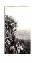
C IHCKA~IA l"GA lli,U'I', T.OOKOCT >IOU'11'AI:-;, WALKER COL"XT\" GEORGI A , SHOW IXC .\ TYPICAL DI.l:l'l' OF I.OO KOvT SA ::-; D:;T0 ::-;1,;.
GEOLOGICAL SURVEY OF GEORGIA
W. S. YEATES, State Geologist
BULLETIN No 12.
A PRELIMINARY REPORT
ON THE
COAL DEPOSITS
OF
GEORGIA
BY
. S. W. McCALLIE Assistant Geologist
GEO. W. HARRISON, STATE PRINTER
FRANKLIN PRINTING AND PUBLJSHT!\G COMPANY
Atlanta, Georgia
THE ADVISORY BOARD
of the Geological Survey of Georgia
(Ex-Officio)
Hrs ExCELLENCY, J. M. TERRELL, Governor of Georgia
PRESIDENT OF THE BOARD
HoN. 0. B. STEVENS HoN. W. B. MERRITT HoN. R. E. PARK HoN. W. A. WRIGHT HoN. PHILIP COOK HoN. JOHN C. HART
. Commissioner of Agriculture Commissioner of Public Schools
. . State Treasurer Comptroller-General
Secretary of State Attorney-General
LETTER OF TRANSMITTAL
GEOLOGICAL SURVEY OF GEORGIA, ATI.ANTA, January 2nd, 1904.
To His Excellency, J. M. TERRELL, Governor,
SIR :-I- have the honor to submit a report by Mr. S. W. McCallie, Assistant Geologist, on the Coal Deposits of Georgia, to be published as Bulletin No. 12 of this Survey.
Very respectfully yours, W. S. YEATES, State Geologist.
(5)
TABLE OF CONTENTS
CHAPTER
THE CARBONIF.EROUS ROCKS OF GEORGIA . Fort Payne Chert Floyd Shale . . . . Bangor Limestone . Lookout Sandstone . Walden Sandstone .
Page
9
10
14 16 19
20
CHAPTER II TOPOGRAPHY . . . .
22
Sand Mountain . .
22
Lookout Mountain .
CHAPTER
III STRUCTURAl, GEOI,OGY OF THE COAL FIEI,DS Major Structural Features . . . Minor Structural Features . . .
CHAPTER IV THE CoAL DEPOSITS OF WALKER COUNTY .
34
Durham Coal Mine . . . . . . .
34
Description of Individual Properties
42
CHAPTER V THE CoAL DEPOSITS oF CHATTOOGA CouNTY
ss
Description of Individual Properties . .
ss
CHAPTER VI THE COAL DEPOSITS OF DADE COUNTY
6r
Description of Individual Properties .
6r
CHAPTER VII CORREI,ATION NOTES
96
Lower Coal Measures .
99
Upper Coal Measures .
IOS
CHAPTER VIII DISCUSSION OF THE CHEMICAL PROPERTIES OF THE
GEORGIA COALS .
. . . . . . . . . . I I4
(7)
T E N N E s s EE
_j
LEGEND
~ Walden
~ S.mastone ~ LooKout
~ Sandstone
~ Fort PaynP
~ Chert
. S t lur ta n
00]] Cam brran
Scale M Jes
B
D
Map Showing the. Distribution of lhe Coal Measures of Northwt>s t Georgia, togethe r with the Associated Ro(ks.
THE COAL DEPOSITS OF GEORGIA
CHAPTER I
THE CARBONIFEROUS ROCKS OF GEORGIA
The Carboniferous rocks of Georgia are confined to the northwestern part of the State. They are best developed in Dade, Walker and Chattooga counties; though considerable areas occur in Floyd, Gordon, Whitfield and Catoosa. In addition to the above areas, there are four or five small isolated patches of the lowest member of the Carboniferous rocks, in the western part of Polk county.r The latter exposure appears to be a remnant of once extensive Carboniferous strata, covering much, if not all, of the Paleozoic area of Northwest Georgia. The superficial extent of the several areas of Carboniferous rocks, here enumerated, aggregates about soo square miles, which is only a fraction of the entire original Carboniferous area of the State.
The Carboniferous rocks of Georgia have been divided by Dr. C. W. Hayes, of the United States Geological Survey, into the following five divisions, named in the ascending order: Fort Payne Chert, Floyd Shale, Bangor Limestone, Lookout Sandstone and Walden's Ridge Sandstone. 2 The three first divisions, here given, belong to the Sub-Carboniferous series; while the two remaining divisions constitute the Carboniferous formation proper, or the Coal Measures.
I See Map opposite page 16. 2 Geologic Atlas, Ringgold Folio, U.S. Geol. Surv.
(9)
IO
THE CARBONIFEROUS ROCKS OF GEORGIA
THE FoRT PAYNE CHERT, the lowest member of the Sub-Carboniferous rocks, takes its name from Fort Payne, Alabama, at which place it is typically developed. The formation corresponds to Safford's Siliceous Group of Tennessee,' and to Smith's lower division of the Sub-Carboniferous rocks of Alabama, 2 which he designates as Lauderdale or Keokuk Chert.
The Fort Payne Chert, as defined by Hayes, rests directly upon the Devonian Black Shale, and is limited above, by the Floyd Shale, or, where that formation is wanting, by the Bangor Limestone. The upper limit of the formation is often difficult to define. Especially is this true, where it is overlain by the Bangor Limestone. In such cases, it passes gradually into the purer limestone above, without any sudden or abhtpt change. Under such conditions, it is often practically impossible to estimate the exact thickness of the formation. This accounts, in a great measure, no doubt, for the wide variation in the estimated thickness of the formation in Northwest Georgia. Hayes, who has made quite a study of the Paleozoic rocks of Georgia, Alabama and Tennessee, places the maximum thickness of the Fort Payne chert at 200
feet, while Spencer places it at sro feet.3 The former estimate,
according to my own observation, seems to be more nearly correct. However, the average thickness of the formation in Northwest
Georgia would probably not exceed rso feet. At some points in
Catoosa county, and also in Whitfield, the Fort Payne chert is
reported to attain a thickness of not more than so feet.
The Fort Payne chert is a siliceous, calcareous formation ; and, as the name suggests, it carries a large quantity of cherty material. The lower beds of the formation, in places, often consist almost entirely of chert in the form of layers, varying from one to two
1 Geology of Tennessee, pp. 339-351. 35. 2 Tennessee Valley Region, Ala. Geol. Surv., page
3 Geol. Surv. of Georgia, The Paleozoic Group, page 52.
THE CARBONIFEROUS ROCKS OF GEORGIA
II
feet in thickness. These layers frequently have an aggregate thickness of more than 20 feet ; and, at some points, where the underlying shales have been removed by erosion, they give rise to perpendicular bluffs, from IS to 20 feet in height. The chert, forming the individual layers at the base of the formation, is sometimes quite compact; but it is generally of a porous nature, and frequently consists largely of fragments of crinoid stems. In passing along the lower to the upper beds of the formation, the cherty material gradually decreases in quantity, until it finally disappears entirely, or is represented by only a few scattered nodules in the almost pure limestone.
The limestone, which makes up the great mass of the Fort Payne formation, is in most cases quite siliceous; but, at some points, it consists of beds of almost pure calcium carbonate. Limestone, of the latter character, is to be seen at the quarry near Rising Fawn furnace, where large quantities of the stone were formerly obtained for fluxing purposes. Some beds of the limestone often contain little or no cherty nodules; nevertheless these beds, in many places, are found to carry a high percentage of silica. The siliceous material, in this case, is found, upon microscopic examination, to occur in the form of minute particles, forming small clusters or bunches, irregularly distributed throughout the calcareous mass. In the weathering of beds of this character, the surface often becomes encrusted, to the depth of a quarter of an inch or more, with a dark brown or chocolate-colored coating, consisting mainly of silica. The weathered product, when powdered, forms a very fine, sharp grit, partaking of the nature of tripoli. The following is a chemical analysis of a specimen of Fort Payne limestone, showing microscopic clusters of siliceous particles, made in the Survey laboratory, by Dr. Thomas L. Watson, formerly Assistant State Geologist:-
12
THE CARBONIFEROUS ROCKS OF GEORGIA
Calcium Carbonate __________ ---------------- 3744 Magnesium Carbonate ________________________ 2595 Iron Sesqui-oxide_______________________ ____ o.69 Alumina___________________________________ 1.38
Insoluble Residue_------ _____ --------------- 3549 Total ______ ~ ____________ ------ _____ - ____ I oo. 95
Associated with the lower beds of the Fort Payne chert, often occur thin layers, or partings, of shale, varying from a few inches to a foot or more in thickness. These shales usually have a greenish color, and weather into a tough plastic clay.
The most marked, distinguishing cliaracteristic of the Fort Payne formation is the great abundance of chert. This material is always quite plentiful along the outcropping of the formation ; and it often covers the surface to the depth of several feet. This chert is readily distinguished from the Knox Dolomite chertt which it frequently closely resembles, by being fossiliferous. The fossils consist mainly of the fragments of crinoid stems; though coral and other organic remains sometimes occur. In weathering, this cherty material breaks into irregular fragments, well suited for road-surfacing.
The distribution of Fort Payne chert in Northwest Georgia is confined to narrow bands or zones, outcropping along the base of the mountains and ridges, formed of Carboniferous strata. It is well exposed at the base of Sand, Lookout and Pigeon mountains, and Taylor's ridge, as well as along the foot of Horn, John's and Lavander mountains, further to the east and s<;mth. As a general rule, the outcropping of this formation, owing to the slow weathering of its siliceous materials, gives rise to a narrow, sharp, serrated ridge, or chain of hills, running parallel with the main mountains, or ridges. In some instances, these hills, or minor ridges, sit back quite a distance from the base of the major ridges~ or mountains, in which case, there is always a narrow, fertile valley intervening. The ridges, formed by the Fort Payne chert,.
THE CARBONIFEROUS ROCKS OF GEORGIA
13
sometimes attain an elevation of 400 or soo feet above the general level of the valley; and, at many points, they have received local names which are usually of a descriptive nature. 1'hus, Pudding ridge, of Dade county, and Shinbone ridge, of Walker, are names given to the more prominent parts of these cherty ridges.
Economically considered, the Fort Payne formation of Northwest Georgia has been supposed, heretofore, to be of but little commercial importance. With the exception of its chert, which is now being used to a considerable extent for road-surfacing, probably the most important material, of economic interest, in the formation, is its fire-clays. These clays, having resulted from the weathering of the more siliceous beds of the formation, are frequently found in considerable quantities along the slopes of the cherty ridges. A good exposure of a clay deposit, of this character, is to be seen in some old prospect-pits near the Alabama Great Southern Railroad, about one mile south of Rising Fawn. Just .across the Alabama State-line, in the vi"cinity of Valley Head, are located the extensive fire-clay mines belonging to the Montague Clay Works, of Chattanooga. The clays here exposed are similar to those occurring near Rising Fawn, and have a like origin. Dr. Reis, in describing the clays at the former place, says: "Several -qualities of clays are obtained from the mines; but they are not restricted, in any case, to certain layers. The following sample, tested, is what is known at the mines as the first-grade, and its -refractory character is not by any means low.'' 1 The sample, here referred to by Dr. Reis, was a rather coarse-grained, white, sandy .clay, showing the following chemical composition : ~
1 Geol. Surv. of Ala., Clays of Alabama, by Heinrich Reis, page 147.
THE CARBONIFEROUS ROCKS OF GEORGIA
Silica____________________________________ _ 82.040 Alumina _________________________________ _ I2.IJO Ferric Oxide------------------------------ trace Lime ________ --- - - . _- -- . - .. - ------- -- --- ---- trace Magnesia __________________ .. _____________ _ 327 Alkalies _________ . ________________________ _ .6oo Ignition __________________________________ _ 4-325
Total ________________________________ _ 99462
Associated with the refractory clays here described, often occur potter's clay and halloysite. The last named mineral, according to Spencer,' is found on the Blivens property near Rising Fawn,. and on the east side of Taylor's ridge, in the vicinity of Subligna. In addition to the clays, the Fort Payne chert, in places, carries impure deposits of limonite. These deposits, however, are usually of limited extent, and appear to be of but little commercial importance.
Gypsum, in the form of small pockets or nodular masses, also occurs at a few points in the siliceous limestones of the formation. Good hand specimens of this mhteral may be collected from the dump at the west end of the railroad tunnel at Pigeon mountain.
THE FLOYD SHALE.- The Floyd Shale, as is above stated, lies immediately above the Fort Payne Chert, and is so called from the county of Floyd, where it is well developed. The formation~ which is always valley-making, covers a considerable area both in Chattooga and in Floyd counties ; and, according to Spencer, it has a thickness of r,soo feet. 2 The Floyd Shale, as the name implies, consists chiefly of shales; though, in places, limestone, and even sandstone, occurs. The latter beds are well developed in Alabama, where they are termed "Oxmore Sandstone." The shales, which are of a yellow or black color, are often quite calcareous ; and, in places, they become very fossiliferous. The calcareous type, of this shale, is well developed in West Armuchee
1 Geol. Surv. of Georgia, The Paleozoic Group, by J. W. Spencer, p. 212. 2 Ibid., p, sz.
THE CARBONIFEROUS ROCKS OF GEORGIA
IS
valley, in the vicinity of Green Bush, where it is associated with thin beds of limestone. Both the shale and the limestone in that district are often highly fossiliferous, the most abundant remains being blastoids and bryozoa. The former fossils are usually siliceous, and, at some points, they are found in considerable abundance in the residual clay; while the latter are of a more calcareous nature, and occur as delicate markings embedded in the partially weathered shale. In addition to these fossils, corals and bivalves are also quite plentiful; and occasionally they are well preserved. The district, here referred to, is probably the best locality to be found anywhere in the State for the collection of fossils from the Floyd Shale horizon.
The black shale of the formation differs from the above shale, not only in color, but also in the lack of fossils and calcareous material. The black shale is highly carboniferous, and it is often difficult to distinguish it from the Devonian black shale, which it frequently closely resembles. At some points, as in the vicinity of Sugar valley, this black shale has been taken as an indication of coal, and has been prospected at considerable expense by drilling. Hayes, in speaking of the sandstone of the Floyd Shale, says:-" East of Taylor's Ridge, there is a thin-bedded, more compact sandstone, sometimes highly fossiliferous, which passes gradually into the Floyd shales above and below." r In Te:X:as valley, this sandstone gives rise to two ridges running parallel with the Fort Payne chert ridges.
The one mineral, of economic interest, associated with the Floyd shale, is the brown-iron ore. This ore, which has been somewh.at extensively worked on the east side of Horn mountain, a short distance west of Sugar valley, occurs near the base of the formation; and, in places, it probably belongs to the Fort Payne chert. Brown-iron-ore deposits, similar to the above, are also to
1 Geology of North-East Alabama and Adjacent Portions of Tennessee and Georgia, p~ 47.
THE CARBONIFEROUS ROCKS OF GEORGIA
be seen in Redwine Cove, about three miles northwest of Carbon<lale.
THE BANGOR LIMESTONE.-The Bangor Limestone, in the absence of the Floyd shale, lies immediately above the Fort Payne chert. The formation corresponds to Safford's Mountain Limestone of Tennessee, and to Smith's Upper Sub-Carboniferous division of Alabama. The Bangor Limestone consists of blue and gray, heavy-bedded limestones, with a few thin beds of shale. The shales, which are usually of a green or red color, occur chiefly near the top of the formation, where they seem to mark a transitional stage between the calcareous deposits below and the argillaceous <leposits above. Some of the layers of limestone occasionally contain a small amount of siliceous material, in the form of cherty nodules; though, as a general rule, the beds consist almost entirely of pure limestone.
The formation is quite fossiliferous throughout; but the organic remains are most abundant in the upper beds, which are made up mainly of clayey limestones. An excellent place, for collecting specimens of fossils from these limestones, is at the old lime quarry in Nickajack gulch, a short distance below the coke ovens at Cole City. The most abundant fossils ot the Bangor limestone are blastoids, bryozoa and coals. Perfectly preserved blastoids, more than r I-2 inches in length, were picked up at the above named quarry. Cup corals, and a number of species of bivalves, all well preserved, are also to be found at t?is point, associated with which are innumerable fragments of Archimedes, a spiral-sh~ped coral, formed by bryozoa.
The thickness of the Bangor limestone in North Georgia, varies from soo to 700 feet. It reaches its greatest development at the Georgia-Tennessee State-line, near Chattanooga, from which point it gradually decreases in thickness to the south and east. In the head of Johnson Crook, three miles east of Rising Fawn, accord-
MAP
SHOWING
THE DISTRIBUTION
or
CARBONIfEROUS STRATA
IN
GEORGIA
THE CARBONIFEROUS ROCKS OF GEORGIA
IJ
i.ng to my own measurements, the formation attains a thickness of 525 feet; while, just across the State-line at this point, in Deer Head Cove, Alabama, McCalley places the thickness at 400 feet.
The great difficulty, in estimating accurately the thickness of the Bangor limestone, lies mainly in defining its upper and lower limits. Below, it passes by a gradual increase of siliceous materials into the Fort Payne chert; while above, its change into the overlying calcareous shales, in places, is equally gradual. There is rarely ever any well defined line either above or below, that can be taken as marking the upper and the lower limits of the formation; and, as a result, different observers will naturally assign to the formation different thicknesses. Should all the limestone, lying between the lowest coal seam and the Fort Payne chert, be included in the Bangor Limestone, the formation in the vicinity of Cole City would attain a thickness of more than 900 feet ; I but, Dn the other hand, if it were limited to the first heavy beds of shale, it would be reduced to less than 6oo feet. Spencer's estimate of the thickness, which he _places at 900 feet, 2 can be ac~ounted for, only by assuming that his measurements were made from the uppermost layer of limestone in the shales near the first coal seam.
Lithologically considered, the_ upper beds of the Bangor Limestone may be said to be limited by the first thick beds of shale DverlyinR the blue limestones. These beds, above which only thin layers of limestone occur, vary from 125 to 300 feet beneath the lowest coal seam.
The distribution of the Bangor limestone, like the Fort Payne ~hert, occurs in narrow strips along the flanks of Sand, Lookout and Pigeon mountains. It is also found in small detached areas
in White Oak mountain, which is the northern extension of Tay-
I See Ferndale section.
2 Geol. Surv. of Georgia, The P.zleozoic Group. by J. W. Spencer, p. 52.
18
THE CARBONIFEROUS ROCKS OF GEORGIA
lor's ridge, and in Rocky and Little Sand mountains, east of Taylor's ridge. The formation at no place, with the exception of the exposure at the north point of Pigeon mountain, exceeds a mile in breadth. The extreme narrowness of the outcropping of the Bangor limestone is due to the formation being protected above by heavy beds of sandstone and conglomerate, which weather extremely slowly. In a few instances, the formation forms narrow, fertile valleys, between the base of the mountains and the Fort Payne chert ridges; but, generally, it is confined to the steep slopes of the mountains themselves, where it gives rise to deep, rich soils, often covered with a heavy growth of red cedar.
At some points on the mountain slope, owing to the thick mantle of talus derived from the sandstones and shales above, but little or no exposure of the Bangor limestone is to be seen; while, at other points, where the talus is wanting, it is very abundant, and occasionally forms bluffs several feet in height. Along these bluffs, and about the large exposures, are frequently to be found springs flowing from subterranean caverns. These caverns are quite common along the slopes of both Sand and Lookout mountains; and, in a few instances, they are reported to have been explored for long distances. The entrance to one of these caves, which has attracted some local interest, may be seen on the roadside at the foot of Sand mountain, about I I-2 miles southwest of Trenton.
The economic value of the Bangor limestone may be said to be confined chiefly to its purer beds of limestone, which are well suited for building and fluxing purposes, as well as for the manufacture of quick-lime. ~xcellent building-stones, of almost any dimension, can be obtained from these beds at numerous points along the slopes of either Sand or Lookout mountains. The stone is partially crystalline, and is generally quite free from chert and other impurities. The large quarry at Nickajack gulch, from
THE CARBONIFEROUS ROCKS OF GEORGIA
which considerable quantities of stone were formerly quarried for furnace purposes, testifies to its value as a fluxing material.
The three Sub-Carboniferous formations, above described, il].clude all the rocks in Georgia belonging to Prof. H. S. Williams's Mississippi series. Williams, in his discussion of this group of rocks, says :-' "This series may be defined stratigraphically as that series of rocks prevailingly calcareous, which occupy the interval between the Devonian system and the Coal Measures, and is typically developed in the States forming the upper part of the valley of Missouri, Illinois and Iowa.'' This author thinks, that the division of these rocks into groups is worthy of attention. However, he expresses the opinion, that such divisions cannot be final until the faunas are more thoroughly studied.
THE LOOKOUT MouNTAIN SANDSTONE.-The Lookout Mountain Sandstone, which corresponds to Safford's Lower Coal Measures, consists of sandstones, conglomerates and shales, coal, and a few thin layers of limestone. The formation varies in thickness in Northwest Georgia from 300 to 400 feet. Its upper limit is defined by a heavy bed of conglomerate often seen forming the uppermost cliffs along the margin of Sand and Lookout mountains. The upper beds of the Lookout formation are made up chiefly of sandstone, with thin beds of argillaceous shale~ and from . two to five coal seams. The sandstone, in places, is coarse-grained; and it occasionally passes into a conglomerate. It is often crossbedded ; and, at some points, it shows numerous impressions of fossil plants. The shales, associated with the sandstone of the upper beds of the Lookout Mountain formation, are of a dark, or almost black, color. Some of these argillaceous beds carry considerable iron carbonate in the form of nodular concretions. A good example of a bed of this character is to be seen in Johnson Crook, just beneath the lowest coal seam.
1 Correlation Papere-Devonian and Carboniferous, But. No. So, U. s. Geol. Surv., page 135.
20
THE CARBONIFEROUS ROCKS OF GEORGIA
The lower portion of the Lookout Mountain formation consists of red and gray shales, with a few thin beds of sandstone and limestone. The shales, forming the upper part of the lower division of the Lookout formation, are usually quite sandy; while those beds occurring at a lower horizon are distinctly argillaceous. Associated with the latter shales, are a few thin beds of limestone. These calcareous beds increase in numher, as the Bangor Limestone is approached. At some points along the western slope of Lookout mountain, the sandy shales above referred to, contain numerous fossils, the most abundant being bryozoa and fragments of crinoid stems.
The Lookout Mountain Sandstone, in Northwest Georgia, forms the surface rock along the margin and the upper slopes of Sand and Pigeon mountains. It caps Rocky and Little Sand mountain east of Taylor's ridge, and occurs in a small isolated area northeast of Ringgold, near the Georgia-Tennessee State-line. The total exposed area of the Lookout Mountain formation in Northwest Georgia is estimated to be about 30 square miles.
THE WALDEN SANDSTONE.-The Walden Sandstone, so called from Walden's ridge, Tennessee, where the formation is typically developed, lies immediately above the Lookout Mountain Sandstone, and forms the cap rock of Sand, Lookout and Pigeon mountains. It covers a total area in Northwest Georgia, of about 170 square miles, and is confined entirely to the top of the above mountains. The formation, which is made up of sandstone, conglomerate and shale, with from two to seven seams of coal, attains its greatest thickness at Round mountain in the vicinity of the Durham coal mines. Its approximate thickness at that point h~s been placed by Hayes at 930 feet.'
The sandstones and conglomerates of the Walden formation
1 Geologic Atlas, Ringgold Folio, U.S. Geol. Surv.
THE CARBONIFEROUS ROCKS OF GEORGIA
2I
differ but little from the sandstones and conglomerates of the underlying formation. The shales are also quite similar; but, as a general rule, the Walden shales are more micaceous and sandy; and, at the same time, they are more fossiliferous; especially is this true of the shales associated with the coals.
CHAPTER II
TOPOGRAPHY
The topography of the coal-fields of Northwest Georgia is typical of the Cumberland Plateau region of Alabama and Tennessee. The most distinguishing physiographic feature of the area is the broad, more or less flat-top mountains, with their precipitous marginal cliffs rising from 8oo to 900 feet above the valleys. Two of these mountains, namely Sand, or Raccoon, and Lookout, traverse the extreme northwestern corner of the State.
Sand Mountain, which is the southern extension of Walden's ridge, lies the furthest to the west, and is separated from Lookout mountain by Lookout valley. This mountain in Georgia has a maximum width of about six miles. Its surface, along the yeorgia-Alabama State-line, is comparatively level; but, to the northeast, it becomes broken, and is deeply indented by Nickajack and Richmond gulches, the former on the west, and the latter on the east side of the mountain. North of these gulches, Sand mountain loses, in a great measure, its plateau character, and consists of irregular ridges and hills extending to the Georgia-Tennessee State-line.
The eastern brow of Sand mountain, which has a northeastsouthwest trend, consists of a line of sandstone bluffs forming the western boundary of Lookout valley. These bluffs are generally two in number, one rising above the other. They vary in height from 30 to So feet; and, when viewed from the valley below, they have the appearance of a huge wall, with now and then a gap or break, through which the summit of the mountain can be gained.
(22)
TOPOGRAPHY
23
Below the sandstone cliffs, the slopes of the mountain become more gradual, though even here, in places, the slope often becomes quite preci pi to us.
The western side of Sand mountain, which lies beyond the Georgia-Alabama State-line, differs from the east side mainly in having a more irregular boundary, due to the presence of large gulches, that have cut their way far back toward the center of the mountain. One of the largest and most noted of these gulches, is Nickajack, a narrow canon-like gorge extending from the GeorgiaTennessee State-line, near Shellmound, to the southeast, some distance beyond the main axis of the mountain. The total length of this gorge, which, in places, is contracted to a width of less than 100 yards, is about 4 1-2 miles; while its <;Jepth varies from 6oo to 700 feet. The scenery of this gorge is wild and picturesque. Especially is this true, near its head in the vicinity of Cole City, where it becomes much contracted, and is walled in on both sides by high sandstone cliffs extending up to the top of the mountain.
In passing northward from the above point, in the direction of Shellmound, the continuity of the sandstone bluffs are interrupted by the entrance of minor gorges from the right and the left. These minor gulches usually extend back from the main gulch only a short distance, where they terminate abruptly in one or more high sandstone cliffs, which often mark the place of small waterfalls. The diversity and the beauty of the scenery, which would other-
wise be somewhat monotonous, is d~e, in a great measure, to these
minor gulches. Lookout.mountain differs from Sand mountain chiefly in being
much narrower, and in rising to a somewhat greater elevation. It may be defined as a long, narrow, comparatively flat-top, synclinal mountain with steep slopes, deeply indented by a number of prominent gorges. The mountain, which varies from one to five miles in width, has a northeast-southwest trend, and an average
24
TOPOGRAPHY
elevation of about r,qoo feet above Lookout and Chattanooga valleys. At a few points, its summit reaches a height of more than r,2oo feet above the valley; but such elevations are always confined to small areas, or isolated peaks.
Near the Georgia-Alabama State-line, Lookout sends off to the northwest a very prominent spur, known as Pigeon mountain. This mountain, which is separated from the main mountain by McLamore's Cove, the southern extension of Chattanooga valley,. has a length of about ten miles. Pigeon mountain, like Lookout, has a comparatively flat top and steep sides. It varies from 6oo to r ,ooo feet in height, and from an eighth of a mile to three miles in width. Its eastern side is indented by several deep gulches, which have been formed by small streams flowing from its summit.
North of the above spur, or subordinate mountain, the eastern brow of Lookout continues to the Georgia-Tennessee State-line, a. distance of nearly 30 miles, with only a few breaks in the walllike sandstone bluffs, which form its summit. Along this nearly straight stretch of sandstone bluffs, are to be seen a few isolated peaks rising from 200 to 300 feet above the general level of the mountain. The most prominent of these are High Point and Round Top, the former north, and the latter south, of a break in the bluffs, known as Moore Gap. Round Top, as the name suggests, is nearly circular ; and, owing to its isolation, it forms one of the most conspicuous prominences to be seen at any point along the east brow of the mountain.
High Point differs from Round Top in being much elongated, and in having steeper slopes. The summit of the former peak, which is the highest point on Lookout, attains an elevation of 2.392 feet above sea-level. Its eastern side is a sheer precipice of sandstone cliffs, continuous with the bluffs, forming the brow of the mountain to the north and the south. The top of the peak, in places, is very rugged, being covered by immense sandstone
TOPOGRAPHY
bowlders, the remnants of a once continuous stratum, formerly capping the top of Lookout.
A few miles north of High Point,. occurs another prominence on the eastern brow, known as Eagle Cliff. This elevation, though not so high as the two eminences further to the south, is quite conspicuous when viewed from the valley below, on account of its high, bold, sandstone bluffs, which seem to stand out from the main mountain. These bluffs, forming Eagle Cliff, continue to the north for about two miles, where they are terminated abruptly by the deep gulch formed by Rock creek, a stream of considerable size, having its source on Lookout mountain, some miles to the south.
Rock Creek gulch, which is also known as McCallie gap, is on the eastern brow of Lookout. It presents the wildest and the most picturesque scenery, anywhere to be seen on the east brow of Lookout. The gulch, at its mouth, is a deep chasm, several hundred feet in depth, walled in on both sides by huge cliffs of massive sandstone. The sandstone cliff to the south, formed by the northern extension of Eagle cliff, is much broken, and the rocks along its summit, in places, stand out as bold, isolated pinnacles. In contrast with this, the north side of the gulch is formed by an unbroken wall of sandstone continuous with the long line of sandstone bluffs to the north. Within this gulch, where these two lines of sandstone cliffs unite, is located Lula falls, and just beyond, Lula lake. The falls, which reach their descent in a single plunge, have a height of about 6o feet. The lake is a large, deep, circular pool, or pot hole, 75 feet or more in diameter, scooped out of the hard sandstone rock. Its quiet and placid waters present a marked contrast with the roaring waters of the falls below. Beyond the lake, the sandstone cliffs give way to steep slopes, where Rock creek runs in a narrow V-shaped gorge, which extends southward to the Durham coal mines, a distance of about 7 miles. North
TOPOGRAPHY
of McCallie gap, the sandstone cliffs continue to the Georgia-Tennessee State-line with but few breaks.
The west side of Lookout has generally a more precipitous slope and higher bluffs than the east side. Especially is this true of the northern part of the mountain, in the vicinity of the Georgia-Tennessee State-line. The sandstone bluffs are also more continuous, and not so often interrupted by deep gulches. From the GeorgiaTennessee State-line, on the east side of the mountain to Trenton or Sitton gulf, a distance of more than r 2 miles, there is scarcely a break in the bluffs; and, at only two or three points, are there trails leading from the top of the mountain to Lookout valley below. The sandstone bluffs are unusually bold, and the slopes of the mountain below are, at the same time, steep. : Trenton gulf above referred to, is a deep cafion, formed by Bear creek, which takes its rise near the eastern brow of the mountain. The main part of the gulf, which varies from 6oo to Soo feet in depth, is about two miles in length. Its walls are steep; and, in places, they are formed of sandstone cliffs, 200 or 300 feet in height. A view of the gulf from the summit of these cliffs is excellent; and it reminds one very much of a view of Tallulah gorge in Rabun county.
To the south of Trenton gulf, is another gulf of much larger size known as Johnson crook. This gulf, which is really the northern extension of Wills' valley, Alabama, cuts a deep, broad gash into the western side of Lookout. It is surrounded on all sides, except to the south, by a long line of sandstone cliffs, which mark the western brow of the mountain. South of Johnson crook, are Forester's and Tatum's gulches, both breaking the continuity of the sandstone bluffs, which continue in an almost straight course to the Georgia-Alabama State-line.
The surface of Lookout mountain, though generally spoken of as being level, becomes, in places, irregular and somewhat broken.
TOPOGRAPHY
27
Especially is this true, in the neighborhood of the streams. The brow of the mountain, at most points, has a slightly greater elevation than its center, which thereby gives to the mountain the form of a shallow trough. The peculiar topographic features of the mountain become most striking, when viewed from the high points on the east and west brows. The streams of the mountain, on account of its trough-like form, are confined largely to the main axis of the mountain; and they are enabled to reach the valley below, only by cutting deep channels through the elevated brow. At one point on the mountain, near the sources of Rock and Bear creeks, where denudation seems to have acted very slowly, is a lonely, isolated elevation, 300 feet in height, known as Round mountain. The top of this mountain rises to a somewhat greater elevation than the brow to the west; but, on the east brow, High Point and Round Point attain a some\vhat greater height ; so that, even at this point, the mountain may be said to still retain its trough-like form.
CHAPTER Ill
STRUCTURAL GEOLOGY OF THE COAL FIELDS
The structural geology of the coal fields of Georgia is quite simple. The Carboniferous and the underlying strata, which were formerly laid down as horizontal beds of sand, clay etc. on the sea bottom, have been changed by lateral pressure into a number of huge anticlinal and synclinal folds, having a northwest-southeast trend. One of the most prominent of these folds, is the Lookout syncline, forming Lookout mountain. This fold, which has its northern terminus in Tennessee, traverses the northeastern corner of Georgia, and continues southward into Alabama. The width of the fold, as measured by the limits of Lookout mountain, varies from one to five miles. Its greatest width is just south of McLamore's cove, near the Georgia-Alabama State-line, from which point it gradually decreases in width to the north. With a few local exceptions, the fold is quite symmetrical; that is, the strata from both sides of the mountain dip at about the same angle towards the axis of the fold .
At the head of McLamore's cove, the Lookout syncline sends off to the northeast a small secondary syncline, forming Pigeon mountain. These folds are separated from each other by the Chattanooga anticline, which terminates in the head of McLamore's cove, and extends northeast, along the east side of the mountain, to Chattanooga. East of the Pigeon Mountain syncline, and forming the eastern boundary of the southern extension of the Lookout syncline, is the Chattanooga anticline, which extends for many miles to the northeast.
(zS)
STRUCTURAL GEOLOGY OF THE COAL FIELDS
29
West of Lookout mountain, the structure here described 1s again repeated. To the extreme northwest, is the broad syncline of Sand mountain, followed by the Lookout Valley syncline, which stops short in Deerhead cove, thus separating from the main syncline, the Fox Mountain syncline, a counterpart of Pigeon mountain, which, in turn, is limited on the east by the Wills' Valley anticline. The structural geology of the coal fields, here outlined, will be readily understood by an examination of Hayes's outline map of this region. I
MINOR STRUCTURAL FEATURES AS SHOWN IN THE WoRKING oF THE INDIVIDUAL COAL SEAMS
In addition to the large structural features, above referred to, there are minor structural features, which have a very important bearing on the commercial value of the coal seams. These minor features, which are more or less common in all coal fields, may be grouped for convenience of description under the headings, .folds, faults, and irregularities in the thickness of beds. The first two divisions, here mentioned, are dne to movements in the earth's crust, subsequent to the formation of coal; while the other may be due to the same cause, or to the irregular deposition of the coal itself.
In the formation of the huge anticlinal and synclinal folds, heretofore described, there were produced, at the same time, an indefinite number of small folds. These minor folds, which often seriously interfere with mining, are quite irregular in their distribution. At some points, they are entirely absent, and the strata extend for long distances practically level; while, at other points, they are more or less abundant, and the strata appear in wave-like undulations. The width of the individual folds, like their height, is quite variable. In some instances, they may measure roo feet,
I See Bull. No.4, Ala. Geot. Survey.
30
STRUCTURAL GEOLOGY OF THE COAL FIELDS
or more, from crest to trough; but, as a general rule, the width is limited to a few rods.
These minor folds interfere with mining in two ways. In the first place, they interfere with the drainage of the mines; and, in the second place, they often affect the uniformity of the coal seam itself. It will at once be understood, in what manner the folds hinder drainage, when it is stated, tpat the floor of the mines, where the folds occur, is always undulating and otherwise more or less irregular. In such cases, the only way to make the mines self-draining is to connect the troughs of the several folds by tunnels or cross-cuts. I
Fig. r.
l
Section Showing Undulations in Coal Seam. Also, the Thickening and Thinning of the Seam Itself.
The effect of the folds on the uniformity of the coal seam itself is also well illustrated by the same figure. The thickness of the coal seam on the side, or near the center of the trough of the fold, as here represented, is generally greater than it is at the crest. This irregularity in thickness seems to be largely due to the flowing or movement of the coal, under great pressure, from the crest to the trough of the fold, subsequent to its deposition, and at the time the mountains themselves were being formed. At some points, the coal seam at the crest of the fold is said to be reduced in thickness to a few inches, called a ''squeeze''; but, in such cases, the seam in the adjoining trough is generally correspondingly thickened. These "squeezes," as is shown on the map of the Slope and the Rattlesnake mines, always have their longer axis running northeast and southwest. A good example of the enlargement of
I See fig. r.
STRUCTURAL GEOLOGY OF THE COAL .FIELDS
31
the coal seam in the trough of a fold is said to occur in the Elijah mine at Cole City, where the Dade coal seam at one point attains a maximum thickness of 17 feet. Besides the thickening and the thinning of the coal seams, here described, sharp or abrupt folds sometimes gives rise to another structure shown by Fig. 2. In this case, the overlying shale at one point has been broken, and the coal has apparently flowed, or been forced up, into the fissured sandstone above.
Fig. 2. Vertical Section Showing Irregularity in Coal Seam.
1
Small faults, of a few feet throw, are reported to occur in the different mines in the vicinity of Cole City; but. none of them were examined by the writer. Displacements of this character, however, were noticed along the narrow-gauge road between Cole City and the coke ovens. The best exposure of these faults is to be seen along the sandstone bluff, just north of the coal chute, which extends from the top of the mountain to the coal-washer in the gulch. In no case, do these faults represent a displacement of more than a few feet.
The thinning and thickening of coal seams, due to irregularity in deposition, is well illustrated by the Castle Rock seam in the Cole City district. I This seam, at the old Castle Rock mines near . the Georgia-Alabama State-line, where it was worked for several years, attains a thickness varying from three to four feet; but, to the east of these mines, the seam decreases in thickness, so that, in the vicinity of Cole City, it is reduced to a few inches, or is entirely wanting. Similar variations in thickness, which can be
I See fig. 3
32
STRUCTURAL GEOLOGY OF THE COAL FIELDS
Fig. 3.
MAP
OF
CASTLE ROCK MINE.
SHO.WINC
SQ. U E EZES"
SECTIONONAB
accounted for only by irregularity in deposition, are also met with, in the Dade and Rattlesnake seams of the same district. Dr.
J. W. Spencer, in speaking of these variations, says: r "Whilst
the Coal Measures occupy a long, synclinal trough, yet the individual beds are separated into basins of various extent, and represent the individual marshes of the Carboniferous period, when the region was occupied by extensive swamps more or less separated by such hammocks as rise in the extensive swamps of Florida today. These changes in the surface features gave rise to thinning and thickening of the coal beds. Yet many of the deposits, although separate, had doubtless a synchronous origin." Major
1 Geol. Surv. of Georgia, The Paleozoic Group, p. 253.
PI.ATF, Ill
l ' I'I'J(I{ 1'.\I.J,S, I,I' I,A f,AKI: , 01': 'l'I! H l}t;RH .\;\1 RJ\TI,ROAD, WA I.KER <.:Olil'ITV, C!lORC. IA, SII0\\'1:'\C 1\:-< I: Xl'USURE OJ' I.OUI.(OliT SAXDS'r0;'\1:.
STRUCTURAL GEOLOGY OF THE COAL .FiELDS
33
M. T. Singleton, Mining Engineer of the Georgia Iron & Coal Company, who has made an extensive study of the coal deposits of Sand mountain, expresses similar opinions to the above, in regard to the variation of the coal seams in the Cole City district.
CHAPTER IV
THE COAL DEPOSITS OF WALKER COUNTY
The coal deposits of Walker county are confined to Pigeon mountain and the eastern side of Lookout mountain. The most valuable coal seams are those of the Upper Coal Measures on Lookout, in the vicinity of the Durham mines described below. In addition to these coal seams, there are others, of considerable promise, in the Lower Coal Measures. The latter, however, have been prospected only to a limited extent, and their commercial importance is in a great measure unknown.
THE DURHAM COAL MINES
The Durham coal mines, now operated by the Durham Coal and Coke Co., of Chattanooga, are located on Lookout mountain about 12 miles southeast of Chattanooga. The outcropping of the coal occurs here at the base of Round mountain, a small elevation having a maximum height of 300 feet above the general level of Lookout.
Round mountain, as the name suggests, is nearly circular ; although it is deeply indented on its north side by a gorge, formed by the head-waters of Rock creek.1 Taking the outcropping of the Durham coal seam as its base, the mountain measures nearly five miles in circumference. It is situated about equi-djstant from the east and west brows of Lookout, which are here more than five miles apart. The ascent of Round mountain from the south and west, is generally gradual; while, to the north and east, it
1 See Map.
(34)
S:c:;a:le;.,r;:~"""'.ttf:IJilf"Zr;~,n=JN'
Map of Round Mountain, \Valker County, Georgia,
THE COAL DEPOSITS OF WALKER COUNTY
35
becomes more precipitous. The surface of the mountain is by no means uniform. On the contrary, it is often furrowed by numerous small hollows, eroded mainly by the action of rain-waters, as they descended its slopes. Capping the highest point of the mountain, which lies only a short distance west of the present entrance to the coal mines, is to be seen a heavy bed of coarse-grained sandstone, or conglomerate, having a total thickness of something like 40 feet. The conglomerate, in weathering, has left on the surface, in places, huge, rounded bowlders, not unlike the erratic bowlders of the glaciated regions.
The view from the above point is excellent. To the west, some two miles away, is to be seen the western brow of Lookout, which seems to rise several feet above the intervening stretch of country. To the east, a similar view presents itself; though the elevation of the brow here seems to be more pronounced. Two of its highest peaks, namely, High Point and Round Top, are especially prominent, and rise from rso to 2oo feet above the point of view. Such a view clearly shows that Lookout mountain is here in the form of a shallow trough, with Round Top mountain near its center. The origin of this somewhat peculiar land-form has its explanation in the structural geology of Lookout mountain, which has been discussed under a separate head.
A workable coal seam has long been known to ou~crop at the base of Round mountain. At two or more points, it is said to have been worked, to. a limited extent, prior to the Civil War, when the commercial value of the coal was fully demonstrated by its use in the blacksmith forge. The old excavations at the base of the mountain on the south side, now known as Green's bank, are pointed out as the remains of one of these early workings. Much of the coal used 20 years ago in the blacksmith-shops, both on Lookout mountain and in the adjacent valleys, was obtained from Round mountain.
THE COAL DEPOSIJS OF WALKER COUNTY
Active mining operations might be said to have begun at Round mountain in r8gr, a few months previous to the completion of the Chickamauga and Durham railroad to that point. The first shipments were made in r8g2, since which date the mines have been in continuous operation. At the time of the writer's visit to Round mountain, the mines gave employment torso convicts and a limited number of free laborers. The daily output of the mines at that time was 700 tons.' Something like one-fifth of the total amount of coal, then produced, was manufactured into coke, and the remainder was used for steam and other purposes.
The Durham mines are well equipped with all the necessary machinery, needed to carry on successful and economic mining. The plant consists of a coal-washer, with a capacity of 300 tom per day; rso coke ovens, roo of which are located at Chickamauga; small locomotives, with which to handle the coal, both in the yard and within the mines; machine and blacksmith shops ; a commissary and an office building; residences for the superintendent and the physician; and numerous miners' cottages and convict barracks. The plant is located in the gorge at the entrance to the mines on the north side of the mountain. The location has been well selected; and, as a consequence, the entire coal seam can be worked without any special inconvenience from long underground hauls. Furthermore, the plant is located at a point, toward which the coal seam dips from all directions. This insures the least possible expense in delivering the coal to the tipple, and also in draining the mine. If the coal seam lay in a uniform plane, that is, not subject to undulations, the mine would not only be self-draining, but the coal could also be delivered at the washer by gravity.
There are four entrances to the mines, three on the west side of the gorge, and one on the east. The main part of the workings,
1 The output of the mines is at present abont r,ooo tons per day.
THE COAL DEPOSITS OF WALKER COuNTY
37
which includes au area of more than 200 acres, lies on the west side of the gorge beneath the highest point of Round mountain. At several places, on the opposite side of the mountain, where the ventilating shafts are located, the works extend to the surface. With the exception of about 50 acres on lot 298, owned now by the Lookout Coal & Coke Co., much of that part of the coal seam, lying directly west of the gorge, has been worked out. The workings east of the gorge are not extensive. The entire area, from which the coal has been taken, would probably not exceed 20 acres.
The amount of workable coal, still remaining in the Durham .seam, probably does not fall far short of r,ooo acres. This estimate is not a mere matter of conjecture; it is based upon the natural and the artificial exposures of the vein, which encircle the entire base of the mountain. The amount of coal, here practically in sight, is sufficient to keep the mines running for several years, at their present rate of output.
The Durham coal seam, in places, attains a thickness of 7 feet ; but its average thickness is not over 38 inches. The seam is divided near the center by a parting of slate, varying in thickness from a few inches to two feet. There appears to be little or no difference in the character of the coal above and below the slate, both divisions being made up of bright, clear coal, having a slight columnar structure when undisturbed. The seam, as previously stated, has a general dip toward the gorge or the center of the mountain, and it, therefore, lies in the form of a basin. The points, at which the greatest elevations of the outcroppings of the seam occurs, are on the east and the west sides of the mountain nearly directly opposite each other. These points have an elevation of about roo feet above the lowest outcrop of the coal in the gorge at the entrance to the mines.
The chemical composition of the Durham coal is shown by the
THE COAL DEPOSITS OF WALKER COUNTY
following analysis by Dr. Gustave Bidtel, formerly of Chattanooga, Tenn.:-'
Fixed Carbon _______________________________ 79.100 Volatile Matter_ _____________________________ 16.030 Ash -------------------------------------- 4.810 Sulphur ___________________________________ Q36o Phosphorus _____ _______ ________________ _____ o.oo7
Total _____________________________ -_---- 100.30Z
Another analysis, made for Mr. A. S. Hewitt, of New York, gives the following results : - 2
Fixed Carbon _____________________________ _ 75956 Volatile Matter ____________________________ _ 2I.OII Moisture __________________________________ _ 0.615 Ash (Salmon color) ________________________ _ 1.940 Sulphur __________________________________ _ .047
Total _________________________________ _ 99569
The above analyses show that the Durham coal is excellent for coking purposes. Its fixed carbon runs higher than the_ Pocahontas coal, and the amount of ash and sulphur present is unusually low. The coke manufactured from the Durham coal is hard, strong and highly cellular. Col. Gaines, General Manager of the Tennessee Coal & Iron Co.'s furnaces, at South Pittsburg, in speaking of this coke, says: "The coke made from-the Durham coal is of an excellent quality. I consider it equal to any coke manufactured in the south for furnace purposes."
The analysis of the coke made for Mr. A. S. Hewitt, of New York, is as follows : -
Fixed Carbon _______________________________ 90.31 Volatile Matter_______________________________ r. 20 Ash _______________ ________________________ 8.53 Sulphur------------------------------------ 0.53
TotaL __________________________________ 100.57
1 Geol. Surv. of Georgia, Tlze Paleozoic Group, by J. "\V. Spencer, p, 2.)8. 2 Ibid,, P- 259-
THE COAL DEPOSITS OF WALKER COUNTY
39
There are two other coal seams on
Round mountain, outcropping at a higher
elevation than the Durham seam. Both ss
of these veins, as shown by the section
below, are small veins, and, as a conse-
quence, have no commercial value. The
section here given includes the several S 5 ... S
beds of rock in the descending order,
together with coal lying above, and In-
cluding, the Durham seam:-
Coarse-grained, heavy-bedded Sandstone_________ 40 feet
Sandy Shale (partly concealed) _______________
so
"
Sandstone ______________ 40 "
Shaly Sandstone (partly concealed)-- __________ 120 "
Black Shale with thin part-
ings of CoaL _________ 12 "
Sandstone _____________ _ Coal __________________ _
IO
4
"
inches
Sandstone (cross-bedded) __ 6o feet Shale _________________ _ 20 inches
CShoaalle_____~_-_-_-_-_-_-_-_-_-_-_-_-_-_-_-_ Coal ___________________
22
8
20
"
"
"
Fire-clay_______________ 2 feet
S5 SS S
Fig. 4. ' J ..~
.'.
1-0' 50'
10'
IZfJ'
The geological section, here given, is on the west side of the gorge extending from the entrance to the mines to the highest point on the mountain. On the
opposite side of the gorge, and about ss
half-a-mile south of the convict barracks, near the public road leading to Cooper gap, are other exposures of these Upper Coal seams. The ~ower of the two is here
I 2.-'
10' . ! 4 ,~
60'
THE COAL DEPOSITS OF WALKER COUNTY
represented on the roadside by a streak of smut in the disintegrated sandstone overlying the Durham seam; while the other appears as thin partings in a bed of black shale. At the top of the black shale, near its contact with the overlying sandstone, the coal becomes more abundant; and, at one or two points, in some washes in an old, abandoned field, is to be seen along the hillslopes another exposure of coal, varying from 12 to 18 inches in thickness. The coal here exposed has a columnar structure and is apparently of fair quality, although the thinness of the seam renders it practically of little or no commercial value.
THE LooKouT CoAL AND CoKE CoMPANY's PROPERTY
This coal property, as is above stated, is located on lot 298, roth district, and embraces the northern extension of the Durham coal seam. By an examination of the map of Round mountain, it will be noticed, that the Durham coal underlies only about a third of
so the lot, or something like acres. This property, which was
formerly owned by Mr. E. W. Marsh, of Atlanta, was purchased by the above named company in the summer of 1900. Shortly after the property changed hands, the mine was opened; and it has been in continuous operation ever since. The company now employs
so about convicts, and also a limited number of free laborers. The
output of the mine at present is 200 tons of coal per day, which is used chiefly for steam and smithing purposes.
ExPOSURE OF CoAL IN RocK CREEK GULCH BETWEEN THE DURHAM MINES AND M'CALLIE GAP
The fi.rst exposure of coal in Rock Creek gulch, north of the Durham mines, is in a cut on the west side of the railroad, near the first mile-post. The exposure is located on lot 278, Ioth dis-
trict, which is owned by Mr. J. T. Buckhalter. The lot, however,
at the time of our visit, was under a 6o-day option to Dr. Robert
COAL DRPOSI7~\ OF GEOR GIA
1'1..1TJ; I V
1,0 \\" l;R 1'.\l, LS, I .U I,A I .~KH, ON '!'Ill: D U RII .\ ~ I R A I I. ROA D, \\'.\ I.K I: R COU!''J'\', G 1-:QRCJ .\ , SHO WI NG E XI'OSU IU : ( H' 'I'III CK H I:DDJW J.OO KOUT S.\NDSTO X I:.
THE COAL DEPOSITS OF WALKER COUNTY
Tatum, who was then engaged in prospecting the coal seam. I This coal seam is undoubtedly the same seam, that is reported to have been penetrated at the Durham mines in a bore-hole, at the depth of about ISO feet from the surface. The exposure of the rock along the railroad in the gulch, between the outcropping of the Durham and the above coal seam, shows the following geological section in the descending order:-
I Durham Seam ________ _ 42 inches
Fig. s.
2 Fire-clay _____________ _ 2 feet
3 Sandstone (cross-bedded)_ So "
4 Black and gray Shales__ _ so "
c
. T j_.
5 Massive Sandstone _____ _ I8 "
6 Black Shale __________ _ I5 ~~ 7 Coal _________________ _ 26 inches
Below this coal seam, which we shall ss
80
designate as the Tatum seam, is about two
feet of indurated fire-clay, which in turn
overlies thin-bed~ed, shaley sandstone. In
the above section, between IO and I 7 feet
above the Tatum coal seam, Dr. J. W. Spen-
cer reports the occurrence of a bed of lime-
s
50
stone. 2 It is presumed that this information
was obtained from the boring at the mine ;
as no such formation was observed at the ss
..I
13
s surface along the railroad.
The Tatum coal seam is exposed for 100 _,jc::_Jiiiiiiiiit~~,1AG5~'
yards along the west side of the railroad,-
and also at one point in a small ravine on the east side. The
most of the prospecting has been done at the latter place, where
the seam has a maximum thickness of 26 inches. On the opposite
I Since the above was written, lot 278, 1oth district, h 1s been purchased by Mr. James w.
English, Jr., of Atlanta.
2 Geol. Surv. of Georgia, Tke p,,/eoioic Group, by J. W. Spencer, p, 2ss.
42
THE COAL DEPOSITS OF WALKER COUNTY
side of the road, the seam was not faced up; but it appeared to
retain pretty nearly the same thickness. The seam lies practically
horizontal; and, as a consequence, it gradually rises above the
road-bed, which here has a considerable down grade to the north.
The coal has a columnar structure, and is generally quite free
fn m slate or other impurities, as is shown by the following anal-
ysis made for the Survey by the N. P. Pratt Laboratory, of
Atlanta:-
Fixed Carbon ______________________________ 75980 Volatile Matter_ ______ .. . _. _ _______________ 20. Sso Moisture__________________________________ 1.020 Sulphur___________________________________ 0.760 Phosphorus _________________ . ______________ .007 Ash ___ ----- - - - - - --- -- -- -- - . - - - - - - ------ - - r. 440
Total _________________ ----- ___________ roo.os7
This coal has practically the same chemical composition as the Durham coal; and it may, therefore, be said to be well suited for both steam and coking purposes.
Fig. 6.
THE SECOND ExPOSURE OF CoAL IN
RocK CREEK GULCH occurs in a railroad-
cut near Mr. H. M. Miller's residence,
about two miles north of the Durham
mmes. The exposure consists of a small
s earn of coal, not over two inches in
thickness, in strata of thin-bedded sand-
stone. A geological section from this
point to the outcropping of the Tatum
seam, made out from the exposures along
the railroad in the descending order is
here given :-
I Tatum Coal seam ______________________ 26 inches
2 Fire-clay-----------=--------------____ 2 feet 3 Thin- bedded, shaley Sandstone ____ . ______ 6o " (?)
4 Black Shale ___________________________ 15 " 5 Sandstone with thin layer of CoaL _______ 20 "
THE COAL DEPOSITS OF WALKER COUNTY
43
THE THOMAS AND McCALLIE PROPERTY 'I
About a quarter of a mile east of the above exposure, in a deep
hollow, on lot 265, Ioth district, owned by Messrs. Thomas &
McCallie, of Chattanooga, is another exposure of coal, 300 feet
below the Durham seam, measured with an aneroid barometer.
The outcrop occurs on the side of a small
S; stream, where, at one point, a short tunnel
has been driven into the hillside. The excavation is now inaccessible. However, from s
plg. 7.
......
the exposure along the branch and on the S 5 hillslope, the following section was made ___:_t::;:I::;:~L-
out:-
I Sandy Shale__________________________ _
2 Coal _________________________________ _ 2 inches 3 Black Shale __________________________ _ 4 feet 4 Coal _________________________________ _ 6 inches
5 Black Shale with partings of CoaL ______ _ 3 feet
b Sandstone (exposed) ___________________ _ 20 "
The black shale associated with the coal is quite fossiliferous. The impressions of fern leaves are particularly well preserved.
Near the center of the same lot, not far from the top of a ridge, is a second outcrop of coal. This coal seam has an altitude of about ISO feet above the seam exposed in the hollow, and it, therefore, corresponds in elevation to the Tatum seam. It is exposed at two points, only a few rods apart; one, a natural, and the other, an artificial, exposure. The artificial exposure is in a drift IO feet long, at which point the section below was made out:-
I Sandstone, cross-bedded, forming top of ridge ___ 30 feet 2 Coal, laminated and having columnar structure__ 6 inches 3 Black Shale ________________________________ 4 " (?)
4 Coal smut--------------------------------- 3 "
5 Fire-clay and Slate (exposed) _________________ I2 feet(?)
This coal seam is supposed to be the same as the Tatum seam.
44
THE COAL DEPOSITS OF WALKER COUNTY
However, there is quite a marked difference in the character of the associated rocks, as is shown by the geological section given above.
On the opposite side of the railroad, and at about the same distance from Mr. Miller's residence, in the last named exposure, is another outcrop of the same coal seam. The outcrop here exposed is on the Griffy property, lot 24r, roth district, well up on the side of the ridge, roo feet or more above the railroad. A few old excavations are to be seen here just below a sandstone bluff, IS or 20 feet high, at which point a coal seam, only a few inches in thickness, was struck, a short distance beneath the suTface.
Fig. 8.
A THIRD ExPOSURE OF CoAL IN RocK CREEK GULCH is to be seen
."-;c~,'~~,o_,
+~ . v .o-.u.' .o. t
G'' ,J , _Q v .
s C
,.
IS 6'
in a cut on the Durham & Chickamauga Railroad near the I I-mile post. The coal seam, which has a thickness of about Is inches, is exposed for 200 or 300 yards along
ss
the west side of the railroad; but it
________ --------~~~_J finally dips beneath the surface to
reappear again, a short distance be-
yond. The seam appears to vary but little in thickness throughout
its entire exposure. The coal seems to be of fair quality; though
its entire outcropping is generally much weathered. ,The following
section is here made out from the exposure along the railroad:-
I Sandstone and Conglomerate ____________ so feet
2 Coal--------------------------------- IS inches 3 Shale ___________ --------------------- 6 feet 4 Sandstone (exposed)-------------------- 20 "
It is a difficult matter to determine the exact distance this coal seam lies below the Tatum seam, on account of there being no continuous exposure along the railroad between the two out-
croppings. Dr. J. W. Spencer places the distance between the
THE COAL DEPOSITS OF WALKER COUNTY
45
two seams at ISO feet. I This estimate may be approximately correct. However, the data at hand are so meagre, that even an ap-
proximate estimate seems to be, in a great measure, a mere matter
of conjecture.
In the gulch between the I I-mile post and Lula Lake, are two or three traces of coal in the sandstone. There is also still another
trace of coal in the railroad cut at Eagle Cliff just beyond Lula
Lake. The section along the railroad from Lula Lake to the high
trestle on the south side of McCallie Gap is as follows:-
I Massive Sandstone and Conglomerate (Eagle Cliff) __ I so feet
2 Thin-bedded Sandstone ________________________ 6o " 3 Sandy Shale ________________________________ 10 "
4 Black Shale ____________________________ ~------ IS "
S Sandy Shale _________________________________ so " 6 Gray Shale __________________________________ so "
7 Thin-bedded Sandstone ________________________ 40 " ...
The section above given embraces all the Lower Coal iVIeasures,
with the exception of something
Fig. 9
like ISO feet of shales, here hidden
} o I, 0. 'o. ~0
by a mantle
of
talus
derived
from
I
S 5, Con
~j.O .O.ol? :o o: .0 '. D C.' 0
JO I
the cliff above. It will be seen, that
there is no exposure of coal in the
section here given; although, at points both north and south of this gap, coal is known to occur just below the massive sandstone and conglomerate, which form the brow of the mountain. This coal seam is
ss.-s
IS
c
Z"
ss zo . ..:.'
S ---~
fairly well exposed in the public road at Nickajack gap, only a short distance south of Eagle cliff, where it attains a thickness, as shown in the following section, of about two inches : -
1 Geol. Surv. of Georgia, The Paleozoic Group, by J. W. Spencer, p. I39
THE COAL DEPOSITS OF WALKER COUNTY
I Sandstone and Conglomerate, forming the top of the mountain (exposed) _______ _ 50 feet
2 Shaley Sandstone ____________________ _ I5 " 3 Coal smut_ __________________________ _ 2 inches 4 Fire-clay ________________________ ----- It feet 5 Sandstone ___________________________ _ 20 "
6 Shale------------------------------- (?)
OTHER ExPOSURES oF COAL ON LooKouT, NoRTH OF RoUND MOUNTAIN
There are a number of coal exposures on Lookout, north of Round Mountain, the most important of which are here described:-
S. T. CARSON'S PROPERTY.- This property, lot 240, Ioth distriCt, is located on the east side of Rock creek about I I-2 miles northeast of Round mountain. There are two exposures of coal on this lot, one near its southeast corner and the other, near its center. The exposure near the southeast corner of the lot occurs in a drift 20 feet in length, located on a rather steep hillslope. The coal seam here exposed has a thickness of I8 inches, and lies about I20 feet below the Durham seam. The coal is columnar, quite iridescent, and free from impurities, as is shown by the following analysis, made by the N. P. Pratt Laboratory, of Atlanta, for the Geological Survey : -
Moisture ---------------------------------Volatile and Combustible Matter_ ____________ _ Fixed Carbon _____________________________ _ Sulphur __________________________________ _ Ash ______________________________________ _
.6o
I9.I2
76-98 93
33
Total--------------------------------_ 100.93
The exposure, near the center of lot 240, is also an artificial exposure; but the coal belongs to another seam, lying 140 feet below the first seam, near the northeast corner of the cut. The workings at this point consist of an open-cut in the hollow, ro or
THE COAL DEPOSITS OF WALKER COUNTY
47
r 5 feet long, and a shaft on the hillside, 20 feet or more in depth.
The section, made out at this point, from the exposure;; along
the hillslope, is as follows : -
r Shale ________________ 30 feet
2 CoaL________________ 8 inches 3 Shale ________________ 4 " 4 Coal _________________ 6 'L 5 Fire-clay _____________ 30 " 6 Sandstone _______ ---~- (?)
Fig. IO.
~---
s
30
c
c
ss .:f: -:1.-:r The following is an analysis of coal from
the above exposure, made by the N. P. Pratt Laboratory for the
Geological Survey :-
Moisture_ __________ ______________________ _ 49 Volatile and Combustible Matter_ ____________ _ 20.35 Fixed Carbon ______________________________ _ 66.91
Sulphur __________________________________ _ Ash ______________________________________ _
r.os
12.25
TotaL _________________________________ ror.os
THE BRYAN & SHAVER PROPERTY.- The exposure of co:1l on
this property, lot I6j, Ioth district, is located three quarters of a
mile west of Rock creek and about five miles north of the Durham
Fig. II.
s
s c c
5
mmes. Coal is here to be seen in a recent drift, roo feet long, located on a hillslope. The coal has a columnar structure, and appears to be of a good quality. The seam,
however, at this point, as is shown in the following section, 1s
not of sufficient thickness to be workable:-
I Shale_________________ ----------------- 4 feet 2 Coal__________________ _______________ 5 inches 3 Shale _________________________________ 3 feet
4 CoaL ___________________ -------------- 8 inches 5 Fire-clay _______________________________ (?)
This coal appears to correspond to the seam below the Tatum seam ; but the data at hand are not sufficient to determine its exact geological horizon.
THh COAL DEPOSITS OF WALAER COUNT1
MRS. M. M. THOMAS'S PROPERTY.- This prospect is located
on lot I9, Ioth district, near the west brow of Lookout mountain,
about one mile south of the Georgia-Tennessee State-line. The
exposure is to be seen in a small .excavation near a chalybeate
spring, which is located in a depression, some 30 feet or more
below the top of the eastern brow of the mountain. The coal
Fig. IZ.
seam, which has a thickness of only about four inches, dips to the east at a low angle.
The position of the coal, together with its
associated rock, as is shown by the section
below, seems to indicate, that this coal be-
longs to the upper bluff seam, which occurs
at numerous points on the west brow of Lookout mountain, south
of this point. The section above referred to is as follows : -
r Black fossiliferous Shale_________________ ( ?) 2 CoaL _________________________________ 4 inches
3 Sandstone _____________________________ 30 feet
On an adjoining lot (No. 54), lying immediately south of the Thomas prospect, and now owned by Mrs. P. Carruth, is another coal outcrop, which appears to belong also to the second bluff s earn. The coal on the Carruth property is exposed along a drift extending into the hillside for a distance of 90 feet. The coal here is much crushed, and the dip is to the west, at about one foot in thirty. The section, at this exposure, is very similar to the section at the Thomas prospect. However, shale occurs here immediately below the coal, where sandstone occurs in the Thomas section.
ExPOSURE oF CoAL ALONG BEAR CREEK
There are a number of outcrops of coal along Bear creek, the most extensive of which is to be seen at what is known as the Allison bank, on lot 64, I Ith distnd, about half-a-mile south of
(0.11. DI:I'OS/JS OF Cf':ON(;/.1
PI.ATE V
('U'l' A f.O~C: Till( DliRli .~:\I RAIJ.ROAD, NHAR T.l'f,A J,AKE, WALKER COIJNTY , (.J;ORCIA, SHO\I' l NG AN EXPUSL:RE OF T.OOKO U'I' S A NIIS'l'0"'1;.
THE COAL DEPOSITS OF WALKER COUNTY
49
Round mountain. The exposure at this point is in a drift, so or 6o feet long, extending into the hillside. The excavation was made some years ago, and it is now partly filled with fallen earth. The coal exposed to view has a columnar structure,. and appears to be of fair quality. From the exposures on the hillside and in the excavation, the following section was made : -
I Sandstone_ ____________________________ 6o feet (?)
2 Shale _______ -------------------------- 3 " 3 Coal_ _______________ ----------------- I9 inches 4 Shale __ -- - ____________________________ 4 " S Coal _____ - ____________________________ I 9 " 6 Fire-clay ____ ______________ __________ 2 feet 7 Sandstone, thin bedded __________________ (?)
This coal seam is snpposed to be the same as the Tatum seam ;
and it, therefore, lies below the Durham seam. The main diffi-
culty in correlating the two seams is their
great difference in depth below the Dur-
Fig. 13.
ham seam. The Tatum seam, at its out-
~~; .....
cropping on the Durham & Chickamauga Railroad, and also in the bore-hole
: ... ::
s.s put down at the mines, is found to be
about I so feet below the Durham seam, whereas the above seam is only about 8o feet. This variation of depth below the Durham seam, can be accounted for only by assuming an unusual thicken-
.......
s .. . . c s ss . . ...
ing of the intervening formations in passing toward the south.
Something like a mile north of the above exposure, on lot 45,
owned by the Durham Coal Mining Co., is a second exposure, in
a small open-cut. The coal seam here is only about I8 inches in
thickness, and is divided, as at the other exposure, by a thin part-
ing of shale.
Southwest of tl:te Allison bank, about half-a-mile, is a third ex-
so
THE COAL DEPOSITS OF WALKER COUNTY
posure of the same seam. This exposure is on lot 65, which is owned by Mr. Walter Wood, of Philadelphia, Penn. The coal is to be seen in a recent excavation, well up on the hillside. It has a maximum thickness of 24 inches, and is not divided, as at the other points, by a parting of shale. The coal seam here is overlain by a heavy stratum of sandstone, which caps the top of the hill. On a lot lying directly west of lot 65, in Dade county, is still another exposure of coal, on what is probably the same seam as the above. The coal at this point is likewise exposed in a cut on the hillside. The seam, which is only about six inches in thickness, is underlain by a stratum of black shale having thin partings of coal. In Mann gulf, near the last named exposure, were seen two other excav'ations, in which small seams of coal are reported to have been struck. All the coal exposed at the above named points is thought to belong to one and the same seam, viz., the Tatum seam.
c. E. JAMES'S PROPERTY
On the east side of Round mountain, there is exposed only one
outcropping of coal, that can be correlated with the Tatum seam.
Fig. 14.
_.... ,~ f.;,:'
The exposure, here referred to, occurs in a recent excavation on lot JI2, Ioth district, within a short distance of the east prong of
& ~ : .: -- Rock creek. The outcrop is to be seen in a
hollow, north of an old roadway leading up the hill, just west
of Mr. J. J. Moore's house, where the following section was made
out:-
r Shale ___________________________ _
8 feet
2 Coal-------------~---------------
2 r inches
3 Fire-clay ___________ ------------------- I 8 " (?)
4 Shale (concealed) 5 Sandstone ________ _
--------------- (?) (?)
THE COAL DEPOSITS OF WALKER COUNTY
5I
J. J. MOORE'S PROPERTY
In addition to the above outcrop of coal, there is a lower seam, to be seen near the base of the hill in the roadside, a few hundred yards east of the James exposure. This outcrop is located on Mr. J. J. Moore's property, lot 3 II, Ioth district; and it lies So feet or more below the James exposure. The outcrop along the road reveals the following section : -
r Shale _________________________________ 20 feet 2 Coal Smut ____________________________ roinches 3 Shale __________ _______________________ 5 feet
4 Coal Smut---------------------------- 7 inches 5 Fire-ciay __ _________________________ _____ 2 feet 6 Sandstone ____________________________ (?)
Another exposure of coal on Lookout, east of Round mountain,
occurs on lot 63, Ioth district, about three-quarters of a mile east
of the Allison bank. The outcrop appears in the form of a thin layer of coal, associated with fire-clay and disintegrated sandstone. The seam lies several feet above th~ Allison bank, and is supposed to correspond with one of the coal seams previously
Fig. rs.
--
s - - - - :/.0
------
ssscc
10 ) '
7"
spoken of as outcropping above the Durham seam on Round
mountain. The remaining coal exposures in Walker county are
confined to the brows of Lookout and Pigeon mountains, and are
described as follows : -
ExPOSURES OF CoAL ON THE EAST BRow OF LooKOUT MOUNTAIN, SouTH OF EAGLE CLIFF.- The first exposure of coal on the east brow of Lookout mountain, south of Eagle cliff, with the exception of the outcrop at Nickajack gap, above described, is to be seenat Cooper gap, 2 r-2 miles southeast of Round mountain. Between these two gaps, there are said to be traces of coal at a few points along the sandstone bluff; but there is no actual outcrop of
52
THE COAL DEPOSITS OF WALKER COUNTY
what might be termed a coal seam of any promise. The main ex~ posure at Cooper gap occurs in the public road, only a few rods
west of the point, where it turns down the eastern slope of the mountain. The coal seam, which is here represented by coal smut, is apparently about 12 inches iu thickness. No attempt had been made at the time of our visit to expose the coal ; and, as a consequence, no satisfactory section could be made out. However, judging from the residual product, the coal is most likely found in the sandstones with a thin stratum of fire-clay beneath.
A short distance east of this exposure, and just beyond where the road commences to descend the steep mountain slope, is another indication of coal, also represented by a thin band of coal smut. These coal seams, which are separated by several feet of sandstone, are thought to represent the first and second bluff seams on the west side of Lookout mountain, hereafter to be described.
ExPOSURE OF COAL AT STEPHim's GAP.- The outcrop of coal at Stephen's gap occurs on Mrs. J. W. Bryan's property, lot I 54, nth district, only a short distance west of the public road leading from Cassandra to Johnson crook. There are three different exposures of coal on the property, two of which are located on the brow of the mountain, and the other, well down the slope towards the valley. The last named exposure was discovered during the summer of 1900; and, for a time, it created considerable excitement among the land owners in that vicinity. It is located on the north side of the public road, about two thirds of the way down the mountain, and only a short distance above the outcrop of the Bangor limestone. The coal is here revealed in two recent excavations, not over 50 yards apart. The excavation nearest the road is four or five feet deep. It exposes, just beneath what appears to be a huge sandstone bowlder, an irregular mass of coal and shale, about three feet thick. The coal is mostly in the form of smut, and it shows every indication of having been
CO. II. DEPOSITS OF GEORGIA
PLATE VI
GE::\ER.-\1, \"IE\\' OF TilE D\."RUA ;\1 CO.H. ;\11::\i;S, ROt:XD ;\IQt:XTAL'> , \\'ALJ.:ER COl':-:TY, GIWRGlA.
THE COAL DEPOSITS OF WALKER COuN1 Y
53
much disturbed. In the other excavation, the coal has a maximum thickness of 24 inches, and is more distinctly stratified. Nevertheless, there is even here marked evidence of local disturbance. The huge sandstone masses in the vicinity, which are much disarranged, have every appearance of having been left in their present position by a landslide. There is an area here of some two or three acres, that seem to have slidden en masse from the summit of the mountain above.
A similar landslide, though of much less size, is to be seen on the side of the mountain a short distance north of the above point. This landslide, embracing an area of something like a quarter of an acre, broke loose from the mountain side during the rainy season, a year or so ago; and, though it moved only a few yards, it appeared to extend to a considerable depth, as trees of large size were moved, without having their upright position disturbed. These landslides are due to the loosening of large masses of sandstone and earth, which have been undermined by the wearing away of the underlying shales. Evidence of such catastrophes are of common occurrence at many points along the mountain slope, both north and south of Stephen gap.
The other two exposures of coal at Stephen gap, referred to above, are both on the mountain, only a short distance from Mrs. Bryan's residence. One of the exposures is on the brow of the mountain, a few rods south of where the public road descends the mountain; and the other is west of the residence, some two or three hundred yards. The coal on the brow of the mountain is to be seen in a small open-cut, where it occurs in the form of small seams or partings in a stratum of black shale. The limited amount of prospecting, done here, gives but a very imperfect idea of the extent or nature of the coal. However, from the several outcrops near by, it seems to be quite probable, that the coal found here corresponds to the lower coal seam in Johnson crook. The ex-
54
THE COAL DEPOSITS OF WALKER COUNTY
posure of the rock in the immediate vicinity of the coal outcrop, shows the following section : -
I Coarse-grained Sandstone and Conglomerate_-. IO feet 2 Black Shale with partings of CoaL _________ IS " (?) 3 Sandstone __________ - ____ -- __ - ____ -- _---- ( ?)
North of this point, about half-a-mile, occupying apparently the same relative position on the mountain, are to be seen other small prospect-pits beneath a sandstone bluff; but no coal is exposed to v1ew. At this point, the section below was made out:-
I Coarse-grained Sandstone and Conglomerate __ 30 feet
2 Shale----------------------------------- 4 " 3 Saudstone ------------------------------- 6 " 4 Shale----------------------------------- 30 " 5 Sandstone-------------------------------(?)
Fig. 16.
.. 0 ? o' .o.
o :c. p : o :~ o :a ".o .o o,
The shales in the above section, especially the stratum just below the heavy bed of sandstone forming the cliff, is
'o. q .(, o, o 0 p .
s o: ,o ', o ', o 4.1
ss . ... ... G'
more or less fossiliferous, and has, in places, every appearance of an old fossil soil. At one or two points between these
s
JO
ss ::--. . .'.
prospect-pits and Cooper gap, traces of coal are reported along the cliffs; but no attempt has been made to investigate
their significance.
The exposure of coal, west of the Bryan residence, occurs at the
base of a small bluff of conglomerate, which sits back some 200 or
300 yards from the brow of the mountain. The surface of the
mountain at this point slopes gradually to the west; and, as a con-
sequence, the base of the cliff of conglomerate lies 20 or 30 feet
below the brow of the mountain. Nevertheless, the sandstone out-
crop on the brow, geologically speaking, lies many feet below the
bluff of conglomerate. This is due to a steep dip of all the forma-
tions to the west. It is impossible to ascertair_ from the meagre
THE COAL DEPOSITS OF WALKER COUNTY
55
exposure, the exact distance, that the coal at the base of the con-
glomerate lies above the coal exposed on the brow of the moun-
tain. However, it probably does not exceed So feet. The coal at the base of the bluff of conglomerate, consists of an irregular seam, two or three inches in thickness. Just below the conglomerate, is
a stratum of black shale. The natural position of the coal would, therefore, seem to be between these formations; but, on the con-
trary, it is confined mainly to the conglomerate, where it seems to fill irregular fissures. Between the exposure at the bluff of conglomerate and Mrs. Bryan's residence, is to be seen another indication of a coal seam; but, at the time of our visit, its extent had
not been investigated. South of Stephen gap, there are numerous indications of coal
along the sandstone bluffs; but no actual exposure of coal appears
until the head of McLamore's Cove is reached. The exposure here
is located at the base of a cliff on lot IOJ, I2tlz district, owned by Messrs. Owen and Millican(?). The coal seam is said to have a maximum thickness of about r 2 inches, and it is thought to be the same as the coal seam exposed on the brow of the mountain, just south of the public road at Stephen gap.
ExPOSURE oF CoAL ON PIGEON MouNTAIN
The coal exposed on Pigeon mountain is confined entirely to its eastern side. The exposure, lying furthest to the north, is located in a small ravine on the side of the mountain, about r I-2 miles north of Dougherty gap. The coal seam attains a thickness of something like 12 inches, and is overlain by a heavy bed of sandstone. The seam probably extends further north ; but, at no point along the mountain in that direction, is coal reported to be exposed to view.
The most extensive outcrop of coal on Pigeon mountain is located on Mr. W. L. Alexander's property, lot 200, I2tlz district,
THE COAL DEPOSIJ~<; OF WALKER COUNTY
about two miles southeast of Dougherty gap. There are three
exposures on the above named lot, all located in what is known
as Guyton gulch. The most extensive exposure is to be seen at a
recent excavation on the hillslope, something like ISO feet above
the bottom of the gulch. The excavation, which is a drift ex-
tending into the hill to a distance of 30 feet, exposes, at its
entrance, a coal seam 24 inches thick. At the far end of the
drift, the coal 1s reported to increase in thickness to about 30
Fig. 17.
inches. The flooded condition of the drift prevented this report, however, from being
verified by a personal examination. The
ss sss
ss
s.gs
GO ' coal seam, as is shown by the exposure at
..... . . . . .
the entrance to the drift, where it is much
... .. .
. ........ .
weathered, contains a considerable amount of slate. The seam dips at a low angle to
~--:_-~ I tJ ' the west, and has an elevation of 68o feet
.. .. ..
3 I
ff' (aneroid measurement) above the eastern
I?f.-'' base of the mountain. About 70 feet below
the above excavation, near the stream in
the gulch, are other traces of coal in the sandstone bluff. The
coal here, however, seems to partake more of the nature of small
irregular pockets in the sandstone, than of a well defined seam.
The following section shows the order of succession and the
thickness of the rocks, from the main coal seam here exposed, to
the top of the hill, on which the excavation is located:-
I Heavy-bedded Sandstone ___________________ 6o feet 2 Shaley Sandstone _________________________ 10 "
3 Sandstone ___ -- ----- - - - -- ----- - -- - ----- - _ 3 " 4 Shale _____________ - - _- _--- ___ _________ ____ S " 5 Sandstone _____ ___ -- ___ -- -- _____________ 4 " 6 Coal ____ ________________________________ 2 "
7 Fire-clay ____ -------------------- _________ 2 "
The second exposure of coal on lot 200, is on the south prong~of
COAL DEPOSITS OF G!WA'CIA
I'L./1"E VII
EAST J~:\ 'I"RAKCI: 'I"U Till: CO.H. ~JrXI;S OF Till: lll" l{ll.\~1 C0.\1 , .\:\0 COK I' CO)II'.\ :-1\', IHJl"XO ~[()IJXT.-\IX, \\".\I,KER COV:O' \', o:I:O RGI.\.
THE COAL DEPOSITS OF WALKER COUNTY
57
Guyton gulch, about half-a-mile west of the above excavation.
The coal seam at this point has a thickness varying from 12 to 14
inches, and it dips at a low angle to the west. Coal from this out-
cropping has been used on the mountain, to a limited extent, for
blacksmith purposes, and it is reported to have
given very satisfactory results. It is a clean,
55
bright coal, quite free from shale and other
mechanical impurities. From the exposures along the branch and on the hillslope, near
ssssc
Fig. rS.
'4f-,~,
the coal outcrop, the following section was made out:-
I Cross bedded Sandstone _________________ (?) 2 Shale __ - _______________ ------- ________ 4 feet
3 Coal ---- -------------- _------ _________ 14 inches 4 Indurated Fire-clay _____________________ 2 feet 5 Shale ________ --- _______ --- -- - --- __ --- _ 3 "
6 Sandstone----------------------------- (?)
On the opposite side of the gulch, and only a few rods away, is a second exposure of what appears to be the same coal seam. The dip, however, at this point is to the east at an angle of about 20 degrees. The exposures of coal in Guyton gulch are consiqered the most promising of any, heretofore examined on the eastern brow of either Lookout or Pigeon mountains.
CHAPTER V
THE COAL DEPOSITS OF CHATTOOGA COUNTY
The coal deposits of Chattooga county are limited to a small area in its northwest corner, along the Georgia-Alabama Stateline. The exposures of coal here, as in Walker county, occur near, or on, the eastern brow of Lookout mountain, at an ~leva tion varying from soo to 6oo feet above Chattooga valley.
THE TRION FACTORY PROPERTY
The first indication of coal to be seen on Lookout, south of the Walker county-line, is on the Trion Factory property, lot I 27,
IJ!h district, about rt miles from the west brow of the mountain.
Coal occurs here on the top of the mountain, in a somewhat swampy depression not far from a small chalybeate spring, the source of one of the main tributaries of Little river. The Trion Factory people, some years ago, did considerable work on this property, with the hope of finding a workable coal seam. The workings, which consist of a number of shallow open-cuts, are now all more or less filled with earth and water, so that no coal is exposed in situ. On the dumps, small fragments of bright, clean coal are to be seen mingled with fragments of black shale and water-worn pebbles. The surface near the e,xcavations are strewn with bowlders of conglomerate, from which the water-worn pebbles have evidently been derived. Judging from the surface bowl-. ders and the dump at the pits, the coal seam appears to occur beneath the conglomerate, and is underlain by, or associated with, black shale. Mr. Guyton, who lives near the excavations, in
(sS)
THE COAL DEPOSITS OF CHATTOOGA COUNTY
59
formed the writer, that, at a depth of three or four feet from the
surface, coal was found in nearly all the pits. According to his
statement, it does not occur in a regular seam; but it is found in
pockets, more or less mixed with shale.
About I I-2 miles southwest of the Trion property, is another ex-
posure of coal at Gilreath mill, on the south fork of Little river.
The coal seam here, found beneath the sandstone forming the cas-
cade near the mill, attains a thickness of only a few inches. East
of this exposure, some two miles, and only a short distance north
of Neal gap, is still another outcrop of coal. This seam is reported
by Dr. Spencer to outcrop beneath the conglomerate and to vary
in thickness from 12 to r8 inches.
ExPOSURES oF CoAL ALONG THE SouTH FoRK oF LITTLE RIVER
Along the south fork of Little river, southwest of Gilreath mill, several small exposures of coal are reported. One of these is to be seen on H. C. Jennings's property, lot 295, I3tlz district, about 3 I-2 miles northwest of Menlo. This exposure is on the right bank of the river, just north of the public-road crossing, at which place a limited amount of work has been done in mining coal for blacksmith purposes. The excavation is now partly filled with earth, so that the coal seam is exposed at only one point. The seam, where exposed to view, has a thickness of about ro inches; but, in places, it is reported to attain a thickness of r8 inches. It is overlain by a heavy bed of sandstone, and dips to the west at a low angle. On an adjoining lot, No. 3 I 2, also owned by Mr. Jennings, is another outcrop of coal. This exposure, which occurs on the surface as coal smut, is in the public road, about 300 yards west of Mr. Jennings's residence, and near a chalybeate spring. The outcrop, which indicates a coal seam from 6 to 10 inches in thick-
ness, lies something like so feet above the seam, exposed at the
6o
THE COAL DEPOSITS OF CHATTOOGA COUNTY.
river. Only a short distance west of the above exposures, several outcrops of coal are reported along the south fork of Little river. These exposures, however, are all in Alabama; and, as a consequence, they were not investigated.
CHAPTER VI
THE COAL DEPOSITS OF DADE COUNTY
Prior to 1891, all the coal mined in Georgia was obtained from Dade county. The coal area of this county exceeds that of any other county in the State. The deposits are confined to the western side of Lookout and the northern extension of Sand mountains. The deposits on Lookout mountain have never, so far, been worked to any extent. Nevertheless, the exposures, in places, as will be seen in the following descriptions of the individual outcrops, appear to be of considerable promise.
ExPOSURE oF CoAL ALONG THE wEsT SIDE oF LooKOUT MOUNTAIN
The first exposure of coal, of any importance, occurs near Nickajack gap, two miles east of New England City, on the west side of Lookout mountain, south of the Georgia-Tennessee State-line .. The exposure is located on a high sandstone cliff on T. S. Miller's property, lot 225, Iotlz district, something like 300 yards south of the old breastworks, which, during the war between the States, commanded the roadway in the gap of the mountain. The coal, at this point, was worked to a limited extent, some years ago, to obtain coal for local blacksmith purposes. The main excavation consists of a short drift, originally ro or 15 feet in length, extending back beneath the sandstone cliff. The walls of the excavations are now much weathered and fallen in, so that no fresh coal is exposed to view. The seam is apparently very irregular in thickness. At one point, it is fully four feet; but its general aver-
(6I)
THE COAL DEPOSITS OF DADE COUNTY
age would probably not exceed 24 inches. The coal is smutty,
somewhat slaty, and much crushed, and shows every evidence of
Fig. 19.
having been subjected to high pressure. The seam dips to the
S SCon
c s
ss
o"Toc:-_j 0-~ ~--I?
". ~ , o 0 ., . o. . ~ .. o. - ~ ~ .o. 0 _. _o v.
: o__0 ", o. _.;_ ?
.o. ' 0 :".'. u
- o_ o; ~ o '? . o c.(, ~ 'o . o_ ? . 0. _o -I o_ ? 0. 'o o_ '/ ~ 'o
:>, /.' .' oJ~
c 0 o o ~
<J. "o '? :0 .. 0.) ~
o.<:-_o _oo. c- o_. 0 _o c 0 0 ~ 0 0 o_ o. <., ~ c. u . o ; o . o.
-...:-.r.L. ;j+
/00'
zo'
east at an angle of about five degrees; and, with the associated rock, it shows the following sec-
tion:-
r Sandstone and Conglomerate ______ roo feet
2 CoaL ____________ 2 " 3 Fire-ciay _______ ___ 2 " (?) 4 Thin-bedded Sand-
stone __________ 20 "
The sandstone, overlying the coal seam, is heavy-bedded; and, near
the top of the cliff, it passes into a
conglomerate, which 1s the surface rock on the brow of the
mountain. South of Nickajack gap, no other exposure of coal,
of note, is reported on the west side of Lookout mountain, until
Sitton gulch is reached, r r-2 miles east of Trenton.
JOSEPH JoHNSON'S PROPERTY
Fig. 20.
:
In ascending the east fork of Bear creek,
.T .I :
the stream traversing the gulch, the first
~ . : A . ..- ....
outcrop of coal to be seen is at the base of
s a waterfall on lot 42, I zth district. The s
., I . l 752'
coal seam, here exposed, has a thickness varying from 5 to 12 inches; and it ap-
:1 .. 'T
.. .. :
parently dips at a low angle in different directions on the two sides of the gulch.
c 5 s
r.-..-r T.:r. .T ~.[~ .+.-J.c:..
7"
The coal has both a columnar and a lami-
nated structure ; and it seems to be quite free from shale and
THE COAL DEPOSITS OF DADE COUNTY
other impurities. The exposure along the side of the gulch at the waterfall, shows the following section : -
I Sandstone (heavy-bedded) _______________ 70 feet 2 Sandstone (thin-bedded)----------------- 8 " (?) 3 Sandstone with numerous casts of coal plants 4 " 4 Coal --------------------------------- 7 inches 5 Fire-clay ______________________________ 18 " 6 Sandstone _________________ ___________ (?)
In the gulch, a few hundred yards below the point at which the above section was made out, and near the junction of the east and west forks of Bear creek, is an exposure of about so feet of black shale containing numerous concretions of siderite (iron carbonate). The outcrop of this shale, above which all the coal seams are supposed to lie, has an altitude of soo feet (aneroid measurement) above Lookout creek.
WALTER Woon's PROPERTY
A second exposure of coal in Sitton gulch occurs on lot 67, I zth
district, something like a quarter of a mile southeastof the expos-
ure just described. The coal seam is to be seen at two different
points along the bluff, at an elevation of 40 feet above the bottom of the gulch. The exposures are not over 100 yards apart. The one, furthest down the gulch, is a natural outcrop at the base of a small sandstone bluff. The coal seam at this point, which appears to be greatly enlarged, attains a maximum thickness of four feet. The coal is badly crushed,
ss
s c
SS+S
s
55s
Fig. 2r.
. . . . ..
. J, . ../....
.. . .. ..
.......
..........
: .
.
.
1-0'
.. ... ..... ~ ...
.ji_~.a. . . . . of'
3' ~~ 4'
8'
J'
and is more or less mixed with frag-
ments of shale. The other exposure is in an open-cut, 8 or 10
feet long and about 4- feet deep at its upper end. The coal seam
is here 14 inches thick, and it contains but little shale. The fol-
THE COAL DEPOSITS OF DADE COUNTY
lowing section shows the character and thickness of the rocks associated with the coal seam at the above exposures:-
r Sandstone ____________________________ 40 feet 2 Conglomerate___ ___ ____________________ 8 inches 3 Shale _________ ~_____ __________________ 4 feet 4 C<?al ______________________ I 4 it1ches to 4 " 5 Shale________________________________ 2 "
6 Sandstone______ ___________ ___________ zt "
7 Shale_____________________ __ ___________ 8 " 8 Sandstone__ __________________________ r " 9 Shale with thin layers of Sandstone ______ (?)
The coal seam, exposed on lot 67 is 350 feet below the surface of the mountain on either side of Sitton gulch, and is probably roo feet above the coal seam exposed on lot 42. Between these two seams, there is a third exposure of coal in the gulch, about so yards south of the lower outcrop on lot 67. The seam occurs in sandstone, and is only two or three inches in thickness.
THE WHITE OAK SPRINGS ExPOSURE.- Another exposure of coal in the vicinity of Sitton gulch occurs near White Oak Springs, on lot p, I zth distriCt. This is also owned by Mr. Walter Wood. Coal is found here in a small ravine, on both sides of which the coal was formerly exposed in two shallow open-cuts. These excava~ions are now well filled with earth, so that no coal, except that found on the dumps, is exposed to view. The coal in the bottom of the excavations is reported to be several inches in thickness, and quite free from shale. The limited outcrop of the rock in the vicinity of the prospect-pits, makes it impossible to secure a section showing the relative positions of the coal with !eference to the associated strata. It is quite likely, that this coal seam correspon~s to one of the seams outcropping in the gulch. However, the data at hand is too meagre to demonstrate the fact.
Passing southward from Sitton gulch, the first indication of coal to be seen along the west side of Lookout mountain, is on the public road leading from Trenton to Stephen gap. The exposure,
COAL DEI'OSI TS OF GEORGIA
PLATE I'll/
COAL \\"ASH ER A'l' TH E ;)l,! RIIA;\1 COAJ, :\ll~l,S, \\':\l , J.:ER COl-~'rY, GEOR G IA , A~D T,0.\ 0 1-:D CA RS FRO~I TH E ~ITNF.S.
THE COAL DEPOSITS OF DADE COUNTY
which occurs just below the sandstone bluff forming the brow of the mountain, consists of a small seam, not over two inches in thickness.
THE PHCEN1X IRON AND COAL COMPANY'S PROPERTY
Further to the south on the Phcenix Iron and Coal Company's
property, lot 74, nth district, is another exposure, of much more
promise. The coal on this property, outcrops at .the base of a
Fig. 22.
sandstone cliff on the side of the
mountain, 980 feet above Look-
out creek. The best exposure of
the seam is in the short tunnel,
at which point the following sec-
tion was made out : -
I Sandstone a n d conglomerate forming the top of the mountain ____ 140 feet
2 Shale _________ 5 " 3 Thin-bedded
Sandstone ___ 4 '' 4 Heavy- bedded
Sandstone __ _ 12 " 5 Coal (bluff seam) 44 inches 6 Fire-clay ______ _ rS " 7 Shale ________ _ ( ?)
55,. Con
s ss c s
o. ? :o . . o ."o oT? . a.l:o. .0.
: o. '! :.e> o. :~
o. o ::; :? .
..o.".' 0 .'q 'o :o .e. . ., : :o : . .o. . ? . . o_- 0 a. ? . .o ."S . o_
:o . 'o '?. ,, P
o. '?'.6. 0 :o.JJ
0 ? . .o'.? . b
o . .0 .o ."0 .o
.o... o.. . 0. :-:. ?
o.o.9: :o. 0 o: . ~ o, '. 0 : .o o _o'.o.o. .o.o:
~ ,: .ol ".;: ?jo
_tl, 0:.:; .o .0 . o
~-.o .' P 'o'. _c
o. 'o .""'. :-.:> .- 0
.o :o. ", ,o .o 0
c.(_' .o o .o
!1-0'
j-
About 200 yards south of the above tunnel, is a second exposure of this same coal seam in another small excavation. The coal at both exposures is much crushed and folded, and is more or less mixed with fragments of shale. The dip of the coal seam, together with the associated rocks, is to the east at an angle of about 15. On the side of the mountain, a short distance below the outcrop of the coal seam
66
THE COAL DEPOSITS OF DADE COUNTY
here described, is to be seen a large open-cut, made several years ago with a view of locating a coal seam at a lower level. This work is reported to have been entirely unsuccessful, revealing nothing except black shale.
THE GEoRGIA IRON AND CoAL CoMPANY'S PROPERTY
South of the Phcenix Iron & Coal Company's property are the extensive land interests of the Georgia Iron & Coal Company. This property, besides embracing much of Johnson crook, includes a large part of all the land on the west side of Lookout mountain, as far south as Forester gulch. There are a number of exposures of coal on this property, which are here described in their consecutive order southward.'
THE HANNA BANK
This exposure of coal is located on lot I 44, I I th distriCt, below
the sandstone cliffs, which form the brow of the mountain. The coal seam has a maximum thickness of about three feet, and it appears to dip at a low angle to the east. Overlying the coal seam, which has been worked to a limited extent by the local blacksmiths, are many feet of
SS.,.Con
Fig. 23.
C> .o . .o
9: o;: o. . .o.
.o: c. .0 . .
'o _o . 0 ." :o . o
. 0 . ~ .o.: (} ".
. o o . .; . 'o .o.
. 0
;, . .u ..o
o o o' p' 'o
,.. p ',o :o .o
o .y a .o . ~
'o :"'. .0: _o. 'o
.' o :o. 'o' ~0 . .a
0 . o . .0 . . . ~ Q
. o ,o . 0 .o.
'"' . ?. o. (I_.,
j_ o -o ....
10'
sandstone conglomerate ; but the outcrops are not sufficiently exposed to enable an accurate section to be
sss
c s
IS'
9" 33''
1o'
made out. This coal seam is prob-
ably the second cliff seam. However, the limited exposures of the associated rock are not sufficient to definitely decide this question.
SS.,. Con
r <; 'o 0 ? _o
Co :o . o_ P
0 0. 6 0 .0
o.o :o. o :o v .o .olo.o:
o: ':' :o . ~ " .oj o: 0 :1._ 'o .".
o..o :o:o. o'
DRIFT No. r.- This excavation,
1 See map of the Cole City District.
THE COAL DEPOSITS OF DADE COUNTY
which was made in r898 by the Dade Coal.Mining Company, has a length of qnly 40 feet. It is located at the base of a sandstone bluff on lot 6o, I zth distriCt, So or 90 feet below the top of the mountain. The coal seam dips nearly due east at an angle of about I0; and, with the associated rocks, it gives the following section:-
I Sandstone and Conglomerate_____________ 70 feet 2 Shale ____________________ - ___ -- _----- _ r 5 " (?) 3 Sandstone _____________________________ 9 inches 4 Shale ________________________________ - _ 5 feet 5 CoaL _________________________________ 33 inches 6 Shale _____________ ____________________ ro feet
7 Sandstone and Conglomerate_____________ 6o ''
The coal seam, exposed here, as elsewhere along the west side of Lookout mountain, is more or less broken and mixed with shale.
DRIFT No. 2.- This is located on lot z8z, IIth district, an eighth of a mile northwest of High Point. The drift was made in 1898. It is reported to extend into the mountain for a distance of 155 feet. The section exposed here to view is as follows:-
r Conglomerate forming top of the mountain_ 75 feet
2 Shale _______________ r 5 " 3 Coal (upper cliff seam)
with more .or less Shale__________ 3 to 5 " 4 Shale _______________ ro " 5 Sandstone and Conglomerate--------- 6o "
The coal seam dips nearly due north, at an angle of about I0.
Fig. 24.
SS...-Con
s
~ o. . p .. !'
o::_t.o-. Ol.o. . o: ~ . 0 ' :o
o. _o ' o o 0
a . o 0 _o o
'":)-~ .at_.u
o _ o_ '.o o
!? 0 ... 0 .
-~.
o,. }'}' .0 . 0, o _o.o: o '? o. - 0 . o
. o. : .., . .
: ~ 'f.! . , o_
o .o o .o
i 0. 0 c;: . .o
- v. _o U. ,_
I
75
IS
c
4-'
s ~=----------- 1/J,
SSt-- Con
o. o o 0
0 . 0 . ~- 0
.o p . 0 _o. ~ ', o 'o :o. ". f! o .. -o .o 0 a. .o .t.> o () o. . o c d 'o' .' 0 . \ 1 .
o . o 'o ." .
o .o . a . o
o, .o ' 0 _o 'u o' .o . 0 0 o . o o . o o . 0 ,0.
to'
68
THE COAL DEPOSITS OFDADE COUNTY
HIGH PoiNT, LoT r82, IITH DrsTRICT.-There are two coal
Fig. 25.
Con.
0
0
0
0
0 "
'
0
0 0
0
0 0
0
"
'
0 0
'
50
c s s
J. 5,
4-
seams expos.ed at High Point, one above, and the other just below, the cliff forming the point. The one below the cliff, is exposed in an old drift, 100 feet in length; while
the one above the cliff, occurs in an
open-cut, in a low sag on the mountain, only a few rods back from the
SS-..Con
c
P't~: ~ 'il_.O
.o. 'o '. o' . fi
o' .C! o'. o .=o : .o. . 0 .o 0 . .o ,o . o: 0 ' .c : ~ o ., : .o :o
; o. 'o . o.
o b o .
'o: P ' b'
o , o o'
top of the cliff. The lower coal seam is now the only one exposed to view, the other being concealed by detritus washed in from the sides of the sag.
The section below g1ves the thickness and the relative position
of the several strata exposed at
High Point:-
r Conglomerate (top of mountain) __________ 50 feet
2 Shale __________ ----------------------- 3 " 3 Coal (upper cliff seam)__________________ 5 " (?)
4 Shale ____ -------_----------- ---------- 4 " (?) 5 Sandstone and Conglomerate _____________ 70 " 6 Coal (cliff seam) _______________________ ro inches 7 Shale ( " " )_______________________ I " 8 Coal ( " " ) _______________________ r 6 "
9 Shale (lower cliff seam)_________________ 5 " ro Coal ( " " '' )- _________________ 6 " II Sandstone, with casts of plants____________ ( ?)
Below the sandstone with the casts of plants, occur partly concealed beds of shale and sandstone, the thickness of which could not oe determined. The dip of the lower coal seam at the entrance of the drift, is 9; but further in, it is reported to be much less. Owing to the flooded condition of the drift at the time of
THE COAL DEPOSITS OF DADE COUNTY
our visit, no very satisfactory examination of the coal could be made.
DRIFT No. 3 -This drift is located near the summit of the
mountain, about three-quarters of a mile northeast of High Point,
on lot I78, I Ith distrct. The coal seam
here exposed is the same as the upper seam
at High Point, as is shown by the following
section:-
r Sandstone and Conglomerate_ 30 feet 2 Shale _____________________ 8 " 3 Coal (upper cliff seam) ____ r to 3 " 4 Shale (concealed)___________ 6 " 5 Sandstone _________________ 30 " 6 Shaly Sand5tone ___________ (?)
Con
Fig. 26.
0
"' 0
0
0
0
0
~
' '"
0" 0 0 c
s
$
s c
3' b'
s s . . .... jo'
Dip of coal seam, I0 northeast. :PRIFT No. 4 is located on lot I 48, IItit district, one mile northeast of drift No. 3 It was made in r898, and has a total length of about 40 feet. The section here exposed is given below:-
Fig. 27.
r Sandstone exposed ________ 40 feet 2 Coal (cliff seam)__________ 20 inches 3 Sandstone, with casts of
plants _________________ (?)
.... . . . .. .
This coal seam, which corresponds to the
.. ....... ..
c
.... _. z.o" lower coal seam exposed at High Point, dips
'ss
at an angle of about 5 to the northeast.
THE McCAG OPENING.- This is an old working, made more
than 20 years ago. It is located on lot I 49,
Fig. 28.
I Ith distrct, within a short distance of the
: . :.. :.
top of the mountain, where is exposed the following section:-
r Sandstone --------------- 40 feet
ss
...............
.. .. .:. 1-0'
T-.-. . ..
...............
2 CoaL _________________ 3 to 5 " 3 Sandstone with casts of
plants _________________ (?)
css
.. . . ~ ......
........'
Dip, I0 north, 20 east.
70
THE COAL DEPOSITS OF DADE COUNTY
The excavation is now much fallen in, and flooded with water, so that nothing, except the weathered outcrop of the coal seam can be seen.
THE RISING FAWN COAL MINE. -The Rising Fawn coal mine, now owned by the Georgia Iron & Coal Company, of Rising Fawn, Ga., is located on lot I5o, nth district, about half-a-mile nearly due east from the McCag opening, and within a short distance from the top of the mountain. The mine was opened just after the Rising Fawn furnace was put in blast; but, for some reason, only a small amount ofcoal was mined. The most of the work is said to have been confined to a single drift, which is reported to have been driven into the mountain for a quarter of a mile. Dr. George Little, formerly State Geologist of Georgia, in speaking of the Rising Fawn coal mine in 1876, says: "On the Dade side of the mountain, the coal has been opened near the summit of the cliff in Johnson gulf, in a vein four or five feet thick, and an incline built by which the coal is brought down to the foot, and thence by a narrow-gauge railroad, carried four miles to Rising Fawn furnace, where 6o improved Belgian coke ovens have been constructed for supplying fuel for their 50 ton stack." I The Rising Fawn Furnace Company appears to have realized but little profit from the improvements here spoken of; as only small amounts of coal were ever made into coke. The entrance to the mine is now inaccessible. However, the exposure along the side of the mountain shows the following section : -
I Sandstone, top of the mountain _________ 20 feet
2 Sandstone and shale partly exposed ____ _ 20 " (?.)
3 Shale with nodules of iron carbonate _____ 14 "
4 Coal_ _____________ 3 to 5 "
5 Sandstone with casts of plants ____________ (?)
----
I Hand-book of Georgia, page 45.
Fig. 29.
ss
zo'
S S S
s
c
4'
ss __[=::;.::::c.:.L----
THE COAL DEPOSITS OF DADE COUNTY
7I
The coal seam is the same as the lower seam exposed at High Point. Nevertheless, there seems to be considerable difference in the overlying strata.
Analyses of coal from the Rising Fawn mine show the following results : -'
I Fixed Carbon _________ 76.59 Volatile Matter _______ _ Ash ________________ _ Sulphur _____________ _ Phosphorus __________ _
Total ____________ roo.65
II 75-6o 19-89 3-92
9941
III
75080 17.240
7.68o 1.270 .oo6
101.276
DR. A. T. FRICKS' PROPERTY
In going south from Johnson crook, coal is to be seen on Dr.
A. T. Fricks' property, lot I 57 nth di'stn'ct, at the mouth of For-
ester's gulf. The outcrop occurs on the side of the mouhtain, 570
feet above Lookout valley, where the coal ts exposed in a short
drift at the juncture of the north and
south forks of the gulf. The section
here exposed is as follows : -
r Sandstone ___________ 40 feet 2 Shale _- _____________ 30 " 3 CoaL _____________ 2 to 3 " 4 Fire-clay____ ____ ____ r8 inches '5 Shale_______________ 2 feet 6 Sandstone___ _____ ____ 20 " 7 Shale________ _______ (?)
Dip, 10 S., 40 E.
On the north fork of Forester's gulf,
Fig. 30.
. . .: . . .. -}:. '1;
ss b.-.,'.~.~.7.".-.1 40'
... ......:...:.:...._....t.....:.......
s
c s s .:1:: _.,,.. 2,0' s .... . . . -...:
something like a mile from the above
exposnre, is another outcrop of coal. The exposure occurs at the
base of a high waterfall, 900 feet above Lookout valley, at which
point the following section is revealed:-
I Geol. Surv. of Georgia, The Paleozoic Group, by J. W. Spencer, p. 259.
THE COAL DEPOSITS OF DADE COUNTY
I Heavy- bedded Sandstone _____________ 30 feet
2 Sandstone, thin-bedded 20 " 3 Coal _______________ IO inches
4 Sandstone and t hi n layers of Shale_ ____ 20 feet
. Fig. 31.
....
... .. . . ...
ss . ............
........
. . . ...
.........
.. -.
An exposure, very similar to the above,
c
is found on the south fork of Forester's
gulf, three quarters of a mile from the
Fricks opening. The outcrop here, as on
the north fork, is at the base of a sandstone cliff. The two ex-
posures have practically the same elevation above Lookout valley,
and they are undoubtedly one and the same coal seam. Between
the Fricks opening and the exposure on the south fork of the
gulf, there is a small outcrop of coal, which is supposed to corre-
spond to the upper coal seam on the north side of Johnson crook.
Fig. 32.
o -". 6 .o . o. . " o . . ? . P. 'o o. o ,0 ;
. o. "C? 0 :o. .o.
'-'. 0 , o _ 0 'o ,a ~ ,o : C?. ,0 '
. o . o- o . o_
SS+Con
c> 'o' .0' 0
~ o: .o'. .0
0 _o p'. o_
o . 'o o P'
b o; q o..o.
. o , 0 o, o
0 0 ? .. 0.
c
.o~-~o.o_:_" /Z''
ss s
.!'.!
,... . .._, ... .
ss ... ,.. . ..
c
scs
5$
s
EXPOSURE OF COAL AT STE-
PHEN GAP.- Stephen gap is lo-
cated about a mile south of For-
ester's gulf, at which point the
following section may be seen : -
I Sandstone and Conglomerate_ 70 feet
2 Coal ---------- I2 inches 3 Sandstone _____ 2 S feet
s4 Shale --------- IS " Sandstone _____ IS " 6 Coal ------ 2 to 3 " 7 Fire-ciay ______ 4 " 8 Sandstone _____ 6 " 9 Shale with traces
of Coal_____ 2t "
IO Sandstone______ 9 " II Shale__________ (?)
Lying above the section here
given, there is said to be a third
en II /ll/'0.\/ I~\ OF <;FORG/.1
I'L.ITF: IX
COI.:T! 0\"I.XS OF TilE Dl'RII \:\1 C0\1, .\;>;!) tOKI, CO)IJ'\;>;\' .\T CIIICK.\:\IAl"C.\, \\'.\l.KER COl';>;1'\', GJ;()U(:I \.
THE COAL DEPOSITS OF DADE COUNTY
73
coal seam, about 12 inches thick, immediately below the conglomerate which forms the top o{ the mountain. 1 The rocks at Stephen gap dip 20, S. 30 E.
TATUM GuLCH
Between Stephen gap and the Georgia-Alabama State-line, other outcrops of coal are reported in the Tatum gulch and near Sulphur Springs gap. The latter point was visited by the writer ; but the excavation exposing the coal was filled with earth, and no coal was exposed to view. The outcrop of the rocks along the public road near the top of the mountain gives the following section:-
r Sandstone _______________________ _______ 50 feet 2 Shale with traces of CoaL~ _________________ 20 " 3 Sandstone ________________________________ 20 " 4 Shale ____________________________________ (?)
ExPOSURE OF CoAL ON Fox MouNTAIN
There are only two exposures of coal on Fox mountain- one
on the east, and the other on the
west side. The exposure on the east
side is on D. G. Evatt's property, lot
84,(?) z8th district, about three quar-
ters of a mile west of Rising Fawn.
The coal outcrops here near the top
of the mountain, where the follow-
ing section is revealed :-
r Sandstone and Conglomerate ______ roo feet
2 Shale----------- 30 " 3 Clay with impres-
sions of Plants__ 4 " 4 Coal :more or less
mixed with Shale (cliff seam)_____ 3 " 5 Shale------------ ( ?)
SS. Con
s
Fig. 33
:o, ,
:o0
:o0. 1 :.0o
" .. c:
'c : o 'o : o :e
o : o -:o . o 0 o o : 0
o' ,b. '.o "a
. c 'o 0
o ; 'o 0 .o 0 ;o. o: o
o o o' u .o u .0 . 'o. 'o o
o ."o . o. .a
o.c-.o. "
o' : o : ~ . o
., .o. .o . . .o .o. "0 .o: 'o ,
o _0 .;u.''." .
. .o 't!' ;o o.
.,..e-:." '".
o.o
. 0: "
.o
.o:
.0
o.0
,.,.. o'. '. q :o..
o: ; .. .... :..(I
.o . o. :a:. o:
/00
30
4J
1 Geol. Surv. of Georgia, The Paleozoic Group, by J. w. Spencer, p. 256.
74
THE COAL DEPOSITS OF DADE COUNTY
At one point on the Evatt property, an effort was made some years ago to prospect the coal seam; but, after driving a drift into the mountain for several feet, the work was abandoned on account of water. In the vicinity of the excavations, the rocks all dip northwest at an angle of about 30.
THE L. W. NICHOLS PROPERTY
SS+ Con
s
C 5
s
Fig. 34
'-' .~ o! ~: ' _'- .
.o:! ~ .. 0 : 0:! ~"
o: u". -'lo . o.
.0 1-'. 0'.l 0
0 '. 0 <: 'o? .0
_o /"? ~o '. t~:.L"-o: o
. o _o .'-' _ .o p
.oi'.o 1-'".
. o . -~ '_o : ~ j o
/(}01 0 o.o. 0 0
l.u. o_ 0 .o . o'. b
of o . o
o
o'. LC.: . v . .0p. ;.'):o:
Jc: o, p .o 0 -0:
o.
0 c; _o_
., . ~ 1 :0.
'o o_ .o .
. , _o: .c _o :o .\'.. ,_o.l_o
_-=-::.c-:_-=-= !30/ '
-- -=
The exposure on the west side of Fox mountain is located on L. W . Nichols' property, lot 96, I8th district, within a few rods of the Georgia-Alabama State-line. The position of the coal at this exposure may be seen in the following section : -
r Sandstone and Conglomerate_ roo feet
2 Shale ________ _ ro inches 3 Coal mixed with
S 1a t e, (cliff seam) ______ _ 3 feet 4 Shale _________ _ (?)
The coal seam, which 1s exposed in a natural outcrop at the base of a sandstone cliff, dips to the southeast at an angle of about 20. The two sections above given show that the coal-seam outcrops, on the east and on the west sides of Fox mountain, occupy the same stratigraphical position. The seam is thought to represent the lower or cliff seam, exposed at High Point.
ExPOSURE oF CoAL ON THE EAST SIDE OF SAND MouN'fAIN
The southernmost exposure of coal on the east side of Sand mountain is to be seen on the New England Company's property, lot 30, z8th district, less than half-a-mile from the Georgia-Alabama State-line. The outcrop of coal occurs in the southwest corner of
THE COAL DEPOSITS OF DADE COUNTY
75
the lot, at the base of a sandstone cliff forming the brow of the mountain, where the section below was made out :-
I Sandstone and Conglomerate _____________ 2 5 feet
2 Cross-bedded Sandstone__________________ 8 "
3 Massive Sandstone with some waterworn pebbles______________________________ 20 "
4 Sandstone with numerous small cavities____ 8 inches
5 Fire-clay------------------------------ 8 " 6 Coal (cliff seam)______ __________________ 8 " 7 Fire-clay ______________________________ I 8 " 8 Shale _________________________________ (?)
This coal seam is exposed at different points along the bluff for a
Fig. 35.
quarter of a mile or more to the
south, where it passes into Alabama. SS-.Con The coal is clean, and appears to be
of fair quality. It is reported to have been used to a limited extent for
c s
smithing purposes, and it is said to
have given satisfaction. The seam outcrops 700 feet above Look-
out valley, and dips about IS0 to the northwest.
THE JAcKSON CoAL AND COKE CoMPANY's PROPERTY
Fig. 36.
r. oo . 6 .o.
o o: o. o o 0-"o:o
:~ :,~: ). o,
Passing north from the above exposure, the first outcrop of coal to be seen is on the Jackson Coal and Coke
0.1::.~:.1: ..,, $$...- Oo-n o.o. .o GS
.. o. o .. o.
Company's property, lot I43, I9th district. The exposure of coal on this
:: : 0 :~ ~- o~0:
lot occurs in t"ro short drifts on the
o... 0 '9.
__sjsu~0~-~.-~:.~?o_:~-ao~;fo~'--
~
1_#-:
side gap,
of the about
public road in So feet below
White Oak the top of
- the mountain. The two excava-
tions, which were made some years ago, are now flooded with
THE COAL DEPOSITS OF DADE COUNTY
water, and are inaccessible. The following section shows the thickness and character of the rock associated with the coal, as revealed in the natural outcrop:-
r Sandstone and Conglomerate forming the top of the mountain-------------------------- 65 feet
2 Thin-bedded Sandstone ____________________ ro " 3 Shale ____________________________ - ______ r 2 " 4 Coal (cliff seam) more or less mixed with Slate 3 " 5 Concealed ------------------------------- (?)
The coal seam at this point dips to the northwest at an angle of So
THE NEW ENGLAND COMPANY'S PROPERTY
About a quarter of a mile west of White Oak gap, on the road
leading from Trenton to Bridgeport, is another exposure of coal.
This exposure, which is a natural outcrop on the roadside, is
located near the center of lot z44, owned by the New England
Company. The elevation of the outcrop is 720 feet above Look-
.out valley, which is about 30 feet below the outcrop at White Oak
gap. The rocks in the vicinity of the exposure dip to the west at
Fig. 37
I?..: Ct~,.
0
'
'
0 0 0 0 00
.:."~~. 0 .o _o
ss
s c
...................
/J
~
3'
an angle varying from 10 to 15, and
show the following section : -
r Conglomerate forming surface of mountain ________ 12 feet
2 Thin-bedded Sandstone ____ 15 " 3 Shale _________________ - __ 2 " 4 Coal smut---------------- 3 "
On the same lot, a short distance northeast of the above point~
the New England Company put down a bore-hole, which gave the-
following section : -
1\ X'I' RA.NCI-: '!'() Tll g RACCOOX C0.\1 , ~JI X~:, CO I, t: CI'rY , J)AOH COl ' NT\' C EO]{(; I\ ,
THE COAL DEPOSITS OF DADE COUNTY
77
r Surface _____________ 3.00 feet 2 Sandstone ___ -------- 5r.oo " 3 Cong1omerate ________ 12.00 " 4 Coal_ _______ -------- 0.35 " 5 Conglomerate ________ 6.25 " 6 Shale _______________ 2.25 " 7 Coal ________________ 0.5 " 8 Shale ____ ---_---_--- 30.00 "
A second exposure of coal, on the
Trenton-Bridgeport public road, occurs
on lot I5I, I9th district, 2 r-2 miles west
of White Oak gap. The coal seam, where
it crosses the road, is represented by a
band of coal smut, 12 or 15 inches broad.
Sf
ss
Con.
c
Con
c
s
Fig. 38.
3
...-..:.-...-.......-.-................-.....;.
.. . .. . .
. .... ... .: : ---
0 .., '? -.. ~ o o . c.
/~ 4''
&'/,.
G"
~30'
Near the outcrop is to be seen a small prospect-pit, made some years ago by the New England Company, the owners of the property. The excavat-ion, now well filled with earth, is reported to have exposed a 20-inch coal seam. The rocks in the vicinity of the exposure consist of sandstones and shales, which dip to the west at a low angle.
The several records of bore-holes given below_ were furnished by Mr. Thos. Cummings, the agent of the New England Company, on
Fig. 39
ss
Con
c.
Con
s
c
whose property the holes are located :-
RECORD oF BoRE-HOLE oN LoT 154, 19TH DISTRICT
r Surface _______________ 1.5 feet
2 Sandstone ___ -- __ -- -- - - 8. 5 " 3 Conglomerate ____ -- __ -- 25.5 " 4 Coal __________________ 0.25 "
5 Conglomerate---------- 8.75 " 6 Shale _________________ 28.oo "
7 Coal (good quality)
7.00 "
THE COAL DEPOSITS OF DADE COUNTY
Fig. 40.
ss
Con
c
s
. . 0 0 0
0
0
' 0
0
0
0
0
.' 0
0
0 0
0 0
0
0
ol' 0 0
c
0
' I 0
0
0
0
oro o
0
0 "T 0 l
...
7'
4/' g''
z_o'
- --
r,
3'
RECORD oF BoRE-HOLE oN LoT 147, 19TH DISTRICT
r Surface_____________ 3.00 feet 2 Sandstone____________ 7.00 " 3 Conglomerate ________ 4r.oo " 4 CoaL___ ____________ o. 75 " 5 Sandstone ___________ 4.25" 6 Shale _______________ 2o.oo " 7 Coal (good quality)___ 3.00 "
RECORD oF BoRE-HOLE ON LoT 136,
19TH DISTRICT
r Surface _______________ 3.00 feet 2 Conglomerate ______ ---- 50.75 " 3 Coal __________________ .2 5 " 4 Shale----------------- 8.oo " 5 Coal (good quality) _____ 4.oo "
RECORD oF BoRE-HOLE oN LoT 139,
I 9TH DISTRICT
r Surface _____________ 3.00 feet 2 Conglomerate _________ 22.00 " 3 Coal________________ .25 " 4 Sandstone __________ - _ 4 75 " 5 Shale ________________ 15.00 '' 6 Sandstone _____ - - ____ 70. r 5 " 7 Conglomerate _________ 50.50 " 8 Shale_______________ .30 " 9 Conglomerate ________ 12.00 " ro Shale _______________ 2.00 "
II Coal (good quality)---- 3.50 " 12 Shale __ ------------ 10.30 "
REcoRD oF BoRE-HOLE oN LoT 125,
19TH DISTRICT
r Surface ___________ _ 2 Shale ______________ _
3 Coal---------------
5 feet 7 "
I "
Fig. 42.
Sf
Con
5 cs
s
.. , ,._ ._..,, __., 3'
o !''.'o',, o'
o, 'o . o, o
0 ~ a." :0 . 0
zz'
' 0 ; ~ o ,'.o, ~
..: :... ... J4"-'
!5'
.......
... 0.. . . .
. .' . .. :
.... ..
Con
0
c s
;._.'I 31,.
s
JO'
THE COAL DEPOSITS OF DADE COUNTY
79
4 Shale ______________ _ 9 feet 5 Sandstone____________ _ 103 " 6 Shale _____________ _ 6 "
7 Sandstone_ _____ _____ _ 4 "
8 Shale _______________ _ 129 " 9 Limestone ___________ _ (?)
The first outcrop of coal on the east side of Sand mountain, north of White Oak gap, is on the New England Company's property, lot I82, Ioth district. The exposure occurs just beneath the base of a sandstone cliff, near the top of the mountain, only a few rods south of the trail leading from New England City to Cole City. The coal seam, which is exposed in a drift 20 feet long, has a maximum thickness of 22 inches, and
Fig. 43.
s :~:.
I
7 I
I I
. ................................. 9'
. ..: . ..
............
ss .. ::... ... .' :
: . .
.. ..
: ,' .~
....
103
..;..'....:.....
: .... :.
.:..:...... . .'.: ... ,': . ..:
.:.... .........:
s
G I
ss 1 I
dips northwest at an
Fig. 44.
angle of about 20.
. ....
ss .............
The outcrop of the
.:.. -..:.
c
18' seam is about 86o S
IZ9
feet above the station
at New England
City, and about 125
feet above the upper
s
---
-----
At the time of our visit, the drift was partially filled with L earth, so that the
following section was made out from the
natural exposure : -
r Massive Sandstone _____ 12 feet 2 Thin-bedded Sandstone_ ro "
So
THE COAL DEPOSITS OF DADE COUNTY
3 Coal
(cliff seam (?) ) _________ ____ I to 4 inches
4 Fire-clay ( " " (?) ) _____ __ _______ _ 7 "
S Coal
( " " (?) ) ____________ r 2 to I8 "
6 Fire-clay ______________ ___ _______ ___ _ 2 feet (?)
7 Shale _______________________________ _ I2S ,,
8 Limestone ____________________________ _ (?)
The coal, as shown at the entrance to the excavation, is much folded, and is more or less mixed with shale.
THE SPENCER AND BEDOIN PROPERTY
About half-a-mile northwest of the above exposure, on Spencer
& Bedoin's property, lot I8I, Ioth district, is another outcrop, of
Fig. 45
.... .. ....
... . .. .: .. . . .
what appears to be the same coal seam. The exposure is a natural outcrop at the base of a sandstone cliff, on the east fork of the
Richmond gulch, 8oo feet above the station
.. . . . . . . .
c -.---.-- ~/
s
at New England City. The coal seam varies from 6 inches to 2 feet in thickness, and dips at a low angle to the east. The section is as follows : -
I Massive Sandstone _________________________ so feet
2 Coal __________________________ ____
2 "
3 Fire-clay_____________ _ _______________ r to 2 "
4 Shale _________________ - _-_____ ---------- (?)
THE RICHMOND GULCH COAL EXPOSURES
The most extensive outcrop of coal, anywhere to be seen on the east side of Sand mountain, is situated on the New England Company's property, lot 90, I9th dz"strz"ct. The exposures, which are three in number, are all located on the middle fork of Richmond gulch, about 2 I-2 miles due east of New England City. Two of these exposures are on the west, and one, on the east side, of the
gulch, at an elevation of about so feet below the coal seam, on lot
CO,//. DF ! 'OSI TS OP G!iONG/ .-1
f'I.A T/i X I
DICJ,JKJ> RAI!,\I'A \ ' I~ACCOON COAI, MINE, COI.r: Cl'l'\', OAIJll COU~'J'\' (:.EOR C l.l.
THE COAL DEPOSITS OF DADE COUNTY
8r
r8r, just described. The main exposure on the west side of the
gulch, consists of a natural outcrop, something like roo feet long,
at the base of a cliff. The coal seam, exposed here, has a maximum thickness of seven feet. At one point, it is parted near its center by a thin layer of hard, bluish, sandstone, which,
Fig. 46.
~~
'o'. 0 :o: o: .o
: ~. -~. 0 : :' c
further along, makes the hanging-wall of the entire seam. The coal is much
o.o.
., 'o..,.
J .o. o o
!00
crushed, and more or less mixed with
'<). ? . . '? .c.
fragments of shale. The other exposure on the west side of the gulch is to be seen in a drift, something like roo
o o. 0 o .o.
. o. c
o 9 o . o 0 .. 0 0
o'. o .a 'o.'
yards north of the natural outcrop, at
the foot of the bluff. The drift is said
to be So feet long. At the time of our S S "S
visit, it was flooded with water, and was
quite inaccessible. The exposure on
the east side of the gulch also occurs
in a drift, and was likewise found to
c
be flooded with water and inaccessible.
All the exposures on lot go are on the
same coal seam, a common section of which is here given:-
s
r Heavy-bedded Sand-
stone forming top
of the mountain_ roo feet(?)
2 Thin-bedded, Shaly
L
Sandstone ______ 75 "
3 Coal _____________________________ 2 to 7 feet
4 Fire-clay ______________________________ _ 2 " (?)
5 Shales and probably some Sandstone ______ _ 6 Limestone _____________________________ _
75 (?)
"
The rocks, on the west side of the middle fork of the gulch,
THE COAL DEPOSITS OF DADE COUNTY
Fig. 47
._._.. ~
Sf =2== !8'
ss f......'.-..'.--~~c-1 4-6
..'.'!'',':.
c o ." ,<1 -~ .:i .. ;i . . .o . -~. . c..
~-p ~--;,1'
c s s .. 0 n. ' ',. :: 2" c'
..' . ~J ' , .. .;.. o-..o
,_.L'o r.l"c 1'
C
.'" >
4 3/ I'
SS
ZJ.
s
60 '
--~
t:
ss ...j .
Zl
. .
c
g
s
!b'
ssc
4-"
s
lOb
seem to dip _at a low angle to the west, while, on the east side, they appear to dip at a low angle in the opposite direction.
An analysis of a sample of coal, taken from the above coal seam in r866, was reported by Prof. James Hall, late State Geologist of New York, to give the following result:-
Fixed Carbon ____________ 63.9 Volatile Carbon ___________ 26.8 Ash (reddish) ____________ 93
Total _________________ roo.o
Another exposure of coal on the
New England Company's property,
lot Io6, I9tlz district, occurs about half-a-mile west of the above expos-
ure, in a small ravine at an altitude of 8oo feet above New England City.
Considerable prospecting was done on the lot some years ago ; but no coal is now exposed to view, except that
lying on the dump.
The following record of a bore-hole put down on this lot gives a complete
section, to a depth of a little over 300 feet:-
r Surface _________ _ 2 Sandstone ________ _ 3 Shale ___________ _ 4 Coal ___________ _
5 Conglomerate or Sandstone _____ _
6 Coal ____________ _
7 Sandstone _______ _ 8 Shale ___________ _ 9 Sandstone _______ _
r8.oo feet 46.5o " 28.oo "
1.2 5 "
4325 "
1.00 "
21.50 ,,
6o.5o "
21.50 "
THE COAL DEPOSITS OF DADE COUNTY
10 Coal---------------------~-----------
75 feet
11 Sh~e _________________________ _
16.75 . "
r 2 CoaL ___________ - - _- - - - - - - - - - - - - - - - 13 Sandstone ___________________________ _
33 " 5.66 "
14
rs
Shale _________________________ -----Limestone___________________________ _
1o6.oo (?)
"
\V. C. DARBERRY'S PROPERTY
Immediately west of the above exposure, coal is also reported to occur on Mr. W. C. Darberry's property, lot I2J, I9tlz district. The point, at which the coal is said to have formerly been exposed, was visited; but no coal was to be seen in situ, ou account of the outcrop's being covered by earth washed iu from the adjacent hillslopes.
COAL MINES IN THE VICINITY OF COLE CITY
The coal mines in the vicinity of Cole City are located ou, or near, the head-waters of Nickajack creek, six miles southeast of Shellmound, Tenn. The location of the mines may be spoken of as being on the west side of Sand mountain, on account of the drainage; although, geographically speaking, they are located nearer the east side. This is due to Nickajack creek's cutting a deep gulch to the southeast beyond the main axis of the mountain.
Mining operations were first begun in the vicinity of Cole City, at Castle Rock, by Messrs. Gordon & Russell, more than half-acentury ago, and the coal was hauled by wagon to Shellmound, a distance of something like six miles. The Castle Rock coal mine, probably so called from the castle-like appearance of the cliffs forming the brow of the mountain at that point, is located on the south fork of Nickajack gulch, near the Georgia-Alabama State-line. The mine has been extensively worked, and it has produced large quantities of coal ; but it is now abandoned. Other mines in the vicinity of Cole City, which have been also
THE COAL DEPOSITS OF DADE COUNTY
more or less extensively worked from time to time, are as follows: The Gordon, the Cole City, the New South Wales, the Elijah, the Rattlesnake, the Pine Mountain, the Ferndale and the Raccoon. The entrance to all the mines here mentioned, with the exception of the Ferndale and the Rattlesnake, are to be seen along the east fork of Nickajack gulch, just beneath the upper sandstone cliffs, that form the brow of the mountain. The Gordon, the Elijah and the New South Wales mines are each located near the head of the gulch; while the Cole City, the Pine Mountain and the Raccoon mines are situated on the side of the gulch, a mile or more further to the west. The first three mines, here mentioned, together with the Rattlesnake and the Ferndale, are all connected by spur tracks with the narrow-gauge railroad extending from the top of the mountain to the coke ovens in the gulch. Each of the other mines formerly had inclines, by mean.s of which the coal was lowered to the broad-gauge road in the gulch connecting the coke ovens with the Nashville, Chattanooga & St. Louis R. R. at Shellmound. The Ferndale and the Rattlesnake mines, although connected with the narrow-gauge, as above stated, are located a short distance east of the narrow divide, separating the head-waters of the N ickajack and the Running creeks. The latter creek, which receives the drainage of these mines, flows to the north, and enters the Tennessee river near Whiteside. The entrances to both the Ferndale and Rattlesnake mines are located near each other in the heads of two deep hollows. Each mine is supplied with an incline extending to the top of the mountain, at which point it is connected with the narrow-gauge road leading to the coke ovens.
During my first visit to Cole City, in the summer of 1900, only one of the several mines in the district was being worked. This mine, the Ferndale, gave employment at that time to about 125 miners, chiefly convicts, and produced daily 300 tons of coal. The
10
II
12
,I \,
6'0 59
.f8
63
61
6S
71
73
l\Iap of the Cole City District, Showing Location of the Various l\Iines and the Position of Test Bore-holes.
THE COAL DEPOSITS OF DADE COUNTY
greater part of this coal, after being washed in a slnice box, was manufactured into coke, in the gulch near by, and the remainder was sold to the general trade for steam purposes. In conveying the coal from the mines to the washer, according to the arrangement at that time, the coal cars were run only so far as the margin of the gulch, from whence the coal was conveyed by gravity, in a long shoot extending down the steep slope to the washer. This arrangement reduces the cost of getting the coal off the mountain to a minimum, and at the same time it leaves the coal in good condition for washing ; as much of the slate is more or less broken up or loosened from the coal in its transit.
The mining equipment of the Georgia Iron & Coal Company, the present lessee of all the coal mines in the vicinity of Cole City, is quite complete, although some parts of the plant are somewhat out of repair. The equipment, in addition to the I2 or IS miles of broad- and narrow-gauge railroad, consists of five locomotives; a number of stationary engines and pumps; very complete machine, wood and blacksmith shops; commissaries, office-buildings, numerous miners' cottages, convict barracks, etc. In addition to the above, the company owns 325 coke ovens, I85 of which were in use during the summer of I900.
It is a difficult matter to obtain any very reliable information as to the aggregate amount of coal taken from the several mines in the ~ole City district, from the time of their earliest workings to the present. The only trustworthy information, as far as the writer is able to ascertain, is to be found in the Twentieth Annual Report of the United States Geological Survey, and is as follows:-
Years
Short Tons
I 884 -------- _---- _______ --- -- _--- -- ------ I 50,000
I 885 ------------------ ----- - ------- ------ I 50,000
I886 ------------------------------------- 223,000
II888878 _--_-_-_-_-_-_-_-_-_-_-_-_-_-_-_-_-_-_-_-_-_-_-_-_-_-_-_-_-_-_-_-_-_-_-_-_ 3I SI3o,,o7oI5o
86
THE COAL DEPOSITS OF DADE COUNTY
r889 ____________________ _: ________ ~------- 225,934
1890------------------------------------- 225,337 1891 ------------------------------------- I7I,OOO
Subsequent to the last date here given, the entire coal output for the State is included in one table in the United States report, so that it is practically ~mpossible to say what proportion of each year's production was the output of the Cole City mines. The mines were worked extensively prior to r884, under the management of ex-Governor Joseph E. Brown and others; but no record of the output is now obtainable.
The following tables give the approximate date of opening and the date of closing the coal mines in the vicinity of Cole City : -
N arne of Mine
When Opened
Castle Rock ______________ Not known Gordon __________________ Not known Cole City________________ r88r
New South Wales ________ r882 Elijah ___________________ r884 Rattlesnake______________ r89o
Ferndale---------------- 1892 Pine Mountain___________ I 898 Raccoon _________________ 1901
When Closed
1878 (?) r88r 1891 r885 1892 I899 1901 1898 Still worked
Although the Cole City mine was opened in r88r, it was not worked to any extent until 1891 and 1892. In referring to mines being closed at certain dates in the above table, it is not intended to convey the idea, that the coal seams were entirely exhausted. On the contrary, in most cases, they were closed, to begin work at other points on the same seam, where the coal could be more easily handled. As an example, after the galleries of the Slope mine were driven for many hundred feet to the northwest, it was found advantageous to open up the Ferndale mine, which thereby greatly facilitated drainage and ventilation, and at the same time reduced the underground haul to a minimum.
There are three different workable coal seams in the Cole City
Fig. 48.
No f
No9S
No96
No.9Z
ss
ss
!Ob'
s s
19
z
c
z'
11
#.
uz=c~--------------------------~'Ls~~~~~----------------------~~~~--~~~~~--------------------~<s;_j~~
Sections of Bore-holes along the r~ine A-A on the Map of the Cole City District.
No1S
ss
NoZ04
81
Fig. 49, NoB'!
No:?.Jf
tlloUJ
ss
c
_ _ _ ~a::.
!.'
--C
s
J"O
s
11 I
s
c
3'-- -C
ss
ss
SSCon-
J;!._ 5
- - - - - - __
Sections of Bore-holes along the Line B-B on the Map of the Cole City District.
Fig. so.
No.ZZ9
No./34
ss
81'
ss
No./1!.9
33 1
Con.
li-'"'";o.o!.,...II;Z"_ - - - - - - - - - - - - - - -
c 5
cs 1""""1~~;2..!...
s - - - - - - - - - - - - c ____....j
s ~~~----------~~~~~--------------------------------------L~~~----------~~~
Sections of Bore-holes aiong the Line C- C on the Map of the Cole City District.
Fig. sr.
No./01
No.Z.JZ
Na.97
N,9G
!Vu.IOZ
1!9'
/II
IYo.IJI
ss
;._./.-
p, ==,_,"1,__:_______..._=
Sections of Bore-holes along the Line I- I on the Map of the Cole City District.
ss
ssc
--
s -~
Fig. 52.
No :101?
Sections of Bore-holes along the Line 2-2 on the Map of the Cole City District.
No. !78
Fig. 53-a.
Sections of Bore-holes along the Line 3-3 on the :\lap of the C~le City District.
Continuation of Sections of Bore-holes along the Line 3-3 on the Map of the Cole City District.
THE COAL DEPOSITS OF DADE COUNTY Fig. 54
(/)
(II
I
J:
0
0
-o
.,.. . .;.:. tgtl", ' i
~
0
.....
z
m,.o
.l:l 0
c rn
1"1 if
"'N
1"1
C- D
s rn..
r1
)>
s:
z
Cl
z
~
>
~ ("TI
C/'1 r
1"'1
zC/)
l:l
o'
..,)>
z
,.., z0
)> ~
88
THE COAL DEPOSITS OF DADE COUNTY
district, locally known as the Castle Rock or Raccoon, the Dade and the Rattlesnake seams, all of which belong to the Lower Coal Measures. In addition to these seams, there is a fourth seam, known as the Red Ash seam. This seam appears to be quite persistent throughout the district; but, at no point, does it seem to attain sufficient thickness to be worked.
The lowest of the workable coal seams is the Rattlesnake seam, which has been worked to a limited extent at the Rattlesnake and Ferndale mines. This seam varies from 20 inches to 3 feet, or more, in thickness, and is usually divided near its center by a thin parting of shale. The coal often has a columnar structure, and is of good quality.
The Dade coal seam, which has probably produced more coal than both of the other seams together, has an average thickness of about 3 r-2 feet. In some places, this seam is reduced to only a few inches in thickness; while, at others, it attains a thickness of six or eight feet, and even a thickness of 17 feet is reported at one point. The seam is usually divided, near its center, by a layer of shale, varying from a few inches to a foot or more in thickness. The coal, where it has not been crushed, has a laminated structure, and is quite free from shale. The Dade coal seam, like all the other coal seams in the vicinity of Cole City, lies almost level ; although, in places, it is subject to small undulations, caused by elevations or depressions in the overlying and underlying strata. These elevations and depressions of the coal seam are supposed by some of the miners to correspond to the hills and hollows on the surface. In some instances, the undulations, above and underground, doubtless correspond ; but, as those on the surface are mainly due to surface erosion, it is probable, that such correspondence is more imaginary than real.
The Castle Rock, or Raccoon coal seam, is the upper seam of the Lower Coal Measures, in the Cole City region; and it corre-
COAl. /)/:POSITS OF (;HO/o.'CIA
I'IA IY: XII
~11::-il:, I,OWHI< 'flPJ'I.E, RA<X:OOX C0.-\1,
COI,J; <:f'f\, IHDJ.; l'Ol"XT\, CY.ORGI.\.
THE COAL DEPOSITS OF DADE COUNTY
sponds to the main ..Etna seam of the ..Etna district. This vein is well developed at Castle Rock on the west side of Nickajack gulch, and also at the Raccoon mine on the east side of the gulch, only a short distance north of the Coke ovens. At the latter point, the coal seam is well exposed along the sides of the open-cut leading from the entrance of the mine to the tipple located near by on the brow of the mountain. The coal seam here has a thickness of nearly four feet; but, in the mines, it is said to frequently occur 30 inches or less in thickness. The coal now being mined at the Raccoon mine is reported to be of a very superior quality for coke and steam purposes. Nearly the entire output of the mine, which is at present about 150 tons per day, is being manufactured into coke.
The chemical composition of the coals from the Cole City dis-
trict is shown by the following analyses taken from Dr. J. W.
Spencer's report on the Paleozoic area of Northwest Georgia:-
ANALYSES OF THE DADE COAL SEAM BY DR. GUSTAV BIDTEL
I
Fixed Carbon ____________________ 6r.69 Volatile Matter __________________ 27.15 Ash _______ --------------------- 10.59 Sulphur---~-------------------- o.s8 Phosphorus____________ __________ - -
II Old Veins
74840 rs.86o
93!0 !.450 0.059
ANAI,YSES OF THE REESE RED ASH (RATTLESNAKE SEAM)
I
Fixed Carbon ____________________ 66.55 Volatile Matter __________________ 28.64 Ash----------------------------- 4.41 Suiphur_____ ____________________ 1.04
II New Veins
83,22 12.92
3-26 r.os
90
THE COAL DEPOSITS OF DADE COUNTY
Ash
26.I2 22.9I 2474 I6.73 2!.73 20.IS
ANALYSES OF DADE COKE 1
Fixed Carbon
6498 7!.79 68.IS 76.s8 69.66
7048
Volatile Matter
792 530 7II 6.69 8.42 8.88
Phosphorus
.o6I .073
Sulphur
.63 .28
ANALYSIS OF RACCOON UNWASHED, SLACKED COAL, MADE FOR THE
GEORGIA IRON & COAL COMPANY BY THEN. P. PRATT LABORA-
TORY, and kindly furnished by Mr. George H. Hurt, General
Manager.
Moisture________________________ ___________ I. I 5 Volatile and Combustible Matter__________ _ _ 24.85 Fixed Carbon____ ________ ___________ __________ 6o. I 2 Ash ____________________ _____ ________ _______ I3.88
Sulphur----------------------------------- LSI TotaL _______________________________ IOI.SI
ANALYSIS OF WASHED SLACKED COAL
Moisture__ _________________________________ I. I 7 Volatile and Combustible Matter ______________ 27.40 Fixed Carbon________________________________ 68.49 Ash _______________________________________ - 2.90 Sulphur----------------------------------- ~3-
Total ____________________________ - __ - I oo. 79
ANALYSIS OF COKE MADE FROM RACCOON COAL
Moisture____ _______________________________ . I 5 Volatile and Combustible Matter______________ 1.29 Fixed Carbon_______________________________ 937I Ash ___________________________ ------________ 4.85
Sulphur----------------------------------- .68 TotaL_________ ______________________ 100.68
The following section, which was made out from the numerous
1 Geol. Survey of Georgia, Tlte P.zleozoic Group, by J. W. Spencer, page 258.
THE COAL DEPOSITS OF DADE COUNTY
exposures along the}narrow-gauge
Fig. 55
road, between the commissary on the top of the mountain, and the coke-ovens in the gulch, gives a general idea of the entire Coal Measure in the vicinity of Cole City:-
u, -:l_i..l',o'.:.l.O 0
:J' oJ?f . ". ... ,~ .r .
c.o-~ _o.
0
~
~ '
'_u .. 1,.,,. 0. p.,
75 SS+-Con lc:"-
o)_'
o. ,. c: "
r. . 0 0 0 ~
tJ: :. 0.
0 0
" c' o
-~. t . \' c-'
r Sandstone and Conglomerate forming the top of the mountain, the latter often showing numerous casts of plants _________ 75 feet
2 Castle Rock Coal seam, here referred to _________ _ 3 inches
3 Gray, Sandy Shale with thin flakes of Mica________ ro feet
4 Thin-bedded Sand-
stone __ - __ - _-- - 3 "
5 Black Shale with impressions of ferns etc._______ 20 "
6 Dade Coal seam ~ith Slate part-
7In~~~~-::~~i:;; 3"
Dade bottom__ __ 2 " 8 Sandstone, massive
~~!J~;ce~a~~!~:~
c
J'
ss _ ..;.t .. _J: 75'
~
~~
-,-~ .':-':-
r _--'-:-
sss ~-<~ so'
r --~
~j c
8"
~~- .~ -~
-:::-.r-... __
~- :. : --~
of the nature of
9 !,~Sita~n~daXy:tS?~h.a2le.~1~~-~- If ~~"~:es
~ -~~ s s.-s
2--'-_-. _ ,,.
I
!OO'
1 At some places, the more shaly layers contain
traces of Coal, especially where the rock is fractured and much foldoo. Gentle folds and faults, of a few feet throw, are of common occurrence.
~~-. -- ..:::_
.>_-~_._ .=___: . __
._=_
,_ _ .. .
r -~~
2 This coal seam, where first e"p~sed, occurs aa Ot:V' distinct seam, varying from 6 to r8 inches in
L ~_-_ _fr
__E- !:;:'::_
thickness; but, further down the narrow-gauge road, in the direction of the coke-ovens, it is
divided into two seams by a layer or sandstone, from 3 to 5 feet thick. The division of the parted coal seam rarely ever attains a thickness of ro inches.
THE COAL DEPOSITS OF DADE COUNTY
Fig. 56.
ss .... .......
~lii' c
4
s
lJ'
c
s
.
_.
....-....
..
3'
30 1
..
c
JUJ-
s s
3 )'
c
IS
ss
4 0
LS
.
- t-=
g '
s s
IZ
s
1----t------
----
m40
ro Black Shale_ __ ____ ____ _ Io feet I I Sandy Shales,often pass-
ing into Sandstones so "
I2 Red-Ash Coal seam(?) Exposure on the first "V" on the railroad, and represented by Coalsmut _________ 8inches
I 3 Fire-clay _______ _____ I 8 " I4 Shale and thin beds of
sandstone___________ IOO feet I 5 Bangor limestone_ ____ (?)
The following sections, made at other
points, are here given for comparison : -
SECTION FROM FERNDALE MINE, MADE
CHIEFLY FROM THE NATURAL EXPOS-
URES ALONG THE HOLLOW, IN WHICH
THE MINE IS LOCATED
I Thin-bedded, fine-grained Sandstone and Mica ______________ Variable
2 Castle Rock Coal seam_ I 4 inches 3 Dark-gray Fire-clay
containing casts of
plants _____ ________ 2t feet
4 Dark-gray Shale, with small flakes of Mica_ 27 "
5 Dade Coal seam,average thickness __ --- ---- -- 3 "
6 Sandy, indurated Fireclay, more or less
fossiliferous ________ zt "
7 Sandstone usually thinbedded and containing some Mica ______ 30 "
8 Rattlesnake Coal seam,
average thickness___ 2t "
9 Indurated, Sandy Fireclay _ ___ ____ ____ ____ 2 ~'
ro Thin-bedded Sandstone 35 " II Red-Ash Coal repre-
sented by Coal smuL r8 inches 12 Fire-clay--"-- _____ . __ 2 "
THE COAL DEPOSITS OF DADE COUNTY
93
I3 Thin-bedded, ripplemarked Sandstone _ 40 feet
I4 Thin-bedded, partly crystalline, fossilif-
erous Limestone___ 8 "
IS Fine-grained, heavy-
bedded Sandstone __ I2 "
I6 Black Shale, partly exposed ____________ 6o " (?)
I 7 Shaly Sandstone, partly concealed _______ 40 " (?)
I 8 Concealed __________ 8o "
I9 Bangor Limestone ___ (?)
SECTION AT RATTLESNAKE MINE
I Thin-bedded Sandstone __ 40 feet 2 Black Shale___ _________ 4 " (?) 3 Dade Coal seam, average
thickness ____________ J " 4 Fire-clay _ ____________ __ 2 " 5 Black Shale and thin-bed-
ded Sandstone________ 30 " 6 Rattlesnake Coal seam___ 3 '' 7 Thin-bedded Sandstone __ 40 " 8 Red-ash Coal seam ______ I8 inches 9 Sandstone, concealed ____ 2 5 feet 10 Black Shale ____________ 25 " (?) I r Thin-bedded, Shaly Sand-
stone _________________ 40 '' I 2 Concealed _____________ 90 " I3 Bangor Limestone ______ (?)
SECTION AT COLE CITY MINE I
Fig. 57.
. .......
... .. .
ss ........... 40
ss
40'
est . ..... ..~..-....
c
ss
s
Zf'
ss
40'
90'
I Cross- bedded Sandstone forming top of the mountain _____ - _____ 20 feet (?)
2 Castle Rock Coal seam_ I2 inches 3 Fire-clay __ ______ ___ __ I2 "
4 Sandy Shale__________ 30 feet 5 Dade Coal seam ___ ____ ___ __ _____ _____ __ 3 feet
6 Indurated Fire-clay _______________________ d- "
7 Massive Sandstone _______________________ 20 "
I See fig. 58.
94
THE COAL DEPOSITS OF DADE COUNTY
8 Sandy Shale with thin beds of Shale______ 75 feet(?) 9 Massive Sandstone, bluff forming ___ ------ 35 " IO Concealed _____________________________ uo " (?)
SECTION AT CASTLE ROCK MINE MADE
OUT FROM NATURAL EXPOSURE ON
ss
THE SIDE OF THE MOUNTAIN 1
r Heavy- bedded Conglomerate ________ 40 feet
2 Castle Rock Coal seam 3t "
3 Fire-clay ___________ 18 inches 4 Sandstone __________ 20 feet 5 Coal _______________ 2 inches
6 Sandy Shale, lower bed typical blue shale __ 75 feet
7 Coal _______________ 20 inches 8 Fire-clay ___________ r8 "
9 Sandy Shale ________ 6o feet
ro Massive Sandstone ___ 20 " II Coal, reported _______ (?)
s
c
ss
ss.. s
Fig. 58.
3
~o'
In examining the above sections, it
will be observed, that there is a marked
similarity existing between them; but, ss
at the same time, there is a considerable
variation in the thickness of the several
strata making up the sections. Take, as
an example for comparison, the sections
at the Ferndale and the Rattlesnake
mines. These are located not over halfa-mile apart; and it would be natural to
r
I /0
suppose, that the sections at the two
points would be practically the same.
Such, however, is not the case. In the
first place, it will be noticed, that the
Castle Rock coal seam, I4 inches thick at
L p'-1=--~=1
Ferndale, does not occur at all at the ~----''---=___L'---__i__ __
1 See fig. 59.
THE COAL DEPOSITS OF DADE COUNTY
95
Rattlesnake mine. This can not be ac-:. counted for, on the grounds of an insufficient exposure ; as a bluff at the latter point discloses strata overlying the Dade coal seam, to a thickness of more than 40 feet. In the second place, it will be seen, that the shale, 2 7 feet thick at the Ferndale, is reduced to 4 feet at the Rattlesnake mine. Furthermore, the black shale lying immediately above the Rattlesnake coal seam in one section is 20 feet thick ; while, in the other section, it is only 5 feet. In this case, the distance between the Dade and the Rat~ tlesnake coal seams remains practically unchanged, owing to the shale's being partly replaced by the sandstone. Below the Rattlesnake coal seam, there are other differences in the two sections. However, owing to the imperfect exposure, it is quite likely that some of these are more apparent than real.
Fig. 59
Con.
c
0 II 0
0
0 II.:> o>
0
/J
..
0 D
o
0 0
0
0 00 0
0" 0 00 0
0 0 o J
0
0
0 0 0 ~ 0 0
'
fO' Jh'
ss '.........:...:. ....-.... 2.,0
CHAPTER VII
CORRELATION NOTES
In attempting to correl~te the coal seams of Georgia with those of Tennessee and Alabama, it is thought best to consider first
what Dr. J. M. Safford has to say in his report on the coal-fields of
Tennessee. This pioneer report, known as the Geology of Ten-
nessee, is one of the most extensive and valuable contributions
extant on the Southern Appalachian coal-fields. Much of the
geological work of the Georgia and the Alabama State Surveys is
based upon Safford's report; and, as a consequence, it seems advisable to introduce, here, his classification of the Tennessee Coal Measures.
Dr. Safford, in discussing these measures, says:-'
"The following may be taken as typical, for the most part, of the Coal Measures in Tennessee; as we shall see, however, there are important exceptions:-
"(c) Upper Coal Measures embraces generally one or two principal sandstones (one of w.hich may be a conglomerate), and as many coal-horizons, in which one or more beds of coal may be looked for.
"These strata make up the upper plateau, or back bench, spoken of above, and have, consequently, a thickness of from 200 to 300 feet.
"To the Northeastern Dt'vi'sion of the Coal Measures, this typical character, as we shall see, will not apply.
"(b) Conglomerate, making the floor, upon which rests the division above, generally abounding in small white quartz pebbles, but occasionally without them. This sometimes is a double stratum including an unimportant coal horizon.
"(a) Lower Coal Measures, often called, without good reason,
' Geology of Tennessee, by J. M. Safford, page 367.
Scate of Mtle/
0
10
~0
30
40
so
::\lap Showing the Relation of the Georgia Coal Fields to Those of Alabama and Tennessee.
CORRELATION NOTES
97
False Coal Measures, by geologists ; a series of sandstones and shales, with from one to three or four coal horizons. This is an important division of the Coal Measures in Tennessee, and the -only one in some regions available as a source of coal. The thickness ranges from a few feet to 300."
The second division, above given, is further divided by Safford into two divisions, namely, the Upper Conglomerate and the Lower Conglomerate. The latter division, he frequently designates as the Cliff Rock, on account of its forming bold cliffs along the east-ern margin of the Cumberland plateau. The two conglomerates, .above referred to, according to Safford, are generally separated from each other by beds of shales, of variable thickness ; but, in -some instances, the shales thin out, in which case the two conglomerates coalesce and form a single stratum.
One of the most complete sections of the Coal Measures given by Safford, and one, with which the various coal seams of Georgia may easily be compared, is the .lEtna section, made from the natural and artificial exposures at the .lEtna mines, which are located -on Sand or Raccoon mountain, only about two miles north of the Georgia-Tennessee State-line.
The section here given, or a similar section made at the same mines by H. E. Colton, late inspector of mines of Tennessee, has been selected by Mr. Henry McCalley, Assistant State Geologist -of Alabama, for comparison, in his report on the Coal Measures of the Plateau Region of Alabama. Safford's lEtna section, with a few unimportant omissions, is as follows:-'
1 Geology of Tennessee, by J. M. Safford, pages 383 and 384.
CORRELATION NOTES
..... " (8) Sandstone, cap-rock of plateau ridge above
~
the lEtna mines _____________________ 75 feet
0 (7) Shale------------------------------- 48 "
N N
(6) Coal, "Walker Coal,'' uniform, good, cubic 4 "
I
(5) Shale, including sometimes a thin coal, (Cravens) ______________ from 30 feet to 40 "
(4) Coal, "Slate Vein,'' including a layer eigh-
teen inches thick, of Shale and Coal mixed ____________________________ 5 to 6 "
(3) Shale ------------------------------- 44 ''(2) Coal, "Kelly Coal" ; good cubical coal,
___________ ________ _ ________ from 2 to 3 "
(I) Fire-clay ____________________ from I to 2 "
UPPER CONGLOMERATE (simply a sandstone here) ___ 75 "
(4) Coal seam _________________________ a few inches (3) Shale_____________________________ 30 to 40 feet (2) Coal seam_________________________ IO inches (I) Sandy Shale _________________ from 100 to I30 feet
LOWER CONGLOMERATE, Cliff Rock of the sections east of the Sequatchee valley, in which it is included in the Lower Measures,- becomes a well-characterized Conglomerate, over the Upper Coal (Main lEtna or Cliff vein) at Gordon's mines in Georgia ___________________ -----------------70 to 100 feet.
(14) Shale, sometimes wanting, the rock
u
above making the roof of the
coaL ___________________ from o to I2 feet
(I 3) Coal, main lEtna or Cliff vein, will average perhaps _____________ _
(12) Fire- clay, indurated; contains Stig-
3 "
maria, often' with rootlets attached ______________________ I to 3 "
(u) Shale(?) _______________________ 5 to 20 "
(Io) Coal,thin ______________________ t to I foot
(9) Sandstone and Sandy Shale ______ So to I20 feet
(8) Shale _____________ -- _- ________ o to 5 "
(7) Coal, of good quality ____________ t to 3 "
(6) Fire-clay _______________________ o to 2 "
(S) Sandy Shale or Sandstone _______ 2o to 25 " (4) Shale _________________________ IS to 20 "
(3) Coal, lowest bed ________________ t to 3 "
(2) Fire-clay ______________________ o to 3 '"
(I) Shales and Shaly Sandstones _____ So to ISO "
CORRELATION NOTES
99'
MouNTAIN LIMESTONE FoRMATION, consisting of Variegated' Shales and Limestones."
THE LOWER COAL MEASURES
That part of the .LEtna section including the Lower Conglomerate and the underlying rocks, designated as the Lower Coal Measures, is very similar to the general section made out along the gulch in the vicinity of Cole City.r In these two sections, not only the same number of coal seams are to be seen, occupying the same relative position; but the intervening strata are quite similar, both in character and thickness. The Castle Rock seam in the Cole City district, as may be seen, corresponds to the .LEtna seam of the .LEtna district; while the Dade, Rattlesnake and Red-ash seams are represented by the three lower seams of the .LEtna section. In support of the correctness of this correlation, it may be pointed out, that the coals of the .LEtna and the Castle Rock seams are very much alike in physical structure, as well as in chemical composition, a proof going to show, that, if the two seams are not continuous, there was at least a remarkable similarity in conditions prevailing during the time of their deposition. That part of the tna section, above the Lower Conglomerate, is entirely wanting in the Cole City section. However, these upper sandstones and shales, together with their associated coals, occur only a short distance south of Nickajack creek gorge.2
Dr. J. w. Spencer, formerly State Geologist of Georgia, in
speaking of the coal seams in the Cole City district, says : - 3 "The highest of these seams below the Lower Conglomerate appears to be the .LEtna bed of Sand mountain, situated on an insular plateau between the Georgia line and the Tennessee river. The section at .LEtna and Cole City, below the Lower Conglomer-
See fig. 55, page 91. 2 See section No. 178, fig. 53-a.
3 Geological Survey of Georgia, The Paleozoic Group, by J. W. Spencer, page 49
100
CORRELATION NOTES
ate have about equal thickness, and each contains four known coal seams."
In McCalley's section of the coal measures in the Cole City district, the Castle Rock seam, or what he terms the Cliff seam, is correlated with the lEtna seam, which lies immediately below the Lower Conglomerate. ' He finds the Cliff, or the Castle Rock seam, exposed at many points along the west side of Sand mountain, in Alabama, south of Nickajack creek. In the neighborhood Qf Long Island creek, where the Lower Conglomerate has a thickness of nearly 100 feet, he reports exposures of the Cliff vein, varying from 1 to 3 feet in thickness. In the same vicinity, he notes the occurrence of a second coal seam overlying the Lower Conglomerate, .which he correlates with the Sewanee seam of Colton's lEtna section.
On the east side of Sand mountain, between Brown gap and the Georgia- Alabama State-line, and also on the west side of Fox mountain, McCalley found the Cliff vein exposed at several points just below the Lower Conglomerate. 2 A further examination of McCalley's report shows, that the Cliff vein is frequently exposed along both sides of Lookout mountain, near the Georgia-Alabama State-line, and is one of the most persistent coal seams of northeastern Alabama.
The section of the Coal Measures, in the Stephenson Geologic Folio, of the Cole City district, by Dr. C. W. Hayes, is practically the same as my Cole City section. However, the distance between the lower coal seam in his section, and the Bangor Limestone, is greater by more than 100 feet, thau is shown in my section. This difference in measurement probably originates from what may: be considered the upper beds of the Bangor Limestone. In my section, the first thin beds of limestone, interlaminated with the beds
1 Coal Measures of the Plateau Regiou of Ala., page 44. 2 Ibid., page 8,3.
rt>.tl. oFI'OSIT-'i OF GEORC/:1
\
PI . tTF. X III
CORRELATION NOTES
IOI
of shale below the sandstones, are supposed to represent the upper beds of the Bangor Limestone; whereas, Hayes probably considers the heavy-bedded limestone, many feet. below, the upper beds of the formation. In Hayes's section it will further be noticed, that there is a coal seam shown below the Red-Ash seam, not appearing in my section. This exposure of coal actually occurs as represented in Hayes's section; but, from a careful examination of the exposure, I was led to believe, that the coal was not in .place, being a slide from some of the seams above; and, as a consequence, it does not appear at all in my section.
It is quite evident, that, at some points on Sand mountain, there undoubtedly occurs one or more coal seams below the Red Ash. Nevertheless, I question its general presence in the Cole City district. Colton in his section of the JEtna Coal Measures, gives five coal seams below the Lower Conglomerate. 1 This would indicate, that the coal seam below the Red Ash, may have a considerable extension to the north.
In this connection, it might be well to note, that Hayes's section at the JEtna mines 2 shows only three coal seams below the Lower Conglomerate, the lowest of which he designates as the Dade seam, and the upper, the Castle Rock ; while the intervening one receives no name whatever. It is difficult to understand why the lowest seam in this section, should be correlated with the Dade seam, when the middle vein, as shown by its overlying shale, is unquestionably the true Dade seam. The coal, designated by Hayes as the Dade seam in his correlation, seems to correspond to what is called the Rattlesnake or Reese seam of the Cole City district: With the difference here .Pointed out, together with the absence of a fourth coal seam, which I have correlated
1 Coal Measures of the Plateau Region of Ala., page rS. 2 Geologic Atlas, Ringgold Folio, U.S. Geol. Surv.
102
CORRELATION NOTES
.above with the Red Ash seam, Hayes's section corresponds very closely with the Safford section at the JEtna mines.
In attempting to correlate the coal seams on the east side of .Sand mountain with the coal seams in the Cole City district, con-siderable difficulty is encountered. This is due chiefly to the limited natural exposures and the meagre data obtainable from the iew bore-holes put down near the east brow of the mountain. The records of the borings, in many instances, are very unsatisfactory on account of the descriptive terms used to describe the rock penetrated. Terms often occur in these records, that have no definite meaning, such as "Silicate Rock"; and again, entirely dissimilar rocks are sometimes designated by the same name. Such data are not always easy to interpret; yet, in nearly all cases, the records of borings are sufficient to give a general idea of the nature .of the formations penetrated.
Before attempting to correlate the coal seams of the Cole City .district with the coal on the east side of Sand mountain, it may be well to examine first, in detail, the various sections of the Cole City district, as revealed by the numerous bore-holes put down in that section. By referring to the map of this district, it will be observed, that the sections of the bore-holes along the lines C-D and E-F show, that the Castle Rock seam thins out, or entirely disappears, in passing toward the east side of Sand mountain ; while the sections along lines r-2 and 3-4, on the same map, show its extension both to the north and to the south. This would seem to indicate, that the Castle Rock seam has a limited eastern 'extension, and that it is probably entirely wanting on the east side of Sand mountain. The northern and the southern extension of the seam beyond the limit of the State, on the other hand, appears to be well established. as is above pointed out in the reports of Safford and McCalley; yet no conclusive evidence, as far as the
CORRELA7YONNOTES
103
writer has been able to ascertain, is to be had, to demonstrate that the seam has, at the same time, a far-reaching eastern extension.
Safford, in his section made out at the Point on Lookout overlooking Chattanooga, reports the occurrence of only one coal seam below the Conglomerate. 1 No attempt is made by him, however, to correlate this coal, the existence of which he even seems to question, with the coal of the lEtna section. Hayes, in his section of the Coal Measures in Johnson crook, Lookout mountain, likewise gives one coal seam below the Lower Conglomerate ; 2 but no suggestion is made as to its representative, either in the Cole City or the lEtna districts. There is no question, as to a coal seam's underlying the Lower Conglomerate, both in Sand and Lookout mountains; yet there are grave doubts as to what seam it actually represents. The seam is undoubtedly the Castle Rock, or the Dade seam; but, as to which it represents, the data at hand do not seem to be sufficient to warrant a definite conclusion.
The difficulty in correlating the main coal seams below the Lower Conglomerate of Lookout mountain and the east side of Sand mountain, with the Dade or Castle Rock seams, will be readily understood by a further examination of the sections in the Cole City district. It will be noticed, in these several sections, that the Castle Rock seam, in nearly all cases, lies immediately beneath the Lower Conglomerate; and, in turn, it is underlain by shales of very variable thickness. The stratum of shale, which separates the Castle Rock from the Dade seam at some points, at-
so tains a thickness of more than feet; while, at other point., it is
reduced to only 2 or 3 feet. In working the Dade seam at the Cole City mine, this shale was found to be so reduced in thickness as to form a mere parting between the two seams. This condition occurs, also, in the vicinity of the South Wales mine.3 In the
1 Geology of Tennessee, page 385. 2 Geologic Atlas, Ringgold Folio, U. S. Geol. Survey. 3 See section of bore.hole No. 134, fig. 52.
104
CORRELATION NOTES
last named instance, it will be observed, that there is found, between the conglomerate and the Castle Rock seam, a stratum of shale five feet in thickness, thus bringing the Dade seam within IO or I 2 feet of the conglomerate. In this case, suppose that one of the seams should thin out, or disappear, as is evidently the case with the Castle Rock seam only a short distance further to the northwest, shown by borings Nos. 227 and 229, fig. 50; what data would the prospector have at hand for identifying the seams? He would hardly be justified in calling it either the Castle Rock or the Dade seam; as the evidence is by no means conclusive. As an illustration of the point in question, take the White Oak Gap section, located on the east side of Sand mountain near Trenton. Here, we have a coal seam below the Lower Conglomerate, but separated from it by an intervening layer of shale, 12 feet in thickness. Similar sections are to be seen on the east side of Fox mountain, and on the west side of Lookout, in Johnson crook.
It might be suggested, that the chemical and the physical properties of the coal, or the underlying strata, would throw some light on this question. As to the chemical and physical properties of the coal found below the Lower Conglomerate on the east side of Sand mountain, and on the west side of Lookout mountain, it might be stated, that neither of these properties has been. sufficiently investigated to give any definite data as to the indentification of the coal. The seams, in most places where they are exposed, are so much weathered and broken down, that they show but imperfectly the original structure; and, in only a few instances, have analyses been made. The analyses at hand often show a greater variation in the chemical composition of specimens taken from the same seam, than they do in that of specimens taken from different veins; so that the analyses are practically worthless as a means of correlation. On the other hand, the char-
81
50
/TZ 189 2.08
:<60 ZGI
MAP
0 f
CROOK
SH 0\lfiNG O~TORQP~.JNGS
or COAL
S'c ale j MILES
CORRELATION NOTES
IOS
acter of the underlying strata, which would naturally be supposed to aid in identification, furnishes no conclusive evidence as to their identity. This is well illustrated, in the various sections given on the east side of Fox mountain and the west side of Lookout. In some instances, as may be seen from these sections, sandstone underlies the coal seam located immediately below the Lower Conglomerate; while, in other instances, it is underlain by shales. It is true, that the shale, in most cases, is only a few feet in thickness. Nevertheless, its presence would indicate, that the overlying coal is the Castle Rock seam, while the Dade seam is wanting. In other cases, where the sandstone is the underlying rock, we may, with equal propriety, call the coal the Dade seam, and say that the Castle Rock seam is absent. In view of the facts above stated, the writer is of the opinion, that it is at present practically impossible to correlate the coal below the Lower Conglomerate of the east side of Sand and the west side of Lookout mountains, with the seams of the Cole City district. This being true, it is thought advisable to designate the coal immediately below the Lower Conglomerate as the ''Cliff seam,'' a term first introduced by Safford, and afterwards adopted by McCalley, to designate a coal seam occupying the same relative position in the Coal Measures of Tennessee and Alabama.
The coal seams lying below the Dade seam in the Cole City district, namely, the Rattlesnake and the Red Ash, appear to entirely thin out, before reaching the eastern brow of Sand mountain. There is, however, evidence of one of these seams to be seen at White Oak gap. The expqsure here, which consists of a narrow band of coal smut crossing the public road, occurs some 75 or IOO feet below the Cliff seam. With this exception, there seems to be no evidence of coal below the Cliff. seam, either on the east side of Sand, or the west side of Lookout mountain. It was the general <>pinion, some years ago, that these lower coal seams could be
ro6
CORRELATION NOTES
located on the eastern slope of Lookout mountain in the vicinity of High Point, near Johnson crook, and along the slope of Lookout, north of this point ; but prospecting at these places was unsuccessful in demonstrating their presence.
McCalley reports the occurrence of two or three coal seams below the Cliff seam, at several points in Alabama, both on Lookout and Sand mountains. The seams are, however, small, and are of little or no commercial importance. The presence of coal seams underlying the Cliff seam is demonstrated by a bore-hole on lot Io6, located on Sand mountain, about two miles west of its eastern brow. It is also likely, that the exposure of coal on lot 90, Richmond gulch, is one of the lower coal seams; but, further to the east, it is quite probable, that these lower coal seams are entirely wanting.
COAL BETWEEN THE UPPER AND 'THE LOWER CONGLOMERATE
The coal seams, which occur in Safford's section of the .iEtna district, between the Upper and the Lower Conglomerate, appear to be entirely wanting in the vicinity of Cole City ; but, only a short distance south of this district, as previously pointed out, coal occurs between these conglomerates. McCalley, I in following out the nomenclature of Colton, in his .iEtna section, calls one of these seams "the Sewanee seam," a name applied by Safford to the main seam in the Sewanee district, overlying the Upper Conglomeratet and which, therefore, belongs to the Upper Coal Measures. The seam here, erroneously designated by McCalley as the "Sewanee seam," seems to be a coal seam of considerable extent and of some economic importance. It probably underlies all of Lookout mountain and a large part of Sand mountain, south of Cole City. This coal is thought to have been penetrated, as heretofore noted, by some of the bore-holes located on Sand mountain, a short distance
I Coal Measures of the Plateau Region of Ala., page 46.
CORRELATION NOTES
107
south of Cole City, and also by the borings on the New England Company's property, to the southeast of Cole City. Safford, in his section of Lookout mountain at the Point Hotel, notes the occurrence of this seam just below the Upper Conglomerate; but it seems to have been entirely overlooked by Hayes; as it does not occur at all in his section of the Coal Measures made out at Johnson crook, a point, at which the seam appears to reach its greatest development. This coal seam, which, in the last two or three years, has been prospected to a considerable extent along the brow of Lookout to the north of Johnson crook has a thickness varying from 24 to 48 inches. On the east side of Lookout mountain, this coal seam is also exposed at several points, both north and south of the Georgia-Alabama State-line. It may be seen on the Bryan property, near Stephen gap ; and it also occurs in the Guyton gulch, about 2 r-2 miles northwest of Menlo. McCalley records the occurrence of this seam at a number of points along the east side of Lookout mountain, only a short distance south of Menlo, and also on the west side of the mountain in the vicinity of Fort Payne. His section at the Fort Payne Coal & Iron Company's mines shows the seam, which he designates as the "Sewanee Seam," to attain a maximum thickness of 3 r-2 feet; while, at other points, he found its thickness to vary from 8 to r2 inches. The persistence of this coal over a large area, both in Georgia and in Alabama, would seem to entitle it to a definite name. The name given it by McCalley in his report of the Coal Measures of the Plateau Region of Alabama is objectionable, as previously pointed out, on account of this name having been given originally to an entirely different seam, occurring in the Upper Coal Measures as defined by Safford. It has been suggested, that this seam might be designated as the Upper Cliff Seam on account of its usually occurring at the. base of the second sandstone cliff, encountered in
ascending either Sand or Lookout mountains. The name "Upper
I08
CORRELATION NOTES
Cliff Seam" appears to be well chosen, as it is somewhat descriptive; and, having no more appropriate name at hand, the writer has adopted it in this report as a substitute for the "Sewanee Seam," as used by McCalley; while the latter name will be used as originally employed by Safford to designate the main Sewanee coal seam of the Upper Conglomerate.
THE UPPER COAL MEASURES
The Upper Coal Measures of Safford seem to be poorly represented on that part of Sand mountain lying within the limits of Georgia. Dr. Spencer, in speaking of the Coal Measures of the Cole City district, says : - 1 "The Upper plateau ridge of Sand mountain is limited to a small area, owing to the extreme denudations, leaving the Upper Conglomerate of the Castle Rock region most commonly forming the margin of the table-land of Sand mountain; but even this conglomerate is wanting in places on the east side of the mountain.'' Between Cole City and the GeorgiaTennessee State-line, Spencer notes the occurrence of 300 feet of sandstone and shale, with one coal seam above the Upper Conglomerate. Hayes maps a considerable area between Cole City and the Georgia-Alabama State-line, and also three small areas north of Cole City, as Walden sandstone; and, in discussing the probability of coal's occurring in the formation, he says:- 2 ''The Walden sandstone in this area has not been sufficiently prospected for coal, to justify definite statements concerning it ; but, a short distance to the northwest, at JEtna, shown on the Chattanooga sheet, these Upper Coals are extensively worked." No record is made by McCalley, of these upper coal seams occurring on Sand mountain in Alabama, near the State-line; but he points out their occurrence on the same mountain further to the south.
1 Geol. Survey of Georgia, The Paleozoic Group, by J. W. Spencer, 1893, page 250.
2 Geologic Atlas, Stevenson Folio, U.S. Geol. Surv.
CORRELATION NOTES
The meagre remnants of the Upper Coal Measures of Sand mountain form a marked contrast with the Upper Coal Measures of Lookout mountain. This contrast is especially marked, when the comparison is made in the vicinity of the Durham coal mines, where the Upper Coal Measures, according to the writer's estimate, has a maximum thickness of more than 8oo feet. The Upper Coal Measures at t_his point, it will be noticed, has no less than six coal seams, two or more of which are workable.
No attempt, so far, seems to have been made, to correlate these various coal seams with the coal of the Upper Coal Measures of Alabama and Tennessee. Safford refers to several workable coal seams on Lookout mountain south of the Georgia-Tennessee Stateline; but he makes no attempt whatever to show their stratigraphical relation to the coal seams of Tennessee. In McCalley's general section of Lookout mountain in Alabama, he gives three different coal sea.ms above the Upper Conglomerate, which he attempts to correlate with the coal of Colton's lEtna section. The Upper coal seams are found by McCalley to be best developed near the southern end of the mountain, and are partially, or entirely wanting near the Georgia-Tennessee State-line. The most extensive notes, to be found anywhere on the Upper Coal Measures of Lookout mountain in Georgia, occur in Spencer's Paleozoic Group of Georgia. In speaking of these Measures, he says:- "It may be noted that all of these coal seams in the following section are in a horizon above the Upper Conglomerate, and therefore above the Castle Rock seam. The coal in the vicinity of Cole City is, geologically, lower, but at the same time at a higher horiwn than the lEtna coal fields in Tennessee.'' The section to which Spencer above refers, is here given.
IIO
CORRELATION NOTES
SECTION OF LOOKOUT MOUNTAIN ALO~G ROUND :\IOUNTAIN AND
CHICKAMAUGA RAILROAD
I Laminated Shales with a few layers of sandstone on Round mountain (partly concealed)---------------- _____________ 200.00 feet
2 Shale (concealed)---~------------------- 6s.oo '' 3 Shale_________________________________ 9.00 H 4 Coal and Shaleintimatelylaminated ______ 14.00 " 5 Shale and Sandy Shale partly concealed__ 25.00 " 6 CoaL________________________________ o. 70 " 7 Shale________________________________ rS.oo " 8 Sandstone, gray, lan1inated ______________ Js.oo u 9 Coal, Durham seam, worked____________ 4.00 " Io Sandstone, irregularly and often thinly-
bedded and undulating _______________ So.oo " II Red Shale____________ ________________ I r.oo "
12 Black Sha1e -------------------------- 4.00 u 13 Shale and Sandy Shale with seams of Lime-
stone------------------------------- Io.oo " 14 Blue Shale above and variegated Shale be-
low________________________________ J.oo " 15 CoaL ________________________________ 1.83 " 16 Thin laminated blue Shale______________ 70.00 " 17 Red Shale ____________________________ 35.00 " I 8 Coal___ ____________________ ___________ o. 20 '~ 19 Light Blue Clay_______________________ 2.00 '~ 20 Shales and Sandy Shales passing into Sand-
stone----------------~-------------- rso.oo " 21 CoaL _________________________________ r.66 " 22 Sandy Shale _______________________ ! to 3.oo " 23 Heavy-bedded Sandstone _______________ 25.00 " 24 Upper Conglomerate and Sandstone form-
ing Eagle Cliff ______________________ rso.oo "
This section, it will be noticed, gives seven different coal seams,
all of which belong to the Upper Coal Measures. No effort is made
by Spencer, in any part of his report, to correlate these coal seams
with the seams of the Upper Coal Measures elsewhere.
Hayes, in his section at the Durham mines, gives only two coal
seams above the conglomerate. 1 One of these seams, whose thick-
1 Geologic Atlas, Ringgold Folio, U.S. Geol. Sun.
CORR/iLA TION NOTES
III
ness, together with its associated shales, he places at II 2-3 feet, is probably the Durham seam, now being worked, although its average thickness is less than four feet. The other seam, represented in his section, lies some 8o feet above the II 2- 3-foot seam. This coal, together with its slaty partings, he estimates at 4 feet in thickness.
According to Hayes's section at the Jtna mines, given in the Ringgold Folio, the coal seams at the Durham mines lie from 275 to 350 feet above the upper coal seam at the l8tna mines. It is not stated by him, wnether this difference is due to the great thickness of the underlying sandstones and shales in Lookout mountain, or to the occurrence of the coal at the Durham mines in the higher strata of the Upper Coal Measures. The only suggestion given by him as to the correlation of the coal seams, which he gives in his Durham mines section, is as follows:- "They very nearly correspond in position with the coal, which is worked further north in the Walden, at the Dayton and Rockwood mines." As the main coal seam at Dayton lies about 650 feet above the conglomerate, it is taken for granted, that Hayes places the coals of his Durham mines section at a higher horizon, geologically speaking, than the upper coal seams at the lEtna mines.
In comparing my general section of the Upper Coal Measures of Lookout mountain, made out along the Durham & Chickamauga railroad, with Safford's Jtna section, it would seem, that an effort to correlate the different coal seams of the two sections would be a hopeless undertaking. In the first place, it will be observed, that these meas~res on Lookout have a thickness, more than twice as great as those shown in the Jtna section ; and, secondly, there is a marked dissimilarity existing between the lithological character of the strata. Especially is this true of the lower part of the section. It will be noticed, that that part of the 18tna section containing the three coal seams, consists entirely of shales; whereas
II2
CORRELATION NOTES
Fig. 6o.
sandstones predominate in the Lookout section.
ss
This difference in the lithological character of the
rocks may be readily explained by supposing, that
SSS
the Lookout division of the coal fields lay near the
ss
shore-line during the time of their deposition ;
while, in the .lEtna region, the rocks were laid
down some distance out at sea. If this hypothe-
SSS
sis is correct, and there are a number of facts
which go to prove that it is, the coal seams of
the Upper Coal Measures of Lookout mountain
SC
may have their correlatives in Sand mountain;
s s
c
although they may be associated with entirely
ss
dissimilar strata. It appears to be quite proba-
ble, that all the coal below, and possibly includ-
ing, the Tatum seam of the Lookout section,
ss
corresponds to the three coal seams of the .lEtna
section; although there is little or no data at
hand to enable one to correlate the individual
seams. It has been suggested, that the Tatum
seam of the Lookout section corresponds to the
upper seam of the .lEtna section, and that the
other seams have their representatives in the
Sewanee and other coals of Sand and the Cum-
bi!rland m'ountains. These suggestions, however,
ss
are usually based upon fancied resemblances in
the physical structure of the coals, or some
peculiarity of the underlying fire-clays, varia-
"" tions that are likely to occur at different points
in the same coal seams. The only solution to
;o the question of correlating the coal seams of the
Upper Coal Measures of Lookout mountain with
the coal seams elsewhere, seems to lie in the
General Section of Upper Coal Measures, Lookout Mountain, Georgia.
paleontological evidence furnished by the associated shales. Many of these shales teem with plant remains, which if properly studied, would,
r o l l /II POSit~' OF(;/ OR(;/./
1'1.. 1Tl:" .\"II'
SI~\"I:X-FOOT CO.\, Sl: .\~1 0~ THE ~J;W EXGT, \XIl t:O~II'.\X\' '5 I'R(II'J: RT\' ~1:.\1{ ~I:W E:\'(:1 ..\ ~IJ CJ'I'\'1 11.\ D t: COI/X'!'\' (:I:ORGT.\,
CORRELATION NOTES
IIJ
no doubt, furnish valuable aid in correlating the various coal seams of Sand and Lookout mountains. Until such evidence is obtained, no correlating, of any scientific value, is likely to be worked out.
As elsewhere stated, that part of the Upper Coal Measures lying above and including the Durham coal seam, appears to have no representative in the .lEtna district. These upper coal seams seem to be a remnant of a once widely extended coal horizon stretching far to the north, and also probably extending to the south and west. Hayes, as previously noted, found representatives of these coals at Dayton; but they seem to reach a much greater development in Cross mountain, Campbell county, Tenn., near the Kentucky State-line, where, according to Safford, the Upper Coal Measures attain a thickness of more than 2,ooo feet. Mr. Marins R. Campbell in his valuable paper on the Geology of Big Stone Gap Coal-fields of Virginia and Kentucky, after discussing at some length the literature upon the Southern Appalachian Coal-fields, adds in concluding his correlating notes, the following statement: I "Careful stratigraphic work is needed in the northern half of Tennessee, in the Briceville region, where the Upper Measures may be found; they may give the key to the stratigraphy in the Chattanooga region. Besides stratigraphic work, paleontologic work is needed at many points, but especially to determine the age and equivalence of the highest beds in the southern region; for, in that territory, the Upper Measures exist only in isolated remnants, and can not be correlated without the evidence of fossils.''
1 U.S. Geological Survey, Bull. No. III, page Io4.
CHAPTER VIII
CHEMICAL DISCUSSION OF THE COALS FROM LOOKOUT MOUNTAIN, WALKER COUNTY, GA.
BY W. H. EMERSON, PH.D., Professor of Chemistry, Georgia School of Technology
The following analyses of Georgia coals were made by. the Senior Class of the Georgia School of Technology, under the immediate supervision of the writer. Care was taken to avoid error, by having all work done in duplicate; and, when duplicates failed to agree, the analysis was repeated, until agreement was reached. As a further check on accuracy, the analysis was repeated, when the heating value, calculated therefrom, varied more than one per cent. from the calorimeter value.
Little confidence was placed in the heating value of coals obtained from the analysis, until Mahler, in r892, found very close agreement between the values obtained with the Mahler calorimeter and those by calculation, using Dulong's formula. The comparison was made on about thirty coals, mostly French. The formula used in calculation was:-
+ Q= 1 h [81,400 C
34,500
(H-
O
+N 8
-
r )
]
,
in which C, H, 0 and N are the percentages of the elements sym-
bolized by the letters, and Q is the heat of combustion of the coal
in calories.
The accuracy of the method of calculation was more firmly
(II 4)
CHEMICAL DISCUSSION
Il5
established, by the work of Lord and Haas on American Coals. They published, in the Transactions of the American Institute of Mining Engineers for r897, analyses of about forty coals, mostly from Ohio and Pennsylvania, and found even closer agreement, than had Mahler, between the calorimeter and calculated values. They state that, in their opinion, the methods agree within the limits of error of analysis, and place the limit of probable error in their work at about one per cent.
+ Dulong's formula, as used by Lord and Haas, was 8,o8o C
+ 34,462 (H- ~) 2,250 S, in which C, H, 0 and S are the weights
of the symbolized elements, in nnit weight of the coal, and the sum is the heat of combustion of the coal expressed in calories. This formula was used in calculating the values given below; and it will be noted, that the values so obtained agree with the calorimeter, within one per cent.
The calorimeter used was the Mahler, manufactured by L. Golaz, Paris. The water equivalent was determined by the combustion of pure benzoic acid and naphthalene. The benzoic acid gave 481.2 as the average of 5 tests, using 6,322 as its heat of combustion. The naphthalene gave 484.8 as the average of six tests, using 9,628 as its heat of combustion. 483 units was taken as the water equivalent.
To measure temperatures, a Beckmann thermometer was used, graduated to hundredths, and permitting fairly accurate estimates to thousandths.
About one pound samples of the coal were obtained from Mr. S. W. McCallie, Assistant State Geologist. From this, after pulverizing, samples of fifty to one hundred grams were taken, and finely ground for the analysis and calorimeter tests. It was found,. that accurate sampling for the analysis was much facilitated by passing the coal through a hundred mesh sieve.
A Glaser combustion furnace, about thirty inches long, was
II6
0/EMICAL DISCUSSION
usedl provided with sheet iron gates underneath the trough, whereby the portion of the tube occupied by the boat could be protected from too early heating. Lead chromate mixed with red lead was used to absorb the sulphur. The absorbing train consisted of glass stop-cock U-tubes, with concentrated sulphuric acid for the water, and soda-lime for the carbon dioxide. The same absorbents were used in the purifying train. The sulphur was generally determined from the sulphuric acid in the calorimeter; though, in some cases, by the Eschka method. Nitrogen was determined by the Kjeldahl method.
The furnace and connections were tested by burning pure sugar, prepared by crystallizing rock-candy from alcohol, which gave almost the theoretical value for carbon and hydrogen.
---
I II III IV
v
Carbon I Hydrogen I vVater
I
8s.7s
86.97 79.4I 8s.o7 84.32
2
I
3
I 4.63
.88
4.44
I .o6
I 4 6o
93
4 48
77
472 I I. 2I
Sulphur Nitrogen
4
5
79 .62
I
I 44 1.25
.88
I 39
.88
I .50
.78
I 66
I Ash
6
3. I7 2.00 905 3.42 4.20
Calculated
Heating CalorimetP.rl Difference Difference
---
Value
Per Cent. I
I
~~~-
7
8
I
9
!0
Heatmg [
Value per Fixed Car-
Gram of bon, Ash
Combus- and Moist-
tion
ure free
~~-
I I
I2
I
II
i
III IV
Iv I
8,366
8,3SI 7,821
8,234 8,292
8,4IS
8,409
7.763 8,290 8,2II
-49 -s8
+s8
-s6
+8I
I -6
-7
+.7 -7 +I.o
8,770
8,675 8,624
8,653 8.68o
79.I 78 4 75.3 78 0 78. I
I Lump coal, Durham Mine, Walker County. II S. T. Carson's property, Walker County. Vein 120 feet be-
low Durham.
CHEMICAL DISCUSSION
II]
III S. T. Carson's property, Walker County. Vein I8o feet below Durham.
IV Washed coal, Durham mme. V Unwashed coal, Lookout Coal and Coke Company, Walker
County.
In the table, columns I to 6 inclusive give the percentages of the various constituents. The hydrogen includes that from the water. Columns 7 and 8 give the calculated and calorimeter values, respectively, for the heat of combustion in calories. These values may be converted into British thermal units by multiplying by 9/5 Column 9 gives the difference between 7 and 8 in calories; column IO, the percentage difference expressed on the calorimeter value. Column II gives the heating value per gram of combustible; i. e., the heat of combustion of one gram of the coal, ash and moisture free. Column I2 give the per cent. of ''fixed carbon,'' ash and moisture free.
The last two columns show that all these coals belong to the same class, the differences not being greater than those, that might arise in coal from the same mine from difference of sample, combined with experimental errors. They fall in the lower part of the semi-bituminous class, whose heating value, according to Prof. Wm. Kent, ranges from 8,666 to 8,888 calories, and whose fixed carbon ranges from 75 to 85 per cent.
This class of coals has the maximum heating value, being superior to the anthracites, because of their higher content of hydrogen, and superior to the other bituminous coals, because of their lower content of oxygen.
These should be good steam coals and good coking coals. Number I is very similar to the Pocahontas of Virginia in composition and heating value.
INDEX
A
D
Alexander, W1. L., Property of,. . ...... 55- 56 Dade Coal, Ana.Iyses of,................ . . . . . ~~
Allison Bank.
.48- 4\1
Analyses of Durham Coal... . . . . . . . . . . . . . . . . as
----- Seam . . . . . . . . . . . . . . . . . . . . . . .. . --Coke, Analysis of,. . . . . . . . . . . . . . . . . . .
H8 HO
B BangorLin1estone, Caves of,.
- - Counry, Coal Exposures of, ........ 01- f);) Darblrry, \Y. C., The Property of,........... 8~ 18 Dates of Opening and Closing of the Vari
- - - - - - - - , Di~tribution of, ...... 17- 18
ous 1lines............... ... . ..
&;
- - - - - - - - , Econon1ic Value of, .. 18- 19 Dnrhan1 Coal )lines, Description of, ...... 34- 40
--------,Fossils of,............... 16
Geological Section.... 41
--------,General Description
- - - - - - - - - , E q u i p m e n t of, ...... B6
of,......... . .......................... 16- 19 ---------,Capacity of,
63
Bangor Limestone, Geological Equivalent
of,..........
. . . . .. .. . . . .
16
Bangor Limestone, Thickness of, ......... 16- 17
E
Bear Creek......... . . . . . . . . . . . . . . . . . . . . . . . . . . . 26 Eagle Cliff. . . . . . . . . . . . . . . . . . . . . . . . . . . . . . . . . . . . 2.'5
-----,Exposure of Coal along, .... .48- 50 Elijah Mine ..
. .. .. .. .. .. . . 84
Bryan, ~Irs. J. W., The Property of, ....... 52- ii3 Emerson, W. H., Analyses by, ............... 116
Bryan and Shaver Property, The,..
47 J<;vatt, D. G., The Property of, ............. 73- 74
Bidtel, Dr. Gustave, Analyses by, ....... 38, 89
Buckhalter, J. W., The Property of, ...... 40- 42
F
c
Ferndale ~line................
. . .. . . .. . 84
Campbell, ~Iarius R., Quoted...
. ..... 113 Floyd IS hale, Economic Minerals of,..
1!5
Carruth, Mrs. P., The Property of,.......... 48
, Fossils of,. . . . . . . . . . . . . . . . . . . . . . 15
Carson, S. T., The Property of, ............ 46- 47 -- .--,General Description of,...... 14- 16
Castle Rock Coal Seam .................... 88- 89 - - - - - . Thickness of, .................. .
- - - - - M i n e ............................ 83 Forester's Gulf, Coal in, ................... 71 72
----,Chemical Discussion of Coals
Fort Payne Chert, Analysis of,.. . . . . . . . . . . . . 1:!
of,.... .. .. . .. .. . .. .
.. .............. 114- 117 - - - - - - - , Clay of,. . . . . . . . . . . . . . . . . . 1a
Castle Rock Geological Section.............. 9~ -------,Economic Use of,........ 13
Carboniferous Rock, Area of,............... 9 -------,Equivalent of, ........... 10
---------,Discussion of,...... 9 -------, Definition of,.......
10
- - - - - - - - - of Georgia........... . .. 9 - - - - - - - , General Description of.lO- 14
Chattanooga Anticline ...................... 28
, Distribution of,......... 12- la
Chattooga County, Coal Deposits of, ..... 58- 60
, How Distinguished from
Clay of Fort Payne Chert, Analysis of,.... 14 the Knox Dolomite Chert................. 12
Cliff Seam...... . . .. . . . . . . . . .. . .. . . . . .. .. . . 105 Fort Payne Chert, Thickness of, . . . .. . .. . .. . 10
Coal between the Upper and Lower Con-
Fox Mountain, Exposure of Coal on, ..... 73- 74
glomerate .................................. 106 Fricks, Dr. A. T., Property of,.
. .. . .. . 71
Coal in Rock Creek Gulch... . . . . . .. . . . .. . . .. 42
--on the East Brow of Lookout Moun-
G
tain, south of Eagle Cliff............ 51- 52
Coal on Lookout Mountain north of Round 'Gaines, Col., Quoted......................... 38
Mountain................................. 46- 48 Georgia Iron and Coal Company's Prop-
Goal Production of Georgia ............... 85- 86 erty . . . . . . . .......................... .66- 71
Cole City, Coal Mines in the Vicinity of,. 83- 95 Gilreath Mill, Exposure of Coal at,......... 59
Cooper Gap, Coal at, ....................... 51- 52 Go.rdon and Russell, Early Mining by,... . . . 83
Colton, H. E., Cited......... ,....... . . . . .. .. 97 Griffy Property............................... 44
Correlation Notes............................ 96 Guyton Gulch, Coal in, .................... 56- 57
Cummings, Thomas,........ .. . .. . . . .. . .. . . . . 77 Gypsum, Occurrence of,................ .. .. lC>
(II9)
I20
INDEX
H
N
Hall, Prof. James, Cited. . . . . . . . . . . . . . . . . . . . 82
Halloysite.................................... 14
Hanna Bank.................................. 66
Hayes, C. W., Quoted ..................... 15, 108 - - - - - - , Cited .................... 20, 29, 100
Hewitt, A. S.,................................. 38
High Point ................................ . 24
-----'--,Coal Exposure at, ............. . 68
Hurt, George H.,......
. .............. . 90
Nichols, L. "' The Property of,............. 74
Nickajack Gulch..
. . . . . . . . . . . . . . . . . . 2B
New England Company's Property, The,.76- 83
0
Owen and ~fillican, The Property of,. Oxmore Sandstone... . . . . . . . . . . .. . . . . .. . . . . .. 14
J
Jackson Coal and Coke Company's Proper-
t;y.......................
. ..... 75- 76
.Tames, C. E., Property of, on East Side of
Round ~fountain. . .. . . . . . . . . . . . .
50
Jennings, H. C., Property of,.............. 59
Johnson Crook ............................... 26
.Tohnson, Joseph, Property of, ............. 62- 63
p
Phmnix Iron and Coal Company's Property ....................................... 05- 66
Pigeon ~fountain .. .. .. .. .. .. .. .. .. .. .. .. . 24 , Exposure of Coal on, .. 55- 57 Syncline................... 28
Point Hotel, Coal at ...................... 107
Pratt, N. P.,Analyses by, ........... 42, 46, 47, go
Pudding Ridge..... . . . . .. . . . . . . . . .. .. . .. . .. 13
L
R
Landslides at Stephens Gap................. 53 Lookout Coal and Coke Company's Proper-
ty..... .. . .. .. .. .. .. .. .. .. .. .. . .. .. . .. .. .. 40 Lookout Mountain, Description of, ....... 23- 27
, 'I.'he "'est Side Coal Ex-
Raccoon ~line ................... . ........... 84
Raccoon Coal Seam
...... 88- 89
, Analyses of,.......
90
Rattlesnake Coal Seam ...................... 88
:\line. . . . . .. .. . . . . . .. . . . . . . . . . .. 84
posures along, ........................... 61- 62 Ries, Dr. H., Quoted . . . . . . . . . .. .
13
Lookout :Mountain, Sandstone Area of, .... 20 Rock Cret>k Gulch.
25
Lookout ::\Iountain Sandstone, Distribution
, Occurrence of Coal, .. 40- 48
of, .
.. . . . . .. . .. . . . . . .. . . . . . . . . . . 20
, Third Exposure of Coal
Lookout :\fountain Sandstone, Description
in, ...................... ~- ............. .. 44- 45
of..... . . .. . . .
. ............... 19- 20
Lookout 1\Iountain Sand:5tone, Fossils of,.. 20
- - - - - - - - - - - - - , T h i c k n e s s of 19
Lookout Syncline ........................... . 28
I.ittle, Dr. George, Quoted ..
70
Little River, Soutb Fork of, Coal Exposures
along,. . . . . . . . . . . . . . . . . . .................. 59- 60
Lower Coal )leasures, The,..........
})9-106
Lula Falls .
. . . . .. . . . . . . .. .. .. . . 2i'i
---Lake ............. .
.. .... : 25
Red Ash Coal Seam
. .. . .. . . .. . .. .. . . . 88
Riclunond Gulch, Coal Exposure in, ..... 80- 82
Rising Fa\vn Coal ::\line, The, ............ 70- 71
Round :\Iountain .
. ..... 34- 35
, Early Mining at,........ a:;
- - - - - - - - , Geological Section of,.. 39
Round Top ........ . .. .................... 24
s
Safford, Dr. J.1L, Quoted..... .. ........ 96- g;
M
Safford's JEtna section .................... 97- 98
Sand )fountain, East Side, Coal on, ...... 74- 83
Mann Gulf, Coal in,................
50
Marsh,E.,\'.........................
40
McCallie Gap............................... 25
McCalley, Henry, Cited ................... 97, 100
McCag Opening, The,........
. ..... 69- 70
l\IcLamore Cove.............................. 24
- - - - - - - , Coal in,.................... 55
Miller, T. S., The Property of, ............ 61- 62
!IIiller, H. 111.,... . .. . .. . .. . . .. . .. . . . . . .. .. . . . . 42
Minor Structural Features ................ 29-33
Moore, .T. J., The Property of,............... 51
, Description of, .......... 22- 23 Shinbone Ridge.... . ...................... 1:1 Singleton, ~Iajor :\I. T., Cited............... B:J Spencer and Bedoin, The Property of,...... 80 Spencer, .T. W., Cited .. 14, 17, 41, 59, 89, 90, 99, 100 Spencer, J. W ., Quoted ................ 32, 10&-109 Stephen's Gap, Exposure of Coal at, .. 52, 53,
72- 7H Squeeze, Definition of,....................... 30 Structural Geology of the Georgia Coal
Fields .................................... 28- 33
INDEX
I2I
T
w
Tatum Gulch, Coal in,....................... 78 Walden Sandstone, Area of the, . . . . . . . . . . . . 20
Tatum, Dr. Robert, ........................ 4o- 41 - - - - - - - - , Character of the, . . . . . . 21
Thomas and McCallie, The Property of,.... 43 - - - - - - - - , General Description of
Thomas, Mrs. M. M., The Property of, ...... 48 the, ..................................... 2o- 21
Topography of the Georgia Coal Fields ... 22- 27 Walden Sandstone, Thickness of the, . . . . . . 20
Trenton Gulf . . . . . . . . . . . . . . . . . . . . . . . . . . . . . . . . . 26 Walker County, Coal Deposits of, ....... 34- 57
Tryon Factory, The Property of, .......... 58- 59 White Oak Springs, Coal Exposure at,...... 64
u
Williams, Prof. H. S., Quoted . . . . . . . . . . . . . . . 19 Wood, Walter,................................ 50
Upper Cliff Seam ............................. 107 - - - - - - , T h e Property of, .......... 63- 64
---Coal Measures, The, ............... 108-113
- - - - - - - - , Section of, ........... 110