- Collection:
- J. Kyle Spencer Map Collection
- Title:
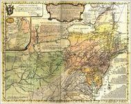
- "A General Map of the Middle British Colonies, in America; Viz Virginia, Mariland, Delaware, Pensilvania, New-Jersey, New-York, Connecticut, and Rhode Island . . . And of Part of New France: Wherein is also shewn the ancient and present Seats of the Indian Nations. By Lewis Evans. 1755."
- Creator:
- Evans, Lewis, 1700?-1756
- Date of Original:
- 1755
- Subject:
- Northeastern States
Early maps
Devices (Heraldry)
Cardinal points
Maps
Cartouches, Ornamental (Decorative arts) - Location:
- Canada, 60.10867, -113.64258
North America, 46.07323, -100.54688 - Medium:
- maps (documents)
- Type:
- Still Image
- Format:
- image/jpeg
- Description:
- A general map of the middle British colonies in America; Virginia, Maryland, Delaware, Pennsylvania, New Jersey, New York, Connecticut, and Rhode Island: of Aquanishuonigy, the country of the confederate Indians; comprehending Aquanishuonigy proper, their place of residence, Ohio and Tiiuxsoxrúntie their deer-hunting countries; Couxsaxráge and Skaniadarade, their beaver-hunting countries; of the Lakes Erie, Ontario and Champlain, and of part of New-France: Wherein is also shown the ancient and present seats of the Indian nations. By Lewis Evans. 1755: Engraved by James Turner in Philadelphia.
- External Identifiers:
- Metadata URL:
- http://digitalarchives.columbusstate.edu/items/show/47
- Language:
- eng
- Extent:
- 50 x 67 cm
- Original Collection:
- J. Kyle Spencer Map Collection (MC 136), Columbus State University Archives, Columbus, Georgia
- Holding Institution:
- Columbus State University. Archives
- Rights:
-
