- Collection:
- J. Kyle Spencer Map Collection
- Title:
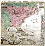
- A Map of the British Empire in America with the French and Spanish Settlements adjacent thereto. Clement Lempriere, designer & craftsman. Published by Henry Popple, 1733.
- Creator:
- Popple, Henry, -1743
- Publisher:
- J. Kyle Spencer Map Collection (MC 136), Columbus State University Archives, Columbus, Georgia
- Date of Original:
- 1733
- Subject:
- Early maps
Devices (Heraldry)
Cardinal points
Maps
North America
Central America
Sailing ships
Atlantic Ocean
Cartouches, Ornamental (Decorative arts) - Location:
- North America, 46.07323, -100.54688
- Medium:
- maps (documents)
- Type:
- Still Image
- Format:
- image/jpeg
- Description:
- This is a reproduction Popple's key map used to index the twenty separate sheets of the bound version of this massive work. He also sold this version as a large roll-up wall map. Popple's father and brother served as secretary to the British Board of Trade and Plantations, and Henry served briefly as its clerk. In that capacity, he saw the need for accurate maps and grasped the commercial possibility of a grandiose series of North American maps. He sold the publication rights before his death in 1743, and his map continued to appear in various forms for years. James Oglethorpe did not return from his first trip to Georgia in times to incorporate his cartographic observations into the first edition, but he did play a role in updating the Georgia portion of later editions.
- External Identifiers:
- Metadata URL:
- http://digitalarchives.columbusstate.edu/items/show/44
- Extent:
- 36.7 x 38 cm
- Holding Institution:
- Columbus State University. Archives
- Rights:
-
