- Collection:
- J. Kyle Spencer Map Collection
- Title:
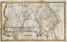
- A map of Georgia, also the Two Floridas from the best Authorities. Doolittle, sculp. Engraved for Morse's Universal Geography. Published by Thomas & Andrews, Boston. [1796].
- Creator:
- Doolittle, Amos, 1754-1832
- Publisher:
- J. Kyle Spencer Map Collection (MC 136), Columbus State University Archives, Columbus, Georgia
- Date of Original:
- 1796
- Subject:
- Georgia
Florida
Early maps
Devices (Heraldry)
Cardinal points
Maps
Cartouches, Ornamental (Decorative arts) - Location:
- United States, Florida, 28.75054, -82.5001
United States, Georgia, 32.75042, -83.50018 - Medium:
- maps (documents)
- Type:
- Still Image
- Format:
- image/png
- Description:
- Amos Doolittle, a New Hampshire cartographer and engraver, produced this map. The level of detail in the Georgia portion of his work is very similar to W. Barker's map in Carey's 1795 atlas. The major distinction is that Doolittle includes West Florida and East Florida as far south at the Matanzas Inlet below St. Augustine.
- External Identifiers:
- Metadata URL:
- http://digitalarchives.columbusstate.edu/items/show/27
- Extent:
- 19 x 31 cm
- Holding Institution:
- Columbus State University. Archives
- Rights:
-
