- Collection:
- J. Kyle Spencer Map Collection
- Title:
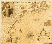
- New England, by Captain John Smith. 1616. From The Generall Historie of Virginia, New-England, and the Summer Isles, 1624.
- Creator:
- Smith, John, 1580-1631
- Publisher:
- J. Kyle Spencer Map Collection (MC 136), Columbus State University Archives, Columbus, Georgia
- Date of Original:
- 1624
- Subject:
- Navigation
Maps
Indians of North America
Devices (Heraldry)
Cardinal points
New England--Description and travel--Early works to 1800
Early maps
Cartouches, Ornamental (Decorative arts) - Location:
- United States, New England, 44.0, -71.0
- Medium:
- maps (documents)
- Type:
- Still Image
- Format:
- image/png
- Description:
- John Smith envisioned creating his own colony to the north of Virginia, a more realistic, better organized settlement with him in charge. In 1614 he explored and surveyed the coast of Maine and Massachusetts Bay and in 1616 published this map, the first to use the name New England. He replaced many of the indigenous names with English ones, but his only surviving place names are Cape Ann, Charles River, and Plymouth. Storms, shipwrecks, pirates, and capture by the French ended his later attempts to settle there, and his map remains as the most positive result of this venture. Thwarted as a colonizer, in part because of his boldness, he settled for writing books about his adventures and the New World.
- External Identifiers:
- Metadata URL:
- http://digitalarchives.columbusstate.edu/items/show/12
- Holding Institution:
- Columbus State University. Archives
- Rights:
-
