- Collection:
- J. Kyle Spencer Map Collection
- Title:
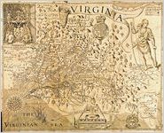
- Virginia. Discovered and described by Captain John Smith, Graven by William Hole.
- Creator:
- Smith, John, 1580-1631
- Publisher:
- J. Kyle Spencer Map Collection (MC 136), Columbus State University Archives, Columbus, Georgia
- Date of Original:
- 1624
- Subject:
- Maps
Indians of North America
Devices (Heraldry)
Cardinal points
Virginia
Early maps
Cartouches, Ornamental (Decorative arts) - Location:
- United States, Virginia, 37.54812, -77.44675
- Medium:
- maps (documents)
- Type:
- Still Image
- Format:
- image/png
- Description:
- Map of Virginia. In 1608, the second year of the colony of Virginia, John Smith led an expedition to reconnoiter the interior and to find food. For several months he explored the Chesapeake Bay and its tributary rivers. His map shows how far he ventured up these rivers. The key reads, "To the crosses hath bin discouerd what beyond is by relation." When Smith returned to Jamestown, he reluctantly became its leader and tried to impose discipline on the colonists for a year. Back in England after 1609, Smith arranged for the publication of his monumental map and book, the source of this map.
- External Identifiers:
- Metadata URL:
- http://digitalarchives.columbusstate.edu/items/show/11
- Extent:
- 32 x 41 cm
- Holding Institution:
- Columbus State University. Archives
- Rights:
-
