- Collection:
- J. Kyle Spencer Map Collection
- Title:
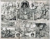
- "Ould Virginia, A description of part of the adventures of Capt. Smith in Virginia." 1624.
- Creator:
- Smith, John, 1580-1631
- Publisher:
- J. Kyle Spencer Map Collection (MC 136), Columbus State University Archives, Columbus, Georgia
- Date of Original:
- 1624
- Subject:
- Maps
Indians of North America
Devices (Heraldry)
Cardinal points
Early maps
Cartouches, Ornamental (Decorative arts) - Location:
- United States, Virginia, 37.54812, -77.44675
- Medium:
- maps (documents)
- Type:
- Still Image
- Format:
- image/png
- Description:
- Map created by Captain John Smith, who displayed in words and pictures his exploits in Virginia. This account of his capture of Indians and their capture of him along with his rescue by Pocahontas made him the first legendary figure in American history. The map in the bottom center panel was published separately in 1624 and then as shown here as a page in Smith's Generall Historie. Cumming and De Vorsey commented on this map by noting how little cartographical impact Smith's work had on later map makers. Burden disagrees and states how useful Smith's work remains for contemporary archaeologists because Smith accurately located 166 Indian villages.
- External Identifiers:
- Metadata URL:
- http://digitalarchives.columbusstate.edu/items/show/10
- Holding Institution:
- Columbus State University. Archives
- Rights:
-
