- Collection:
- Carroll County Photograph Collection
- Title:
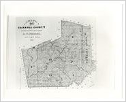
- Map of Carroll County, 1860 / made by authority of the State, B.W. Frobel, Supt. Public Works
- Creator:
- Georgia. Surveyor General Department; Frobel, B. W.
- Date of Original:
- 1860
- Subject:
- Carrollton (Ga.)--Maps
Carroll County (Ga.)--History, Local
Carrollton (Ga.)--History - Location:
- United States, Georgia, Carroll County, Carrollton, 33.58011, -85.07661
- Medium:
- maps (documents)
- Type:
- Still Image
- Format:
- image/jpeg
- Description:
- Black and white photographic reprint of an 1860 map of Carroll County. Map was made by B. W. Frobel, superintendent of public works.
- External Identifiers:
- Metadata URL:
- https://dlg.galileo.usg.edu/id:uwg_carrollphoto_ccp0015
- Digital Object URL:
- https://dlg.galileo.usg.edu/carrollphoto/do:ccp0015
- Language:
- eng
- Original Collection:
- Carroll County photograph collection, LH-0028, Annie Belle Weaver Special Collections, University of West Georgia, Carrollton, Georgia.
- Holding Institution:
- University of West Georgia. Special Collections
- Rights:
-
